Embed Size (px)
Citation preview
This article was downloaded by: [Portland State University]On: 17 October 2014, At: 02:16Publisher: RoutledgeInforma Ltd Registered in England and Wales Registered Number: 1072954 Registered office: Mortimer House,37-41 Mortimer Street, London W1T 3JH, UK
Journal of GeographyPublication details, including instructions for authors and subscription information:http://www.tandfonline.com/loi/rjog20
Google Earth as a (Not Just) Geography Education ToolTodd C. PattersonPublished online: 06 Dec 2007.
To cite this article: Todd C. Patterson (2007) Google Earth as a (Not Just) Geography Education Tool, Journal of Geography,106:4, 145-152, DOI: 10.1080/00221340701678032
To link to this article: http://dx.doi.org/10.1080/00221340701678032
PLEASE SCROLL DOWN FOR ARTICLE
Taylor & Francis makes every effort to ensure the accuracy of all the information (the “Content”) containedin the publications on our platform. However, Taylor & Francis, our agents, and our licensors make norepresentations or warranties whatsoever as to the accuracy, completeness, or suitability for any purpose of theContent. Any opinions and views expressed in this publication are the opinions and views of the authors, andare not the views of or endorsed by Taylor & Francis. The accuracy of the Content should not be relied upon andshould be independently verified with primary sources of information. Taylor and Francis shall not be liable forany losses, actions, claims, proceedings, demands, costs, expenses, damages, and other liabilities whatsoeveror howsoever caused arising directly or indirectly in connection with, in relation to or arising out of the use ofthe Content.
This article may be used for research, teaching, and private study purposes. Any substantial or systematicreproduction, redistribution, reselling, loan, sub-licensing, systematic supply, or distribution in anyform to anyone is expressly forbidden. Terms & Conditions of access and use can be found at http://www.tandfonline.com/page/terms-and-conditions
Google Earth as a (Not Just) Geography Education ToolTodd C. Patterson
ABSTRACTThe implementation of GeographicInformation Science (GIScience)applications and discussion ofGIScience-related themes are usefulfor teaching fundamental geographicand technological concepts. As oneof the newest geographic informationtools available on the World Wide Web,Google Earth has considerable potentialto enhance methods for teachinggeography and helping students developother capabilities. Google Earth’s utilityas a teaching tool in precollegiateenvironments is illustrated throughdevelopment of a South Carolina-based lesson plan focused for seventhgrade students that increases students’geographic awareness while alsobuilding critical thinking, analysis, andinquiry skills in support of variouseducational standards.
Key Words: Google Earth, education,teaching methods standards
Todd C. Patterson is a doctoral candidatein the Department of Geography at theUniversity of South Carolina in Columbia,South Carolina, USA.
INTRODUCTIONThe role of computers in instructional technology has been of interest
particularly since the advent of personal computers. With prices for computingtechnologies continually decreasing, the presence of computers in educationaland home settings has increased dramatically over the last fifteen years.Many schools have advanced beyond the first level of adopting technology(acquisition and implementation of hardware and network wiring), buttechnology-rich curricular activities have yet to be widely introduced (Cateset al. 2003, 155). Implementation of geographic information systems (GIS) inelementary and secondary education has not been very widespread over thesame time period, underscoring a lack of technology-rich curricular activities(Bowman et al. 2005; Baker 2005; Donaldson 2000; Kerski 2000). The advent ofGoogle Earth, however, is a formidable technological tool to help strengthenthese weaknesses in geography curriculum. The purpose of this article is todiscuss the utility of Google Earth as a tool for geography education, witha broad-based South Carolina-oriented lesson plan for seventh graders as anexample.
BACKGROUNDLack of time is a significant barrier to implementing GIS in curricula because
of the need for educators to learn the software and understand the underlyingdata. Educators also need to prepare materials to support lessons, as well asprovide sufficient time for students to learn the software and incorporate thetool in the learning experience (Meyer et al. 1999). Educators’ focus on GIStools has been particularly problematic due to the amount of time required tolearn and apply the tools. The time associated with learning GIS applicationshas been a considerable factor in GIS and related technologies having onlylimited implementation in K–12 classrooms (Bednarz and Bednarz 2004, 24). Forexample, a 2002 Kansas review identified that a high proportion of GIS teacher-training workshops were focused on the development of GIS skills (KanGIS2002); experiences from a comparable Texas institute reiterated that finding(Bowman et al. 2005).
Access to appropriate hardware has traditionally served as a critical barrier toimplementing GIS applications (Meyer et al. 1999). Aside from commitmentof time, Baker (Baker 2005, 44) cited several additional impediments toimplementing GIS in K–12 classroom settings, including: insufficient resources,incompatible computing and network systems, school district demands forsecurity that require leveraging the most current operating system, andseparation of subject disciplines to correspond to a school day’s schedule.
Despite barriers to implementation and utilization, states have beenincreasing pressures to utilize GIS without sufficient support, resources, orlessons. The gulf between demand and ability to implement technologycontinues to widen in the wake of various standards for which educators arebeing held accountable, such as state departments of education and academicdiscipline standards (wherein spatial considerations are becoming increasinglyimportant, including epidemiology and political science) and the recent No ChildLeft Behind initiative (U.S. Department of Education 2002).
Given the advent of computers and the evolution of digital technologies fromvideo games to television, contemporary students have a different manner oflearning and applying tools at their disposal. Growing up in the information age,video and images are a primary means of information gathering for students.Focus on computing equipment has largely evolved to be a primary, daily toolrather than a career path. In order to be productive in the coming years students
Journal of Geography 106: 145–152C©2007 National Council for Geographic Education 145
Dow
nloa
ded
by [
Port
land
Sta
te U
nive
rsity
] at
02:
16 1
7 O
ctob
er 2
014
Todd C. Patterson
need to acquire technologically-based skills early-on andapply them in broad and diverse ways.
Geography, as a unifying discipline, brings muchstrength to educational approaches. GIS, with its emphasison digital information processing and analysis, cancontribute greatly to unify various disciplines that focuson spatial trends and elements. Yet for reasons previouslycited, GIS continues to be underutilized as an instructionaltechnology. Google Earth, albeit having limited spatialanalytical tools in comparison to a true GIS, can beimplemented in classroom settings to help make spatialinformation more relevant to students and teachers at alllevels. Google Earth can also be utilized to enable studentsto meet challenges of various standards-based curriculaby helping them understand information in spatial orgeographic context.
The use of Google Earth not only supports spatialthinking but also helps develop critical analytical skills andprepare students to use more advanced features found ina true GIS. That is true because spatial thinking is “anamalgam of three concepts: concepts of space, tools ofrepresentation, and processes of reasoning” (Committeeon the Support for the Thinking Spatially 2006, xiii).
WHY USE GOOGLE EARTH TO SUPPORT EDUCATIONStudies have demonstrated that the use of online
resources has helped to improve student comprehensionof major concepts and skills while also helping studentsgain confidence in their knowledge of geographic issues(Solem and Gersmehl 2005). Psychological studies havealso demonstrated that the recallability of informationis greater with visual images than text (Wager2005).
Google Earth can help to foster spatial thinking anddevelop critical technology and thinking skills. Lessonplans can be developed to help students consider theconstruct, context, and quality of spatial data. Studentscan also work independently on an interactive basis whilealso collaborating with others with comparable interests.Various Internet-based resources can be incorporatedinto the learning environment to allow students to gaingreater knowledge of areas of particular interest to them.As Leamnson (1999) noted, in many situations learninghappens outside the classroom; by using technologystudents may expand their knowledge and enhance theirthinking and analytical skills and can apply externallearning to situations presented within the classroom.
The use of Google Earth keenly supports the “four E’s”of the learning life cycle model (Cates et al. 2003, 155),allowing students to engage in the lesson, explore the earth,explain what they identify, and evaluate the implicationsof what they are learning. The very nature of GoogleEarth allows students to explore the earth in a dynamicand interactive manner, helping them understand thespatial context of their locale and engage in spatially-oriented learning in an entertaining and meaningfulmanner.
DISADVANTAGES OF USING GOOGLE EARTHAlthough a freeware tool, Google Earth does require
Internet access on a reasonably fast connection. The tool isnot client-side intensive but insufficient bandwidth wouldlimit the utility of Google Earth in the classroom bydisengaging students’ interests if the tool is not responsiveto the user’s requests. Use of the tool has three primarysubstantive requirements comparable to utilizing othertechnologies in the classroom: opportunity (time), motive(desire), and resources (skills and capabilities). The point-and-click interface makes the latter point less intrusive andconsuming than other GIS technologies.
Although Google Earth and its related sites have abreadth of data available, the student would need tounderstand how to create his or her own account to searchfor data not included in the Google Earth interface andthen how to open the dataset once a desirable dataset isidentified. In some cases the true accuracy and authenticityof data may not be readily available, which could pose risksto the educational value of the lesson.
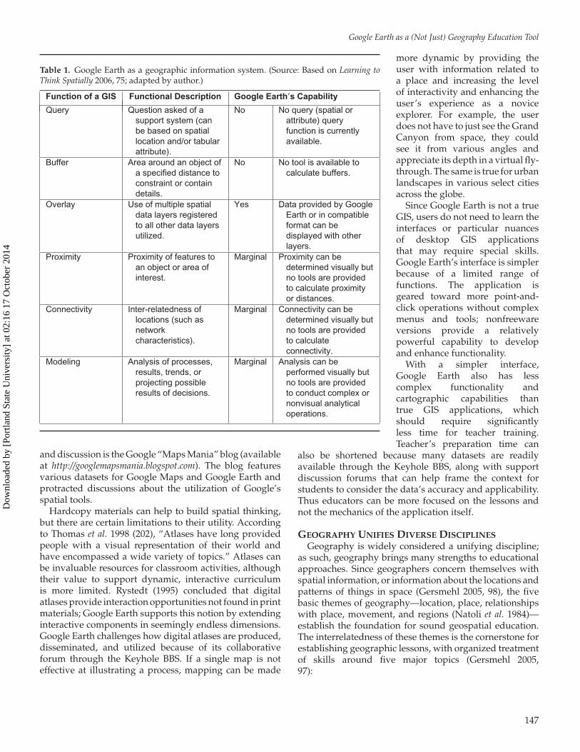
Google Earth is also not a true GIS (Table 1). Theintroductory concepts can open the door to expanded usein more sophisticated tools, but Google Earth has limitedcapabilities and tools to support true spatial analyticaloperations. The tool does not have a query capability or thefunctionality to perform complex spatial operations—evenin the nonfreeware versions.
ADVANTAGES TO USING GOOGLE EARTHDespite some disadvantages, Google Earth has a
number of advantages to support its utilization inprecollegiate educational environments. Technology byitself is worthless, but as a tool technology offersenormous potential to extend our capabilities. GoogleEarth supports a student’s learning because it also canserve as an entertainment venue. The incorporation ofaffective components, or visual and emotional images tocommunicate and motivate, help make Google Earth apowerful classroom tool.
Unlike many client-side applications, students are notrequired to be at school in order to use the application.The free version of Google Earth can be installed by anyuser, thus allowing students to utilize the applicationoutside the educational atmosphere and not be subject tolicensing requirements many commercial off-the-shelf GISapplications impose.
The Google Earth Community and Google’s Keyholemapping service, Bulletin Board Service (BBS; available athttp://bbs.keyhole.com), feature a variety of data layersthat include supplementary readings and supportingphotos and videos. There are also increasingly moreservices available to Google Earth with streaming media(for near-real-time information, such as satellite locationsand weather updates). Keyhole BBS not only provides databut it also serves as a collaborative discussion forum forusers to discuss data implications and evolution, as wellas peripheral ideas. Another supplemental source of data
146
Dow
nloa
ded
by [
Port
land
Sta
te U
nive
rsity
] at
02:
16 1
7 O
ctob
er 2
014
Google Earth as a (Not Just) Geography Education Tool
Table 1. Google Earth as a geographic information system. (Source: Based on Learning toThink Spatially 2006, 75; adapted by author.)
Function of a GIS Functional Description Google Earth’s Capability
Query Question asked of asupport system (canbe based on spatiallocation and/or tabularattribute).
No No query (spatial orattribute) queryfunction is currentlyavailable.
Buffer Area around an object ofa specified distance toconstraint or containdetails.
No No tool is available tocalculate buffers.
Overlay Use of multiple spatialdata layers registeredto all other data layersutilized.
Yes Data provided by GoogleEarth or in compatibleformat can bedisplayed with otherlayers.
Proximity Proximity of features toan object or area ofinterest.
Marginal Proximity can bedetermined visually butno tools are providedto calculate proximityor distances.
Connectivity Inter-relatedness oflocations (such asnetworkcharacteristics).
Marginal Connectivity can bedetermined visually butno tools are providedto calculateconnectivity.
Modeling Analysis of processes,results, trends, orprojecting possibleresults of decisions.
Marginal Analysis can beperformed visually butno tools are providedto conduct complex ornonvisual analyticaloperations.
and discussion is the Google “Maps Mania” blog (availableat http://googlemapsmania.blogspot.com). The blog featuresvarious datasets for Google Maps and Google Earth andprotracted discussions about the utilization of Google’sspatial tools.
Hardcopy materials can help to build spatial thinking,but there are certain limitations to their utility. Accordingto Thomas et al. 1998 (202), “Atlases have long providedpeople with a visual representation of their world andhave encompassed a wide variety of topics.” Atlases canbe invaluable resources for classroom activities, althoughtheir value to support dynamic, interactive curriculumis more limited. Rystedt (1995) concluded that digitalatlases provide interaction opportunities not found in printmaterials; Google Earth supports this notion by extendinginteractive components in seemingly endless dimensions.Google Earth challenges how digital atlases are produced,disseminated, and utilized because of its collaborativeforum through the Keyhole BBS. If a single map is noteffective at illustrating a process, mapping can be made
more dynamic by providing theuser with information related toa place and increasing the levelof interactivity and enhancing theuser’s experience as a noviceexplorer. For example, the userdoes not have to just see the GrandCanyon from space, they couldsee it from various angles andappreciate its depth in a virtual fly-through. The same is true for urbanlandscapes in various select citiesacross the globe.
Since Google Earth is not a trueGIS, users do not need to learn theinterfaces or particular nuancesof desktop GIS applicationsthat may require special skills.Google Earth’s interface is simplerbecause of a limited range offunctions. The application isgeared toward more point-and-click operations without complexmenus and tools; nonfreewareversions provide a relativelypowerful capability to developand enhance functionality.
With a simpler interface,Google Earth also has lesscomplex functionality andcartographic capabilities thantrue GIS applications, whichshould require significantlyless time for teacher training.Teacher’s preparation time can
also be shortened because many datasets are readilyavailable through the Keyhole BBS, along with supportdiscussion forums that can help frame the context forstudents to consider the data’s accuracy and applicability.Thus educators can be more focused on the lessons andnot the mechanics of the application itself.
GEOGRAPHY UNIFIES DIVERSE DISCIPLINESGeography is widely considered a unifying discipline;
as such, geography brings many strengths to educationalapproaches. Since geographers concern themselves withspatial information, or information about the locations andpatterns of things in space (Gersmehl 2005, 98), the fivebasic themes of geography—location, place, relationshipswith place, movement, and regions (Natoli et al. 1984)—establish the foundation for sound geospatial education.The interrelatedness of these themes is the cornerstone forestablishing geographic lessons, with organized treatmentof skills around five major topics (Gersmehl 2005,97):
147
Dow
nloa
ded
by [
Port
land
Sta
te U
nive
rsity
] at
02:
16 1
7 O
ctob
er 2
014
Todd C. Patterson
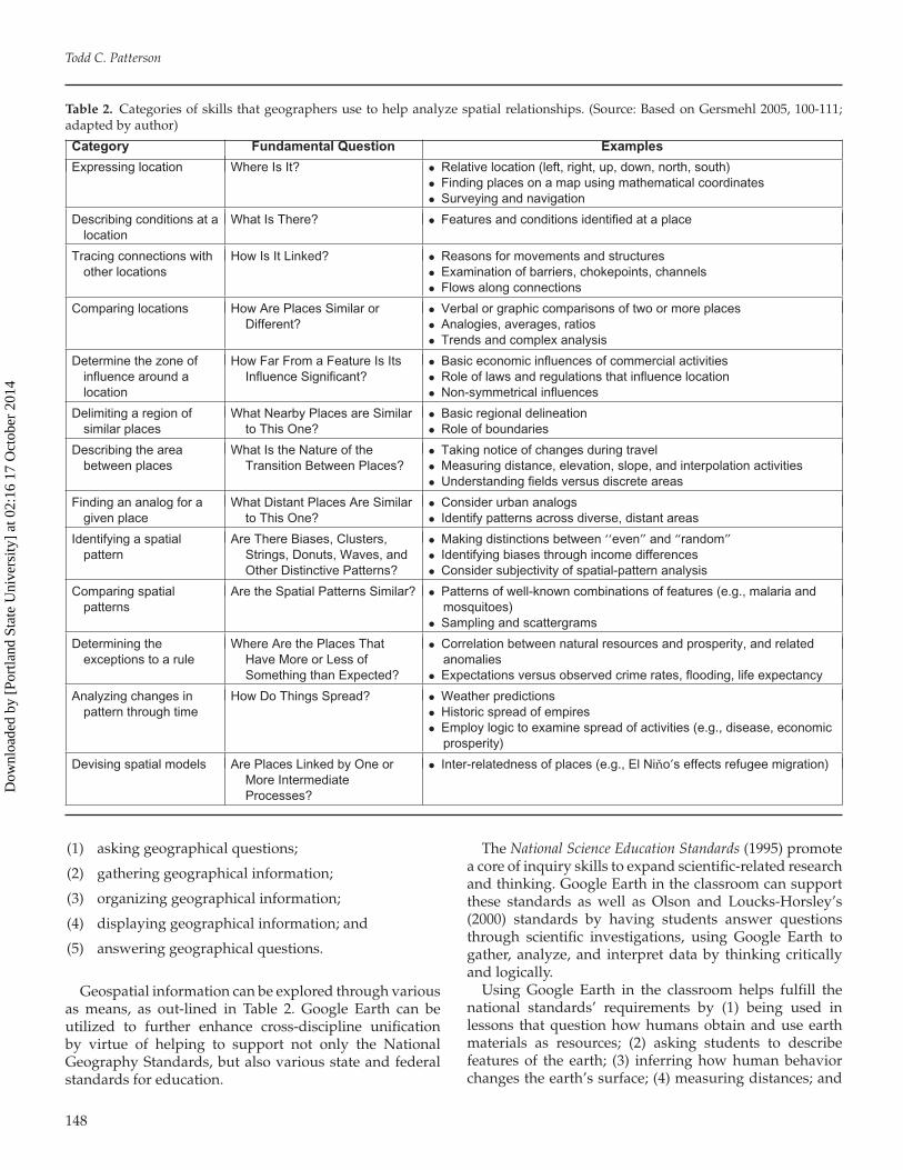
Table 2. Categories of skills that geographers use to help analyze spatial relationships. (Source: Based on Gersmehl 2005, 100-111;adapted by author)
Category Fundamental Question Examples
Expressing location Where Is It? • Relative location (left, right, up, down, north, south)• Finding places on a map using mathematical coordinates• Surveying and navigation
Describing conditions at alocation
What Is There? • Features and conditions identified at a place
Tracing connections withother locations
How Is It Linked? • Reasons for movements and structures• Examination of barriers, chokepoints, channels• Flows along connections
Comparing locations How Are Places Similar orDifferent?
• Verbal or graphic comparisons of two or more places• Analogies, averages, ratios• Trends and complex analysis
Determine the zone ofinfluence around alocation
How Far From a Feature Is ItsInfluence Significant?
• Basic economic influences of commercial activities• Role of laws and regulations that influence location• Non-symmetrical influences
Delimiting a region ofsimilar places
What Nearby Places are Similarto This One?
• Basic regional delineation• Role of boundaries
Describing the areabetween places
What Is the Nature of theTransition Between Places?
• Taking notice of changes during travel• Measuring distance, elevation, slope, and interpolation activities• Understanding fields versus discrete areas
Finding an analog for agiven place
What Distant Places Are Similarto This One?
• Consider urban analogs• Identify patterns across diverse, distant areas
Identifying a spatialpattern
Are There Biases, Clusters,Strings, Donuts, Waves, andOther Distinctive Patterns?
• Making distinctions between ‘‘even” and “random”• Identifying biases through income differences• Consider subjectivity of spatial-pattern analysis
Comparing spatialpatterns
Are the Spatial Patterns Similar? • Patterns of well-known combinations of features (e.g., malaria andmosquitoes)
• Sampling and scattergrams
Determining theexceptions to a rule
Where Are the Places ThatHave More or Less ofSomething than Expected?
• Correlation between natural resources and prosperity, and relatedanomalies
• Expectations versus observed crime rates, flooding, life expectancy
Analyzing changes inpattern through time
How Do Things Spread? • Weather predictions• Historic spread of empires• Employ logic to examine spread of activities (e.g., disease, economic
prosperity)
Devising spatial models Are Places Linked by One orMore IntermediateProcesses?
• Inter-relatedness of places (e.g., El Nino’s effects refugee migration)
(1) asking geographical questions;
(2) gathering geographical information;
(3) organizing geographical information;
(4) displaying geographical information; and
(5) answering geographical questions.
Geospatial information can be explored through variousas means, as out-lined in Table 2. Google Earth can beutilized to further enhance cross-discipline unificationby virtue of helping to support not only the NationalGeography Standards, but also various state and federalstandards for education.
The National Science Education Standards (1995) promotea core of inquiry skills to expand scientific-related researchand thinking. Google Earth in the classroom can supportthese standards as well as Olson and Loucks-Horsley’s(2000) standards by having students answer questionsthrough scientific investigations, using Google Earth togather, analyze, and interpret data by thinking criticallyand logically.
Using Google Earth in the classroom helps fulfill thenational standards’ requirements by (1) being used inlessons that question how humans obtain and use earthmaterials as resources; (2) asking students to describefeatures of the earth; (3) inferring how human behaviorchanges the earth’s surface; (4) measuring distances; and
148
Dow
nloa
ded
by [
Port
land
Sta
te U
nive
rsity
] at
02:
16 1
7 O
ctob
er 2
014
Google Earth as a (Not Just) Geography Education Tool
(5) using other thinking and analytical capacities. GoogleEarth frequently posts data of recent significance onits main Web page, http://earth.google.com/, such asupdated imagery during hurricanes Katrina and Rita inlate 2005. Students can read about the current event, viewphotos and video in the context of the event, and writeanalyses of its implications, which provide students withan implicit understanding of spatial information whileexplicitly building skills in critical thinking, analysis, andwriting.
The Principles and Standards for School Mathematics(National Council of Teachers of Mathematics 2000)includes requirements for measurement, data analysis,and probability, reasoning and proof, communication,connections, and representation skills among students.Although the true mathematical functions in GoogleEarth are not comparable to those present in a trueGIS, lessons can be developed to introduce studentsto each of the concepts, again helping to build spatialskills while explicitly developing other capabilities. Suchlesson incorporation is consistent with the InternationalSociety for Technology in Education’s (2000) EducationalTechnology Standards and Performance Indicators for AllTeachers that supports the planning and design of learningenvironments and experiences in the context of a broadcurriculum, technology operations, and related concepts.
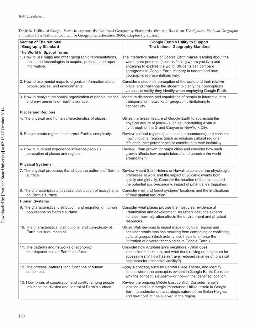
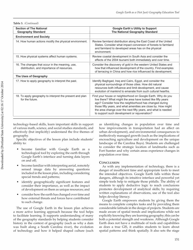
The ability to support thinking in spatial terms and helpstudents to understand natural and cultural phenomenais certainly a strength of Google Earth. Lessons canbe devised to help educators teach about place whileproviding students an interactive tool. Students can alsolearn some attributes associated with place, includingbasic relationships among features. Each of the eighteenNational Geography Standards is supported (Table 3),and Google Earth and its associated resources providethe potential to incorporate multiple standards across thesix sections. Table 3 provides general applications forutilizing Google Earth. Specific use of Google Earth foreach of the geography standards could be consideredin significantly more depth and as separate papers. Theimplications of Google Earth to support the NationalGeography Standards are considered in some depth in thelesson plan section of Table 3.
Google Earth is a particularly useful tool to helpintroduce students to the five themes of geography—location, place, relationships with place, movement, andregions (Natoli et al. 1984). Students can begin tounderstand the notion of scale by starting with a globalperspective (which enforces the spherical nature of Earth)and zooming to different areas.
As a digitally-based resource, Google Earth alsosupports the technology standards (National EducationalTechnology 1998) because it provides productivity toolsto collaborate and communicate, and locate, evaluate,and collect information from a variety of sources. GoogleEarth provides technology resources for solving problemsand making informed decisions—important capabilities
students need to be productive members of society.(Illustrations of these resources and applications aresuggested in Tables 1, 2, and 3, and outlined in the includedlesson plan.)
Advanced versions of Google Earth, while not free,also provide the ability to create spatial data and uploadto the forums discussed above. While the professionalversion could be cost-prohibitive for many schools, theimplications of developing local data sets to enhancelearning by understanding a student’s own environmentare tremendous. It should also be noted that the GoogleEarth data format is a customized eXtensible MarkupLanguage (XML) text-based format that individuals couldcreate and edit with a simple text editor, such as theWindows Notepad. The XML-based Keyhole MarkupLanguage (KML) specifications are publicly availableshould students wish to develop their own datasets andlearn the particular technology.
TOWARDS IMPLEMENTATION: A SEVENTH-GRADELESSON PLAN
A South Carolina-oriented lesson plan targeted for theseventh grade was developed to help illustrate the utilityof Google Earth as an educational tool. This involvedincorporating several types of data into a single KMLfile. The seventh grade was chosen to apply Bloom’staxonomy of cognition to support the creation of learningobjectives at an appropriate age level (Lever-Duffy et al.2005, 44–45) in order to demonstrate the applicability ofthe various standards and the utility of Google Earth. Datain the KML file are meant to illustrate both the breadthand depth of Google Earth as a potential educationaltool.
The lesson plan involved using data in the KML andbase imagery data available directly through Google Earth.The lesson plan is designed to help students along severaleducational fronts, specifically:
� knowledge (memorizing, recognizing, recalling);� comprehension (organizing, describing, interpre-
ting);� application (applying information, solving
problems, finding new ways to use information);� analysis (finding underlying structures, separate
whole into components, identify motives andhidden meanings);
� synthesis (compiling, combining); and� evaluation (making value decisions and judg-
ments).The South Carolina standards at the seventh grade level
incorporate these areas broadly in the context of worldhistory. The challenge for students in the lesson planis to have them think contextually, relating geographicspace and landscapes with historical processes. Thequestions to be answered in the lesson plan help studentsidentify patterns, consider complex relationships, develop
149
Dow
nloa
ded
by [
Port
land
Sta
te U
nive
rsity
] at
02:
16 1
7 O
ctob
er 2
014
Todd C. Patterson
Table 3. Utility of Google Earth to support the National Geography Standards. (Source: Based on The Eighteen National GeographyStandards (The National Council for Geographic Education 2006); adapted by author.)
Section of The NationalGeography Standard
Google Earth’s Utility to SupportThe National Geography Standard
The World In Spatial Terms1. How to use maps and other geographic representations,
tools, and technologies to acquire, process, and reportinformation.
The interactive nature of Google Earth makes learning about theworld more personal (such as finding where you live) andengaging to explore the world. Students can comparecartograms to Google Earth imagery to understand howgeographic representations vary.
2. How to use mental maps to organize information aboutpeople, places, and environments.
Consider a student’s perception of the world and their relativeplace, and challenge the student to clarify their perceptionsversus the reality they identify when employing Google Earth.
3. How to analyze the spatial organization of people, places,and environments on Earth’s surface.
Measure distances and capabilities of people to interact due totransportation networks or geographic limitations toconnectivity.
Places and Regions
4. The physical and human characteristics of places. Utilize the terrain feature of Google Earth to appreciate thephysical nature of place—such as undertaking a virtualfly-through of the Grand Canyon or NewYork City.
5. People create regions to interpret Earth’s complexity. Review political regions (such as state boundaries) and considerhow functional regions (such as religious cultural regions)influence their permanence or contribute to their instability.
6. How culture and experience influence people’sperception of places and regions.
Review urban growth for major cities and consider how suchgrowth affects how people interact and perceive the worldaround them.
Physical Systems
7. The physical processes that shape the patterns of Earth’ssurface.
Review Mount Saint Helens or Hawaii to consider the physiologicprocesses at work and the impact of volcanic events bothlocally and globally. Consider the location of fault zones andthe potential socio-economic impact of potential earthquakes.
8. The characteristics and spatial distribution of ecosystemson Earth’s surface.
Consider river and forest systems’ locations and the implicationsof their spatial reduction.
Human Systems
9. The characteristics, distribution, and migration of humanpopulations on Earth’s surface.
Consider what places provide the most clear evidence ofurbanization and development. As urban locations expandconsider how migration affects the environment and physicalresources.
10. The characteristics, distributions, and com-plexity ofEarth’s cultural mosaics.
Utilize Web services to ingest maps of cultural regions andconsider ethnic tensions resulting from competing or conflictingcultural groups. (Such activity also helps to enforce theutilization of diverse technologies in Google Earth.)
11. The patterns and networks of economicinterdependence on Earth’s surface.
Consider how Afghanistan’s neighbors. (What doeslandlockedness mean, and what does relying on neighbors foraccess mean? How has air travel reduced reliance on physicalneighbors for economic viability?)
12. The process, patterns, and functions of humansettlement.
Apply a concept, such as Central Place Theory, and identifyplaces where the concept is evident in Google Earth. Considerwhy the concept is evident—or not—in the identified location.
13. How forces of cooperation and conflict among peopleinfluence the division and control of Earth’s surface.
Review the ongoing Middle East conflict. Consider Israel’slocation and its strategic importance. Utilize terrain in GoogleEarth to understand the strategic nature of the Golan Heights,and how conflict has evolved in the region.
150
Dow
nloa
ded
by [
Port
land
Sta
te U
nive
rsity
] at
02:
16 1
7 O
ctob
er 2
014
Google Earth as a (Not Just) Geography Education Tool
Table 3. (Continued)
Section of The NationalGeography Standard
Google Earth’s Utility to SupportThe National Geography Standard
Environment and Society
14. How human actions modify the physical environment. Review farmland distribution along the East Coast of the UnitedStates. Consider what impact conversion of forests to farmlandand farmland to developed areas has on the physicalenvironment.
15. How physical systems affect human systems. Review coastal development in South Asia and consider theeffects of the 2004 tsunami both immediately and over time.
16. The changes that occur in the meaning, use,distribution, and importance of resources.
Consider the discovery of gold in the western United States andhow that influenced development of the country. Find examplesof terracing in China and how rice influenced its development.
The Uses of Geography
17. How to apply geography to interpret the past. Identify Baghgad, Iraq and Cairo, Egypt, and consider thephysical surroundings of those cities. How did naturalresources both influence and limit development, and causeevolution of mankind to emanate from such cultural hearths.
18. To apply geography to interpret the present and planfor the future.
Find your house or neighborhood on Google Earth. Why do youlive there? What might the area have looked like fifty yearsago? Consider how the neighborhood has changed duringthose fifty years, and what amenities are close by. How mightthe area change over the next fifty years, and what is neededto support such development or rejuvenation?
technology-based skills, learn important skills in supportof various math, science, and social studies standards, andeffectively (but implicitly) understand the five themes ofgeography.
Specific objectives of the lesson plan include students’ability to:
� become familiar with Google Earth as atechnological tool by exploring the earth throughGoogle Earth’s interface and turning data layerson and off;
� become familiar with interpreting aerial, remotelysensed image data by answering questionsincluded in the lesson plan, including consideringspecial trends and patterns;
� identify geographically significant features andconsider their importance, as well as the impactof development on them as unique resources; and
� consider how the earth has changed over time andhow external threats and forces have contributedto such change.
The use of Google Earth in the lesson plan achievesa more active learning approach because the tool helpsto facilitate learning. It supports understanding of manyof the geography standards by helping students considerhistory in the context of geography (such as why a damwas built along a South Carolina river), the evolutionof technology and how it helped shaped culture (such
as identifying changes in population over time andhow improvements in transportation had an affect onurban development), and environmental consequences toineffectively managed growth (such as the implications ofencroaching agriculture and development on the uniquelandscape of the Carolina Bays). Students are challengedto consider the strategic location of landmarks such asFort Sumter and why certain areas experience changes inpopulation over time.
CONCLUSIONAs with any implementation of technology, there is a
danger of insufficient time and appropriate tools to meetthe intended objectives. Google Earth falls within thosedangers, although its intuitive interface and powerful yetsimple tools help to mitigate those pitfalls. The ability ofstudents to apply deductive logic to reach conclusionspromotes development of analytical skills; by requiringwritten explanations of observations, use of the tool alsohelps develop literacy.
Google Earth empowers students by giving them themeans to complete complex tasks and by providing themconsiderable latitude in the design of projects. Students aremade aware of spatial trends and implications while notexplicitly knowing they are learning geography; this can beboth a potential strength and weakness. Although GoogleEarth does not have a multitude of tools and capabilitiesas does a true GIS, it enables students to learn aboutspatial patterns and think spatially. It also sets the stage
151
Dow
nloa
ded
by [
Port
land
Sta
te U
nive
rsity
] at
02:
16 1
7 O
ctob
er 2
014
Todd C. Patterson
for students to engage in GIS as they begin to ask morecomplex and detailed questions after they reach the limitof Google Earth’s utility.
This discussion is intended to scratch the surface ofthe utility of Google Earth as an educational tool. Therecontinues to be a need for researchers and educatorsto engage in meaningful dialogue regarding the prosand cons of the technology. A further implication forfuture research includes developing scientifically-derivedmeasurement criteria to critically evaluate the effectivenessof students’ learning using Google Earth.
REFERENCESBaker, T. R. 2005. Internet-based GIS mapping in support
of K–12 education. The Professional Geographer 57(1):44–50.
Bednarz, R. S., and S. W. Bednarz. 2004. Geographyeducation: The glass is half full and it’s getting fuller.The Professional Geographer 56(1):22–27.
Bowman, E., R. Kilian-Smith, and S. Brown. 2005.Developing teacher capacity to implement GIS in thegeography curriculum. Proceedings of the 2005 ESRIEducation User Conference, San Diego, California,USA.
Cates, W. M., B. Price, and A. M. Bodzin. 2003.Implementing technology-rich curricular materials:Findings from the exploring life project. In Technologyin Education: A Twenty-Year Retrospective, eds. D.Lamont Johnson, and Cleborne D. Maddux. New York:Haworth Press.
Committee on the Support for Thinking Spatially. 2006.Learning To Think Spatially: GIS as a Support System inthe K–12 Curriculum. Washington, D.C.: The NationalAcademies Press.
Donaldson, D. 2000. Public high schools’ ability to supportGIS: An Ohio case study. Geographical Bulletin 41(2):91–102.
Gersmehl, P. 2005. Teaching Geography. New York: TheGuilford Press.
International Society for Technology in Education. 2000.Educational Technology Standards and PerformanceIndicators for All Teachers. Eugene, Oregon:International Society for Technology in Education.
International Society for Technology in Education. 1998.National Educational Technology Standards for Students—Connective Curriculum and Technology. Eugene, Oregon:International Society for Technology in Education.
KanGIS. 2002. GIS for teachers: Training and educationprograms. http://kangis.org/learn (accessed April 18,2006).
Kerski, J. J. 2000. The implementation and effectivenessof geographic information systems technology andmethods in secondary education. Ph.D. diss.,University of Colorado at Boulder.
Leamnson, R. 1999. Thinking About Teaching and Learning:Developing Habits of Learning with First Year College andUniversity Students. Sterling, Virginia: Stylus.
Lever-Duffy, J., J. B. McDonald, and A. P. Mizell. 2005.Teaching and Learning with Technology. 2nd ed. Boston:Pearson.
Meyer, J. W., J. Butterick, M. Olkin, and G. Zack. 1999. GISin the K–12 curriculum: A cautionary note. ProfessionalGeographer 51(4):571–578.
The National Council for Geographic Education.The Eighteen National Geography Standards. 2006.Washington, D.C.: The National Council forGeographic Education. http://www.ncge.org/publications/tutorial/standards/(accessed April 18,2006).
National Council of Teachers of Mathematics. 2000.Principles and Standards for School Mathematics.Reston, Virginia: National Council of Teachers ofMathematics.
National Research Council. 1995. National Science EducationStandards. Washington, D.C.: National Academy Press.
Natoli, S. J., R. Boehm, J. B. Kracht, D. A. Lanegran,J. J. Monk, and R. W. Morrill. 1984. Guidelinesfor Geographic Education: Elementary and SecondarySchools. Washington, D.C.: Association of AmericanGeographers and National Council for GeographicEducation.
Olson, S., and S. Loucks-Horsley, eds. 2000. Inquiry and theNational Science Education Standards. Washington, D.C.:National Academy Press.
Rystedt, B. 1995. Current trends in electronic atlasproduction. Cartographic Perspectives 20:5–11.
Solem, M., and P. Gersmehl. 2005. Online GlobalGeography Modules Enhance UndergraduateLearning. AAG Newsletter 40(8):11.
Thomas, D. S. K., J. T. Mitchell, M. S. Scott, and S. L. Cutter.1998. Developing a digital atlas of environmental risksand hazards. Journal of Geography 98(5):201–207.
U.S. Department of Education. 2002. The No ChildLeft Behind Act of 2001. Washington, D.C.: U.S.Department of Education. http://www.ed.gov/nclb/overview/intro/execsumm.doc. (accessed April 18,2006).
Wager, W. 2005. Integrating Technology into Instruction.University of South Carolina Workshop.
152
Dow
nloa
ded
by [
Port
land
Sta
te U
nive
rsity
] at
02:
16 1
7 O
ctob
er 2
014