Embed Size (px)
Citation preview

Site Summary Report GOLDSTON DUMP
ID NUMBER: NONCD0000227 Chatham County, North Carolina
Senate Bill 1492
State of North Carolina State Contract N06010S
MM&A Project Number NCUL145
Prepared For:
North Carolina Department of Environment and Natural Resources Division of Waste Management - Superfund Section
Inactive Hazardous Sites Branch 401 Oberlin Road, Suite 150
Raleigh, NC 27605
Prepared By:
MARSHALL MILLER & ASSOCIATES, INC. 5900 Triangle Drive Raleigh, NC 27617
(Ph.) 919-786-1414 (Fax) 919-786-1418
May 7, 2010
Prepared By: Reviewed By:
Jacob A. Hodges Project Manager
Christopher Rook Project Scientist

Goldston Dump Chatham County, North Carolina
NONCD0000227 May 7, 2010
NCUL145/Goldston Dump
TABLE OF CONTENTS PAGE
1.0 SITE INFORMATION ...................................................................................... 1
2.0 AREAS OF NOTE .............................................................................................. 1
3.0 SITE LOCATION RESEARCH SUMMARY ................................................. 2
3.1 SITE SUMMARY ................................................................................... 2
3.1.1 Site Ownership and Dates of Operation ................................... 2
3.1.2 Site Location ................................................................................ 3
3.1.3 General Site Description ............................................................ 3
3.2 SITE CONDITIONS .............................................................................. 4
3.2.1 On-Site Structures ...................................................................... 4
3.2.2 Current Site Usage ...................................................................... 4
3.2.3 On-Site Water Supply Wells and Intakes ................................. 4
3.2.4 Surface Water Features ............................................................. 4
3.2.5 Disposal Area .............................................................................. 4
3.2.6 Disposal Area Conditions ........................................................... 4
3.2.7 Evidence of Human Activity ...................................................... 5
3.2.8 Potential Landfill Gas Migration Pathways ............................. 5
3.2.9 Physical Barriers ......................................................................... 5
3.2.10 Other Pertinent Information ..................................................... 5
3.3 VICINITY CONDITIONS ..................................................................... 6
3.3.1 Structures Located within 50 Feet of the Disposal Area ......... 6
3.3.2 Water Supply Wells and Intakes ............................................... 6
3.3.3 Current Land Usage ................................................................... 6
3.3.4 Surface Water Features ............................................................. 7
4.0 AERIAL PHOTOGRAPHY REVIEW ............................................................ 7

Goldston Dump Chatham County, North Carolina
NONCD0000227 May 7, 2010
NCUL145/Goldston Dump
TABLE OF CONTENTS (Continued)
FIGURES Figure 1 - Topographic Map Figure 2 - Property/Water Well Location Map Figure 3 - Vicinity Map Figure 4 - Site Location Map
TABLE Table 1 - Tabulated GPS Coordinates
APPENDICES
APPENDIX A Chatham County Register of Deeds - Deeds Chatham County Tax Administration Record Search - 2009 Property Report Card
APPENDIX B Land Disposal Site Modification Report
APPENDIX C Records of Communication
APPENDIX D Site Inspection Photodocumentation
APPENDIX E Field Reconnaissance Sheet
APPENDIX F Aerial Photographs
Chatham County Soil and Water Conservation District, 1955 Chatham County Soil and Water Conservation District, 1966 Chatham County Soil and Water Conservation District, 1979 Chatham County Soil and Water Conservation District, 1983 United States Geological Survey, 1998 United States Department of Agriculture, Aerial Photography Field Office 2009

Goldston Dump Chatham County, North Carolina
NONCD0000227 May 7, 2010
NCUL145/Goldston Dump 1
1.0 SITE INFORMATION
ID NUMBER: NONCD0000227 SITE NAME: Goldston Dump LOCATION: Terminus of an unmaintained dirt road which intersects St. Luke Church
Road (SR-2135) behind the McLaughlin Community Center, approximately 0.77 miles north of the intersection of St. Luke Church Road and Henry Oldham Road (SR-2412).
COUNTY: Chatham
LANDFILL SIZE: 2.37 acres
PROPERTY (SITE) SIZE: 10.5 acres DATE OPENED: Circa 1966 DATE CLOSED: 1973
SITE OWNERS: Mr. Joseph Lee Utley OWNER CONTACT: Joseph Lee Utley OWNER ADDRESS: 1907 Pendleton Street, Savannah, Georgia 34105 OWNER TELEPHONE NUMBER: (912) 346-0635
PARCEL ID NO.: 0009716 DEED REFERENCE: Deed Book 426, Page Number 142
COORDINATES (AT POINT OF ENTRANCE TO SITE): STATE PLANE COORDINATES (SPC); NAD83, METERS
X: 583794.78; Y: 203051.87 DEGREES, MINUTES, SECONDS (DMS); WGS 84
Lat.: N 35° 34’ 48.373”; Long.: W 79° 17’ 05.093”
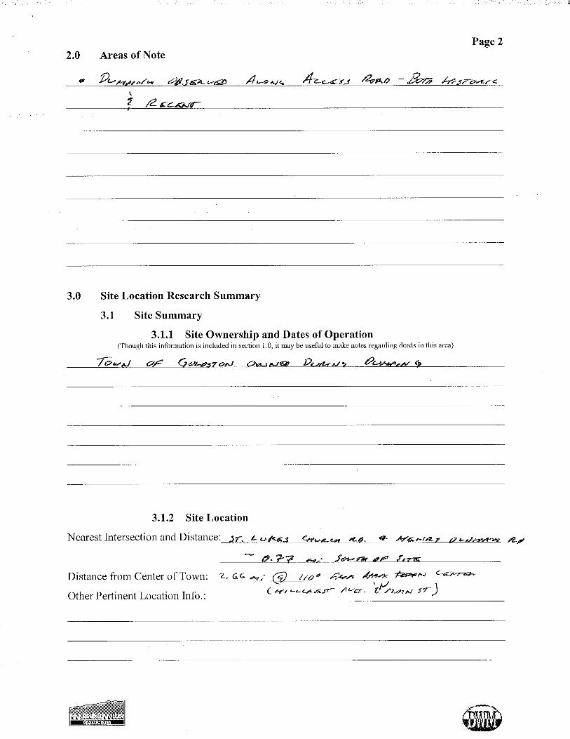
2.0 AREAS OF NOTE
The following areas of note were observed during the site inspection: • Several mounds, consisting of both recent and historic debris, were observed along the
Site access road.
• Exposed debris at the Site included metal and glass debris and a large number of discarded tires.

Goldston Dump Chatham County, North Carolina
NONCD0000227 May 7, 2010
NCUL145/Goldston Dump 2
3.0 SITE LOCATION RESEARCH SUMMARY
Marshall Miller & Associates, Inc. (MM&A) has completed an assessment of the old landfill
site listed as the Goldston Dump located east of the Town of Goldston in Chatham County,
North Carolina. The assessment included historical research and a site inspection to confirm
the Site location, to develop an understanding of the operational and development history,
and to evaluate the current Site and vicinity conditions.
For the purpose of this report, the term “Site” refers to the property on which the disposal
area is located. The term “disposal area” is specific to the actual location where refuse was
buried or disposed.
3.1 SITE SUMMARY
3.1.1 Site Ownership and Dates of Operation
According to records available from the Chatham County Register of Deeds, the Town of
Goldston purchased the Site from Roland Jones and wife, Inez Jones, on June 29, 1966
(Deed book 316, Page Number 543). The Town of Goldston owned the Site through the
time during which dumping operations were active and subsequently sold the Site to
William Harold Murchison and wife, Lydia S. Murchison, on October 1, 1975 (Deed Book
391, Page Number 688). Joseph Lee Utley purchased the Site from Mr. and Mrs. Murchison
on June 28, 1979 (Deed Book 426, Page Number 142), and has owned the Site since that
time. Copies of these deeds and the 2009 Property Report Card are provided in Appendix
A.
Although no records could be located to confirm an opening date for the Site, nor could any
residents recall when the Site began accepting waste, based upon review of aerial
photography and the ownership history of the Site, it is likely that dumping may have begun
as early as 1966, when the Town of Goldston purchased the Site. The Land Disposal Site
Modification Report dated October 19, 1973, and filed at the North Carolina Department of
Environment and Natural Resources (NCDENR), Division of Solid Waste office in Raleigh,
North Carolina, notes that modifications at the Site were completed on that same date and

Goldston Dump Chatham County, North Carolina
NONCD0000227 May 7, 2010
NCUL145/Goldston Dump 3
that waste was routed to the Chatham Co. Landfill in Pittsboro, NC. A copy of the Land
Disposal Site Modification Report is included as Appendix B.
MM&A obtained permission to access the Site from Mr. Joseph Lee Utley, current Site
owner, prior to performing an on-site inspection. A copy of the Request for Site Access
Letter and follow-up communication logs are included as Appendix B.
3.1.2 Site Location
The Site is located approximately 2.66 miles southeast of the intersection of Hillcrest
Avenue and North Main Street in the Town of Goldston with a bearing of 110 degrees from
true north. The Site location and the surrounding area are depicted in the various maps
included with this report (Figures 1 through 4).
3.1.3 General Site Description
The Site is located in a rural area of southern Chatham County historically occupied by
farmland. The Site is bordered to the north and south by a combination of cleared fields and
undeveloped woodland and to the east and west by generally undeveloped woodland.
The Site occupies an area of approximately 10.5 acres, according to the 2009 Property
Report Card, and is generally rectangular. The disposal area occupies the western-most
2.37 acres of the Site, in an area of undeveloped woodland adjacent to deforested fields in
the surrounding properties.
The terrain within the Site slopes toward Cedar Branch, which flows to the south through
the central portion of the Site, with a total relief of 55 feet from the west and 15 feet from
the east. According to the United States Department of Agriculture, Natural Resources
Conservation Service’s Web Soil Survey, the soil within the majority of the Site is classified
as Carbonton-Brickhaven complex, with Riverview silt loam in the vicinity of Cedar
Branch, and Peawick fine sandy loam to the east.

Goldston Dump Chatham County, North Carolina
NONCD0000227 May 7, 2010
NCUL145/Goldston Dump 4
3.2 SITE CONDITIONS
The following sections discuss the conditions of the Site based on historical research and the
site inspection. Captioned photographs are included in Appendix D to illustrate the
condition of the Site as observed during the site visit that was performed on April 28, 2010.
A copy of the Field Reconnaissance Sheet is included as Appendix E.
3.2.1 On-Site Structures
No historical or current structures were observed on the Site or identified in historical aerial
photography or topographic maps.
3.2.2 Current Site Usage
The Site is currently undeveloped woodland and not used for any specific purpose.
3.2.3 On-Site Water Supply Wells and Intakes
No on-site water supply wells were identified nor are thought to ever have been present at
the Site.
3.2.4 Surface Water Features
Cedar Branch flows to the south through the central portion of the Site (Figure 2). Cedar
Branch represents the relative topographic low within the Site.
3.2.5 Disposal Area
Based upon GPS mapping of the perimeter, personal interviews, and examination of maps
and aerial photographs, the disposal area occupies approximately 2.37 acres of the 10.5-acre
Site. The disposal area is located in the western-most portion of the Site in an area of
undeveloped woodland adjacent to deforested fields on the surrounding properties.
3.2.6 Disposal Area Conditions
The disposal area is vegetated by a mixture of pines and hardwoods and generally appears to
have received adequate soil cover. However, debris was exposed on the surface (Photos 11,

Goldston Dump Chatham County, North Carolina
NONCD0000227 May 7, 2010
NCUL145/Goldston Dump 5
12, 14-16, 19, 20, 23, & 24 in Appendix D) and was partially exposed in areas of
presumably thinner soil cover (Photos 13, 17, 18, & 22 in Appendix D). Observed debris
was composed primarily of tires (Photos 12, 14, & 16 in Appendix D), metal debris, and
glass debris (Photos 13, 15-20, & 22-24 in Appendix D). An abandoned mobile home/RV
was observed on the western Site boundary (Photo 12 in Appendix D), along with a pile of
discarded tires (Photo 13 in Appendix D). A linear ridge feature was observed running
east-west through the disposal area and is presumed to be comprised of covered debris as
evidenced by metal partially protruding from the surface (Photos 21 & 22 in Appendix D).
3.2.7 Evidence of Human Activity
There was no evidence of human activity associated with the Site.
3.2.8 Potential Landfill Gas Migration Pathways
No potential landfill gas migration pathways were noted on-site. The disposal area does not
contain any building foundations or underground utilities that would promote the migration
of landfill gases.
3.2.9 Physical Barriers
An unlocked steel cable across the Site access road off of St. Luke Church Road
discourages, but does not prevent, vehicular access to the Site. The access road is extremely
overgrown and does not appear to be maintained for vehicular traffic. No fencing or any
other physical barrier was observed at the Site to prevent foot access from adjacent
properties.
3.2.10 Other Pertinent Information
Mounds of debris were observed along the Site access road. Debris observed in these
mounds included recently discarded plastic, metal, treated wood, glass, and a toilet (Photos
2-4 & 9 in Appendix D), as well as historic debris comprised primarily of glass and metal
(Photos 4-8 in Appendix D). All of the observed mounds were located on the property
managed by R. Terry Bass, James C. Ransdell, Jr., and Robert L. Ransdell as trustees for the

Goldston Dump Chatham County, North Carolina
NONCD0000227 May 7, 2010
NCUL145/Goldston Dump 6
Ransdell Charitable Remainder Annuity Trust (PIN: 9616-45-6615.000), the billing address
for which is listed as 6336 Dwight Rowland Road, Fuquay Varina, North Carolina, 27526
(Figure 2).
3.3 VICINITY CONDITIONS
3.3.1 Structures Located within 50 Feet of the Disposal Area
No current or historic structures were identified within 50 feet of the disposal area, based on
the site visit and historical resources, which include aerial photography and topographic
maps.
3.3.2 Water Supply Wells and Intakes
No current structures were identified within 1,000 feet of the disposal area which would be
supplied water. A single residence is thought to have been located approximately 700 feet
northwest of the Site, but is no longer present. This structure may have been supplied by a
well at one time. Figures 1 and 2 show the Site and disposal area relative to the vicinity.
According to research on the NCDENR, Water Quality Division, Public Water Supply
website, there are no permitted Well Head Protection Areas in the vicinity of the Site.
3.3.3 Current Land Usage
Current land usage within 1,000 feet of the disposal area is as follows:
North: The land to the north of the disposal area is occupied primarily by deforested fields
with patches of undeveloped woodland. A dirt road runs from the northwest, providing
access to the deforested fields adjacent to the Site. An unnamed intermittent stream flows
from the north, converging with Cedar Branch approximately 580 feet north of the disposal
area.
South: Undeveloped woodland occupies the entirety of the 1,000-foot radius to the
southwest of the disposal area. To the southeast of the disposal area, woodland extends for

Goldston Dump Chatham County, North Carolina
NONCD0000227 May 7, 2010
NCUL145/Goldston Dump 7
approximately 170 feet giving way to a cleared field. Cleared land occupies the majority of
the 1,000-foot radius to the southeast of the disposal area, with patches of woodland
throughout and farm structures located approximately 680 feet southwest of the disposal
area.
East: Undeveloped woodland occupies the entirety of the 1,000-foot radius to the east of the
disposal area. Cedar Branch flows to the south approximately 270 feet east of the disposal
area.
West: A small cleared area lies adjacent to the western perimeter of the disposal area and
extends for approximately 100 feet. Beyond this cleared area the land is wooded and
undeveloped for the remainder of the 1,000-foot radius. The Site access road extends from
St. Luke Church Road, through the wooded land, to the western perimeter of the disposal
area.
3.3.4 Surface Water Features
Cedar Branch flows from the north of the Site, converging with an unnamed intermittent
stream approximately 680 feet north of the disposal area. Cedar Branch then flows through
the central portion of the Site and continues to the south to eventually converge with Cedar
Creek, approximately one mile south of the Site. Cedar Creek is located in the Cape Fear
River Basin and is classified as Class C; High Quality Waters in Title 15A of the North
Carolina Administrative Code, Chapter 2 Subchapter B.
4.0 AERIAL PHOTOGRAPHY REVIEW
MM&A obtained aerial photographs from the Chatham County Soil and Water Conservation
District (SWCD), the United States Geological Survey (USGS), and the United States
Department of Agriculture (USDA), Aerial Photography Field Office, National Agricultural
Imagery Program (NAIP) to provide information on the operational history of the dump and
the development history of the vicinity.

Goldston Dump Chatham County, North Carolina
NONCD0000227 May 7, 2010
NCUL145/Goldston Dump 8
The source and year for the aerial photographs obtained are as follows:
• 1955 Chatham County SWCD, Frame AJR-4P-68 (H-18) • 1966 Chatham County SWCD, Frame AJR-2HH-51 (H-19) • 1979 Chatham County SWCD, Frame 278-4 • 1983 Chatham County SWCD, Frame 333-12 • 1998 USGS Digital Orthophoto Quarter Quadrangle, Goldston, NC NW • 2009 USDA, Aerial Photography Field Office, 2009 NAIP
The aerial photographs listed above are included in Appendix F. Following is a summary
of the observations made from the review of the aerial photography:
In 1955, access to the Site was obtained from the same point along St. Luke Church Road,
though the dirt road turned northward and entered the Site from the north rather than the
south. The disposal area appears to have been disturbed, though for what purpose is unclear
as the Town of Goldston had not yet purchased the Site. The remainder of the Site, as well
as the majority of the vicinity, was wooded and undeveloped. A residence was located
approximately 800 feet northwest of the Site and a second residence was located
approximately 1,400 feet west of the Site.
By 1966, the Town of Goldston had purchased the Site and dumping operations were likely
underway. The disposal area had been cleared of vegetation and the access road had been
moved to the south. The remainder of the Site and the vicinity were generally unchanged
from the 1955 photograph. The residences to the northwest and west of the Site remained
while the majority of the vicinity was undeveloped and wooded.
In the 1979 photograph, the disposal area had been revegetated and dumping operations had
ceased. The remainder of the Site was primarily wooded, though a new dirt road skirted the
northeastern corner of the site, extending northward from Henry Oldham Road. A large area
to the northeast of the disposal area had been cleared adjacent to the northern Site boundary,
as had an area located approximately 700 feet south of the disposal area. The land to the
northwest, west, and southeast remained generally unchanged from the 1966 photograph.
No appreciable development occurred between 1979 and 1983 in the vicinity of the Site.

Goldston Dump Chatham County, North Carolina
NONCD0000227 May 7, 2010
NCUL145/Goldston Dump 9
The Site and disposal area remained wooded and undeveloped as did the majority of the
vicinity. Cleared areas remained to the northeast and southwest and the residential
structures remained to the northwest and west of the Site.
By 1998, vegetation had returned to the areas to the northeast and southwest of the Site,
which were likely cleared as part of logging operations, and the Site and disposal area
remained wooded. The land to the northwest and west of the Site, likewise, remained
wooded and the residential structures in the vicinity remained. To the south of the Site, a
large area had been cleared from Henry Oldham Road to approximately 500 feet from the
disposal area.
In the 2009 aerial photograph, the land immediately north and northwest of the disposal area
had been cleared. The Site access road had been largely vegetated and a dirt road
approached the Site from the northwest. Additional clearing had occurred north of Henry
Oldham Road and extended to approximately 160 feet south of the disposal area and farm
structures had been erected approximately 680 feet southwest of the disposal area. The
structures formerly located to the northwest and west of the Site had been removed, though
the dirt roads providing access to their former locations remained. The 2009 aerial
photograph is generally representative of current conditions at the Site and in the vicinity.

FIGURES

SOURCE:- North Carolina Department of Transportation LiDAR Data, 2007- United States Geological Survey 7.5' Quadrangle - Goldston, NC 1970 Photoinspected 1980
¡CHATHAM COUNTYGOLDSTON QUAD
NORTH CAROLINAQUADRANGLE LOCATION
FIGURE 1NCDENR/OLD UNLINED LANDFILL ASSESSMENTS
GOLDSTON DUMPNONCD0000227
GOLDSTON, CHATHAM COUNTY,NORTH CAROLINA
TOPOGRAPHIC MAP
Prepared by:
NCUL145 04/2010
1 inch = 1,000 feet
1,000'
500'
500 0 500 1,000 1,500 2,000 2,500250Feet
KEYSiteBoundaryDisposal AreaPerimeter

No.
Dat
eR
evis
ion
t NC
DEN
R/O
LD U
NLI
NE
D L
AN
DFI
LLS
GO
LDS
TON
DU
MP
NO
NC
D00
0022
7G
OLD
STO
N, C
HAT
HAM
CO
UN
TY, N
.C.
PRO
PER
TY/W
ATE
R W
ELL
LOC
ATIO
N M
AP
LegendEXISTING PROPERTY LINE
P L PLPLPL SITE BOUNDARY
@
@@@ @
@@@ @
@@@ @
@@@ @
@@@ @
@@@ @
@@@ @
@@@ @
@@@@
@@@ @
@@@ @
@@@ @
@@@ @
@@@ @
@@@ @
@@@ @
@@@ @
@@@@
@@@ @
@@@ @
@@@ @
@@@ @
@@@ @
@@@ @
@@@ @
@@@ @
@@@
DISPOSAL AREA
PERENNIAL STREAM
INTERMITTENT STREAM
SITE ACCESS ROAD
21 inch = 300 feet
300 0 300150Feet
JAH
JAH
05/0
3/20
10
NC
UL1
451
" = 3
00 '
CR
DES
IGN
ED
:D
RAW
N:
CH
EC
KED
:
SCA
LE:
PRO
JEC
T N
O.:
DAT
E:
Prepar
ed By:
FILE
NO
.: F
igur
e 2
- Wat
er W
ells
.MX
D
FIGURE
Sources: Property, Centerline, and Structure Data obtained from the Chatham County GIS Web Portal.Hydrography data obtained from the United States Geological Survey National Hydrography Dataset.
Coordinate System: North Carolina State Plane (Feet)Map Datum: North American Datum, 1983
Har
risbu
rg, P
A
Ral
eigh
, NC
Marsh
all M
iller &
Assoc
iates,
Inc.
Geolo
gy, E
nviro
nmen
tal Sc
iences
& En
gineer
ing, G
eoph
ysics
Blue
field
, VA
Lene
xa, K
S
Lexi
ngto
n, K
Y
King
spor
t, TN
Boss
ier C
ity, L
A
Ric
hmon
d, V
AC
harle
ston
, WV
Mor
gant
own,
WV
@
@@@ @
@@@ @
@@@ @
@@@ @
@@@ @
@@@ @
@@@ @
@@@ @
@@@ @
@@@ @
@@@ @
@@@ @
@@@ @
@@@@
@@@ @
@@@ @
@@@ @
@@@ @
@@@ @
@@@ @
@@@ @
@@@ @
@@@ @
@@@ @
@@@ @
@@@ @
@@@ @
@@@@
@@@ @
@@@ @
@@@ @
@@@ @
@@@ @
@@@ @
@@@ @
@@@ @
@@@ @
@@@ @
@@@ @
@@@ @
@@@ @
@@@@
@@@ @
@@@ @
@@@ @
@@@ @
@@@ @
@@@ @
@@@ @
@@@ @
@@@ @
@@@ @
@@@ @
@@@ @
@@@ @
@@@@
@@@ @
@@@ @
@@@ @
@@@ @
@@@ @
@@@ @
@@@ @
@@@ @
@@@ @
@@@ @
@@@ @
@@@ @
@@@ @
@@@@
@@@ @
@@@ @
@@@ @
@@@ @
@@@ @
@@@ @
@@@ @
@@@ @
@@@ @
@@@ @
@@@ @
@@@ @
@@@ @
@@@@
@@@ @
@@@ @
@@@ @
@@@ @
@@@ @
@@@ @
@@@ @
@@@ @
@@@ @
@@@ @
@@@ @
@@@ @
@@@ @
@@@@
@@@ @
@@@ @
@@@ @
@@@ @
@@@ @
@@@ @
@@@ @
@@@ @
@@@ @
@@@ @
@@@ @
@@@ @
@@@ @
@@@ PL PL PL PL
PL
PLPLPLPLPL
PL
PL
PL PL PL
?????
??????????
????? ?????
500'RADIUS
1,000'RADIUS
GOLDSTON DUMPNONCD0000227
Cedar Branch
Mounds AlongAccessRoad
ST LUKE CHURCH RD
NO WATER SUPPLY WELLS WERE IDENTIFIEDWITHIN 1,000 FEET OF THE DISPOSAL AREA.
WATER WELL LEGEND

FIGURE 3NCDENR/OLD UNLINED LANDFILL ASSESSMENTS
GOLDSTON DUMPNONCD0000227
GOLDSTON, CHATHAM COUNTY,NORTH CAROLINA
VICINITY MAP
Prepared by:
NCUL145 04/2010SOURCE:- United States Department of Agriculture Aerial Photograpy Field Office 2009 National Agricultural Imagery Program- Topographic data from North Carolina Department of Transportation Geographic Information Systems Unit
¡CHATHAM COUNTYGOLDSTON QUAD
NORTH CAROLINAQUADRANGLE LOCATION
Contour Interval = 20Feet
300
240
260
280
280
260
280
260
280
KEYSITE BOUNDARY
DISPOSAL AREA
SITE ENTRANCE200 0 200 400 600 800 1,000100Feet
1 inch = 500 feet

SITE
CCHH
AA TTHH
AAMM
CCOO
..LL EE
EE CC
OO..
CCeeddaa rr CC rreeeekk
GGeeoo rrggeess CCrr ee eekk
DD eeee pp
RR ii vv eerr
RR oo cckk yy BB rr aa nn cchh
BBee aa rr CC rr eeee kk
Deep River
Deep River
Deep River
Deep River
Goldston
£¤421
USH
Y 421
USHY 421 S
Ross
er R
d
Henry
Oldham Rd
Gulf Rd
R Jordan Rd
S Main St
Cum
nock Rd
Pittsboro Goldston Rd
N Plank R
d
Saint Lukes Church Rd
Reno Sharps Store Rd
Alston King Rd
Vern ie Phi llips R
d
Cole Thomas Rd
John Goldston Rd
Boone Trail Rd
N Ma in St
Clarence Mckeithen Rd
Ramp
Alto
n King Rd
Horton Rd
Thrift Rd
Hillcrest Ave
Albert Jourdan Rd
Morning View Dr
Murchison Rd
Beal Rd
Faye
ttevil
le Rd
Bake
r Rd
Ramp
FIGURE 4NCDENR/OLD UNLINED LANDFILL ASSESSMENTS
GOLDSTON DUMPNONCD0000227
GOLDSTON, CHATHAM COUNTY,NORTH CAROLINA
1 inch = 4,000 feet
SITE LOCATION MAP
Prepared by:
NCUL145 04/2010 ¡CHATHAM COUNTYGOLDSTON QUAD
NORTH CAROLINAQUADRANGLE LOCATION
SOURCES:- ESRI Street Maps- United States Geological Survey National Hydrography Dataset- North Carolina Department of Transportation LiDAR Data, 2007

TABLE

Waypoint GPS Waypoint Description
State Plane X State Plane Y Latitude Longitude
1 Point of Access from St. Luke Church Road 583240.62 203088.00 35° 34' 49.494" -79° 17' 27.110"
2Mounds of Fabric, Metal
Debris, Glass, & Plastic & Discarded Lounge Chairs
583374.48 203041.74 35° 34' 48.005" -79° 17' 21.787"
3 15' x 50' Mound of Tires, Glass, & Metal Debris 583411.97 202983.80 35° 34' 46.129" -79° 17' 20.291"
4 Debris in Woods 583535.10 202950.63 35° 34' 45.064" -79° 17' 15.396"
5 Tires and Mounded Topography 583578.68 202976.74 35° 34' 45.915" -79° 17' 13.668"
6 Surface Debris in Woods 583620.99 202973.85 35° 34' 45.825" -79° 17' 11.987"
7 Site Entrance 583794.78 203051.87 35° 34' 48.373" -79° 17' 05.093"
8 Discarded Mobile Home/RV 583824 76 203050 82 35° 34' 48 342" -79° 17' 03 902"
TABLE 1
Geographic Coordinate System*State Plane*
(Meters)
GOLDSTON DUMPNONCD0000227
CHATHAM COUNTY, NC
TABULATED GPS COORDINATES
8 Discarded Mobile Home/RV 583824.76 203050.82 35° 34' 48.342" -79° 17' 03.902"
9 Pile of Tires 583813.29 203058.55 35° 34' 48.592" -79° 17' 04.359"
10 Partially Exposed Metal Debris 583869.44 202995.78 35° 34' 46.560" -79° 17' 02.121"
11 Tire & Undulating Topography 583882.16 202989.08 35° 34' 46.344" -79° 17' 01.615"
12 Bed Springs 583937.02 203010.57 35° 34' 47.047" -79° 16' 59.438"
13 Metal Cans on Surface 583966.09 203055.82 35° 34' 48.518" -79° 16' 58.289"
14 Partially Exposed Metal Debris 583944.87 203067.90 35° 34' 48.908" -79° 16' 59.133"
15Mounds of Metal and Tires &
Exposed Metal and Glass Debris
583912.79 203064.57 35° 34' 48.796" -79° 17' 0.407"
16 Elongated Ridge/Berm 583897.34 203044.33 35° 34' 48.138" -79° 17' 01.018"
17 Partially Exposed Metal Debris & Tires 583858.92 203057.86 35° 34' 48.574" -79° 17' 02.546"
* State plane coordinates are recorded using the North American Datum of 1983 (NAD83). Geographic coordinates are recorded using the World Geodetic System of 1984 (WGS84).
NCDENR/NCUL145/Goldston Dump Page 1 of 2

Waypoint GPS Waypoint Description
State Plane X State Plane Y Latitude Longitude
TABLE 1
Geographic Coordinate System*State Plane*
(Meters)
GOLDSTON DUMPNONCD0000227
CHATHAM COUNTY, NC
TABULATED GPS COORDINATES
18 Metal Debris and Tires on Slope 583853.02 203075.89 35° 34' 49.158" -79° 17' 02.782"
19 Exposed Metal Debris 583856.97 203022.92 35° 34' 47.440" -79° 17' 02.619"
20 Exposed Metal Debris, Tires, & Glass 583851.29 203031.55 35° 34' 47.719" -79° 17' 02.846"
21 Perimeter Point 583964.36 203053.45 35° 34' 48.440" -79° 16' 58.357"
22 Perimeter Point 583947.71 203017.42 35° 34' 47.270" -79° 16' 59.014"
23 Perimeter Point 583912.96 202999.45 35° 34' 46.684" -79° 17' 00.393"
24 Perimeter Point 583873.12 202993.21 35° 34' 46.477" -79° 17' 01.975"
25 Perimeter Point 583841.73 203013.41 35° 34' 47.130" -79° 17' 03.223"
26 Perimeter Point 583820.09 203047.85 35° 34' 48.246" -79° 17' 04.087"
27 Perimeter Point 583808.78 203076.33 35° 34' 49.168" -79° 17' 04.539"
28 Perimeter Point 583849.43 203074.82 35° 34' 49.123" -79° 17' 02.925"
29 Perimeter Point 583890.07 203073.31 35° 34' 49.078" -79° 17' 01.310"
30 Perimeter Point 583930.72 203071.81 35° 34' 49.033" -79° 16' 59.695"
* State plane coordinates are recorded using the North American Datum of 1983 (NAD83). Geographic coordinates are recorded using the World Geodetic System of 1984 (WGS84).
NCDENR/NCUL145/Goldston Dump Page 2 of 2

APPENDIX A Chatham County Register of Deeds - Deeds
Chatham County Tax Administration Record Search - 2009 Property Report Card


Property OwnerUTLEY JOSEPH LEE
Owner's Mailing AddressPO BOX 13894SAVANNAH, GA 31416
Property Location AddressHENRY OLDHAM RD
Administrative DataParcel ID No. 0009716PIN 9616 00 56 6744Owner ID 26624Tax District 104 - GOLDSTON FIRE
DISTRICT
Land Use CodeLand Use Desc
Neighborhood 0616
Administrative DataLegal Desc H10-104ADeed Year Bk/Pg 1979 - 426 / 0142Plat Bk/Pg /Sales InformationGrantor
Sold Date 0--0Sold Amount $ 0
Valuation Information
Market Value $ 26,250
Market Value - Land and all permanent improvements, ifany, effective January 1, 2009, date of County’s most recentGeneral Reappraisal
Assessed Value $ 26,250
If Assessed Value not equal Market Value then subjectparcel designated as a special class -agricultural,horticultural, or forestland and thereby eligible for taxationon basis of Present-Use.
Improvement Detail(1st Major Improvement on Subject Parcel)Year Built 0Built Use/StyleCurrent Use /* Percent Complete 0Heated Area (S/F) 0Fireplace (Y/N) NBasement (Y/N) NAttached Garage (Y/N) N*** Multiple Improvements 000
* Note - As of January 1* * Note - Bathroom(s), Bedroom(s), shown for description only* * * Note - If multiple improvements equal “MLT” then parcel includes additional major improvements
Land SupplementalMap Acres 10.5Tax District Note 104 - GOLDSTON FIRE DISTRICTPresent-Use Info
Improvement Valuation (1st Major Improvement on Subject Parcel)* Improvement Market Value $ ** Improvement Assessed Value $
0 0* Note - Market Value effective Date equal January 1, 2009, date of County’s most recent General Reappraisal** Note - If Assessed Value not equal Market Value then variance resulting from formal appeal procedure
Land Value Detail (Effective Date January 1, 2009, date of County’s most recent General Reappraisal)Land Full Value (LFV) $ Land Present-Use Value (PUV) $ ** Land Total Assessed Value $
26,250 26,250 26,250** Note: If PUV is not equal to LFV then parcel is taxed at present use value and is subject to rollback taxes, if disqualified.
Chatham County Tax Record Application - Parcel Ref No - 0009716 http://ustaxdata.com/nc/chatham/print.cfm?ownerID=26624&parcelID=0...
1 of 2 5/3/2010 1:59 PM

Building Sketch
No Sketch Available
Building Photo
No Photo Available for 0009716
Chatham County Tax Record Application - Parcel Ref No - 0009716 http://ustaxdata.com/nc/chatham/print.cfm?ownerID=26624&parcelID=0...
2 of 2 5/3/2010 1:59 PM

APPENDIX B Land Disposal Site Modification Report


APPENDIX C Records of Communication

Amy Hendershot
From: Amy HendershotSent: Thursday, November 05, 2009 12:06 PMTo: '[email protected]'Subject: Chatham County Unlined LandfillsAttachments: 2009-06-Project Detail Letter to Owners from Bruce.pdf; 1973 files-Closure Reports.pdf
Page 1 of 1
11/5/2009
Mr. Sullivan:
Thank you for speaking with me this morning. As we discussed, I am trying to locate three unlined, pre-regulatory landfill Sites in Chatham County. Below is some rough details about where the Site weresuspected to have been located.
NAME ID NUMBER CITYBONLEE DUMP NONCD0000226 BONLEE DIRECTIONS: 1 MI (E OR W) OF US 421 ONSR 2126
BYNUM DUMP NONCD0000224 BYNUM DIRECTIONS: N OF SR 1520, 1.5 MI W OFHWY 15-501
GOLDSTON DUMP NONCD0000227 GOLDSTON DIRECTIONS: 3 MI E OF TOWN ON SR 2137
There was an additional Site in Siler City, but the Town Manager has confirmed this location. The onlyrecords I have located for the three Sites above are from 1973 and indicate that they were closed in thatyear when the county began using the Chatham County Landfill on Hwy 64 in Pittsboro. I have scannedthese files and included as an attachment.
I appreciate your offer to check around with folks in your office to see what you can uncover about theseSites. I have also been in contact with Bob Holden at Public Works and Mr. Tim Cunnup, Mayor ofGoldston. If either of them sends me any information before I hear from you, I will be sure to let youknow.
As a reminder, our project includes nothing invasive. We are simply trying to locate the Site, get somehistorical information about its use and history, and the old dumping area to see how it looks today. Ihave included a letter from NCDENR outlining our project, and this includes our point of contact, Mr.Bruce Lefler, if you have any additional questions.
Thank you again for your assistance. I do hope to hear from you soon.
Amy
Amy E. HendershotStaff ScientistMarshall Miller & Associates, Inc.5900 Triangle DriveRaleigh, NC 27617919-786-1414Fax: 919-786-1418Cell: 919-793-3830

Amy Hendershot
From: Amy HendershotSent: Thursday, November 05, 2009 11:24 AMTo: '[email protected]'Subject: Goldston DumpAttachments: 1973 files-Goldston Dump.pdf; 2009-06-Project Detail Letter to Owners from Bruce.pdf
Page 1 of 1
11/5/2009
Mr. Cunnup:
Thank you for speaking with me this morning. As we discussed, I am having trouble finding the locationof the old Goldston Dump (NONCD0000227). The only records I have located are from 1973 and indicatethat the Site was closed in that year when the county began using the Chatham County Landfill on Hwy64 in Pittsboro. This record is also where I was given the location as being 3 miles east of town on Rd2137 (which I believe is Horton Rd.) I have scanned this file and included as an attachment.
I appreciate your offer to contact some folks to see if they may have some insight on the location. As wediscussed, our project includes nothing invasive. We are simply trying to locate the Site, get somehistorical information about its use and history, and the old dumping area to see how it looks today. Ihave included a letter from NCDENR outlining our project, and this includes our point of contact, Mr.Bruce Lefler, if you have any additional questions.
Thank you again for your assistance. I do hope to hear from you soon.
Amy
Amy E. HendershotStaff ScientistMarshall Miller & Associates, Inc.5900 Triangle DriveRaleigh, NC 27617919-786-1414Fax: 919-786-1418Cell: 919-793-3830


Senate Bill 1492State of North Carolina
ID:
(919) 542-5516
Alternate Number
Phone:
PO Box 1550Street Address
Communication Log
Contact Name:
Address:
Landfill Name: Goldston Dump NONCD0000227
Bob Holden, Chatham County Director of Waste Management
Alternate Number
NC 27312State Zip Code
Date Time10/20/2009 12:12 Mr. Holden is out of the office until Thursday. Denise, the receptionist, was unsure of who else
may have information about the Sites in Chatham County. -AEH
Street Address
CityPittsboro
Notes
10/22/2009 9:15 Mr Holden is still out of the office on sick leave but gentleman who answered the phone10/22/2009 9:15 Mr. Holden is still out of the office on sick leave, but gentleman who answered the phone indicated that Sonya may know some details. In speaking with Sonya, she reported that she worked under Bob and had seen the list of old sites come across his desk several years ago. She was unsure if he ever came across any further details. She knew nothing further about this Site. -AEH
Owner of property:

Senate Bill 1492State of North Carolina
ID:
(919) 742-9911
Home - (919) 898-4343
Landfill Name: Goldston Dump NONCD0000227
Tim Cunnup Phone:
PO Box 415
Communication Log
Contact Name:
Address: ( )
Alternate Number
NC 27252State Zip Code
Date Time11/02/2009 11:05
CityGoldston
NotesLeft message asking him to call to discuss the Goldston Dump. Mr. Joel Brower with the Town of Siler City suggested that Mr. Cunnup, as Mayor and a real estate person, may have some insight on the location of the Site AEH
PO Box 415Street Address
Address:
11/05/2009 11:15
insight on the location of the Site. -AEH
Mr. Cunnup has only been a resident of Goldston since 1991, so he was unfamiliar with landfills in the 1970s. However, he would be happy to chat with some local contacts to see if he can find out any details about the site location. He was familiar with the area that was indicated, so he said that he would see what he can find out. I will send him an email with the 1973 file indicating the location as well as the NCDENR letter detailing the project. -AEH
11/06/2009 10:00 Mr. Cunnup had spoken to a 28-year veteran of his board and a 50+ year local. They told him that the "town dump" had been about 3 miles out of town, head south on St. Lukes Church Rd. There will be a community center on the left (thinks it's called McLaughlin Center). Immediately after the center, there was a road to the left, either a driveway or a logging road. The dump was back that way. They suspect it is all wooded. He indicated that the town may have owned it at the time. He was going to check with his clerk. She has been the clerk for
d b If th did it th b fil t b t it H
1973 file indicating the location as well as the NCDENR letter detailing the project. AEH
11/17/2009 15:40
many years now and may remember. If they did own it, there may be a file or two about it. He was going to check with her to see if he could gather any more information. -AEH
The town clerk had no luck in going through the old files but found no details. He did speak with Ronnie Gaines who was on the board during the time of dumping operations. Mr. Cunnup has cleared it with Mr. Gaines that it would be find to call to chat with him for more details. 919-898-2247I asked for clarification on the previous directions He indicated that the road might actually beI asked for clarification on the previous directions. He indicated that the road might actually be the driveway for the McLaughlin Center. As he was told, the road went past that building, to an old house, then curved to the right. The dump was at the end of this. He believes though that the community center has been there since the early 1970s so we should be able to see this too.Mr. Cunnup offered to assist in any way he could, should any road blocks arise. -AEH
Owner of property:

Senate Bill 1492State of North Carolina
ID:
(919) 742-9911
Cell - (919) 548-5946
Communication LogLandfill Name: Goldston Dump NONCD0000227
Contact Name: Tim Cunnup Phone:
Address: PO Box 415 ( )
Alternate Number
NC 27252State Zip Code
Date Time04/12/2010 9:00
NotesMr. Cunnup is not sure who to contact to gain access to the dirt road in the rear of the McLaughlin Center, but will find out and return call -JH
Address: PO Box 415Street Address
GoldstonCity
15:15 Mr. Cunnup was unnable to locate the owner of the locked gate at the McLaughlin Center. He stated that he would verify that MM&A Personnel can leave a vehicle at the Mclaughlin Center and walk in to the Site. -JH
04/21/2010 9:00
04/26/2010 15:45
Left message that Site visit was not performed as scheduled. -JH
Contacted Mr. Cunnup to inform him that MMA Personnel would present on-site on wed. 4/28.
Owner of property:

Senate Bill 1492State of North Carolina
ID:
(919) 542-8204 x8233
Alternate Number
Phone:
80-A East StreetStreet Address
Communication Log
Contact Name:
Address:
Landfill Name: Goldston Dump NONCD0000227
Jason Sullivan, Acting Director Chatham Cty Planning Dept
Alternate Number
NC 27312State Zip Code
Date Time11/05/2009 11:40 Mr. Sullivan is relatively new to this position. He offered to check around with folks in his office
to try to locate the three Sites we are still trying to pin down. I offered to send him an email with the details available. He indicated that he would get back with me if he hears anything. -
Street Address
CityPittsboro
Notes
g y gAEH
Owner of property:

Senate Bill 1492State of North Carolina
ID:
(919) 898-2247 Phone:
Communication Log
Contact Name:
Address:
Landfill Name: Goldston Dump NONCD0000227
Ronnie Gaines
Alternate Number
NCState Zip Code
Date Time12/08/2009 11:45 Left message asking him to call to discuss the Goldston Dump. Mayor Cunnup had indicated
that he had been the one to point him in the direction of the McLaughlin Center. -AEH
Street Address
Address:
CityGoldston
Notes
Owner of property:

Senate Bill 1492State of North Carolina
ID:
(919) 776-1288
Landfill Name: Goldston Dump NONCD0000227
Sion and Hazel Roberts Phone:
1153 South Plank Rd
Communication Log
Contact Name:
Address:Alternate Number
NC 27330State Zip Code
Date Time01/04/2010 10:30
CitySanford
NotesMrs. Roberts called in response to having received the owner notification letter. She indicated that as far as she knew, her property was never used for dumping. She and her husband lived in NY from the mid 1950s until 2006 so it could have happened while she was not around but
1153 South Plank RdStreet Address
Address:
in NY from the mid-1950s until 2006 so it could have happened while she was not around, but no one had ever cleared it with her. She has owned the property for many years, and it was her father's property before that. She afforded site access, if necessary. -AEH
Owner of property:

Senate Bill 1492State of North Carolina
ID:
(912) 346-0635
Address: 1907 Pandleton St.
Communication LogLandfill Name: Goldston Dump NONCD0000227
Contact Name: Joseph Lee Utley Phone:
Alternate Number
GA 34105State Zip Code
Date Time04/15/2010 16:00 Mr. Joseph Utley called in response to the Certified letter he had received. Mr. Utley is a truck
driver and is rarely home; as such, he only just received the letter. Mr. Utley sated that he had purchased the property "many years ago but never did anything with it " He was told when he
Address: 1907 Pandleton St.Street Address
SavannahCity
Notes
purchased the property "many years ago, but never did anything with it." He was told when he purchased the property that about 2 acres had been used as a city dump "at the top of the hill." Mr. Utley has not visited the property for about 15 years or so and stated that he would like to visit the Site with MM&A personnel. When informed of the likely timetable, he indicated that he would not be able to make it and that MM&A may access the Site at any time, but to call and let him know. Mr. Utley requested a copy of the final report.
04/26/2010 15:45
04/28/2010 10:20
11:15
Contacted Mr. Utley to update schedule. Access granted for wed, 4/28. Access via road next to church (community center?), Mr. Utley purchased right-of-way for access. -JH
Contact to notify MMA Personnel on site. - JH
Contact to notify MMA Personnel off site. - JH
15:15 Contact Mr. Utley to confirm that he would like a coy of the final report.
XOwner of property:

APPENDIX D Site Inspection Photodocumentation

Marshall Miller & Associates, Inc.
NCDENR Old Unlined Landfill Photodocumentation Site Name: Goldston Dump Site County: Chatham County Site ID #: NONCD0000227 Project Number: NCUL145
PHOTO 1 Date: April 28, 2010 Description: Cable across site access road adjacent to St. Luke Church Road.
GPS Waypoint: 01
PHOTO 2 Date: April 28, 2010 Description: Discarded lounge chairs along site access road.
GPS Waypoint: 02

Marshall Miller & Associates, Inc.
NCDENR Old Unlined Landfill Photodocumentation Site Name: Goldston Dump Site County: Chatham County Site ID #: NONCD0000227 Project Number: NCUL145
PHOTO 3 Date: April 28, 2010 Description: Mound of fabric, wood, siding, and a toilet along site access road.
GPS Waypoint: 02
PHOTO 4 Date: April 28, 2010 Description: Mound of tires, metal, bricks, and plastic along site access road measuring appriximately10 feet x 10 feet.
GPS Waypoint: 02

Marshall Miller & Associates, Inc.
NCDENR Old Unlined Landfill Photodocumentation Site Name: Goldston Dump Site County: Chatham County Site ID #: NONCD0000227 Project Number: NCUL145
PHOTO 5 Date: April 28, 2010 Description: Mound of tires, glass, and metal debris along site access road measuring approximately 15 feet x 50 feet.
GPS Waypoint: 03
PHOTO 6 Date: April 28, 2010 Description: Mound of tires, glass, and metal debris along site access road measuring approximately 15 feet x 50 feet.
GPS Waypoint: 03

Marshall Miller & Associates, Inc.
NCDENR Old Unlined Landfill Photodocumentation Site Name: Goldston Dump Site County: Chatham County Site ID #: NONCD0000227 Project Number: NCUL145
PHOTO 7 Date: April 28, 2010 Description: Mound of tires, glass, and metal debris along site access road measuring approximately 15 feet x 50 feet.
GPS Waypoint: 03
PHOTO 8 Date: April 28, 2010 Description: Tires and mounded topography along site access road.
GPS Waypoint: 05

Marshall Miller & Associates, Inc.
NCDENR Old Unlined Landfill Photodocumentation Site Name: Goldston Dump Site County: Chatham County Site ID #: NONCD0000227 Project Number: NCUL145
PHOTO 9 Date: April 28, 2010 Description: Debris in woods along site access road.
GPS Waypoint: 06
PHOTO 10 Date: April 28, 2010 Description: Site entrance.
GPS Waypoint: 07

Marshall Miller & Associates, Inc.
NCDENR Old Unlined Landfill Photodocumentation Site Name: Goldston Dump Site County: Chatham County Site ID #: NONCD0000227 Project Number: NCUL145
PHOTO 11 Date: April 28, 2010 Description: Abandoned mobile home/RV on western site boundary.
GPS Waypoint: 08
PHOTO 12 Date: April 28, 2010 Description: Tires adjacent to the Site entrance.
GPS Waypoint: 09

Marshall Miller & Associates, Inc.
NCDENR Old Unlined Landfill Photodocumentation Site Name: Goldston Dump Site County: Chatham County Site ID #: NONCD0000227 Project Number: NCUL145
PHOTO 13 Date: April 28, 2010 Description: Partially exposed metal debris.
GPS Waypoint: 10
PHOTO 14 Date: April 28, 2010 Description: Tires on surface and undulating topography.
GPS Waypoint: 11

Marshall Miller & Associates, Inc.
NCDENR Old Unlined Landfill Photodocumentation Site Name: Goldston Dump Site County: Chatham County Site ID #: NONCD0000227 Project Number: NCUL145
PHOTO 15 Date: April 28, 2010 Description: Metal bed springs on surface.
GPS Waypoint: 12
PHOTO 16 Date: April 28, 2010 Description: Mound of metal debris and tires against tree.
GPS Waypoint: 15

Marshall Miller & Associates, Inc.
NCDENR Old Unlined Landfill Photodocumentation Site Name: Goldston Dump Site County: Chatham County Site ID #: NONCD0000227 Project Number: NCUL145
PHOTO 17 Date: April 28, 2010 Description: Mound of metal debris on the northern perimeter of the disposal area.
GPS Waypoint: 15
PHOTO 18 Date: April 28, 2010 Description: Partially exposed metal debris.
GPS Waypoint: 15

Marshall Miller & Associates, Inc.
NCDENR Old Unlined Landfill Photodocumentation Site Name: Goldston Dump Site County: Chatham County Site ID #: NONCD0000227 Project Number: NCUL145
PHOTO 19 Date: April 28, 2010 Description: Glass and metal debris on surface.
GPS Waypoint: 15
PHOTO 20 Date: April 28, 2010 Description: Metal debris in the eastern portion of an elongated ridge/berm.
GPS Waypoint: 16

Marshall Miller & Associates, Inc.
NCDENR Old Unlined Landfill Photodocumentation Site Name: Goldston Dump Site County: Chatham County Site ID #: NONCD0000227 Project Number: NCUL145
PHOTO 21 Date: April 28, 2010 Description: View to the west of the ridge/berm.
GPS Waypoint: 16
PHOTO 22 Date: April 28, 2010 Description: Partially exposed metal and glass debris.
GPS Waypoint: 17

Marshall Miller & Associates, Inc.
NCDENR Old Unlined Landfill Photodocumentation Site Name: Goldston Dump Site County: Chatham County Site ID #: NONCD0000227 Project Number: NCUL145
PHOTO 23 Date: April 28, 2010 Description: Tires and metal debris on the northern slope of the disposal area.
GPS Waypoint: 18
PHOTO 24 Date: April 28, 2010 Description: Glass, metal debris, and tires.
GPS Waypoint: 20

APPENDIX E Field Reconnaissance Sheet


APPENDIX F Aerial Photographs
Chatham County Soil and Water Conservation District, 1955 Chatham County Soil and Water Conservation District, 1966 Chatham County Soil and Water Conservation District, 1979 Chatham County Soil and Water Conservation District, 1983
United States Geological Survey, 1998 United States Department of Agriculture, Aerial Photography Field Office, 2009

AERIAL PHOTOGRAPH 1955NCDENR/OLD UNLINED LANDFILL ASSESSMENTS
GOLDSTON DUMPNONCD0000227
GOLDSTON, CHATHAM COUNTY,NORTH CAROLINA
Prepared by:
NCUL145 04/2010SOURCE:Chatham County Soil and Water ConservationDistrict, Frame AJR-4P-68 (H-18)
¡CHATHAM COUNTYGOLDSTON QUAD
NORTH CAROLINAQUADRANGLE LOCATION
200 0 200 400 600 800 1,000100Feet
1 inch = 500 feet
KEYDISPOSAL AREA
SITE BOUNDARY

AERIAL PHOTOGRAPH 1966NCDENR/OLD UNLINED LANDFILL ASSESSMENTS
GOLDSTON DUMPNONCD0000227
GOLDSTON, CHATHAM COUNTY,NORTH CAROLINA
Prepared by:
NCUL145 04/2010SOURCE:Chatham County Soil and Water ConservationDistrict, Frame AJR-2HH-51 (H-19)
¡CHATHAM COUNTYGOLDSTON QUAD
NORTH CAROLINAQUADRANGLE LOCATION
200 0 200 400 600 800 1,000100Feet
1 inch = 500 feet
KEYDISPOSAL AREA
SITE BOUNDARY

AERIAL PHOTOGRAPH 1979NCDENR/OLD UNLINED LANDFILL ASSESSMENTS
GOLDSTON DUMPNONCD0000227
GOLDSTON, CHATHAM COUNTY,NORTH CAROLINA
Prepared by:
NCUL145 04/2010SOURCE:Chatham County Soil and Water ConservationDistrict, Frame 278-4
¡CHATHAM COUNTYGOLDSTON QUAD
NORTH CAROLINAQUADRANGLE LOCATION
200 0 200 400 600 800 1,000100Feet
1 inch = 500 feet
KEYDISPOSAL AREA
SITE BOUNDARY

AERIAL PHOTOGRAPH 1983NCDENR/OLD UNLINED LANDFILL ASSESSMENTS
GOLDSTON DUMPNONCD0000227
GOLDSTON, CHATHAM COUNTY,NORTH CAROLINA
Prepared by:
NCUL145 04/2010SOURCE:Chatham County Soil and Water ConservationDistrict, Frame 333-12
¡CHATHAM COUNTYGOLDSTON QUAD
NORTH CAROLINAQUADRANGLE LOCATION
200 0 200 400 600 800 1,000100Feet
1 inch = 500 feet
KEYDISPOSAL AREA
SITE BOUNDARY

AERIAL PHOTOGRAPH 1998NCDENR/OLD UNLINED LANDFILL ASSESSMENTS
GOLDSTON DUMPNONCD0000227
GOLDSTON, CHATHAM COUNTY,NORTH CAROLINA
Prepared by:
NCUL145 04/2010SOURCE:United States Geological SurveyDigital Orthophoto Quarter QuadrangleGoldston, North Carolina, NW
¡CHATHAM COUNTYGOLDSTON QUAD
NORTH CAROLINAQUADRANGLE LOCATION
200 0 200 400 600 800 1,000100Feet
1 inch = 500 feet
KEYDISPOSAL AREA
SITE BOUNDARY

AERIAL PHOTOGRAPH 2009NCDENR/OLD UNLINED LANDFILL ASSESSMENTS
GOLDSTON DUMPNONCD0000227
GOLDSTON, CHATHAM COUNTY,NORTH CAROLINA
Prepared by:
NCUL145 04/2010SOURCE:United States Department of AgricultureAerial Photography Field Office2009 National Agricultural Imagery Program
¡CHATHAM COUNTYGOLDSTON QUAD
NORTH CAROLINAQUADRANGLE LOCATION
200 0 200 400 600 800 1,000100Feet
1 inch = 500 feet
KEYDISPOSAL AREA
SITE BOUNDARY


![-4 0' 5)&.5*$4 - SJSUgoldston/annals09.pdf · 2016. 4. 11. · 822 DANIEL A. GOLDSTON, JÁNOS PINTZ, and CEM Y. YILDIRIM of Goldston and Yıldırım [13] led, without combination](https://img.dokumen.tips/doc/110x75/60b54f5e160e5b206c747de3/4-0-554-goldstonannals09pdf-2016-4-11-822-daniel-a-goldston.jpg)