Embed Size (px)
Citation preview
GIS Supports Sustainable and Effective Water Utility Practices An Esri® White Paper July 2014
Copyright © 2014 Esri All rights reserved. Printed in the United States of America. The information contained in this document is the exclusive property of Esri. This work is protected under United States copyright law and other international copyright treaties and conventions. No part of this work may be reproduced or transmitted in any form or by any means, electronic or mechanical, including photocopying and recording, or by any information storage or retrieval system, except as expressly permitted in writing by Esri. All requests should be sent to Attention: Contracts and Legal Services Manager, Esri, 380 New York Street, Redlands, CA 92373-8100 USA. The information contained in this document is subject to change without notice. Esri, the Esri globe logo, ArcGIS, esri.com, and @esri.com are trademarks, service marks, or registered marks of Esri in the United States, the European Community, or certain other jurisdictions. Other companies and products or services mentioned herein may be trademarks, service marks, or registered marks of their respective mark owners.
J10267
Esri White Paper i
GIS Supports Sustainable and Effective Water Utility Practices
An Esri White Paper Contents Page
Introduction ........................................................................................... 1
GIS Supports Sustainable Practices ...................................................... 1
Benefits of Implementing ArcGIS ........................................................ 4

J10267
Esri White Paper
GIS Supports Sustainable and Effective Water Utility Practices
Introduction The US Environmental Protection Agency (EPA) recently published Moving Toward Sustainability: Sustainable and Effective Practices for Creating Your Water Utility Roadmap in an effort to assist water utilities with improving their operations. Based on lessons learned and practical experience derived from the industry, the report aims to assist utility leaders with implementing proven and effective best practices to support the creation of a road map toward sustainable operations. The report states many benefits of implementing proven and progressive practices, such as saving money by optimizing the planning and delivery of services; protecting the environment by meeting regulatory requirements; having a reliable source of water; improving resiliency to short- and long-term disasters; and getting greater support from decision-making bodies, customers, and stakeholders through improved understanding. ArcGIS®, Esri's geographic information system (GIS) technology, supports many of the practices discussed in the EPA report. The purpose of this white paper is to show ways managers can use ArcGIS to implement sustainable water utilities practices. It also shows the benefits ArcGIS brings to ten core management areas that have been defined in the report. The description of each core area includes a clear scope and set of proven and progressive best practices that support operational sustainability. For each core area, this paper will provide a list of ArcGIS capabilities that can be used to help utilities define and, ultimately, achieve their road map for sustainability. A summary of the key benefits to implementing ArcGIS is also provided.
GIS Supports Sustainable
Practices
Based on hundreds of ArcGIS implementations around the world, Esri has identified water utility business practices that GIS significantly improves:
■ Asset management requiring authoritative repositories to store, manage, and maintain accurate spatial and descriptive information about assets.
■ Intelligent decision making brought about by transforming assets and operations information into actionable intelligence to improve both reactive and proactive services, optimize investments, and plan for capital projects.
■ Coordination with mobile workers by getting information into and out of the field more quickly and making that information more usable for field crews. This is typically enabled through easy-to-use mobile GIS applications that run on field computers, tablets, or smartphones that synchronize data with office systems.
GIS Supports Sustainable and Effective Water Utility Practices
J10267
July 2014 2
■ Emergency response based on operational awareness and shared knowledge about how assets, employees, and utility networks are performing. This typically takes the form of applications (apps) that are accessed through a browser, tablet, or smartphone and often include integration with other systems such as SCADA, asset, and outage management systems.
■ Transparency created by sharing reliable information in the form of interactive maps with the utility stakeholders such as customers, local elected officials, other utilities in the service area, regulatory agencies, and organizations concerned with the environment.
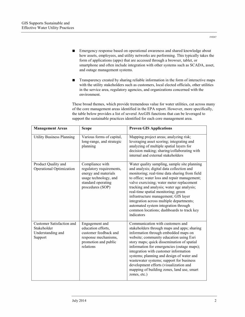
These broad themes, which provide tremendous value for water utilities, cut across many of the core management areas identified in the EPA report. However, more specifically, the table below provides a list of several ArcGIS functions that can be leveraged to support the sustainable practices identified for each core management area.
Management Areas Scope Proven GIS Applications
Utility Business Planning Various forms of capital, long-range, and strategic planning
Mapping project areas; analyzing risk; leveraging asset scoring; integrating and analyzing of multiple spatial layers for decision making; sharing/collaborating with internal and external stakeholders
Product Quality and Operational Optimization
Compliance with regulatory requirements, energy and materials usage technology, and standard operating procedures (SOP)
Water quality sampling, sample site planning and analysis; digital data collection and monitoring; real-time data sharing from field to office; water loss and repair management; valve exercising; water meter replacement tracking and analysis; water age analysis; real-time spatial monitoring; green infrastructure management; GIS layer integration across multiple departments; automated system integration through common locations; dashboards to track key indicators
Customer Satisfaction and Stakeholder Understanding and Support
Engagement and education efforts, customer feedback and response mechanisms, promotion and public relations
Communication with customers and stakeholders through maps and apps; sharing information through embedded maps on website; community education using Esri story maps; quick dissemination of spatial information for emergencies (outage maps); integration with customer information systems; planning and design of water and wastewater systems; support for business development efforts (visualization and mapping of building zones, land use, smart zones, etc.)
GIS Supports Sustainable and Effective Water Utility Practices
J10267
Esri White Paper 3
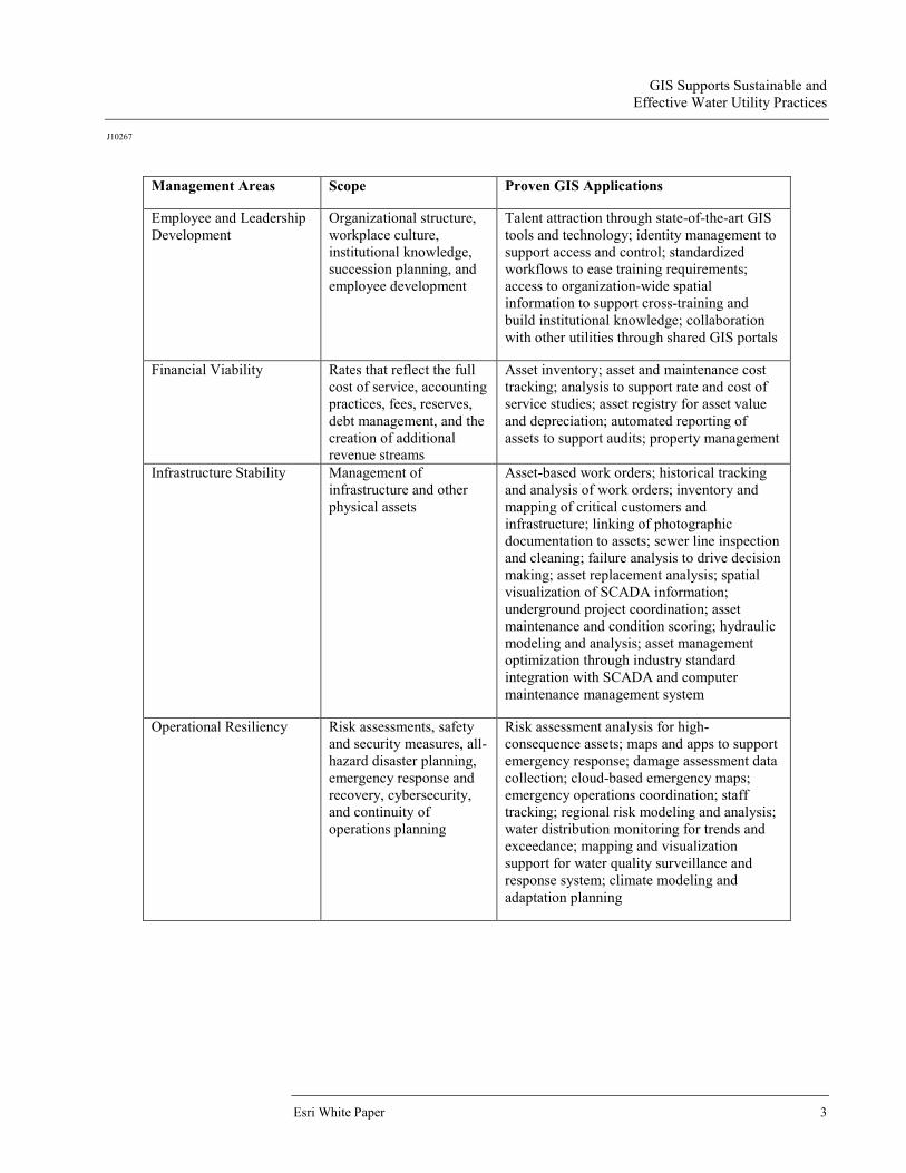
Management Areas Scope Proven GIS Applications
Employee and Leadership Development
Organizational structure, workplace culture, institutional knowledge, succession planning, and employee development
Talent attraction through state-of-the-art GIS tools and technology; identity management to support access and control; standardized workflows to ease training requirements; access to organization-wide spatial information to support cross-training and build institutional knowledge; collaboration with other utilities through shared GIS portals
Financial Viability Rates that reflect the full cost of service, accounting practices, fees, reserves, debt management, and the creation of additional revenue streams
Asset inventory; asset and maintenance cost tracking; analysis to support rate and cost of service studies; asset registry for asset value and depreciation; automated reporting of assets to support audits; property management
Infrastructure Stability Management of infrastructure and other physical assets
Asset-based work orders; historical tracking and analysis of work orders; inventory and mapping of critical customers and infrastructure; linking of photographic documentation to assets; sewer line inspection and cleaning; failure analysis to drive decision making; asset replacement analysis; spatial visualization of SCADA information; underground project coordination; asset maintenance and condition scoring; hydraulic modeling and analysis; asset management optimization through industry standard integration with SCADA and computer maintenance management system
Operational Resiliency Risk assessments, safety and security measures, all-hazard disaster planning, emergency response and recovery, cybersecurity, and continuity of operations planning
Risk assessment analysis for high-consequence assets; maps and apps to support emergency response; damage assessment data collection; cloud-based emergency maps; emergency operations coordination; staff tracking; regional risk modeling and analysis; water distribution monitoring for trends and exceedance; mapping and visualization support for water quality surveillance and response system; climate modeling and adaptation planning
GIS Supports Sustainable and Effective Water Utility Practices
J10267
July 2014 4
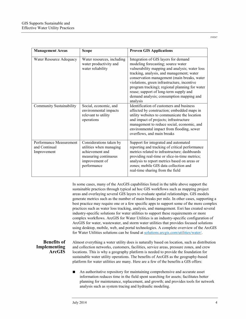
Management Areas Scope Proven GIS Applications
Water Resource Adequacy Water resources, including water productivity and water reliability
Integration of GIS layers for demand modeling forecasting; source water vulnerability mapping and analysis; water loss tracking, analysis, and management; water conservation management (main breaks, water violations, green infrastructure, incentive program tracking); regional planning for water reuse; support of long-term supply and demand analysis; consumption mapping and analysis
Community Sustainability Social, economic, and environmental impacts relevant to utility operations
Identification of customers and business affected by construction; embedded maps in utility websites to communicate the location and impact of projects; infrastructure management to reduce social, economic, and environmental impact from flooding, sewer overflows, and main breaks
Performance Measurement and Continual Improvement
Considerations taken by utilities when managing achievement and measuring continuous improvement of performance
Support for integrated and automated reporting and tracking of critical performance metrics related to infrastructure; dashboards providing real-time or slice-in-time metrics; analysis to report metrics based on areas or zones; mobile GIS data collection and real-time sharing from the field
In some cases, many of the ArcGIS capabilities listed in the table above support the sustainable practices through typical ad hoc GIS workflows such as mapping project areas and overlaying several GIS layers to evaluate spatial relationships. GIS models generate metrics such as the number of main breaks per mile. In other cases, supporting a best practice may require one or a few specific apps to support some of the more complex practices such as water loss tracking, analysis, and management. Esri has created several industry-specific solutions for water utilities to support these requirements or more complex workflows. ArcGIS for Water Utilities is an industry-specific configuration of ArcGIS for water, wastewater, and storm water utilities that provides focused solutions using desktop, mobile, web, and portal technologies. A complete overview of the ArcGIS for Water Utilities solutions can be found at solutions.arcgis.com/utilities/water/.
Benefits of Implementing
ArcGIS
Almost everything a water utility does is naturally based on location, such as distribution and collection networks, customers, facilities, service areas, pressure zones, and crew locations. This is why a geography platform is needed to provide the foundation for sustainable water utility operations. The benefits of ArcGIS as the geography-based platform for water utilities are many. Here are a few of the benefits a GIS offers: ■ An authoritative repository for maintaining comprehensive and accurate asset
information reduces time in the field spent searching for assets; facilitates better planning for maintenance, replacement, and growth; and provides tools for network analysis such as system tracing and hydraulic modeling.

GIS Supports Sustainable and Effective Water Utility Practices
J10267
Esri White Paper 5
■ Field GIS results in a more productive work force, reduces travel time and costs, increases the dynamic interaction of workflows, and provides real-time information flow between the field and the office.
■ Web GIS that integrates information from multiple sources into intuitive maps. It provides single, comprehensive views of the utility in the form of maps and dashboards. Web GIS applications can be leveraged within many other business systems.
■ Portal technology that opens access to geospatial data to everyone in the utility. This allows them to collaborate with contractors and other agencies. People across the department can discover, use, make, and share maps on any device, anywhere, anytime.
In today's environment of aging infrastructure, an aging work force, increasing regulations, and transparency requirements of the communities served, achieving sustainable water and wastewater services requires a geography-based platform. Esri platform technology enables everyone in the water utility to access the information they need and provides a means to collaborate with other employees regarding the location and status of assets, staff, and customers. ArcGIS transforms a water utility into a more informed, efficient, fiscally responsible, and transparent organization.

Printed in USA
Contact Esri
380 New York Street Redlands, California 92373-8100 usa
1 800 447 9778 t 909 793 2853 f 909 793 5953 [email protected] esri.com
Offices worldwide esri.com/locations
Esri inspires and enables people to positively impact their future through a deeper, geographic understanding of the changing world around them.
Governments, industry leaders, academics, and nongovernmental
organizations trust us to connect them with the analytic knowledge
they need to make the critical decisions that shape the planet. For
more than 40 years, Esri has cultivated collaborative relationships
with partners who share our commitment to solving earth’s most
pressing challenges with geographic expertise and rational resolve.
Today, we believe that geography is at the heart of a more resilient
and sustainable future. Creating responsible products and solutions
drives our passion for improving quality of life everywhere.


![GIS FOR SUSTAINABLE DEVELOPMENT [E-BOOK]achamad.staff.ipb.ac.id/wp-content/plugins/as-pdf...Title: kaswanto's blog Author: Regan Kaswanto kaswanto@ipb.ac.id Subject: GIS FOR SUSTAINABLE](https://img.dokumen.tips/doc/110x75/5f051c497e708231d41150e2/gis-for-sustainable-development-e-book-title-kaswantos-blog-author-regan.jpg)


