Embed Size (px)
Citation preview
Geospatial Techniques in Water Distribution Network Mapping and Modelling in Warri Port Complex (Nigeria)
(7663)
Henry Agbomemeh Audu and Odeh Jacob Ehiorobo (Nigeria)
FIG Working Week 2015
From the Wisdom of the Ages to the Challenges of the Modern World
Sofia, Bulgaria, 17-21 May 2015
1/14
Geospatial Techniques in Water Distribution Network Mapping and
Modelling in Warri Port Complex (Nigeria)
Henry Agbomemeh AUDU and Jacob Odeh EHIOROBO, Nigeria
Keywords: Geographic Information, Water Distribution System, Differential Global
Positioning System (DGPS), GPS Controls
SUMMARY
A well planned and adequately mapped water distribution network plays an immense
role in the provision of potable water supply. A good water distribution system is fundamental
to environmentally sustainable development in any country and is also important in the
control of water borne diseases.
In this study, the use of Global Positioning System (GPS), Total Station Instrument in
combination with Remote Sensing imagery in developing Warri port complex water supply
network is discussed. In order to carry out the acquisition of geospatial data for the water
infrastructure development, control points were established within the port complex by the
method of Differential GPS survey. These control points were used in running secondary total
station traverses through the proposed water distribution pipeline routes. The total station
survey was carried out at millimetre (mm) level accuracy to capture break in slopes while
support levels were run between the total station traverse routes. The processed geospatial
data were input into Microsoft Excel software, and script files were created. The script files
were exported into 3D Civil CAD from where vector models were generated. The distribution
layout vector plan was exported into the topographical model generated from the satellite
imagery. The geospatial database was exported into Haestad Water CAD environment for the
water distribution network analysis and design.
The output of the study was the water distribution network with the position of air
valves, sluice valves, wash out, end caps, fire hydrants etc. located. The interpretation of the
geospatial database with analytical tools allowed the water distribution network to be planned
more economically and effectively.
Geospatial Techniques in Water Distribution Network Mapping and Modelling in Warri Port Complex (Nigeria)
(7663)
Henry Agbomemeh Audu and Odeh Jacob Ehiorobo (Nigeria)
FIG Working Week 2015
From the Wisdom of the Ages to the Challenges of the Modern World
Sofia, Bulgaria, 17-21 May 2015
2/14
1.0 INTRODUCTION
Water is vital for man’s existence and without it, there would be no life on earth. As a
resource to any nation, it should be well planned, developed, conserved, distributed and
managed. Its infrastructure should be properly maintained to avoid future water problems.
The total water requirement is on the increase and the per capita water consumption is
also on the increase due to the increase in population and civilization(Al- layla et al,
1978; Audu and Anyata, 2010; Audu and Ehiorobo, 2010; Audu and Edokpia, 2010). Under
the most optimistic scenario, the world’s population is expected to grow from more than six
billion in 2000 to at least eight billion by 2025. This growth, 90 percent of which will occur
in urban areas will intensify the demand for potable water and water of sufficient quality for
use in the industry and waste treatment (Lacquemanne, 2000).
In 2005, the Institution of Civil Engineer’s (ICE) Geo-spatial Engineering Board, United
Kingdom (UK), while examining “buried services in a conference, deliberated extensively on
the problems of location, identification and geo-spatial positioning of a wide range of buried
services such as water, sewers, gas, electricity, etc. The question from the Director of UK
Water Industry’s Research Body, Farrimond (2005), buttresses the fact that the location and
geospatial positioning of engineering infrastructure, which include water infrastructure, is not
only a major problem in developing countries but also in industrialized nations of the world.
Farrimond asked “can we do something today to make these assets easier to find in a hundred
years time?”
Cullen (2005) opined that “a modern society has been victim of its own success. A
higher quality of life has meant greater demands on our services as people use more water and
burn more energy. Data collection and distribution, however, has not moved on”. The
challenges are: securing adequate and potable water for people, securing water for food,
protecting the ecosystems, creating awareness among the financing water infrastructure.
These challenges have continued to demand innovation and state- of- the- art technology
needed for drastic changes in the location, planning, collection, distribution and management
of water infrastructure (Cullen, 2005; Audu and Ehiorobo, 2010; Audu and Ukeme, 2013).
The technological advancement in the nation (Nigeria), which has led to tremendous growth
in water distribution system, has not been translated to improved water supply as private
boreholes with little or no treatment abound, water borne diseases are on the increase and low
pressures are evident in many states of the nation (Izinyon, 2007).
The aim and objectives of this study are to examine the location of NPA water
distribution pipeline routes; determine the geo-spatial information required for the planning
and design of a comprehensive NPA water distribution network and to produce the vector
models of the water infrastructure.
2.0 WATER DISTRIBUTION SYSTEM
Although the size and complexity of water distribution system (WDS) may vary
dramatically, they all have the same basic purpose, to deliver water from the source (or
treatment facility) to the consumer (Beecher, 2000). The source of water commonly
determines the nature of collection, purification, transmission and distribution works.
Common sources are rainwater, surface water and ground water. A water distribution system
consists of a complex network of interconnected pipes, services, reservoirs, hydrants and
Geospatial Techniques in Water Distribution Network Mapping and Modelling in Warri Port Complex (Nigeria)
(7663)
Henry Agbomemeh Audu and Odeh Jacob Ehiorobo (Nigeria)
FIG Working Week 2015
From the Wisdom of the Ages to the Challenges of the Modern World
Sofia, Bulgaria, 17-21 May 2015
3/14
other appurtenances including valves and flow meters which deliver water from the treatment
plant to the consumer (Chadwick and Morfett, 1993; Nathanson, 1997; Walski et al. 2003 and
Izinyon, 2007).
The distribution components form a large proportion of total investment in any water
supply system (Rao, 2002). Water distribution system account for 40-70% of the total cost of
water supply scheme (Sarbu and Borza, 1997; Nathanson, 1997 and Izinyon, 2007), hence its
proper planning, design, operation and layout is of great importance. Water distribution
network contains all the various components of a water system and defines how the
components are interconnected. These components include water reservoir, water pipes, water
pumps, storage tanks, junctions and valves. According to Lansey and Mays (2000), a water
distribution system consists of three major components: distribution piping network, pumps
and distribution storage. The components of water distribution system and their modelling
purposes are shown in Table 1.
Adequate water supply and distribution systems are not only fundamental to
environmentally sustainable development in any country but also are important in the control
of many water borne and water related – diseases such as cholera, diarrhoea, typhoid and
para–typhoid fever, hepatitis, etc.
Table 1- Components of Water Distribution System and Modelling purposes (Walski et
al, 2003)
Component Type of Network
Modelling Element
Primary modelling purpose
Reservoir Node Provides water to the system
Pipe Link Conveys water from one node to another
Pump Node Raises the hydraulic grade to overcome
elevation differences and friction losses.
Storage Tank Node Stores excess water within the system and
releases that water at times of high usage.
Junction Node Removes (demand) or adds (inflow) water
from/to the system.
Valve Node or Link Controls flow or pressure in the system
based on specified criteria
Geospatial Techniques in Water Distribution Network Mapping and Modelling in Warri Port Complex (Nigeria)
(7663)
Henry Agbomemeh Audu and Odeh Jacob Ehiorobo (Nigeria)
FIG Working Week 2015
From the Wisdom of the Ages to the Challenges of the Modern World
Sofia, Bulgaria, 17-21 May 2015
4/14
2.1 Geo-spatial Information in Water Distribution System
A network of pipes, pumps, valves and other appurtenances are required to move
water from the source to the consumer (Walski et al, 2003). Water distribution components
form a large proportion of total investment in any water supply system (Rao, 2002). These
components include water reservoir, water pipes, water pumps, storage tanks, junctions and
valves. Douglas et al.(1995) reported that a pipe, which conveys the flow of water from one
point to another in a pipeline network, is the primary water distribution network component.
The principal characteristics of pipe are the pipe material, length, diameter and pipe carrying
capacity factor (C- factor). Water pipeline systems need some periodic inspection for effective
performance of the system.
Research has shown that more than 80% of all information can be geographically
referenced (Dangermond, 1999). Parker (1996) on the other hand showed that about 85% of
all information has some spatial contents. The role of Geo-spatial analysis cannot be
overestimated as a determining factor in today’s policy making for a better world; it must
form the basis of any strategy for economic development of a region (Haarsma, 2008). Geo-
spatial information is the basic ingredient for the physical planning, design and development
of infrastructure (Ehiorobo and Audu, 2007). Geo-spatial information, which exists in real
world in terms of space (with location) and time, can be represented in the form of maps,
databases and statistical representation (Akinyede and Borroffice, 2004). Coordinates are geo-
spatial information used to represent the location of natural or man -made features on the
earth‘s surface. They are set of values that define a position within a spatial reference (ESRI,
2000). Geo-spatial information plays a significant role in the planning, design, location and
maintenance management of water distribution infrastructure (WDI). Furthermore, most
components of water infrastructure are referenced to the surface of the earth (Audu and
Ehiorobo, 2010).
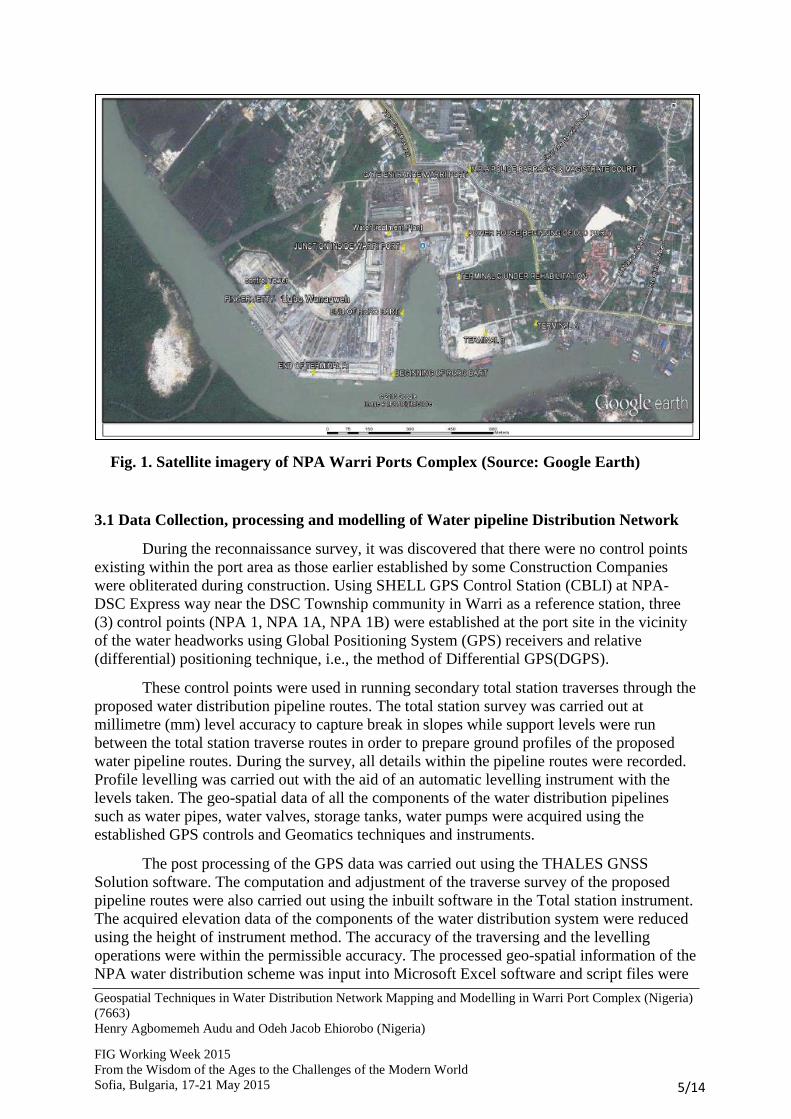
3.0 THE STUDY AREA
The study area is situated at Warri Ports Complex of the Nigerian Ports Authority, Warri, in
Warri South Local Government Area of Delta State, Nigeria. It lies within the tropical
rainforest zone and is bounded by National Coordinates 16700mN to 16850mN and
361500mE to 367000mE. The port complex occupies an area of about 120 Hectares and the
main jetty is about 1.94km long. Existing facilities at the port include Administrative
buildings; Finger Jetty; Terminals A, B, and C; Control Tower; Fire Service Station;
Magistrate Court; Religious Centres (Church and Mosque); etc. The satellite imagery of the
study area, which was used during reconnaissance survey and had assisted in locating
important features within the port area is shown in Fig. 1.
Geospatial Techniques in Water Distribution Network Mapping and Modelling in Warri Port Complex (Nigeria)
(7663)
Henry Agbomemeh Audu and Odeh Jacob Ehiorobo (Nigeria)
FIG Working Week 2015
From the Wisdom of the Ages to the Challenges of the Modern World
Sofia, Bulgaria, 17-21 May 2015
5/14
Fig. 1. Satellite imagery of NPA Warri Ports Complex (Source: Google Earth)
3.1 Data Collection, processing and modelling of Water pipeline Distribution Network
During the reconnaissance survey, it was discovered that there were no control points
existing within the port area as those earlier established by some Construction Companies
were obliterated during construction. Using SHELL GPS Control Station (CBLI) at NPA-
DSC Express way near the DSC Township community in Warri as a reference station, three
(3) control points (NPA 1, NPA 1A, NPA 1B) were established at the port site in the vicinity
of the water headworks using Global Positioning System (GPS) receivers and relative
(differential) positioning technique, i.e., the method of Differential GPS(DGPS).
These control points were used in running secondary total station traverses through the
proposed water distribution pipeline routes. The total station survey was carried out at
millimetre (mm) level accuracy to capture break in slopes while support levels were run
between the total station traverse routes in order to prepare ground profiles of the proposed
water pipeline routes. During the survey, all details within the pipeline routes were recorded.
Profile levelling was carried out with the aid of an automatic levelling instrument with the
levels taken. The geo-spatial data of all the components of the water distribution pipelines
such as water pipes, water valves, storage tanks, water pumps were acquired using the
established GPS controls and Geomatics techniques and instruments.
The post processing of the GPS data was carried out using the THALES GNSS
Solution software. The computation and adjustment of the traverse survey of the proposed
pipeline routes were also carried out using the inbuilt software in the Total station instrument.
The acquired elevation data of the components of the water distribution system were reduced
using the height of instrument method. The accuracy of the traversing and the levelling
operations were within the permissible accuracy. The processed geo-spatial information of the
NPA water distribution scheme was input into Microsoft Excel software and script files were

Geospatial Techniques in Water Distribution Network Mapping and Modelling in Warri Port Complex (Nigeria)
(7663)
Henry Agbomemeh Audu and Odeh Jacob Ehiorobo (Nigeria)
FIG Working Week 2015
From the Wisdom of the Ages to the Challenges of the Modern World
Sofia, Bulgaria, 17-21 May 2015
6/14
created. The script files were exported into AutoCAD 3D Civil software, where the geo-
spatial information of the various components of WDN, were modelled in the CAD software
as vector models. The distribution layout vector plan was exported into the topographical
model generated from the satellite imagery. The geospatial database, which was designed and
created, was exported into Haestad Water CAD environment for the water distribution
network analysis.
The water distribution network analysis using the Haestad water CAD was based on
traverse lines representing length of pipes, intersection points as well as grow elevation
obtained from DEM generated from the topo-map and from ground levelling. Analysis of
DEM database with the Haedstad CAD was used to determine where pressures are low and
head losses high.
These were used to identify if pipe sizes were adequate or not for delivering the required flow
rates to various section of the port.
4.0 RESULTS AND DISCUSSION
4.1 Results
The WGS 84 coordinates of the GPS reference station and the established GPS
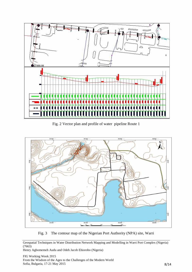
Controls at NPA site are presented in Table 2. The plan and profile for the pipeline route 1 is
presented in Fig. 2. Table 3 shows the Geo-spatial Information and the Estimated Borehole
Capacity in the Study Area. The Attribute information of the components of NPA Water
Transmission and Distribution pipelines are presented in Table 4. The contour map of the
study area is shown in Fig. 3.
Table 2 WGS 84 Coordinates of the GPS Reference stations in Minna Datum and
Established Controls at NPA site
Station ID East (m) North (m) Height (orthometric) (m)
CBL 1 376 194.180 166 859.940 4.270
NPA 1 366 330.062 168 055.404 3.008
NPA 1A 366 238.369 168 133.840 2.589
NPA 1B 366 441.071 168 058.694 2.440
Geospatial Techniques in Water Distribution Network Mapping and Modelling in Warri Port Complex (Nigeria)
(7663)
Henry Agbomemeh Audu and Odeh Jacob Ehiorobo (Nigeria)
FIG Working Week 2015
From the Wisdom of the Ages to the Challenges of the Modern World
Sofia, Bulgaria, 17-21 May 2015
7/14
Table 3 Geo-spatial Information and the Estimated Borehole Capacity in the Study Area
Borehole
(BH)
Service
Area
Coordinates Status/Proposed
work Proposed
Yield
(m3/hr)
Proposed
Yield
(m3/day)
Easting
(m)
Northing
(m)
BH1 New Port 366 097.259 168050.883 NF/Reactivation 70 m3/hr
1400
m3/day
BH2 New Port 366 033.392 168029.223 NF/Reactivation 70 m3/hr
1400
m3/day
BH3 New Port 366 455.782 167 992.213 NF/Reactivation
70 m3/hr
1400
m3/day
BH4 New Port
(Standby) 366 027.041 168139.879
New Construction 70 m
3/hr
1400
m3/day
BH5 Old Port
(Standby) 366 767.493 167 493.883
New Construction 70 m
3/hr
1400
m3/day
NF –Not functioning
Table 4 Attribute information of the components of NPA Water Transmission and
Distribution pipelines
System
Component
Pipe Material Pipe Diameter Hazen –
Williams factor
(C )
Deign Period
(years)
Transmission
pipes
uPVC 200mm 140-150 30
Distribution
Pipes
uPVC 250mm (Mains
200mm (Sub- mains)
140-150 30
Distribution
system
Appurtenance
Gate values, Endcap, Washout valves, Air relief valves, Water metres and
Hydrants
Geospatial Techniques in Water Distribution Network Mapping and Modelling in Warri Port Complex (Nigeria)
(7663)
Henry Agbomemeh Audu and Odeh Jacob Ehiorobo (Nigeria)
FIG Working Week 2015
From the Wisdom of the Ages to the Challenges of the Modern World
Sofia, Bulgaria, 17-21 May 2015
8/14
Fig. 2 Vector plan and profile of water pipeline Route 1
Fig. 3 The contour map of the Nigerian Port Authority (NPA) site, Warri
Geospatial Techniques in Water Distribution Network Mapping and Modelling in Warri Port Complex (Nigeria)
(7663)
Henry Agbomemeh Audu and Odeh Jacob Ehiorobo (Nigeria)
FIG Working Week 2015
From the Wisdom of the Ages to the Challenges of the Modern World
Sofia, Bulgaria, 17-21 May 2015
9/14
4.2 Discussion
This study has established three GPS controls (NPA1, NPA IA, NPA IB) (Table 2) in
the study area. These controls provided the needed control stations for the traverse and
detailed survey of the water pipeline routes at Warri NPA site. Besides, they shall be used as
reliable control points for future survey works within the study area and its environs.
Establishment of controls, where none exists, is in accordance with survey principles when
carrying out any survey work. Controls are survey points, survey stations, reference
monuments of known coordinates whose positions and elevations in relation to their origin
are known and other survey work of lesser quality and accuracy are related to them. The
practice of using control framework as a basis for further survey operations is often called
‘working from whole to the part’. It prevents the accumulation of errors in any survey work.
The commonest system of control is by coordinates- planimetric coordinates for the
horizontal controls and height recording from an adopted datum for the vertical controls
(Scofield and Breach, 2007).
The rectangular coordinates, shown in Table 2, played significant roles in the location
and geo-spatially positioning of the entire water distribution network of the study area.
Besides, the various components of NPA water distribution system can be planned, designed,
constructed and maintained on the basis of the computerised information, which includes
coordinates as well as other information concerning topography, geology, drainage,
population inter alia. According to Audu and Ehiorobo (2010), most engineering
infrastructure such as waterlines, railways, highways, buildings, dams and powerlines located
on, beneath or above the surface of the earth are spatial objects. The most convenient and
most used method of describing their positions is by their rectangular coordinates
(McCormac, 2004).
The remotely sensed data, the digital satellite imagery (Fig.1), acquired during this
study, has provided reliable, up-to-date information of the study area and aided in determining
the most desirable and economic location of the NPA water distribution pipelines.
The vector plans and profiles for the NPA water pipeline routes (Fig.2) were used in
the preparation of the estimates for the construction of the water distribution system and the
tender for the contractors. They are part of the tender documents that provide valuable
information for the bidders as well as form a reference manual for use during the execution of
the project. The plans are the drawings that contain all details necessary for proper
construction of the water distribution network, while the vertical alignment sometimes
referred to as profile indicate the natural ground surface and the centre line of the water
infrastructure with details of the vertical curves. The profile also helps in computing the
estimated earthwork quantities. Nicholas and Lester (1999) noted that “plans, profiles and
specifications are part of the contract documents for the construction of water distribution
system, highways, railways etc. They are therefore considered as legal documents in the
construction industry. Furthermore, they are used for the preparation of the construction’s
estimates and the contractor’s bids.”
Terrain elevations, shown in Fig.3, play major roles in the distribution and flow of
water in the natural landscape of the study area. Moreover, they contribute immensely in the
determination of the actual location of NPA ground level storage reservoir and the elevated
storage tank. The ground elevations are very useful when evaluating the hydraulic grades and
Geospatial Techniques in Water Distribution Network Mapping and Modelling in Warri Port Complex (Nigeria)
(7663)
Henry Agbomemeh Audu and Odeh Jacob Ehiorobo (Nigeria)
FIG Working Week 2015
From the Wisdom of the Ages to the Challenges of the Modern World
Sofia, Bulgaria, 17-21 May 2015
10/14
operating elevations within the pressure systems. The produced contour map and the profile
levels were used for the pipeline network design.
As the existing boreholes have been non-functional for a long period (more than 7
years), it is proposed that the boreholes (BH1, BH2 and BH3) should be rehabilitated,
reactivated and equipped to bring them to maximum yield shown in Table 3. Moreso, this
study has proposed that two additional boreholes (BH4 and BH5), with one suitably located in
the New Port area and the other in the Old Port area, should be constructed to serve as buffer
and standby for the existing boreholes. The estimated borehole capacities are given in Table
3.
The design period, the pipe materials, pipe carrying capacity and the pipe diameter for
both the transmission and distribution pipelines are presented in Table 4. Unplasticised
Polyvinyl Chloride (uPVC) pipes were proposed for the transmission and distribution
pipelines because they are nowadays not only most preferred pipe materials for water supply
piping but also due to their strength and resistance to internal pressure; are not subject to
corrosion or deterioration by electrolysis, chemicals or biological activities; are exceptionally
smooth, minimizing friction losses in water flow. Furthermore, they are lightweight, very
smooth surface finish, ease of installation and repair, and up to 150mm in diameter of the
pipes may be site-bent slightly to accommodate ground contours or changes in direction (Rao,
2002).
CONCLUSION
The importance of accurate and up-to-date geo-spatial information in the planning,
location, design and development of water distribution infrastructure has been highlighted.
This study has examined the use of a modern technology, Geo-spatial information and
Geomatics techniques in the planning and development of water distribution system of the
Nigerian Ports Authority.
The results of the study revealed that with the provision of accurate, up-to- date geo-
spatial information, the physical location of NPA water infrastructure on or beneath the
earth’s surface can be determined. Moreover, with the help of the modern geomatics
(surveying) techniques and state-of –the art instruments such as Electronic Total Station
(ETS), the Global Positioning System receivers and satellite remote sensors, regular updating
of the geo-spatial information of the components of the water systems in the study area can be
carried out. Since we live in a dynamic world with increasing population, urbanization and
industrialization, the geo-spatial information (the water distribution systems maps) should be
regularly updated using geomatics technology and equipment including Electronic Total
Station (ETS), GNSS receivers, or satellite remote sensors.
Geospatial Techniques in Water Distribution Network Mapping and Modelling in Warri Port Complex (Nigeria)
(7663)
Henry Agbomemeh Audu and Odeh Jacob Ehiorobo (Nigeria)
FIG Working Week 2015
From the Wisdom of the Ages to the Challenges of the Modern World
Sofia, Bulgaria, 17-21 May 2015
11/14
REFERENCES
Al-layla, M.A., Ahmad, S., and Middlebrooks, E. J. (1978). “Water Supply Engineering
Design.” Michigan, Ann Arbor Science Publishers
Akinyede, J.O. and Boroffice, T. (2004), “Geoinformation, Space Applications and
Sustainable National Development”, Nigerian Journal of Surveying and
Geoinformatics.”, Lagos,Vol.1 pp17- 40.
Audu, H.A.P. and Anyata, B.U.(2010), “Water Quality Surveillance in Niger Delta Region of
Nigeria”, Technical Transaction, Journal of the Nigerian Institution of Production
Engineers, Benin City, Vol. 12, pp 80 – 90.
Audu, H.A.P. and Ehiorobo, J. O. (2010), “Location and Geospatial Positioning of Water
Distribution Infrastructure in GIS Environment”, Technical Transaction, Journal of the
Nigerian Institution of Production Engineers, Benin City, Vol. 12 (2010), pp 65-79.
Audu, H.A.P. and Edokpia, R.O. (2010), “Planning and Maintenance Management of Water
Distribution System with Geo-spatial Information System”, Journal of Engineering for
Development, Benin City, Vol. 9, pp 142-154
Audu, H.A.P. and Ukeme, U. (2013), “Geo- spatial information for the location and
maintenance management of water service pipelines”, Journal of Advanced Materials
Research, Zurich, Switzerland, Vol 824, pp 634-642.
Cullen, T. (2005), “ Geomatics World” Contribution of the expert to the one-day event
organized by the Institution of Civil Engineers, Geo-spatial Engineering Board,
London, Vol. 13 No 5, pp 21-23.
Dangermond, J. (1999), “The Geographic Information Officer comes of Age”, London, pp
30-31.
Douglas, J.F.; Gasiorek, J.M. and Swaffield, J.M. (1995), “Fluid Mechanics”, third edition,
London, Pitman Publishing Ltd.
Ehiorobo, J.O. and Audu, H.A.P, (2007), “Developing the Niger Delta Transport System
Using Adequate Geo-Spatial Information: Journal of Advanced Materials Research,
Zurich, Switzerland, Vol 18 and 19, pp. 365-372.
Environmental System Research Institute (ESRI) (2000), “Manual on Arcview GIS”.
Redland USA, ESRI Press
Farrimond, M. (2005), “Geomatics world”, Contribution of the expert to the one-day event
organized by the Institution of Civil Engineers, Geo-spatial Engineering Board United
Geospatial Techniques in Water Distribution Network Mapping and Modelling in Warri Port Complex (Nigeria)
(7663)
Henry Agbomemeh Audu and Odeh Jacob Ehiorobo (Nigeria)
FIG Working Week 2015
From the Wisdom of the Ages to the Challenges of the Modern World
Sofia, Bulgaria, 17-21 May 2015
12/14
Kingdom, UK, July/August 2005, Issue No 5, Vol. 13.
Haarsma, D. (2008), “Geo-economics” The Global Magazine for Geomatics(GIM)
International, Netherland, Vol. 22, Issue 6.
Izinyon, O.C. (2007), “Hydraulic Performance evaluation of Urban Water Supply
system” Unpublished PhD Thesis, Department of Civil Engineering, University of
Benin.
Lacquemanne, O. (2000), “Integrated approach key to ground water management”. Water
and Wastewater International Magazine, Vol. 16, Issue 4, pp. 10-15.
McCormac, J. (2004), “Surveying”, 5th
Edition, Published by John Wiley and son, USA
Parker, D. (1996), “An introduction to GIS and the impact on Civil Engineering”,
Proceedings of the Institution of Civil Engineers on Geographic Information
Systems, London, pp 3-11.
Rao, V. P. (2002), “Environmental Engineering”, 1st edition, New Delhi, India, Published by
Prentice hall Ltd
Sarbu, I. and Borza, I (1997), “Optimal design of water distribution networks”, Journal of
Hydraulic research. Vol. 35 issue 1, pp 63-69
Schofield, W. and Breach, M. (2007), Engineering Surveying, Sixth Edition, United Kingdom
Published by Elsevier Limited
Walski, T.M., Chase, D.V., Savic, D.A., Grayman, W., Beckwith, and Koelle.E. (2003),
“Advanced Water Distribution Modelling and Management”, First Edition, CT USA,
Haestad Press Waterbury
Geospatial Techniques in Water Distribution Network Mapping and Modelling in Warri Port Complex (Nigeria)
(7663)
Henry Agbomemeh Audu and Odeh Jacob Ehiorobo (Nigeria)
FIG Working Week 2015
From the Wisdom of the Ages to the Challenges of the Modern World
Sofia, Bulgaria, 17-21 May 2015
13/14
BIOGRAPHICAL NOTES
Audu Henry Agbomemeh is a senior lecturer and Head of Department of Geomatics,
University of Benin where he teaches Engineering Surveying, Remote Sensing and GIS,
Engineering Mathematics, Technical Communication and CAD and Solid Waste
Management.
He obtained an MSc(Eng) in Surveying Engineering degree from Sofia, Bulgaria in 1995 and
a PhD in Geomatics Engineering from University of Benin in 2010. He has won various
awards, co-authored and reviewed several academic papers. His research interest includes
Engineering and Construction survey, GIS in water resources and Environmental modelling
and management, land information management and disaster management. He is registered
with Surveyors Council of Nigeria (SURCON) and a member of the Nigerian Institution of
Surveyors (NIS) and the Nigerian Institute of Management (NIM).
Jacob Odeh Ehiorobo is a Professor and Dean of Faculty of Environmental Sciences,
University of Benin; where he teaches Engineering Mathematics, Engineering Surveying,
Applied Geodesy, Highway Engineering and Automatic Vehicle Location (AVL), Remote
Sensing and GIS.
He obtained an Msc Surveying Engineering degree from MIIGAIK, Moscow in 1983, Ph.D
Geomatics Engineering from the University of Benin in 2008. He is a consultant on various
infrastructural development project, Environmental Monitoring and Management as well in
the Oil and Gas Industry in Nigeria.
His research interest include; Deformation Surveys and Analysis, Engineering and
Construction Surveys, GIS, Remote Sensing and LIM, Water Resources Modelling and
Management as well as Environmental Hazard Monitoring and Analysis. He is a member of
the Editorial board in several research Journals and have over sixty (60) published articles in
both local and international journals and a reviewer for several local and international
journals.
He is a fellow of the Nigerian Institution of Surveyors (FNIS), Member of the Nigerian
Society of Engineers (MNSE) and Member of the Nigeria Institution of Civil Engineers
(MNICE).

Geospatial Techniques in Water Distribution Network Mapping and Modelling in Warri Port Complex (Nigeria)
(7663)
Henry Agbomemeh Audu and Odeh Jacob Ehiorobo (Nigeria)
FIG Working Week 2015
From the Wisdom of the Ages to the Challenges of the Modern World
Sofia, Bulgaria, 17-21 May 2015
14/14
CONTACTS:
Henry Agbomemeh AUDU, Nigeria
Faculty of Environmental Sciences and Technology
Department of Geomatics
University of Benin,
Benin City,
Edo State, Nigeria
Tel: +2348066855914
Email: [email protected]
Prof. Jacob O. Ehiorobo
Dean’s office,
Faculty of Environmental Sciences,
University of Benin.
PMB 1154, Benin City, Edo State, Nigeria
Tel. Mobile: +2348032217426, +2348023373844
E-mail: [email protected]


![[Zhenjiang Shen] Geospatial Techniques in Urban Planning](https://img.dokumen.tips/doc/110x75/5695d0811a28ab9b0292b824/zhenjiang-shen-geospatial-techniques-in-urban-planning.jpg)