Embed Size (px)
Citation preview
MINISTRY OF PUBLIC WORKS AND PUBLIC HOUSING
GEOSPATIAL DATA FOR SUPPORTING
SPATIAL PLANNING AND INFRASTRUCTURE
DEVELOPMENT
Head of Central for Data Processing
Asian Geospatial Forum
Jakarta, 26th November 2014
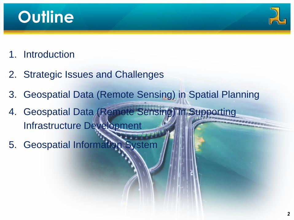
Outline
1. Introduction
2. Strategic Issues and Challenges
3. Geospatial Data (Remote Sensing) in Spatial Planning
4. Geospatial Data (Remote Sensing) in Supporting
Infrastructure Development
5. Geospatial Information System
2

Introduction
33
1
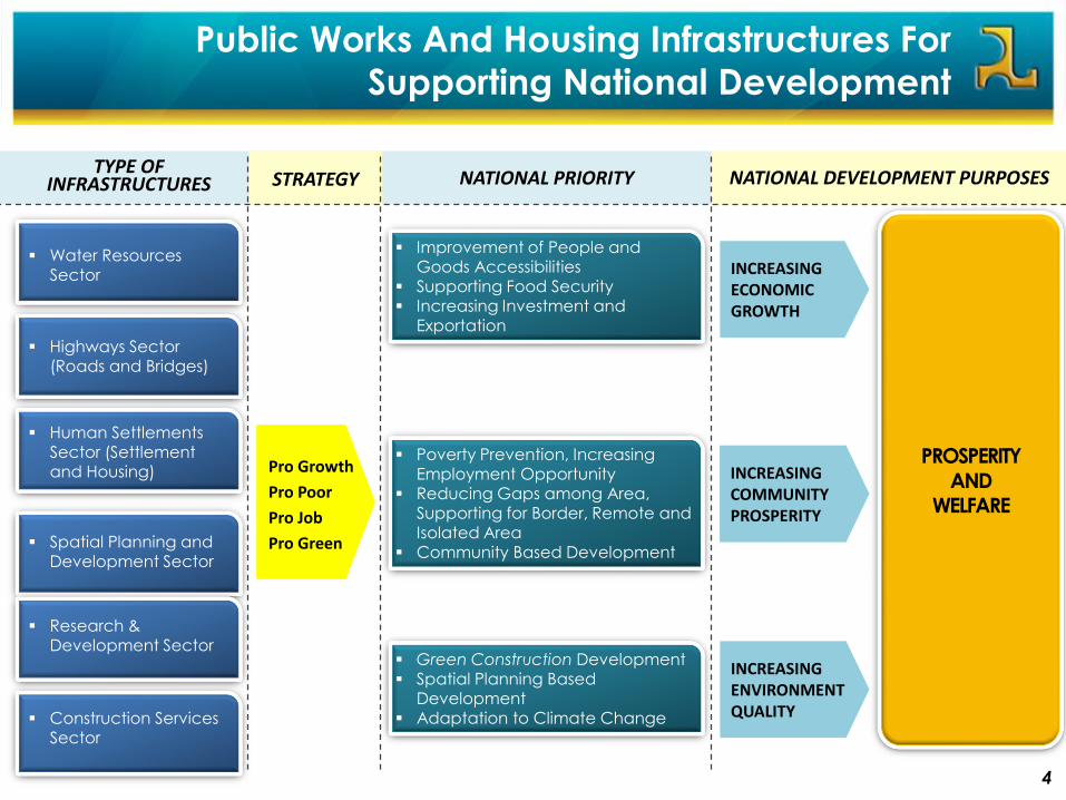
Public Works And Housing Infrastructures For
Supporting National Development
4
Pro Growth
Pro Poor
Pro Job
Pro Green
Poverty Prevention, Increasing Employment Opportunity
Reducing Gaps among Area, Supporting for Border, Remote and Isolated Area
Community Based Development
Improvement of People and Goods Accessibilities
Supporting Food Security Increasing Investment and
Exportation
Green Construction Development Spatial Planning Based
Development Adaptation to Climate Change
PROSPERITY AND
WELFARE
INCREASING ECONOMIC GROWTH
INCREASING ENVIRONMENT QUALITY
INCREASING COMMUNITY PROSPERITY
TYPE OF INFRASTRUCTURES STRATEGY NATIONAL PRIORITY NATIONAL DEVELOPMENT PURPOSES
Water Resources Sector
Highways Sector
(Roads and Bridges)
Spatial Planning and Development Sector
Research & Development Sector
Construction Services Sector
Human Settlements Sector (Settlement and Housing)
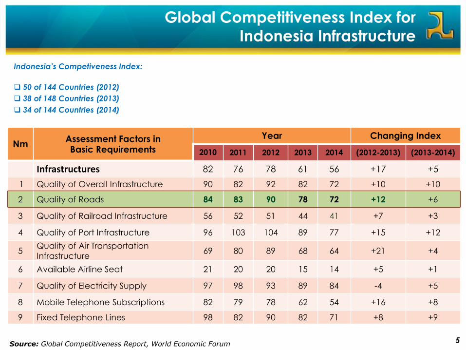
Global Competitiveness Index for
Indonesia Infrastructure
NmAssessment Factors in Basic Requirements
Year Changing Index
2010 2011 2012 2013 2014 (2012-2013) (2013-2014)
Infrastructures 82 76 78 61 56 +17 +5
1 Quality of Overall Infrastructure 90 82 92 82 72 +10 +10
2 Quality of Roads 84 83 90 78 72 +12 +6
3 Quality of Railroad Infrastructure 56 52 51 44 41 +7 +3
4 Quality of Port Infrastructure 96 103 104 89 77 +15 +12
5Quality of Air Transportation
Infrastructure69 80 89 68 64 +21 +4
6 Available Airline Seat 21 20 20 15 14 +5 +1
7 Quality of Electricity Supply 97 98 93 89 84 -4 +5
8 Mobile Telephone Subscriptions 82 79 78 62 54 +16 +8
9 Fixed Telephone Lines 98 82 90 82 71 +8 +9
Source: Global Competitiveness Report, World Economic Forum
Indonesia’s Competiveness Index:
50 of 144 Countries (2012)
38 of 148 Countries (2013)
34 of 144 Countries (2014)
5
Strategic Issues & Challenges
6
2
6
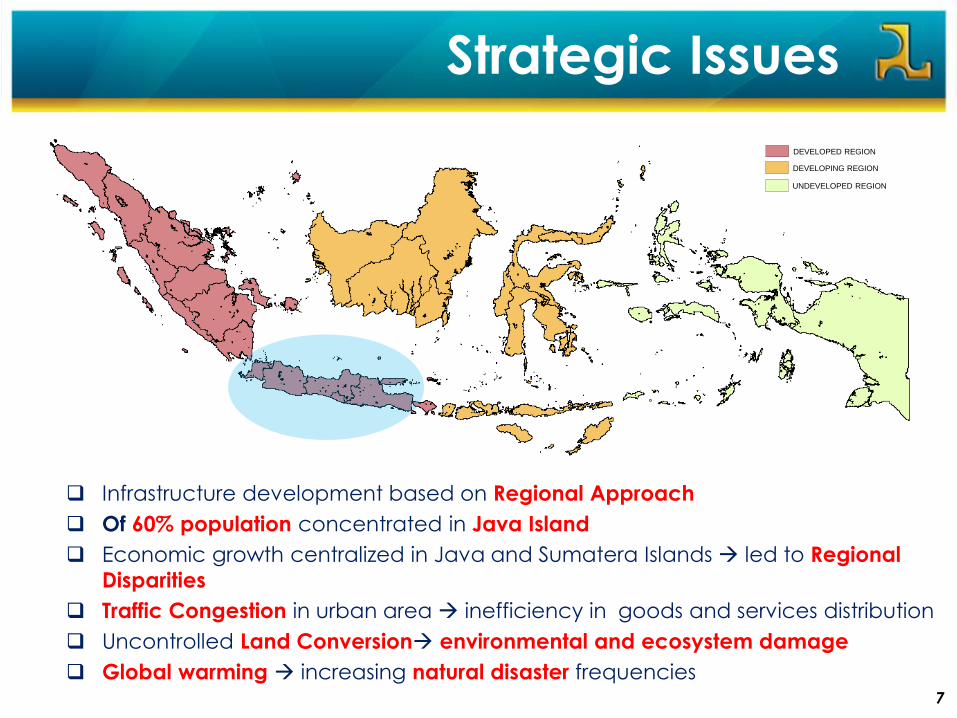
Strategic Issues
DEVELOPING REGION
UNDEVELOPED REGION
DEVELOPED REGION
Infrastructure development based on Regional Approach
Of 60% population concentrated in Java Island
Economic growth centralized in Java and Sumatera Islands led to Regional
Disparities
Traffic Congestion in urban area inefficiency in goods and services distribution
Uncontrolled Land Conversion environmental and ecosystem damage
Global warming increasing natural disaster frequencies7
Challenges
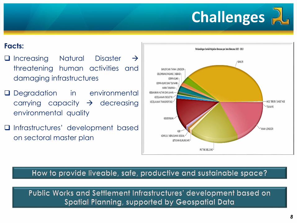
8
Facts:
Increasing Natural Disaster
threatening human activities and
damaging infrastructures
Degradation in environmental
carrying capacity decreasing
environmental quality
Infrastructures’ development based
on sectoral master plan
Geospatial Data In Spatial Planning
99
3
10
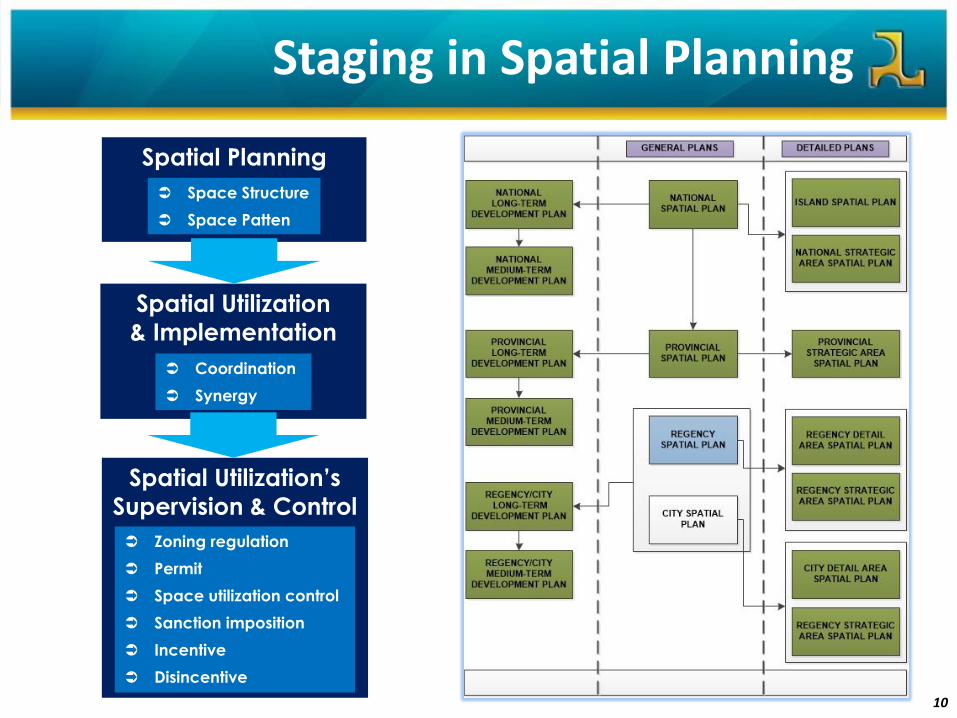
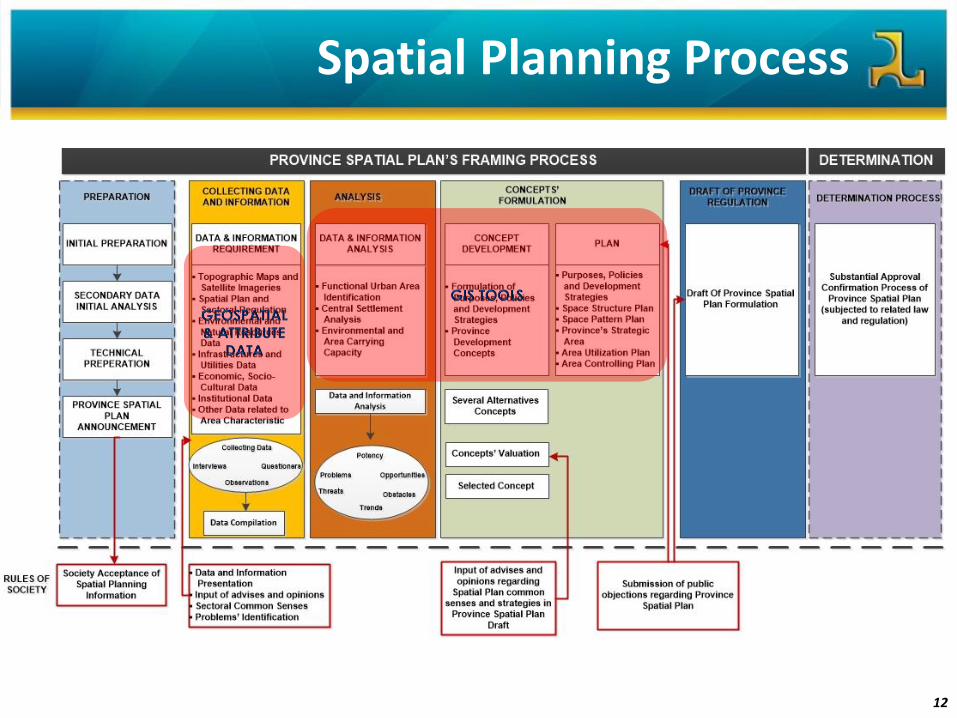
Staging in Spatial Planning
Spatial Planning
Spatial Utilization
& Implementation
Spatial Utilization’s
Supervision & Control
Zoning regulation
Permit
Space utilization control
Sanction imposition
Incentive
Disincentive
Coordination
Synergy
Space Structure
Space Patten
11
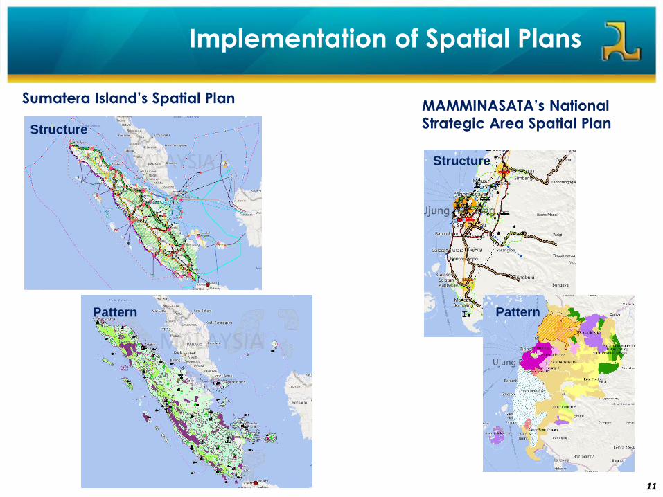
Sumatera Island’s Spatial PlanMAMMINASATA’s National
Strategic Area Spatial PlanStructure
Structure
Pattern Pattern
Implementation of Spatial Plans
12
Spatial Planning Process
13
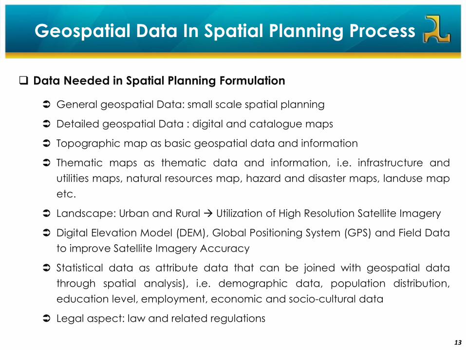
Geospatial Data In Spatial Planning Process
Data Needed in Spatial Planning Formulation
General geospatial Data: small scale spatial planning
Detailed geospatial Data : digital and catalogue maps
Topographic map as basic geospatial data and information
Thematic maps as thematic data and information, i.e. infrastructure and
utilities maps, natural resources map, hazard and disaster maps, landuse map
etc.
Landscape: Urban and Rural Utilization of High Resolution Satellite Imagery
Digital Elevation Model (DEM), Global Positioning System (GPS) and Field Data
to improve Satellite Imagery Accuracy
Statistical data as attribute data that can be joined with geospatial data
through spatial analysis), i.e. demographic data, population distribution,
education level, employment, economic and socio-cultural data
Legal aspect: law and related regulations

14
Geospatial Analysis in Spatial Planning Process
Spatial Analysis
Economical Aspect Analysis is intended to identify potensial location, natural and humanresources as well as human made resources in order to be economically maximized forachieving robust economic growth as well as social welfare, that led to increasinginvestment grade and fund mobilization.
Physical and environmental aspects analysis is intended to identify the characteristic of
natural resources by exploring land capability and land availability in order tooptimization land use and enviroment sustainability.
Socio-cultural aspect analysis is inteded to identify socio cultural structure and its impactto achieve sustainable natural resources utilization for social welfare improvement
GIS Tools:
Basic Tools
Spatial Analysis
Geospatial Analysis
Network Analysis
Layout
15
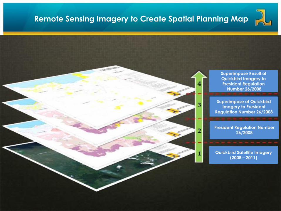
Remote Sensing Imagery to Create Spatial Planning Map
Quickbird Satellite Imagery (2008 – 2011)
President Regulation Number 26/2008
Superimpose of QuickbirdImagery to President
Regulation Number 26/2008
Superimpose Result of Quickbird Imagery to President Regulation
Number 26/2008
16
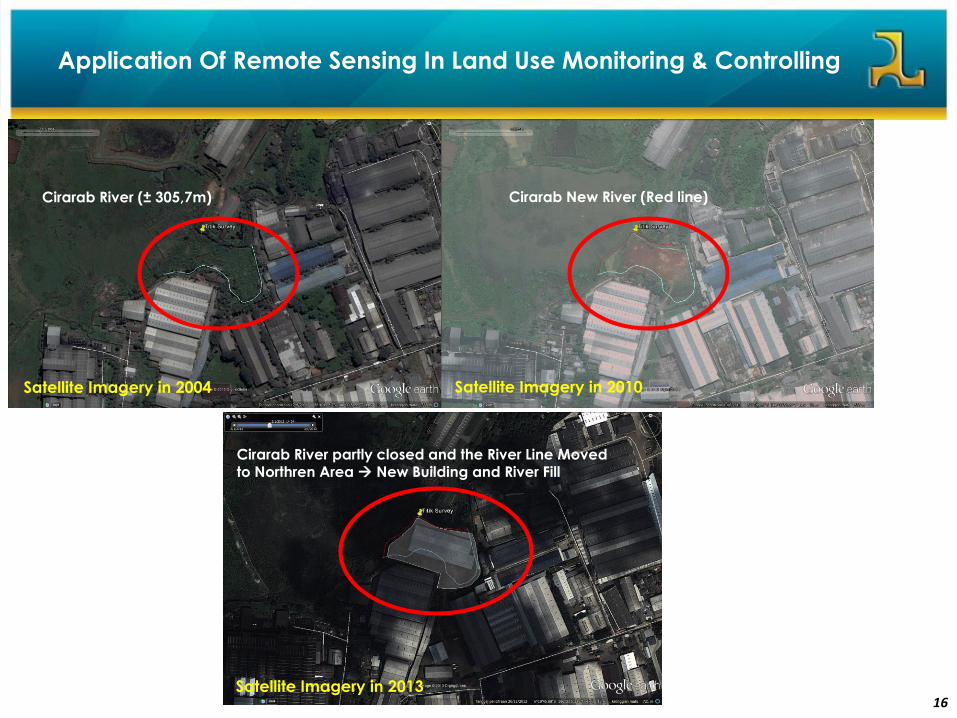
Satellite Imagery in 2004
Sudah terbentuk sungai baru
Cirarab River partly closed and the River Line Moved to Northren Area New Building and River Fill
Satellite Imagery in 2010
Cirarab River (± 305,7m) Cirarab New River (Red line)
Application Of Remote Sensing In Land Use Monitoring & Controlling
Satellite Imagery in 2013
17
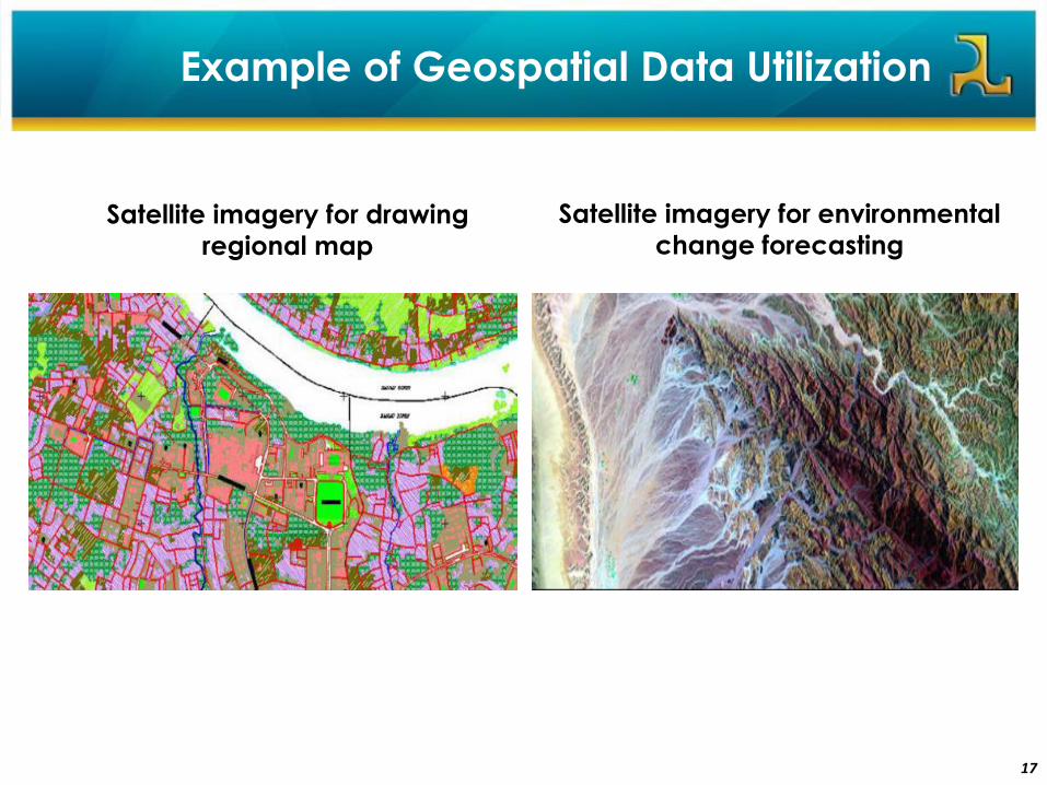
Satellite imagery for drawing
regional map
Satellite imagery for environmental
change forecasting
Example of Geospatial Data Utilization
Remote Sensing Technology
In Supporting Infrastructure Development
1818
5
19
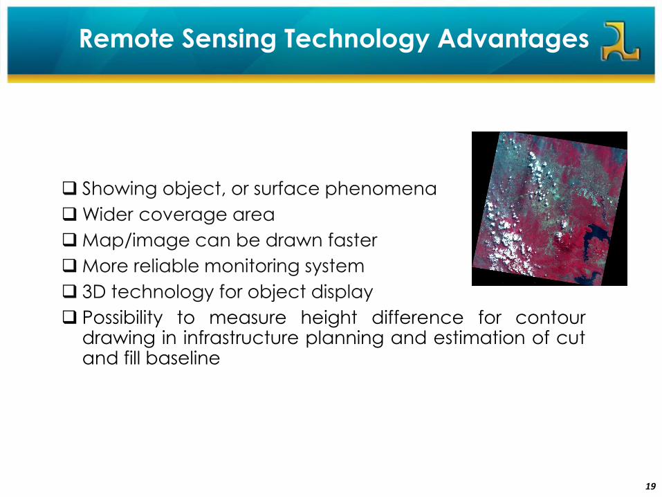
Showing object, or surface phenomena
Wider coverage area
Map/image can be drawn faster
More reliable monitoring system
3D technology for object display
Possibility to measure height difference for contourdrawing in infrastructure planning and estimation of cutand fill baseline
Remote Sensing Technology Advantages
20
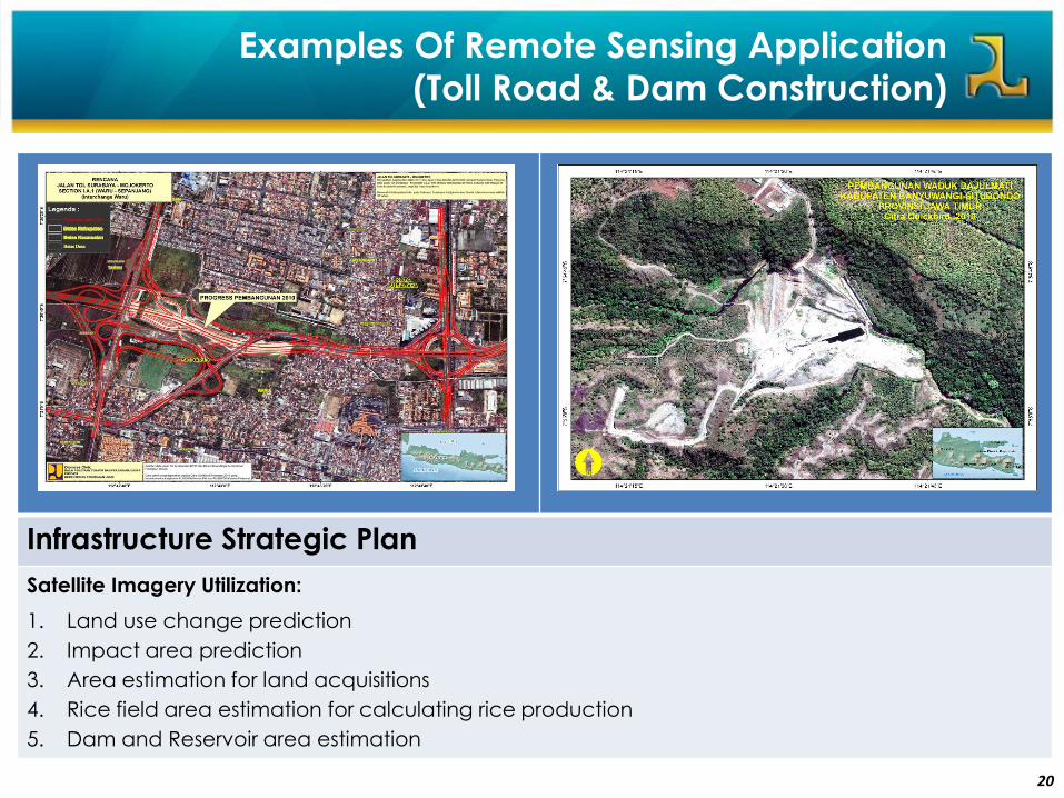
Infrastructure Strategic Plan
Satellite Imagery Utilization:
1. Land use change prediction
2. Impact area prediction
3. Area estimation for land acquisitions
4. Rice field area estimation for calculating rice production
5. Dam and Reservoir area estimation
Examples Of Remote Sensing Application
(Toll Road & Dam Construction)

21
Settlement Land Use Pattern
Cultivation Area
River & River Basin Management
Disaster Prone Area
UAV PUSDATA Collection
Small Format Aerial Photo of Citarum’s Catchment Area Scale 1:5.000
Small Format Aerial Photo of Ciliwung’s Catchment Area Scale 1:5.000
UAV Benefit
Efficient
Implementable in urban & rural area
High Resolution
3D Modelling
Examples Of Remote Sensing Application
(River Basin Management)
Small Format Aerial Photo
22
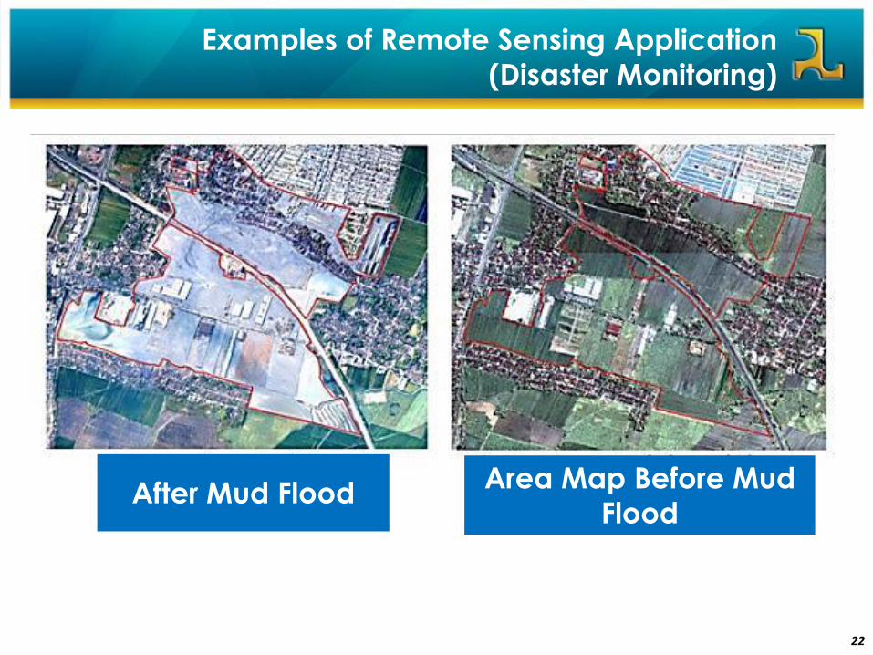
Examples of Remote Sensing Application
(Disaster Monitoring)
After Mud FloodArea Map Before Mud
Flood
23
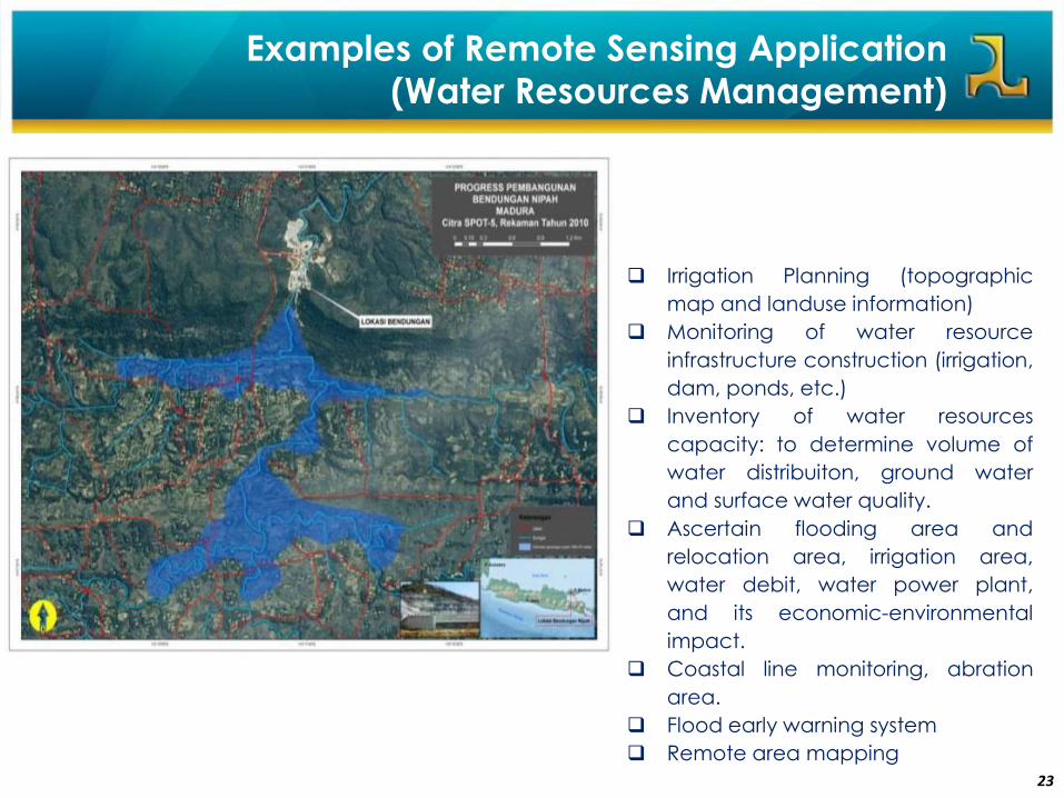
Irrigation Planning (topographic
map and landuse information)
Monitoring of water resource
infrastructure construction (irrigation,
dam, ponds, etc.)
Inventory of water resources
capacity: to determine volume of
water distribuiton, ground water
and surface water quality.
Ascertain flooding area and
relocation area, irrigation area,
water debit, water power plant,
and its economic-environmental
impact.
Coastal line monitoring, abration
area.
Flood early warning system
Remote area mapping
Examples of Remote Sensing Application
(Water Resources Management)
24
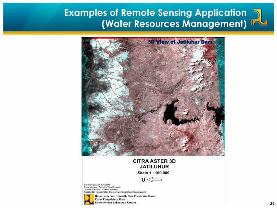
Examples of Remote Sensing Application
(Water Resources Management)
3D View of Jatiluhur Dam
25
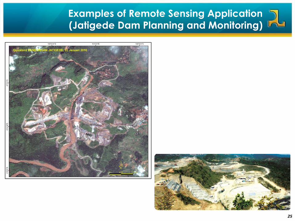
Examples of Remote Sensing Application
(Jatigede Dam Planning and Monitoring)
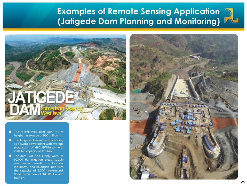
26
Examples of Remote Sensing Application
(Jatigede Dam Planning and Monitoring)
27
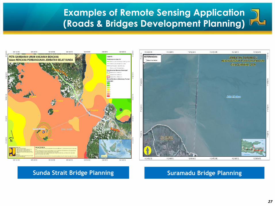
Sunda Strait Bridge Planning
Examples of Remote Sensing Application
(Roads & Bridges Development Planning)
Suramadu Bridge Planning
28
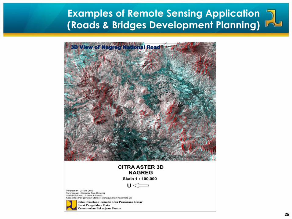
3D View of Nagreg National Road
Examples of Remote Sensing Application
(Roads & Bridges Development Planning)
29
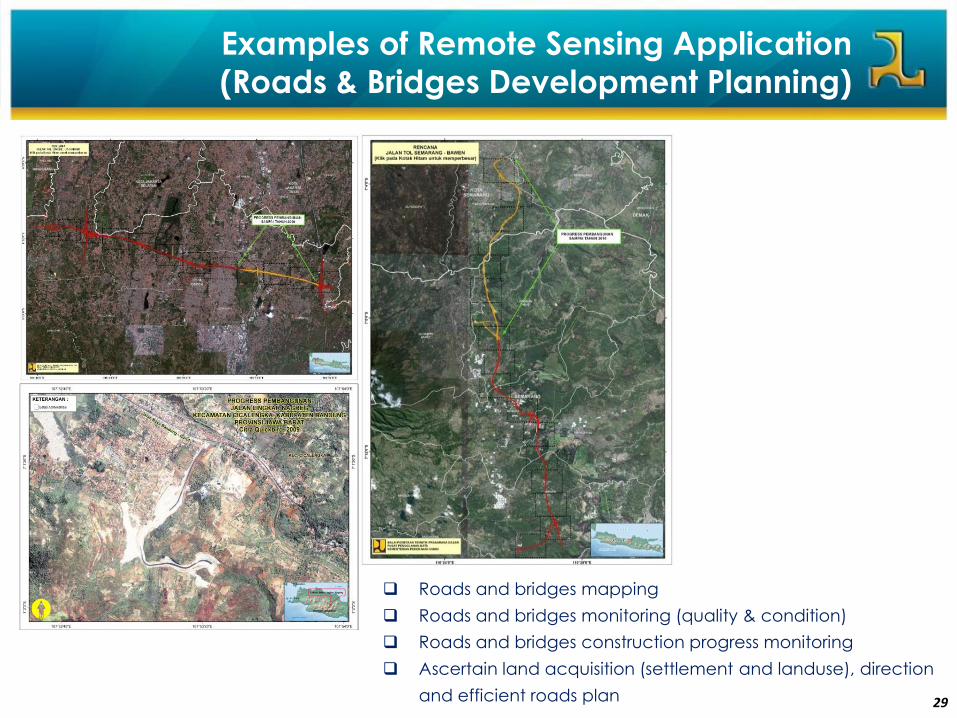
Roads and bridges mapping
Roads and bridges monitoring (quality & condition)
Roads and bridges construction progress monitoring
Ascertain land acquisition (settlement and landuse), direction
and efficient roads plan
Examples of Remote Sensing Application
(Roads & Bridges Development Planning)
30
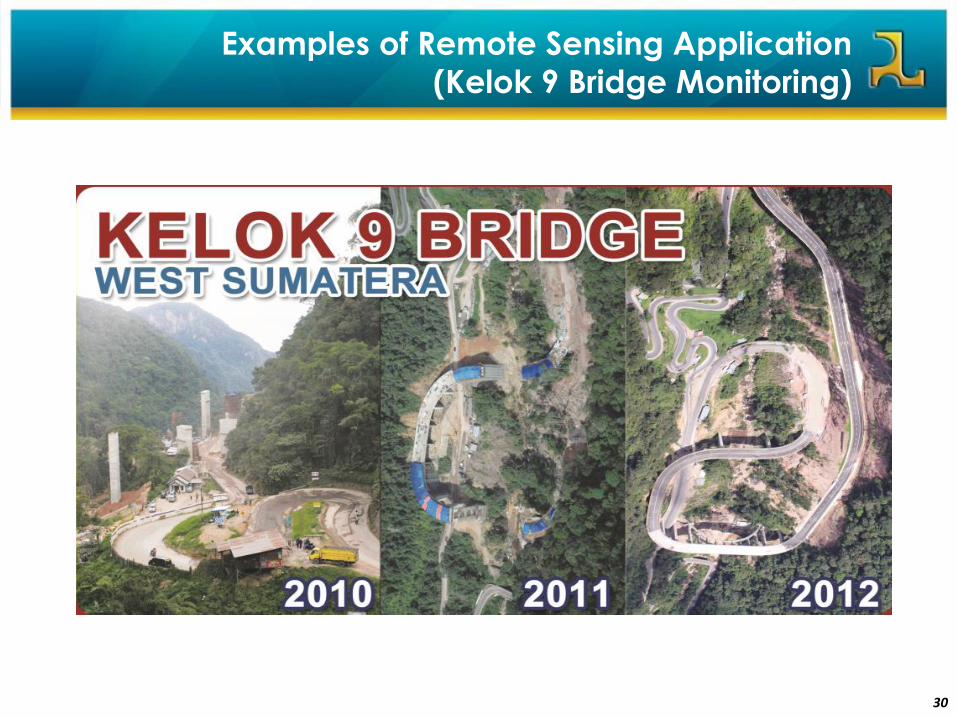
Examples of Remote Sensing Application
(Kelok 9 Bridge Monitoring)
31
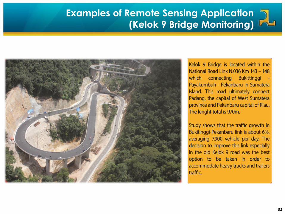
Examples of Remote Sensing Application
(Kelok 9 Bridge Monitoring)
32
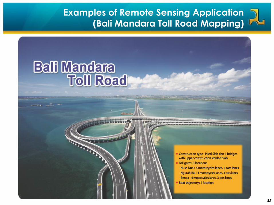
Examples of Remote Sensing Application
(Bali Mandara Toll Road Mapping)
33
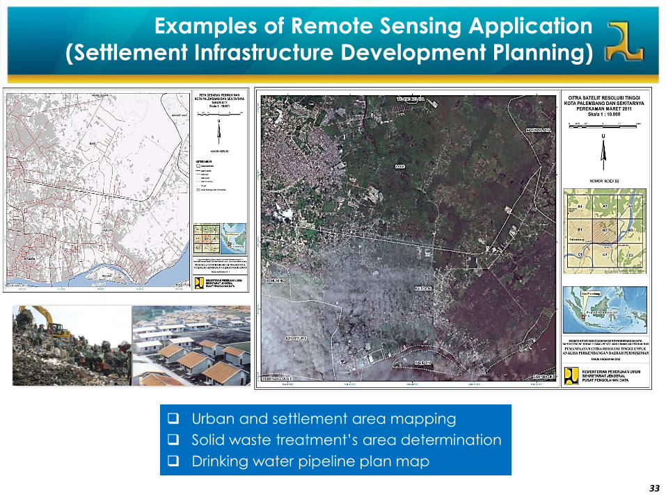
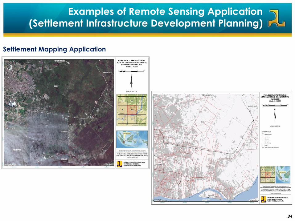
Urban and settlement area mapping
Solid waste treatment’s area determination
Drinking water pipeline plan map
Examples of Remote Sensing Application
(Settlement Infrastructure Development Planning)
34
Settlement Mapping Application
Examples of Remote Sensing Application
(Settlement Infrastructure Development Planning)

35
Examples of Remote Sensing Application
(DSDP Planning and Monitoring)
3636
6Map Information System in Ministry of Public
Works (Center for Data Processing)
37
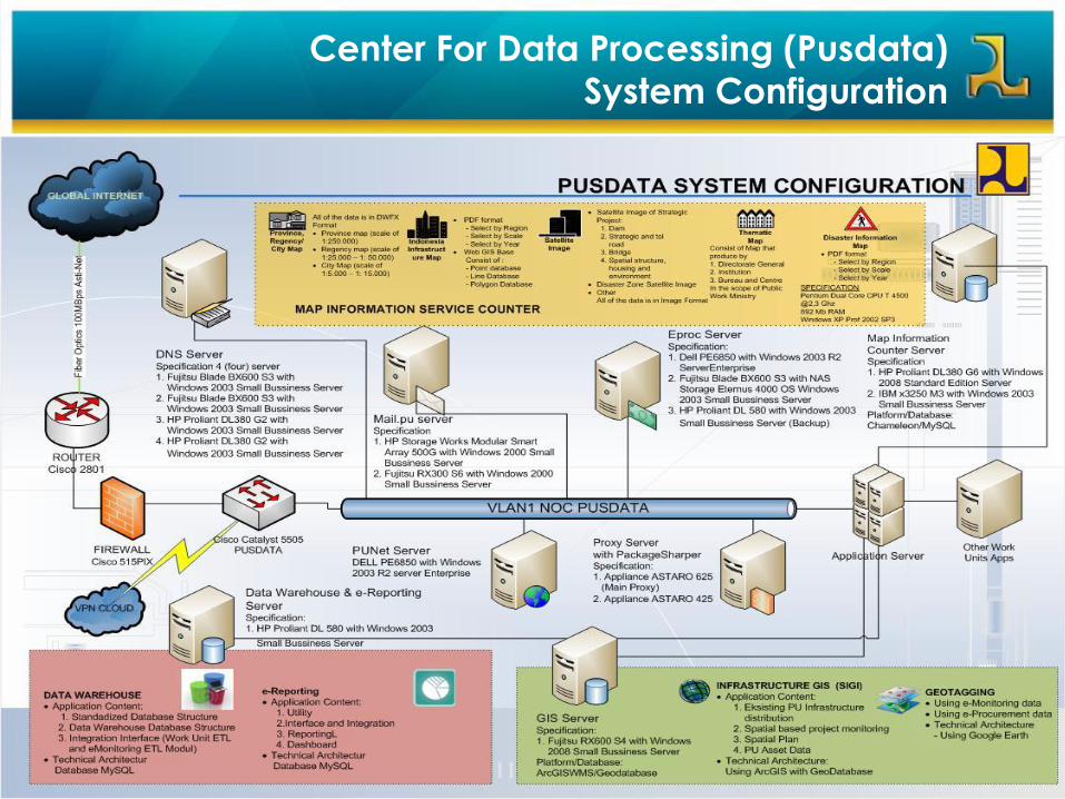
Center For Data Processing (Pusdata)
System Configuration
38
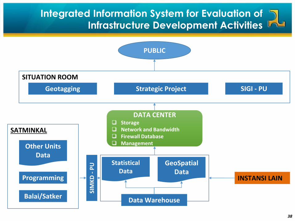
Integrated Information System for Evaluation of
Infrastructure Development Activities
Geotagging Strategic Project
SITUATION ROOM
SIGI - PU
PUBLIC
Statistical Data
Data Warehouse
GeoSpatial Data
SIM
KD
-P
U
DATA CENTER Storage Network and Bandwidth Firewall Database Management
INSTANSI LAIN
Other Units Data
Programming
SATMINKAL
Balai/Satker
39
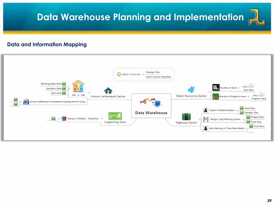
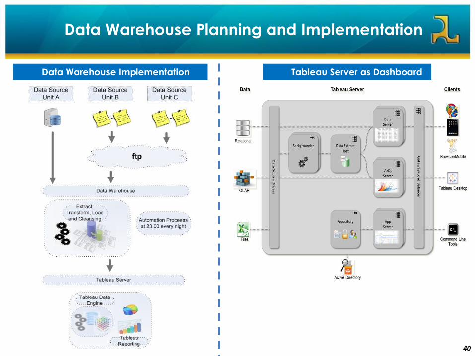
Data Warehouse Planning and Implementation
Data and Information Mapping
40
Tableau Server as DashboardData Warehouse Implementation
Data Warehouse Planning and Implementation
41
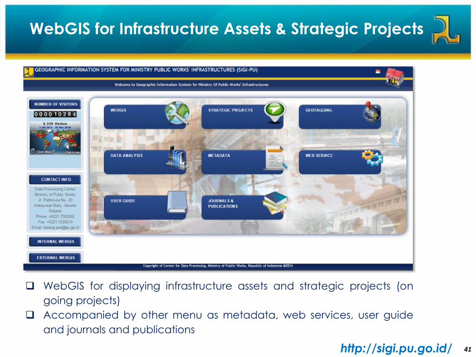
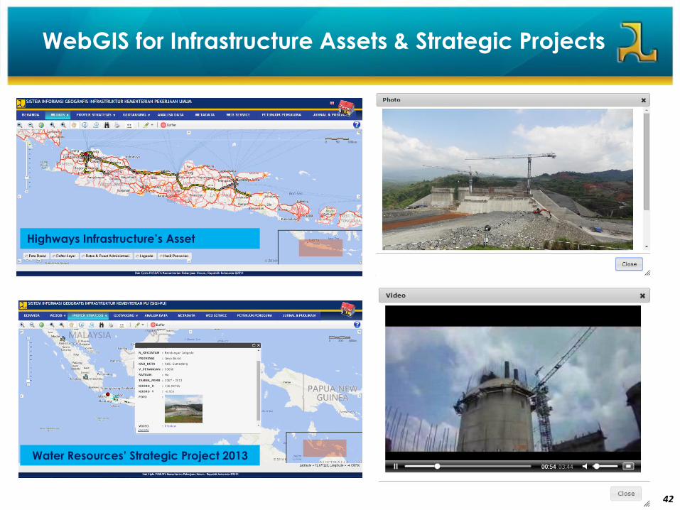
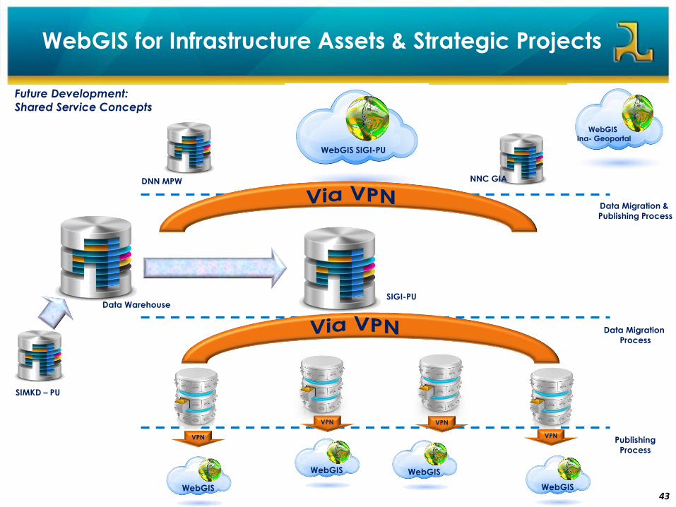
WebGIS for Infrastructure Assets & Strategic Projects
http://sigi.pu.go.id/
WebGIS for displaying infrastructure assets and strategic projects (on
going projects)
Accompanied by other menu as metadata, web services, user guide
and journals and publications
42
Water Resources’ Strategic Project 2013
WebGIS for Infrastructure Assets & Strategic Projects
Highways Infrastructure’s Asset
43
WebGIS for Infrastructure Assets & Strategic Projects
WebGIS SIGI-PU
VPN VPN
VPN
Future Development:
Shared Service Concepts
WebGIS
WebGIS
WebGIS
WebGIS
Data WarehouseSIGI-PU
DNN MPW
WebGIS Ina- Geoportal
SIMKD – PU
Data Migration
Process
VPN
Data Migration &
Publishing Process
NNC GIA
Publishing
Process
44
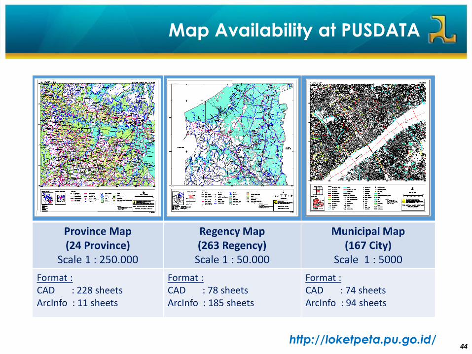
Map Availability at PUSDATA
• Peta Vektor
Province Map (24 Province)
Scale 1 : 250.000
Regency Map(263 Regency)
Scale 1 : 50.000
Municipal Map (167 City)
Scale 1 : 5000
Format :CAD : 228 sheetsArcInfo : 11 sheets
Format :CAD : 78 sheetsArcInfo : 185 sheets
Format :CAD : 74 sheetsArcInfo : 94 sheets
http://loketpeta.pu.go.id/

4545