Embed Size (px)
Citation preview
SCIENCE'S COMPASS
PERSPECTIVES: C E O S C I E N C E
Future of the West Antarctic or, the ice thickness has not changed much (5). Changes are also slight in East Antarc- tica. Around the perimeter, the most sea- ward ice has been lost because of rising
I Last Glacial Maximum (20,000 wars aaol I
'2
sea level. The only other major loss of East
Ice Sheet Antarctic ice is in the Lambert Glacier re- gion, where similar ungrounding formed
Robert Bindschadler the Amery Ice Shelf. New research provides "way points" in
T here has been much debate over what level 11 m (4). The largest losses have the retreat history of the West Antarctic Ice would happen if the West Antarctic Ice been where the former grounded ice sheet Sheet (see graph). Most of the data come Sheet were to collapse into the ocean. retreated, forming the present-day Ross from analyses of sediment cores from the
The economic and ecological impacts of the and RonneIFilchner Ice Shelves (see fig- western Ross Sea. Radiocarbon dating of the resulting 5-m increase in global sea level ure, panels C and D). Deeper in the interi- ice-front retreat chronology is most reliable, would depend greatly on the rate owing to the increase in biogenic at which this change might take
1 material deposited on the sea floor
place. Most attempts to quantify when ice retreat results in open the probability of a collapse have marine conditions (6). A multivari- been limited to assumptions of ate approach was used to date un- "quasi-randomness" of these grounding 1 1,700 years ago near events and the results of Monte Drygalski Ice Tongue (7). Some Carlo simulations (I). But recent 7 controversy on the fullest extent of information on past ice-sheet ex- the grounded ice sheet still exists, tent and current behavior are pro- - but the range of disagreement does viding another view of its future not affect my interpretation of the lifetime and its potential contri- data. Finally, terrestrial surface ex- bution to sea level. posure dates in the McMurdo
Concern over the West Ant- Sound area have been used to de- arctic Ice Sheet is based on the termine that grounded ice left that past episodes of rapid sea-level area 7000 years ago (8). rise and their correlation with These way points are com- rapid discharge of grounded ice bined by projecting them onto a within basins of former ice I flow line following ice stream sheets occupying marine basins. B and its corresponding trough West Antarctica is the most in the Ross Sea (9). Some cores prominent remaining ice-filled (KC37, KC3 1, PC26, PC29, marine basin on Earth. It i s and DfS0-117) lie westward of drained by fast-moving ice this flow line, in ice that may streams that extend far into the have originated in East Antarc- ice-sheet interior. Theoretical tica; however, large embay- analysis of such "marine-based" ments are absent in the present- ice sheets suggests that they are D‘ day ice front, and retreat was unstable (2). A model incorpo- probably roughly uniform across rating interaction between the b
1 the ice front. Along this flow
ice, subglacial water, and till al- line, the present termination of so exhibited periodic collapses - grounded ice is 700 km down- of the ice sheet (3). stream of the ice divide, and
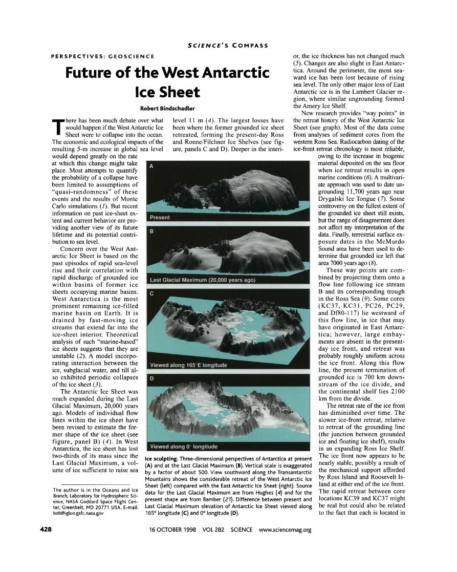
The Antarctic Ice Sheet was the continental shelf lies 2100 much expanded during the Last km from the divide. Glacial Maximum, 20,000 years The retreat rate of the ice front ago. Models of individual flow has diminished over time. The lines within the ice sheet have slower ice-front retreat, relative been revised to estimate the for- ' t to retreat of the grounding line mer shape of the ice sheet (see (the junction between grounded figure, panel B) (4). In West ice and floating ice shelf), results Antarctica, the ice sheet has lost - in an expanding Ross Ice Shelf. two-thirds of its mass since the Ice sculpting. Three-dimensional perspectives of Antarctica at present The ice front now appears to be Last Glacial Maximum, a vO1- (A) and at the Last Glacial Maximum (B). Vertical scale is exaggerated stable, possibly a result of ume of ice sufficient to raise sea by a factor of about 500, View southward along the Transantarctic the IIlechanical support afforded
Mountains shows the considerable retreat of the West Antarctic Ice Island and ROOsevelt Is- Sheet (Left) compared with the East Antarctic Ice Sheet (right). Source land at either end of the ice front.
The is in the Oceans and Ice data for the Last Glacial Maximum are from Hughes (4) and for the The rapid retreat between core Branch, Laboratory for Hydrospheric Sci- ence, NASA Goddard Space Flight Cen- present shape are from Bamber (27). Difference between present and locations KC39 and KC37 might ter, Greenbelt, MD 20771 USA. E-mail: Last Glacial Maximum elevation of Antarctic Ice Sheet viewed along be real bgt could also be related [email protected] 165" longitude (C) and 0" longitude (D). to the fact that each is located in
16 OCTOBER 1998 VOL 282 SCIENCE www.sciencemag.org

SCIENCE'S C O M P A S S
separate sea-bed troughs. Short-lived and the ocean must equal 2.3 mrnlyear of Consideration of past data near the ice asynchronous retreat along these troughs sea-level equivalent. This means the overall stream B flow line thus seems to provide cannot be ruled out. mass balance of the West Antarctic Ice bounds on the future lifetime of the West
A linear fit to the grounding-line retreat Sheet must be -53%. Ice stream B's mass Antarctic Ice Sheet of between 4000 and data implies an average rate of retreat of balance 1s -50% (Id), but other ice streams 7000 years. These bounds are qualified 100 dyear. At this rate, the grounding line have lower mass imbalances (although most by the ability of ice stream B to represent would reach the ice divide in another 7000 are negative). Ice streams feeding the the entire West Antarctic Ice Sheet; how- years, supplying a sustained contribution of Ronne Ice Shelf appear more stable than ever, the length of this flow line and the 0.8 mmlyear to rising sea level. This large amount of sea-floor sediment amount would reconcile the disagree- analysis in the western Ross Sea ment noted by Me~er (10) between the make it the best candidate for this ex- sum of present estimates of sea-level amination. The West Antarctic Ice contnbutions and observed rates if the Sheet has undergone much larger Antarctic Ice Sheet mass balance is changes than the adjacent East replaced by this West Antarctic value Antarctic Ice Sheet and has raised and if the Greenland Ice Sheet mass sea level 11 m over more than the balance is reduced to zero, according past 14,000 years at an average rate to recent re-analysis of satellite al- of 0.8 mmlyear. Grounding-line posi- timetry (I I). tions support a model of accelerating
A second-order fit to the ground- retreat, but the required overall mass ing-line retreat data results in an ac-
' balance in West Antarctica would
celerating retreat model. In this case, -maw need to be considerably more nega- the initial grounding-line position 1s A hasty retreat? Positions of grounding line (circles) and tive than can be confirmed from cur- ignored because both the date and po- ice front (triangles) in the western Ross Sea versus time rent data. Thus, a more erratic histo- s~tion are uncertain. This model, how- from present. Positions are projected onto a flow line fol- ry is still possible with a variable re- ever, predicts a 4000-year lifetime for lowing ice Stream B,WestAntarctica- Labels of ice-front Po- treat rate and a shorter lifetime. In- the ice sheet, a current retreat rate of Sitions denote cores collected in Sea (7). For- tervals of most dramatic change ap- 150 mlyear, and a current sea-level grounding-line Positions are from core Df80-177 near pear to coincide with episodes of contnbut~on of 1.3 mmlyear. Support Drygalski Ice Tongue (8) and in the vicinity of McMurdo rapid sea-level rise, but the cause- for these higher rates of retreat can be Sound (9). Positions at -14,000 years are estimates of posi- and-effect relation remains unclear. found from direct measurements at tions during the Last Glacial Maximum. Lines represent pos- More accurate prediction of the fu- the head of ice stream B. There, rates sible retreat behavior discussed in text. ture of the West Antarctic Ice Sheet of upstream migration have been in- requires an understanding of the dy- ferred from progressive crevasse forma- those feeding the Ross Ice Shelf, whereas namics responsible for its behavior and tion (12) and from local mass imbalance Pine Island Glacier, a major West Antarctic more data on its history. (13). Ice-stream heads are almost certainly outlet flowing northward into the Amund- out of equilibrium because lateral and ver- sen Sea was recently identified as experi- References and Notes tical convergence of flow (each roughly a encing grounding-line retreat of 1200
~ ; ~ ~ B ~ . n ~ ~ ~ k ~ ~ ~ ~ ~ l , ~ i ~ a ~ e ~ ~ ~ ~ ~ ; ~ i ~ factor of 2) into an ice stream is overcom- mlyear (1 7). The evidence for a large nega- 2. GlacioL 13, (1974). pensated by the increase in velocity (typi- tive mass balance for all of West Antarctica 3. D. R MacAyeal Nature 359,29 (1992).
cally an order of magnitude). Mass conti- is inconclusive [see page 456 (It?)]. 4. T. J. Hughes, Ice Sheets (Oxford Univ Press, Oxford, 1998). nuity of ice dictates that the uncompensat- If the slope of the linear grounding-line 5. l.M.Whillans, Nature264, 152 (1976).
ed acceleration must result in thinning at retreat model is too high, more variable re- 6. E.W. Domack et aL. Geol. sot Am. Bull., in press.
the ice-stream head, which will drive the head treat must have occurred. In particular, the 7. K.J. Licht etaLs ibid., in press. 8. B. Hall and C. Denton, Ant J. U.S 31 (1996) available at farther inland (14). Given that lengths of retreat history between McMurdo Sound h~~p: / /www,nsf~gw/o~ /opp/antarc t /a jus /n~~~~
West Antarctic ice streams fall in a narrow and the present position must have includ- html/starthtm. range, I suggest that ice-stream grounding ed a period during which retreat was more 9. 0. C. Albert and C. R. Bentley, Ant Res. Ser. 42m 87
(1 990). lines should retreat in step with inland mi- rapid than the linear model. From geologic M. F. Meier [NATOAS,Ser. A 12, 141 (1993)] has noted gration of their heads. evidence on Ross Island (in McMurdo that the following contributions (in millimeters per
Although these data seem to present a Sound), Hall and Denton (8) have argued year) to sealevel do not match the observed value of
consistent picture for a portion of West for a period of rapid retreat 7000 years ago. ~ ~ $ l ~ a ~ ~ ~ ~ ~ . ~ ~ ~ ~ ~ d $ ~ ~ ; ~ ~ ~ ~ ~ ~ Antarctica, they must be examined for their Although the temporal resolution of land Ice Sheet,-C.).2; and ~ntarctic Ice Sheet. -0.45, for a overall representativeness of West Antarcti- the data used here is sparse, there are sug- total of +0.4 mmlyear.
11. C. H. Davis et aL, Science279,2086 (1998). ca where recent reports indicate that other gestive coincidences with episodes of sud- ,,. 5. Price, personal communication^ ice streams may be more stable. One den increases in sea level. The graph in- 13. R.A. Bindschadler, Ann. GI~C~OL 24,409 (1997). method to examine this question is to con- sider the ice-sheet mass balance required for a net contribution of 0.8 mmlyear to sea level from all of West Antarctica (the above linear model). The total amount of water re- quired from the ocean for 1 year's snowfall in West Antarctica lowers sea level roughly 1.5 mdyear (15). To have a net positive contribution of 0.8 mrnlyear to sea level, West Antarctic discharge into its ice shelves
cludes the dates of three catastrophic rises (CRE-1, -2, and -3) when sea level rose at rates as high as 60 mdyear (19). CRE-1 may coincide with the initiation of retreat (although the initial retreat date is uncer- tain), CRE-2 matches the apparent sudden ice-front retreat from KC39 to KC37 (20), and CRE-3 is close to the sudden retreat in McMurdo Sound argued by Hall and Denton (8).
14. Other compensating effects. not considered here, in- clude velocity and width changes that would either increase mass inflow or decrease mass outflow.
15. Calculated from mass accumulation data communi- cated by D.Vaughan (personal communication).
16. 1. M.Whillans and R.A. Bindschadler, Ann. GlacioL 11, 187 (1988).
17. E. J. Rignot, Science 281,549 (1998). 18. D. J. Wingham et aL, ibid. 282,456 (1998). 19. P. Blanchon and J. Shaw, Geology23,4 (1995). 20. This correspondence was first noted by E. W. Domack
et aL [GwL Soc Am. BulL, in press]. 21. J. L Bamber, personal communication.
www.sciencemag.org SCIENCE VOL 282 16 OCTOBER 1998