Embed Size (px)
DESCRIPTION
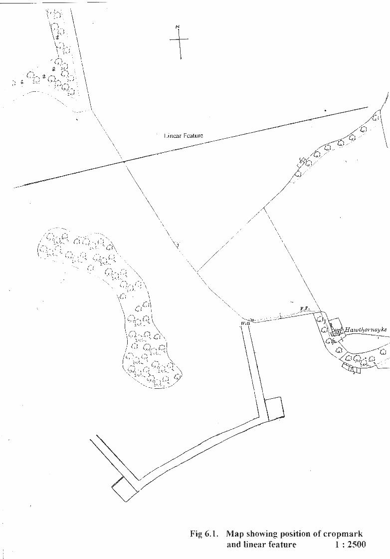
The initial objective of the project was to survey and record a well at the western end of the Hopetoun Estate but this was expanded to add a ground resi~tance survey when a cropmark was found on an RCAHMS aerial photograph. The eastern limb of the cropmark was adjacent to the well. This part of the cropmark was under grass but was crossed obliquely by a new farm track; the ground resistance measurements were made to the north and south of this track across the line of the cropmark. The southern side of the cropmark was in a ploughed area which was fieldwalked and produced little in the way of finds. On the north side of the flat topped hill, that was enclosed on three sides by the cropmark, the remains of a bank and ditch were found; the croprnark is not apparent on this side of the hill and the relationship between bank, ditch and cropmark is unknown. About 250m. to the north of the cropmark a linear feature was observed that crossed a field under cultivation; two very limited areas of ground resistance measurement were taken across this alignment where it emerged onto a field under grass.
Citation preview


\
EDINBURGH ARCHAEOLOGICAL FIELD SOCLETY
Geophysical investigation on the Hopetoun Estate West Lot hian
Contents
1. Summary
2. Introduction
3. Method
4. Results
5. Conclusions
6. Figures 6.1 Map showing position of cropmark and linear feature 1 : 2500 6.2 Aerial photograph 58/RAF/1713 F21 0036 13.04.1955 6.3 Ground Resistance Plot. Cropmark eastern arm. 6.4 Location of resistance surveyed areas. 1 : 2500 6.5 Photograph of well and linear feature from south. 6.6 Ground Resistance Plot. Linear Alignment
7. References
8. Acknowledgements

EDINBURGH ARCRAEOLOGICAL FLELD SOCIETY
Geophysical Investigation on the Hopetoun Estate West Lothian
1. Summary
The initial objective of the project was to survey and record a well at the western end of the Hopetoun Estate but this was expanded to add a ground resi~tance survey when a cropmark was found on an RCAHMS aerial photograph. The eastern limb of the cropmark was adjacent to the well. This part of the cropmark was under grass but was crossed obliquely by a new farm track; the ground resistance measurements were made to the north and south of this track across the line of the cropmark. The southern side of the cropmark was in a ploughed area which was fieldwalked and produced little in the way of finds. On the north side of the flat topped hill, that was enclosed on three sides by the cropmark, the remains of a bank and ditch were found; the croprnark is not apparent on this side of the hill and the relationship between bank, ditch and cropmark is unknown.
About 250m. to the north of the cropmark a linear feature was observed that crossed a field under cultivation; two very limited areas of ground resistance measurement were taken across this alignment where it emerged onto a field under grass.

2. Introduction
The initial approach that had been made to the Factor of the Hopetoun Estate was to obtain permission to examine and record the well site at NGR NT 061 786. The well is shown on the map (Fig.6.1) and it is recorded by Brooke (Ref7.1) as lying in "Nyniwells Field". A relationship is suggested between the name of the field and the early church at Abercorn, 2km. to the east, due to the involvement of St. Ninian. In preparation for this project aerial photographs in the RCAHMS collection were examined and a large cropmark was found that does not appear on the NMRS database. The cropmark lies immediately to the west of the well and its size and shape are indicated in Fig. 6.1. Due to the finding of the croprnark permission was also requested to perform some fieldwalking and ground resistance measurements +cross its eastern limb. Whle these measurements were being made it was realized that a h e a r feature, also indicated on Fig. 6.1, crossed the field to the north and two small sets of ground resistance readings were taken across the line of the feature where it crossed westwards into a field under grass. Geologically the area is primarily part of the Upper Oil Shale Group comprising mudstones, sandstones, limestones, coal seams and some ten oil shale seams. Within this group there is a large area of agglomerate in vent stretching from west of the Binns to within 250m. of Hawthornsyke and within this agglomerate two centres of olivine-basalt. One of these centres forms Binns Hill and the other, to the east, is surrounded by the large rectangular cropmark. The flat top of thls eastern hill appears to have been artificially levelled but this may be due purely to the lava flow. A fault runs E-W along the north side of this agglomerate in vent area and may be the reason for this side being steeper than the south and west sides. Basaltic Tuff is shown extending both east and west from the agglomerate on the BGS map (Ref. 7.2). The geophysical surveys were conducted using a Geoscan Research RM 4 equipment and PA 1 frame taking readings every metre; the readings were manually recorded and then typed into a computer running the Geoscan Research Geoplot programme. The hmited amount of time that was made available for the surveys together with the poor weather conditions meant that only four transects were made across the eastern arm of the cropmark with two small sets being made across the linear feature that lay to the north. A small triangular area had been ploughed at the southern end of the cropmarks eastern arm and the whole of the south side of the cropmark lay in a ploughed field; both of these areas were fieldwalked The elevation of the hill is such that a good view is obtained both up and down stream from Blackness Castle which the hill overlooks. The north side of the hill, on which no cropmark appears, drops away sharply to an area that appears boggy and is uncultivated. The remains of a wall and ditch run along this north side of the hlll. Visits were made to the site and ground resistance readings were taken on 22 November 2001 and on 16 and 29 January 2002.
2

3. Method
The eastern limb of the cropmark, see Figs. 6.1 and 2, lay just to the west of the well. Tt ran south from the well to a rectangular depression that showed clearly on the aerial photograph. The photograph was taken approximately vertically and it was felt that no transcription was necessary to find the area of cropmark on the ground. A baseline was set up from the well to the northwest corner of the depression and the corner point was defined by being measured in to two electricity supply poles to ensure that the baseline could be re-established at a later date. The baseline was not exactly co-linear with the eastern arm of the cropmark but by making transects at right angles to this line crossing of the cropmark could be ensured. Two block transects were made on 22 November 2001; the first was 20m. south of the well and it measured 20m. N-S and 31m. E-W. The second was sited 80m. south of the well on the south side of the obliquely crossing farm track and measured 7m. N-S and 3 1 m. E-W. (Blocks 1 and 2) The printouts of these readings confirmed that a feature had been recorded, the northern block looked particularly interesting and the measirements made on 16 January 2002 were located to the north and south of this block. That on the north side was 1 lm. N-S by 36m. E-W and that to the south was 6m. N-S by 36m. E-W, (Blocks 3 and 4). These areas extended 5m. further to the west in order to include a high resistance area that appeared on the edge of the earlier transect. The combined print of these three surveys gives a block starting 9m. south of the well and extending a total of 37m. southwards. The printout of the four surveys is shown in Fig.6.3 and the spacing of the four transects in relation to the baseline in Fig. 6.4, together with the position of the linear alignment transects. As the 21 January 2002 was to be the final visit to the site it was decided to record the linear feature that crossed the field to the north of the cropmark. A compass bearing was taken across the field on the line of the feature (82" M) and a reciprocal bearing from the same point gave the line across the field to the north of the flat topped hill. The line was identified by a change in the colour of the coarse grass in the field. Two small transects were made across the feature; the first was spaced 5m. from, and ran parallel to, the wall; it measured 26m. along the line of the wall by 8m. at rightangles. Transect 2 was 105m. from the field wall and measured I lm, across by 1 Om, along the observed line of the feature. The line of readings taken on the north side of transect 2 were the same distance north of the centre line of the feature as the eleventh reading taken in the f i s t transect adjacent to the wall. A small triangular ploughed field that lay immediately to the north of the rectangular depression straddled the cropmark and was fieldwalked. The line of the cropmark to the west of the rectangular depression was within a ploughed field and terminates in another rectangular shape rather less clear than that at the southeast corner. The cropmark then turns through just over a rightangle to head northwards towards the flat topped hill. This whole ploughed area was the subject of a walkover survey up to the point where the cropmark leaves this field and appears to cross the western shoulder of the hill. Viewed from the south the crossing point shows a distinct change of slope.
3

4. Results
4.1. The Well The well is enclosed within a small fenced area which excludes cattle but results in it being difficult to access and weed covered. The water in the well is some 0.1 m, deep, fresh and appearh to be running. A comment made by MacDonald (Ref7.3) would suggest that it forms part of an old water course. The well is surrounded on three sides by a wall of large well cut sandstone blocks. The overall width of the construction is 1.28m., the width of the walls on either side is 0.35m. and the aperture is O.58m. The height of the walls fiom the water level is approximately 0.65m. The well is partially roofed by two large sandstone slabs; the one nearer the front appears to have been moved a little from its original position. These roofing slabs would preclude drawing water from the wel! in a conventional manner. Access to the well is down a short, fairly steep slope to the side that is not walled. A photograph of the well is shown in Fig. 6.5; the distance between the two red markers on the walking stick is 0.5m.
4.2. Cropmark Ground Resistance The combined printout of three of the four surveys made on the eastern limb of the cropmark shows a linear high resistance about 3.0m. wide (E-W) to the east of which is a linear low resistance about 9.0m. wide. To the east of this linear low the ground resistance rises again for about 7.0m. but not to the same high level as the narrower high resistance on the west of the survey. The fourth transect, that was 80m. from the well and 7 . h . wide, was taken across the southeastern end of the eastern limb of the cropmark; its south side was 21.4m. fiom the rectangular depression. The linear "highs" and "lows" seen on this more southerly transect (Block 2) d8er from those to the north and may show a termination of the ditch with the
'. small angle of high resistance in the southwest corner representing an entrance to the area enclosed by the cropmark.
4.3. Linear Alignment Ground Resistance The two surveys made across the linear alignment were limited by appalling weather and early afternoon darkness. This alignment appeared as a ridge across a field under cultivation to the north of the cropmark but was less obvious where it crossed westwards under a field wall to proceed across a rough uncultivated field on the north side of the flat topped hill. The survey that was made 5.0m. fiom, and parallel with, the field wall shows a low resistance about 4.0m. wide on the line of the feature with high resistance areas on either side. The reason for the resistance ohange along the centre of the survey parallel to the wall is unknown. The smaller survey made 105m. to the west shows a similar but narrower low resistance with hgh resistance patches only on its northern side. The printout of both transects is shown in Fig. 6.6

5. Conclusions
5.1 The Well The map Fig. 6.1 , shows a footpath from Hawthornsyke to the well probably indicating that it was their only source of water. Hawthornsyke stands on rising ground and no well is sho& adjacent to the house. According to MacDonald (Ref.7.3), the name first appears in 1340 in the Registrum honoris de Morton and the well could thus have been in use fiom that date or earlier. The drystone construction of the well surround gives no indication of its date of building and may post-date its early use. The connection of the well to St. Ninian would appear to be the reason for the field named on the 18th. century Hopetoun estate map. The Anglian bishop to the Picts, Trumwine, who left Abercorn in A.D.685 after the battle at Nechtansmere is documented by MacQueen (Ref.7.4) and an earlier church at Abercorn, possibly founded by St. Ninian, provides a reason for the Anglian church basing its bishop there. No earlier church has been confirmed by archaeological dig and as the field and well site is about 2km. to the west of Abercorn this distance may be seen as a reason to doubt any very close connection 5.2 Cropmark Ground Resistance The linearity of the high and low resistances m a t ~ h well the alignment of the cropmark and suggest a wall or bank on the inner (western) side with a ditch to its east, represented by the low resistance. A further bank, possibly the upcast from the ditch, lies to the east of these two. The depth of the topsoil over these features is not known but it cannot exceed 0.75m. or they would not be detected. The ground rises quite steeply to the west and the topsoil could well become thinner over what is known to be igneous bedrock. The possible effect of the local geology on the resistance measurements must be accepted but the clarity of the cropmark and its alignment with the high and low resistance lines does point to an archaeological feature. It is also significant that the ground resistance is seen to fall to the west (uphill) side of the 3.0m. "high"; if the topsoil was shallower here the expectation would be for the resistance to stay high over the bedrock. The cropmark and its ground resistance interpretation show all the signs of being a defensive surround to the hill which is in a strategically commanding position overlooking the Forth Estuary. The Romans might have been expected to use a site at such a commanding height at the eastern end of the Antonine Wall but the shape of the cropmark does not immediately suggest Roman origin. Smyth (Ref7.5) says "it was not until c.640 in the reign of Oswald that the Northumbrians pushed forward to the Forth; I have suggested that their frontier with northern Britain rested near the present boundary of Mid and West Lothian. Abercorn would have been set up as a frontier outpost." Ths could suggest a possible fort to defend Trumwine and his Bishopric. It is recorded by McNeill and MacQueen, (Ref 7.6), that Edward I spent from 1 1 to 17 August 1298 at Abercorn after the battle of Falkirk on 22 July. Laing (Ref7.7) states that "Edward I built timber palisade forts (peels) that were a feature of his Scottish campaigns -defended with wide ditches and banks". Simpson and Galbraith (Ref.7.8) record an account of Galfrid de Merre, the King's tentmaker, for "wages for valets guarding the King's tents at Dunfermline, St. Andrews, Blackness, Stirling and Newcastle from 20 November 1303 to 19 November 1304. A palisade fort is thus equally possible.

5.3 Linear Alignment Ground Resistance The two surveys are similar and would appear to be transects across the same feature. The alignment of the feature suggests it could form part of the Queensferry to Bo'ness and inl lit hi ow road system that crossed the Midhope Burn on the north side of Abercorn and is shown on the James Knox Edinburghshire map of 1821122. If it has been this road that
- was detected the low resistance could indicate that the surface was clay bonded and is still water retentive. The irregular high resistance patches suggest pits from which road material could have been dug but only by investigating these would it be possible to explain why the infilling was of higher resistance. The extension of this alignment to the west entered an area of ground that had been ploughed adjacent to the Binns Estate border. No indication of a road surface was found at the 0.4m. cut at the edge of the ploughed area nor any obvious stones along the projected line although these may have been removed during previous cultivation. It is possible that the alignment could have changed or that the surface could have been deeper than the plough depth.
5.4 Fieldwalkinn Finds The two areas that were walked produced few finds none of which were of particular relevance diagnostically. The walk along the southern side of the cropmark to the S. W, corner and then north to the fence which divided the ploughed field from the grassed hill produced two pieces of struck grey flint, both showing a section of cortex, and one small piece of possibly struck chert. None of the three appeared to be any sort of tool. The small triangular field that lay across the eastern arm of the cropmark, immediately to the north of the rectangular depression, yielded one rough sandstone disc approximately I .Ocm. in thickness and 6.0cm. in diameter, weight 85grm.; it could have been used as a pot lid. Four pieces of green-glaze pottery were also found in this field. Three are badly abraded, two have a very small amount of glaze remaining and one has none. Two body sherds are outwardly pink where the glaze is worn and inwardly grey, presumably due to underfiring; the thicker one is lighter grey with more and slightly larger inclusions visible at the broken edges. It is possible that this sherd, that has no glaze, did not form part of a glazed vessel as the fabric is similar to white gritty ware. The third sherd is a small section of outwardly curved base, pink with few small inclusions and a little remaining internal glaze. The final sherd is a grey bodied rim sherd, with no abrasion and green glazed on both its inner and outer surfaces although the outer has been largely broken away. The total weight of the four sherds is 45grm.
It is hoped that further work may be permitted to explore, in more detail, both cropmarks and, if excavation permission was given, to attempt to obtain dating evidence.

6. Figures
6.1 Map showing position of cropmark and linear feature. 1 : 2500
6.2 Aerial Photograph Sortie 58/RAF/17 13 Frame F21 0036 ~ k e d 13.4.1955 Scale 1 : 10,000 (Crown copyright)
6.3 Ground Resistance Plot. Cropmark eastern arm.
6.4 Location of resistance surveyed areas.
6.5 Photograph of well and of linear feature. Both viewed fiom the south
6.6 Ground Resistance Plot. Linear Alignment.
7. References
7.1 Brooke D. Wild Men and Holy Places
7.2 British Geological Survey Scotland Sheet 32W 1; 50,000 Solid Edn.
7.3 MacDonald A. The Place names of West Lothan
7.4 MacQueen J. St. Nynia
7.5 Smyth A. P. Warlords and Holy men. A.D. 80-1 000
7.6 McNeill P.G.B. and MacQueen H.L. Atlas of Scottish History to 1707
7.7 Laing L. Ancient Scotland
7.8. Simpson G. and Galbraith J.D.(Eds.) Calendar of documents relating to Scotland.
The Society wishes to record thanks to the following for their help and cooperation, in various ways, towards the completion of this project. 8.1 The Factor of the Hopetoun Estate, at the time of this investigation Mr R.McD.
Seligman, for his permission to survey on the Estate and to Prof W MacLennan for making the day to day arrangements.
8.2 Mrs V E Dean for comments on the green glaze pottery 8.3 RCAHMS for permission to use the aerial photograph Fig. 6.2.