Embed Size (px)
Citation preview

The boundary between western valley-like and eastern plateau-like Pohorje with the [iklarica pass, 1299 m.
Meja med slemenasto-dolinastim zahodnim in planotastim vzhodnim Pohorjem. Vmes je preval [iklarica, 1299 m.
IVA
N G
AM
S
Acta geographica Slovenica, 48-2, 2008, 187–254
GEOMORPHOLOGY OF THE POHORJE MOUNTAINS
GEOMORFOLOGIJA POHORJAIvan Gams

Ivan Gams, Geomorphology of the Pohorje mountains
Geomorphology of the Pohorje mountains
DOI: 10.3986.AGS48201UDC: 911.2:551.4(497.4Pohorje)COBISS: 1.01
ABSTRACT: The Pohorje mountain range, young mountains with prevailing metamorphic rocks and dacite,continues to uplift above the igneous laccolith in the area of the rapid rising asthenosphere in the tran-sition to the Pannonian basin also due to changes in temperature and, resultantly, of the density of upliftingdacite- and other intrusions which have not metamorphosed the surrounding sediments. On the Pohorjeby the river Drava (hereinafter the Drava Pohorje), the drainage network does not match the orography,because, between the Vuzenica-Radlje basin and Fala, the Drava epigenetically deepened its gorge intothe marginal range of Kobansko. Modest plateaus on the ridge of the Pohorje originate from the time whenthe base level maintained a cover of the so-called Eibiswald strata between the Karavanke and the Kobanskoin the upper Miocene. The originally larger ridge plateau in the centre of the Pohorje was lowered by ero-sion and periglacial processes; it has been preserved as an inclined plateau on the Eastern Pohorje. Explainedthrough the recent tectonic shifting, established by means of GPS in the years 1996–2002 at the peak VelikaKopa, is the southeastwards curving of the five valleys above the Legen terrace where, supposedly, originalheadwaters of the Spodnja Mislinja came from. Due to its geological, geomorphological and hydrologi-cal peculiarities the Legen Quaternary terrace deserves that it should be declaired the šgeopark’, the firstone in Slovenia. Even more explicit and extensive is the westwards curving of the valleys on the north-ern slope of the Pohorje, and their northeastward orientation in the Ribnica-Lovrenc-Selnica valley system.In the east section of the Lovrenc valley system above Fala the brook Re~nikov potok has not adjusted itscourse to the recent tectonic subsiding, so that its valleys run obliquely to the slope inclination. The upto 700 metres deep Mislinja rift lowered the central ridge of the Pohorje to 1299 metres. Blowing intense-ly across it, the northeastern Pleistocene cold winds made possible the origination of two smaller glaciersin the upper drainage basin of the Radoljna. The gently sloping Pohorje landforms are not the result ofthe old age but of the disintegration of granular rocks to permeable sand, above which the thick cover ofcontinuous roots of grasses and prevailing spruce reduces the erosion.
KEY WORDS: Geomorphology, geomorphogenesis, Quaternary geomorphological processes, glaciers,Pohorje, Central Alps, northeastern Slovenia.
The article was submitted for publication on March 12, 2007.
ADDRESS:Ivan Gams, Ph. D.ulica Pohorskega bataljona, SI – 1000 LjubljanaE-mail: [email protected]
188

Contents
1 Introduction 1902 Delineation and division of the Pohorje 1903 The impact of rock structure 1944 Relief units 1954.1 The Drava valley 1954.2 The Drava Pohorje 1974.3 The Ribnica-Lovrenc-Selnica valley system 1984.4 The northern slope of the Pohorje 2004.5 The eastern and southeastern Pohorje 2014.6 The Mislinja Pohorje 2044.6.1 The Mislinja valley 2064.6.2 The Slovenj Gradec basin 2064.7 The northwestern Pohorje 2124.8 The Pohorje plateau 2125 The intensity of geomorphological processes 2135.1 The Pleistocene glaciation on the Pohorje 2185.2 Peat bogs and lakes on the Pohorje 2226 On the special feature of the geomorphological
researches into the mountains of the Pohorje type 2246.1 Ridges and valleys as indicators of geomorphological
development 2246.2 Delamination impact 2277 Conclusion 2278 References 229
Acta geographica Slovenica, 48-2, 2008
189

Ivan Gams, Geomorphology of the Pohorje mountains
1 IntroductionThe Pohorje is a medium-high mountain range in northeastern Slovenia. In view of geology it is the south-easternmost part of the Eastern Alps. It mainly consists of metamorphic rocks and dacite.
Until the Second World War, also Slovenian geomorphologists advocated the theory of cyclic reliefdevelopment according to which, after the tectonic uplift, the mountainous surface continuously and grad-ually lowered due to erosion with the intermittent stagnation phases which are identifiable in the everlower levels and terraces. In view of this theory geomorphology used to interpret the origin of the ridgePontian (Pannonian) levels also on the ridge of the Pohorje. Lower and younger planations were estab-lished on the side ridges. But there are no such planations on the evenly lowering Pohorje ridges and theuplifting of the Pohorje continues. This was corroborated by the recent repeated nivelman points and GPSmeasurements (of relative surface shifts by means of satellite radars).
Most of the used Slovenian topographic names are taken from the Atlas Slovenije (the Atlas of Slovenia)in the scale 1 : 50,000 and partly also from topographic section maps in larger scale.
2 Delineation and division of the PohorjeWithin the Eastern-Alpine (earlier name: Central Alpine) mountains the Pohorje with its 770 sq km belongsto the larger ones. Its delineation in the present paper equals its delineations in the hitherto monographson the Pohorje (Hiltl 1893; Koprivnik 1923; Melik 1957; Gams 1959). It borders on the following areas:the Drava valley in the north, the Dravsko polje plain in the east, the Pohorje foothills in the southeast,the Vitanje valley system in the south, and the Mislinja valley in the northwest.
The names of geomorphological units given on the map are also used in the present text. We adhereto the traditional division, i. e. to the Eastern Pohorje with less inclined slopes, and the Western Pohorjewhich is typical for a greater number of ridges and valleys. The contact line between the two sections runsalong the Mislinja rift–[iklarica–the Radoljna valley. A detailed geomorphological division has been madeof each of the two sections. The geomorphologically and genetically diverse Pohorje is further analysedby relief characteristics of individual more homogeneous units:• 1 Western Pohorje• 1.1 The northwestern Pohorje is the area lying northeast of the lower Mislinja valley and west of the (Trbonje)
Reka valley, with the highest peak Jesenkov vrh (933 metres). It belongs petrographically to the Kobanskoseries (Mio~, @nidar~i~ 1972). Almost all the rocks occur here which constitute the rest of the Pohorje andthe Kobansko in particular, and also the upper-Miocene (Eibiswald) strata occur above the average.
• 1.2 The central Pohorje is the system of the northwest oriented central and the highest watershed ridgebetween Krem`arjev vrh (1164m) and [iklarica (1299m), and the ridges between the valleys of the Mislinjatributaries in the south, and the Drava tributaries in the north. It mainly consists of metamorphic rocks anddacite. This section of the Pohorje is typical for the high broad watershed ridge Mala Kopa (1524 m)–Ve-lika Kopa (1543 m)–Jezerski (Ribni{ki) vrh (1537 m). The wooded northern slope mainly consists ofgranodiorite (formerly called granite and later on tonalite) and andesite, and the ridges of the promon-tory to the Vuzenica-Radlje basin consist of the upper-Miocene conglomerate, marl and sandstone. Onthe southern, i. e. the Mislinja slope gneisses and micas prevail.
• 2 The eastern and southeastern Pohorje is the area lying east of the deep valleys of the Lobnica and theMislinja rift. It is the most massive section of the range and represents a half of the Pohorje. This sec-tion is less rugged than the rest of the range.
• 2.1 The Maribor Pohorje is the area with the highest ridge Planika–Klopni vrh (1340 m)–@igartovvrh–Ledinekov vrh (1182 m)–Bolfenk. Towards the bottom of the Drava valley its steep northern slopetransforms into the Neogene vinegrowing Limbu{ hills, which geologically do not belong to the Pohorje.
• 2.2 The corner peaks of the Pohorje plateau are Veliki vrh (1303 m), Travni vrh (1273 m), Klopni vrh(1340 m) and the eastern slope of the ridge Pesek (1423 m)–Plesi~ (1407 m).
190
Figure 1: Altitudes above sea level. p str. 191Figure 2: Surface inclinations of the Pohorje. p str. 192Figure 3: Division of the Pohorje surface with the drawn-in selected geomorphological elements: geomorphological unit, ridges, extent ofdrainage basins, extent of Plio-Quaternary marginal basins, typical slope bends (continuous line), strike-slip fault at the valley bottom (dashedline), moraine, ring structure. p str. 193

Acta geo
graph
ica Sloven
ica, 48
-2, 2
00
8
19
1
@avcarjev vrh915
Veliki vrh1344
Rogla1517
^rni vrh1543
Ple{i~1407
Klopni vrh1340 @igartov vrh
1346
Volovica1455
Velika Kopa1542
Krem`arjev vrh1164
Kavnikov vrh926
Basali{~e1272
Stenica1091
Oplotnica
[martno priSlovenj Gradcu
Staritrg
Pame~e
Mislinja
Selnicaob Dravi
Bistricaob Dravi
Razvanje
Pekre
BresternicaKamnica
Limbu{
Radizel
Vuzenica
PragerskoTopol{ica
Ravne
Zre~e
Ru{eLovrencna Pohorju
Muta
Spodnje Ho~e
Dravograd
Radljeob Dravi
[o{tanj
SlovenskeKonjice
SlovenjGradec
SlovenskaBistrica
Maribor
Velenje
Paka
Mislinja
BistricaOplotnica
Mislinja
Radoljna
Lobn
ica
Paka
Bistrica
Drava
Drava
K OB
AN
SK
O
SEVER
OZAH
OD
NO
PO
HO
RJE
OBDRAVSKO POHORJE
RIBNI[KO-LOVREN[KO-SELNI[KO PODOLJE
MARIBORSKO POHORJE
POHORSKAPLANOTA
VZHODNOPOHORSKANAGNJENA PLANOTA
ZRE[KOPOHORJE
VITANJSKOPOHORJE
PA[KOPOHORJE
S
RE
DN
JE
P O H O R J E
KO
Z J A K
SP
OD
NJA
MIS
LINJS
KA
DO
LINA
SLO
VENJG
RA[KA
KOTLIN
A
P A [ K I K O Z J A K
S T E N I C A
KONJI[KA KOTLINA
1200–1599 m
200–399 m
400–599 m
600–799 m
800–999 m
1000–1199 m
Scale/merilo:
Author of contents/avtor vsebine: Ivan Gams
Author of map/avtor zemljevida: Mauro Hrvatin
© Geografski in{titut Antona Melika ZRC SAZU
DEM/DMV: InSAR DMV 25, ZRC SAZU
0 42 8 km6

Ivan G
ams, G
eom
orp
ho
logy o
f the P
oh
orje m
ou
ntain
s
19
2
@avcarjev vrh915
Veliki vrh1344
Rogla1517
^rni vrh1543
Ple{i~1407
Klopni vrh1340 @igartov vrh
1346
Volovica1455
Velika Kopa1542
Krem`arjev vrh1164
Kavnikov vrh926
Basali{~e1272
Stenica1091
Oplotnica
[martno priSlovenj Gradcu
Staritrg
Pame~e
Mislinja
Selnicaob Dravi
Bistricaob Dravi
Razvanje
Pekre
BresternicaKamnica
Limbu{
Radizel
Vuzenica
PragerskoTopol{ica
Ravne
Zre~e
Ru{eLovrencna Pohorju
Muta
Spodnje Ho~e
Dravograd
Radljeob Dravi
[o{tanj
SlovenskeKonjice
SlovenjGradec
SlovenskaBistrica
Maribor
Velenje
Paka
Mislinja
Bistrica
Oplotnica
Mislinja
Radoljna
Lobn
ica
Paka
Bistrica
Drava
Drava
P
O
H
O
R
JE
K OB
AN
SK
O
KO
Z J A K
30 and more/in ve~°
0–1.9°
2–5.9°
6–11.9°
12–19.9°
20–29.9°
Scale/merilo:
Author of contents/avtor vsebine: Ivan Gams
Author of map/avtor zemljevida: Mauro Hrvatin
© Geografski in{titut Antona Melika ZRC SAZU
DEM/DMV: InSAR DMV 25, ZRC SAZU
0 4 8 km6

Acta geo
graph
ica Sloven
ica, 48
-2, 2
00
8
19
3
@avcarjev vrh915
Veliki vrh1344
Rogla1517
^rni vrh1543
Ple{i~1407
Klopni vrh1340
@igartov vrh1346
Volovica1455
Velika Kopa1542
Krem`arjev vrh1164
Kavnikov vrh926
Basali{~e1272
Stenica1091
Oplotnica
[martno priSlovenj Gradcu
Staritrg
Pame~e
Mislinja
Selnicaob Dravi
Bistricaob Dravi
Razvanje
Pekre
BresternicaKamnica
Limbu{
Radizel
Vuzenica
PragerskoTopol{ica
Ravne
Zre~e
Ru{eLovrencna Pohorju
Muta
SpodnjeHo~e
Dravograd
Radljeob Dravi
[o{tanj
SlovenskeKonjice
SlovenjGradec
SlovenskaBistrica
Maribor
Velenje
Paka
Mislinja
BistricaOplotnica
Mislinja
Radoljna
Lobn
ica
Paka
Bistrica
Drava
Drava
K OB
AN
SK
O
KO
Z J A K
5 10
1
2
3
4
Scale/merilo:
Author of contents/avtor vsebine: Ivan Gams
Author of map/avtor zemljevida: Mauro Hrvatin
© Geografski in{titut Antona Melika ZRC SAZU
DEM/DMV: InSAR DMV 25, ZRC SAZU
9
8
7
6
0 42 8 km6

Ivan Gams, Geomorphology of the Pohorje mountains
• 2.3 The eastern and southeastern Pohorje is less rugged than the rest of the range. Discerned by dif-ferent relief features within this area are the units of the eastern Pohorje inclined plateau, i. e. the Zre~ePohorje, the Vitanje Pohorje and the Paka Pohorje, but the differences are minor only.
• 3 The Pohorje in the wider sense of the word also includes two units which are closely related to theorigin of the Pohorje. These are the Ribnica-Lovrenc-Selnica valley system and the Drava Pohorje.
• 3.1 The Ribnica-Lovrenc-Selnica valley system extends over about 2–3 km wide, mainly undulated land-forms ranging between 300 and 700 m a. s. l. between the settlements Ribnica and Limbu{. It consistsof the upper-Miocene conglomerates, sandstones and marls, and also of the Drava alluvia in its directcontinuation in the Drava valley.
• 3.2 The Drava Pohorje lies between the Drava valley and the Ribnica-Lovrenc-Selnica valley system,and has not been given an official name so far. The above-mentioned name is used for the first time inthis paper. It is a series of ridges high up to 913 m a. s. l., which extend in the east–west direction betweenthe Vuhre{~ica valley and Fala or, to put it otherwise, between the Ribnica-Lovrenc-Selnica valley sys-tem and the Drava valley.
• 4 The Drava valley between Dravograd and Maribor is not entirely part of the Pohorje. Since the Dravadrains waters from the major area of the Pohorje, it is also a subject of this paper dealt with togetherwith the Vuzenica-Radlje basin.
3 The impact of rock structureRecent geophysical and geological investigations into global composition of the Earth under the oceansand under the continents have contributed a lot to the explanation of the origin of metamorphic rocks alsoin the Eastern Alps that reach from the southeast of Austria to Slovenia in the Drava drainage basin on thePohorje. In view of the tectonics the Pohorje consists of thrusts that were generated in the subduction zoneof the Palaeotethys between the Ordovician and the Devonian. In the Varistic and the Alpidic orogenesisthey were metamorphosed with varied intensity (Premru 2005, 206; Hinterlechner-Ravnik, Moine 1977).Let us examine, for example, eclogite that occurs on the Pohorje. It is generated at the pressures of about3 Gpa and temperatures 760–820 °C. Such conditions prevailed in the Silurian-Caledonian period500–435 million years ago during the subduction of the Palaeotethys ocean plate under the edge of the con-tinental plate. The Pohorje rocks underwent another metamorphosis during the younger tectonic phases.
In the sense of the delamination theory, intrusions of magma into the asthenosphere caused extra uplift-ing of veined rocks to the surface of the Earth, due to the low-pressure and low-temperature metamorphoses.Geology has established several intrusions of magma into the asthenosphere, which caused such diver-sity of rocks. According to Premru (2005), there are traces on the Pohorje, in the wider sense of the word,of eight joint systems running in diverse directions which originate from the time between the upper mid-dle Pliocene and the Holocene. It is not reasonable to discuss on this point the different geologicalinterpretations of the origin of palaeorelief, because the issue here is of geomorphological analysis of thepresent relief and of the differences in it in particular.
According to geologists, the Pohorje metamorphic and igneous rocks are the eastern continuation ofthe so-called Periadriatic Lineament shifted northwards (Mihevc, Vrabec 2005). Mio~ and @nidar~i~ (1972)divide the Pohorje and the Kobansko metamorphic rocks into 28 units. Nevertheless, some of them arenot homogeneous as to their chemical composition and compactness; granodiorite, for example. The analy-sis of three samples (Faninger 1973, p 35) established percentages of silica between 25.2 and 30.6%. Rarelimestones occur as elevations at some places, but, in general, the relief does not reflect the differences inthe composition of metamorphic rocks. It also applies to the upper-Miocene strata, i. e. conglomerates,sandstones and marls. They form the undulated Ribnica-Lovrenc-Selnica valley system which is, accord-ing to Melik (1957), supposedly made of less resistant sediments. A wider area than this one is occupiedby the equally old sediments in the up to 845 m high mountains between the western surroundings ofRibnica and the Vuzenica-Radlje basin, but the medium-high ridge-and-valley relief of that place doesnot differ significantly from the adjacent territory of metamorphic rocks in the Drava Pohorje. The con-tact zone of granodiorite with other metamorphic rocks, which runs along the Pohorje watershed ridgebetween the Mislinja and the Drava drainage basins, or between the peak Velika Kopa and the pass [iklar-ica, is mainly not reflected in the relief forms. However, along this contact runs the highest watershed ridge
194

between the peaks Mala Kopa and Rogla, conditioned by lesser resistance to tectonic uplifting. But eastof Sedovec (1232 m), which belongs to the Maribor Pohorje, the higest watershed ridge consists of mus-covite-biotite gneisses with transitions to mica, while the lower lying granodiorite area moves off ever moreto the south. It was not the petrographic composition but the tectonics that determined the relief here.The eastern Pohorje valleys became deeper at some places after crossing the granodiorite-gneiss contact.Located at such a contact is the upper fall of the brook Bistrica ([u{ter{i~ et al. 2005, 17).
The great petrographic diversity of metamorphic rocks does not have a stronger influence on the smallsurface forms, because the metamorphic rocks, except for rare cases, as well as the magmatites are moreor less grained and, when once on the surface, disintegrate into sand rather quickly (an old local term forthem in the western Pohorje is »grained stone«). Sand occurs in a thicker subsoil layer in the central Pohorjeon less rugged areas, called »planje« (planes) by the locals. The usual inclinations there range between11° and 19°, and 20–33° on the slopes of deeper valleys.
The inclinations in the above-the-average steep Mislinja drainage basin on the Pohorje above Dov`e,amount to 22° 40' (Gams 1976, 188). The influence of rocks on the relief is slightly more evident in theeastern Pohorje slope between the settlements Bo`je and Spodnje Prebukovje, where the river valleys areshallower and wider in the zone of transition of granodiorite to gneiss. Between ^rni vrh and Jesenkovvrh the Pohorje seems as if shot through with circles and belts of dacite, and the surface inclination ofKrem`arjev vrh (1164 m) is slightly above the average, of its northern slope in particular. At the transi-tions of dacite to dark phyllitoid schist on the saddle Pungart near Grmov{kov dom, there is about onehundred metres wide grass shelf on phyllitoid schist, which is an exception on the Pohorje.
Steep above the average are the isolated mountains of Cretaceous limestone amidst metamorphic rocks(Jesenkov vrh, 933 m; Golek, 769 m; Brinjeva gora, 520 m in the vicinity of Zre~e). Some crashed carbonaterocks got embedded in between metamorphic rocks in such positions that they are not exposed in therelief. Bigger islands of carbonate rocks, especially the one with the church of the Holy Spirit at Ostri vrh(903 m) on the Kobansko, and the other one at Jesenkov vrh (933 m) in the northwestern Pohorje, bothon the top of the ridge, rise steeply above the surroundings. They are supposedly the remains of the thrustfrom the Karavanke (Mio~, @nidar~i~ 1972). This helps to interpret most conveniently the origin of the863 metres high mountain Lo{ka gora, which lies only two-to-three kilometres away from the northernedge of the carbonate Mt. Sténica in the Karavanke.
Until recently, the humans exerted the greatest impact on soil erosion by ploughing parallel to thecontour lines; due to the ploughing translocation of soil it accumulated at the bottom edges of those fieldswhere landslips occurred. The linear erosion is still intense at the lower side of asphalt roads where theyinterrupt the flows of groundwater which has been collected higher up in relief depressions. On the Pohorje,too, the soil erosion is more intense on steeper locations (comp. Komac 2005, Figures 4 and 7).
Prior to the Plio-Quaternary, an extensive cover of upper-Miocene sediments had spread from the Grazbasin across the Pohorje to the Karavanke (Sölva, Stuve, Straus 2005). These sediments on the Pohorje (ina wider sense of the word) also contain pebbles of metamorphic rocks, among others also those of gran-odiorite and dacite. This fact supposedly proves that they had already been dismantled on the ridge of thePohorje (in a narrower sense of the word) as early as the upper-Miocene. However, in the same Eibiswaldstrata similar admixture also occurs in the Kobansko area (Mio~, @nidar~i~ 1972, 40–41). Dismantled justbelow the Kobansko pass Radelj are the Radlje layers with pebbles of metamorphic rocks, up to one metrelong. The Eibiswald strata have survived in the form of circles or stripes in the relief depressions (e. g. theRibnica-Lovrenc-Selnica valley system) and in mountains as well, all in tectonic basins that have protectedthem from erosion. At such locations their total depth amounts to, for example, 420 m in the Kaplja syn-cline, 500 m in the Ribnica-Selnica tectonic rift, and 1110 m in the area of Radlje and Rem{nik (Mio~,@nidar~i~ 1978, 38, 63). Preserved in the tectonic depressions, they indicate their original thickness and extent.
4 Relief units
4.1 The Drava valley
Concurrently with the uplifting of Golica (the Koralpe), the present Drava, as the outflow from theLawamünd basin, was sliding along the Lavanttal/Labot fault towards the southeast to Dravograd. However,
Acta geographica Slovenica, 48-2, 2008
195

Ivan Gams, Geomorphology of the Pohorje mountains
it did not break its gorge through the western Pohorje at its lowest ridge, i. e. the saddle Cvitr{ko sedlo(677 m) which consists of Helvetic sediments, but on the chlorite-amphibolite schist, amphibolite andultrabasic diabase which occur on both sides of the Dravograd breakthrough valley between Me`narjevvrh (800 m) on the Pohorje and the long ridge of Ko{enjak in the settlement Ojstrica. The valley slope issteep on the Pohorje side, but gently sloping under the higher Ko{enjak (1522m) whose uplifting was quick-er and, consequently, the latter pushed the river to the south. In the continuation of the valley to Trbonjeboth the Kobansko and the Pohorje sides are equally steep. The valley along the onetime Styrian-Carinthianborder is the narrowest halfway from Dravograd to the Vuzenica basin, which points to the onetime water-shed between the tributaries to the Lawamünd basin and those to the Vuzenica basin.
In the valley between Trbonje and Spodnja Vi`inga lies the combined Vuzenica-Radlje basin. Duringthe construction of the hydropower plant at Vuzenica 80 metres of the Quaternary Drava alluvia werebored from it (Mio~, @nidar~i~ 1972). Judging from the Quaternary terraces we have established that thecentre of the subsidience lay on the southwest edge of this basin between the settlements Vuzenica andDrav~e. In this direction, i. e. southwards, also the largest Quaternary terrace of the Vuzenica basin intense-ly slopes down, but it has only a slight vertical drop above the southern end of the Kobansko Bistrica valleyfrom Zgornja Gortina to Muta, although the Drava gravel prevails on the top as well. It seems that theDrava was kept back by the Bistrica. At the same altitude on the southern side of the basin a part of theterrace has still been preserved at Zgornji trg in Vuzenica. It belongs to accummulation terraces at thebeginning of the valley of the Cerkvenica. The largest one occurs at Trbonje and also reaches the heightof 380 metres at the northern section of the settlement. Both the above-mentioned terraces are the remainsof the Pleistocene Drava accumulations at the mouths of its tributaries from the Pohorje, including theterrace of the (Me`ica) Dobrova (Kislinger 1929; Gams 1995). Before this terrace the (Trbonje) Reka turnsright and runs for the following 1.5 km in the southeast direction between the elongated dropping Trbonjeterrace and the Pohorje phyllitoid schists with the outcropping islands of dacite. The bedrock of the grav-el terrace is deeper at Vuzenica than by the river at the eastern part of the Radlje basin downstream ofVuhred. On the Kobansko above Vuzenica seismologists installed the station Pernice in 1991; they estab-lished the epicentre in the depth of 15 kilometres and the earthquake endangerment of Richter Scalemagnitude 5 (Vidrih 1992).
In the southern hinterland of the basin near Vuzenica there are numerous dacite outcrops which prob-ably merge in the depth into a bigger laccolith. This may be the cause of the seismic activity of this area.At Vuzenica above Spodnji trg, there is a deposit of dacite tuff (Mio~, @nidar~i~ 1972). According to Premru(2005, 457), the Vuzenica depression is a ring structure which occurs on the surface with the spirally curvedridges and/or valleys above the plutonite. According to the same source, faults in the NW–SE, NE–SW,W–E and N–S directions were established in this basin.
To the east, the Vuzenica basin joins the 6 km long Radlje basin, where east of the Bistrica mouth thelargest, i. e. the Radlje terrace is gross 10 metres lower than the Muta terrace, but is less inclined south-wards than the former and it is all used for fields, in contrast to the Muta terrace. The unestablished depthof the bedrock makes it impossible to guess the intensity of tectonic subsidience, which could be presumedfrom the curved edges both to the north and to the south. With the length of 5 km and the width of upto 5 km it has a similar extent as the Vuzenica basin. According to Premru (2005), either basin is a ringstructure. By subsiding, they both furthered the erosion of the Reka, the Cerkvenica and the Vuhre{~icawhich made long valleys in the upper-Miocene Eibiswald sediments, with intermediate high ridges thatbegin at the Pohorje watershed ridge.
The Drava valley between the Drava Pohorje and the Kobansko is a gorge and consists of mus-covite-biotite gneisses with transitions to mica. The number of Pleistocene gravel terraces decreases eastwards.The remains of a mastodon, found in the 5th terrace level at Brezno, were dated into the Riss by Rakovec(1955). By their relative heights above the bottom of the valley five gravel terraces were possible to be estab-lished along the Drava. The highest terrace has only survived on rare locations in the form of narrowconglomerate remains (Gams 1959). East of Brezno there remains only a rocky gorge with gushing water.
The gradient of the Drava was changed with the construction of reservoirs before the hydropower plantsafter the Second World War. Prior to this, the flow of the Drava was intervened at Fala only. Hiltl (1893)reports that, in order to clear the way for rafts, the obstructing rocks were shot off on this point in 1818,in the total volume of over 15,000 m3. In the 19th century, the Austro-Hungarian Military GeographicalInstitute performed gradient measurements of the river Drava on ten sections. In the 60-kilometre-long
196

river course, between Dravograd and Mariborski otok, the vertical drop of 92 metres was measured, whichmakes the average gradient of 1.53 m/km (Hiltl 1893, 70). On the map of Slovenia in the scale of 1 : 50,000,made before the construction of the hydropower plant, the still winding course of the Drava to Fala was49 kilometres long, which means the gradient of 1.09 m/km. In the Vuzenica-Radlje basin, the gradientto the confluence with the Vuhre{~ica is small, and in the next section to the homestead [turm (on thetop of the turn north of Fala) it amounts to 3.1 m/km and 2.66 m/km from here to Laznica. It seems thatthe Drava gradient as to its water abundance and the coarse stones deposited in the gorge by the directDrava tributaries is rather big and the river would still be able to deepen its riverbed, had there be no humaninterventions.
4.2 The Drava Pohorje
The Drava Pohorje is 19 km long and 3–4 km wide range of metamorphic rocks between the Vuhre{~icavalley and the turn of the Drava above Fala. Up to 913 m high and mainly eastwards oriented ridges withfrequent level top ridges at the altitude between 800 and 900 metres a. s. l. are most intensely rugged bythe valleys of the brooks running from the ridge of the Pohorje.
The Drava Pohorje is the southern wing of the Kobansko anticline. Ridges and valleys on the Kobanskosouthern slope mainly do not continue in a straight line on the other side of the Drava into the DravaPohorje and the left Drava tributaries are much more numerous. Between the settlements Brezno and O`baltthe following tributaries from the Kobansko flow into the Drava: the brooks of Rem{eni{ki potok, Brezni{kipotok, Poto~nikov potok, Javni{ki potok, Grgasov potok and the ^rmenica. Their up to 7 km long val-leys with steep slopes are up to a hundred or even more metres deep in their central and/or lower sections.With their average spacing of one kilometre their density is the highest in Slovenia, which points to theirrecent origin. At Podvelka, the ridge curve rises to Hlebov vrh (913 m) and then starts dropping in the formof a crescent towards the Drava at O`balt.
Acta geographica Slovenica, 48-2, 2008
197
Figure 4: The breakthrough valley of the Drava beyond Dravograd (an eastward view). Right, a slope on the Pohorje; left, the slope underhigher Ko{enjak is less steep; left rear is Kobansko.
IVA
N G
AM
S

Ivan Gams, Geomorphology of the Pohorje mountains
A proof to the fact that the Drava Pohorje has undergone continuous uplifting without major inter-ruptions, just like the Pohorje, is the absence of slope terraces. The epigenesis of the Drava valley wasadvocated also by Melik (1957) and Sölva (2005). Also the thesis, that the old Drava first accumulatedgravel in the Graz basin or in the western Slovenske gorice, is old (Winkler 1944, 145–168). All of the quot-ed authors, Mio~ and @nidar~i~ (1972) as well as Melik (1957, 74–75), believed that in the succeeding phasethe Drava ran along the Ribnica-Lovrenc-Selnica valley system, but they did not give the explaination ofwhen and why the up-to-854 m high range was uplifted in the river basin of the Velka and the Plav`nica,both of which run towards the Vuzenica-Radlje basin. This range is of the same height as the Drava Pohorje.
No more traces remain on the Kobansko of the transversal valley of the Drava towards the Graz basin.On the contrary, the configuration of the ^rmenica, which is the longest river on the Kobansko runningtowards the southwest, points to a recent piracy by the Drava. Its valley is 0.8 km wide at the outflow tothe Drava; 3.5 km upstream, at Spodnja Kapla, it is 2.5 km wide, and in the Eibiswald strata in the water-shed area before the state border, at the settlement Gradi{~e na Kozjaku, it is 6 km wide. There, on theKobansko ridge, the piracy occurred, due to the ^rmenica, of the headwaters of two western tributariesto the Drava, i. e. of the Grgasov potok and the O`baltski potok. The piracy by the ^rmenica corrobo-rates the thesis that downstream of Maribor, in contrast to the Mura, the Drava has greater erosion powerthan the Mura, since its left tributaries are longer than the right ones (Melik 1957).
4.3 The Ribnica-Lovrenc-Selnica valley system
In terms of geology, the Ribnica-Lovrenc-Selnica valley system is made of upper-Miocene conglomer-ates, sandstones and marls. In the basis they consist of clastic material of fluvial origin, those lying higherare of fluvio-limnetic origin, and those on the top are brackish (Mio~ 1977). The surface is mainly undu-lated with the altitudes between 400 and 700 metres. The Selnica valley system, which is the continuationof the Lovrenc valley system, occupies the bottom of the Drava valley from Fala downstream to Maribor.
198
Figure 5: A view from the hill Sv. Anton towards the Pohorje (in the rear) embraces the southern part of 6-km-long mountainous area where,according to some geomorphologists, the Drava supposedly ran in old times and its course continued towards the east.
IVA
N G
AM
S

Below Fala, the Holocene alluvium reaches the rocky bottom at the depth of 100 m. According to [ercelj'spollen analysis (quoted from Mio~, @nidar~i~ 1978) the fluvioglacial alluvial fan at Lovrenc na Pohorjuproceeds from the middle Würm. Between Lovrenc and Fala, in the Lamprehtov potok drainage basin,
Acta geographica Slovenica, 48-2, 2008
199
Dr
Draavvaa
Re~
niko
vpo
tok
Kogel343
Karolina357
Korman
Bla`i~
Jodl
Kajzer
Repas
Petlin
Grajfonar
PU[NJAK
ILGOVA FRATADOBRAVA
Hladej
Orozl
Vrabar
Ranhol
Dobnik
FalaFalaGrad
^in`at
Ruta
[vigl
Repnik
Gomilnik
HaupmanGori~an
Falska pe~452
KLEMENJAKOVAPU[A
LADINA
^E[NJAKOVAHOBA
Scale/merilo:
0 300150 600 m450
300
350
400 300
400
450
450
300
400
350
300
500
450
isolated farmstead/samotna kmetijaAuthor of contents/avtor vsebine: Ivan Gams
Author of map/avtor zemljevida: Mauro Hrvatin
© Geografski in{titut Antona Melika ZRC SAZU
DEM/DMV: InSAR DMV 25, ZRC SAZU
Figure 6: The Re~nikov potok stream is oriented north-eastwards.

Ivan Gams, Geomorphology of the Pohorje mountains
there is a separate little basin with uneven bottom filled with sand clay in which [ercelj established thepollen of the last Würm climax (Mio~ 1977).
In the tertiary hills at the eastern end of the Lovrenc valley system, there is a singular case of the recenttectonics impact on the drainage network. Some 50 metres above the Drava near Fala, there is the ridgeat 420–450 metres a. s. l. oriented northwards, with the settlement ^in`at at its top. At the contact of theNeogene with metamorphic sediments at Rute, there is a 5 km long narrow dacite stripe running in theeast–west direction. Hiltl (1895, 75), the Fala mansion forester, quotes two earthquakes in the Pohorje,those of 1791 and 1794. The relief forms on the eastern slope of the ridge with the settlement ^in`at arenot consistent with the general inclination of the slope in which two valleys begin under the settlement.Into one of them, water from the brook Lamprehtov potok was artificially drawn off at the homesteadRe~nik, horizontally across the slope and along the ridge to the opposite, i. e. the eastern slope of the ridge.The locals still call the entire stream after this homestead, the Re~nikov potok, all to its outflow into thebrook Murkov potok. With this divertion the water power increased for the needs of saw mills that havelong been abandoned by now. Recently, a part of this water from ^in`at was channelled straight downthrough pipes for the needs of a new local hydropower plant on the Drava when it is in operation. If theRe~nikov potok would also run to this point, its course would be by a half shorter than it is now, when,due to its transversal course, it is 3km long to its mouth at the Murkov potok. The two north-northeastwardsoriented slope valleys converge a short distance before the asphalt road Pu{~ava–Fala, at the point wherethe restaurant Falski dvorec is located. Years ago, before the road Pu{~ava–Ru{e was asphalted, the con-structors metalled there the bottom of the valley for several metres. The rubble was obtained during thelowering of the pass by 10 metres in the right valley slope; in this way the upward gradient of the roadtowards Ru{e was eliminated. Water now runs through the pipes under the metalled bottom into the deepgorge, oriented north-northeastwards and 800 m long and up to 50 m deep, between the ridge Karolina(357 m)–Kogel (343 m) and the ridge ^in`at–Lobnikov vrh. At the end of the gorge, the brook Re~nikovpotok flows into the brook Ugov potok which runs evenly with the inclination of the slope towards theeast-southeast directly to the Drava. The slope valleys oriented northeastwards are the residue of the timewhen the subduction of the Drava valley had not yet reached Fala and the precursor of the Drava pre-sumably ran in the narrow valley along the fault at the present northern edge of the Selnica valley systemin the direction Fala–^re{njevec–Selnica. Along this fault, the rocks that had been causing the above-men-tioned rapids in the Drava were removed in order to make rafting trade easier. On its way through Fala,the Drava has the north–south direction in the distance of 4 kilometres, from the turn on the Kobanskoat @avcar to the Pohorje. It can be concluded that this is a longer tectonic fault and a slope bend, if com-pared to the 2.5 km long Lobnica valley at the northern slope of the Pohorje, which is equally orientedbefore the turn towards Ru{e. We presume that in the past the narrower Drava valley in the higher alti-tudes a. s. l. extended merely to Ru{e.
4.4 The northern slope of the Pohorje
The major morphological particularity of the Pohorje between Ribnica and Ru{e is the northeastern devi-ation of the course of brooks, valleys and ridges from the general northwards inclination of the slope. Inthe upper part of the Pohorje, the valleys are curved westwards, but in the lower part they turn eastwards,which means the lower they are, the more to the east they turn. Their outflows shift in comparison withtheir sources, for example, by 35° in the case of the brook Bistrica, by 22° in the case of the Velka, and by23° in the case of the Vuhre{~ica. Above the Selnica valley system the Pohorje brooks run northeastwardsin a straight line.
A belt of ridge valleys curving westwards lies east of the peak Velika Kopa. On the latter, the recentshifts of the surface points were established by means of the GPS technique. The Pohorje – more preciselyVelika Kopa – was included in this measurement campaign as a part of the tectonically unstable Peria-driatic Lineament. Registered by means of this technique in the years 1996–2002 were the following shifts:by 0.53 mm/year to the south, which is interpreted as the shift along the Lavanttal/Labot fault towardsthe south-east, and by 0.48 mm/year to the north, which is interpreted as the shift in the northeastwardsdirection (i. e. towards Graz) (Vrabec 2006). However, our drainage basins north of the Pohorje ridge curvewestwards, so the tectonic thrusting is supposedly equally directed (Premru 2005). The brooks in the
200
Ribnica-Lovrenc-Selnica valley system run straight to the northeast, and also the Velka, the Radoljna, andthe intermediate brook Kapusov potok in the Drava Pohorje run in the same direction.
On the northern Pohorje, there is a narrow, steep and partly rocky valley of the Lobnica. It is only inthis river that the rapids occur; they are the Mali (Little) [umik and the Veliki (Big) [umik. Its drainagebasin extends over the largest portion of the Pohorje plateau. Its right tributary, the Verna, coming frombetween Per{etov vrh (1231 m) and @igartov vrh (1361 m), runs evenly towards the southwest for thefirst 2 km. One kilometre before reaching the Drava valley the Lobnica turns at a right angle towards Ru{eand, at the end of the gorge Klu`a, where the tributary of the same name runs into the Lobnica, the lat-ter runs into the Drava from the south. Parallel to the main river, at the altitude of about 700 m a. s. l.,the-up-to-one-kilometre wide ridge on the left side of the lower Lobnica valley turns towards the east atthe south edge of the Drava valley. Its lower and narrower slope above the Drava consists of the Eibiswaldstrata, and the remaining wider part of the Paleozoic schists, diabase and amphibolite. The two zones areseparated by the tectonic thrust (Mio~, @nidar~i~ 1978). The cause of the turn to the right is supposed-ly the above-mentioned recent (Neogene) elongation of the Drava valley to Fala.
We can conclude on the basis of its uneven longitudinal profile that the Lobnica valley is younger thanthe rivers on the Pohorje more to the west. It is the Lobnica drainage basin alone that significantly extendson the Pohorje plateau. Between the peaks Klopni vrh and Mizni vrh the watershed between the Lobnicaand the brook Lamprehtov potok runs across a true plain. Even a slight tectonic change in the inclina-tion could already cause that waters would start draining to the other side. The plateau slopes very gentlyeastwards. There, the Bistrica, oriented southwards in its initial course of 4 kilometres, did not succeedin making its valley deeper.
Proceeding from the circumstances under the Pohorje watershed ridge between Krem`arjev vrh andVelika Kopa (see paragraph 4.6.2!), we have established that the laccoliths of dacite in the depth are themost probable cause of the tectonic shifts on the whole of the Pohorje. On our map of surface inclina-tions curved slope bends also occur on the Zre~e Pohorje, where the magmatic core lies deeper down underthe surface and has intrusions of amphibolite and eclogite with transitions to amphibolite. This also appliesto the inclined eastern-Pohorje plateau between the Maribor Pohorje and Oplotnica, where the brookscurving westwards occur at higher altitudes in the area of granodiorite, including the Zgornja Bistrica.
4.5 The eastern and southeastern Pohorje
East of the peak Per{etov vrh (1242 m), the highest Pohorje watershed ridge diverges ever more away fromthe continuous granodiorite eastern-Pohorje area, especially after the ridge of the Ru{ko Pohorje turnstowards the east-northeast, i. e. towards Maribor. In the triangle @igartov vrh – Po{tela and @igartov vrh –Zgornja Polskava, the slopes on the wide tops of the ridges slope gently, with prevailing inclinations of 6–12°.The slopes of the valleys are steeper, 12–20°. The hills in the place called ̂ reta, south of the brook Polanskipotok, have a typical name, Brda (hilly land).
The brooks from that place sink into the gravel ground of the Dravsko polje plain, where a classicalarea of aggraded riverbeds used to be. This feature has gradually vanished, because the locals have alreadylevelled them. They were a proof to the faster increase in alluvium than the rate of tectonic subsiding ofthe Dravsko polje. This subsiding fostered the deepening of the valleys in the hinterland Pohorje rim whichis, consequently, more intensely ravined. Only in this part of the Pohorje the alluvial fans of the brooksare deeply indented into the hilly world, so that the Pohorje rim of metamorphic rocks is indented, too.
Between the upper course of the Polskava and the lower course of the Oplotnica the metamorphicmargin of the Pohorje is modified by a wider hilly rim, the dense intermediate valleys are narrower, thehilly ridges are more inhabited, and the margin of the Pohorje is less explicit because some of its ridgesturn in a less continuous way to the 20–35 m high Neogene Pohorje foothills (and the latter, further onto the SE, to the Dravinja hills). In the surroundings of Slovenska Bistrica, the Pohorje foothills consistof Plio-Quaternary sand, sand clay, clay- and sand-clay marl, clay gravel and individual up to 40 cm longpebbles of the Pohorje rocks (@nidar~i~, Mio~ 1989). In the hills more to the southwest, siliceous admix-ture prevails among gravels, sands and clays, and in the hills between Lo`nica and Zre~e larger portionsof upper-Miocene sediments from under the Karavanke are admixed to Plio-Quaternary sediments (Mio~,@nidar~i~ 1972). It was [ifrer (1974) that called attention to the significant percentage of periglacial rubble
Acta geographica Slovenica, 48-2, 2008
201

Ivan Gams, Geomorphology of the Pohorje mountains
from the Pohorje in Plio-Quaternary foothill alluvia, and on the rubbly periglacial cover in the hinter-land Pohorje. In this crescent margin of the Pohorje the slope bend is drawn on our inclination map. Theterm »slope bend« (pregibnica) was introduced into Slovenian geomorphology by Habi~ (1984), and itdenotes a visible, rather long typical transition to a different inclination in the relief, which can also belocally interrupted.
The third part of the eastern-Pohorje slope, which is the Bistrica drainage basin above the waterfallBistri{ki [um, is the most abundant with plateaus, and the name of the inclined eastern-Pohorje plateausuits it best. Prevailing are the inclinations of 6–12°, which is within the angle of repose for rubble. Theexplicitly narrow and long Bistrica drainage basin turns northwards at its waterheads, and the drainagebasin of that place represents the transition between the Pohorje plateau and the inclined eastern-Pohorjeplateau.
Since the inclination of 4–20° is also typical of the wide ridges between the rather narrow valleys ofthe hitherto described eastern-Pohorje slope between Ho~e and the lower Oplotnica valley oriented south-wards, this whole area can be classified as the inclined eastern-Pohorje plateau.
In the Plio-Quaternary period, the erosion by bigger rivers, i. e. of the Bistrica, the Oplotnica and theDravinja, and the neotectonic subsiding made little basins at the foot of the hills. Also the Konjice depres-sion (basin) is of this kind; it is filled with Quaternary and Plio-Quaternary sediments that were transportedfrom the Pohorje and also from the Karavanke (@nidar~i~, Mio~ 1989).
The depositing of river transport in the subsiding basins fostered the erosion and the deepening ofthe Pohorje rivers, in the lower section of the Bistrica and along the whole course of the Oplotnica; thevalley of the latter acts as the western border of the inclined eastern-Pohorje plateau.
Between the brook Ho~ki potok and the Bistrica headwaters the valleys in the altitude above 350–450 mon the eastern-Pohorje slope bend to the southwest, supposedly as the result of tectonic shifts into thisdirection. Of particular interest is the assymmetric drainage basin of the upper Polskava. Its longer trib-utaries, i. e. the Velika Polskava, the brook coming from Frajhajm, the Mala Polskava and the Brunik aboveLoka pri Framu, run towards the southeast, but they are from one to three kilometres apart, while thecollective brook runs towards the east-northeast. Thus, its upper drainage network resembles a brokenhay fork with its fourth or the rightmost tine broken off, i. e. the tributary Brunik. The latter still avoidsthe fault line and also the isolated hill with the settlement Gradi{~e on its top; its confluence with the Polskavatakes place downstream, after the turn. The main course of the Polskava between [martno na Pohorjuand Gradi{~e runs practically at a right angle to the direction of the general lowering of the slope. Thisparticularity in the drainage network can be accounted for by the strike-slip fault.
Of all the longer rivers on the Pohorje, the Bistrica has the shortest tributaries. The river runs to thesoutheast from the waterfall Bistri{ki [um where harder granodiorite contacts mica ([u{ter{i~ et al. 2005).The up to 250 m deep Oplotnica valley runs between Cezlak and Rogla in the marginal area of granodi-orite close to the contact with the mica area; the cause of such a direction of the valley has not been establishedyet. If this river ran from its source at ^rne mlake on the northern side of the peak Rogla straight in thedirection of the highest gradient of the Pohorje slope, i.e. towards Zre~e, its course to the settlement Oplotnicawould not be 16 km long as it is now, but only 9 km. Except for the headwaters, the 250–300 m deep valley,extending down to Cezlak, has no larger tributaries on the left. At Veliki vrh (1344 m), three kilometreseast of its riverbed, a residue of the onetime cover layer of micas has been preserved. It can serve as a proofthat the river, after breaking through the mica cover which extends today uninterruptedly 5 km more tothe north, was caught while deepening its bed in the harder rock basis. The valley between the settlementsJurgovo and Cezlak curves westward, and downstream of Cezlak the bottom turns to the SE and finallytowards the south. Judging by the broken directions, we can conclude that the strike-slip fault runs onthe bottom of the valley.
The valley of the lower Oplotnica and the Oploti{nica with the tributaries appear as the fanlike slopebend on the Pohorje. Similar deviation from the general inclination of the slope occurs with the Dravinja:its source is situated at a 6-km airdistance from Vitanje, and its course in the east-southeast direction is15 km long. Similar is the case with the neighbouring river Hudinja. Its initial 3.7 km long course underKraguli{~e (1454 m) runs to the south-southwest. After the confluence of the Pa{ka voda tributary withthe Hudinja, the latter turns to the southeast for the following 2.2 km, then it turns to the southwest andunder Vitanje, near Gole`ev grad at the altitude of about 450 m a. s. l., it enters a deep gorge between the
202

Acta geographica Slovenica, 48-2, 2008
203
Figure 7: The western Dolí~ valley system, where three relief types converge at Spodnji Dolí~: broad dolomite hills (in the middle) as part ofthe Dolí~ valley system, the southern Pohorje slope (leftmost) and pointed limestone hills in the middle under the mountain Pa{ki Kozjak (rightmost).
Figure 8: The broken-through left slope of the Mislinja valley at the settlement Mislinja. On the southern side of the settlement, under thechurch, it was lowered to the bottom of the valley at the altitude of 600 metres by the Savinja tributary, the Paka, which made the road connectioneasier between the Drava region (Podravje) and the Sava region (Posavje).
IVA
N G
AM
SIV
AN
GA
MS

Ivan Gams, Geomorphology of the Pohorje mountains
ridge Pa{ki Kozjak and Mt. Sténica. The valley of the Jesenica between Lo{perk and Vitanje is of a cres-cent shape.
The explanation of the upper valleys directed obliquely down the slope, and of the small drainage basinsof the Dravinja and the Hudinja can be found in the relatively recent break of these two Savinja tribu-taries through the uplifting Eastern Karavanke. It was most probably due to intense corrosion that theSavinja tributary, the Tesnica, in the altitude of about 410 m between the peaks Sténica and Konji{ka goraabove the settlement Beli Potok at the bottom of the Socka breakthrough valley, does not run on the con-tinuous narrow belt of the prevailing non-carbonate upper-Miocene sediments but very close to it, onthe slightly lower belt of limestone. For this reason the Tesnica has not prolonged its source near Stranicedeeper into the Pohorje. Did the forerunner of the Savinja run through the Socka gorge in ancient times,and therefore did not leave abundant Würm rubble in the Celje basin? According to Meze (1963), it ranthrough the Eastern Karavanke towards the Dravsko polje plain in that time.
The former southwards drainage from the southern Pohorje slope to the Savinja hollowed a few-hun-dred-meter wide blind valley in the crystalloid Triassic limestone between the settlements Spodnji (Lower)Brezen and Zgornji (Upper) Brezen. Its bottom begins 220 metres above the Doli~ valley system, slight-ly above the Tertiary Eibiswald strata near the homestead Strme~nik at the altitude of 740 m a. s. l. Thebottom gradually rises and turns to the southwest, under the peak Basali{~e. The valley is the deepest there,at the settlement Zgornji Brezen, even up to 200 metres. Its origin is attributed to the contact corrosionbetween a brook running from the Pohorje on the surface of the Eibiswald strata in which the Dolí~ val-ley system lies, and the carbonate rocks of the Pa{ki Kozjak (Gams 1999, p 458). The watershed betweenthe Hudinja and the Paka remained in the Doli~ valley system at the altitude of this blind valley, on the roadacclivity with the local name Lo{perk (703 m). The vertical drop (over 700 m) between the above-men-tioned blind valley and Lo{perk on the one side, and the Pohorje plateau on the other can be attributedto the younger tectonic uplift of the Pohorje.
Due to intensified river erosion after the formation of the Hudinja breakthrough valley near Vitanje,a dense network of periodical brooks emerged on the valley slopes below the plains, whose numerous lit-tle valleys have prevented agricultural settling and land use, so that the forest cover has remained there.The situation is similar in the undulating drainage basin of the Dravinja.
East of the highest mountain, Basali{~e (1272 m), the Pa{ki Kozjak ridge retreats towards the south,as does the whole of Mt. Sténica, while the entire Konji{ka gora lies at a distance of a few kilometres towardsthe south.
North of the Paka breakthrough valley at Huda luknja, Triassic dolomites compose the hills of the Dolí~plate, on which the erosion residue of the upper-Miocene layers occurs sporadically. At the northern end ofone of these hills, there is the broken-through southern slope of the terminal Mislinja valley. This is exploit-ed for the road Velenje–Slovenj Gradec which reaches the bottom of the Mislinja valley at the altitude of600 metres a. s. l., only 170 metres away from the 2–3 metres lower Mislinja stream. The breakthrough isthe result of the erosion by the tributary Paka. If this slope had been broken through by the Mislinja atthe church of Sv. Jedert (St. Gertrude's), the river would have undoubtedly irreversibly run towards the2.7 km distant and 150 metres lower Paka at Huda luknja.
The recent stretching of the Paka drainage basin at the cost of the Mislinja is indicated southeast ofthe settlement Mislinja by a short dry valley on the slope at the altitude of 720 m a. s. l., which lies in theTriassic dolomite and reaches across the homestead Turjak towards the southeast.
In the isolated mountain Tisnik (785 m) there are the caves Huda luknja (2175 metres long), [pehov-ka (91 metres) at the altitude of 575 m, Pilanca (252 metres) at the altitude of 670 m, and the short caveKlet on the very top of the mountain; hypothetically, they were all hollowed by the Palaeopaka (Mihevc,Vrabec 2005). However, the possibility has not been excluded of the onetime higher lying sinking of thewater, drained from the Miocene patch of the upper-Miocene conglomerate, sandstone and loams in theblind valley of the Ponikva. Mentioned so far have only been local divergences of the valley orientationfrom the average inclination of the broader slope.
4.6 The Mislinja Pohorje
With its length of 10 km and the depth of up to 700 metres under ^rni vrh, the Mislinja rift, in which theMislinja rises, greatly surpasses the rest of the Pohorje valleys, and it divides the Pohorje into two parts.
204

According to Premru (2005, 310), the Gail fault reached into the rift from the west in various times andunder different names. The rift assumed its exceptional dimensions also due to the strike-slip faults inits bottom, where five plane sections of diverse directions can be discerned; the initial direction runs towardsthe east-northeast, then it changes to the east–west direction, and finally to the southeast–northwest direc-tion. In the latter direction the stream named Mislinja runs from under mount Rogla in a rather shallowslope rift. From its confluence with the Gla`uta near Pustotnik the main Mislinja rift continues three kilo-metres northwards into the valley of this tributary. Its two source rivulets encompass Skrivni vrh (1436 m)claws-like and indicate the ring structure in the centre of the Pohorje range. In the 7 km long final sec-tion, before the settlement Mislinja, the rift is 5.5–8 km wide. To the south, it is limited by the ridge Volovica(1455 m)–Rogla (1517 m).
The Mislinja rift, sunk mainly in diaftorite, is surrounded by about 1500 m high watershed ridge cres-cent with the summits ̂ rni vrh, 1543m, Mali ~rni vrh, 1533m, Jezerski vrh, 1537m, and, after the interspaceat [iklarica, a 2.5 km long ridge with the Ribni{ko jezero area in the altitudes between 1500 and 1540 m.The undoubtedly younger rift than the mountainous rim of the surprisingly even altitudes between 1500 and1540 m leads to the conclusion that the Mislinja tributary the Gla`uta dissected the up to 3 km wide plainin the altitude slightly above 1500 m, and south of this area the Mislinja itself, by means of erosion, low-ered the narrow plain at the altitude of about 1450 m. Reaching up to this altitude on the south side ofthe drainage basin is the broad ridge which is 4.5 km long, lying west-southwest from the tourist settle-ment on Rogla, where the summits Volovica, 1455 m, Turn, 1463 m, Kragulji{~e, 1454 m are situated. Westof the Pohorje plateau, the two kilometres long ridge Pesek (1423 m)–Lasina (1412 m) rises above 1400 m,which enables the conclusion that, formerly, a little plateau existed at the altitude of about 1450 metresalso more to the east of the ridge of the Lovren{ka jezera area, but was lowered by the periglacial processesof the nearby glaciated area and by the river erosion, while its eastern continuation in the Eastern Pohorjewas uplifted by the tectonics to the present height, i. e. between 1300 and about 1400 m.
Acta geographica Slovenica, 48-2, 2008
205
Figure 9: The unified gravel fan of the Dov`anka and the Turi~nica, undissected by erosion. In the rear, Velika Kopa. The Razborca, the ridgebetween the valleys, is a good example of the ridge without horizontal interspaces which rather evenly rises towards Velika Kopa (in the rear).
IVA
N G
AM
S

Ivan Gams, Geomorphology of the Pohorje mountains
At the settlement Mislinja, the broad and long ridge below ̂ rni vrh, named Planjave (planes in English),can be identified as a specific relief type, i. e. planes, which is most typically developed also 10 km to theeast on the southern side of the ridge Volovica (1455 m)–Rogla (1517 m)–Gradi{~e (1278 m). Moderateinclinations have still been preserved in between the initial brooks of the Paka, the Hudinja and the Dravinja(see the altitude map!).
The Pohorje watershed ridge along the line Krem`arjev vrh–Kopa–Mali ^rni vrh runs in the Dinaricdirection, i. e. northwest–southeast, which is also the direction of the Lavanttal fault. It is closer to theMislinja valley than to the Drava valley.
The two Pohorje valleys more to the west, those of the Dov`anka and of the Turi~nica rivers, up to 200mdeep and 5 km long, follow the general inclination of the Pohorje slope and run at a right angle to thedirection of the upper Mislinja valley. The rivers running from half a kilometre to one kilometre apartare rare examples of water streams without bigger tributaries (an exception to this is the Dov`anka trib-utary the Jamovica, which indents into ̂ rni vrh and Planjave). The intermediate ridge of Razborca, droppingevenly southwards, is a proof of uninterrupted uplifting of the range and the concurrent subsiding of thefoothills in the Slovenj Gradec basin. On the unified Quaternary gravel fan the Dov`anka and the Turi~nicafailed to deepen significantly the riverbed they have in common, which is a rarity in the western marginof the Pohorje.
The Lavanttal fault at the rim of the area made of the Pohorje metamorphic rocks and at the sametime of the range is not straight throughout. Slight divergences occur near the settlements Bukovska vas,Dov`e, [entilj, Spodnji Doli~ and Vitanje, which indicates the strike-slip fault (see the map Mio~, @ni-dar~i~ 1972).
4.6.1 The Mislinja valley
The Mislinja valley consists of four different geomorphological units. The nine kilometres long LowerMislinja valley is separated from the Drava valley at the confluence of the Me`a with the Drava by the400 m a. s. l. high Quaternary gravel-sand terrace of the (Me`a) Dobrova, on which the Drava gravel andconglomerate mostly cover the broken rock basis. The Me`a with its tributary the Mislinja runs throughthe sole open eastern window towards the Drava. Before Dobrova, the Mislinja valley triangularly widensto form a small basin with two settlements, [entjan` and Oti{ki Vrh. After a prolonged excavation of thegravel-sand road metal, only little of the lymnetic Würm fossil delta of the Me`a, with the onetime sum-mit slightly under 400 m, remained in this basin at [entjan` under the hill Selovec.
Between [entjan` and Slovenj Gradec, the 18 km long Lower Mislinja valley of the Dinaric directionis rather evenly up to one kilometre wide. Before the earliest regulation of the Mislinja, the larger por-tion of the level alluvial bottom of the Lower Mislinja valley had been exposed to floods. Judging by thiswe can conclude that the valley is a tectonic rift, subsiding between two parallel fault lines and side slopes.The Pohorje brook Laku`nica all until recently used to deposit alluvium in the valley bottom and thushindered the traffic there. The locals made a dyke which has already been removed by now. Only at Pame~eand at Troblje the brook Trobelj{~ica accumulated a gravel terrace during the existence of the Würmdammed-up lake. The southeastwards continuation of the Mislinja rift is closed up by the hill Gradi{~e(517 m). South of it, at the transition of the lower Mislinja valley into the Slovenj Gradec basin, the Mislinjaruns in rapids between the steep slope of the ridge Rahtelov hrib (677 m), sporadically rocky in its lowerpart, and the 100–150 m distant slope scarp of the Legen terrace.
4.6.2 The Slovenj Gradec basin
In the Slovenj Gradec basin, there are two accumulation terrace formations, the Legen and the Dobrovaterraces, and two valleys, the Mislinja and the Suhadolnica valleys. The 5 km long and up to 350 m wideLegen terrace, being unique at the foothills of the Pohorje, receives five brooks from the Pohorje at thenorthwestern edge of the basin. Below the watershed ridge between Velika Kopa and Krem`arjev vrh, theslope ridges and the intermediate brooks the Porodnica, the Reka, the Barbarski potok and the Brezni{kipotok (the latter with a bigger tributary the Krem`arjev potok) began to turn southwards from the ini-tial southern direction at the altitude between 600 and 700 m – the lower the altitude the more intensethe turning – and then, on the Legen terrace, in the joint brook Barbara, northwestwards. The ridge belowVelika Kopa begins to turn likewise under Vrhnjakov vrh (936 m) at the settlement Golavabuka, and begins
206
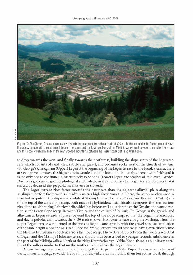
to drop towards the west, and finally towards the northwest, building the slope scarp of the Legen ter-race which consists of sand, clay, rubble and gravel, and becomes rocky west of the church of Sv. Jurij(St. George's). In Zgornji (Upper) Legen at the beginning of the Legen terrace by the brook Svarina, thereare two gravel terraces, the higher one is wooded and the lower one is mainly covered with fields and itis the only one to continue uninterruptedly to Spodnji (Lower) Legen and reaches all to Slovenj Gradec.Due to its geological, geomorphological and hydrological peculiarities the Legen terrace deserves that itshould be declared the geopark, the first one in Slovenia
The Legen terrace rises faster towards the southeast than the adjacent alluvial plain along theMislinja, therefore the terrace is already 55 metres high above [martno. There, the Miocene clays are dis-mantled in spots on the slope scarp, while at Slovenj Gradec, Ti~nica (459 m) and Borovnik (454 m) riseon the top of the same slope scarp, both made of phylitoide schist. This also composes the southeasternrim of the neighbouring Rahtelov hrib, which has here as well as under the entire Gmajna the same direc-tion as the Legen slope scarp. Between Ti~nica and the church of Sv. Jurij (St. George's) the gravel-sandalluvium at Legen extends at places beyond the top of the slope scarp, so that the Legen metamorphicand dacite pebbles drift towards the 8–30 metres lower Holocene terrace along the Mislinja. Thus, theupper Legen terrace was formed to the present height concurrently with the gravel-sand accumulationof the same height along the Mislinja, since the brook Barbara would otherwise have flown directly intothe Mislinja by making a shortcut across the slope scarp. The vertical drop between the two terraces, thatof Legen and the Mislinja Holocene terrace, should thus be ascribed to younger tectonic subsidience inthe part of the Mislinja valley. North of the ridge Krem`arjev vrh–Velika Kopa, there is no uniform turn-ing of the valleys similar to that on the southern slope above the Legen terrace.
Above the Legen terrace and under the ridge Krem`arjev vrh–Velika Kopa, the circles and stripes ofdacite intrusions bulge towards the south, but the valleys do not follow them but rather break through
Acta geographica Slovenica, 48-2, 2008
207
Figure 10: The Slovenj Gradec basin, a view towards the southeast (from the altitude of 630 m). To the left, under the Pohorje (out of view),the grassy terrace with the settlement Legen. The upper and the lower sections of the Mislinja valley meet between the end of the terraceand the slope of Rahtelov hrib. In the rear, wooded mountains between the Pa{ki Kozjak (left) and Ur{lja gora.
IVA
N G
AM
S

Ivan Gams, Geomorphology of the Pohorje mountains
them, just as they break through the intermediate phyllitoid schists, and maintain the southern directionin the higher altitudes and the western direction in the lower altitudes. The above-mentioned circum-stances can be explained in the light of the measurements of recent tectonic uplifting performed on VelikaKopa by means of the satellite (GMS). Established in the 1996–2002 period was the shifting towards thesoutheast with the speed of 0.53 mm per year (Vrabec, 2006). The intrusions can most probably be relat-ed to the origin of the valleys that are curving southeastwards.
On the geological map (as can be seen on the section of Slovenj Gradec), the Lavanttal fault runs oblique-ly across the Quaternary Legen terrace (Mio~, @nidar~i~ 1972). If here too it followed the edge of the rangeof metamorphic rocks, it should turn round the Legen terrace slope scarp. East of Golavabuka two straightvalleys of the Turi~nica and the Dov`anka run again in accordance with the inclination of the slope direct-ly towards the south.
Located two kilometres away from and parallel with the Legen terrace is the 6 km long Plio-Quaternarywooded terrace, the Dobrova. It rises 30 metres above the valleys of the Mislinja and the Suhadolnica with
208
Turi~n
ica
Dov`anka
Porodnica
Rek
a
Barba
rski
poto
k
Krem`arjev
poto
k
Suhadolnic
a
MMislinjaislinjaMM
islinja
islinja
Svarina
Scale/merilo:
0 21 4 km3
Author of contents/avtor vsebine: Ivan Gams
Author of map/avtor zemljevida: Mauro Hrvatin
© Geografski in{titut Antona Melika ZRC SAZU
DEM/DMV: InSAR DMV 25, ZRC SAZU
Krem`arjev vrh
Velika Kopa
Kavnikov vrh
Gradi{~e
Rahtelovvrh
SlovenjGradec
[martno priSlovenj Gradcu
Legen
Podgorje
Stari trg
Pame~e
MislinjskaDobrava
Mislinja
Legen terrace/legenska terasa
Dobrava terrace/dobravska terasa
Figure 11: The Legen and Dobrava terraces.

Acta geographica Slovenica, 48-2, 2008
209
Figure 12: Selective erosion of the Mislinja on the Holocene plain: left – the newly eroded riverbed on the Holocene plain during the floodafter the Second World War.
Figure 13: Right – the old riverbed in which the remaining bigger pebbles are visible, after the smaller particles were swayed away by theflood. The new regulation moved the river into the old bed.
IVA
N G
AM
SIV
AN
GA
MS

Ivan Gams, Geomorphology of the Pohorje mountains
its tributary the Jenina. The geological map in the scale of 1 : 100,000 (the section of Slovenj Gradec) showsthat the Dobrova terrace consists of Plio-Quaternary sand clay and clay gravel with rare intermediate bulkypebbles of the Pohorje rocks. Its southeastern part is 2 km wide and flat on the top. Located there are a ham-let Mislinjska Dobrava and an airfield. Further northwestward the Dobrova terrace, which is narrowedto one kilometre only, rises above the Suhadolnica valley with a very steep slope scarp of upper-Miocenesandstones, marl and cemented rubble. On the opposite side, i. e. the Mislinja side, it gradually lowerstowards the bottom of the Mislinja valley (in the narrower sense of the word).
There are significant differences between the Legen and the Dobrova terraces. In the whole length ofthe 7 km of the Dobrova terrace the inclination of the broad ridge amounts to 1.07 m/km, and in the Legenterrace 12 m/km. They are similar in the fact that in their slope scarps older sediments are dismantled,phyllites in the Legen terrace and the upper-Miocene sediments in the Dobrova terrace.
The Pohorje pebbles that are intermingled in the Dobrova terrace were originally deposited also onthe lower southwestern marginal Pohorje slope. Years ago, in the cart track on this slope between the farms^rnivnik and Mrzel at Golavabuka, a patch of this gravel was dismantled under the slope colluvium, whichcan serve as a proof to the highest Pleistocene gravel accumulation of the Mislinja in the altitude of theDobrova terrace (Gams 1976).
The Mislinja valley (in the narrower sense of the word) extends between the Dobrova terrace and theLegen terrace. Under the Legen terrace, there is a Holocene gravel-sand plain in the valley, where the Mislinjaused to flood after the 2nd World War upon the abandoning of wheat-mills and saw-mills so that the allu-vium accumulated before the dams was transposed. During this process it deposited bigger pebbles inthe old riverbed, while it eroded mainly sand and clay in the new riverbed on the higher Holocene plainand thus performed the selective erosion. The river thus lowered the higher gravel terrace of the [mart-no plain downstream of [martno by 2–3 m, where the Pleistocene Mislinja deposited sand mixed with
210
Figure 14: The Lower Mislinja valley (a view from the southeast); to the right of it, the northwestern Pohorje and Ko{enjak (1522 m) behindit. The straight course, the rather even width and the onetime flood-exposed bottom bear witness to the subsiding tectonic rift. The valleyslightly widens at the end at Oti{ki vrh. At the height of the Würm lake (about 400 m a. s. l.), the (right) Pohorje slope slopes more gentlyand is also more populated on the terrace at Pame~e.
IVA
N G
AM
S

the Pohorje pebbles long up to 38 cm. The length of the largest pebbles consistently decreases betweenthe settlements Mislinja and [martno parallel to the decreasing river gradient (Gams 1976).
At the end of the Lower Mislinja valley up to the altitude of about 395 m a. s. l. the Mislinja was dammedby the Drava with the gravel from the Klagenfurt basin, forming a gravel terrace at the (Me`ica) Dobrova(Kieslinger 1929; Gams 1995). The resultant lake extended to Slovenj Gradec. At the end of the Legen ter-race the tributary Barbara with its alluvium raised the lake level to the altitude of 409 m, which meansup to the altitude of the central town area around the church. The medieval town was protected in thewest by a steep slope scarp at the end of the [martno plain terrace and above the valley bottom of thedammed Suhadolnica. The [martno plain terrace was accumulated by the Pleistocene Mislinja. As dis-closed by recent excavations in the town, the Mislinja in that time deposited finer gravel and a greateramount of sand and gray clay in the area of the town before the lake at the end of the terrace.
Similar circumstances as those at Legen occurred in the Suhadolnica valley. During the Würm cli-max this brook also accumulated a gravel fan, i. e. the Podgorje fan, at its outlet from the narrow valleySuhi dol, in the villages Srednje (Middle) Podgorje and Spodnje (Lower) Podgorje, in the altitudebetween 425 and 440 m a. s. l. The river washed away finer fractions from this gravel fan and depositedthem at the edge of the lake before the town of Slovenj Gradec. Only a narrow terrace remained of thisaccumulation in the suburbs under [tibuh, after larger amounts of it had been carted away. After a long-termexhausting only a short promontory has remained on which the new cemetery of Slovenj Gradec is locat-ed. The sandy and fine gravel alluvium in it is similar to that in the onetime much bigger delta of the Me`aat the bottom end of the same lake at [entjan`, where the excavations were also ended due to the exhaus-tion. The final section of the Holocene Suhadolnica valley between the settlement Radu{e and the Legenterrace is slightly curved westward and rather wide. Proceeding from the supposed fault, as drawn on thegeologic map (the section of Slovenj Gradec), we may conclude that the valley originated as a curved tec-tonic rift.
The surface at the contact of the [martno gravel terrace and the Dobrova terrace is slightly lower andthe waters from the terraces are gathered there in the brook Hom{nica. In its upper section, the onetimerailway embankment and the present main road obstructed its drainage towards the nearby Mislinja. The
Acta geographica Slovenica, 48-2, 2008
211
Figure 15: Near the settlement Oti{ki Vrh the Pleistocene gravelaccumulation of the Drava dammed the Pohorje brook from the riftBavhov graben. Less carbonate and more metamorphic pebbles andsands in it cause poorer solidity. Resultantly, a landslide occurredafter the heavy storm of 1986 and damaged one house and buriedthe lady of the house beneath.IV
AN
GA
MS
Ivan Gams, Geomorphology of the Pohorje mountains
present artificially prolonged brook resultantly floods downstream the fields and cellars even more fre-quently (Gams 1992).
The rather poor knowledge of geology of the Slovenj Gradec basin was improved by The GeologicalSurvey of Slovenia by means of a 1000 m deep well that proved to be a failure as to the pumping of ther-mal water near the abandoned town heating plant at the northern end of the Dobrova terrace. To the southof this well, there is a bigger plane on the top of the terrace at the altitude of 450 m a. s. l. which steeplyrises above the settlement Curava vas. With a steep slope scarp it lowers towards the south, the north-west and the north; at the latter location the above-mentioned well was made. According to the detailedreport of the Geological Survey of Slovenia (Poro~ilo 1990) the well in the [tibuh terrace revealed (to putit simply):• 2–56 m: gravel with clay cement; the Plio-Quaternary;• 57–208 m: sandstones, strata of conglomerates, marls and silt; the Miocene;• 209–264 m: light-gray dolomite, the Anisium or the upper Trias;• 265–378 m: dark-gray dolomite, clay schist and tuffa; the Paleozoic, the lower Trias;• 379–1000 m: metamorphic complex; the Paleozoic.
Based on the composition of the well, an attempt is presented here, to make the chronology of thegeomorphological development of the triangular Slovenj Gradec basin. The Triassic sediments, mainlythe 169 m thick dark-gray Triassic dolomite, are thrusted on the Paleozoic metamorphic rocks 400 m fromthe present northern rim of the upper-Miocene strata from the foothills of the Karavanke under which,in the nearby Podgorje and in the surroundings, the thrusting of the Karavanke towards the north hasbeen proved by coal excavation in the mine at Le{e, too.
The 151 m thick upper-Miocene strata indicate the intensive subsiding of the Slovenj Gradec basin.They are dismantled at Dobrova in the terrace slope scarp only along the valley of the Suhadolnica andits tributary Jenina; furthermore, they compose a wide belt in the valley system at the foot of the Karavankeand of the Pohorje all the way to Slovenske Konjice. Also on the ridge of the northwestern Pohorje in theReka drainage basin they have remained as a 5 km long belt. This corroborates the thesis that the Eibiswaldstrata of the Kobansko were linked across the Pohorje with the strata of equal age at the foot of the Karavanke(Sölva 2005). To the west of Stari trg, there is the lowest, one hundred metres high saddle in the hills whichlinks the basin with the Sel~nica valley. In this direction the Mislinja supposedly ran in the time when thepresent upper and lower sections of the Mislinja valley were not yet connected with a single river. The54 metres of the Plio-Quaternary sediments in the well indicate the continued subsiding of the basin.
4.7 The northwestern Pohorje
The northwestern Pohorje belongs to the Kobansko geological series as to the sediments, and is the mostvariegated part of the Pohorje in terms of lythology. In the higher altitudes of the (Trbonje) Reka drainagebasin the Eibiswald strata occupy the 5 km long island, and all other Pohorje rocks occur here. At the water-shed, too, the elevations are semicircular without a straight divide between the Mislinja and the Reka, andwithout the features typical of the rest of the range. The range between the Mislinja and the Reka widenstowards the northwest, where it ends above the Drava valley with a long and undissected ridge.
4.8 The Pohorje plateau
The Pohorje plateau is about 10 sq km large plateau on the ridge of the Pohorje in the altitude between1150 and 1300 m a. s. l. Its origin might date from the time of the surrounding equally high base level.The latter could have been sustained at its northern and southern sides of the range by the cover of theupper-Miocene strata, at the eastern side possibly also by the area of muscovite-biotite-gneiss of whichthe isolated mountain Veliki vrh (1344 m) has remained. The Lobnica, into which the majority of waterfrom the plateau drains at present, was not capable of a more intensive regressive erosion, because its out-flow in the Lovrenc valley system had been higher before the westward sinking of the Drava valley reachedit. Erosion in the Bistrica drainage basin is paralysed by scarce precipitation. Else, the erosion along thewatershed is poorer as a rule. Running across the plateau is the watershed between the Plesi{~ica beinga tributary to the Radoljna, the Lobnica and the Oplotnica.
212

5 The intensity of geomorphological processes
Chemical erosion is significantly lesser than denudation and erosion. In its upper horizon, the moder-ately to very acid soil on the metamorphic rocks has the values of pH between 4.6 and 5.5, in the northeasternsection of the range partly below 4.5, in the Western Pohorje, 5.6 to 6.5, and the soil here is of the rendz-ina type (Gr~man 2004). Lying on the andesite is ranker with shallow soil. The acid soil could providegood conditions for chemical solution, but the carbonates are only scarce there; as much as they do occur,they are mainly tiny intrusions in the metamorphic rocks. Igneous and metamorphic rocks contain, onthe average, only 1.5 to 4% of MgO (Hinterlechner-Ravnik 1973; Faninger 1973; Mio~, @nidar~i~ 1972).
Also on steep slopes, metamorphic and veined rocks on the Pohorje are covered with thick sandy soilwith little clay admixtures, so precipitation water easily permeates through it down to the rock basis. Itserosion is obstructed on the surface by densely interlaced roots of grass and trees, mainly of spruces whichcover the surface now. The conclusion that the roots of deciduous trees were shallow under the surfacein the geological past even before the phase of spruce is possible on the grounds that the largest amountsof humus occur there. Rill erosion occurred on the slopes until recently in places where people destroyedthe cover turf and roots along the timber transport ruts. Timber transport down the steep slopes has sig-nificantly declined since the motorways were constructed. However, rill erosion on cart tracks still occurson the gently sloping Quaternary terraces. On the steep slopes of the higher Quaternary terraces in theDrava valley landslips occur and, after the storms, landslides as well (Gams 1987). Downward translo-cation of soil during the ploughing of the slope fields on the Pohorje used to result in landslips and steepbottom edges, the steepnes of which has been mainly reduced by now. However, also at some places onthe Pohorje, like elsewhere (see Komac 2005, Fig. 4 and 5), the increased impact of steepness on erosionis evident, especially on steep meadows and on the rare remaining fields (Gams, 1959). Landslips are more
Acta geographica Slovenica, 48-2, 2008
213
Figure 16: The wooded eastern edge of the Pohorje plateau, a view from the peak Rogla. Right: upper end of the Oplotnica rift and Velikivrh (1344 m); left: the ridge of the Maribor Pohorje in the rear.
IVA
N G
AM
S

Ivan Gams, Geomorphology of the Pohorje mountains
214
Figure 17: Stones of granodiorite in the cart track west of, and 30 m below, the peak Jezerski vrh (1537 m). Granodiorite contains 2–3% ofaluminium oxide (Mio~, @nidar~i~, 1972).
IVA
N G
AM
S
Figure 18: The polished oviform boulder – the photo was taken in the 1950s by the then not yet asphalted road 2 km northwest of [martnona Pohorju. The boulder was familiar to the locals, but was later removed. Its polished surface might have been the result of solution at thecontact with acid soil.

frequent on fine-grain sediments of the Eibiswald strata. Only six landslides are drawn on the geologicalmap in the scale of 1 : 100,000 (the section of Slovenj Gradec), all in the hills between Lovrenc and Fala,where the rock basis is tectonically shattered due to the progressing Selnica rift.
The speed of the recent uplifting of the surface on the highest part of the Pohorje, as calculated fromthe repeated measurements of nivelman points, is exceeded in Slovenia, according to Jovanovi} (quotedin Premru 2005, 338), only in the Triglav mountains and in the centre of the Kamnik Alps. On the Pohorje,it amounts to 4.3 mm/year up to the altitude of 1200 m, and 6 mm/year in higer altitudes. The age of themountain uplift can be calculated from these data, provided that the uplifting was even all the time andbegan at the altitude of 300 m a. s. l. According to this calculation, the uplift of the mountains is about260,000 years old, which means that it began in the Mindel-Riss interglacial stage. However, a slower uplift-ing at the beginning and its uneven speed throughout should also be taken into account.
The Hydrometeorological Institute of Slovenia has so far been the only one that measured the bear-ing away of the sediments on the Pohorje, but without suspension in the water and river gravel. Themeasurements were performed in the years 1971 and 1972 on two locations, in the Ho~ki potok and inthe river Bistrica. The validity of findings was prolonged by establishing the following issues at the sur-rounding precipitation-measuring stations: the average frequency of years as dry as was the year 1971,and the frequency of years as wet as was the year 1974, as well as the annual average number of days withover 40 mm of precipitation and the number of days with over 20 mm of precipitation per day (measuredin the 1961–72 period). Kolbezen (1979) states that there is but little suspension in the measured brooksand there is also but little gravel in the riverbeds. The average lowering of the surface in five drainage basins,calculated on the above-stated basis, amounts between 0.11 and 0.21 mm per year. In the Ho~ki potokdrainage basin, which consists of gneiss and where many houses, gardens and other things related to tourismon the Maribor Pohorje have been built in recent years, the calculated lowering amounts to 0.27 mm/year,while in the Bistrica drainage basin it amounts to only 0.02 mm/year. Proceeding from this the conclu-sion is that in a million years the surface would lower by 110 m on the average, and specifically by 270 min the Ho~ki potok drainage basin and by 20 m in the Bistrica drainage basin. Not taken into account inthis calculation was the transport of gravel which was strongly intensified in the ice-age.
According to the table of the hitherto measurements in Slovenia, the erosion measured in the Ho~kipotok is similar to the highest erosion measured in Slovenia so far, which was in a vineyard (the Rokavadrainage basin). And the stated amount for the Bistrica matches the average loss of soil due to erosionon the agricultural areas of Slovenia (Komac, Zorn 2005, 79). In the narrow upper section of the Bistricadrainage basin, the surface of the eastern Pohorje inclined plateau in the zone of granodiorite is more dense-ly wooded and sloping more gently than on average in the mountains, according to the stated measurement.
The transport of dissolved minerals, which was more abundant in the warm Pliocene, is not takeninto account in the above-mentioned calculations. Besides amphybolites, there are some other slightlysoluble minerals (e. g. eclogite – Mio~, @nidar~i~ 1972, 20) on the Pohorje. In the headwaters of the Polskavabrooks there are stripes of marble from which rocks break off and roll down the slope (@nidar~i~, Mio~ 1988).Corrosion is reduced on the eastern Pohorje by the small precipitation amount (1179 mm, [martno naPohorju), of which 650–700 mm evaporate annually, so that only 529 to 579 mm remain for drainage. Alsofor this reason, of all of the parts of the Pohorje the eastern Pohorje slope has retained to the greatest degreethe original altitude and the image of tectonically obliquely inclined plateau.
Erosion was increasing parallel to the uplifting of the Pohorje. In view of the fact that a great portionof the present erosion occurs on the cleared, non-wooded and agricultural areas, the calculation of ero-sion-caused lowering on the grounds of the current conditions is questionable in establishing the relieflowering in the time before the human settling. Denser settling on the southern Pohorje took place in theNeolithic and the Eneolithic, i. e. 7000–3500 years B. C. ([ercelj 1996, 72).
The gradient of the Pohorje streams, which indicates the erosion potential, is influenced by many fac-tors, among them also by the yearly precipitation amount and the speed of tectonic uplifting of the mountainsand/or the subsiding of the basins.
It is evident from the table and Figure 19 that the gradient, as an important factor of erosion, essen-tially depends on the length of the stream (and thus, indirectly, also the discharge). A short course meansa high gradient. The gradients are the highest in the Polenica, i. e. in the Paka headwaters, and on the north-western Pohorje in the short but torrential Laku`nica which, a few decades ago, still endangered the roadtransport at the bottom of the Spodnja (Lower) Mislinja valley with its alluvia in the form of aggraded riverbed.
Acta geographica Slovenica, 48-2, 2008
215

2 4 6 8 10 12 14 16
400
600
800
1000
1200
1400
1600
Ostru{~icaLovren{ka jezera
Radoljna
Lovren{kopodolje
Rde~iBreg
Fakovkogel
2 4 6 8 10
Lenght (kilometers)/dol`ina (kilometri)
Lenght (kilometers)/dol`ina (kilometri)
400
600
800
1000
1200
Ela
vati
on
(m
eter
s)/
nad
mo
rsk
a vi
{in
a (m
etri
)E
lava
tio
n (
met
ers)
/n
adm
ors
ka
vi{i
na
(met
ri)
Po`arnica
Krem`arjevvrh
Drav~e
Mr{akovvrh
[tihovvrh
[entjan`nad Drav~ami
Ivan Gams, Geomorphology of the Pohorje mountains
216
Figure 19: Graphical presentation of the selected Pohorje brooks.
2
400
600Sv. Peter na
Kronski gori
Bauhovgraben
Lenght (kilometers)/dol`ina (kilometri)
Ela
vati
on
(m
eter
s)/
nad
mo
rsk
a vi
{in
a (m
etri
)
2 4
600
800
1000
1200
Turi~nica
Velika Kopa
Razborca
Dov`e
Lenght (kilometers)/dol`ina (kilometri)
Ela
vati
on
(m
eter
s)/
nad
mo
rsk
a vi
{in
a (m
etri
)

Acta geographica Slovenica, 48-2, 2008
217
2 4 6 8 10
800
1000
1200
1400
1600
Gla`uta
Mislinja
preval[iklarica
^rni vrhJezerski vrh
Mislinja
Kri`evskivrh
Lenght (kilometers)/dol`ina (kilometri)
Ela
vati
on
(m
eter
s)/
nad
mo
rsk
a vi
{in
a (m
etri
)
2 4 6 8 10 12
400
600
800
1000
1200
Per{etovvrh
Smre~no
O{elj
ZgornjaBistrica
ZgornjaNova vas
Bistrica
Lenght (kilometers)/dol`ina (kilometri)
Ela
vati
on
(m
eter
s)/
nad
mo
rsk
a vi
{in
a (m
etri
)

Ivan Gams, Geomorphology of the Pohorje mountains
Table 1: Gradient of selected streams and precipitation
Water stream Altitude a. s. l. Altitude a. s. l. Length Gradient Yearly precipitation Period Meteorolo-gicalof the source of the mouth in km in m/km in mm station
Polskava 1000 294 14,5 55,6 1179 1961–1990 [martnoDevina 830 277 9,5 66,6 1043 1961–1980 Slovenska
BistricaOplotnica 1420 379 15,0 70,0 1174 1961–1990 TinjeHudinja 1380 482 9,5 94,5 1517 1961–1990 RoglaPaka – Polenica 1280 600 3,6 188,0 1245 1961–1990 MislinjaMislinja – Mislinjski jarek 1440 605 19,5 69,1 1245–1527 Mislinja, Rogla,
podatki za 10 letTuri~nica 1325 560 6,0 126,7 1245 1931–1960 MislinjaLaku`nica 695 370 2,8 420 1334 1931–1990 Gradi{~eVuzeni{ka Reka 935 335 10,5 57,1 1132 1961–1990 [emprimo`Radoljna 1460 400 12,0 88,3 1627 1925–1940 Stara Gla`uta^rnava – Lobnica 1260 1100 3,6 44,4 1627 1925–1990 Stara Gla`utaLobnica* 1100 275 11,2 73,7 1627 1925–1990 Stara Gla`utaMislinja – Mislinja 600 332 21,0 12,8 1156 1961–1990 [martno pri
Slovenj GradcuDrava between Dravograd 337 288 (49) 1,09 1135 1961–1990 Dravograd
and Fala
* The initial Lobnica tributaries on the Pohorje plateau have much lower gradient than the river on the northern slope. The gradient of thetributary ^rnava to its confluence with the Majland amounts to 36 m/km, and of the Lobnica on the steep slope to its confluence withthe Drava, 96 m/km. The length of the stream means the air distance between the beginning of a temporary or permanent stream andthe edge of the range.
For the same reason as mentioned above, the gradient of the short brook ̂ rnava is also low. The Turi~nicaand the Dov`anka have high gradients due to the neotectonic subsiding of the Slovenj Gradec basin andconcurrent uplifting of the Pohorje. The gradient of the Lobnica (without its tributaries from the plateau)is high. If the Oplotnica tributary from under Rogla is not taken into account, the gradient of the Oplotnicabetween Jurgovo and the settlement Oplotnica amounts to 69 m/km, which is less than the gradient ofthe Radoljna slope stream which receives a greater amount of precipitation. The low gradient of the Mislinjain the upper and the lower Mislinja valley results from both the more abundant water and the neotec-tonic subsiding of the valley.
The analysis of forms of drainage basins as they are drawn on the isohypse map shows the unambiguousdifference between the wide and long drainage basins on the northern Pohorje slope between the valleysof the (Trbonje) Reka and the Oplotnica, and the drainage basins lying on the younger southern Pohorjeslope. The valleys are the narrowest above the lower section of the Mislinja valley, which was subsidingparallel to the Lavanttal fault in the Plio-Quaternary, and in the Slovenj Gradec basin in the continua-tion of the sub-Karavanke rift or the Kotlje valley system. The erosion of the Pohorje brooks in the Doli~valley system was intensified by two recent breakthrough valleys, one at Huda luknja and the other belowVitanje, while before that the high base level was maintained by the Pa{ki Kozjak. The area of narrow val-leys also includes the inclined eastern-Pohorje plateau and the Maribor Pohorje above the Selnica valleysystem. Prevailing north of the central Pohorje are the narrow drainage basins of the Drava tributarieswithin the scope of the Drava Pohorje.
5.1 The Pleistocene glaciation on the Pohorje
There were no substantiated proofs to the Pleistocene glaciation on the Pohorje ridge all untill recent-ly. Melik (1957, 36) wrote, that »… moors with lakes (author's note: i. e. gently sloping locations belowmountain summits on the Pohorje plateau and the ridge to Jezerski vrh) … were here the result of the dilu-vium glaciation; on gently sloping locations below mountain summits short lateral glaciers developed,and shallow slope depressions were formed under them, and in the latter, lakelets and moors developed …Possibly, the peri-glacial processes contributed considerably to the formation of this surface …«.
218
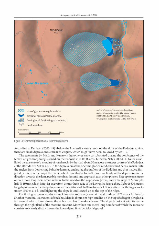
According to Kunaver (2000, 49) »below the Lovren{ka jezera moor on the slope of the Radoljna ravine,there are small depressions, similar to cirques, which might have been hollowed by ice …«.
The statements by Melik and Kunaver's hypotheses were corroborated during the conference of theSlovenian geomorphologists held on the Pohorje in 2005 (Gams, Kunaver, Natek 2005). K. Natek estab-lished the existence of a moraine of rough rocks by the road about 50m above the upper course of the Radoljna,at the altitude of 1220 m a. s. l. In the depression at the onetime glacier's end, there had been a marsh untilthe anglers from Lovrenc na Pohorju dammed and raised the outflow of the Radoljna and thus made a fish-pond, Jezerc (on the maps the name Ribnik can also be found). From each side of the depression in thedirection towards the dam, two big moraines descend and approach each other pincers-like; up to one metreor even more long rocks occur in them. In the wood on the slope above Jezerc, under the ridge of Mraveljskihrib (1480m), which is not far away from the northern edge of the Lovren{ka jezera, there is about 600 metreslong depression in the steep slope under the altitude of 1400 metres a. s. l. It is scattered with bigger rocksunder 1300 m a. s. l., and higher up the slope is undissected up to the top of the ridge.
On the higher, wooded slope one kilometre south of Jezerc at the altitude of 1271 m a. s. l., there isanother moraine. Its crescent of rock boulders is about 5 m high and lies on the top of a bigger periglacialfan around which, lower down, the valley road has to make a detour. The slope brook cut with its ravinethrough the right flank of the moraine crescent. More than one metre long boulders of which the moraineconsists are clearly distinct from the lower-lying finer periglacial gravel.
Acta geographica Slovenica, 48-2, 2008
219
1500
1500
1450
1400
1350
1300
1250
1200
1150
LoLovren{ka jezvren{ka jezereraa
Radoljn
a
ribnik
Mramorskivrh
size of glaciers/obseg ledenikov
terminal moraine/~elna morena
fluvioglacial fan/fluvioglacialni vr{aj
boulders/skale
Scale/merilo:
0 300150 600 m450
Author of contents/avtor vsebine: Ivan Gams
Author of map/avtor zemljevida: Mauro Hrvatin
© Geografski in{titut Antona Melika ZRC SAZU
DEM/DMV: InSAR DMV 25, ZRC SAZU
Figure 20: Graphical presentation of the Pohorje glaciers.

Ivan Gams, Geomorphology of the Pohorje mountains
220
Figure 21: A little under the altitude of 1300–1400 m a. s. l., above the southern glacial depression, the cover of periglacial rubble begins,from which here and further to the south numerous brooks take their source which, downstream, deepened their riverbeds in places to therock basis.
Figure 22: More to the south and higher up, above the new cart-track on the western slope of the ridge Lasina (1412 m)–Pesek (1423 m),there are the dismantled, supposedly cryoturbatic folds of the weathered sandy material.
IVA
N G
AM
S

The answer to the question of why the big rocks, accumulated in the about 70 m wide depression onthe slope above Jezerc, have not rolled down into the moraine depression and filled it is offered by thecourse of the last ice age. At the beginning of the Würm glaciation, precipitations were more abundantand snow in the mountains was more abundant, too. Between the years 35,000 and 12,000, dry climateprevailed in Central Europe, with the temperatures lower by 10 °C and lesser precipitation by about 500 mm(Frenzel, Velicko 1992). Consequently, the glacial transformation of the Pohorje surface was replaced byperiglacial transformation. The rocks above Jezerc might have originated in this time and were soon pre-vented from rolling down by the trunks of forest trees. The depression above the southern moraine isshallower and narrower and it is rather a deepened and widened long valley of a brook which takes itssource higher up in the slope and still runs permanently. Both here and in the wider southern slope, inthe altitude of about 1400 m a. s. l., several periodical brooks take their source from the bottom edge ofthe slope cover of coarse periglacial gravel. The shallowness of the depression above the southern moraine,as it is above Jezerc, is also the result of the short-lasting existence of the glacier.
Above the valley-depression of the two glaciers is a slope, up to 150 m high and covered with grass atpresent, which was not corrugated by glacial or periglacial processes.
It is believed that the cause why only the eastern slope at the northern end of the 5 km long and almostevenly high ridge northwest of Ostru{~ica (1498 m) was glaciated lies in the more abundant snow pre-cipitation in the proximity of the saddle [iklarica (1299 m).
The composition of periglacial gravel on the western slope of the ridge with the peaks Lasina (1412 m)and Pesek (1423 m) is most clearly seen on the new roadway towards Jezerc, which branches from the mainroad from Lovrenc south of its juncture with the local road. The macadam road runs on the valley slopeof the right Radoljna tributary. In the recently dismantled gravel, up to one metre big stones initially occur,equally rounded as those in the vicinity of the Radoljna riverbed. This means that the upper valley of theRadoljna was filled with gravel up to this height at that time, and on this gravel an ever thicker cover ofperiglacial sand was deposited which lies directly on rock basis in higher altitudes. Where the sandy soilon the slope more to the south is moist, the cryoturbatic folds have been formed in places. The road ascend-ing towards the south along the valley of the Radoljna and leading to Ko~a na Pesku soon reveals ever
Acta geographica Slovenica, 48-2, 2008
221
Figure 23: A view from the northeast of the 2.5 km long fluvioglacial fan and on it, above the terrace slope scarp, the prolonged settlementLovrenc na Pohorju. Above the remote northern slope in the drainage basin of the Radoljna the clouds seem to start gathering first.
IVA
N G
AM
S

Ivan Gams, Geomorphology of the Pohorje mountains
shorter pebbles. Between Mulejev vrh and the Sedlo Komisija, there is a vast terrace made of sand andonce transformed into meadows; the sand also gave the name to Ko~a na Pesku (means Hut on the sand).
That the glaciers were formed only on the eastern slope of the northern end of the ridge with theLovren{ka jezera on the top, most probably resulted from the local climatic conditions. The deep valleysof the Radoljna and its tributary Plesi{~ica, separate the Pohorje ridge slope by several kilometres and unitethe prevailing winter northeastern cold air masses from the Pannonian basin – where the loess steppe pre-vailed during the coldest Pleistocene periods – and direct them towards the southwest, i. e. towards thelowest saddle, the Sedlo Komisija, in the direction towards the Mediterranean basin. Heavy rainstormsin the Radoljna drainage basin still cause floods and damages ([eme 1994). Glaciers were not formed onthe Sedlo Komisija at the northern end of the Mislinja rift, because the altitude was too low (1299 m).The [iklarica between Jezerski vrh (1537 m) and Planinka (1420 m) is the lowest saddle in the 18 km longPohorje ridge between Mala Kopa and Rogla. The closest to it was the meteorological station Stara Gla`utawhich recorded the greatest annual precipitation amount on the Pohorje (1925–1940: 1627 mm), whichis more than on the higher Rogla above the southern edge of the Pohorje plateau (1517 mm).
Poorly rounded, up to half a metre long boulders were deposited by the Radoljna also in the area ofthe settlement Lovrenc na Pohorju, which extends with its buildings and cultivated areas over the 2.5 kmlong gravel-sandy fan. Regrettably, the longest boulders in the entire Pohorje foothills are no more dis-mantled in the onetime gravel pit above the tributary Slepnica.
5.2 Peat bogs and lakes on the Pohorje
Peat bogs on the Pohorje plateau are another Pohorje particularity. The area of peat bogs lies betweenAdamov vrh (1260 m) and Pesek (1427 m). In between the wet little valleys round elevations rise, whereperiglacial rubble base is dismantled locally on the slope from under the soil in the road cuts as a proofto the statement that the periglacial geomorphological processes dominated on the plateau in the Pleistocenecold periods.
222
Figure 24: In the marshy basin named Radovina, two spruces were uprooted and thus the remains of the former tree in the peat basis onthe Pohorje plateau were disclosed. Despite the lee position in between the surrounding woods, wind-devastations are obviously efficienthere, on the marsh.
IVA
N G
AM
S

In such circumstances the slid slope gravel can raise the water table at the transition to the plain, andcauses that the area becomes boggy. According to another hypothesis, the boggy area is the result of theso-called periglacial nivation basins, which are frequent now in the sub-Arctic climate (Gams, Kunaver,Natek 2005). But these are bigger than those on the Pohorje plateau. On a more detailed map peat bogsin stripes can also be established in the planes. Such cases can be found especially in the northwesternand eastern rims of the plateau. In places, the longitudinal profile of the brooks is divided to sections onmossy basis in between a few spans high dams of the accumulated moss below which pools lye. The largestpeat bogs occur in the basin-like beginnings of the confluent brooks. There, they were most intensely changedby people. The marsh of Tiho jezero has another name on the maps, Falski ribnik (the Fala fishpond),which points to the anthropogenic damming of the outflow, just as centuries ago the Lovrenc anglersdammed the marsh in the above-mentioned moraine basin Jezerc. A marsh was also dammed with earthdam to become the lake ^rno jezero in order to obtain more abundant water for wood rafting along theshoot in the Lobnica valley on the northern slope of the mountain (Gams, 1962). General marshiness andthe resultant development of peat bogs on the plateau increase towards the northwest, i. e. towards Klopnivrh, which means in the direction of increasing precipitation amount.
The warmer Pliocene and Holocene boreal climates with deciduous trees were most likely not favourablefor peat generation because deciduous trees need more water than conifers that grow in the area now.The human impact on the change of the forest has not been established yet. Apparently, the bogginesshas increased after the present cover of conifers prevailed, especially after the forest was cleared and pas-turing invented, and after the earliest burning of forest caused by lightnings and shepherds. In the past,the Pohorje locals used to burn forests on mountains to gain pasture lands. Due to the remoteness of theridge plateau from the valley transport routes wood was not worth felling and being transported to thefoothills all until the end of the 19th century. In the 18th and the 19th centuries the cheap wood for char-coal production on the top of the mountains attracted iron foundries (at Mislinja and at Lovrenc) andmore recently on the northern slope glass-works in particular. Slightly below the Pohorje plateau sixglass-works operated which required huge amounts of charcoal. On the plateau's clearances, they haveleft behind grassy and boggy lands. There and in other thin forest associations in the surroundings main-ly the farmers from the Vitanje- and the Zre~e Pohorje used to pasture their cattle. In the feudal timesand later on, the Pohorje plateau was owned by the Fala manor lords, who leased, for example, in theyear 1886 more than 600 hectares of lands for the pasturing of 678 head of cattle. Later on, when the lordsof the manor tried to prevent pasturing because it had supposedly increased the bogginess, the farmersappealed to the old right (Hiltl 1993). The lawsuit between the farmers and the present forest manage-ment has not been thoroughly settled yet. On the tops of the ridges on both sides of ^rni vrh (1543 m),Jezerski vrh (1537) and east of [iklarica the forests have not overgrown mountain meadows yet, becausefarmers from the Lovrenc surroundings still pastured there all until recently. Occurring on the maps forthe top of the ridge east of [iklarica are two names, Planinka and ^rna mlaka (Black pool), where cattlewas watered. Improved knowledge about the peat bogs on the Pohorje plateau can be expected from theforthcoming modern dating of peat.
There is another particularity on the Pohorje: the lakes in the area of Lovren{ka jezera and the lakesin the area of Ribni{ko jezero, both on the top of the ridge. Palinological researches were done into bothof the areas. At Lovren{ka jezera, Budnar (1958) established a 60 cm thick layer of sand under the 240 cmthick peat, and she found out that the moor began to be formed in the Holocene early warm or borealphase, or in the hazel tree phase, approximately 6000 years ago. With the C
14dating method the age of
a hundred years was recently attributed to the sediments in the depth of 14 cm, considering the balancedgrowth of the surface peat (Brancelj, 1999). More thorough pollen researches revealed the following devel-opment by layers: –260–240 cm: hazel, spruce and fir; –240–220 cm: beech, fir, spruce; –220–150 cm: beech,fir, spruce; –150–130 cm: spruce, fir, less beech; –130–60 cm: peat mud; –60–0 cm: peat moors, lake sed-iment, spruce pollen increases. The early sediments supposedly date from the Atlantic phase 7000–8000 yearsago (Culiberg, 1986). The same author has also published the pollen analysis of the Ribni{ko jezero: depth300–290 cm: peat with tonalite gravel, spruce and over 50% of hazel; 290–255 cm: hazel phase, alder;255–200 cm: increase in fir and especially beech and hornbeam; and at 245 cm: grasses, age 4080 ±130 years;200–100 cm: increase in spruce and fir, beech; 100–50 cm: intensified spruce and fir; 50–0 cm: increasein pine.
Acta geographica Slovenica, 48-2, 2008
223

Ivan Gams, Geomorphology of the Pohorje mountains
According to these measurements, the area of Lovren{ka jezera is about 3720 years old, and the mooraround Ribni{ko jezero about 4080 year. Responsible for the decline in the share of beech and fir seemsto be the human impact. The common finding is: the two moors are not the result of the Pleistocene, sincethe two accumulations began in the Atlantic phase (7000–8000 years ago) or later (Culiberg, 1986). Forestsof beech and fir still prevailed on the Pohorje 7000 years ago, while spruce has supposedly prevailed inthe recent times only. Visible local anthropogenic impacts on the Pohorje forest can be traced from theNeolithic onwards (Culiberg, M., A. [ercelj, 2000). The finding that the formation of peat began in theHolocene early warm or boreal phase is surprising, because the evapotranspiration of vegetation is alsohigher with higher temperatures, which means lesser ground moisture.
The area of Lovren{ka jezera and the area of Ribni{ko jezero do not have quite equal positions. Theformer lies at the northern rim of the rounded ridge Rogla–Planinka in the altitude of slightly above 1500m.Without the forest or grass cover, as was the case in the time of glaciation, sand in the basis would havebeen blown off by the wind. Up to 40 cm deep depressions in the areas of Lovren{ka jezera and Ribni{kojezero lie on the very watershed ridge, where the underground water from the peat surroundings can flowfrom all the sides. Due to such a position the lakes do not dry out in summer. The largest lake, Ribni{kojezero, is also on the plain but, in contrast to the lakes of Lovren{ka jezera, it lies on the about 150 m wideplateau east of Jezerski vrh (1537 m), so that on the southern side, amidst dwarf pine, there can also besome minor water »windows« (Gams 1962). On the top of the ridge Rogla (1517 m)–Planinka the marshi-ness intensifies in the direction of precipitation increase, i. e. towards the north. Above [iklarica, there isa marshy grass ridge rising eastwards, called Planinka and marked on the maps as ^rna mlaka.
6 On the special feature of the geomorphological researchesinto the mountains of the Pohorje type
6.1 Ridges and valleys as indicators of geomorphological development
Longitudinal profiles of the ridges between two neighbouring valleys were made in order to assess to whatdegree they still reflect the original surface level into which erosion had deepened the valleys. On thenon-rocky ground, the precipitation water does not run off on the surface but under the surface throughthe weathered material and, thus, the top of the ridge is lowered by soil processes mainly. The more intensivebearing away of rock mass begins lower down on the slope where the sources of temporary and perma-nent streams occur and erosion comes into force.
The tops of the ridges of metamorphic rocks run much straighter than those of the Eibiswald stratabetween Ribnica and the Vuzenica basin, because they consist of the petrographically mixed materials (seelongitudinal profiles of the ridges). The table below shows only a sample case of each geomorphologicalunit.
Table 2: Length and gradient of the selected Pohorje ridges, typical of the mountains
The Pohorje region Beginning of ridge (altitude in m) End of ridge (altitude in m) Length km Gradient m/km
Northeastern Pohorje Krem`arjev vrh 1164 Drav~e 380 12,6 62,2Lovrenc Pohorje Klopni vrh 1340 Lovrenc 436 8,0 113,0Eastern Pohorje Per{etov vrh 1242 Zg. Bistrica 242 14,1 71,4Vitanje Pohorje Kraguli{~e 1454 Vitanje 460 10,0 99,4Upper Mislinja Pohorje Velika Kopa 1543 Dov`e 575 7,2 134,4Lower Mislinja Pohorje Golarjev vrh 834 [entjan` 358 3,8 125,3
The peaks of the ridges in the longitudinal direction are the steepest: Razborca above the upper Mislinjavalley, (Velika Kopa–Dov`e, 134 m/km), the lower Mislinja valley (Golarjev vrh–[entjan`, 125 m/km), theridge above Lovrenc (Klopni vrh–Lovrenc, 113 m/km). The three above-mentioned cases manifest thetectonic subsiding at the foothills. Therefore, the final part is also the steepest, which means the bottomsection of the profile above the fault in the valley at the rim of the mountains. Moderate gradient occurson the Vitanje Pohorje (Kraguli{~e–Vitanje), with the average inclination of 99 m/km, which is slightly
224

less than above Dov`e and above Lovrenc. The profile Krem`arjev vrh (1154 m)–Drav~e (by the Drava,372m) runs along the ridge between the brook Po`arnica, which is the Plav`nica tributary, and the (Trbonje)Reka. It is long, the least steep and runs initially on dacite, then on flint sandstones, and finally on phyl-litoid schysts. Its heights above the two valleys oscillate the most in the Eibiswald strata, which consist ofhard cemented sandstone, marl and conglomerate. Located on sandstones, or just near the mound madeof them, are two parish churches with a fine view, Sv. Primo` (St. Primus's) and Sv. Anton (St. Anthony's).The average gradient of the Vuzenica brook Plav`nica is 134 m/km. Low gradients also occur on the east-ern Pohorje plateau Per{etov vrh–Zgornja Polskava. We can draw a conclusion that of all the landformsthe Pohorje ridges are the least lowered and altered surface.
On the Drava Pohorje, the peaks in between the breakthrough valleys along the brooks from the Pohorjereach the following altitudes: Jan`evski vrh 912m, the western Hlebov vrh 913m, the eastern Rde~i breg 793m.This fact points to the origin of the majority from the ridge with the summits between 800 and 900 m a. s. l.The lower Ruta (Lobnikov vrh, 705 m) is closer to the subsiding end of the valley system above Fala.
Until Razborca in the southeast of the Mislinja drainage basin, the Pohorje ridges begin at 200–300 mbelow the watershed ridge. But there are no side ridges on the Pohorje along the 2.3 km long and wideridge with the highest peak Me`narjev vrh (861 m), which rises semicircularly over the breakthrough val-ley of the Drava between the settlements Me`a and Trbonje. This is the only Pohorje slope which approachesthe limit of instability or the crumbling of rocks. The ridge spans between the settlement Me`a and theelevation with the point 792 m under Me`narjev vrh (861 m); it consists of phyllitoid schist. On the mapin the scale of 1 : 50,000, a sole torrent ravine is drawn on the higher slope, while the rest is mainly a rockyslope with the average inclination of 40° with the prevailing mechanical weathering of rocks. During extremerainstorms and at high snow, the fallen stones and avalanches used to block the traffic on the railwayMaribor–Dravograd.
Acta geographica Slovenica, 48-2, 2008
225
Figure 25: In the upper Legen, the rock at the bottom of the valley, running parallel to the strike-slip fault, is tectonically broken to piecesand the barren slope is unstable.
IVA
N G
AM
S

Ivan Gams, Geomorphology of the Pohorje mountains
The development of a drainage basin is also influenced by the ground water capacity, resistance toerosion and specific run-off, therefore the usual establishing of its development or its age from the ratiobetween the tributaries of different ranks is not the best criterion. Of particular importance in our caseof the rather homogeneous resistance to erosion is the ratio between the length and width of the drainagebasin. Parallel to the increase in the depth of the river valley, the tributaries are also longer, which widensthe drainage basin. So, older river basins are therefore wider. According to this criterion, the oldest Pohorjedrainage basins occur on the northern slope between the (Trbonje) Reka in the west and the Lobnica inthe east, and on the southern Pohorje they are also the Mislinja rift and the Dravinja drainage basin. Theyoungest in this respect are the drainage basins of the Mislinja tributaries northwest of the settlement Mislinjaand those on the Maribor Pohorje between the (Drava) Bistrica and the brook Framski potok. The causeof it can also be searched in the subsiding of the Mislinja valley, the Drava valley and the Dravsko poljeplain, and the young uplifting of the watershed ridge on the Maribor Pohorje.
The absence of erosion- and/or accumulation slope terraces on the Pohorje and the Drava Pohorjeis the result of the continuous uplifting of the range. The slopes in metamorphic rocks are convex withthe increasing inclinations towards the bottoms of the valleys that were supposedly deepened by the Holoceneerosion which began after the Pleistocene accumulation, the height of which is indicated by spurs at someplaces on the slope. The intensified erosion is also noticeable in the outer margin of the mountains abovethe subsiding marginal basins, valley systems and above the Drava in the Selnica valley system.
Since the Pohorje metamorphic rocks all offer quite similar resistance to erosion of brooks and rivers,it might also be expected that the depths of the valleys be similar. But the analysis of six sample valleysshowed that one valley can be even more than ten times deeper than another. The valleys are the shal-lowest on the inclined eastern Pohorje plateau. At its margin, only the Oplotnica valley is outstandingfor its great depth (up to 250 m). In the central Pohorje, the Mislinja valley in the Mislinja rift under thehighest surrounding ridge (^rni vrh–Jezerski vrh) reaches the depth of up to 700 m and divides the entirePohorje. In either case the cause of the great depth lies in the strike-slip fault along the valley bottom.Deep above the average are also other valleys that were formed at the uplifting of the range and the con-current subsiding of the Quaternary basin in the foothills.
Along the border with the southern rim of the Ribnica-Lovrenc-Selnica valley system, the Pohorje ina narrower sense of the word rises above 700 m in the 24 km long and rather straight line in the east–westdirection between Zgornje Radvanje and Ribnica, or more precisely, in the Vuhre{~ica valley at Hudi Kot,
226
200
300
400
500
600
700
800
900
1000
1100
1200
1300
1400
1500
1600
nad
mo
rsk
a vi
{in
a (m
etri
)
dol`ina (kilometri)
0 1 2 3 4 5 6 7 8 9 10 11 12 13
Razborca
Dov`e
Velika Kopa
Vitanje
Ov~arjev vrh
Kragulji{~e
Hudinja
Klopni vrh
Lovrencna Pohorju
Per{etov vrh
ZgornjaPolskava
[martnona Pohorju
Drav~e
[tihov vrh
Krem`arjev vrh
[entjan`nad Drav~ami
Figure 26: Longitudinal profiles of the tops of the ridges.

which means mainly along the tectonic fault line there at the southern margin of the Eibiswald strata andconcurrently along the slope bend. At the southwestern, or the upper Mislinja side, such a line is less explic-it and more dissected. Further on, at the southern and southeastern margins, the ridge is more minutely,fluvially dissected mainly in the lower margin, and less so higher up on the slope. Outstanding by intensedissection into valleys and ridges is mainly the higher range between Krem`arjev vrh and the Mislinja rift.This is most probably the result of tectonic subsiding of the upper Mislinja valley.
6.2 Delamination impact
In the simultaneously subsiding Ribnica-Lovrenc-Selnica valley system, up to 500 m thick Eibiswald stra-ta remained in the tectonic depressions. An explanation of the subsiding of this valley system and theconcurrent uplifting of the Pohorje (in the narrower sense of the word), which is still going on, and ofthe Drava Pohorje is offered by the conception of the delamination type origin of the mountains. Accordingto it, the earth surface is uplifting above the intrusion of the magma through the bottom layer of the lithos-phere, and subsiding under the cooler and less viscid, right-deviating bottom layer of the lithosphere(Summerfield 1991, 91). Thus, this theory can account for the origin of the Pohorje ridge and the sub-sided Ribnica-Lovrenc-Selnica valley system on the north side. The latter begins in the west under thewestern end of the highest Pohorje ridge, i. e. in the area of Hudi Kot. However, this statement is validonly if the location of Hudi Kot is defined as perpendicular to the Dinaric orientation of the ridge ^rnivrh–Mala Kopa. This line is indicated by two parallel valleys of the Vuhre{~ica tributaries. The easternend of the valley system at Fala lies on the same meridian as the eastern rim of the Pohorje plateau at thehigher altitude. Thus, the very locations of these two units corroborate the connection between the high-est uplifted mountains and the most deeply subsided Eibiswald strata in the valley system.
On the Pohorje, between Krem`arjev vrh and Velika Kopa, the largest amounts of dacite in the formof the broadest intrusions and thick islets have been uplifted to the surface. Otherwise, dacite occurs in lit-tle islands and belts north of the Pohorje ridge from Dravogad to Pekrska gorca and on the southern sideto the Mislinja rift, and along the watershed ridge from Vrhovski vrh (642 m) on the northeastern Pohorjeto Velika kopa. Since these intrusions did not metamorphose the surrounding rocks, they – according tothe delamination theory – broke through to the surface due to the low-pressure- and low-temperature-relatedchanges of the densities of some minerals. Mica and gneiss, surrounding the granodiorite area on the east-ern Pohorje, are especially densely »shot-through« with narrow veines of pegmatite and aplite (in the Lobnicavalley also of cizlakite), long up to a kilometre or even more in places, and with the density of several intru-sions in the distance of one kilometre. Neither these did metamorphose the surrounding sediments. Thewidest intrusions occur between Krem`arjev vrh and Velika Kopa, where on the northern slope a con-nection has been substantiated between the recent tectonic shifting of the surface and the curving of thevalleys. The valleys are even more strongly curved on the northern slope of the Pohorje in the valley sys-tem east of the brook Plav`nica.
7 ConclusionIn the upper Miocene, a peneplain stretched on the top of the upper-Miocene strata from the Graz low-lands to the Karavanke across the present Kobansko and the Pohorje. In the course of time, these stratawere removed by erosion in most of the discussed area, while they have been preserved in the thicknessof several hundred metres in the depressions of tectonic origin, in a continuous form mainly in thenorth-Karavanke foothills and in the Ribnica-Lovrenc-Selnica valley system and as an island also on thenorthwestern Pohorje. The present hydrografic network, incongruous with the present orography, isexplained by means of the inherited primary drainage network on this peneplain. The up to 6 km longand 3–4 km wide Pohorje plateau, the only one in the whole of the area, presently at the altitude of1150–1330 m, was formed on the island of metamorphic rocks dismantled in the centre of the Eibiswaldstrata in the height of the surrounding base level along the watershed of the Pohorje rivers. Its westwardcontinuation in the altitude around 1430 m in the drainage basin of the Radoljna was later dissected byrecent periglacial and fluvial processes, and the one at the altitude of around 1500 m within the presentupper Mislinja rift by river erosion. In similar circumstances the watershed ridge between Rogla and Mala
Acta geographica Slovenica, 48-2, 2008
227

Ivan Gams, Geomorphology of the Pohorje mountains
228
Figure 27: The surface is more levelled on the higher southeastern Pohorje slope at Skómarje (the hamlet with a church). To the left, uphill,the highest lying isolated homesteads under the wooded Ov~arjev vrh. In between the cultivated areas wood was preserved only in the shallow,hardly noticeable narrow little valleys.
IVA
N G
AM
S
Figure 28: Schematic representation of delamination showinginitial cracking, sinking of the lithosphere into astenosphere andcrustal uplift, associated by the replacement of lithosphere with lessdense sub-lithospheric mantle (after Summerifeld 1991).

Kopa was formed which slightly surpasses the altitude of 1500 m at several places. The relief in the remain-ing area is the result of tectonic shaping of the surface and its subsequent lowering due to river erosion,conspicuously intensified due to the subsiding surrounding basins and the Ribnica-Lovrenc-Selnica val-ley system. On the southeastern higher slope, the least dissected are the typical planes.
During the tectonic uplifting of the Kobansko the river Drava epigenetically stranded along the south-ern margin of the Kobansko anticline and hollowed the present Drava gorge. The uplifting of the Pohorje,which is still going on, and the concurrent tectonic subsiding of the up to 500 m thick upper-Miocene(Eibiswald) strata in the Ribnica-Lovrenc-Selnica valley system and in the northern foothills of the Karavankeis explained by means of the hot spot conception (Summerfield 1991).
Significant is the fact that the Ribnica-Lovrenc valley system is sunk only north of the highest Pohorjeridge (taken into account is also the margin of the Pohorje plateau). The western margin of the Ribnicavalley system at Hudi Kot area runs perpendicularly to the Dinaric direction of the ridge Mala Kopa–^rnivrh. The hot spot conception on the Pohorje is corroborated by the dense intrusions of dacite, eclogite,amphibolite, and singularly of cizlakite, which did not additionally metamorphose the surrounding rocks.The rivers running from the Pohorje hollowed the deepest valleys along the strike-slip faults. Due to tec-tonic pressure the valleys on the northern Pohorje slope are curved westwards in the centre, and more tothe north, in the Ribnica-Lovrenc valley system, they are oriented towards the northeast. The turning ofthe ridges and the brooks above the Legen terrace under the Pohorje ridge between Krem`arjev vrh andVelika Kopa from the southeast towards the southwest is supposedly related to the recent tectonic shiftstowards the southeast with the annual speed of 0.53 mm, measured with the RMS method in the 1996–2002period at Velika Kopa (Vrabec 2006). The straight Lavanttal fault, well-known in geology, exceptionally»cuts off« a portion of the Pohorje phyllitoid schist on the slope scarp of the Legen terrace. For this rea-son and because of the Pohorje brooks which turn westwards above the slope scarp, and finally towardsthe northwest, it can be concluded on the basis of the relief that the original headwaters of the (lower)Mislinja were located in this section of the Pohorje.
The longest, 10 km long and up to 700 m deep Mislinja rift which ends at the saddle [iklarica (1299 m)divides the range into two parts. Unexpectedly, there are practically no intrusions in it. Is it due to thelaccolith, being cleft under it? During the coldest Würm glacial phase, the cold snow-bringing NE winds,blowing across [iklarica and directed towards the Mediterranean, caused with their rising the formationof two, up to one kilometre long slope glaciers in the upper valley of the Radoljna.
The repeated nivelman points measurement for the Pohorje ridge above 1200 m established the annu-al tectonic uplifting of 6 mm. The Plio-Quaternary origin is also indicated by the calculation on the basisof two-year measurements of river transport (except for suspension and gravel) in the eastern Pohorjebrooks and by the absence of erosion- and accumulation slope terraces. The gently sloping Pohorje reliefis not the result of old age but of the faster mechanical weathering of mainly granular rocks into waterpermeable sand, covered with thick intertwined grass and spruce roots, which slows down the surface rivererosion. The result is the prevalence of moderate inclinations (12–30°).
Of the applied geomorphological methods, it was the morphometric analysis of drainage basins and depthsof valleys that proved to be useful. Narrow drainage basins occur on the northern slope of the Maribor Pohorjeand above the subsiding Slovenj Gradec basin, in which 54m of Plio-Quaternary sediments were bored; wideand long drainage basins occur on the northern side of the Pohorje between Dravograd and Fala, due tothe epigenetic origin of the Drava valley. The deepest Pohorje valleys occur along the strike-slip faults.
The depth of the Mohorovi~i} discontinuity is known under Pernice only, north of the Vuzenica basin,and amounts to 15 km. Although the uplifting of the Pohorje still continues, the seismic activity is weak,supposedly due to the less compact earth crust.
On the Vitanje Pohorje the slope in the higher section of the drainage basins of the Hudinja and part-ly also of the Dravinja drops southwards, while the brooks run towards the southeast, since the Savinjatributaries broke through the Karavanke area of the Pa{ki Kozjak only in the recent era. The older and high-er drainage left a trace in the form of a blind valley in the Pa{ki Kozjak with the settlement Zgornji Brezen.
8 ReferencesBat, M., Uhan, J. 2004: Vode. Narava Slovenije. Mladinska knjiga. Ljubljana.Brancelj, A., Gorjanc, N., Ja~imovi}, R., Jeran, Z., [i{ko, M., Urbanc - Ber~i~, O. 1999: Analysis of sedi-
ment from Lovren{ka jezera (lakes) in Pohorje. Geografski zbornik 39. Ljubljana.
Acta geographica Slovenica, 48-2, 2008
229

Ivan Gams, Geomorphology of the Pohorje mountains
Budnar-Tregubov, A. 1958: Palinolo{ko raziskovanje barij na Pokljuki in na Pohorju. Geologija 4. Ljubljana.Culiberg, M. 1986: Palinolo{ka raziskovanja na Lovren{kem in Ribni{kem barju na Pohorju. Biolo{ki vest-
nik 34, 1. Ljubljana.Culiberg, M., A. [ercelj: 2000: Spremembe prvotnih gozdov na Pohorju v zadnjih stoletjih z vidika pelodne
analize. Razprave IV. r. SAZU, 61-2, Ljubljana.Faninger, E. 1973: Pohorske magmatske kamnine. Geologija 16. Ljubljana.Frenzel, B., Peczi, M., Velicko, A. A. 1992: Atlas of Paleoclimates and paleoenvironments of the Northen
hemisphere, late Pleistocene-Holocene. Budapest, Stuttgart.Gams, I. 1959: Pohorsko Podravje, razvoj kulturne pokrajine. SAZU 9. Ljubljana.Gams, I. 1962: Visokogorska jezera v Sloveniji. Geografski zbornik 7. Ljubljana.Gams, I. 1976: Hidrogeografski oris pore~ja Mislinje s posebnim ozirom na poplave. Geografski
zbornik 15-2. Ljubljana.Gams, I. 1983: Hribovske kmetije Slovenjgra{kega Pohorja. Geografski zbornik 23. Ljubljana.Gams, I. 1987: Katastrofalno neurje sredi junija 1986 na Pohorskem Podravju. Ujma 1. Ljubljana.Gams, I. 1992: Posebnosti preventive pred poplavami na robu kotlin in dolin. Ujma 6. Ljubljana.Gams, I. 1995: Jezero v Mislinjski dolini in njegova dedi{~ina. Slovenj Gradec in Mislinjska dolina 1. Slovenj
Gradec.Gams, I. 1998: Relief. Geografija Slovenije. Slovenska matica. Ljubljana.Gams, I., Kunaver, J., Natek, K. 2005: Geomorfolo{ke zna~ilnosti vr{nega dela Pohorja. 1. posvetovanje
slovenskih geomorfologov. Geomorfolo{ko dru{tvo Slovenije. Ljubljana.Gr~man, H., Hudnik, V., Lobnik, F., Miheli~, T., Prus, T., Vr{~aj, B., Zupan, M. 2004: Tla. Narava Slovenije.
Mladinska knjiga. Ljubljana.Habi~, P., 1984: Reliefne enote in strukturnice mati~nega krasa. Acta carsologica, 14–15, Ljubljana.Hiltl, K. 1893: Das Bachergebirge; eine monographische Studie mit besondererBerucksichtigung der Forst-
und Jagdwirtschaft und Touristik. Samozalo`ba. Klagenfurt.Hinterlechner-Ravnik, A. 1973: Pohorske kamnine II. Geologija 14. Ljubljana.Jovanovi}, P., 1976: Karta brzine savremenih vertikalnih pomeranja zemljine kore u Jugoslaviji. Simpozij
o osnovnim geodetskim radovima u Jugoslaviji. Hercegnovi.Kieslinger, A. 1929: Eiszeitseen in Ostkärnten. Carinthia II. Klagenfurt.Kolbezen, M. 1979: Transport hribinskega materiala na potokih vzhodnega in jugovzhodnega Pohorja kot
posledica erozije tal. Geografski vestnik 51. Ljubljana.Komac, B., Zorn, M. 2005: Erozija prsti na kmetijskih zemlji{~ih v Sloveniji. Acta geographica Slovenica 45-1.
Ljubljana.Komac, M. 2005: Intenziteta padavin kot spro`ilnik pri pojavljanju plazov v Sloveniji. Geologija 48-2.
Ljubljana.Koprivnik, J. 1923: Pohorje. Ponatis prispevkov iz Planinskega vestnika 1913–1919. Maribor – Ljubljana.Kunaver, J. 2004: Relief. Narava Slovenije. Mladinska knjiga. Ljubljana.Melik, A. 1957: [tajerska s Prekmurjem in Me`i{ko dolino. Slovenska matica. Ljubljana.Meze, D. 1963: H geomorfologiji Voglajnske pokrajine in Zgornjega Sotelskega. Geografski zbornik 8.
Ljubljana.Mihevc, A., Vrabec, M. 2005: Geolo{ke in geomorfolo{ke zanimivosti med Pohorjem in Savinjo. I. posve-
tovanje slovenskih geomorfologov. Geomorfolo{ko dru{tvo Slovenije. Ljubljana.Mio~, P. 1977: Geolo{ka zgradba Dravske doline. Geologija 20. Ljubljana.Mio~, P. @nidar~i~, M. 1972: Osnovna geolo{ka karta 1 : 100.000, list Slovenj Gradec. Geolo{ki zavod
Ljubljana. Ljubljana.Perko, D. 1994: Relief aspects in Slovenia. Geografski zbornik 34. Ljubljana.Poro~ilo o raziskovalno-kapta`ni vrtini za termalno vodo SGT-1/90 pri Slovenj Gradcu 1900. KK Geo-
lo{ki Zavod Ljubljana. Ljubljana.Premru, U. 1990: Uporabnost geomorfologije v tektoniki s pomo~jo daljinske zaznave. Geomorfologija
in ekologija. Znanstveno raziskovalni center SAZU. Ljubljana.Premru, U. 2005: Tektonika in tektogeneza Slovenije. Geolo{ka zgradba in geolo{ki razvoj Slovenije. Geolo{ki
zavod Slovenije. Ljubljana.Rakovec, I. 1951: O najdbi mastodonta (Mastodon arvernensis Croiz. Et Job.) na [tajerskem. Razprave
razreda za prirodoslovne in medicinske vede. Ljubljana.
230

Ribari~, V. 1994: Potresi v Sloveniji. Slovenska matica. Ljubljana.Sölva, H., Stüve, K., Strauss, P. 2005: The Drava river and the Pohorje Mountain Range (Slovenia): Geo-
morphological Interpretations. Mitteilungen des naturwissenschaftlichen Vereins für Steiermak 134.Graz.
Summerfield, A., M. 1991: Global Geomorphology. Pearson Education limited. Harlow.[eme, J. 1994: Neurje 1994 na obmo~ju Pohorja. Ujma 9. Ljubljana.[ercelj, A. 1996: Za~etki in razvoj gozdov v Sloveniji. Dela IV. razreda Slovenske akademija znanosti in
umetnosti 35. Ljubljana.[ifrer, M. 1974, Kvartarni razvoj Dravinjskih goric in bli`njega obrobja. Geografski zbornik 14. Ljubljana.[u{ter{i~, F., Popit, S., Vrabec, M., Daj~man, G. 2005: Ekskurzija 2: Bistri{ki graben. 1. posvetovanje sloven-
skih geomorfologov. Geomorfolo{ko dru{tvo Slovenije. Ljubljana.Vidrih, R., Godec, M., Ceti}, I. 1992: Potres na podro~ju Mute. Ujma 6. Ljubljana.Winkler-von Hermaden, A. 1957: Geologisches Kräftespiel und Landformung. Wien.Zupan~i~, N. 2005: Geologija Pohorja. 1. Posvetovanje slovenskih geomorfologov. Geomorfolo{ko
dru{tvo Slovenije. Ljubljana.@nidar{i~, N., Mio~, P. 1989: Geolo{ka karta Slovenije 1 : 100.000. Lista Maribor in Leibnitz. Geolo{ki zavod
Slovenije. Ljubljana.
Acta geographica Slovenica, 48-2, 2008
231

Ivan Gams, Geomorfologija Pohorja
Geomorfologija Pohorja
DOI: 10.3986.AGS48201UDK: 911.2:551.4(497.4Pohorje)COBISS: 1.01
IZVLE^EK: Pohorje, mlado gorovje s prevlado metamorfnih kamnin in dacita, se {e vedno dviga nad mag-matskim lakolitom, tudi zaradi sprememb toplote in s tem gostote dvigajo~ih se dacitnih in drugih ̀ ilnin,ki niso metamorfirale okoli{kih sedimentov. V Obdravskem Pohorju je re~na mre`a neskladna z orogra-fijo, ker je Drava svojo deber med vuzeni{ko-radeljsko kotlino in Falo epigenetsko poglobila v robno gorovjeKobanskega. Skromne planote na vrhu Pohorja so iz ~asa, ko je v zgornjem miocenu med Karavankamiin Kobanskim erozijski nivo vzdr`eval pokrov tako imenovanih ivni{kih skladov. Prvotno ve~jo vr{no pla-noto v osredju Pohorja so zmanj{ali periglacialni in erozijski procesi; kot nagnjena planota je ohranjenana Vzhodnem Pohorju.Z recentnim tektonskim premikanjem, ugotovljenim z GPS v letih 1996–2002 na Veliki Kopi, razlagamoizbo~enost za~etnih petih dolin proti jugovzhodu nad legensko teraso, kjer je bilo domnevno prvotno povir-je Spodnje Mislinje. [e o~itnej{a in obse`nej{a je izbo~enost dolin proti zahodu na severnem pohorskempobo~ju in njihova usmerjenost v ribni{ko-lovren{kem-selni{kem podolju proti severovzhodu. Mlade-mu tektonskemu ugrezanju na vzhodnem kraju lovren{kega podolja nad Falo {e ni prilagodil svoje smeriRe~nikov potok, ki poteka v dolinah pre~no na naklon pobo~ja. Do 700 m globok Mislinjski jarek je zni-`al osrednji pohorski greben na 1299 m. ̂ ez njega osredoto~eni severovzhodni hladni ledenodobni vetroviso omogo~ili nastanek dveh manj{ih ledenikov v zgornjem pore~ju Radoljne. Zlo`ni pohorski relief niposledica velike starosti, temve~ razpadanja zrnatih kamnin v vodno prepustni pesek, nad katerim ero-zijo zavira pokrov iz sklenjenih travnih in prete`no smrekovih korenin.
KLJU^NE BESEDE: geomorfologija, geomorfogeneza, kvartarni geomorfolo{ki procesi, ledeniki, Pohorje,Centralne Alpe, severovzhodna Slovenija.
Uredni{tvo je prejelo prispevek 12. marca 2007.
NASLOV:Ivan Gams, dr.ulica Pohorskega bataljona, SI – 1000 LjubljanaE-po{ta: [email protected]
232
Vsebina
1 Uvod 2342 ^lenitev Pohorja 2343 3 Vpliv kaminske sestave 2354 Reliefne enote 2364.1 Dravska dolina 2364.2 Obdravsko Pohorje 2374.3 Ribni{ko-lovren{ko-selni{ko podolje 2384.4 Severno pobo~je Pohorja 2394.5 Vzhodno in jugovzhodno Pohorje 2404.6 Mislinjsko Pohorje 2424.6.1 Mislinjska dolina 2434.6.2 Slovenjegra{ka kotlina in Spodnja
Mislinjska dolina 2434.7 Severozahodno Pohorje 2454.8 Pohorska planota 2465 Intenzivnost geomorfolo{kih procesov 2465.1 Pleistocenska poledenitev na Pohorju 2485.2 [oti{~a in jezera na Pohorju 2506. O posebnosti raziskovanja geomorfologije
v gorovju pohorskega tipa. 2516.1 Slemena in doline kot indikatorji
geomorfolo{kega razvoja 2516.2 Vpliv ekstenzijske ekshumacije 2537 Sklep 2538 Literatura 254
Acta geographica Slovenica, 48-2, 2008
233

Ivan Gams, Geomorfologija Pohorja
1 UvodPohorje je sredogorje v severovzhodni Sloveniji. Geolo{ko je najbolj proti jugovzhodu pomaknjen del Vzhod-nih Alp. Zgrajeno je prete`no iz metamorfnih kamnin in dacita.
Do druge svetovne vojne so tudi slovenski geomorfologi prevzemali teorijo cikli~nega razvoja reliefaWilliama Morrissa Davisa, po katerem se je po tektonskem dvigu v mezozoiku gorsko povr{je nepreki-njeno in postopno erozijsko zni`evalo z zastoji, ki so prepoznavni v vedno ni`jih nivojih in terasah. V temsmislu je geomorfologija tolma~ila nastanek vr{nih pontskih (panonskih) nivojev tudi na vrhu Pohorja.Ni`je in mlaj{e uravnave so ugotavljali na stranskih slemenih ali v ni`jih terasa. Toda teh uravnav na ena-komerno se zni`ujo~ih pohorskih slemenih ni in Pohorje se {e vedno dviga.
To so dokazali novej{i ponovljeni geodetski nivelmani in meritve GPS (relativnih premikov povr{jas pomo~jo satelitskih radarjev).
Ve~ina uporabljenih topografskih imen je posneta po Atlasu Slovenije v merilu 1 : 50.000 in delomapo topografskih sekcijah ve~jega merila.
Slika 1: Nadmorske vi{ine.Glej angle{ki del prispevka.
Slika 2: Nakloni povr{ja na Pohorju.Glej angle{ki del prispevka.
2 ^lenitev PohorjaMed vzhodnoalpskimi (starej{e ime: centralnoalpskimi) hribovji je Pohorje s 770 km2 med ve~jimi. Tuje omejeno tako kot v dosedanjih monografijah (Hiltl 1893; Koprivnik 1923; Melik 1957; Gams 1959).Na severu je meja Dravska dolina, na vzhodu Dravsko polje, na jugovzhodu Podpohorske gorice, na juguVitanjsko podolje in na severozahodu Mislinjska dolina.
Na karti zapisana imena za geomorfolo{ke enote bodo uporabljena tudi v nadaljnjem tekstu. Ohra-njamo tradicionalno delitev na bolj planotasto Vzhodno in bolj slemenasto-dolinasto Zahodno Pohorjes stikom na ~rti Mislinjski jarek–[iklarica–dolina Radovne, znotraj njih pa smo naredili podrobnej{o geo-morfolo{ko ~lenitev. Geomorfolo{ko in genetsko raznoliko Pohorje v nadaljevanju analiziramo poreliefnih zna~ilnostih bolj homogenih delov:• 1 Zahodno Pohorje• 1.1 Severozahodno Pohorje je obmo~je severovzhodno od spodnje Mislinjske doline in zahodno od doli-
ne (Trbonjske) Reke, z najvi{jim Jesenkovim vrhom (933 m). Petrografsko spada h kobanski seriji (Mio~,@nidar~i~ 1972). Zastopane so skoraj vse kamnine, ki gradijo ostalo Pohorje in zlasti Kobansko, nad-povpre~no tudi zgornjemiocenski (ivni{ki) skladi.
• 1.2 Srednje Pohorje je sistem osrednjega in najvi{jega razvodnega, proti severozahodu usmerjenega hrb-ta med Krem`arjevim vrhom (1164 m) in [iklarico (1299 m), ter slemen med dolinami pritokov Mislinjena ju`ni in neposrednih pritokov k Dravi na severni strani. Sestavljajo ga prete`no metamorfne kam-nine in dacit. Za ta del Pohorja je zna~ilen visok in kopast razvodni hrbet Mala Kopa (1524 m)–VelikaKopa (1543 m)–Ribni{ki (Jezerski) vrh (1537 m). Gozdnato severno pobo~je gradita prete`no grano-diorit (nekdaj imenovan granit in pozneje tonalit) in andezit, slemena v podalj{ku do Vuzeni{ko-Radeljskekotline pa zgornjemiocenski konglomerat, laporovec in pe{~enjak. Na ju`nem, mislinjskem pobo~ju pre-vladujejo gnajsi in blestniki.
• 2 Vzhodno in jugovzhodno Pohorje je obmo~je vzhodno od globokih dolin Lobnice in Mislinjskega grab-na. Je najbolj masiven del hribovja in zavzema polovico Pohorja. Je reliefno manj raz~lenjeno kot ostalogorovje.
• 2.1 Mariborsko Pohorje z najvi{jim slemenom Planika–Klopni vrh (1340 m)–@igartov vrh–Ledinekovvrh (1182 m)–Bolfenk. Njegovo strmo severno pobo~je prehaja proti dnu Dravske doline v neogeno vino-gradni{ko Limbu{ko gri~evje, ki geolo{ko ne pripada Pohorju.
• 2.2 Ogelni vrhovi Pohorske planote so Veliki vrh (1303 m), Travni vrh (1273 m), Klopni vrh (1340 m)in vzhodno pobo~je slemena Pesek (1423)–Plesi~ (1407 m). (slika 2)
234
• 2.3 Vzhodno in jugovzhodno Pohorje je reliefno manj raz~lenjeno kot ostali deli gorovja. V njegovemokviru lo~imo po reliefnih razlikah enote vzhodnopohorska nagnjena planota, Zre{ko Pohorje, Vitanj-sko Pohorje in Pa{ko Pohorje, a so razlike manj{e.
• 3 K Pohorju v {ir{em smislu besede pripadata {e dve enoti, ki sta z nastankom Pohorja ozko povezani,in sicer Ribni{ko-lovren{ko-selni{ko podolje ter Obdravsko Pohorje.
• 3.1 Ribni{ko-lovren{ko-selni{ko podolje zavzema okoli 2–3 km {irok prete`no gri~evnat relief med300 in 700 m n. v. med Ribnico in Limbu{em. Sestavljen je iz zgornjemiocenskih konglomeratov, pe{-~enjakov, laporjev in v premem nadaljevanju tudi iz dravske naplavine v Dravski dolini.
• 3.2 Obdravsko Pohorje je med Dravsko dolino in Ribni{ko-lovren{ko-selni{kim podoljem in {e nimaustaljenega imena. Tu ga s tem imenom uporabljamo prvi~. Je niz slemen do vi{ine 913 m n. v., ki serazteza v smeri vzhod–zahod med dolino Vuhre{~ice in Falo oziroma med ribni{ko-lovren{ko-selni{-kimim podoljem in Dravsko dolino.
• 4 Dravska dolina med Dravogradom in Mariborom sicer ni ve~ v celoti del Pohorja. Ker pa Drava odva-ja vode z velike ve~ine Pohorja, je predmet na{e obravnave skupaj z vuzeni{ko-radeljsko kotlino.
Slika 3: ̂ lenitev pohorskega povr{ja z vrisanimi izbranimi geomorfolo{kimi prvinami: geomorfolo{ka enota, hrbti in slemena, obseg pore~ij,obseg pliokvartarnih robnih kotlin, zna~ilne pregibnice (s polno ~rto), zmi~ni prelom v dnu doline (~rtkano), morena, obro~asta struktura.Glej angle{ki del prispevka.
3 Vpliv kaminske sestaveNovej{e geofizikalno in geolo{ko raziskovanje globalne sestave zemlje pod oceani in celinami je mnogoprispevalo k pojasnitvi nastanka metamorfnih kamnin tudi v Vzhodih Alpah, ki iz Avstrije na jugovzhodusegajo v slovensko Pohorsko Podravje. Pohorje v tektonskem oziru sestavljajo narivi, nastali v subduk-cijski coni Paleotetisa. V varisti~ni in alpidski eri so bili razli~no intenzivno metamorfirani (Premru 2005, 206;Hinterlechner-Ravnik, Moine 1977). Poglejmo si kot primer na Pohorju prisotni eklogit. Nastaja pri tla-kih okrog 3 Gpa in temperaturah 760–820 °C. Take razmere so (bile) v silursko-kaledonski dobi pred500–435 milijoni let med subdukcijo oceanske plo{~e Paleothetisa pod rob kontinentalne plo{~e. Dodat-no metamorfozo so pohorske kamnine do`ivele med mlaj{imi tektonskimi fazami.
Prodori magme v astenosfero so v smislu teorije o ekstenzijski ekshumaciji povzro~ali dodatno dvi-ganje `ilnin na zemeljsko povr{je zaradi nizkotla~nih in nizkotemperaturnih sprememb. Geologijagovori o ve~kratnih prodorih magme v astenosfero, zato so kamnine tudi tako razli~ne. Na Pohorju v {ir-{em pomenu besede so po Premruju (2005) sledovi osmih prelomnih sistemov v razli~nih smereh, ki sonastali v ~asu od zgornjega dela srednjega pliocena do holocena. Razpravljanje o razli~nih geolo{kih tol-ma~enjih nastajanja paleoreliefa tu ni smiselno, ker je v ospredju geomorfol{ka analiza sedanjega reliefain predvsem razlik v njem.
Pohorske metamorfne in magmatske kamnine so po mnenju geologov vzhodno nadaljevanje protiseveru premaknjenega tako imenovanega perijadranskega prelomni{kega sistema (Mihevc, Vrabec 2005).Mio~ in @nidar~i~ (1972) delita pohorske in kobanske metamorfne kamnine na 28 enot. Nekatere kljubtemu kemijsko in glede kompaktnosti niso homogene. Na primer granodiorit. Analiza treh vzorcev (Fa-ninger 1973, s. 35) je ugotovila dele`e silicija med 25,2 in 30,6 %. Redki apnenci ponekod predstavljajovzpetine, a razlike v sestavi metamorfnih kamnin se v glavnem ne odra`ajo v reliefu. To velja tudi za zgor-njemiocenske plasti, to je konglomerate, pe{~enjake in laporovce. Iz njih je prete`no gri~evnatoribni{ko-lovren{ko-selni{ko podolje, ki naj bi bilo po Meliku (1957) zgrajeno iz manj odpornih sedimen-tov. [ir{e ozemlje kot tu zavzemajo enako stari sedimenti v hribovju z vrhovi do 854m med zahodno okolicoRibnice in vuzeni{ko-radeljsko kotlino, a tamkaj{nji sredogorski slemenasto-dolinasti relief se ne razli-kuje bistveno od sosednjega ozemlja iz metamorfnih kamnin v Obdravskem Pohorju. Stik granodioritain drugih metamorfnih kamnin, ki poteka po vrhu pohorskega razvodnega hrbta med pore~jema Misli-nje in Drave oziroma med Kopo in prevalom [iklarico, se v glavnem ne odra`a v oblikovanosti reliefa.Tega stika pa se dr`i najvi{ji razvodni hrbet med Malo Kopo in Roglo. Menim, da je tektonsko pogojenistik nudil manj odpora tektonskemu dviganju. Toda vzhodno od Sedovca (1232 m), ta je na mariborskemPohorju, je najvi{je razvodno sleme zgrajeno iz muskovitno-biotitnih gnajsov s prehodi v blestnik, ni`jeozemlje iz granodiorita pa se vse bolj oddaljuje proti jugu. Tu vi{inskih razmerij ni dolo~evala petrografska
Acta geographica Slovenica, 48-2, 2008
235

Ivan Gams, Geomorfologija Pohorja
sestava, temve~ tektonika. Vzhodnopohorske doline se po stiku granodiorita z gnajsom ponekod poglo-bijo. Na taki meji je zgornji slap na potoku Bistrica ([u{ter{i~ in ostali 2005, 17).
Velika petrografska pestrost metamorfnih kamnin v drobni oblikovanosti povr{ja ne pride do ve~jeveljave, ker so metamorfne kamnine, razen redkih izjem, skupno z magmatiti bolj ali manj zrnate in napovr{ju razmeroma hitro razpadajo v pesek (star doma~i izraz zanje na Zahodnem Pohorju je r`en kamen).Ob prevladujo~em mehani~nem preperevanju na povr{ju nastaja pesek, ki je v debelej{em sloju na sred-njem Pohorju na manj raz~lenjenih povr{inah, ljudsko planjah. Tam so obi~ajne strmine 11–19°, na pobo~jihv globljih dolinah pa 20–33°
V nadpovpre~no strmem pohorskem pore~ju Mislinje nad Dov`ami zna{ajo nakloni 22° 40'(Gams 1976, 188). Vpliv kamnin na relief je nekoliko bolj opazen na vzhodno pohorskem pobo~ju mednaselji Bo`je in Spodnje Prebukovje, kjer so na prehodu iz granodiorita v gnajs re~ne doline plitvej{e in{ir{e. Med ̂ rnim vrhom in Jesenkovim vrhom je Pohorje kot prestreljeno z otoki in pasovi dacita in naklonpovr{ja na Krem`arjevem vrhu (1164 m) je nekoliko nadpovpre~en, zlasti na severnem pobo~ju. Na pre-hodih dacita v temen filitoidni skrilavec na Pungartu pri Grmov{kovem domu je v slednjih pribli`no stometrov {iroka travnata polica, kar je izjema na Pohorju.
Nadpovpre~no so strmi osamelci krednega apnenca sredi metamorfnih kamnin (Jesenkov vrh,933 m, Golek, 769 m, Brinjeva gora (520 m) v okolici Zre~). Nekaj karbonatnih kamnin je zdrobljenih osta-lo ukle{~enih med metamorfnimi in v taki legi v reliefu ne izstopajo. Ve~je krpe karbonatnih kamnin, zlastita s cerkvijo Sv. Duha na Ostrem vrhu (903 m) na Kobanskem, in Jesenkov vrh (933 m) na SeverozahodnemPohorju, oba na vrhu slemena, se strmo dvigajo iznad okolice. Domnevajo, da so ostanki nariva s Kara-vank (Mio~, @nidar~i~ 1972). S tem je najla`je tolma~iti nastanek 863 m visokega hriba Lo{ka gora, ki jeod severnega roba karbonatne karavan{ke Stenice oddaljen le dva do tri kilometre.
^lovek je do nedavna na erozijo prsti najbolj vplival z oranjem v smeri izohips, ki je zaradi plu`negaprelaganja zemlje navzdol nakopi~ilo zemljo na spodnjem robu njiv, kjer so se pojavljali usadi. Linearnaerozija je {e mo~na na spodnji strani asfaltnih cest, kjer te prekinjajo tokove podtalne vode, zbrane vi{ev reliefnih depresijah. Tudi na Pohorju je ve~ erozije v strmih legah (prim. Komac 2005, sl. 4 in 7).
Pred pliokvartarjem je iz Gra{ke kotline v Pohorsko Podravje segal obse`ni pokrov iz zgornjemiocen-skih sedimentov (Sölva, Stuve, Straus 2005). Ti na Pohorju (v {ir{em smislu besede) vsebujejo tudi prodnikeiz metamorfnih kamnin, med njimi tudi granodiorita in dacita. To naj bi dokazovalo, da so bili `e v gor-njem miocenu razkriti na vrhu Pohorja (v o`jem smislu besede). Vendar je v istih ivni{kih plasteh podobnaprimes tudi na ozemlju Kobanskega (Mio~, @nidar~i~ 1972, 40–41). Tik pod kobanskim prevalom Radeljso ob cesti razgaljene radeljske plasti s prodniki iz metamorfnih kamnin v dol`ini do enega metra. Ivni{-ke plasti so se ohranile v otokih ali pasovih v reliefnih depresijah (npr. Ribni{ko-Lovren{ko-selni{ko podolje)kot tudi v hribih, vse v tektonskih ugrezninah, ki so jih obvarovale pred erozijo. V takih legah je njihovaskupna debelina na primer v kapeljski sinklinali 420 m, v Ribni{ko-Selni{kem tektonskem jarku 500 min v obmo~ju Radlja in Rem{nika 1110 m (Mio~, @nidar~i~ 1978, 38, 63)! Ohranjeni v tektonskih ugrez-ninah nakazujejo prvotno debelino in razprostranjenost.
4 Reliefne enote
4.1 Dravska dolina
Dana{nja Drava kot iztok iz Labotske kotline je so~asno z dviganjem Golice drsela vzdol` labotske prelom-nice proti jugovzhodu do Dravograda, a zahodnega Pohorja s sotesko ni prebila na njegovem najni`jemhrbtu, ki je v Cvitr{kem sedlu (677 m, ta je iz helvetskih sedimentov), temve~ po kloritno amfibolovemskrilavcu, amfibolitu in ultrabazi~nem diabazu, ki so na obeh straneh dravograjske predorne doline medpohorskim Me`narjevim vrhom (800 m) in dolgim slemenom Ko{enjaka v kraju Ojstrica (907 m). Nje-no pobo~je je strmo na pohorski strani in zlo`no pod vi{jim Ko{enjakom (1522 m), ki se je hitreje dvigalin odrival reko proti jugu. V nadaljevanju doline do Trbonj sta enako strma kobanska in pohorska stran.Na nekdanji {tajersko-koro{ki meji je dolina sredi med Dravogradom in Vuzeni{ko kotlino najo`ja, kargovori za nekdanje razvodje med pritokoma k Labotski in vuzeni{ki kotlini.
236
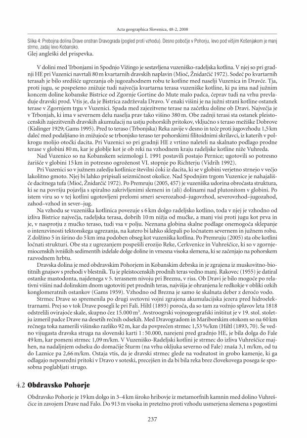
Slika 4: Prebojna dolina Drave onstran Dravograda (pogled proti vzhodu). Desno pobo~je v Pohorju, levo pod vi{jim Ko{enjakom je manjstrmo, zadaj levo Kobansko.Glej angle{ki del prispevka.
V dolini med Trbonjami in Spodnjo Vi`ingo je sestavljena vuzeni{ko-radeljska kotlina. V njej so pri grad-nji HE pri Vuzenici navrtali 80m kvartarnih dravskih naplavin (Mio~, @nidar~i~ 1972). Sode~ po kvartarnihterasah je bilo sredi{~e ugrezanja ob jugozahodnem robu te kotline med naselji Vuzenica in Drav~e. Tja,proti jugu, se pospe{eno zni`uje tudi najve~ja kvartarna terasa vuzeni{ke kotline, ki pa ima nad ju`nimkoncem doline kobanske Bistrice od Zgornje Gortine do Mute malo padca, ~eprav tudi na vrhu prevla-duje dravski prod. Vtis je, da je Bistrica zadr`evala Dravo. V enaki vi{ini je na ju`ni strani kotline ostanekterase v Zgornjem trgu v Vuzenici. Spada med zajezitvene terase na za~etku doline ob Dravi. Najve~ja jev Trbonjah, ki ima v severnem delu naselja prav tako vi{ino 380 m. Obe zadnji terasi sta ostanek pleisto-censkih zajezitvenih dravskih akumulacij na ustju pohorskih pritokov, vklju~no s teraso me`i{ke Dobrove(Kislinger 1929; Gams 1995). Pred to teraso (Trbonjska) Reka zavije v desno in te~e proti jugovzhodu 1,5kmdale~ med podalj{ano in zni`ujo~e se trbonjsko teraso ter pohorskimi filitoidnimi skrilavci, iz katerih v pol-krogu molijo oto~ki dacita. Pri Vuzenici so pri gradnji HE z vrtino naleteli na skalnato podlago prodneterase v globini 80 m, kar je globlje kot je ob reki na vzhodnem kraju radeljske kotline ni`e Vuhreda.
Nad Vuzenico so na Kobanskem seizmologi l. 1991 postavili postajo Pernice; ugotovili so potresno`ari{~e v globini 15 km in potresno ogro`enost VI. stopnje po Richterju (Vidrih 1992).
Pri Vuzenici so v ju`nem zaledju kotlinice {tevilni ~oki iz dacita, ki se v globini verjetno strnejo v ve~jolakolitno gmoto. Njej bi lahko pripisali seizmi~nost okolice. Nad Spodnjim trgom Vuzenice je nahajali{-~e dacitnega tufa (Mio~, @nidar~i~ 1972). Po Premruju (2005, 457) je vuzeni{ka udorina obro~asta struktura,ki se na povr{ju pojavlja s spiralno zakrivljenimi slemeni in (ali) dolinami nad plutonitom v globini. Poistem viru so v tej kotlini ugotovljeni prelomi smeri severozahod–jugovzhod, severovzhod–jugozahod,zahod–vzhod in sever–jug.
Na vzhodu se vuzeni{ka kotlinica povezuje s 6 km dolgo radeljsko kotlino, toda v njej je vzhodno odizliva Bistrice najve~ja, radeljska terasa, dobrih 10 m ni`ja od mu~ke, a manj visi proti jugu kot prva inje, v nasprotju z mu~ko teraso, tudi vsa v polju. Neznana globina skalne podlage onemogo~a sklepanjeo intenzvinosti tektonskega ugrezanja, na katero bi lahko sklepali po lo~natem severnem in ju`nem robu.Z dol`ino 5 in {irino do 5 km ima podoben obseg kot vuzeni{ka kotlina. Po Premruju (2005) sta obe kotlinilo~nati strukturi. Obe sta z ugrezanjem pospe{ili erozijo Reke, Cerkvenice in Vuhre{~ice, ki so v zgornje-miocenskih ivni{kih sedimentih izdelale dolge doline in vmesna visoka slemena, ki se za~enjajo na pohorskemrazvodnem hrbtu.
Dravska dolina je med obdravskim Pohorjem in Kobanskim debrska in je zgrajena iz muskovitno-bio-titnih gnajsov s prehodi v blestnik. Tu je pleistocenskih prodnih teras vedno manj. Rakovec (1955) je datiralostanke mastodonta, najdenega v 5. terasnem nivoju pri Breznu, v riss. Ob Dravi je bilo mogo~e po rela-tivni vi{ini nad dolinskim dnom ugotoviti pet prodnih teras, najvi{ja je ohranjena le redkokje v obliki ozkihkonglomeratnih ostankov (Gams 1959). Vzhodno od Brezna je samo {e skalnata deber z dero~o vodo.
Strmec Drave so spremenila po drugi svetovni vojni zgrajena akumulacijska jezera pred hidroelek-trarnami. Prej so v tok Drave posegli le pri Fali. Hiltl (1893) poro~a, da so tam za vo`njo splavov leta 1818odstrelili ovirajo~e skale, skupno ~ez 15.000 m3. Avstroogrski vojnogeografski in{titut je v 19. stol. stolet-ju izmeril padce Drave na desetih re~nih odsekih. Med Dravogradom in Mariborskim otokom so na 60 kmre~nega toka namerili vi{insko razliko 92 m, kar da povpre~en strmec 1,53 %/km (Hiltl (1893, 70). [e ved-no vijugasta dravska struga na slovenski karti 1 : 50.000, narejeni pred gradnjo HE, je bila dolga do Fale49 km, kar pomeni strmec 1,09 m/km. V Vuzeni{ko-Radeljski kotlini je strmec do izliva Vuhre{~ice maj-hen, na nadaljnjem odseku do doma~ije [turm (na vrhu okljuka severno od Fale) zna{a 3,1 m/km, od tudo Laznice pa 2,66 m/km. Ostaja vtis, da je dravski strmec glede na vodnatost in grobo kamenje, ki gaodlagajo neposredni pritoki v Dravo v soteski, precej{en in da bi bila reka brez ~lovekovega posega {e spo-sobna poglabljati strugo.
4.2 Obdravsko Pohorje
Obdravsko Pohorje je 19 km dolgo in 3–4 km {iroko hribovje iz metamorfnih kamnin med dolino Vuhre{-~ice in zavojem Drave nad Falo. Do 913 m visoka in prete`no proti vzhodu usmerjena slemena s pogostimi
Acta geographica Slovenica, 48-2, 2008
237

Ivan Gams, Geomorfologija Pohorja
slemenskimi nivoji na vrhu v n. v. med 800 in 900 m najbolj brazdajo doline potokov, ki pritekajo z ovr{-ja Pohorja.
Obdravsko Pohorje je ju`no krilo kobanske antiklinale. Slemena in doline na ju`nem kobanskem pobo~-ju se na drugi strani Drave praviloma ne nadaljujejo premo~rtno v Obdravsko Pohorje in levi dravski pritokiso precej {tevilnej{i. Med krajema Brezno in O`bolt se v Dravo izlivajo kobanski pritoki Rem{ni{ki, Brez-ni{ki, Poto~nikov, Javni{ki, Grgasov potok in ^rmenica. Njihove do 7 km dolge doline s strmimi pobo~jiso v srednjem in spodnjem delu globoke do sto in ve~ metrov. S povpre~nim razmikom en kilometer sonajbolj goste v Sloveniji, kar ka`e na njihovo mladost. Pri Podvelki se v lo~nati strukturi slemenski lokdvigne v Hlebovem vrhu na 913 m in nato v polkrogu zni`uje proti Dravi pri O`baltu.
Da se Obdravsko Pohorje dviguje brez ve~jih prekinitev, tako kot Pohorje, dokazuje odsotnost pobo~-nih teras. Epigenezo Dravske doline sta zagovarjala med drugimi `e Melik (1957) in Sölva (2005). Tuditrditev, da je stara Drava sprva nasipavala prod v Gra{ki kotlini ali v zahodnih Slovenskih goricah, je sta-ra (Winkler 1944, 145–168). Vsi navedeni, Mio~ in @nidar~i~ (1972) ter Melik (1957, 74–75) so bili mnenja,da je v naslednji fazi Drava tekla po ribni{ko-lovren{ko-selni{kem podolju, ne da bi pojasnili, kdaj in zakajse naj bi do 854 m dvignilo hribovje v pore~ju Velke in Plav`nice, ki te~eta proti vuzeni{ko-radeljski kot-lini. To hribovje je enako visoko kot v Obdravskem Pohorju.
Na Kobanskem zdaj ni ve~ sledov pre~ne dravske doline proti Gra{kemu ni`avju. Nasprotno, oblikanajdalj{e kobanske, proti jugozahodu teko~e reke ̂ rmenice govori celo za mlaj{o preto~itev k Dravi. Nje-na dolina pri izlivu v Dravo je {iroka 0,8 km, 3,5 km vi{e v Spodnji Kapli 2,5 km in v ivni{kih skladih narazvodju pred dr`avno mejo v kraju Gradi{~e na Kozjaku 6 km. Tam, na vrhu Kobanskega, je ^rmenicacelo preto~ila povirje dveh zahodnih dravskih pritokov, Grgasovega in O`baltskega. Preto~itev ^rmeni-ce je v skladu s trditvijo, da ima Drava ni`e Maribora v nasprotju z Muro ve~jo erozijsko mo~ kot Mura,saj ima dalj{e leve pritoke kot desne (Melik 1957).
Slika 5: Pogled s hriba sv. Antona proti Pohorju (to je v ozadju) zajema ju`ni del 6 km dolgega hribovskega ozemlja, kjer naj bi po mnenjunekaterih geomorfologov nekdaj tekla Drava in tok nadaljevala proti vzhodu.Glej angle{ki del prispevka.
4.3 Ribni{ko-lovren{ko-selni{ko podolje
Ribni{ko-lovren{ko-selni{ko podolje je geolo{ko iz zgornjemiocenskih konglomeratov, pe{~enjakov in lapo-rovcev. V podlagi jih sestavlja klasti~no gradivo re~nega nastanka, vi{e so re~no-jezerski in na vrhu braki~ni(Mio~ 1977). Povr{je podolja je pove~ini gri~evnato, v vi{inah med 400 in 700 m. Selni{ko podolje, ki jenadaljevanje lovren{kega, zavzema dno Dravske doline od Fale naprej do Maribora. Pod Falo sega holocen-ska naplavina do skalnatega dna v globini 100 m. Po [ercljevi pelodni analizi (cit. iz Mio~, @nidar~i~ 1978)je fluvioglacialni vr{aj pri Lovrencu na Pohorju iz srednjega würma. Med Lovrencem in Falo je v pore~-ju Lamprehtovega potoka lo~ena manj{a kotlinica z neravnim dnom, zapolnjena s pe{~eno glino, v katerije [ercelj ugotovil pelod iz zadnjega würmskega vi{ka (Mio~ 1977).
Na vzhodnem koncu lovren{kega podolja je v terciarnem gri~evju edinstveni primer vpliva recentnetektonike na re~no omre`je. 50 m nad Dravo pri Fali je v n. v. 420–450 m sleme, usmerjeno proti severu,z naseljem ^in`at na vrhu. Na stiku neogena z metamorfnimi sedimenti v Rutah je 5 km dolg ozek pasdacita v smeri zahod–vzhod. Gozdar falske gra{~ine Hiltl (1895, 75) navaja za Pohorje potresa v letih 1791in 1794. Reliefne oblike na vzhodnem pobo~ju slemena z vr{nim naseljem ^in`at niso v skladu s splo-{nim naklonom pobo~ja. Pod naseljem se na njem za~enjata dve dolini. V eno od njiju so od kmetije Re~nikvodoravno po pobo~ju in po vrhu slemena umetno speljali odvod iz Lamprehtovega potoka na nasprot-no, vzhodno pobo~je slemena. Po tej kmetiji doma~ini {e zdaj imenujejo ves vodni tok do izliva v Murkovpotok Re~nikov potok. S preto~itvijo so pove~ali vodno silo za zdaj `e dolgo propadle `age. Pred nedav-nim so del te vode s ^in`ata po ceveh speljali naravnost navzdol do nove lokalne elektri~ne centrale obDravi, kadar ta deluje. ^e bi tja tekel tudi Re~nikov potok, bi imel za polovico kraj{i tok kot zdaj, ko jeob transverzalnem toku dolg do izliva v Murkov potok okoli tri kilometre. Proti severu-severovzhodu usmer-jeni dve pobo~ni dolini se zdru`ita malo pred sedaj asfaltirano cesto Pu{~ava–Fala, kjer stoji gosti{~e Falskidvorec. Tam so pred leti graditelji pred asfaltiranjem ceste Pu{~ava–Ru{e ve~ metrov na debelo nasuli dolin-sko dno. Gru{~ so dobili z 10m globokim zni`anjem prevala v desnem dolinskem pobo~ju; s tem so odpravili
238
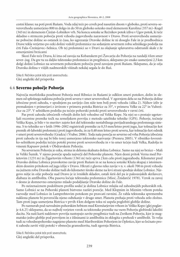
cestni klanec na poti proti Ru{am. Voda zdaj te~e po ceveh pod nasutim dnom v globoko, proti severu-se-verovzhodu usmerjeno 800 m dolgo in do 50 m globoko sotesko med slemenom Karolina (357 m)–Kogel(343m) in slemenom ̂ in`at–Lobnikov vrh. Na koncu soteske se Re~nikov potok izliva v Ugov potok, ki te~eskladno s strmcem pobo~ja proti vzhodu-jugovzhodu naravnost v Dravo. Proti severovzhodu usmerje-ne pobo~ne doline so ostanek iz ~asa, ko ugrezanje Dravske doline {e ni doseglo Fale in je predhodnicaDrave tekla verjetno po ozki dolini vzdol` prelomnice na sedanjem severnem robu selni{kega podolja na~rti Fala–^re{njevec–Selnica. Ob tej prelomnici so v Dravi za olaj{anje splavarstva odstranili skale z `eomenjenimi brzicami
Skozi Falo te~e Drava, ki ima od zavoja na Kobanskem pri @avcarju do Pohorja na razdalji 4 km smersever–jug. Da gre tu za dalj{o tektonsko prelomnico in pregibnico, sklepamo po enako usmerjeni 2,5 kmdolgi dolini Lobnice na severnem pohorskem pobo~ju pred zavojem proti Ru{am. Sklepamo, da je o`jaDravska dolina v vi{jih nadmorskih vi{inah nekdaj segala le do Ru{.
Slika 6: Re~nikov potok te~e proti severovzhodu.Glej angle{ki del prispevka
4.4 Severno pobo~je Pohorja
Najve~ja morfolo{ka posebnost Pohorja med Ribnico in Ru{ami je odklon smeri potokov, dolin in sle-men od splo{nega naklona pobo~ja proti severu v smer severovzhod. V zgornjem delu so na Pohorju dolineizbo~ene proti zahodu, v spodnjem pa zavijejo ~im ni`e tem bolj proti vzhodu (slika 2). Njihov izliv jepremaknjen v primerjavi z izvirom v primeru potoka Bistrice za 35°, v primeru Velke za 22° in Vuhre{-~ice za 23°. V selni{kem podolju pa te~ejo pohorski potoki proti severovzhodu v ravni ~rti.
Pas proti zahodu izbo~enih vrhnjih dolin le`i vzhodno od Velike Kope. Na njej so s postajo ugotav-ljali recentne premike to~k na zemeljskem povr{ju z metodo satelitske tehnike (GPS). Pohorje, to~nejeVelika Kopa, je bilo v to meritev zajeto kot del tektonsko nestabilnega perijadranskega prelomnega siste-ma. S to tehniko so v letih 1996–2002 registrirali premike za 0,53 mm/letno proti jugu, kar tolma~ijo kotpremik ob labotski prelomnici proti jugovzhodu, in za 0,48 mm letno proti severu, kar tolma~ijo kot odmikv smeri proti severovzhodu (Gradcu) (Vrabec 2006). Toda na{a pore~ja so severno od vrha Pohorja izbo~enaproti zahodu in tja naj bi bilo torej usmerjeno tektonsko narivanje (Premru 2005). V ribni{ko-lovren{-ko-selni{kem podolju te~ejo potoki premo proti severovzhodu in v to smer te~ejo tudi Velka, Radolja invmesni Kapusov potok v Obdravskem Pohorju.
Na severnem Pohorju je ozka, strma in deloma skalnata dolina Lobnice. Samo na njej so brzice – Maliin Veliki [umik. V njeno pore~je spada najve~ji del Pohorske planote. Njen desni pritok Verna med Per-{etovim (1231 m) in @igartovim vrhom (1361 m) te~e sprva 2 km celo proti jugozahodu. Kilometer predDravsko dolina Lobnica pravokotno zavije proti Ru{am in se na koncu soteske Klu`a skupaj z istoimen-skim desnim pritokom od juga izlije v Dravo. Hkrati z glavno reko zavije v n. v. okoli 700 m proti vzhoduna ju`nem robu Dravske doline tudi do kilometer {iroko sleme na levi strani spodnje doline Lobnice. Nje-govo ni`je in o`je pobo~je nad Dravo je iz ivni{kih skladov, ostali {ir{i del pa iz paleozojskih skrilavcev,diabaza in amfibolita. Oba pasova lo~uje tektonska prelomnica (Mio~, @nidar~i~ 1978). Vzrok za zavojv desno je domnevno omenjeno mlado podalj{anje Dravske doline do Fale.
Po neizena~enem podol`nem profilu sode~ je dolina Lobnice mlaj{a od zahodnej{ih pohorskih rek.Samo Lobnici se na Pohorski planoti bistveno raz{iri pore~je. Med Klopnim in Miznim vrhom potekarazvodje med Lobnico in Lamprehtovim potokom po pravcati ravnini. @e rahla tektonska spremembanaklona planote bi povzro~ila njeno odtekanje v drugo smer. Planota prehaja proti vzhodu zelo zlo`no.Tam proti jugu usmerjena Bistrica v prvih 4 km dolgem toku ni uspela poglobiti globlje doline.
Po razmerah pod razvodnim pohorskim hrbtom med Krem`arjevim vrhom in Veliko Kopo (glej poglav-je 4.6.2!) sklepamo, da so najbolj verjeten vzrok za tektonske premike na vsem Pohorju globinski lakolitidacita. Na na{i karti naklonov povr{ja nastopajo zavite pregibnice tudi na Zre{kem Pohorju, kjer je mag-matsko jedro globlje pod povr{jem in z `ilninami iz amfibolita in eklogita s prehodi v amfibolit. To veljatudi za vzhodnopohorsko nagnjeno planoto med Mariborskim Pohorjem in Oplotico, kjer so lo~nato pro-ti zahodu zaviti vi{ji potoki v obmo~ju granodiorita, tudi zgornja Bistrica.
Slika 6: Re~nikov potok te~e proti severozhodu.Glej angle{ki del prispevka.
Acta geographica Slovenica, 48-2, 2008
239

Ivan Gams, Geomorfologija Pohorja
4.5 Vzhodno in jugovzhodno Pohorje
Vzhodno od Per{etovega vrha (1242 m) se najvi{je pohorsko razvodno sleme vedno bolj odmika od skle-njenega granodioritnega vzhodnopohorskega ozemlja, {e zlasti potem, ko se sleme Ru{kega Pohorja usmeriproti vzhodu-severovzhodu, to je proti Mariboru. V trikotu @igartov vrh–Po{tela in @igartov vrh–Zgor-nja Polskava je pobo~je na {irokih vrhovih slemen zlo`no, prevladujejo nakloni 6–12 stopinj. Pobo~jadolin pa so bolj strma, 12–20°. Gri~evje v kraju ^reta ju`no od Polanskega potoka ima zna~ilno imeBrda.
Tamkaj{nji potoki ponikajo v prodna tla ravnega Dravskega polja, kjer je nekdaj bilo klasi~no obmo~-je izgonov. Ta zna~aj se izgublja, odkar so {tevilne izgone doma~ini zravnali. Bili so dokaz hitrej{e rastinaplavine kot zna{a tektonsko ugrezanje Dravskega polja. To ugrezanje polja je pospe{evalo poglabljanjedolin v zalednem robnem Pohorju, ki je zato bolj grapasto. Samo v tem delu Pohorja se vr{aji potokovgloboko zajedajo med gri~evnat svet, tako da je rob Pohorja iz metamorfih kamnin nazob~an.
Med Zgornjo Polskavo in spodnjim tokom Oplotnice spreminja metamorfni rob Pohorja {ir{i gri-~evnat rob, vmesne goste doline so o`je, gri~evnata slemena bolj poseljena, rob Pohorja pa manj izrazit,ker nekatera njegova slemena manj sklenjeno prehajajo v 20–35 m visoke neogene Podpohorske gorice(in te dalje na JV v Dravinjske gorice). Slednje v okolici Slovenske Bistrice gradi pliokvartarni pesek, pe{-~ena glina, glinast in pe{~eno glinast laporovec, glinasti prod in posamezni, do 40 cm dolgi prodniki izpohorskih kamnin (@nidar~i~, Mio~ 1989). Jugozahodneje prevladuje v goricah med prodi, peski in ilo-vicami kremen~eva primes, med Lo`nico in Zre~ami pa je v gri~evju med piokvartarnimi sedimentiprime{anih ve~ zgornjemiocenskih sedimentov izpod Karavank (Mio~, @nidar{i~ 1972). Na pomembendele` periglacialnega gru{~a s Pohorja v pliokvartarnih podgorskih naplavinah in na gru{~nato perigla-cialno odejo na zalednem Pohorju je opozoril [ifrer (1974). Na tem polkro`nem robu Pohorja je na na{ikarti naklonov vrisana pregibnica. Ta izraz je v slovensko geomorfologijo uvedel Habi~ (1984) in pome-ni v reliefu viden dalj{i, lahko tudi lokalno prekinjen zna~ilni prehod v druga~no strmino.
Tretji del Vzhodnopohorskega pobo~ja, ki je pore~je Bistrice nad slapom Bistri{ki [um, je najboljplanotast in najbolj zaslu`i ime nagnjena vzhodnopohorska planota. Prevladujejo nakloni 6–12°, kar jemanj kot zna{a posipni kot za gru{~. Izrazito ozko in dolgo pore~je Bistrice v povirju zavija proti seve-ru in tamkaj{nje njeno pore~je predstavlja prehod med pohorsko planoto in vzhodnopohorsko nagnjenoplanoto.
Ker je naklon 4–20 zna~ilen tudi za ple~ata slemena med razmeroma ozkimi dolinami doslej opisa-nega vzhodnopohorskega pobo~ju med Ho~ami in spodnjo, proti jugu usmerjeno dolino Oplotnice, gasmemo v celoti uvrstiti med nagnjeno vzhodnopohorsko planoto.
V pliokvartarju so v podno`ju hribovja erozija ve~jih rek Bistrica, Oplotnica in Dravinja in neotek-tonsko ugrezanje izdelali kotlinice. Taka je tudi konji{ka depresija (kotlina), ki je zapolnjena s kvartarnimiin pliokvartarnimi sedimenti, prinesenimi s Pohorja in tudi s Karavank (@nidar{i~, Mio~ 1989).
Odlaganje re~nega transporta v ugrezajo~ih se kotlinah je pospe{ilo erozijo in poglabljanje pohorskihrek spodnje Bistrice in celotne reke Oplotnice, dolina slednje namre~ predstavlja zahodno mejo vzhod-nopohorske nagnjene planote.
Med Ho~kim potokom in pore~jem Bistrice so doline na vzhodnopohorskem pobo~ju nad 350–450 mnadmorske vi{ine izbo~ene proti jugozahodu, domnevno kot posledica tektonskih premikov v to smer.Pozornost vzbuja nesimetri~no pore~je zgornje Polskave. Njeni dalj{i pritoki Velika Polskava, potok iz Fraj-hama, Mala Polskava in Brunik nad Loko pri Framu potekajo proti jugovzhodu, a so razmaknjeni za endo treh kilometrov, zbirni potok pa te~e v smeri vzhod-severovzhod. S tem je njeno zgornje re~no o`iljepodobno polomljenim vilam, ki imajo odlomljen ~etrti, desni rogelj – pritok Brunik. Ta se pred izlivom{e ogne prelomnici in osameli vzpetini z naseljem na vrhu – Gradi{~em; Polskavi se pridru`i ni`je po ovin-ku. Glavni tok Polskave med [martnom na Pohorju in Gradi{~em poteka domala pravokotno na smersplo{nega zni`evanja pobo~ja. Razlago za to nenavadnost re~nega o`ilja lahko i{~emo v zmi~nem prelomu.
V pore~ju zgornje Bistrice so nakloni povr{ja najmanj{i, 4–20°. Bistrica ima od vseh dalj{ih pohor-skih rek najkraj{e pritoke. Od slapa Bistri{ki [um, kjer se stika tr{i granodiorit z blestnikom, reka zavijeproti jugovzhodu ([u{ter{i~ in ostali 2005). Do 250 m globoka dolina Oplotnice poteka med Cezlakomin Roglo po robnem ozemlju iz granodiorita blizu stika z blestni{kim ozemljem; vzrok za tak{no usmer-jenost doline pa {e ni pojasnjen. ̂ e bi ta reka od izvira v ^rnih mlakah na severni strani Roglje tekla naravnostv smeri najve~jega strmca pohorskega pobo~ja, to je proti Zre~am, bi bil njen tok dolg ne 16 km, kot je
240

zdaj do naselja Oplotnica, temve~ 9 km. 250–300 m globoka dolina do Cezlaka, razen v povirju, z leve stra-ni ne dobiva ve~jih pritokov. Tri kilometre vzhodno od njene struge je v Velikem vrhu (1344 m) ohranjenostanek nekdanje krovnine iz blestnikov. Lahko bi ga uporabili za dokaz, da se je reka pri poglabljanjuv tr{o podlago ujela po preboju skozi blestni{ko odejo, ki je danes sklenjena 5 km severneje. Med kraje-ma Jurgovo in Cezlak je dolina izbo~ena proti zahodu, ni`e Cezlaka pa dno zavija proti JV in kon~no jugu.Sode~ po razlomljenih smereh poteka po dnu doline zmi~ni prelom.
Dolina spodnje Oplotnice in Oploti{nica s pritoki na Pohorju predstavljajo pahlja~asto pregibnico.Podobno odstopanje od splo{nega naklona pobo~ja je pri Dravinji: njen izvir je zra~no oddaljen od Vita-nja 6 km, njen tok proti vzhodu-jugovzhodu pa je dolg 15 km. Podobno je s sosednjo reko Hudinjo. Njenza~etni 3,7 km dolg tok ni`e Kraguli{~a (1454 m) te~e proti jugu-jugozahodu. Po izlivu pritoka z imenomPa{ka voda zavija 2,2 km proti jugovzhodu, potem pa se obrne proti jugozahodu in pod Vitanjem pri Gole-`evem gradu zaide n. v. okoli 450 m v globoko sotesko med Pa{kim Kozjakom in Stenico. Dolina Jesenicemed Lo{perkom in Vitanjem je polkro`ne oblike.
Razlago za po{evno po pobo~ju usmerjene zgornje doline ter za majhno pore~je Dravinje in Hudi-nje lahko i{~emo v razmeroma mladem predoru savinjskih pritokov Dravinje in Hudinje skozi dvigajo~ese Vzhodne Karavanke. Verjetno je intenzivna korozija povzro~ila, da savinjski pritok Tesnica ni`je nase-lja Beli potok nad naseljem Beli Potok v dnu globoke prebojne doline Socke v n. v. pribli`no 410 m medStenico in Konji{ko goro ne te~e po sklenjenem ozkem pasu iz prete`no nekarbonatnih zgornje miocen-skih sedimentov, temve~ tik zraven po le malo ni`jem pasu apnenca. Zato Tesnica svojega izvira pri Stranicahni podalj{ala globlje v Pohorje. Je skozi sotesko Socko nekdaj tekla predhodnica Savinje, ki v Celjski kot-lini v zadnji ledeni dobi ni zapustila izdatnej{ega würmskega proda? Po mnenju Mezeta (1963) je tedajtekla skozi Vzhodne Karavanke proti Dravskemu polju.
Prvotni odtok z ju`nega pohorskega pobo~ja proti jugu k Savinji je v kristalastem triasnem apnencuizvotlil nekaj sto metrov {iroko slepo dolino med krajema Spodnji in Zgornji Brezen. Njeno dno se nadDolí{kim podoljem za~enja malo nad terciarnimi ivni{kim skladi pri doma~iji Strme~nik v n. v. 740 m.Dno se po~asi dviguje in zavija proti jugozahodu pod Basali{~e. Tam je v kraju Zgornji Brezen dolina naj-globlja, do 200 m. Njen nastanek pripisujemo kontaktni koroziji pohorskega potoka, pritekajo~ega na vrhuivni{kih skladov, v katerih je Dolí{ko podolje, s karbonatno kamnino Pa{kega Kozjaka (Gams 1999, s. 458).V vi{ini te slepe doline je v Doli{kem podolju ostalo razvodje med Hudinjo in Pako na cestnem klancuz doma~im imenom Lo{perk (703 m). Vi{insko razliko (nad 700 m) med omenjeno slepo dolino in Lo{-perkom ter Pohorsko planoto lahko pripi{emo mlaj{emu tektonskemu dvigu Pohorja.
Ob pospe{eni re~ni eroziji po nastanku prebojne doline Hudinje pri Vitanju je nastala na dolinskihpobo~jih ni`e planj gosta mre`a obdobnih poto~kov, ki z gostimi dolinicami prepre~ujejo kmetijsko nase-litev in rabo, tako da so ostali pod gozdom. Podobno je v hribovitem pore~ju Dravinje.
Vzhodno od najvi{jega vrha Basali{~a (1272 m) se greben Pa{kega Kozjaka umika proti jugu, tako kottudi vsa Stenica, Konji{ka gora pa je v celoti za nekaj kilometrov odmaknjena proti jugu.
Slika 7: Zahodno Dolí{ko podolje, kjer se v spodnjem Dolí~u stikajo trije tipi reliefa: kopasti dolomitni gri~i (sredi) kot del Dolí{kega podolja,ju`no pohorsko pobo~je (skrajno levo) in koni~asti apneni{ki hribi (sredi) pod goro Pa{ki Kozjak (skrajno desno).Glej angle{ki del prispevka.
Triasni dolomiti sestavljajo severno od prebojne doline Pake v Hudi luknji hribe Doli{ke plo{~e, nakaterih so erozijski ostanki zgornjemiocenskih skladov. Na severnem koncu enega od njih je predrto ju`-no pobo~je kon~ne doline Mislinje. To izkori{~a cesta Velenje–Slovenj Gradec, ki v n. v. 600 m dose`e dnoMislinjske doline le 170 m dale~ od nekaj metrov ni`jega toka Mislinje. Predor je delo erozije pritoka Pake.^e bi to pobo~je pri cerkvi sv. Jedert predrla Mislinja, bi nedvomno nepovratno stekla proti 2,7 km odda-ljeni in 150 m ni`ji Paki v Hudi luknji.
Mlaj{o raz{iritev pore~ja Pake na ra~un Mislinje nakazuje jugovzhodno od naselja Mislinja kratka pobo~-na suha dolina v n. v. 720 m, ki poteka v triasnem dolomitu v n. v. 720 m ~ez doma~ijo Turjak protijugovzhodu.
V osamelem hribu Tisnik (785 m) so 2175 m dolga jama Huda luknja, v n. v. 575 m 91 m dolga jama[pehovska, v n. v. 670 m 252 m dolga jama Pilanca, na samem vrhu hriba pa kratka jama Klet; vse naj biizvotlila Paleopaka (Mihevc, Vrabec 2005). Ni pa {e izklju~ena mo`nosti neko~ vi{jega ponikanja odto-ka z miocenske zaplate zgornjemiocenskega konglomerata, pe{~enjaka in ilovic v slepi dolini Ponikve.
Acta geographica Slovenica, 48-2, 2008
241

Ivan Gams, Geomorfologija Pohorja
Doslej so omenjeni predvsem lokalni odkloni dolinske usmerjenosti od povpre~nega naklona {ir{e-ga pobo~ja.
Slika 8: Predrto levo pobo~je Mislinjske doline v Mislinji. Pod cerkvico ga je na ju`ni strani naselja do dna doline in vi{ine 600 m zni`alpritok savinjske Pake in olaj{al cestno povezavo med Podravjem in Posavjem.Glej angle{ki del prispevka.
4.6 Mislinjsko Pohorje
Mislinjski jarek, v katerem izvira Mislinja, z dol`ino 10 km in pod ̂ rnim vrhom z globino do 700 m mo~-no presega druge pohorske doline in razpolavlja Pohorje. Po Premruju (2005, 310) je vanj od zahoda segalZiljski prelom v raznih obdobjih in z raznimi imeni. Jarek je dobil izjemne razse`nosti tudi zaradi zmi~nihprelomov v dnu. V dnu je mogo~e lo~iti 5 ravnih odsekov razli~nih smeri, ki prehajajo od za~etne vzhod-no-severovzhodne v vzhodno–zahodno v kon~no smer severozahod–jugovzhod; v zadnji smeri pritekav razmeroma plitvem pobo~nem jarku pritok izpod Rogle, ki ima ime Mislinja. Glavni jarek se od soto~-ja z Mislinjo pri Pustotniku nadaljuje tri kilometre dalje proti severu v dolino pritoka Gla`uta. Njeni povirnicikle{~asto obdajata Skrivni vrh (1436 m) in nakazujeta obro~asto strukturo v sredi pohorskega gorovja.V 7 km dolgim kon~nem delu pred naseljem Mislinja je jarek {irok 5,5 do 8 km. Na jugu ga omejuje sle-me Volovica (1455 m) – Rogla (1517 m).
Mislinjski jarek, poglobljen prete`no v diaftoritu, obdaja okoli 1500 m visok polkro`ni razvodni hrbetz vrhovi ^rni vrh, 1543 m, Mali ^rni vrh, 1533 m, Jezerski (Ribni{ki) vrh, 1537 m, in po presledku v [i-klarici 2,5 km dolgo sleme z Ribni{kim jezerjem v vi{inah med okoli 1500 in 1540 m. Nedvomno mlaj{ijarek od goratega oboda s presenetljivo enakomerno vi{ino med 1500 in 1540 m je osnova sklepa, da jemislinjski pritok Gla`uta raz~lenil do 3 km {iroko planotico v vi{ini malo nad 1500 m, sama Mislinja ju`-neje od tod pa erozijsko zni`ala o`jo planotico v n. v. okoli 1450 m. Tako visoko sega ple~ato sleme na ju`nistrani pore~ja, ki je zahodno-jugozahodno od turisti~nega naselja na Rogli 4,5 km dolgo in kjer se vrsti-jo vrhovi Volovica, 1455 m, Turn, 1463 m, Kragulji{~e, 1454 m. Zahodno od Pohorske planote sega ~ez1400 m 2 m dolg hrbet Pesek (1423 m) – Lasina (1412 m), kar je podlaga mi{ljenju, da je tudi vzhodnejeod slemena Lovren{kih jezer prvotno obstajala planotica z okoli 1450 m vi{ine, a so jo zni`ali periglacial-ni procesi v bli`ini poledenelega obmo~ja in erozija rek, njeno vzhodno nadaljevanje na Vzhodnem Pohorjupa je tektonika dvignila v sedanje vi{ine med 1300 in okoli 1400 m.
[iroko in dolgo sleme pod ^rnim vrhom z imenom Planjave v naselju Mislinja lahko ozna~imo zaposebni tip reliefa – planje, ki je 10 km vzhodneje najlep{e razvit tudi na ju`ni strani pod slemenom Volo-vica (1455 m)–Rogla (1517 m)–Gradi{~e (1278 m). Zmerne strmine ohranja {e med za~etnimi potoki Pake,Hudinje in Dravinje (gl. karto nadmorskih vi{in!).
Razvodni hrbet Pohorja na ~rti Krem`arjev vrh–Kopa–Mali ^rni vrh poteka v dinarski smeri seve-rozahod–jugovzhod, kar je obenem smer labotske prelomnice. Je bli`je dolini Mislinje kot dolini Drave.
Zahodnej{i, do 200 m globoki in 5 km dolgi in do okoli 200 m globoki pohorski dolini Dov`anke inTuri~nice sledita splo{nemu strmcu pohorskega pobo~ja in te~eta pravokotno na smer zgornje Mislinj-ske doline. Pol do en kilometer oddaljeni reki sta redek primer vodnih tokov brez ve~jih pritokov (izjemaje pritok Dov`anke Jamovica, ki se zajeda v ^rni vrh in Planjave). Enakomerno proti jugu se zni`ajo~evmesno sleme Razborica dokazuje neprekinjeno dviganje gorovja in hkratno zni`evanje podgorja v Slo-venjgra{ki kotlini. Na skupnem kvartarnem prodnem vr{aju Dov`anka in Turi~nica nista uspeli znatnejepoglobiti skupne struge, kar je na zahodnem pohorskem obrobju redkost.
Labotski prelom na robu ozemlja iz pohorskih metamorfnih kamnin in obenem gorovja ni povsodpremo~rten. Rahli odkloni so pri krajih Bukovska vas, Dov`e, [entilj, Spodnji Doli~ in Vitanje, kar naka-zuje zmi~ni prelom (glej karto Mio~, @nidar~i~ 1972).
Slika 9: Zdru`en in erozijsko neraz~lenjen prodnati vr{aj rek Dol`anke in Turi~nice. V ozadju Velika Kopa. Sleme med dolinama, Razborica,je lep primer dokaj enakomerno in brez vodoravnih presledkov se dvigajo~ega se slemena proti Veliki Kopi (v ozadju).Glej angle{ki del prispevka.
242

4.6.1 Mislinjska dolina
Mislinjsko dolino sestavljajo {tirje geomorfolo{ko razli~ni deli. Devet kilometrov dolgo Spodnjo Mislinjskodolino lo~uje pri izlivu Me`e v Dravo in s tem od Dravske doline 400 m n. v. visoka kvartarna prodno-pe{-~ena terasa (me`i{ke) Dobrove, na kateri dravski prod in konglomerat ve~inoma pokrivata predrto skalnopodlago. Skozi vzhodno, edino odprto okno priteka k Dravi Me`a s pritokom Mislinjo. Pred Dobrovo seMislinjska dolina v Oti{kem vrhu trikotno raz{iri v majhno kotlinico z naseljema [entjan` in Oti{ki vrh.V njej je v [entjan`u pod hribom Selovec po dolgotrajnem odkopavanju prodno pe{~enega gramoza osta-lo le {e malo v jezeru nastale würmske fosilne delte Me`e, z nekdanjim vrhom malo pod 400 m.
Med [entjan`em in Slovenj Gradcem je 18 km dolga Spodnje mislinjska dolina dinarske smeri dokajenakomerno {iroka do enega kilometra. Do regulacije reke, najstarej{e na Mislinji, je bilo ravno aluvial-no dno Spodnje Mislinjske doline v ve~jem delu poplavno. Sode~ po tem je dolina tektonski jarek, ki seugreza med dvema vzporednima prelomnicama in stranskima pobo~jema. Pohorski potok Laku`nica jepo dolini odlagal naplavino, zato so doma~ini do nedavna vzdr`evali 1–2 m visok, zdaj odstranjen izgon.Samo v Pame~ah in Trobljah je potok Trobelj{~ica v ~asu obstoja würmskega zajezitvenega jezera nasulprodno teraso. Nadaljevanje proti jugovzhodu Mislinjski jarek zapira hrib Gradi{~e (517 m). Ju`no od nje-ga, na prehodu Spodnje Mislinjske doline v Slovenjgra{ko kotlino, te~e Mislinja v brzicah med strmim,v spodnjem delu mestoma skalnatim pobo~jem Rahtelovega hriba (677 m) in 100–150 m oddaljeno je`olegenske terase.
4.6.2 Slovenjegra{ka kotlina in Spodnja Mislinjska dolina
V Slovenjgra{ki kotlini sta dve akumulacijski terasni tvorbi, legenska in dobrovska, in dve dolini, Mislinj-ska in dolina Suhadolnice. 5 km dolga in do 350 m {iroka legenska terasa, edinstvena v podno`ju Pohorja,na severozahodnem robu kotline prestre`e pet pohorskih potokov. Pod razvodnim hrbtom med VelikoKopo in Krem`arjevim vrhom za~nejo slemena in vmesni potoki Porodnica, Reka, Barbarski potok in Brez-ni{ki potok (ta z ve~jim Krem`arjevim pritokom) v n. v. med 600 in 700 m ~im ni`e tem bolj zavijati izza~etne ju`ne v jugozahodno smer, nato na legenski terasi v skupnem potoku Barbari proti severozaho-du. Sleme pod Veliko Kopo za~enja pod Vrhnjakovim vrhom (936 m) v kraju Golavabuka podobno zavijatiin se zni`evati proti zahodu in kon~no severozahodu; zahodno od cerkve sv. Jurija postane skalnata je`alegenske terase, ta je zgrajena iz sprijetega peska in na vrhu proda. V Zgornjem Legnu sta na koncu legen-ske terase ob potoku Svarina dve prodnati terasi, vi{ja gozdnata in ni`ja ve~idel njivska, ki se edina sklenjenonadaljuje {e po Spodnjem Legnu in sega do Slovenj Gradca.
Slika 10: Slovenjgra{ka kotlina, pogled proti jugovzhodu (z n. v. 630 m). Levo pod (nevidnim) Pohorjem travni{ka terasa z naseljem Legen.Med terasnim koncem in pobo~jem Rahtelovega hriba se v o`ini ob Mislinji stikata zgornja in spodnja Mislinjska dolina. Zadaj gozdnatohribovje med Pa{kim Kozjakom (levo) in Ur{ljo goro.Glej angle{ki del prispevka.
Legenska terasa se proti jugovzhodu hitreje dviguje kot sosednja aluvialna ravnica ob Mislinji, zatoje terasa nad [martnim visoka `e 55 m. Tam so v je`i mestoma razkrite miocenske gline, v Slovenj Grad-cu pa se na vrhu je`e dvigata Ti~nica (459 m) in Borovnik (454 m), zgrajena iz filitoidnega skrilavca. Iznjega je tudi ju`ni rob sosednjega Rahtelovega hriba, ki ima tu kot pod vso Gmajno enako smer kot legen-ska je`a. Med Ti~nico in cerkvijo sv. Jurija sega na Legnu prodno pe{~ena naplavina ponekod ~ez vrh je`e,tako da se legenski metamorfni in dacitni prodniki posipajo proti 8–30 m ni`ji holocenski terasi ob Misli-nji. Vrhnja legenska terasa je do dana{nje vi{ine torej nastala isto~asno z enako visoko prodnope{~enoakumulacijo ob Mislinji, saj bi se sicer potok Barbara `e prej po bli`njici prelil ~ez je`o v Mislinjo. Vi{in-sko razliko med terasama moramo torej pripisati mlaj{emu tektonskemu ugrezanju v Mislinjski dolini(v o`jem smislu besede).
Severno od slemena Krem`arjev vrh–Velika Kopa ni podobnega enotnega zavijanja dolin kot na ju`nempobo~ju nad legensko teraso. V povirju Velke in Plav`nice se slemena krajevno le hru{kasto raz{irjajo (oko-li farnega sredi{~a v [emprimo`u in sv. Antonu).
Nad legensko teraso in pod slemenom Krem`arjev vrh–Velika Kopa so otoki in pasovi dacitnih `il-nin izbo~eni proti jugu, a jim doline ne sledijo in jih predirajo enako kot vmesne filitoidne skrilavce inpri tem ohranjajo v vi{jih legah smer proti jugovzhodu in v ni`jih proti zahodu. Omenjene razmere lahko
Acta geographica Slovenica, 48-2, 2008
243

Ivan Gams, Geomorfologija Pohorja
razlo`imo v lu~i meritev recentnega tektonskega dvigovanja s pomo~jo satelita (GMS) na Veliki Kopi. V le-tih 1996–2002 je ugotovilo odmikanje proti jugovzhodu s hitrostjo 0,53 mm letno (Vrabec, 2006). @ilninesmemo po vsej verjetnosti povezovati z nastankom proti jugovzhodu izbo~enih dolin.
Labotska prelomnica poteka na geolo{ki karti lista Slovenj Gradec po{evno ~ez kvartarno legenskoteraso (Mio~, @nidar~i~ 1972). ̂ e bi tudi tu sledila robu gorovja iz metamorfnih kamnin, bi morala zavi-ti okoli je`e legenske terase. Vzhodno od Golavabuke potekata ravni dolini Turi~nice in Dov`anke spetskladno s strmcem pobo~ja naravnost proti jugu.
Vzhodno od Velike Kope so pod pohorskim hrbtom doline vse do Lobnice izbo~ene proti zahodu,ni`e pa bolj premo~rtno usmerjene proti severovzhodu. Vzrok za izbo~enje lahko i{~emo v tektonskihpremikih proti zahodu, o katerih poro~a Premru (2005).
Slika 11: Legenska in dobrovska terasa.Glej angle{ki del prispevka.
Dva kilometra oddaljena od legenske terase je 6 km dolga in vzporedna pliokvartarna gozdnata tera-sa Dobrova. Dviga se do 30m nad dolinama Mislinje in Suhadolnice in njenim pritokom Jenino. Po geolo{kikarti 1 : 100.000 lista Slovenj Gradec je Dobrova iz pliokvartarne pe{~ene gline in glinastega proda, vmespa so redkej{i debeli prodniki iz pohorskih kamnin. Njen jugovzhodni del je do 2 km {irok in na vrhuraven. Na njem sta zaselek Mislinjska Dobrava in letali{~e. V nadaljevanju proti severozahodu pa se naddolino Suhadolnice na en kilometer zo`ena terasa Dobrova dviguje z zelo strmo je`o iz zgornjemiocen-skih pe{~enjakov, laporja in konglomerata. Na nasprotno, mislinjsko stran pa se zlagoma zni`uje v dnoMislinjske doline (v o`jem smislu besede).
Med legensko in dobrovsko teraso so pomembne razlike. V vsej 7 km dolg Dobrovi zna{a naklon ple-~atega vrha 1,07 m/km, v legenski terasi pa 12 m/km. Podobni pa sta v tem, da so v njihovi je`i razgaljenistarej{i sedimenti, filiti v legenski in zgornje miocenski v dobrovski.
Pohorski prodniki, ki so prime{ani v dobrovski terasi, so bili prvotno odlo`eni tudi na ni`jem jugo-zahodnem robnem pohorskem pobo~ju. Pred leti je bila na njem v kolovozu med kmetijama ^rnivnikin Mrzel v kraju Golavabuka pod pobo~nim koluvijem razkrita krpa tega proda kot dokaz najvi{je plei-stocenske prodne akumulacije Mislinje v vi{ini terase Dobrove (Gams 1976).
Med dobrovsko in legensko teraso je Mislinjska dolina (v o`jem smislu besede). V njej je pod legen-sko teraso aluvialna holocenska prodno-pe{~ena ravnica, kjer je Mislinja po zadnji svetovni vojni po opustitvimlinov in `ag in med prestavljanjem naplavine, nakopi~ene pred jezovi, ob povodnji uhajala prek kori-ta. Pri tem je v stari strugi odlagala debelej{i prod, v novi, vi{ji na holocenski ravnici pa je erodirala predvsempesek in ilovico in s tem izvajala selektivno erozijo (slika 11 + 12). Reka je z njo zni`ala za 2–3 m vi{joprodno teraso {mar{kega polja ni`e [martna, v kateri je Mislinja v ledeni dobi med peskom odlo`ila do38 cm dolge pohorske prodnike. Med krajema Mislinja in [martno se v strugi Mislinje dol`ina najdalj-{ih prodnikov zmanj{uje dosledno skladno z zmanj{evanjem re~nega strmca (Gams 1976).
Slika 12: Selektivna erozija Mislinje na holocenski ravnini: na levi sliki na holocenski ravnici ob povodnji po drugi svetovni vojni na novoerodirana struga.Glej angle{ki del prispevka.
Slika 13: Na desni stara struga, v kateri so vidni preostali debelej{i prodniki, potem ko je drobnej{e delce odnesla povodenj. Nova regula-cije je reko vrnila v staro strugo.Glej angle{ki del prispevka.
Mislinjo je na koncu Spodnje Mislinjske doline do n. v. okoli 395 m s prodom iz Celov{ke kotlinezajezila Drava s prodno teraso v (me`i{ki) Dobrovi (Kieslinger 1929; Gams 1995). Nastalo jezero je sega-lo do Slovenj Gradca. Tedanjo jezersko gladino je na koncu legenske terase z naplavino dvignil pritokBarbara na 409 m, to je do vi{ine osrednjega mesta v okolici cerkve. Na zahodni strani je srednjeve{komesto varovala strma je`a na koncu terase {mar{kega polja in nad dolino zajezene Suhadolnice. Teraso{mar{kega polja je naplavila ledenodobna Mislinja. Kot so razkrile novej{a razkopavanja v mestu, je Misli-nja tedaj na mestnem ozemlju na koncu terase pred jezerom odlagala drobnej{i prod in ve~ peska in siveilovice.
244

Slika 14: Spodnja Mislinjska dolina (slikana od jugovzhoda). Desno od nje severozahodno Pohorje in za njim Ko{enjak (1522 m). Raven potek,dokaj enakomerna {irina in nekdaj poplavno dno izpri~ujejo zna~aj ugrezajo~ega se tektonskega jarka. Dolina se nekoliko raz{iri na kon-cu pri Oti{kem vrhu. V vi{ini würmskega jezera (okoli 400 m n. v.) je (desno) pohorsko pobo~je zlo`nej{e in na terasi v Pame~ah bolj poseljeno.Glej angle{ki del prispevka.
Podobne razmere kot na Legnu so bile v dolini Suhadolnice. Ob vi{ku würma je tudi ta potok na izsto-pu iz ozke doline Suhi dol v vaseh Srednje in Spodnje Podgorje odlo`il prodni vr{aj – Podgorsko poljev n. v. med 425 in 440 m. Iz njega je reka izpirala drobnej{e frakcije in jih odlagala na robu jezera predmestom Slovenj Gradec. Od tega nasipa je po odva`anju gramoza ostala le ozka terasa v predmestju pod[tibuhom. Zdaj je tam po dolgotrajnem izkori{~anju gramoza ostal le {e kratek pomol, na katerem je tudinovo slovenjgra{ko pokopali{~e. Pe{~ena in drobna prodnata naplavina v njem je podobna tej v nekdajmnogo ve~ji delti Me`e na spodnjem koncu istega jezera pri [entjan`u, kjer je zaradi iz~rpanosti odko-pavanje gramoza prav tako prenehalo. Kon~na dolina Suhadolnice med krajem Radu{e in legensko terasoje rahlo izbo~ena proti zahodu in razmeroma {iroka. Da je nastala kot lo~nati tektonski jarek, sklepamotudi po domnevnima prelomnicama, vrisanima na geolo{ki karti lista Slovenj Gradec.
Slika 15: Pri Oti{kem vrhu je pleistocenska prodna dravska akumulacija zajezila pohorski potok iz Bavhovega grabna. Manj karbonatnih inve~ metamorfnih prodnikov in peskov v njej pomeni manj{o trdnost. Zato je po hudem nalivu l. 1986 nastali zemeljski plaz po{kodoval hi{iin zasul lastnico.Glej angle{ki del prispevka.
Na stiku {mar{ke prodne terase in terase Dobrove je povr{je rahlo zni`ano in tam vode s terase zbira potokHom{nica. V njenem zgornjem delu so nekdanji `elezni{ki nasip in sedanja glavna cesta prepre~ili njeneodtoke proti bli`nji Mislinji. Zdaj umetno podalj{ani potok ni`je zato {e pogosteje poplavlja (Gams 1992).
Razmeroma slabo poznavanje geologije Slovenjgra{ke kotline je izpopolnil Geolo{ki zavod Sloveni-je s 1000 m globoko, za ~rpanje toplice neuspe{no vrtino blizu opu{~ene mestne toplarne na severnemkoncu dobrovske terase. Ju`no od vrtine je na vrhu te terase edina ve~ja ravnica v n. v. 450 m, ki se strmodviga nad Curavo vasjo. S strmo je`o se naokoli zni`uje proti jugu, severozahodu in severu, prav tu je bilaomenjena vrtina. Po elaboratu Geolo{kega in{tituta (Poro~ilo 1990) je vrtina na terasi [tibuha razkrila(poenostavljeno):• 2–56 m: prod z glinastim vezivom; pliokvartar,• 57–208 m pe{~enjaki, plasti konglomeratov, laporji in meljevec; miocen,• 209–264: svetlosiv dolomit; anizij ali zgornji trias,• 265–378: temnosiv dolomit, glinasti skrilavec in tuf; paleozoik, spodnji trias,• 379–1000 m: metamorfni kompleks; paleozoik.
Tukaj je poskus, iz sestave izvrtine ~asovno razporediti faze geomorfolo{kega razvoja trikotne slovenj-gra{ke kotline. Triasni sedimenti, predvsem 169m debel temnosivi triasni dolomit, so narinjeni na paleozojskemetamorfne kamnine 400 m od severnega roba podkaravan{kih zgornjemiocenskih skladov, pod kateri-mi je v bli`njem Podgorju in v sosedstvu dokazano narivanje Karavank proti severu. Tako narivanjev podgorju Ur{lje gore je dokazalo tudi izkopavanje premoga v Le{ah.
151 m debeli zgornje miocenski skladi nakazujejo intenzivno ugrezanje Slovenjgra{ke kotline. V Do-brovi so razkriti samo v je`i terase ob dolini Suhadolnice in njenega pritoka Jenina, sicer pa je iz njih {irokpas v podolju pod Karavankami in pod Pohorjem do Slovenskih Konjic. V 5 km dolgem pasu so ostalitudi na vrhu severozahodnega Pohorja v pore~ju Reke. Potrjuje, da so bili ivni{ki skladi Kobanskega ~ezPohorje povezani z enako starimi pod Karavankami (Sölva 2005). Zahodno od Starega trga je v njih naj-ni`ji, sto metrov visok preval v gri~evju, ki povezuje kotlino z dolino Sel~nice. Tu ~ez je domnevno potekalre~ni odtoka iz kotline v ~asu, ko zgornje in spodnje Mislinjske doline {e ni povezala enotna reka. 54 mpliokvartarnih sedimentov v vrtini nakazuje nadaljevanje ugrezanja kotline.
4.7 Severozahodno Pohorje
Severozahodno Pohorje sedimentno pripada kobanski geolo{ki seriji in je litolo{ko najbolj pester del Pohor-ja. V vi{jih legah v pore~ju Trbonjske Reke zavzemajo ivni{ki skladi 5 km dolg otok, sicer pa so zastopanevse ostale pohorske kamnine. Relief je tudi na razvodju kopast, razgiban, brez premo~rtnega razvodja med
Acta geographica Slovenica, 48-2, 2008
245
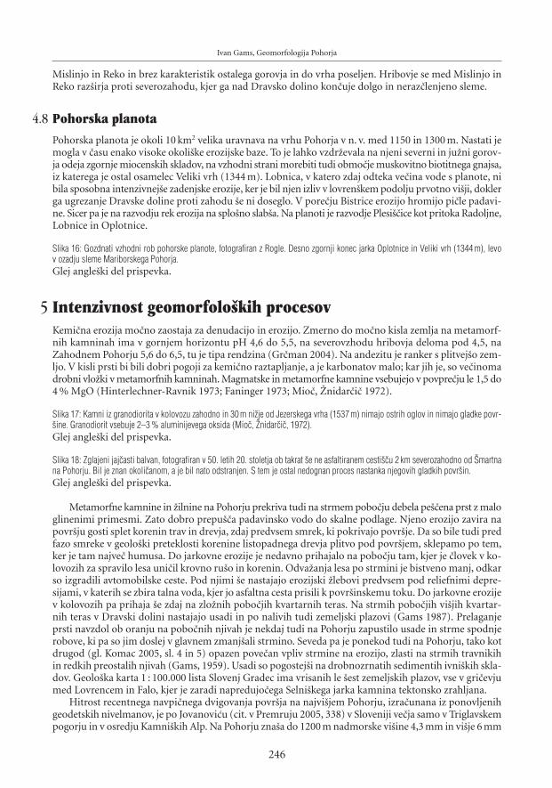
Ivan Gams, Geomorfologija Pohorja
Mislinjo in Reko in brez karakteristik ostalega gorovja in do vrha poseljen. Hribovje se med Mislinjo inReko raz{irja proti severozahodu, kjer ga nad Dravsko dolino kon~uje dolgo in neraz~lenjeno sleme.
4.8 Pohorska planota
Pohorska planota je okoli 10 km2 velika uravnava na vrhu Pohorja v n. v. med 1150 in 1300 m. Nastati jemogla v ~asu enako visoke okoli{ke erozijske baze. To je lahko vzdr`evala na njeni severni in ju`ni gorov-ja odeja zgornje miocenskih skladov, na vzhodni strani morebiti tudi obmo~je muskovitno biotitnega gnajsa,iz katerega je ostal osamelec Veliki vrh (1344 m). Lobnica, v katero zdaj odteka ve~ina vode s planote, nibila sposobna intenzivnej{e zadenjske erozije, ker je bil njen izliv v lovren{kem podolju prvotno vi{ji, doklerga ugrezanje Dravske doline proti zahodu {e ni doseglo. V pore~ju Bistrice erozijo hromijo pi~le padavi-ne. Sicer pa je na razvodju rek erozija na splo{no slab{a. Na planoti je razvodje Plesi{~ice kot pritoka Radoljne,Lobnice in Oplotnice.
Slika 16: Gozdnati vzhodni rob pohorske planote, fotografiran z Rogle. Desno zgornji konec jarka Oplotnice in Veliki vrh (1344 m), levov ozadju sleme Mariborskega Pohorja.Glej angle{ki del prispevka.
5 Intenzivnost geomorfolo{kih procesovKemi~na erozija mo~no zaostaja za denudacijo in erozijo. Zmerno do mo~no kisla zemlja na metamorf-nih kamninah ima v gornjem horizontu pH 4,6 do 5,5, na severovzhodu hribovja deloma pod 4,5, naZahodnem Pohorju 5,6 do 6,5, tu je tipa rendzina (Gr~man 2004). Na andezitu je ranker s plitvej{o zem-ljo. V kisli prsti bi bili dobri pogoji za kemi~no raztapljanje, a je karbonatov malo; kar jih je, so ve~inomadrobni vlo`ki v metamorfnih kamninah. Magmatske in metamorfne kamnine vsebujejo v povpre~ju le 1,5 do4 % MgO (Hinterlechner-Ravnik 1973; Faninger 1973; Mio~, @nidar~i~ 1972).
Slika 17: Kamni iz granodiorita v kolovozu zahodno in 30 m ni`je od Jezerskega vrha (1537 m) nimajo ostrih oglov in nimajo gladke povr-{ine. Granodiorit vsebuje 2–3 % aluminijevega oksida (Mio~, @nidar~i~, 1972).Glej angle{ki del prispevka.
Slika 18: Zglajeni jaj~asti balvan, fotografiran v 50. letih 20. stoletja ob takrat {e ne asfaltiranem cesti{~u 2 km severozahodno od [martnana Pohorju. Bil je znan okoli~anom, a je bil nato odstranjen. S tem je ostal nedognan proces nastanka njegovih gladkih povr{in.Glej angle{ki del prispevka.
Metamorfne kamnine in ̀ ilnine na Pohorju prekriva tudi na strmem pobo~ju debela pe{~ena prst z maloglinenimi primesmi. Zato dobro prepu{~a padavinsko vodo do skalne podlage. Njeno erozijo zavira napovr{ju gosti splet korenin trav in drevja, zdaj predvsem smrek, ki pokrivajo povr{je. Da so bile tudi predfazo smreke v geolo{ki preteklosti korenine listopadnega drevja plitvo pod povr{jem, sklepamo po tem,ker je tam najve~ humusa. Do jarkovne erozije je nedavno prihajalo na pobo~ju tam, kjer je ~lovek v ko-lovozih za spravilo lesa uni~il krovno ru{o in korenin. Odva`anja lesa po strmini je bistveno manj, odkarso izgradili avtomobilske ceste. Pod njimi {e nastajajo erozijski `lebovi predvsem pod reliefnimi depre-sijami, v katerih se zbira talna voda, kjer jo asfaltna cesta prisili k povr{inskemu toku. Do jarkovne erozijev kolovozih pa prihaja {e zdaj na zlo`nih pobo~jih kvartarnih teras. Na strmih pobo~jih vi{jih kvartar-nih teras v Dravski dolini nastajajo usadi in po nalivih tudi zemeljski plazovi (Gams 1987). Prelaganjeprsti navzdol ob oranju na pobo~nih njivah je nekdaj tudi na Pohorju zapustilo usade in strme spodnjerobove, ki pa so jim doslej v glavnem zmanj{ali strmino. Seveda pa je ponekod tudi na Pohorju, tako kotdrugod (gl. Komac 2005, sl. 4 in 5) opazen pove~an vpliv strmine na erozijo, zlasti na strmih travnikihin redkih preostalih njivah (Gams, 1959). Usadi so pogostej{i na drobnozrnatih sedimentih ivni{kih skla-dov. Geolo{ka karta 1 : 100.000 lista Slovenj Gradec ima vrisanih le {est zemeljskih plazov, vse v gri~evjumed Lovrencem in Falo, kjer je zaradi napredujo~ega Selni{kega jarka kamnina tektonsko zrahljana.
Hitrost recentnega navpi~nega dvigovanja povr{ja na najvi{jem Pohorju, izra~unana iz ponovljenihgeodetskih nivelmanov, je po Jovanovi}u (cit. v Premruju 2005, 338) v Sloveniji ve~ja samo v Triglavskempogorju in v osredju Kamni{kih Alp. Na Pohorju zna{a do 1200 m nadmorske vi{ine 4,3 mm in vi{je 6 mm
246

na leto. Iz teh podatkov lahko izra~unamo starost dviganja gorovja ob predpostavki, da je bilo dviganjeenakomerno ves ~as in se je za~elo na vi{ini 300 m n. v. Starost dviganja gorovja je po tem izra~unu oko-li 260.000 let, kar bi pomenilo za~etek v ri{ki ledeni dobi. Ra~unati pa je treba s po~asnej{im dvigom naza~etku in z neenako hitrostjo dviganja.
Doslej je na Pohorju meril odna{anje hribinske gmote, a brez suspenza v vodi in re~nega proda, leHidrometeorolo{ki zavod Slovenije v letih 1971 in 1972, in sicer na Ho~kem potoku in v reki Bistrici. Ugo-tovitvam je podalj{al veljavo tako, da je po okoli{kih padavinskih postajah ugotovil: povpre~no letnopogostnost tako suhih let kot je bilo leto 1971, in pogostost tako mokrih let, kot je bilo leto 1974, in tudi,kolik{no je povpre~no {tevilo dni s padavinami nad 40 mm in kolik{no je {tevilo dni z ve~ kot 20 mm pada-vin na dan (izmerjenimi v dobi 1961–1972). Kolbezen (1979) navaja, da je suspenza v merjenih potokihmalo in malo je v strugah tudi proda. V petih pore~jih zna{a na tej podlagi izra~unano povpre~no zni-`evanje povr{ja med 0,11 in 0, 21 mm na leto. V pore~ju Ho~kega potoka, ki je iz gnajsa in kjer so zadnjaleta v povezavi s turizmom na mariborskem Pohorju zgradili precej hi{, vrtov in drugega, zna{a izra~u-nano zni`evanje 0,27 mm, v pore~ju Bistrice le 0,02 mm/letno. Iz tega sledi, da bi se povr{je v milijon letihv povpre~ju zni`alo za 110 m, v pore~ju Ho~kega potoka za 270 m, v pore~ju Bistrice za 20 m. Pri tem niupo{tevan transport proda, ki je bil mo~no pospe{en v glacialnih dobah.
Po preglednici dosedanjih meritev v Sloveniji je izmerjena erozija Ho~kega potoka podobna najvi{jidotlej izmerjeni v Sloveniji in sicer za vinograd (v pore~ju Rokave). Navedena vsota za Bistrico pa je v vi-{ini povpre~ne erozijske izgube prsti na kmetijskih povr{inah Slovenije (Komac, Zorn 2005, 79). V ozkemvrhnjem pore~ju Bistrice je na vzhodnopohorski nagnjeni planoti v granodioritnem ozemlju povr{je boljgozdnato in za hribovje skladno z navedeno meritvijo nadpovpre~no zlo`no.
Zgoraj omenjeni izra~uni ne upo{tevajo transporta raztopljenih mineralov, ki ga je bilo v toplej{empliocenu ve~. Razen amfibolitov je na Pohorju rahlo topnih {e nekaj drugih mineralov (npr. eklogit – Mio~,@nidar~i~ 1972, 20). V povirju potokov Polskave so pasovi marmorja, katerega odlomljene skale se valijopo pobo~ju (@nidar~i~, Mio~ 1988). Korozijo na Vzhodnem Pohorju zmanj{uje malo padavin (1179 mm,[martno na P.), ki jih letno izhlapi 650–700 mm, tako da jih preostane le 529 do 579 mm za odtok. Odvseh delov Pohorja je tudi zato vzhodnopohorsko pobo~je najbolj ohranilo vi{ino in podobo tektonskopo{evno nagnjene planote
Erozija je nara{~ala skladno z dvigovanjem Pohorja. Ob dejstvu, da zdaj velik del erozije povsod odpa-de na izkr~ene, negozdnate in kmetijske povr{ine, je izra~unavanje erozijskega zni`evanja iz sedanjih razmervpra{ljivo za ugotavljanje zni`evanja reliefa za dobo pred naselitvijo ~loveka. Gostej{a naselitev se je naju`nem Pohorju pojavila v neolitu in eneolitu, to je 7000–3500 let pr. n. {t. ([ercelj 1996, 72).
Preglednica 1: Strmec izbranih vodnih tokov in padavine
vodni tok nadmorska vi{ina dol`ina strmec letne padavine obdobje vremenskavi{ina izvira izteka v km v m/km v mm postaja
Polskava 1000 294 14,5 55,6 1179 1961–1990 [martnoDevina 830 277 9,5 66,6 1043 1961–1980 Slovenska BistricaOplotnica 1420 379 15,0 70,0 1174 1961–1990 TinjeHudinja 1380 482 9,5 94,5 1517 1961–1990 RoglaPaka – Polenica 1280 600 3,6 188,0 1245 1961–1990 MislinjaMislinja – Mislinjski jarek 1440 605 19,5 69,1 1245–1527 Mislinja, Rogla,
podatki za 10 letTuri~nica 1325 560 6,0 126,7 1245 1931–1960 MislinjaLaku`nica 695 370 2,8 420,0 1334 1931–1990 Gradi{~eVuzeni{ka Reka 935 335 10,5 57,1 1132 1961–1990 [emprimo`Radoljna 1460 400 12,0 88,3 1627 1925–1940 Stara Gla`uta^rnava – Lobnica 1260 1100 3,6 44,4 1627 1925–1990 Stara Gla`utaLobnica* 1100 275 11,2 73,7 1627 1925–1990 Stara Gla`utaMislinja – Mislinja 600 332 21,0 12,8 1156 1961–1990 [martno pri Slovenj GradcuDrava med Dravogradom in Falo 337 288 (49) 1,09 1135 1961–1990 Dravograd
* Za~etni pritoki Lobnice na pohorski planoti imajo bistveno manj{i strmec kot reka na severnem pobo~ju. Strmec pritoka ^rnave do soto~ju z Majlandom je 36 metrov/km, toka Lobnice na strmem pobo~ju do izliva v Dravo pa 96 metrov. Dol`ina toka pomeni zra~no razdaljo med za~etkom ob~asnega ali trajnega toka in robom gorovja.
Acta geographica Slovenica, 48-2, 2008
247
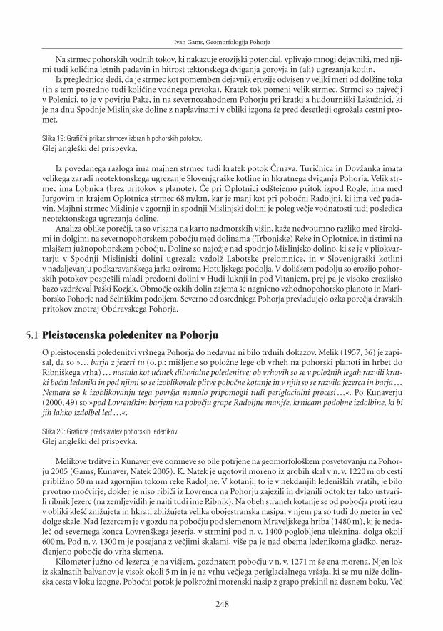
Ivan Gams, Geomorfologija Pohorja
Na strmec pohorskih vodnih tokov, ki nakazuje erozijski potencial, vplivajo mnogi dejavniki, med nji-mi tudi koli~ina letnih padavin in hitrost tektonskega dviganja gorovja in (ali) ugrezanja kotlin.
Iz preglednice sledi, da je strmec kot pomemben dejavnik erozije odvisen v veliki meri od dol`ine toka(in s tem posredno tudi koli~ine vodnega pretoka). Kratek tok pomeni velik strmec. Strmci so najve~jiv Polenici, to je v povirju Pake, in na severnozahodnem Pohorju pri kratki a hudourni{ki Laku`nici, kije na dnu Spodnje Mislinjske doline z naplavinami v obliki izgona {e pred desetletji ogro`ala cestni pro-met.
Slika 19: Grafi~ni prikaz strmcev izbranih pohorskih potokov.Glej angle{ki del prispevka.
Iz povedanega razloga ima majhen strmec tudi kratek potok ^rnava. Turi~nica in Dov`anka imatavelikega zaradi neotektonskega ugrezanje Slovenjgra{ke kotline in hkratnega dviganja Pohorja. Velik str-mec ima Lobnica (brez pritokov s planote). ^e pri Oplotnici od{tejemo pritok izpod Rogle, ima medJurgovim in krajem Oplotnica strmec 68 m/km, kar je manj kot pri pobo~ni Radoljni, ki ima ve~ pada-vin. Majhni strmec Mislinje v zgornji in spodnji Mislinjski dolini je poleg ve~je vodnatosti tudi posledicaneotektonskega ugrezanja doline.
Analiza oblike pore~ij, ta so vrisana na karto nadmorskih vi{in, ka`e nedvoumno razliko med {iroki-mi in dolgimi na severnopohorskem pobo~ju med dolinama (Trbonjske) Reke in Oplotnice, in tistimi namlaj{em ju`nopohorskem pobo~ju. Doline so najo`je nad spodnjo Mislinjsko dolino, ki se je v pliokvar-tarju v Spodnji Mislinjski dolini ugrezala vzdol` Labotske prelomnice, in v Slovenjgra{ki kotliniv nadaljevanju podkaravan{kega jarka oziroma Hotuljskega podolja. V doli{kem podolju so erozijo pohor-skih potokov pospe{ili mladi predorni dolini v Hudi luknji in pod Vitanjem, prej pa je visoko erozijskobazo vzdr`eval Pa{ki Kozjak. Obmo~je ozkih dolin zajema {e nagnjeno vzhodnopohorsko planoto in Mari-borsko Pohorje nad Selni{kim podoljem. Severno od osrednjega Pohorja prevladujejo ozka pore~ja dravskihpritokov znotraj Obdravskega Pohorja.
5.1 Pleistocenska poledenitev na Pohorju
O pleistocenski poledenitvi vr{nega Pohorja do nedavna ni bilo trdnih dokazov. Melik (1957, 36) je zapi-sal, da so »… barja z jezeri tu (o. p.: mi{ljene so polo`ne lege ob vrheh na pohorski planoti in hrbet doRibni{kega vrha) … nastala kot u~inek diluvialne poledenitve; ob vrhovih so se v polo`nih legah razvili krat-ki bo~ni ledeniki in pod njimi so se izoblikovale plitve pobo~ne kotanje in v njih so se razvila jezerca in barja …Nemara so k izoblikovanju tega povr{ja nemalo pripomogli tudi periglacialni procesi …«. Po Kunaverju(2000, 49) so »pod Lovren{kim barjem na pobo~ju grape Radoljne manj{e, krnicam podobne izdolbine, ki bijih lahko izdolbel led …«.
Slika 20: Grafi~na predstavitev pohorskih ledenikov.Glej angle{ki del prispevka.
Melikove trditve in Kunaverjeve domneve so bile potrjene na geomorfolo{kem posvetovanju na Pohor-ju 2005 (Gams, Kunaver, Natek 2005). K. Natek je ugotovil moreno iz grobih skal v n. v. 1220 m ob cestipribli`no 50 m nad zgornjim tokom reke Radoljne. V kotanji, to je v nekdanjih ledeni{kih vratih, je biloprvotno mo~virje, dokler je niso ribi~i iz Lovrenca na Pohorju zajezili in dvignili odtok ter tako ustvari-li ribnik Jezerc (na zemljevidih je najti tudi ime Ribnik). Na obeh straneh kotanje se od pobo~ja proti jezuv obliki kle{~ zni`ujeta in hkrati zbli`ujeta velika obojestranska nasipa, v njem pa so tudi do meter in ve~dolge skale. Nad Jezercem je v gozdu na pobo~ju pod slemenom Mraveljskega hriba (1480 m), ki je neda-le~ od severnega konca Lovren{kega jezerja, v strmini pod n. v. 1400 poglobljena uleknina, dolga okoli600 m. Pod n. v. 1300 m je posejana z ve~jimi skalami, vi{e pa je nad obema ledenikoma gladko, neraz-~lenjeno pobo~je do vrha slemena.
Kilometer ju`no od Jezerca je na vi{jem, gozdnatem pobo~ju v n. v. 1271 m {e ena morena. Njen lokiz skalnatih balvanov je visok okoli 5 m in je na vrhu ve~jega periglacialnega vr{aja, ki se mu ni`e dolin-ska cesta v loku izogne. Pobo~ni potok je polkro`ni morenski nasip z grapo prekinil na desnem boku. Ve~
248

metrov dolgi balvani, iz katerih je morena sestavljena, se vidno lo~ujejo od ni`jega drobnej{ega perigla-cialnega drobirja.
Odgovor na vpra{anje, zakaj se v okoli 70 m {iroki strmi uleknini na pobo~ju nad Jezercem nakopi-~ene velike skale niso odvalile v morensko kotanjo in jo zapolnile, nudi potek zadnje ledene dobe. Medwürmsko poledenitvijo je bilo na za~etku ve~ padavin in v gorah ve~ snega. Med leti 35.000 in 12.000 paje v Srednji Evropi zavladalo suho podnebje z 10 °C ni`jimi temperaturami in okoli 500 mm ni`jimi padavi-nami (Frenzel, Velicko 1992). Zato je na Pohorju ledeni{ko preoblikovanje povr{ja zamenjalo periglacialno.V tej dobi so lahko nastale nad Jezercem skale, ki so jim kmalu nato debla gozdnih dreves prepre~evala,da bi se skotalile. Nad ju`no moreno je uleknina plitvej{a in o`ja, prav za prav je bolj poglobljena in raz-{irjena dalj{a re~na dolina potoka, ki izvira vi{e na pobo~ju in te~e {e zdaj trajneje. Tu kot v {ir{i ju`nej{iokolici priteka v n. v. okoli 1400 m ve~ obdobnih potokov iz spodnjega roba pobo~ne odeje iz grobegaperiglacialne drobirja. Majhna poglobljenost uleknine nad ju`no moreno kot je nad Jezercem je tudi posle-dica kratkotrajnej{ega obstoja ledenika.
Slika 21: Malo pod n. v. 1300–1400 m se nad ju`no ledeni{ko uleknino za~enja periglacialna gru{~nata odeja, izpod katere tu in dalje protijugu izvirajo {tevilni potoki, ki so ni`e svoje struge ponekod poglobili do skalne podlage.Glej angle{ki del prispevka.
Nad globeljo obeh ledenikov je do 150 m visoko, zdaj travni{ko pobo~je, ki ga niso razbrazdali gla-cialni niti periglacialno procesi.
Vzrok, da je bilo poledenelo samo vzhodno pobo~je na severnem koncu 5 km dolgega, domala ena-ko visokega slemena severozahodno od Ostru{~ie (1498 m), so domnevno ve~je sne`ne padavine v bli`iniprevala [iklarica (1299 m).
Sestava periglacialnega drobirja na zahodnem pobo~ju slemena z vrhoma Lasina (1412 m) in Pesek(1423 m) je najlep{e razkrita v novem cesti{~u, ki se odcepi od kri`i{~a lokalne ceste, ob kateri je ni`e Jezerc,z glavno cesto iz Lovrenca. Makadamska cesta poteka po dolinskem pobo~ju desnega pritoka Radoljne.Skraja so v sve`e razkritem drobirju do en meter debeli kamni enake zaobljenosti, kot jo imajo tisti v bli`-nji strugi Radoljne. To se pravi, da je bila tedaj do te vi{ine zgornja dolina Radoljne zasuta s prodom, nanjpa je bila odlo`ena vedno debelej{a odeja periglacialnega peska, ki v vi{ji legi le`i neposredno na skalnipodlagi. Kjer je ju`neje na pobo~ju pe{~ena zemlja vla`na, je pesek ponekod krioturbatno naguban. Pro-ti jugu po dolini Radoljne dvigajo~a se cesta proti ko~i na Pesku kmalu razkriva vse kraj{e prodnike. MedMulejevim vrhom in Sedlom Komisije je obse`na, nekdaj v travnike spremenjena terasa iz peska, po kate-rem ima tudi ime Ko~a na Pesku.
Slika 22: Ju`neje in vi{je je nad novim kolovozom na zahodnem pobo~ju slemena Lasina (1412 m)–Pesek (1423 m) razkrita domnevno krio-turbatno zveri`ena pe{~ena preperina.Glej angle{ki del prispevka.
Da sta ledenika nastala samo na vzhodnem pobo~ju severnega konca slemena z Lovren{kim jezerjemna vrhu, je verjetno posledica lokalnih podnebnih razmer. Globoki dolini Radoljne in pritoka Plesi{~icaza nekaj kilometrov dale~ odmikata vr{no pobo~je Pohorja in zdru`ujeta pozimi prevladujo~e severovzhod-ne hladne zra~ne gmote iz Panonske kotline, kjer je bila v najhladnej{ih obdobjih pleistocena puhli~nastepa, proti jugozahodu, to je proti najni`jemu prevalu Komisiji, v smeri proti Sredozemski kotlini. Hudinalivi v pore~ju Radoljne {e zdaj povzro~ajo poplave in {kode ([eme 1994). Na Komisiji na severnem kon-cu Mislinjskega jarka ni pri{lo do nastanka ledenika zaradi prenizke vi{ine (1299m). [iklarica med Jezerskimvrhom (1537 m) in Planinko (1420 m) je najni`ji preval v 18 km dolgem hrbtu Pohorja med Malo Kopoin Roglo. Njej je bila najbli`ja vremenska postaja Stara Gla`uta, ki je namerila najve~ letnih padavin na Pohor-ju (1925–1940: 1627 mm), to je ve~ kot na vi{ji Rogli nad ju`nim robom pohorske planote (1517 mm).
Slabo zaobljene, do pol metra dolge balvane je Radoljna odlagala tudi na obmo~ju naselja Lovrencna Pohorju, ki je s poslopji in obdelovalnimi povr{inami vred na 2,5 km dolgem prodno pe{~enem vr{a-ju. @al v nekdanji gramoznici nad pritokom Slepnica niso ve~ razkriti v vsem pohorskem podgorju najdalj{iprodniki.
Acta geographica Slovenica, 48-2, 2008
249

Ivan Gams, Geomorfologija Pohorja
Slika 23: 2,5 km dolgi fluvioglacialni vr{aj in na njem nad terasno je`o razpotegnjeno naselje Lovrenc na Pohorju, slikan od SV. Nad odmak-njenim severnim pobo~jem v povirju Radovne se oblaki, kot je videti, za~enjajo najprej zbiratiGlej angle{ki del prispevka.
5.2 [oti{~a in jezera na Pohorju
Druga pohorska posebnost so {oti{~a na pohorski planoti. Obmo~je {oti{~ je med vrhovi Adamov vrh(1260) in Pesek (1427 m). Med mokrotnimi dolinicami so oble vzpetine, kjer je v cestnih golicah pod prst-jo lokalno razkrita periglacialna gru{~nata podlaga, dokaz, da so na planoti v pleistocenskih hladnih razdobjihvladali periglacialni geomorfolo{ki procesi.
V takih razmerah pobo~ni gru{~ lahko na prehodu na ravnico dvigne talno vodno gladino in pov-zro~i zamo~virjenost. Po drugi hipotezi naj bi bila zamo~virjenost posledica t. i. periglacialnih nivacijskihkotanj, ki so v sedanjosti pogoste v subarkti~ni klimi (Gams, Kunaver, Natek 2005). Toda te so ve~je odteh na Pohorski planoti. Na podrobnej{em zemljevidu lahko ugotovimo mo~virna {oti{~a v pasovih tudina ravnicah. Take primere najdemo zlasti na severozahodnem in vzhodnem robu planote. Ponekod jevzdol`ni profil poto~kov na mahovnati podlagi raz~lenjen na odseke med nekaj pedi visokimi jezovi iznakopi~enega mahu, pod katerimi so tolmuni. Najve~ja {oti{~a so v kotanjastih za~etkih stekajo~ih se poto~-kov. Tam jih je najbolj spremenil ~lovek. Mo~virje Tiho jezero ima na zemljevidih tudi ime Falski ribnik,kar ka`e na antropogeno zajezitev odtoka, tako kot so lovren{ki ribi~i pred stoletji zajezili mo~virje v `eomenjeni morenski kotanji Jezerc. Z zemeljskim nasipom so zajezili tudi mo~virje v ^rno jezero, da sodobili ve~ vode za splavljenje lesa po ri`i v dolini Lobnice na severnem pobo~ju gore (Gams, 1962). Splo-{na zamo~virjenost in s tem pojav {oti{~ na planoti nara{~a v smeri proti severozahodu, to je proti Klopnemuvrhu, to je v smeri nara{~anja koli~ine padavin.
Slika 24: V zamo~virjeni kotanji z imenom Radovina sta na pohorski planoti podrti smreki v {otni podlagi razkrili ostanke prej{njega drevesa.Kljub zavetni leti med okoli{kim gozdom vetrolomi tu na mo~virju o~itno nimajo te`kega dela.Glej angle{ki del prispevka.
Toplej{e pliocensko in holocensko borealno podnebje z listavci za {oto najbr`e nista bili ugodni, kerlistavci porabijo ve~ vode kot sedanji iglavci. Nedognan je vpliv ~loveka na spremembo gozda. O~itno seje zamo~virjenost pove~ala po sedanji prevladi iglavcev, {e zlasti po poseku gozda in po pa{i in po prvihpo`igih gozda, ki so jih povzro~ile strele ali pastirji. Nekdaj so Pohorci gozd na vrhovih po`igali za pa{o.Zaradi oddaljenosti vr{ne planote od dolinskih prometnih poti se lesa ni spla~alo podirati in voziti v podgorjevse do konca 19. stoletja. V 18. in 19. stoletju je ceneni les po vrhu gorovja za izdelavo oglja pritegnil fu`ine(v Mislinji in Lovrencu) in na severnem pobo~ju zlasti mlaj{e gla`ute. Malo pod Pohorsko planoto je delo-valo {est gla`ut, ki so rabile ogromno oglja. Na planoti so na golosekih zapustile zatravljena in zamo~virjenazemlji{~a. Tam in v drugih redkih okoli{kih gozdnih sestojih so pasli `ivino zlasti kmetje z Vitanjskega inZre{kega Pohorja. V fevdalni dobi in pozneje je bila Pohorska planota v lasti Falske gra{~ine, ki je dala naprimer v letu 1886 v najem ~ez 600 hektarjev zemlji{~ za pa{o 678 goveda. Ko je gra{~ina hotela pa{o poz-neje prepre~iti, saj je pove~evala zamo~virjenost, so se kmetje sklicevali na staro pravico (Hiltl 1993). Pravdamed njimi in sedanjo gozdno upravo {e vedno ni povsem kon~ana. Po vrhovih slemen na obeh straneh^rnega vrha (1543 m), Jezerskega vrha (1537 m) in vzhodno od [iklarice gozd {e ni zarasel gorskih trav-nikov, ker so na njih do nedavna {e pasli kmetje iz lovren{ke okolice. Na zemljevidih sta na vrhu slemenavzhodno od [iklarice vpisani imeni Planinka in ^rna mlaka, v slednji so napajali `ivino. Pove~ano zna-nje o {oti{~ih na pohorski planoti lahko pri~akujemo od bodo~ih modernih starostnih datacij {ote.
Pohorska posebnost so tudi Lovren{ko in Ribni{ko jezerje, obojno na vrhu barja. Na obeh so izved-li palinolo{ke raziskave. Na Lovren{kih jezerih je Budnar (1958) pod 240 cm debelo {oto ugotovila 60 cmdebel sloj peska in da je barje za~elo nastajati v holocenski zgodnji topli ali borealni dobi ozioma dobileske pred pribli`o 6000 leti. Z metodo radioaktivnih delcev je bila sedimentom pod povr{jem v globini14 cm v novej{em ~asu pripisana starost sto let glede na enakomerno rast vrhnje {ote (Brancelj, 1999).Bolj temeljite pelodne raziskave so prinesle naslednji razvoji razvoj po plasteh: –260–240 cm: leska, smre-ka in jelka, –240–220 cm: bukev, jelka, smreka, –220–150 cm: bukev, jelka, smreka, –150–130 cm: smreka,jelka, manj bukve, 130–60 cm: {otno blato, –60–0 cm: {otno barja, jezerska usedlina, nara{~a pelod smre-ke. Za~etek usedlin je bil predvidoma v atlantski fazi pred 7000–8000 leti (Culiberg, 1986). Ista avtorica
250

je objavila pelodno analizo tudi za Ribni{ko jezero: globina 300–290 cm: {ota s tonalitnim drobirjem, smre-ka in preko 50 % leske, 290–255 cm: leskova faza, jel{a, 255–200 cm: nara{~a jelka in zlasti bukev, gaberin pri 245 cm trave, starost 4080 ± 130 let, 200–100 cm: porast smreke in jelke, bukev, 100–50 cm: okrep-ljeni smreka in jelka, 50–0 cm: porast borovca.
Po teh meritvah je Lovren{ko jezerje staro okoli 3720 in Ribni{ko barje okoli 4080 let. Upad dele`abukve in jelke je pripisan vplivu ~loveka. Skupna ugotovitev: obojno barje ni nasledek ledene dobe, sajse akumulaciji za~enjata v atlantiku (7000–8000 let) ali kasneje (Culiberg, 1986). Na Pohorju so buko-vo-jelovi gozdovi prevladovali {e pred 7000 leti in smreka naj bi prevladala {ele v novej{em ~asu. Lokalnivplivi ~loveka na pohorski gozd so zaznavni od neolita naprej (Culiberg, M., A. [ercelj, 2000). Ugotovi-tev, da je {ota za~ela nastajati v holocenski zgodnji topli ali borealni dobi, je presenetljiva, saj je pri vi{jitemperaturi ve~ja evapotranspiracija rastlinstva, kar pomeni manj talne vlage. Toda vrtine so razkrile v pod-lagi ve~ ~rnkastih humoznih plasti, domnevno nastalih v jezerih pred okoli 3720 leti na Lovren{kem inv Ribni{ko barje okoli 4080 leti Upad dele`a bukve in jelke je pripisan vplivu ~loveka. Obojno barje torejni nasledek ledene dobe, saj se za~enjata v atlantiku (7000–8000 let) ali kasneje (Culiberg, 1986).
Lovren{ko in Ribni{ko jezerje nimata povsem enake lege. Prvo je na severnem koncu oblega sleme-na Rogla–Planinka v vi{inah malo nad 1500 m. Pesek v podlagi bi brez gozdne ali travne zarasti, kot jebilo v ~asu poledenitve, odpihnil veter. Do okoli 40 cm globoke kotanje Lovren{kih in Ribni{kih jezer sona samem razvodnem hrbtu, kjer je podtalni vodni dotok iz {otne okolice mo`en iz vseh strani. Zaraditake lege jezera poleti ne presu{ijo. Na ravnici je tudi najve~je, Ribni{ko jezero, a je, v razliko s [entlo-vren{kim jezerjem, na okoli 150 m {iroki planotici vzhodno od Jezerskega (Ribni{kega) vrha (1537 m),tako da je lahko na ju`ni strani med ru{evjem {e nekaj manj{ih vodnih »oken« (Gams 1962). Na vrhu sle-mena Rogla (1517 m) – Planinka zamo~virjenost nara{~a v smeri nara{~anja koli~ine padavin, to je protiseveru. Nad [iklarico je zamo~virjeno proti vzhodu se dvigajo~e travni{ko sleme z imenom Planinka, kjerje na zemljevidih ozna~ena ^rna mlaka.
6 O posebnosti raziskovanja geomorfologije v gorovju pohorskega tipa.
6.1 Slemena in doline kot indikatorji geomorfolo{kega razvoja
Podol`ni prerezi slemen med sosednima dolinama so bili narejeni za presojo, v koliko {e odra`ajo izho-di{~ne povr{ine, v katere je erozija poglobila doline. Na neskalnatih tleh se padavinska voda sprva ne odtekapovr{insko, temve~ pod povr{jem skozi preperino in tako vrh slemena zni`ujejo le pedolo{ki procesi. Odna-{anje kamninske gmote se za~enja ni`je na pobo~ju, kjer so izviri ob~asnih in trajnih vodnih tokov in seuveljavi globinska erozija.
Slika 25: V zgornjem Legnu je v dolinskem dnu, ki poteka vzdol` zmi~nega preloma, kamnina tektonsko zdrobljena in neporaslo pobo~jenestabilno.Glej angle{ki del prispevka.
Vrhovi slemen iz metamorfnih kamnin potekajo precej bolj ravno kot tisti iz ivni{kih skladov medRibnico in Vuzeni{ko kotlino, ker so iz petrografsko me{anega gradiva (glej podol`ne prereze slemen).V spodnji preglednici so upo{tevani le vzor~ni primeri za geomorfolo{ke enote.
Preglednica 2: Dol`ine in strmec izbranih pohorskih slemen, zna~ilnih za gorovje.
pohorska regija za~etek slemena konec slemena dol`ina strmec(nadmorska vi{ina v m) (nadmorska vi{ina v m) (km) (m/km)
severozahodno Pohorje Krem`arjev vrh 1164 Drav~e 380 12,6 62,2Lovren{ko Pohorje Klopni vrh 1340 Lovrenc 436 8,0 113,0Vzhodno Pohorje Per{etov vrh 1242 Zg. Bistrica 242 14,1 71,4Vitanjsko Pohorje Kraguli{~e 1454 Vitanje 460 10,0 99,4Zgornjemislinjsko Pohorje Velika Kopa 1543 Dov`e 575 7,2 134,4Spodnjemislinjsko Pohorje Golarjev vrh 834 [entjan` 358 3,8 125,3
Acta geographica Slovenica, 48-2, 2008
251
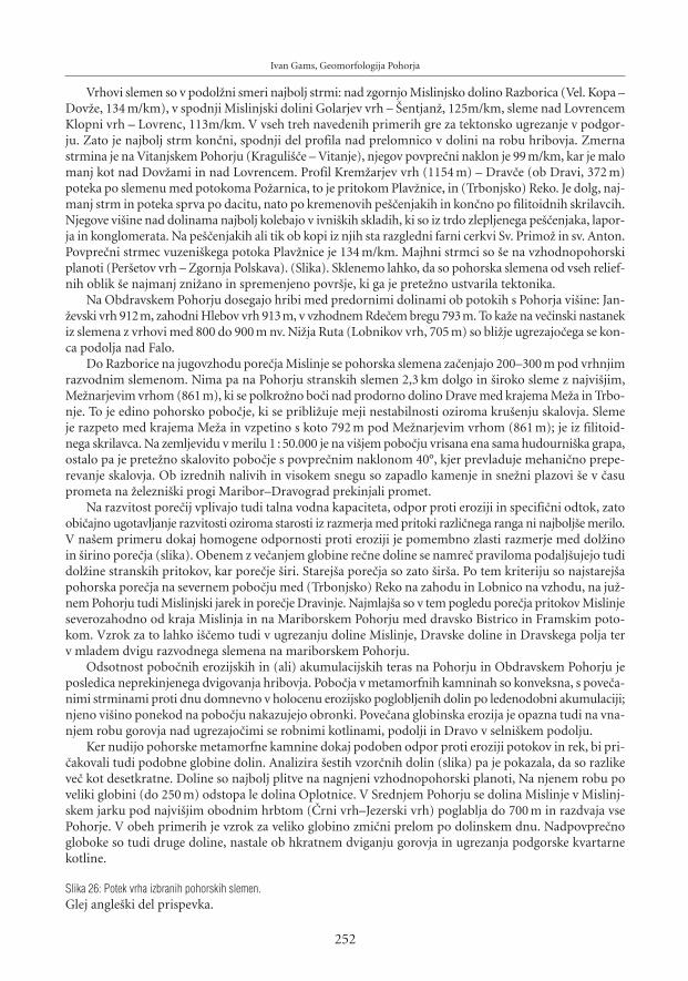
Ivan Gams, Geomorfologija Pohorja
Vrhovi slemen so v podol`ni smeri najbolj strmi: nad zgornjo Mislinjsko dolino Razborica (Vel. Kopa –Dov`e, 134 m/km), v spodnji Mislinjski dolini Golarjev vrh – [entjan`, 125m/km, sleme nad LovrencemKlopni vrh – Lovrenc, 113m/km. V vseh treh navedenih primerih gre za tektonsko ugrezanje v podgor-ju. Zato je najbolj strm kon~ni, spodnji del profila nad prelomnico v dolini na robu hribovja. Zmernastrmina je na Vitanjskem Pohorju (Kraguli{~e – Vitanje), njegov povpre~ni naklon je 99 m/km, kar je malomanj kot nad Dov`ami in nad Lovrencem. Profil Krem`arjev vrh (1154 m) – Drav~e (ob Dravi, 372 m)poteka po slemenu med potokoma Po`arnica, to je pritokom Plav`nice, in (Trbonjsko) Reko. Je dolg, naj-manj strm in poteka sprva po dacitu, nato po kremenovih pe{~enjakih in kon~no po filitoidnih skrilavcih.Njegove vi{ine nad dolinama najbolj kolebajo v ivni{kih skladih, ki so iz trdo zlepljenega pe{~enjaka, lapor-ja in konglomerata. Na pe{~enjakih ali tik ob kopi iz njih sta razgledni farni cerkvi Sv. Primo` in sv. Anton.Povpre~ni strmec vuzeni{kega potoka Plav`nice je 134 m/km. Majhni strmci so {e na vzhodnopohorskiplanoti (Per{etov vrh – Zgornja Polskava). (Slika). Sklenemo lahko, da so pohorska slemena od vseh relief-nih oblik {e najmanj zni`ano in spremenjeno povr{je, ki ga je prete`no ustvarila tektonika.
Na Obdravskem Pohorju dosegajo hribi med predornimi dolinami ob potokih s Pohorja vi{ine: Jan-`evski vrh 912m, zahodni Hlebov vrh 913m, v vzhodnem Rde~em bregu 793m. To ka`e na ve~inski nastanekiz slemena z vrhovi med 800 do 900 m nv. Ni`ja Ruta (Lobnikov vrh, 705 m) so bli`je ugrezajo~ega se kon-ca podolja nad Falo.
Do Razborice na jugovzhodu pore~ja Mislinje se pohorska slemena za~enjajo 200–300 m pod vrhnjimrazvodnim slemenom. Nima pa na Pohorju stranskih slemen 2,3 km dolgo in {iroko sleme z najvi{jim,Me`narjevim vrhom (861 m), ki se polkro`no bo~i nad prodorno dolino Drave med krajema Me`a in Trbo-nje. To je edino pohorsko pobo~je, ki se pribli`uje meji nestabilnosti oziroma kru{enju skalovja. Slemeje razpeto med krajema Me`a in vzpetino s koto 792 m pod Me`narjevim vrhom (861 m); je iz filitoid-nega skrilavca. Na zemljevidu v merilu 1 : 50.000 je na vi{jem pobo~ju vrisana ena sama hudourni{ka grapa,ostalo pa je prete`no skalovito pobo~je s povpre~nim naklonom 40°, kjer prevladuje mehani~no prepe-revanje skalovja. Ob izrednih nalivih in visokem snegu so zapadlo kamenje in sne`ni plazovi {e v ~asuprometa na `elezni{ki progi Maribor–Dravograd prekinjali promet.
Na razvitost pore~ij vplivajo tudi talna vodna kapaciteta, odpor proti eroziji in specifi~ni odtok, zatoobi~ajno ugotavljanje razvitosti oziroma starosti iz razmerja med pritoki razli~nega ranga ni najbolj{e merilo.V na{em primeru dokaj homogene odpornosti proti eroziji je pomembno zlasti razmerje med dol`inoin {irino pore~ja (slika). Obenem z ve~anjem globine re~ne doline se namre~ praviloma podalj{ujejo tudidol`ine stranskih pritokov, kar pore~je {iri. Starej{a pore~ja so zato {ir{a. Po tem kriteriju so najstarej{apohorska pore~ja na severnem pobo~ju med (Trbonjsko) Reko na zahodu in Lobnico na vzhodu, na ju`-nem Pohorju tudi Mislinjski jarek in pore~je Dravinje. Najmlaj{a so v tem pogledu pore~ja pritokov Mislinjeseverozahodno od kraja Mislinja in na Mariborskem Pohorju med dravsko Bistrico in Framskim poto-kom. Vzrok za to lahko i{~emo tudi v ugrezanju doline Mislinje, Dravske doline in Dravskega polja terv mladem dvigu razvodnega slemena na mariborskem Pohorju.
Odsotnost pobo~nih erozijskih in (ali) akumulacijskih teras na Pohorju in Obdravskem Pohorju jeposledica neprekinjenega dvigovanja hribovja. Pobo~ja v metamorfnih kamninah so konveksna, s pove~a-nimi strminami proti dnu domnevno v holocenu erozijsko poglobljenih dolin po ledenodobni akumulaciji;njeno vi{ino ponekod na pobo~ju nakazujejo obronki. Pove~ana globinska erozija je opazna tudi na vna-njem robu gorovja nad ugrezajo~imi se robnimi kotlinami, podolji in Dravo v selni{kem podolju.
Ker nudijo pohorske metamorfne kamnine dokaj podoben odpor proti eroziji potokov in rek, bi pri-~akovali tudi podobne globine dolin. Analizira {estih vzor~nih dolin (slika) pa je pokazala, da so razlikeve~ kot desetkratne. Doline so najbolj plitve na nagnjeni vzhodnopohorski planoti, Na njenem robu poveliki globini (do 250 m) odstopa le dolina Oplotnice. V Srednjem Pohorju se dolina Mislinje v Mislinj-skem jarku pod najvi{jim obodnim hrbtom (^rni vrh–Jezerski vrh) poglablja do 700 m in razdvaja vsePohorje. V obeh primerih je vzrok za veliko globino zmi~ni prelom po dolinskem dnu. Nadpovpre~nogloboke so tudi druge doline, nastale ob hkratnem dviganju gorovja in ugrezanja podgorske kvartarnekotline.
Slika 26: Potek vrha izbranih pohorskih slemen.Glej angle{ki del prispevka.
252
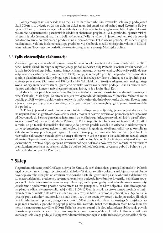
Pohorje v o`jem smislu besede se na meji z ju`nim robom ribni{ko-lovren{ko-selni{kega podolja nadokoli 700 m n. v. dviguje ob 24 km dolgi in dokaj ravni ~rti smeri vzhod–zahod med Zgornjim Radva-njem in Ribnico, oziroma to~neje: dolino Vuhre{~ice v Hudem Kotu, torej v glavnem ob tamkaj{nji tektonskiprelomnici na ju`nem robu pasu ivni{kih skladov in obenem ob pregibnici. Na jugozahodni, zgornje mislinj-ski strani je taka ~rta manj izrazita in bolj raz~lenjena. Dalje na ju`nem in jugovzhodnem robu je gorovjebolj drobno fluvialno raz~lenjeno predvsem na ni`jem obrobju, kot je vi{e na pobo~ju. Po mo~ni in gostiraz~lenjenosti v doline in slemena izstopa predvsem vi{je hribovje med Krem`arjevim vrhom in Mislinj-skim jarkom. To je verjetno posledica tektonskega ugrezanja zgornje Mislinjske doline.
6.2 Vpliv ekstenzijske ekshumacije
V so~asno ugrezajo~em se ribni{ko-lovren{ko-selni{kem podolju so v tektonskih ugrezninah ostali do 500mdebeli ivni{ki skladi. Razlago za ugrezanje tega podolja, so~asen dvig Pohorja (v o`jem smislu besede), ki{e traja in Obdravskega Pohorja, nudi koncepcija nastanka gorovja z ekstenzijo, ob kateri je pri{lo do raz-kritja oziroma ekshumacije (Summerfield 1991). Po njej se zemeljsko povr{je nad predorom magme skozispodnjo plast litosferske skorje dviguje, pod hladnej{o in redkej{o, v desno odmikajo~o se spodnjo plast-jo skorje pa se ugreza (Summerfield 1991, slika 4.8). Tako lahko s to teorijo razlagamo nastanek gorategasvoda Pohorja in na severni strani ugreznjeno ribni{ko-lovren{ko-selni{ko podolje. To se na zahodu za~e-nja pod zahodnim koncem najvi{jega pohorskega hrbta, to je v kraju Hudi Kot.
Slednja trditev pa dr`i samo, ~e lego Hudega Kota dolo~imo kot pravokotno na dinarsko usmerjenihrbet ̂ rni vrh – Mala Kopa. To ~rto nakazujeta dve vzporedni dolini pritokov Vuhre{~ice. Vzhodni konecpodolja pri Fali je v istem poldnevniku kot je vi{e na Pohorju vzhodni rob pohorske planote. Tako ̀ e samalega obeh enot potrjuje povezavo med najvi{e dvignjenim gorovjem in najbolj ugreznjenimi ivni{kimi skla-di v podolju.
Na Pohorju je med Krem`arjevim vrhom in Veliko Kopo na povr{je dvignjenega najve~ dacita v ob-liki naj{ir{ih ̀ ilnin in gostih oto~kov. Sicer se dacit v otokih in pasovih severno od pohorskega hrbta pojavljaod Dravograda do Pekrske gorce in na ju`ni strani do Mislinjskega jarka, po razvodnem hrbtu pa od Vrhov-skega vrha (642 m) na severozahodnem Pohorju do Velike kope. Ker te ̀ ilnine niso metamorfirale okoli{kihkamnin, so po teoriji ekstenzijske ekshumacije do povr{ja predrle zaradi nizkotla~no in nizkotempera-turno spremenjene gostote nekaterih mineralov. Blestnik in gnajs sta okoli granodioritnega ozemlja naVzhodnem Pohorju posebno gosto »prestreljena« z ozkimi pegmatitnimi in aplitnimi ̀ ilami (v dolini Lob-nice tudi cizlakita), ponekod dolgimi do enega kilometra in ve~ in z gostoto do ve~ ̀ ilnin na razdalji enegakilometra. Te prav tako niso metamorfirale okoli{kih sedimentov. Najbolj {iroke ̀ ilnine so zdaj med Krem`ar-jevim vrhom in Veliko Kopo, kjer je na severnem pobo~ju dokazana povezava med recentnim tektonskimpremikanjem povr{ja in izbo~enjem dolin. [e bolj so doline izbo~ene na severnem pobo~ju Pohorja v po-dolju vzhodno od potoka Plav`nice.
7 SklepV zgornjem miocenu je od Gra{kega ni`avja do Karavank prek dana{njega gorovja Kobansko in Pohorjasegal peneplen na vrhu zgornjemiocenskih skladov. Ti skladi so bili v dolgem razdobju na ve~ini obrav-navanega ozemlja erozijsko odstranjeni, v tektonsko nastalih ugrezninah pa so se ohranili z debelino ve~sto metrov, sklenjeno predvsem v severnokaravan{kem podgorju in v ribni{ko-lovren{ko-selni{kem podo-lju, v otoku tudi na severozahodnem Pohorju. Dana{nje, s sedanjo orografijo neskladno hidrografsko omre`jeje razlo`eno s podedovano prvotno re~no mre`o na tem peneplenu. Do 6 km dolga in 3–4 km {iroka pohor-ska planota, edina na vsem ozemlju, zdaj v vi{ini 1150–1330 m, je nastala na otoku iz metamorfnih kamnin,razkritem sredi ivni{kih skladov v vi{ini okoli{ke erozijske baze na razvodju pohorski rek. Njeno nada-ljevanje proti zahodu v nadmorskih vi{inah okoli 1430 m so pozneje v pore~ju Radoljne razkrojili mlaj{iperiglacialni in re~ni procesi, tistega v n. v. okoli 1500 m znotraj dana{njega zgornjega Mislinjskega jar-ka pa re~na erozija. V podobnih pogojih je nastal tudi razvodni hrbet med Roglo in Malo Kopo, ki na ve~mestih neznatno presega vi{ino 1500 m. Relief na ostalem ozemlju je plod tektonskega oblikovanja povr{jain zni`evanja zaradi re~ne erozije, vidno pospe{ene zaradi ugrezajo~ih se okoli{kih kotlin in ribni{ko-lo-vren{kega-selni{kega podolja. Na jugovzhodnem vi{jem pobo~ju so najmanj raz~lenjene zna~ilne planje.
Acta geographica Slovenica, 48-2, 2008
253

Ivan Gams, Geomorfologija Pohorja
Slika 27: Planja na vi{jem jugovzhodnem pohorskem pobo~ju v kraju Skómarje (zaselek s cerkvijo). Na levo navzgor se vrstijo najvi{je samotnekmetije pod gozdnatim Ov~arjevim vrhom. Med obdelanim povr{jem je gozd ostal samo v plitvih, komaj opaznih ozkih dolinicah.Glej angle{ki del prispevka.
Reka Drava je ob tektonskem dviganju Kobanskega epigenetsko nasedla na ju`nem robu kobanskeantiklinale in izdelala dana{njo dravsko deber. Dviganje Pohorja, ki {e traja, in so~asno tektonsko ugre-zanje do 500 m debelih zgornjemiocenskih (ivni{kih) skladov v ribni{ko-lovren{ko-selni{kem podolju inv severnem podgorju Karavank je razlo`eno s koncepcijo ekstenzijske ekshumacije (Summerfield 1991).
Slika 28: Mehanizem ekstenzijske eskhumacije, pri kateri nastanejo najprej razpoke v spodnjem delu litosfere, ki potem potone v astenos-fero, nazadnje pa pride do dviga zemeljske skorje, ki ga spremlja nadome{~anje s toplej{im in manj gostim podlitosferskim delom pla{~a(po Summerfield 1991, 91).Glej angle{ki del prispevka.
Pomembno je dejstvo, da je ribni{ko-lovren{ko podolje ugreznjeno samo severno od najvi{jega pohor-skega hrbta (upo{tevajo~ tudi rob pohorske planote. Zahodni rob ribni{kega podolja v kraju Hudi Kotje pravokotno na dinarsko potekajo~i hrbet Mala Kopa – ^rni vrh). Na Pohorju koncepcijo ekstenzijskeekshumacije podpirajo goste `ilnine dacita, eklogita, amfibolita in, osamljeno, cezlakita, ki niso dodat-no metamorfirale okoli{kih kamnin. S Pohorja se raztekajo~e reke so izdelale najgloblje doline vzdol` zmi~nihprelomov. Zaradi tektonskega pritiska so na severnem pohorskem pobo~ju doline sredi izbo~ene protizahodu, severneje, v ribni{ko-lovren{kem podolju pa usmerjene proti severovzhodu. Zavijanje slemen inpotokov od jugovzhoda proti jugozahodu nad legensko teraso pod pohorskim grebenom med Krem`ar-jevim vrhom in Veliko Kopo je domnevno povezano z recentnimi tektonskimi premiki s hitrostjo 0,53 mmletno proti jugovzhodu, izmerjenimi z metodo RMS v letih 1996–2002 na Veliki Kopi (Vrabec 2006). V geolo-giji zelo znana premo~rtna labotska prelomnica na je`i legenske terase izjemoma »odre`e« kos pohorskegafilitoidnega skrilavca. Zato in ker zavijajo pohorski potoki nad je`o proti zahodu in kon~no proti seve-rozahodu, je po reliefnih razmerah sklepati, da je v tem delu Pohorja bilo prvotno povirje (spodnje) Mislinje.
Najdalj{i, 10 km dolg in do 700 m globok Mislinjski jarek s koncem na prevalu [iklarica (1299 m) raz-polavlja gorovje. V njem pa, nepri~akovano, domala ni ̀ ilnin. Zato, ker je lakolit pod njim razklan? V ~asunajhladnej{ega oddelka würmskega glaciala so prek [iklarice pihajo~i hladni in snegonosni severovzhod-ni vetrovi, usmerjeni proti Sredozemlju, zaradi dviganja povzro~ili nastanek dveh, do en kilometer dolgihpobo~nih ledenikov v zgornji dolini reke Radoljne.
Ponovljena meritev nivelmanov je za ovr{je Pohorja nad 1200 m n. v. ugotovila tektonsko dviganje6 mm letno. Na pliokvartarno starost ka`e tudi izra~un na osnovi dveletnih meritev re~nega transporta(razen suspenza in proda) na vzhodnopohorskih potokih in odsotnost erozijskih in akumulacijskih pobo~-nih teras. Zlo`ni pohorski relief ni posledica velike starosti, temve~ hitrej{ega mehani~nega razkrajanjaprete`no zrnatih kamnin v vodoprepustni pesek, pokrit z gostimi koreninami trav in smreke, kar zavirapovr{insko re~no erozijo. Odtod prevlada zmernih strmin (12–30°).
Od uporabljenih geomorfolo{kih metod se je za uspe{no izkazala morfometri~na analiza pore~ij inglobine dolin. Ozka pore~ja so na severnem pobo~ju Mariborskega Pohorja in nad ugrezajo~o se Slovenj-gra{ko kotlino, v kateri so navrtali 54 m pliokvartarnih sedimentov; {iroka in dolga so na severni straniPohorja zaradi epigenetsko nastale Dravske doline med Dravogradom in Falo. Najgloblje pohorske doli-ne so vzdol` zmi~nih prelomov.
Globina Mohorovi~i~eve diskontinuitete je znana samo pod Pernicami severno od vuzeni{ke kotli-ne, zna{a 15 km. ̂ eprav dviganje Pohorja {e traja, je potresnost {ibka, domnevno zaradi manj kompaktnezemeljske skorje.
Na Vitanjskem Pohorju se pobo~je v vi{jem delu pore~ij Hudinje in deloma Dravinje zni`uje protijugu, potoki pa te~ejo proti jugovzhodu, ker so savinjski pritoki {ele v mlaj{i dobi prebili karavan{ki Pa{-ki Kozjak. Starej{i in vi{ji odtok je zapustil sled v slepi dolini v Pa{kem Kozjaku z naseljem Zgornji Brezen.
8 LiteraturaGlej angle{ki del prispevka.
254


![[Challenge:Future] Annual Wine Festival @Maribor - Pohorje](https://img.dokumen.tips/doc/110x75/589dd8ed1a28ab77148b4bff/challengefuture-annual-wine-festival-maribor-pohorje.jpg)


