Embed Size (px)
Citation preview
© WJEC CBAC Ltd.
GCSE MARKING SCHEME
GEOGRAPHY SPECIFICATION B SUMMER 2013
© WJEC CBAC Ltd.
INTRODUCTION The marking schemes which follow were those used by WJEC for the Summer 2013 examination in GCSE GEOGRAPHY SPECIFICATION B. They were finalised after detailed discussion at examiners' conferences by all the examiners involved in the assessment. The conferences were held shortly after the papers were taken so that reference could be made to the full range of candidates' responses, with photocopied scripts forming the basis of discussion. The aim of the conferences was to ensure that the marking schemes were interpreted and applied in the same way by all examiners. It is hoped that this information will be of assistance to centres but it is recognised at the same time that, without the benefit of participation in the examiners' conferences, teachers may have different views on certain matters of detail or interpretation. WJEC regrets that it cannot enter into any discussion or correspondence about these marking schemes. Page Unit 1 - Foundation Tier 1 Unit 1 - Higher Tier 10 Unit 2 - Section A Foundation Tier 20 Unit 2 - Section A Higher Tier 23 Unit 2 - Section B Foundation Tier 26 Unit 2 - Section B Higher Tier 33
1 © WJEC CBAC Ltd.
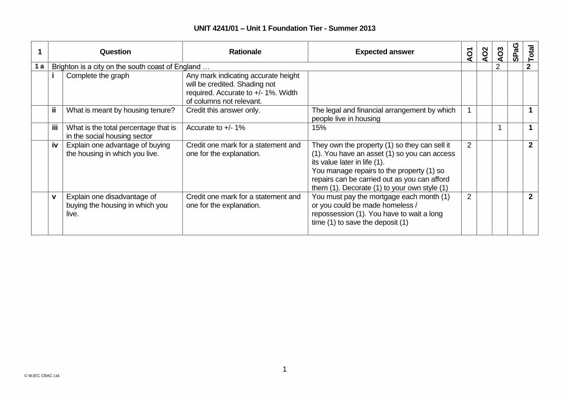
UNIT 4241/01 – Unit 1 Foundation Tier - Summer 2013
1 Question Rationale Expected answer
AO
1
AO
2
AO
3
SP
aG
To
tal
1 a Brighton is a city on the south coast of England … 2 2
i Complete the graph Any mark indicating accurate height will be credited. Shading not required. Accurate to +/- 1%. Width of columns not relevant.
ii What is meant by housing tenure? Credit this answer only. The legal and financial arrangement by which people live in housing
1 1
iii What is the total percentage that is in the social housing sector
Accurate to +/- 1% 15% 1 1
iv Explain one advantage of buying the housing in which you live.
Credit one mark for a statement and one for the explanation.
They own the property (1) so they can sell it (1). You have an asset (1) so you can access its value later in life (1). You manage repairs to the property (1) so repairs can be carried out as you can afford them (1). Decorate (1) to your own style (1)
2 2
v Explain one disadvantage of buying the housing in which you live.
Credit one mark for a statement and one for the explanation.
You must pay the mortgage each month (1) or you could be made homeless / repossession (1). You have to wait a long time (1) to save the deposit (1)
2 2
2 © WJEC CBAC Ltd.
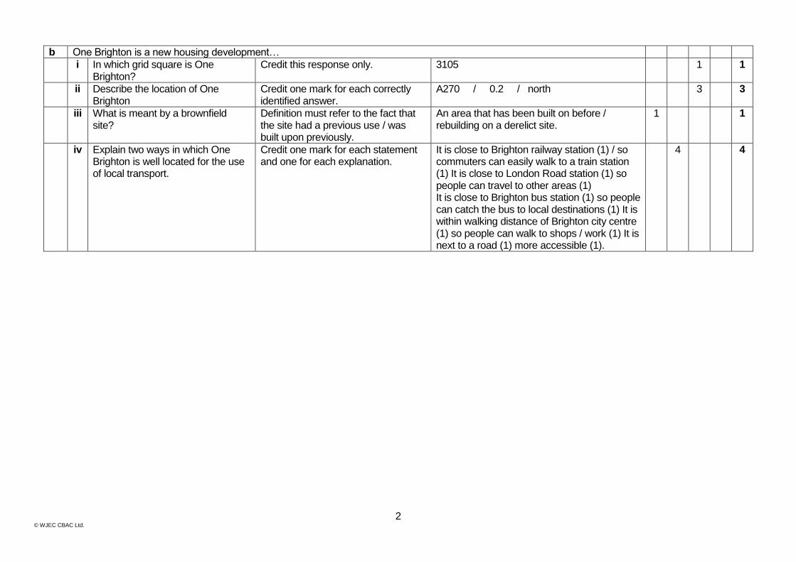
b One Brighton is a new housing development…
i In which grid square is One Brighton?
Credit this response only. 3105 1 1
ii Describe the location of One Brighton
Credit one mark for each correctly identified answer.
A270 / 0.2 / north 3 3
iii What is meant by a brownfield site?
Definition must refer to the fact that the site had a previous use / was built upon previously.
An area that has been built on before / rebuilding on a derelict site.
1 1
iv Explain two ways in which One Brighton is well located for the use of local transport.
Credit one mark for each statement and one for each explanation.
It is close to Brighton railway station (1) / so commuters can easily walk to a train station (1) It is close to London Road station (1) so people can travel to other areas (1) It is close to Brighton bus station (1) so people can catch the bus to local destinations (1) It is within walking distance of Brighton city centre (1) so people can walk to shops / work (1) It is next to a road (1) more accessible (1).
4 4
3 © WJEC CBAC Ltd.
Question Rationale Expected answer
AO
1
AO
2
AO
3
SP
aG
To
tal
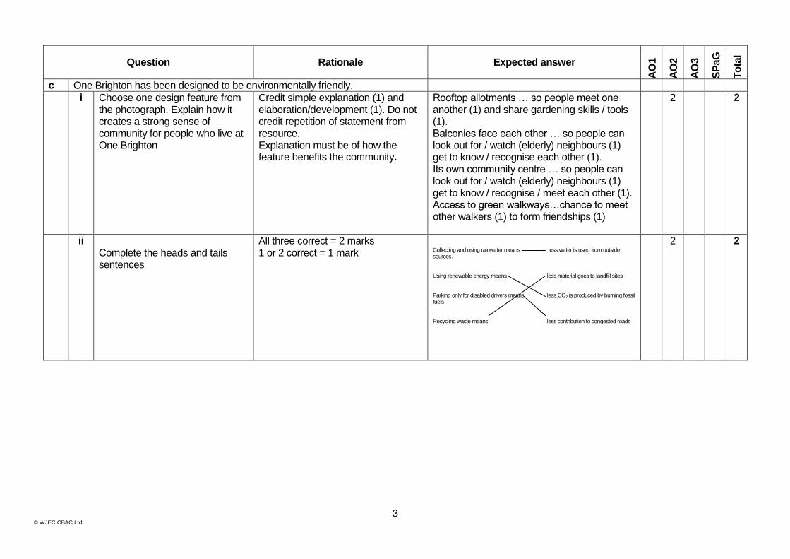
c One Brighton has been designed to be environmentally friendly.
i Choose one design feature from the photograph. Explain how it creates a strong sense of community for people who live at One Brighton
Credit simple explanation (1) and elaboration/development (1). Do not credit repetition of statement from resource. Explanation must be of how the feature benefits the community.
Rooftop allotments … so people meet one another (1) and share gardening skills / tools (1). Balconies face each other … so people can look out for / watch (elderly) neighbours (1) get to know / recognise each other (1). Its own community centre … so people can look out for / watch (elderly) neighbours (1) get to know / recognise / meet each other (1). Access to green walkways…chance to meet other walkers (1) to form friendships (1)
2 2
ii Complete the heads and tails sentences
All three correct = 2 marks 1 or 2 correct = 1 mark
Collecting and using rainwater means less water is used from outside sources. Using renewable energy means less material goes to landfill sites Parking only for disabled drivers means less CO2 is produced by burning fossil fuels Recycling waste means less contribution to congested roads
2 2
4 © WJEC CBAC Ltd.
Question Rationale Expected answer
AO
1
AO
2
AO
3
SP
aG
To
tal
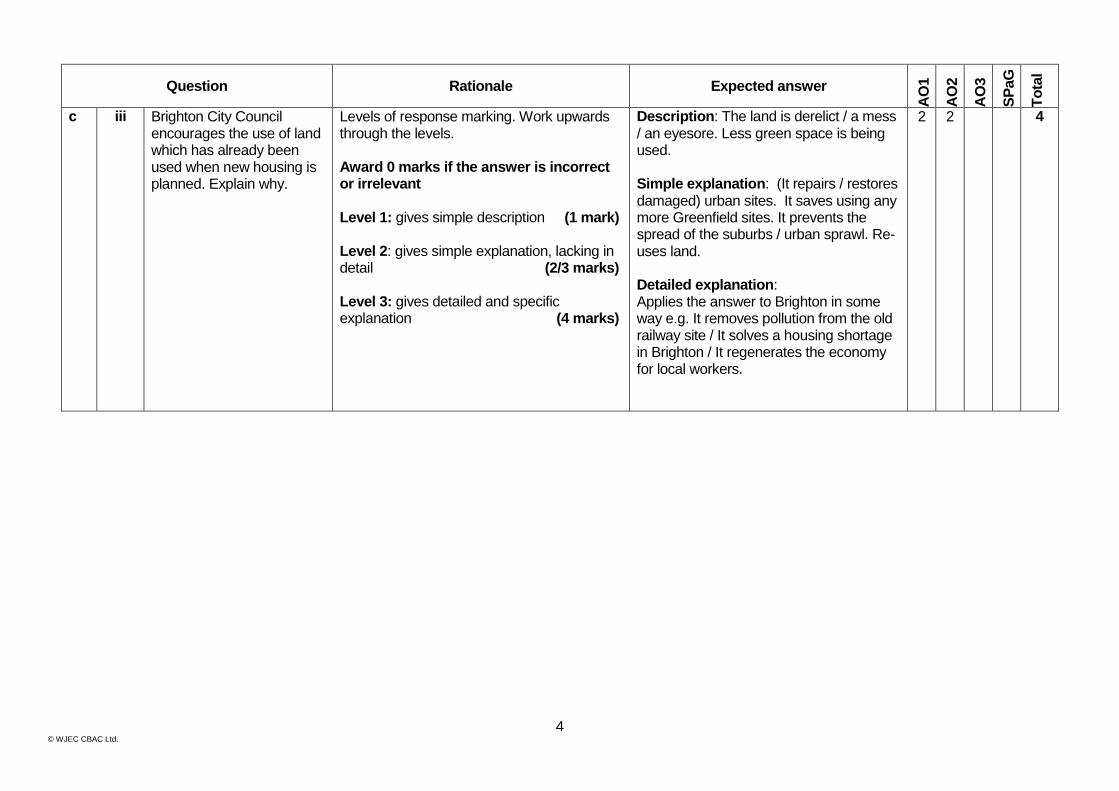
c iii Brighton City Council encourages the use of land which has already been used when new housing is planned. Explain why.
Levels of response marking. Work upwards through the levels. Award 0 marks if the answer is incorrect or irrelevant Level 1: gives simple description (1 mark) Level 2: gives simple explanation, lacking in detail (2/3 marks) Level 3: gives detailed and specific explanation (4 marks)
Description: The land is derelict / a mess / an eyesore. Less green space is being used. Simple explanation: (It repairs / restores damaged) urban sites. It saves using any more Greenfield sites. It prevents the spread of the suburbs / urban sprawl. Re-uses land. Detailed explanation: Applies the answer to Brighton in some way e.g. It removes pollution from the old railway site / It solves a housing shortage in Brighton / It regenerates the economy for local workers.
2 2 4

5 © WJEC CBAC Ltd.
Question Rationale Expected answer
AO
1
AO
2
AO
3
SP
aG
To
tal
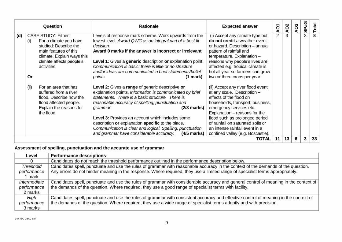
(d) CASE STUDY: Either: (i) For an area of a town or city
which has changed recently. Describe how the area has changed. Explain why the area changed.
Explain why the improvements were needed. Or (ii) For a rural area where the
environment is under pressure from visitors. Describe ways this environment is managed to reduce the pressure caused by visitors. Explain why the management is needed.
Levels of response mark scheme. Work upwards from the lowest level. Award QWC as an integral part of a best fit decision. Award 0 marks if the answer is incorrect or irrelevant
Level 1: Gives a generic description or explanation point. Communication is basic: there is little or no structure and/or ideas are communicated in brief statements/bullet points. (1 mark)
Level 2: Gives a range of generic descriptive or explanation points. Information is communicated by brief statements. There is a basic structure. There is reasonable accuracy of spelling, punctuation and grammar. (2/3 marks)
Level 3: Provides an account which includes some description or explanation specific to the place. Communication is clear and logical. Spelling, punctuation and grammar have considerable accuracy. (4/5 marks)
(i) Accept urban change example located in a country at any level of economic development. Description – location / key facts / features of either urban environment or its population. Explanation – reasons for the changes (e.g. need to improve health /QoL in a shanty town).
(ii) Accept visitor pressure in any rural area / National Park / Coastal area or honeypot site. Could be trampling of sand dunes or footpath erosion in uplands. Description – of the management strategies. Explanation – reasons for damage e.g. explanation of honeypot site or of the processes of footpath erosion.
2 3 3 8
TOTAL 10 13 7 3 33
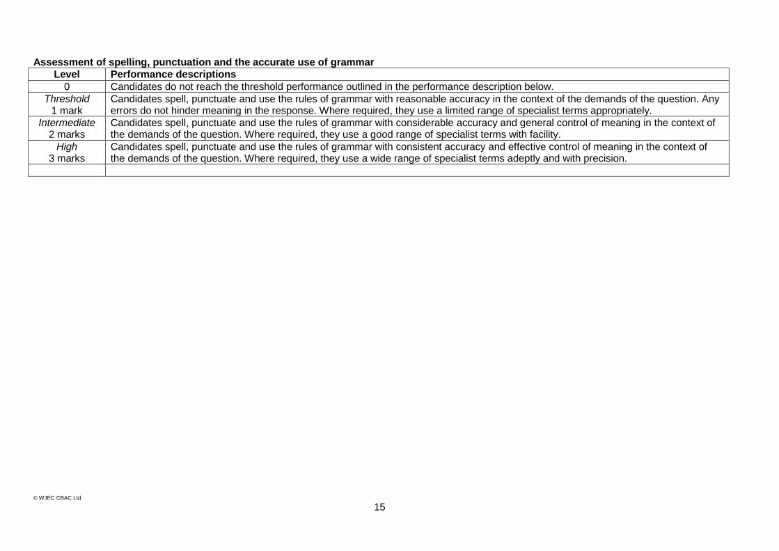
Assessment of spelling, punctuation and the accurate use of grammar
Level Performance descriptions 0 Candidates do not reach the threshold performance outlined in the performance description below.
Threshold performance
1 mark
Candidates spell, punctuate and use the rules of grammar with reasonable accuracy in the context of the demands of the question. Any errors do not hinder meaning in the response. Where required, they use a limited range of specialist terms appropriately.
Intermediate performance
2 marks
Candidates spell, punctuate and use the rules of grammar with considerable accuracy and general control of meaning in the context of the demands of the question. Where required, they use a good range of specialist terms with facility.
High performance
3 marks
Candidates spell, punctuate and use the rules of grammar with consistent accuracy and effective control of meaning in the context of the demands of the question. Where required, they use a wide range of specialist terms adeptly and with precision.
© WJEC CBAC Ltd.
6
2 Question Rationale Expected answer
AO
1
AO
2
AO
3
SP
aG
To
tal
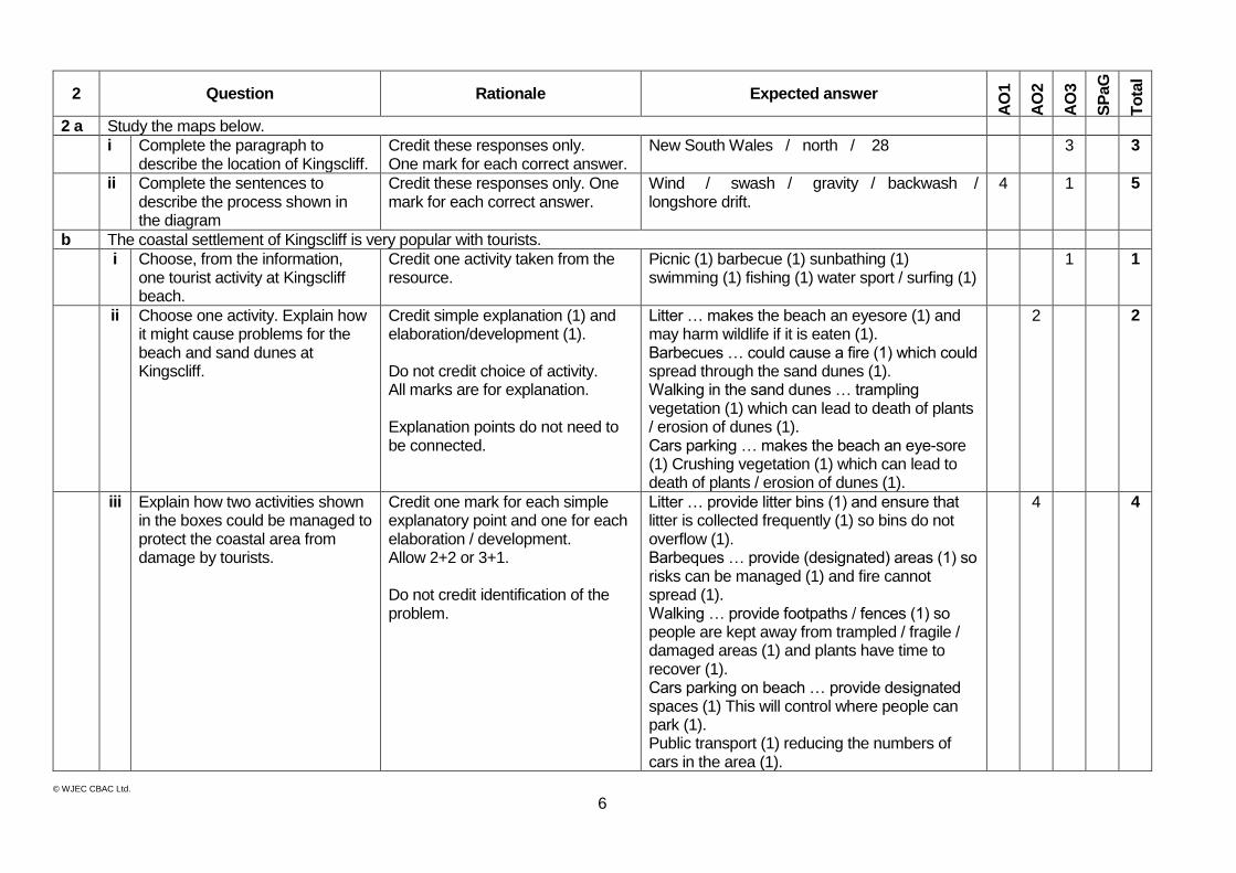
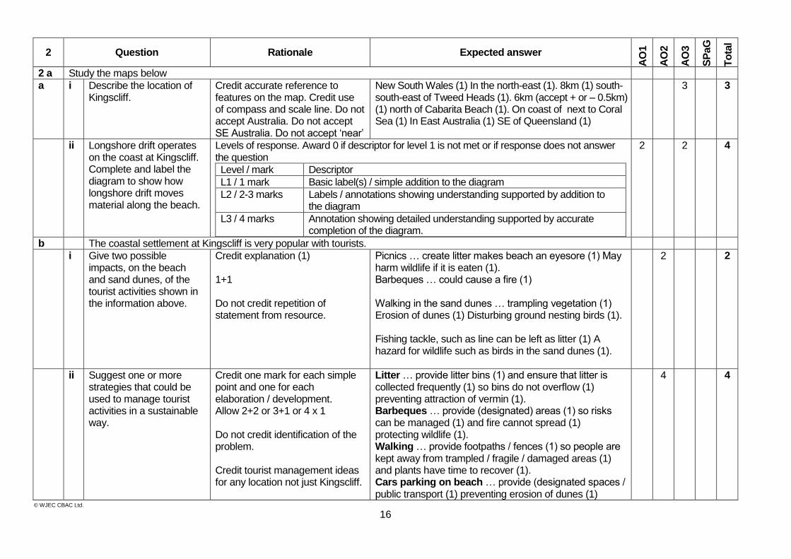
2 a Study the maps below.
i Complete the paragraph to describe the location of Kingscliff.
Credit these responses only. One mark for each correct answer.
New South Wales / north / 28 3 3
ii Complete the sentences to describe the process shown in the diagram
Credit these responses only. One mark for each correct answer.
Wind / swash / gravity / backwash / longshore drift.
4 1 5
b The coastal settlement of Kingscliff is very popular with tourists.
i Choose, from the information, one tourist activity at Kingscliff beach.
Credit one activity taken from the resource.
Picnic (1) barbecue (1) sunbathing (1) swimming (1) fishing (1) water sport / surfing (1)
1 1
ii Choose one activity. Explain how it might cause problems for the beach and sand dunes at Kingscliff.
Credit simple explanation (1) and elaboration/development (1). Do not credit choice of activity. All marks are for explanation. Explanation points do not need to be connected.
Litter … makes the beach an eyesore (1) and may harm wildlife if it is eaten (1). Barbecues … could cause a fire (1) which could spread through the sand dunes (1). Walking in the sand dunes … trampling vegetation (1) which can lead to death of plants / erosion of dunes (1). Cars parking … makes the beach an eye-sore (1) Crushing vegetation (1) which can lead to death of plants / erosion of dunes (1).
2 2
iii Explain how two activities shown in the boxes could be managed to protect the coastal area from damage by tourists.
Credit one mark for each simple explanatory point and one for each elaboration / development. Allow 2+2 or 3+1. Do not credit identification of the problem.
Litter … provide litter bins (1) and ensure that litter is collected frequently (1) so bins do not overflow (1). Barbeques … provide (designated) areas (1) so risks can be managed (1) and fire cannot spread (1). Walking … provide footpaths / fences (1) so people are kept away from trampled / fragile / damaged areas (1) and plants have time to recover (1). Cars parking on beach … provide designated spaces (1) This will control where people can park (1). Public transport (1) reducing the numbers of cars in the area (1).
4 4
© WJEC CBAC Ltd.
7
Question Rationale Expected answer
AO
1
AO
2
AO
3
SP
aG
To
tal
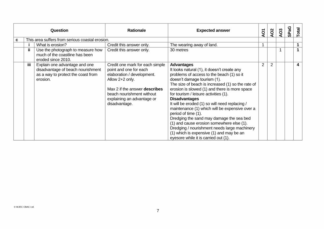
c This area suffers from serious coastal erosion.
i What is erosion? Credit this answer only. The wearing away of land. 1 1
ii Use the photograph to measure how much of the coastline has been eroded since 2010.
Credit this answer only. 30 metres 1 1
iii Explain one advantage and one disadvantage of beach nourishment as a way to protect the coast from erosion.
Credit one mark for each simple point and one for each elaboration / development. Allow 2+2 only. Max 2 if the answer describes beach nourishment without explaining an advantage or disadvantage.
Advantages It looks natural (1), it doesn’t create any problems of access to the beach (1) so it doesn’t damage tourism (1). The size of beach is increased (1) so the rate of erosion is slowed (1) and there is more space for tourism / leisure activities (1). Disadvantages It will be eroded (1) so will need replacing / maintenance (1) which will be expensive over a period of time (1). Dredging the sand may damage the sea bed (1) and cause erosion somewhere else (1). Dredging / nourishment needs large machinery (1) which is expensive (1) and may be an eyesore while it is carried out (1).
2 2 4
© WJEC CBAC Ltd.
8
Question Rationale Expected answer
AO
1
AO
2
AO
3
SP
aG
To
tal
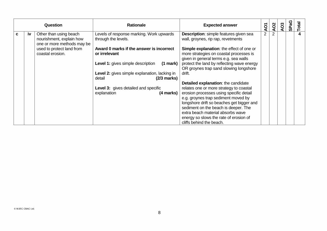
c iv Other than using beach nourishment, explain how one or more methods may be used to protect land from coastal erosion.
Levels of response marking. Work upwards through the levels. Award 0 marks if the answer is incorrect or irrelevant Level 1: gives simple description (1 mark) Level 2: gives simple explanation, lacking in detail (2/3 marks) Level 3: gives detailed and specific explanation (4 marks)
Description: simple features given sea wall, groynes, rip rap, revetments Simple explanation: the effect of one or more strategies on coastal processes is given in general terms e.g. sea walls protect the land by reflecting wave energy OR groynes trap sand slowing longshore drift. Detailed explanation: the candidate relates one or more strategy to coastal erosion processes using specific detail e.g. groynes trap sediment moved by longshore drift so beaches get bigger and sediment on the beach is deeper. The extra beach material absorbs wave energy so slows the rate of erosion of cliffs behind the beach.
2 2 4
© WJEC CBAC Ltd.
9
Question Rationale Expected answer
AO
1
AO
2
AO
3
SP
aG
To
tal
(d) CASE STUDY: Either: (i) For a climate you have
studied: Describe the main features of this climate. Explain ways this climate affects people’s activities.
Or (ii) For an area that has
suffered from a river flood. Describe how the flood affected people. Explain the reasons for the flood.
Levels of response mark scheme. Work upwards from the lowest level. Award QWC as an integral part of a best fit decision. Award 0 marks if the answer is incorrect or irrelevant Level 1: Gives a generic description or explanation point. Communication is basic: there is little or no structure and/or ideas are communicated in brief statements/bullet points. (1 mark)
Level 2: Gives a range of generic descriptive or explanation points. Information is communicated by brief statements. There is a basic structure. There is reasonable accuracy of spelling, punctuation and grammar. (2/3 marks)
Level 3: Provides an account which includes some description or explanation specific to the place. Communication is clear and logical. Spelling, punctuation and grammar have considerable accuracy. (4/5 marks)
(i) Accept any climate type but do not credit a weather event or hazard. Description – annual pattern of rainfall and temperature. Explanation – reasons why people’s lives are affected e.g. tropical climate is hot all year so farmers can grow two or three crops per year. (ii) Accept any river flood event at any scale. Description – effects of the flood on households, transport, business, emergency services etc. Explanation – reasons for the flood such as prolonged period of rainfall on saturated soils or an intense rainfall event in a confined valley (e.g. Boscastle).
2 3 3 8
TOTAL 11 13 6 3 33
Assessment of spelling, punctuation and the accurate use of grammar
Level Performance descriptions
0 Candidates do not reach the threshold performance outlined in the performance description below.
Threshold performance
1 mark
Candidates spell, punctuate and use the rules of grammar with reasonable accuracy in the context of the demands of the question. Any errors do not hinder meaning in the response. Where required, they use a limited range of specialist terms appropriately.
Intermediate performance
2 marks
Candidates spell, punctuate and use the rules of grammar with considerable accuracy and general control of meaning in the context of the demands of the question. Where required, they use a good range of specialist terms with facility.
High performance
3 marks
Candidates spell, punctuate and use the rules of grammar with consistent accuracy and effective control of meaning in the context of the demands of the question. Where required, they use a wide range of specialist terms adeptly and with precision.
© WJEC CBAC Ltd.
10
UNIT 4241/02 – Unit 1 Higher Tier - Summer 2013
1 Question Rationale Expected answer
AO
1
AO
2
AO
3
SP
aG
To
tal
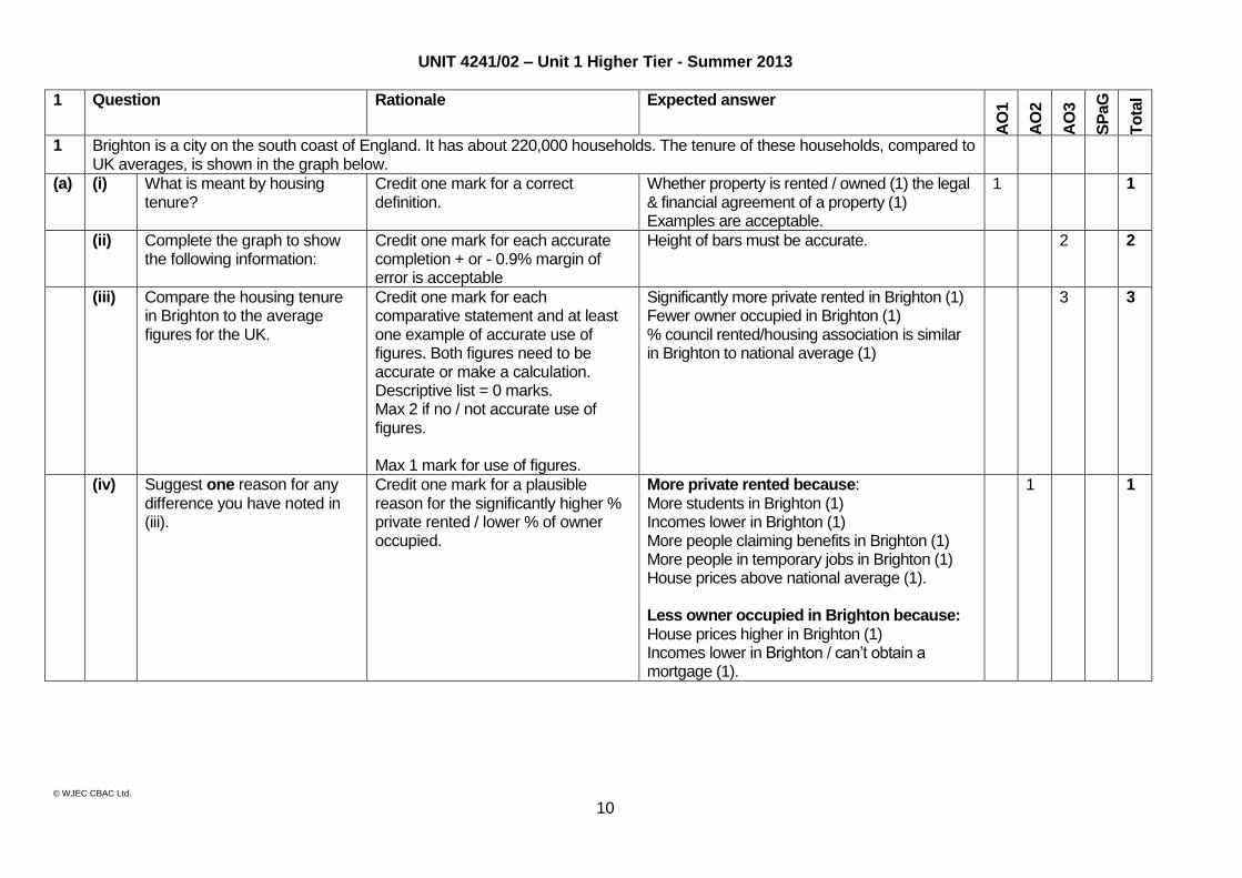
1 Brighton is a city on the south coast of England. It has about 220,000 households. The tenure of these households, compared to UK averages, is shown in the graph below.
(a) (i) What is meant by housing tenure?
Credit one mark for a correct definition.
Whether property is rented / owned (1) the legal & financial agreement of a property (1) Examples are acceptable.
1 1
(ii) Complete the graph to show the following information:
Credit one mark for each accurate completion + or - 0.9% margin of error is acceptable
Height of bars must be accurate. 2 2
(iii) Compare the housing tenure in Brighton to the average figures for the UK.
Credit one mark for each comparative statement and at least one example of accurate use of figures. Both figures need to be accurate or make a calculation. Descriptive list = 0 marks. Max 2 if no / not accurate use of figures. Max 1 mark for use of figures.
Significantly more private rented in Brighton (1) Fewer owner occupied in Brighton (1) % council rented/housing association is similar in Brighton to national average (1)
3 3
(iv) Suggest one reason for any difference you have noted in (iii).
Credit one mark for a plausible reason for the significantly higher % private rented / lower % of owner occupied.
More private rented because: More students in Brighton (1) Incomes lower in Brighton (1) More people claiming benefits in Brighton (1) More people in temporary jobs in Brighton (1) House prices above national average (1). Less owner occupied in Brighton because: House prices higher in Brighton (1) Incomes lower in Brighton / can’t obtain a mortgage (1).
1 1

© WJEC CBAC Ltd.
11
Question Rationale Expected answer
AO
1
AO
2
AO
3
SP
aG
Tota
l
(b) One Brighton is a new housing development. It is shown on the OS map extract below.
(i) Give a six figure grid reference for One Brighton.
Credit accurate use of accurate six figure reference to one place in third and sixth digit. Accept accurate 8 figure grid references.
311053 1 1
(ii) Residents of One Brighton are encouraged to use sustainable transport. Use map evidence to explain one way they could achieve this.
Credit one mark for an accurate use of map evidence and one mark for an elaboration. (1+1) Must use distance / direction / 4 fig grid reference / or 6 fig (accurate to one place in 3rd and 6th digit)
The development is only 300 + or - 50 m from the rail station (1) at 310050 (1) so they can use the train (1) which gives less emissions/less CO2/uses less fuel (1). The development is 0.9 – 1.5km from the town / city centre (TH) (1) so residents can walk/cycle (1).
1 1 2
(b) (iii) Many residents of One Brighton rent their home from a housing association. Explain two advantage of renting your home.
Credit one mark for each way and one for each explanation. (1+1) x 2
Housing Association rent is set at a ‘fair’ value (1) so tenants find it affordable (1). Repairs are made by the owner (1) so tenants do not have unexpected/ large expenses (1). Contracts may be short (1) so tenants can move house at relatively short notice (1) is easier to move than if you are a home owner (1). Accept renting is cheaper.
3 1 4
© WJEC CBAC Ltd.
12
Question Rationale Expected answer
AO
1
AO
2
AO
3
SP
aG
Tota
l
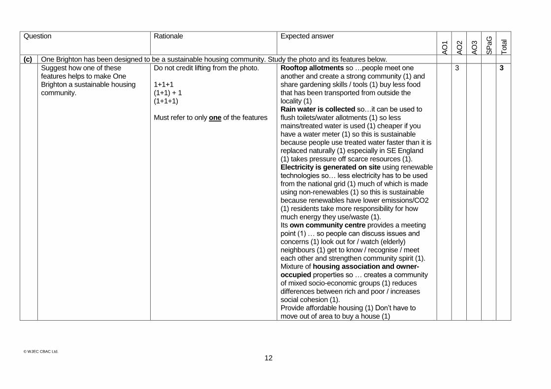
(c) One Brighton has been designed to be a sustainable housing community. Study the photo and its features below.
Suggest how one of these features helps to make One Brighton a sustainable housing community.
Do not credit lifting from the photo. 1+1+1 (1+1) + 1 (1+1+1) Must refer to only one of the features
Rooftop allotments so …people meet one another and create a strong community (1) and share gardening skills / tools (1) buy less food that has been transported from outside the locality (1) Rain water is collected so…it can be used to flush toilets/water allotments (1) so less mains/treated water is used (1) cheaper if you have a water meter (1) so this is sustainable because people use treated water faster than it is replaced naturally (1) especially in SE England (1) takes pressure off scarce resources (1). Electricity is generated on site using renewable technologies so… less electricity has to be used from the national grid (1) much of which is made using non-renewables (1) so this is sustainable because renewables have lower emissions/CO2 (1) residents take more responsibility for how much energy they use/waste (1). Its own community centre provides a meeting point (1) … so people can discuss issues and concerns (1) look out for / watch (elderly) neighbours (1) get to know / recognise / meet each other and strengthen community spirit (1). Mixture of housing association and owner-occupied properties so … creates a community of mixed socio-economic groups (1) reduces differences between rich and poor / increases social cohesion (1). Provide affordable housing (1) Don’t have to move out of area to buy a house (1)
3 3
© WJEC CBAC Ltd.
13
Question Rationale Expected answer
AO
1
AO
2
AO
3
SP
aG
To
tal
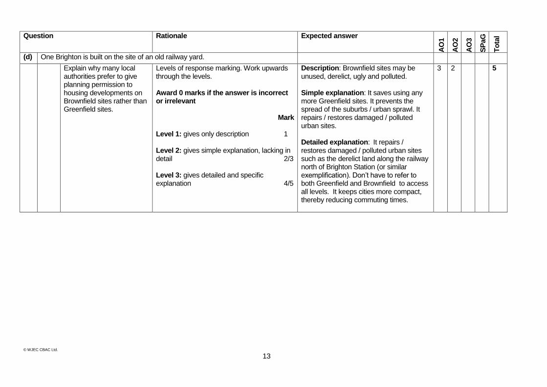
(d) One Brighton is built on the site of an old railway yard.
Explain why many local authorities prefer to give planning permission to housing developments on Brownfield sites rather than Greenfield sites.
Levels of response marking. Work upwards through the levels. Award 0 marks if the answer is incorrect or irrelevant
Mark Level 1: gives only description 1 Level 2: gives simple explanation, lacking in detail 2/3 Level 3: gives detailed and specific explanation 4/5
Description: Brownfield sites may be unused, derelict, ugly and polluted. Simple explanation: It saves using any more Greenfield sites. It prevents the spread of the suburbs / urban sprawl. It repairs / restores damaged / polluted urban sites. Detailed explanation: It repairs / restores damaged / polluted urban sites such as the derelict land along the railway north of Brighton Station (or similar exemplification). Don’t have to refer to both Greenfield and Brownfield to access all levels. It keeps cities more compact, thereby reducing commuting times.
3 2 5

© WJEC CBAC Ltd.
14
Question Rationale Expected answer
AO
1
AO
2
AO
3
SP
aG
To
tal
(e) CASE STUDY: Either: (i) For an area of a town or city that has changed recently: Name the area; Describe how the area has changed; Explain why different groups of people have a range of views on the changes. Or (ii) For a rural area where the environment is under pressure from visitors: Name the area; Describe how visitors have affected the environment; Explain why this management is needed.
Levels of response mark scheme. Work upwards from the lowest level. Award QWC as an integral part of a best fit decision. Award 0 marks if the answer is incorrect or irrelevant 0 groups = L1 = 2; 1 group = L2 = 4 max Max level 1=2 if student writes about a village e.g. in a rural area. Max level 1=2 if student writes about an urban area under pressure from visitors. Must give at least 2 viewpoints to access L3/4. 0 groups max L1=2. Level 1: Gives a range of generic descriptive or explanation points. Information is communicated by brief statements. There is a basic structure. There is reasonable accuracy of spelling, punctuation and grammar. (1/2 marks)
Level 2: Provides an account which includes some description or explanation specific to the place. Communication is clear and logical. Spelling, punctuation and grammar have considerable accuracy. (3/4 marks)
Level 3: Provides an account which includes description and explanation specific to the place. Communication is clear, logical and has structure. Specialist terms are used with proficiency. Spelling, punctuation and grammar have considerable accuracy.
(5/6 marks) Level 4: Provides a balanced account which includes elaborated description and explanation specific to the place. Communication is very clear, sophisticated and well structured. Specialist terms are used adeptly. Spelling, punctuation and grammar have consistent accuracy. (7/8 marks)
Credit reference to any green fields development or urban redevelopment or regeneration project where there are clearly held views by more than one stakeholder e.g. success or otherwise of redevelopment of Stratford area of London for 2012 Olympics. Credit visitor pressure to a rural area / ecosystem / National Park / coastline / honeypot site. The case study could be in the UK (e.g. sand dune ecosystem at Ynyslas) or abroad (e.g. barrier reef). Management strategies must be explained.
3 5 3 11
TOTAL 10 13 7 3 33
© WJEC CBAC Ltd.
15
Assessment of spelling, punctuation and the accurate use of grammar
Level Performance descriptions
0 Candidates do not reach the threshold performance outlined in the performance description below.
Threshold 1 mark
Candidates spell, punctuate and use the rules of grammar with reasonable accuracy in the context of the demands of the question. Any errors do not hinder meaning in the response. Where required, they use a limited range of specialist terms appropriately.
Intermediate 2 marks
Candidates spell, punctuate and use the rules of grammar with considerable accuracy and general control of meaning in the context of the demands of the question. Where required, they use a good range of specialist terms with facility.
High 3 marks
Candidates spell, punctuate and use the rules of grammar with consistent accuracy and effective control of meaning in the context of the demands of the question. Where required, they use a wide range of specialist terms adeptly and with precision.
© WJEC CBAC Ltd.
16
2 Question Rationale Expected answer
AO
1
AO
2
AO
3
SP
aG
To
tal
2 a Study the maps below
a i Describe the location of Kingscliff.
Credit accurate reference to features on the map. Credit use of compass and scale line. Do not accept Australia. Do not accept SE Australia. Do not accept ‘near’
New South Wales (1) In the north-east (1). 8km (1) south-south-east of Tweed Heads (1). 6km (accept + or – 0.5km) (1) north of Cabarita Beach (1). On coast of next to Coral Sea (1) In East Australia (1) SE of Queensland (1)
3 3
ii Longshore drift operates on the coast at Kingscliff. Complete and label the diagram to show how longshore drift moves material along the beach.
Levels of response. Award 0 if descriptor for level 1 is not met or if response does not answer the question
Level / mark Descriptor
L1 / 1 mark Basic label(s) / simple addition to the diagram
L2 / 2-3 marks Labels / annotations showing understanding supported by addition to the diagram
L3 / 4 marks Annotation showing detailed understanding supported by accurate completion of the diagram.
2 2 4
b The coastal settlement at Kingscliff is very popular with tourists.
i Give two possible impacts, on the beach and sand dunes, of the tourist activities shown in the information above.
Credit explanation (1) 1+1 Do not credit repetition of statement from resource.
Picnics … create litter makes beach an eyesore (1) May harm wildlife if it is eaten (1). Barbeques … could cause a fire (1) Walking in the sand dunes … trampling vegetation (1) Erosion of dunes (1) Disturbing ground nesting birds (1). Fishing tackle, such as line can be left as litter (1) A hazard for wildlife such as birds in the sand dunes (1).
2 2
ii Suggest one or more strategies that could be used to manage tourist activities in a sustainable way.
Credit one mark for each simple point and one for each elaboration / development. Allow 2+2 or 3+1 or 4 x 1 Do not credit identification of the problem. Credit tourist management ideas for any location not just Kingscliff.
Litter … provide litter bins (1) and ensure that litter is collected frequently (1) so bins do not overflow (1) preventing attraction of vermin (1). Barbeques … provide (designated) areas (1) so risks can be managed (1) and fire cannot spread (1) protecting wildlife (1). Walking … provide footpaths / fences (1) so people are kept away from trampled / fragile / damaged areas (1) and plants have time to recover (1). Cars parking on beach … provide (designated spaces / public transport (1) preventing erosion of dunes (1)
4 4
© WJEC CBAC Ltd.
17
Question Rationale Expected answer
AO
1
AO
2
AO
3
SP
aG
To
tal
c Study the photograph below. It was taken in 2011. It shows an area of Kingscliff that has been affected by erosion.
i What is erosion? Basic response must convey denudation. Do not accept examples / types of erosion without a definition.
The wearing away of the land (1) 1 1
ii Use the photograph to measure how far the coastline has retreated.
Allow within +/- 10 metres 30 metres. 1 1
iii Explain one advantage or one disadvantage of beach nourishment as a way to protect the coast from erosion.
Credit one mark for each simple point and one for each elaboration / development. No mark if the answer describes beach nourishment without explaining an advantage or disadvantage.
Advantages It looks natural (1), it doesn’t create any problems of access to the beach (1) so it doesn’t damage tourism (1). It is effective in reducing erosion (1) It absorbs more energy (1) The size of beach is increased (1) so the rate of erosion is slowed (1) and there is more space for tourism / leisure activities (1). Disadvantages It will be eroded (1) so will need replacing / maintenance (1) which is expensive (1). Dredging the sand may damage the sea bed (1) and cause erosion somewhere else (1). Dredging / nourishment needs large machinery (1) which is expensive (1) and may be an eyesore while it is carried out (1).
1 1 2
© WJEC CBAC Ltd.
18
Question Rationale Expected answer
AO
1
AO
2
AO
3
SP
aG
To
tal
c iv Other than using beach nourishment, explain how one or more methods may be used to protect land from coastal erosion.
Levels of response marking. Work upwards through the levels. Award 0 marks if the answer is incorrect or irrelevant. 0 groups = L1 = 2; 1 group = L2 = 4 max Level 1: gives only description (1 mark) Level 2: gives simple explanation, lacking in detail (2/3 marks) Level 3: gives detailed and specific explanation (4/5 marks)
Description: simple features given sea wall, groynes, rip rap, revetments Simple explanation: the effect of one or more strategies on coastal processes are given in general terms e.g. sea walls protect the land by reflecting wave energy OR groynes trap sand so beaches get bigger. Detailed explanation: the candidate relates one or more strategy to coastal erosion processes using specific detail e.g. groynes trap sediment moved by Longshore drift so beaches get bigger and sediment on the beach is deeper. The extra beach material absorbs wave energy so slows the rate of erosion of cliffs behind the beach. Give credit where candidates evaluate effectiveness of strategy.
3 2 5
© WJEC CBAC Ltd.
19
Question Rationale Expected answer
AO
1
AO
2
AO
3
SP
aG
To
tal
(d) CASE STUDY: Either: (i) Name and locate a
climate you have studied. Describe the main features of this climate. Explain ways it affects the activities of different groups of people.
Or (ii) Name an area that
has suffered from a river flood. Describe how the flood affected different groups of people. Explain the reasons for the flood.
Levels of response mark scheme. Work upwards from the lowest level. Award QWC as an integral part of a best fit decision. Award 0 marks if the answer is incorrect or irrelevant.
0 groups max L1=2 1 group max L2=4
Level 1: Gives a range of generic descriptive or explanation points. Information is communicated by brief statements. There is a basic structure. There is reasonable accuracy of spelling, punctuation and grammar. (1/2 marks)
Level 2: Provides an account which includes some description or explanation specific to the place. Communication is clear and logical. Spelling, punctuation and grammar have considerable accuracy. (3/4 marks)
Level 3: Provides an account which includes description and explanation specific to the place. Communication is clear, logical and has structure. Specialist terms are used with proficiency. Spelling, punctuation and grammar have considerable accuracy.
(5/6 marks)
Level 4: Provides a balanced account which includes elaborated description and explanation specific to the place. Communication is very clear, sophisticated and well structured. Specialist terms are used adeptly. Spelling, punctuation and grammar have consistent accuracy. (7/8 marks)
(i) Accept any climate type but do not credit a weather event or hazard. Description – annual pattern of rainfall and temperature. Explanation – reasons why people’s lives are affected e.g. tropical climate is hot all year so farmers can grow two or three crops per year. (ii) Accept any river flood event at any scale. Description – effects of the flood on households, transport, business, emergency services etc. Explanation – reasons for the flood such as prolonged period of rainfall on saturated soils or an intense rainfall event in a confined valley (e.g. Boscastle).
3 5 3 11
TOTAL 10 14 6 3 33
Assessment of spelling, punctuation and the accurate use of grammar Level Performance descriptions
0 Candidates do not reach the threshold performance outlined in the performance description below. Threshold
1 mark Candidates spell, punctuate and use the rules of grammar with reasonable accuracy in the context of the demands of the question. Any errors do not hinder meaning in the response. Where required, they use a limited range of specialist terms appropriately.
Intermediate 2 marks
Candidates spell, punctuate and use the rules of grammar with considerable accuracy and general control of meaning in the context of the demands of the question. Where required, they use a good range of specialist terms with facility.
High 3 marks
Candidates spell, punctuate and use the rules of grammar with consistent accuracy and effective control of meaning in the context of the demands of the question. Where required, they use a wide range of specialist terms adeptly and with precision.
© WJEC CBAC Ltd.
20
UNIT 4242/01 – Unit 2 Section A Foundation Tier - Summer 2-13
Question Rationale Expected answer
AO
1
AO
2
AO
3
SP
aG
To
tal
1 Study the diagram below that shows the greenhouse effect.
a i Describe how the greenhouse effect works by adding letters from the box to label the diagram above.
Credit one mark for each correctly labelled box.
From left to right B C D F
4 4
ii Tick two boxes to show two other human activities which are sources of greenhouse gases.
Credit one mark for each correct box, however identified.
Cars and aeroplanes Landfill sites
2 2
iii Explain two ways that an increase in global temperatures is affecting people.
Credit one mark for each simple point and one for each elaboration / development. However, do not credit simple statements (such as melting ice) unless qualified by link to people. Allow 2+2. Credit positive or negative impact.
Increased storms / rainfall (1) leading to flooding (1) and damage to property (1) wind/water damage to crops (1). Melting ice (1) leading to sea level rise (1) and flooding of farmland / homes (1) and environmental refugees (1) Decreased rainfall (1) leading to drought/ wildfires/ desertification (1) which may threaten water supply (1) or damage crops/ famine (1). Spread of disease (1) malaria / mosquitoes (1) lowers life expectancy (1) Less snowfall (1) fewer tourists (1) fewer resorts (1) Increased temperatures (1) longer growing season (1) increase in domestic tourism (1) higher air con bills (1) Changing lifestyles (1) higher air con bills (1)need for international agreements (1)
2 2 4
b Study the information about the Altai Mountains
i Circle the correct answers in the passage below to describe how the January temperature in the Altai Mountains changed since 1966.
Credit one mark for each correct answer, however identified.
1991 1.4
2 2
ii Suggest two reasons why plant growth is difficult in mountain environments such as this.
Credit two simple statements
Thin/rocky soils (1) Too cold (1) Snow and ice rather than water (1) No available water (1) Soil low in nutrients (1)
2 2
© WJEC CBAC Ltd.
21
Question Rationale Expected answer
AO
1
AO
2
AO
3
SP
aG
To
tal
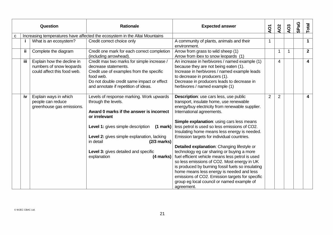
c Increasing temperatures have affected the ecosystem in the Altai Mountains
i What is an ecosystem? Credit correct choice only A community of plants, animals and their environment.
1 1
ii Complete the diagram Credit one mark for each correct completion (including arrowhead).
Arrow from grass to wild sheep (1) Arrow from ibex to snow leopards (1)
1 1 2
iii Explain how the decline in numbers of snow leopards could affect this food web.
Credit max two marks for simple increase / decrease statements. Credit use of examples from the specific food web. Do not double credit same impact or effect and annotate if repetition of ideas.
An increase in herbivores / named example (1) because they are not being eaten (1). Increase in herbivores / named example leads to decrease in producers (1). Decrease in producers leads to decrease in herbivores / named example (1)
4 4
iv Explain ways in which people can reduce greenhouse gas emissions.
Levels of response marking. Work upwards through the levels. Award 0 marks if the answer is incorrect or irrelevant Level 1: gives simple description (1 mark) Level 2: gives simple explanation, lacking in detail (2/3 marks) Level 3: gives detailed and specific explanation (4 marks)
Description: use cars less, use public transport, insulate home, use renewable energy/buy electricity from renewable supplier. International agreements. Simple explanation: using cars less means less petrol is used so less emissions of CO2. Insulating home means less energy is needed. Emission targets for individual countries. Detailed explanation: Changing lifestyle or technology eg car sharing or buying a more fuel efficient vehicle means less petrol is used so less emissions of CO2. Most energy in UK is produced by burning fossil fuels so insulating home means less energy is needed and less emissions of CO2. Emission targets for specific group eg local council or named example of agreement.
2 2 4
© WJEC CBAC Ltd.
22
Question Rationale Expected answer
AO
1
AO
2
AO
3
SP
aG
To
tal
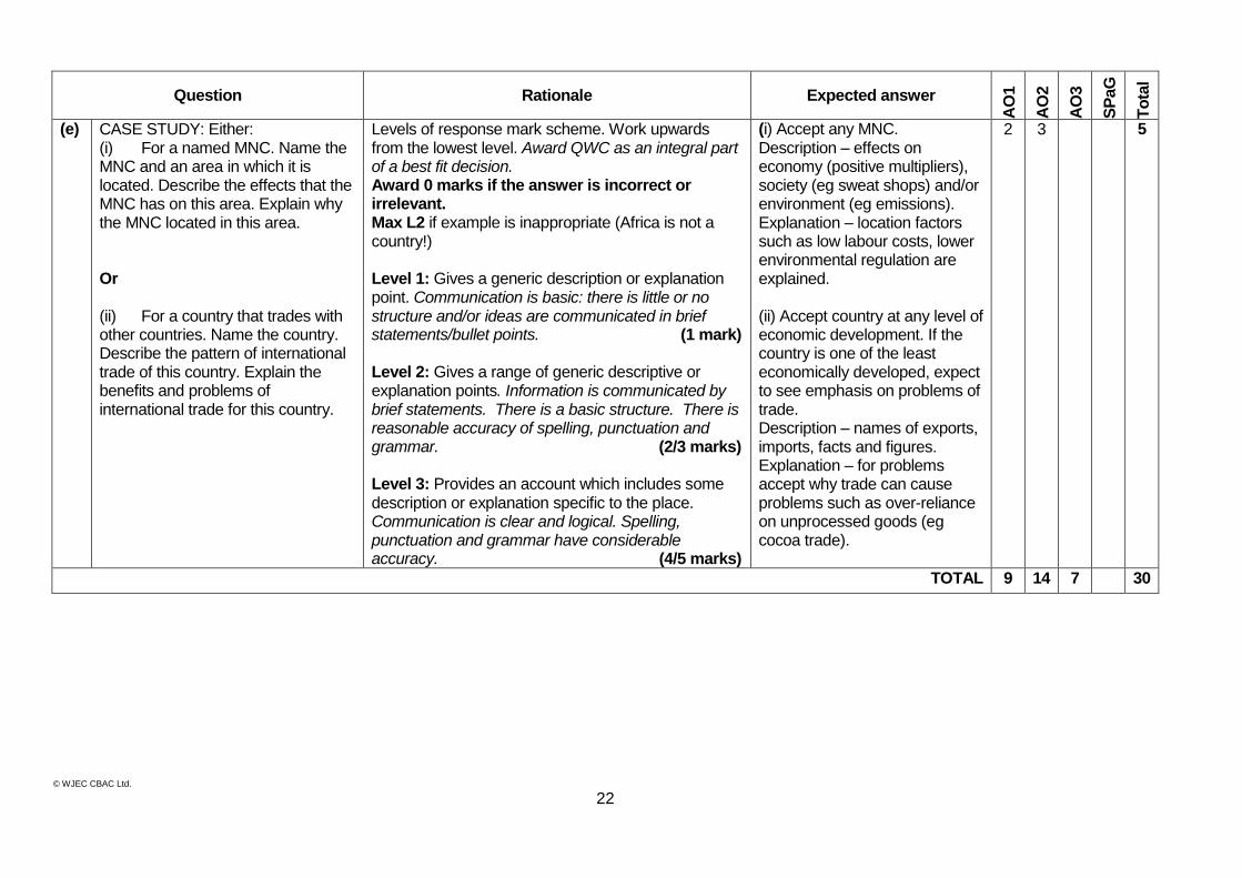
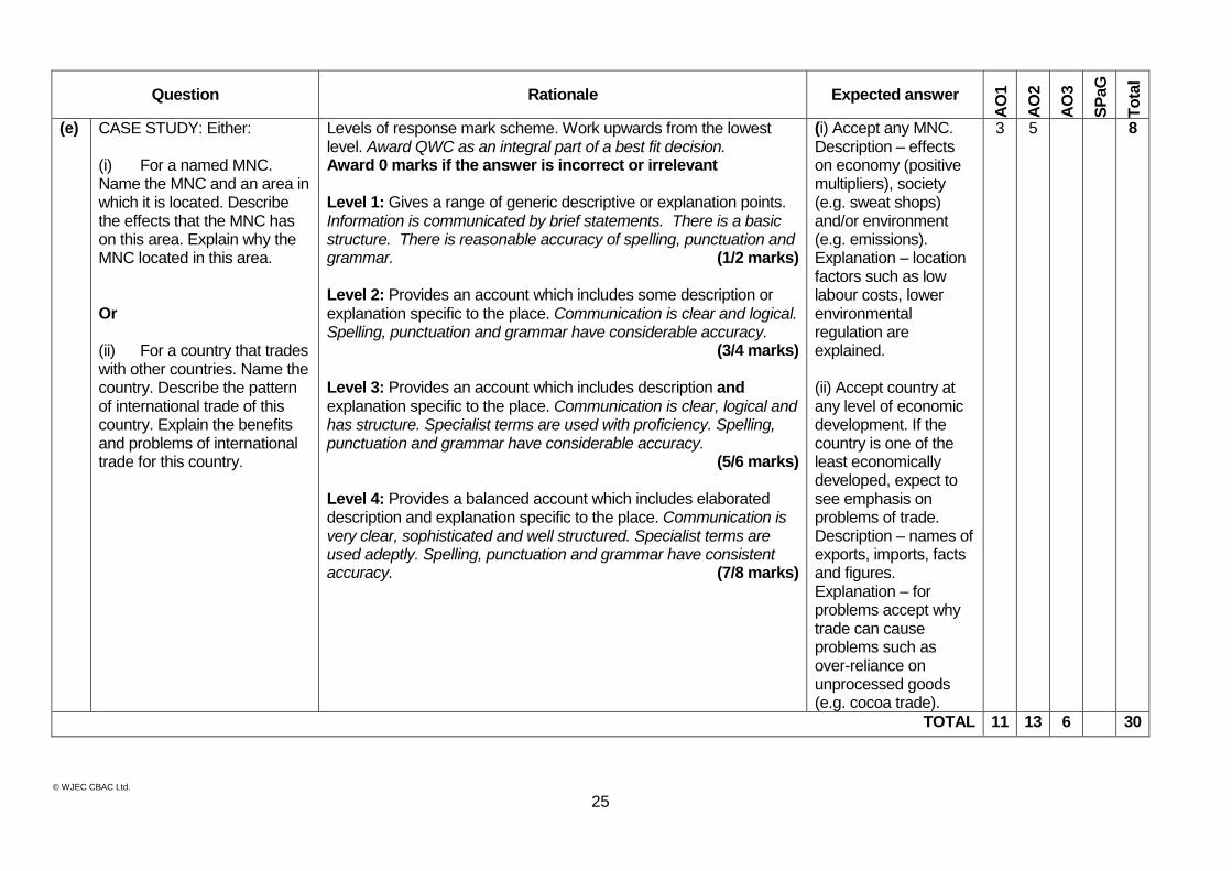
(e) CASE STUDY: Either: (i) For a named MNC. Name the MNC and an area in which it is located. Describe the effects that the MNC has on this area. Explain why the MNC located in this area. Or (ii) For a country that trades with other countries. Name the country. Describe the pattern of international trade of this country. Explain the benefits and problems of international trade for this country.
Explain how the area is being managed
Levels of response mark scheme. Work upwards from the lowest level. Award QWC as an integral part of a best fit decision. Award 0 marks if the answer is incorrect or irrelevant. Max L2 if example is inappropriate (Africa is not a country!) Level 1: Gives a generic description or explanation point. Communication is basic: there is little or no structure and/or ideas are communicated in brief statements/bullet points. (1 mark)
Level 2: Gives a range of generic descriptive or explanation points. Information is communicated by brief statements. There is a basic structure. There is reasonable accuracy of spelling, punctuation and grammar. (2/3 marks)
Level 3: Provides an account which includes some description or explanation specific to the place. Communication is clear and logical. Spelling, punctuation and grammar have considerable accuracy. (4/5 marks)
(i) Accept any MNC. Description – effects on economy (positive multipliers), society (eg sweat shops) and/or environment (eg emissions). Explanation – location factors such as low labour costs, lower environmental regulation are explained. (ii) Accept country at any level of economic development. If the country is one of the least economically developed, expect to see emphasis on problems of trade. Description – names of exports, imports, facts and figures. Explanation – for problems accept why trade can cause problems such as over-reliance on unprocessed goods (eg cocoa trade).
2 3 5
TOTAL 9 14 7 30
© WJEC CBAC Ltd.
23
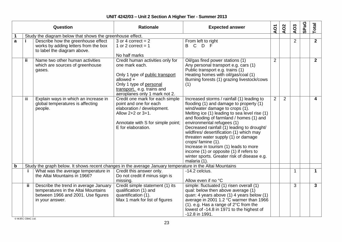
UNIT 4242/03 – Unit 2 Section A Higher Tier - Summer 2013
Question Rationale Expected answer
AO
1
AO
2
AO
3
SP
aG
To
tal
1 Study the diagram below that shows the greenhouse effect. a i Describe how the greenhouse effect
works by adding letters from the box to label the diagram above.
3 or 4 correct = 2 1 or 2 correct = 1 No half marks
From left to right B C D F
2 2
ii Name two other human activities which are sources of greenhouse gases.
Credit human activities only for one mark each. Only 1 type of public transport allowed + Only 1 type of personal transport. e.g. trains and aeroplanes only 1 mark not 2.
Oil/gas fired power stations (1) Any personal transport e.g. cars (1) Public transport e.g. trains (1) Heating homes with oil/gas/coal (1) Burning forests (1) grazing livestock/cows (1)
2 2
iii Explain ways in which an increase in global temperatures is affecting people.
Credit one mark for each simple point and one for each elaboration / development. Allow 2+2 or 3+1. Annotate with S for simple point; E for elaboration.
Increased storms / rainfall (1) leading to flooding (1) and damage to property (1) wind/water damage to crops (1). Melting ice (1) leading to sea level rise (1) and flooding of farmland / homes (1) and environmental refugees (1) Decreased rainfall (1) leading to drought/ wildfires/ desertification (1) which may threaten water supply (1) or damage crops/ famine (1). Increase in tourism (1) leads to more income (1) or opposite (1) if refers to winter sports. Greater risk of disease e.g. malaria (1).
2 2 4
b Study the graph below. It shows recent changes in the average January temperature in the Altai Mountains i What was the average temperature in
the Altai Mountains in 1966? Credit this answer only. Do not credit if minus sign is missing.
-14.2 celcius. Allow even if no °C
1 1
ii Describe the trend in average January temperatures in the Altai Mountains between 1966 and 2001. Use figures in your answer.
Credit simple statement (1) its qualification (1) and quantification (1). Max 1 mark for list of figures
simple: fluctuated (1) risen overall (1) qual: below then above average (1) quan: 4 years above (1) 4 years below (1) average in 2001 1.2 °C warmer than 1966 (1). e.g. Has a range of 2°C from the lowest of -14.8 in 1971 to the highest of -12.8 in 1991.
3 3
© WJEC CBAC Ltd.
24
Question Rationale Expected answer
AO
1
AO
2
AO
3
SP
aG
To
tal
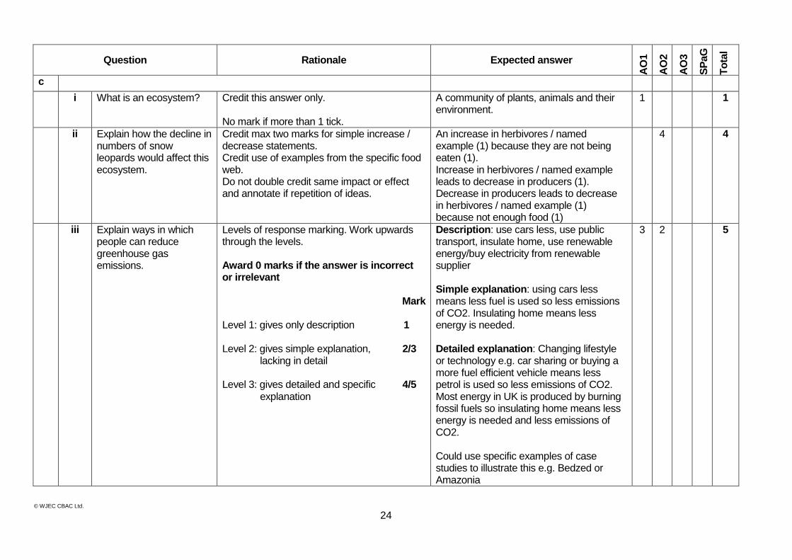
c
i What is an ecosystem? Credit this answer only. No mark if more than 1 tick.
A community of plants, animals and their environment.
1 1
ii Explain how the decline in numbers of snow leopards would affect this ecosystem.
Credit max two marks for simple increase / decrease statements. Credit use of examples from the specific food web. Do not double credit same impact or effect and annotate if repetition of ideas.
An increase in herbivores / named example (1) because they are not being eaten (1). Increase in herbivores / named example leads to decrease in producers (1). Decrease in producers leads to decrease in herbivores / named example (1) because not enough food (1)
4 4
iii Explain ways in which people can reduce greenhouse gas emissions.
Levels of response marking. Work upwards through the levels. Award 0 marks if the answer is incorrect or irrelevant
Mark Level 1: gives only description 1 Level 2: gives simple explanation, 2/3 lacking in detail Level 3: gives detailed and specific 4/5 explanation
Description: use cars less, use public transport, insulate home, use renewable energy/buy electricity from renewable supplier Simple explanation: using cars less means less fuel is used so less emissions of CO2. Insulating home means less energy is needed. Detailed explanation: Changing lifestyle or technology e.g. car sharing or buying a more fuel efficient vehicle means less petrol is used so less emissions of CO2. Most energy in UK is produced by burning fossil fuels so insulating home means less energy is needed and less emissions of CO2. Could use specific examples of case studies to illustrate this e.g. Bedzed or Amazonia
3 2 5
© WJEC CBAC Ltd.
25
Question Rationale Expected answer
AO
1
AO
2
AO
3
SP
aG
To
tal
(e) CASE STUDY: Either: (i) For a named MNC. Name the MNC and an area in which it is located. Describe the effects that the MNC has on this area. Explain why the MNC located in this area. Or (ii) For a country that trades with other countries. Name the country. Describe the pattern of international trade of this country. Explain the benefits and problems of international trade for this country.
Levels of response mark scheme. Work upwards from the lowest level. Award QWC as an integral part of a best fit decision. Award 0 marks if the answer is incorrect or irrelevant Level 1: Gives a range of generic descriptive or explanation points. Information is communicated by brief statements. There is a basic structure. There is reasonable accuracy of spelling, punctuation and grammar. (1/2 marks)
Level 2: Provides an account which includes some description or explanation specific to the place. Communication is clear and logical. Spelling, punctuation and grammar have considerable accuracy.
(3/4 marks)
Level 3: Provides an account which includes description and explanation specific to the place. Communication is clear, logical and has structure. Specialist terms are used with proficiency. Spelling, punctuation and grammar have considerable accuracy.
(5/6 marks) Level 4: Provides a balanced account which includes elaborated description and explanation specific to the place. Communication is very clear, sophisticated and well structured. Specialist terms are used adeptly. Spelling, punctuation and grammar have consistent accuracy. (7/8 marks)
(i) Accept any MNC. Description – effects on economy (positive multipliers), society (e.g. sweat shops) and/or environment (e.g. emissions). Explanation – location factors such as low labour costs, lower environmental regulation are explained. (ii) Accept country at any level of economic development. If the country is one of the least economically developed, expect to see emphasis on problems of trade. Description – names of exports, imports, facts and figures. Explanation – for problems accept why trade can cause problems such as over-reliance on unprocessed goods (e.g. cocoa trade).
3 5 8
TOTAL 11 13 6 30
© WJEC CBAC Ltd.
26
UNIT 4242/02 – Unit 2 Section B Foundation Tier - Summer 2013
Part A
Question Rationale Expected answer
AO
1
AO
2
AO
3
SP
aG
To
tal
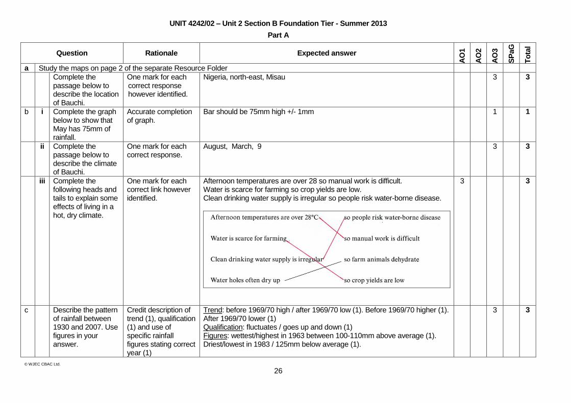
a Study the maps on page 2 of the separate Resource Folder
Complete the passage below to describe the location of Bauchi.
One mark for each correct response however identified.
Nigeria, north-east, Misau 3 3
b i Complete the graph below to show that May has 75mm of rainfall.
Accurate completion of graph.
Bar should be 75mm high +/- 1mm 1 1
ii Complete the passage below to describe the climate of Bauchi.
One mark for each correct response.
August, March, 9 3 3
iii Complete the following heads and tails to explain some effects of living in a hot, dry climate.
One mark for each correct link however identified.
Afternoon temperatures are over 28 so manual work is difficult. Water is scarce for farming so crop yields are low. Clean drinking water supply is irregular so people risk water-borne disease.
3 3
c Describe the pattern of rainfall between 1930 and 2007. Use figures in your answer.
Credit description of trend (1), qualification (1) and use of specific rainfall figures stating correct year (1)
Trend: before 1969/70 high / after 1969/70 low (1). Before 1969/70 higher (1). After 1969/70 lower (1) Qualification: fluctuates / goes up and down (1) Figures: wettest/highest in 1963 between 100-110mm above average (1). Driest/lowest in 1983 / 125mm below average (1).
3 3
© WJEC CBAC Ltd.
27
Question Rationale Expected answer
AO
1
AO
2
AO
3
SP
aG
To
tal
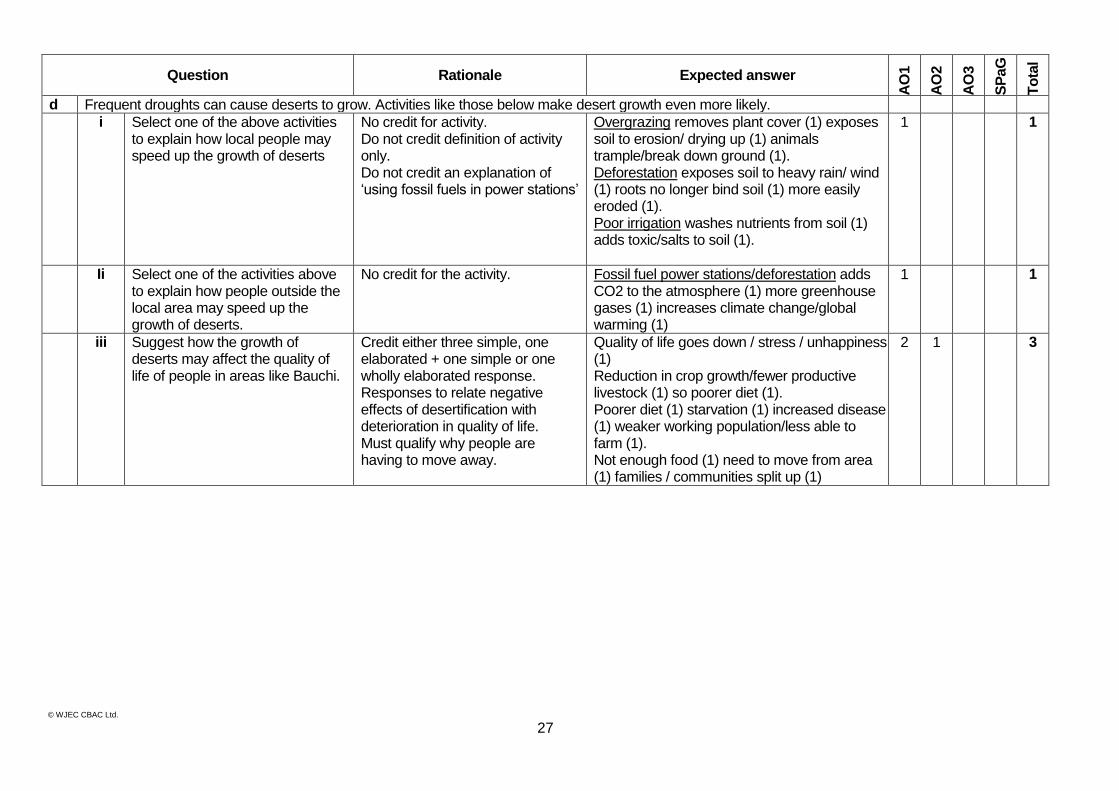
d Frequent droughts can cause deserts to grow. Activities like those below make desert growth even more likely.
i Select one of the above activities to explain how local people may speed up the growth of deserts
No credit for activity. Do not credit definition of activity only. Do not credit an explanation of ‘using fossil fuels in power stations’
Overgrazing removes plant cover (1) exposes soil to erosion/ drying up (1) animals trample/break down ground (1). Deforestation exposes soil to heavy rain/ wind (1) roots no longer bind soil (1) more easily eroded (1). Poor irrigation washes nutrients from soil (1) adds toxic/salts to soil (1).
1 1
Ii Select one of the activities above to explain how people outside the local area may speed up the growth of deserts.
No credit for the activity.
Fossil fuel power stations/deforestation adds CO2 to the atmosphere (1) more greenhouse gases (1) increases climate change/global warming (1)
1 1
iii Suggest how the growth of deserts may affect the quality of life of people in areas like Bauchi.
Credit either three simple, one elaborated + one simple or one wholly elaborated response. Responses to relate negative effects of desertification with deterioration in quality of life. Must qualify why people are having to move away.
Quality of life goes down / stress / unhappiness (1) Reduction in crop growth/fewer productive livestock (1) so poorer diet (1). Poorer diet (1) starvation (1) increased disease (1) weaker working population/less able to farm (1). Not enough food (1) need to move from area (1) families / communities split up (1)
2 1 3
© WJEC CBAC Ltd.
28
Question Rationale Expected answer
AO
1
AO
2
AO
3
SP
aG
To
tal
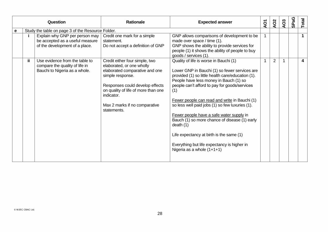
e Study the table on page 3 of the Resource Folder.
i Explain why GNP per person may be accepted as a useful measure of the development of a place.
Credit one mark for a simple statement. Do not accept a definition of GNP
GNP allows comparisons of development to be made over space / time (1). GNP shows the ability to provide services for people (1) it shows the ability of people to buy goods / services (1).
1 1
ii Use evidence from the table to compare the quality of life in Bauchi to Nigeria as a whole.
Credit either four simple, two elaborated, or one wholly elaborated comparative and one simple response. Responses could develop effects on quality of life of more than one indicator. Max 2 marks if no comparative statements.
Quality of life is worse in Bauchi (1) Lower GNP in Bauchi (1) so fewer services are provided (1) so little health care/education (1). People have less money in Bauch (1) so people can’t afford to pay for goods/services (1) Fewer people can read and write in Bauchi (1) so less well paid jobs (1) so few luxuries (1). Fewer people have a safe water supply in Bauch (1) so more chance of disease (1) early death (1) Life expectancy at birth is the same (1) Everything but life expectancy is higher in Nigeria as a whole (1+1+1)
1 2 1 4
© WJEC CBAC Ltd.
29
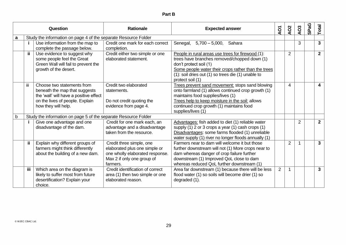
Part B
Question Rationale Expected answer
AO
1
AO
2
AO
3
SP
aG
To
tal
a Study the information on page 4 of the separate Resource Folder
i Use information from the map to complete the passage below.
Credit one mark for each correct completion.
Senegal, 5,700 – 5,000, Sahara 3 3
ii Use evidence to suggest why some people feel the Great Green Wall will fail to prevent the growth of the desert.
Credit either two simple or one elaborated statement.
People in rural areas use trees for firewood (1): trees have branches removed/chopped down (1) don’t protect soil (1) Some people water their crops rather than the trees (1): soil dries out (1) so trees die (1) unable to protect soil (1)
2 2
iii Choose two statements from beneath the map that suggests the ‘wall’ will have a positive effect on the lives of people. Explain how they will help.
Credit two elaborated statements. Do not credit quoting the evidence from page 4.
Trees prevent sand movement: stops sand blowing onto farmland (1) allows continued crop growth (1) maintains food supplies/lives (1) Trees help to keep moisture in the soil: allows continued crop growth (1) maintains food supplies/lives (1)
4 4
b Study the information on page 5 of the separate Resource Folder
i Give one advantage and one disadvantage of the dam.
Credit for one mark each, an advantage and a disadvantage taken from the resource.
Advantages: fish added to diet (1) reliable water supply (1) 2 or 3 crops a year (1) cash crops (1) Disadvantages: some farms flooded (1) unreliable water supply (1) river no longer floods annually (1)
2 2
ii Explain why different groups of farmers might think differently about the building of a new dam.
Credit three simple, one elaborated plus one simple or one wholly elaborated response. Max 2 if only one group of farmers.
Farmers near to dam will welcome it but those further downstream will not (1) More crops near to dam whereas danger of crop failure further downstream (1) Improved QoL close to dam whereas reduced QoL further downstream (1)
2 1 3
iii Which area on the diagram is likely to suffer most from future desertification? Explain your choice.
Credit identification of correct area (1) then two simple or one elaborated reason.
Area far downstream (1) because there will be less flood water (1) so soils will become drier (1) so degraded (1).
2 1 3
© WJEC CBAC Ltd.
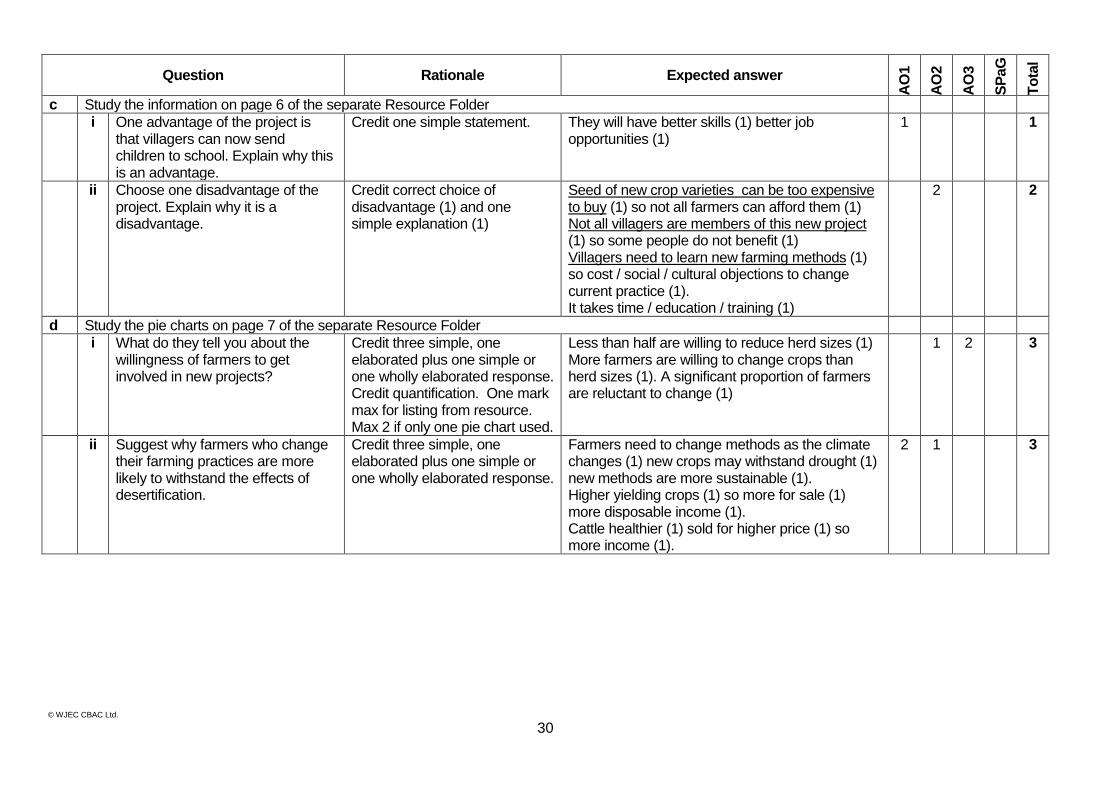
30
Question Rationale Expected answer
AO
1
AO
2
AO
3
SP
aG
To
tal
c Study the information on page 6 of the separate Resource Folder
i One advantage of the project is that villagers can now send children to school. Explain why this is an advantage.
Credit one simple statement.
They will have better skills (1) better job opportunities (1)
1 1
ii Choose one disadvantage of the project. Explain why it is a disadvantage.
Credit correct choice of disadvantage (1) and one simple explanation (1)
Seed of new crop varieties can be too expensive to buy (1) so not all farmers can afford them (1) Not all villagers are members of this new project (1) so some people do not benefit (1) Villagers need to learn new farming methods (1) so cost / social / cultural objections to change current practice (1). It takes time / education / training (1)
2 2
d Study the pie charts on page 7 of the separate Resource Folder
i What do they tell you about the willingness of farmers to get involved in new projects?
Credit three simple, one elaborated plus one simple or one wholly elaborated response. Credit quantification. One mark max for listing from resource. Max 2 if only one pie chart used.
Less than half are willing to reduce herd sizes (1) More farmers are willing to change crops than herd sizes (1). A significant proportion of farmers are reluctant to change (1)
1 2 3
ii Suggest why farmers who change their farming practices are more likely to withstand the effects of desertification.
Credit three simple, one elaborated plus one simple or one wholly elaborated response.
Farmers need to change methods as the climate changes (1) new crops may withstand drought (1) new methods are more sustainable (1). Higher yielding crops (1) so more for sale (1) more disposable income (1). Cattle healthier (1) sold for higher price (1) so more income (1).
2 1 3
© WJEC CBAC Ltd.
31
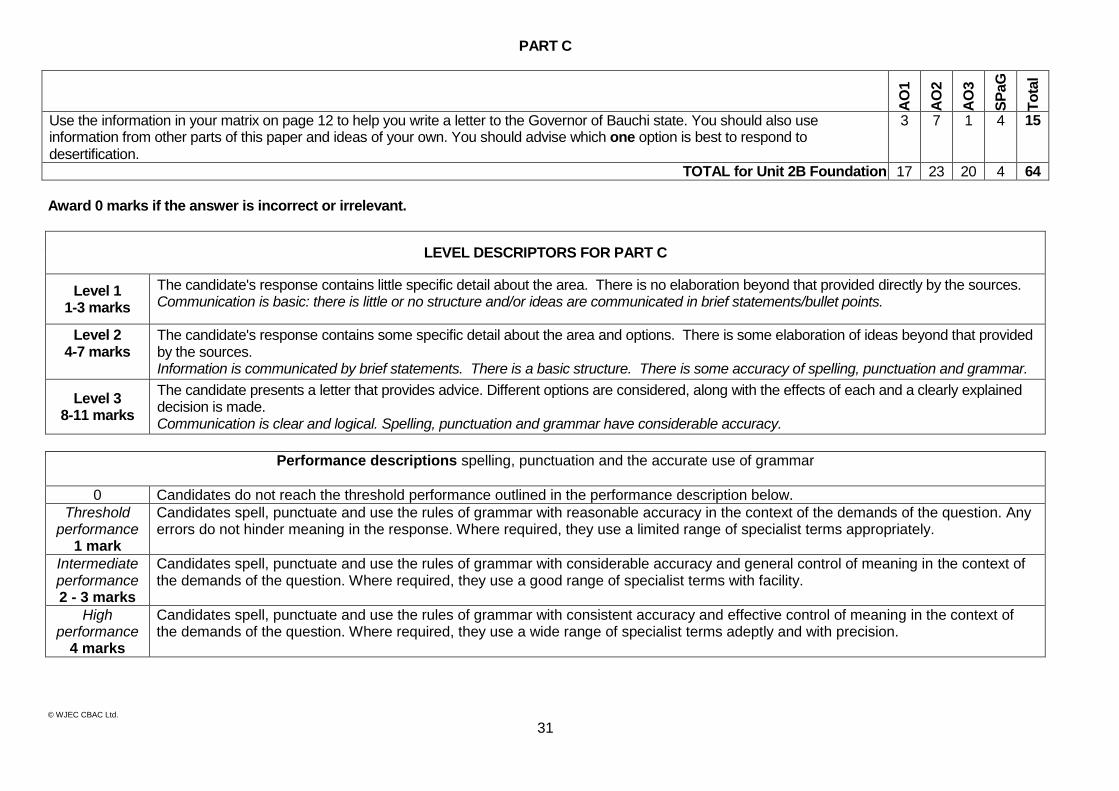
PART C
AO
1
AO
2
AO
3
SP
aG
To
tal
Use the information in your matrix on page 12 to help you write a letter to the Governor of Bauchi state. You should also use information from other parts of this paper and ideas of your own. You should advise which one option is best to respond to desertification.
3 7 1 4 15
TOTAL for Unit 2B Foundation 17 23 20 4 64
Award 0 marks if the answer is incorrect or irrelevant.
LEVEL DESCRIPTORS FOR PART C
Level 1 1-3 marks
The candidate's response contains little specific detail about the area. There is no elaboration beyond that provided directly by the sources. Communication is basic: there is little or no structure and/or ideas are communicated in brief statements/bullet points.
Level 2 4-7 marks
The candidate's response contains some specific detail about the area and options. There is some elaboration of ideas beyond that provided by the sources. Information is communicated by brief statements. There is a basic structure. There is some accuracy of spelling, punctuation and grammar.
Level 3 8-11 marks
The candidate presents a letter that provides advice. Different options are considered, along with the effects of each and a clearly explained decision is made. Communication is clear and logical. Spelling, punctuation and grammar have considerable accuracy.
Performance descriptions spelling, punctuation and the accurate use of grammar
0 Candidates do not reach the threshold performance outlined in the performance description below.
Threshold performance
1 mark
Candidates spell, punctuate and use the rules of grammar with reasonable accuracy in the context of the demands of the question. Any errors do not hinder meaning in the response. Where required, they use a limited range of specialist terms appropriately.
Intermediate performance 2 - 3 marks
Candidates spell, punctuate and use the rules of grammar with considerable accuracy and general control of meaning in the context of the demands of the question. Where required, they use a good range of specialist terms with facility.
High performance
4 marks
Candidates spell, punctuate and use the rules of grammar with consistent accuracy and effective control of meaning in the context of the demands of the question. Where required, they use a wide range of specialist terms adeptly and with precision.
© WJEC CBAC Ltd.
32
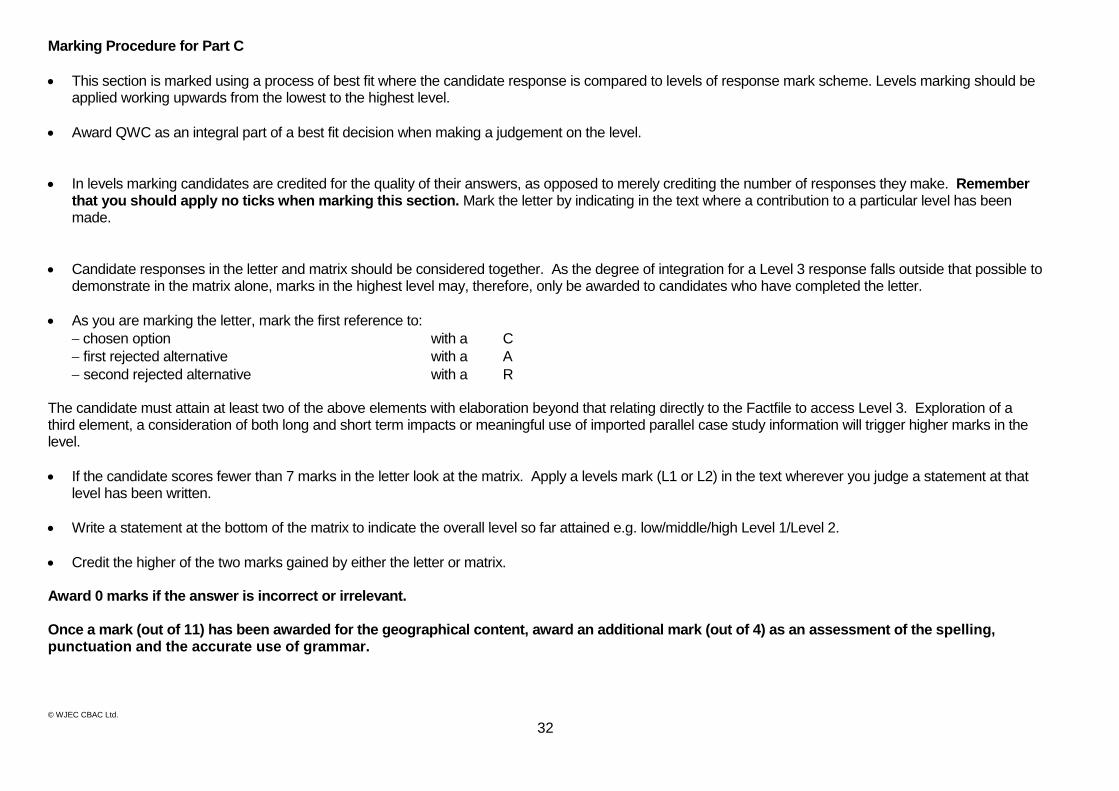
Marking Procedure for Part C
This section is marked using a process of best fit where the candidate response is compared to levels of response mark scheme. Levels marking should be applied working upwards from the lowest to the highest level.
Award QWC as an integral part of a best fit decision when making a judgement on the level.
In levels marking candidates are credited for the quality of their answers, as opposed to merely crediting the number of responses they make. Remember that you should apply no ticks when marking this section. Mark the letter by indicating in the text where a contribution to a particular level has been made.
Candidate responses in the letter and matrix should be considered together. As the degree of integration for a Level 3 response falls outside that possible to demonstrate in the matrix alone, marks in the highest level may, therefore, only be awarded to candidates who have completed the letter.
As you are marking the letter, mark the first reference to:
chosen option with a C
first rejected alternative with a A
second rejected alternative with a R The candidate must attain at least two of the above elements with elaboration beyond that relating directly to the Factfile to access Level 3. Exploration of a third element, a consideration of both long and short term impacts or meaningful use of imported parallel case study information will trigger higher marks in the level.
If the candidate scores fewer than 7 marks in the letter look at the matrix. Apply a levels mark (L1 or L2) in the text wherever you judge a statement at that level has been written.
Write a statement at the bottom of the matrix to indicate the overall level so far attained e.g. low/middle/high Level 1/Level 2.
Credit the higher of the two marks gained by either the letter or matrix. Award 0 marks if the answer is incorrect or irrelevant. Once a mark (out of 11) has been awarded for the geographical content, award an additional mark (out of 4) as an assessment of the spelling, punctuation and the accurate use of grammar.
© WJEC CBAC Ltd.
33
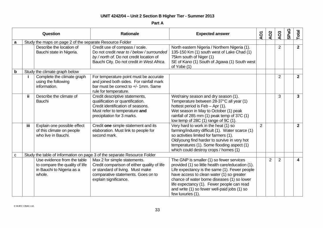
UNIT 4242/04 – Unit 2 Section B Higher Tier - Summer 2013
Part A
Question Rationale Expected answer
AO
1
AO
2
AO
3
SP
aG
To
tal
a Study the maps on page 2 of the separate Resource Folder
Describe the location of Bauchi state in Nigeria.
Credit use of compass / scale. Do not credit near to / below / surrounded by / north of. Do not credit location of Bauchi City. Do not credit in West Africa.
North eastern Nigeria / Northern Nigeria (1). 135-150 Km (1) south west of Lake Chad (1) 75km south of Niger (1) SE of Kano (1) South of Jigawa (1) South west of Yobe (1)
2 2
b Study the climate graph below
i Complete the climate graph using the following information.
For temperature point must be accurate and joined both sides. For rainfall mark bar must be correct to +/- 1mm. Same rule for temperature.
2 2
ii Describe the climate of Bauchi
Credit descriptive statements, qualification or quantification. Credit identification of seasons. Must refer to temperature and precipitation for 3 marks.
Wet/rainy season and dry season (1). Temperature between 28-37°C all year (1) hottest period is Feb – Apr (1). Wet season in May to October (1) peak rainfall of 285 mm (1) peak temp of 37C (1) low temp of 28C (1) range of 9C (1).
3 3
iii Explain one possible effect of this climate on people who live in Bauchi.
Credit one simple statement and its elaboration. Must link to people for second mark.
Very hard to work in the heat (1) so farming/industry difficult (1). Water scarce (1) so activities limited for farmers (1). Old/young find harder to survive in very hot temperatures (1). Some flooding aspect (1) which could destroy crops / homes (1)
2 2
c Study the table of information on page 3 of the separate Resource Folder
Use evidence from the table to compare the quality of life in Bauchi to Nigeria as a whole.
Max 2 for simple statements. Credit comparison of either quality of life or standard of living. Must make comparative statements. Goes on to explain significance.
The GNP is smaller (1) so fewer services provided (1) so little health care/education (1). Life expectancy is the same (1). Fewer people have access to clean water (1) so greater chance of water borne diseases (1) so lower life expectancy (1). Fewer people can read and write (1) so fewer well-paid jobs (1) so few luxuries (1).
2 2 4
© WJEC CBAC Ltd.
34
Question Rationale Expected answer
AO
1
AO
2
AO
3
SP
aG
To
tal
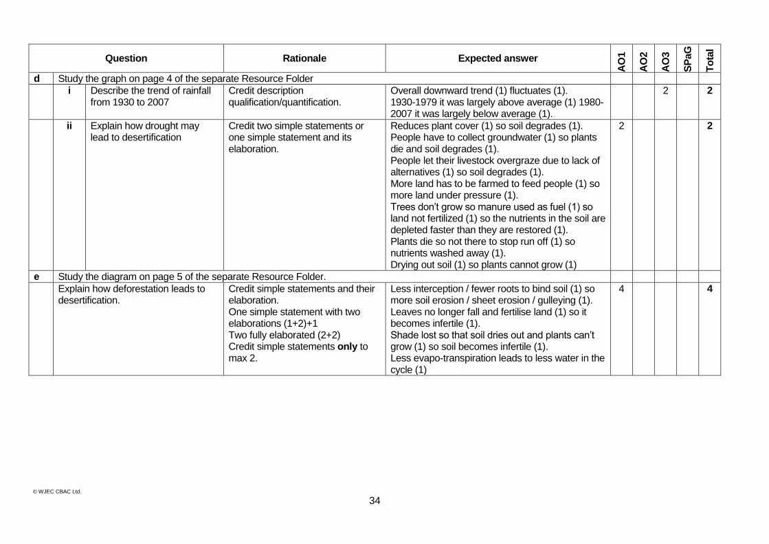
d Study the graph on page 4 of the separate Resource Folder
i Describe the trend of rainfall from 1930 to 2007
Credit description qualification/quantification.
Overall downward trend (1) fluctuates (1). 1930-1979 it was largely above average (1) 1980-2007 it was largely below average (1).
2 2
ii Explain how drought may lead to desertification
Credit two simple statements or one simple statement and its elaboration.
Reduces plant cover (1) so soil degrades (1). People have to collect groundwater (1) so plants die and soil degrades (1). People let their livestock overgraze due to lack of alternatives (1) so soil degrades (1). More land has to be farmed to feed people (1) so more land under pressure (1). Trees don’t grow so manure used as fuel (1) so land not fertilized (1) so the nutrients in the soil are depleted faster than they are restored (1). Plants die so not there to stop run off (1) so nutrients washed away (1). Drying out soil (1) so plants cannot grow (1)
2 2
e Study the diagram on page 5 of the separate Resource Folder.
Explain how deforestation leads to desertification.
Credit simple statements and their elaboration. One simple statement with two elaborations (1+2)+1 Two fully elaborated (2+2) Credit simple statements only to max 2.
Less interception / fewer roots to bind soil (1) so more soil erosion / sheet erosion / gulleying (1). Leaves no longer fall and fertilise land (1) so it becomes infertile (1). Shade lost so that soil dries out and plants can’t grow (1) so soil becomes infertile (1). Less evapo-transpiration leads to less water in the cycle (1)
4 4

© WJEC CBAC Ltd.
35
Question Rationale Expected answer
AO
1
AO
2
AO
3
SP
aG
To
tal
f Study the diagram on page 6 of the separate Resource Folder
i Choose two of these methods and explain how each may contribute to desertification
No credit for choosing method. One mark for each explanation.
Overgrazing reduces vegetation so soil blows away (1). Over cropping removes nutrients from soil (1). Lack of fertiliser means that soil loses fertility (1). Monoculture removes some nutrients from the soil (1). Not allowing land to rest so land loses fertility (1). Ploughing up and down leads to gulley erosion (1). Land clearance exposes land to erosion by wind and rain (1). Irrigation can salinize soil (1). Taking too much ground water means plants die and erosion ensues (1).
2 2
ii Suggest why farmers continue to use these poor farming methods even though they risk desertification.
Credit two simple statements or one simple statement with elaboration.
Lack of income / savings (1) to invest in new technologies (1). Lack of training / skills (1) to learn new techniques (1). Religious / cultural traditions (1) so reluctance to change (1). Cheaper (1). Only option (1)
2 2
© WJEC CBAC Ltd.
36
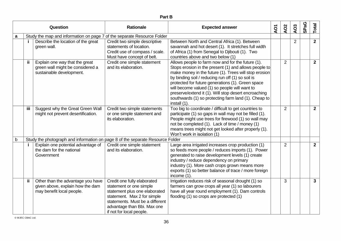
Part B
Question Rationale Expected answer
AO
1
AO
2
AO
3
SP
aG
To
tal
a Study the map and information on page 7 of the separate Resource Folder
i Describe the location of the great green wall.
Credit two simple descriptive statements of location. Credit use of compass / scale. Must have concept of belt.
Between North and Central Africa (1). Between savannah and hot desert (1). It stretches full width of Africa (1) from Senegal to Djibouti (1). Two countries above and two below (1)
2 2
ii Explain one way that the great green wall might be considered a sustainable development.
Credit one simple statement and its elaboration.
Allows people to farm now and for the future (1). Stops erosion in the present (1) and allows people to make money in the future (1). Trees will stop erosion by binding soil / reducing run off (1) so soil is protected for future generations (1). Green space will become valued (1) so people will want to preserve/extend it (1). Will stop desert encroaching southwards (1) so protecting farm land (1). Cheap to install (1).
2 2
iii Suggest why the Great Green Wall might not prevent desertification.
Credit two simple statements or one simple statement and its elaboration.
Too big to coordinate / difficult to get countries to participate (1) so gaps in wall may not be filled (1). People might use trees for firewood (1) so wall may not be completed (1). Lack of time / money (1) means trees might not get looked after properly (1). Won’t work in isolation (1)
2 2
b Study the photograph and information on page 8 of the separate Resource Folder
i Explain one potential advantage of the dam for the national Government
Credit one simple statement and its elaboration.
Large area irrigated increases crop production (1) so feeds more people / reduces imports (1). Power generated to raise development levels (1) create industry / reduce dependency on primary industry (1). More cash crops grown means more exports (1) so better balance of trace / more foreign income (1).
2 2
ii Other than the advantage you have given above, explain how the dam may benefit local people.
Credit one fully elaborated statement or one simple statement plus one elaborated statement. Max 2 for simple statements. Must be a different advantage than Bbi. Max one if not for local people.
Irrigation reduces risk of seasonal drought (1) so farmers can grow crops all year (1) so labourers have all year round employment (1). Dam controls flooding (1) so crops are protected (1)
3 3
© WJEC CBAC Ltd.
37
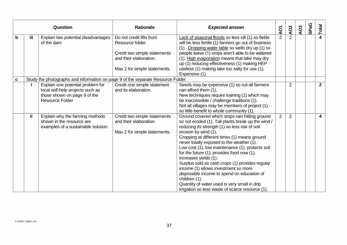
Question Rationale Expected answer
AO
1
AO
2
AO
3
SP
aG
To
tal
b iii Explain two potential disadvantages of the dam
Do not credit lifts from Resource folder. Credit two simple statements and their elaboration. Max 2 for simple statements.
Lack of seasonal floods so less silt (1) so fields will be less fertile (1) farmers go out of business (1). Dropping water table so wells dry up (1) so people leave (1) crops aren’t able to be watered (1). High evaporation means that lake may dry up (1) reducing effectiveness (1) making HEP useless (1) making lake too salty for use (1). Expensive (1)
2 2 4
c Study the photographs and information on page 9 of the separate Resource Folder
i Explain one potential problem for local self-help projects such as those shown on page 9 of the Resource Folder
Credit one simple statement and its elaboration.
Seeds may be expensive (1) so not all farmers can afford them (1). New techniques require training (1) which may be inaccessible / challenge traditions (1). Not all villages may be members of project (1) so little benefit to whole community (1).
2 2
ii Explain why the farming methods shown in the resource are examples of a sustainable solution.
Credit two simple statements and their elaboration. Max 2 for simple statements.
Ground covered which stops rain hitting ground so not eroded (1). Tall plants break up the wind / reducing its strength (1) so less risk of soil erosion by wind (1). Cropping at different times (1) means ground never totally exposed to the weather (1). Low cost (1), low maintenance (1), protects soil for the future (1), provides food now (1), increases yields (1). Surplus sold as cash crops (1) provides regular income (1) allows investment so more disposable income to spend on education of children (1). Quantity of water used is very small in drip irrigation so less waste of scarce resource (1).
2 2 4
© WJEC CBAC Ltd.
38
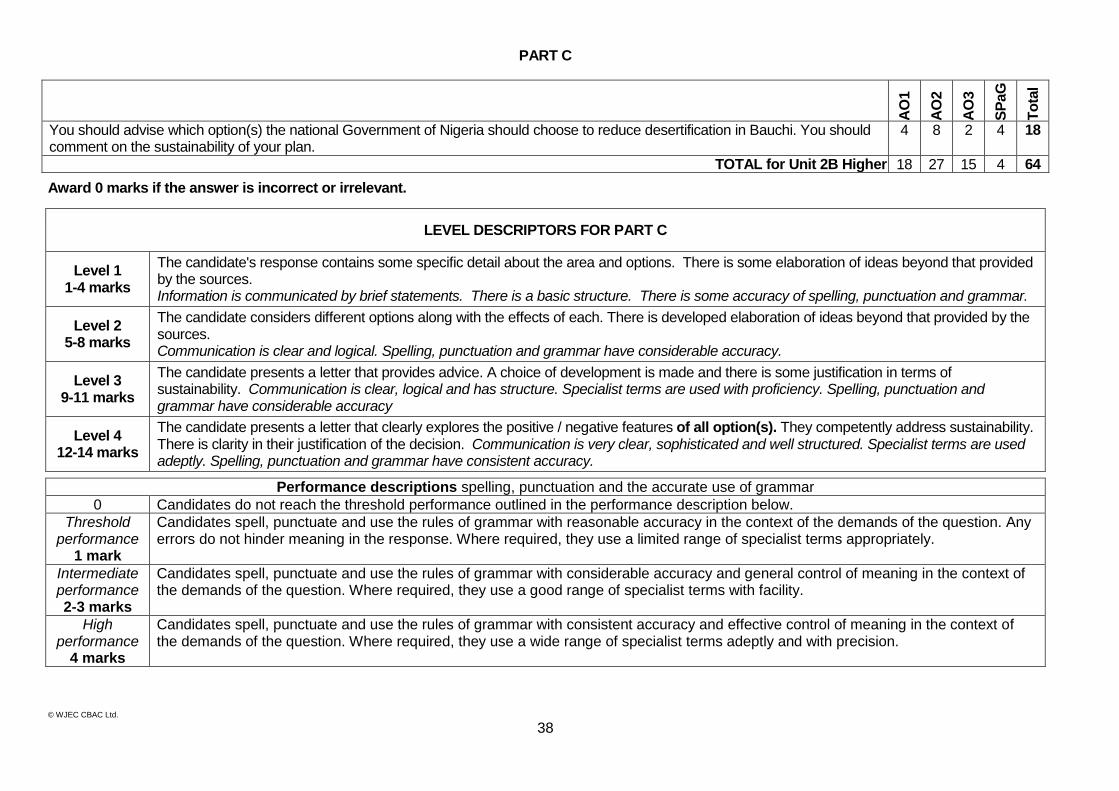
PART C
AO
1
AO
2
AO
3
SP
aG
To
tal
You should advise which option(s) the national Government of Nigeria should choose to reduce desertification in Bauchi. You should comment on the sustainability of your plan.
4 8 2 4 18
TOTAL for Unit 2B Higher 18 27 15 4 64
Award 0 marks if the answer is incorrect or irrelevant.
LEVEL DESCRIPTORS FOR PART C
Level 1 1-4 marks
The candidate's response contains some specific detail about the area and options. There is some elaboration of ideas beyond that provided by the sources. Information is communicated by brief statements. There is a basic structure. There is some accuracy of spelling, punctuation and grammar.
Level 2 5-8 marks
The candidate considers different options along with the effects of each. There is developed elaboration of ideas beyond that provided by the sources. Communication is clear and logical. Spelling, punctuation and grammar have considerable accuracy.
Level 3 9-11 marks
The candidate presents a letter that provides advice. A choice of development is made and there is some justification in terms of sustainability. Communication is clear, logical and has structure. Specialist terms are used with proficiency. Spelling, punctuation and grammar have considerable accuracy
Level 4 12-14 marks
The candidate presents a letter that clearly explores the positive / negative features of all option(s). They competently address sustainability. There is clarity in their justification of the decision. Communication is very clear, sophisticated and well structured. Specialist terms are used adeptly. Spelling, punctuation and grammar have consistent accuracy.
Performance descriptions spelling, punctuation and the accurate use of grammar
0 Candidates do not reach the threshold performance outlined in the performance description below.
Threshold performance
1 mark
Candidates spell, punctuate and use the rules of grammar with reasonable accuracy in the context of the demands of the question. Any errors do not hinder meaning in the response. Where required, they use a limited range of specialist terms appropriately.
Intermediate performance 2-3 marks
Candidates spell, punctuate and use the rules of grammar with considerable accuracy and general control of meaning in the context of the demands of the question. Where required, they use a good range of specialist terms with facility.
High performance
4 marks
Candidates spell, punctuate and use the rules of grammar with consistent accuracy and effective control of meaning in the context of the demands of the question. Where required, they use a wide range of specialist terms adeptly and with precision.
© WJEC CBAC Ltd.
39
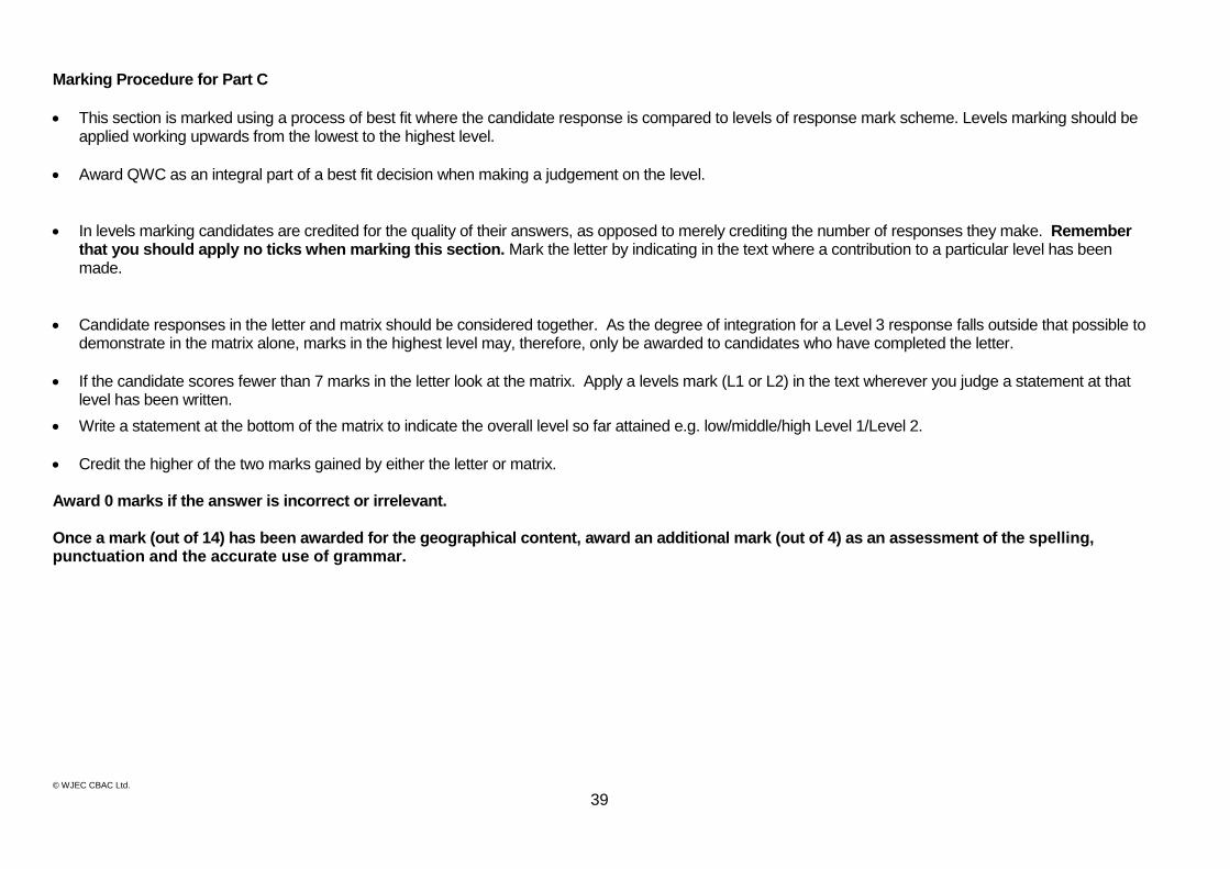
Marking Procedure for Part C
This section is marked using a process of best fit where the candidate response is compared to levels of response mark scheme. Levels marking should be applied working upwards from the lowest to the highest level.
Award QWC as an integral part of a best fit decision when making a judgement on the level.
In levels marking candidates are credited for the quality of their answers, as opposed to merely crediting the number of responses they make. Remember that you should apply no ticks when marking this section. Mark the letter by indicating in the text where a contribution to a particular level has been made.
Candidate responses in the letter and matrix should be considered together. As the degree of integration for a Level 3 response falls outside that possible to demonstrate in the matrix alone, marks in the highest level may, therefore, only be awarded to candidates who have completed the letter.
If the candidate scores fewer than 7 marks in the letter look at the matrix. Apply a levels mark (L1 or L2) in the text wherever you judge a statement at that level has been written.
Write a statement at the bottom of the matrix to indicate the overall level so far attained e.g. low/middle/high Level 1/Level 2.
Credit the higher of the two marks gained by either the letter or matrix. Award 0 marks if the answer is incorrect or irrelevant. Once a mark (out of 14) has been awarded for the geographical content, award an additional mark (out of 4) as an assessment of the spelling, punctuation and the accurate use of grammar.

© WJEC CBAC Ltd.
WJEC 245 Western Avenue Cardiff CF5 2YX Tel No 029 2026 5000 Fax 029 2057 5994 E-mail: [email protected] website: www.wjec.co.uk