Embed Size (px)
Citation preview
River and coasts ‐ need to know• Processes within a river basin• River flooding and management• River landforms• Coastal landforms• Coastal management
1
GCSE Geography Revision Pack: Key Themes PaperRiver and coasts
NAME:
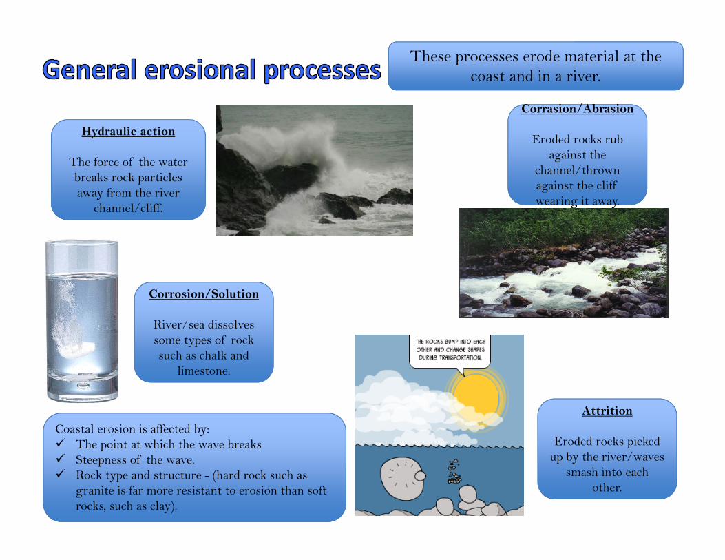
These processes erode material at the coast and in a river.
Hydraulic action
The force of the water breaks rock particles away from the river
channel/cliff.
Corrasion/Abrasion
wearing it away.
Corrasion/Abrasion
Eroded rocks rub against the
channel/thrown against the cliff wearing it away.
Attrition
Eroded rocks picked up by the river/waves
smash into each other.
Corrosion/Solution
River/sea dissolves some types of rock such as chalk and
limestone.
Coastal erosion is affected by: The point at which the wave breaks Steepness of the wave. Rock type and structure - (hard rock such as
granite is far more resistant to erosion than soft rocks, such as clay).
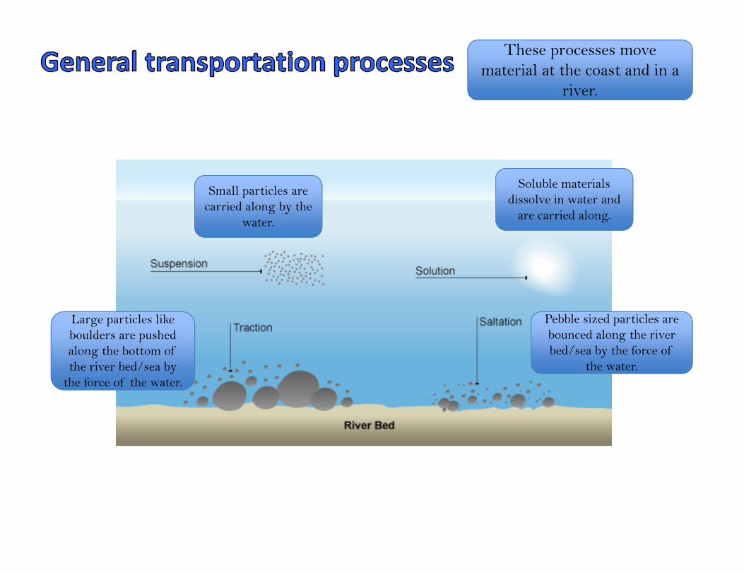
These processes move material at the coast and in a
river.
Small particles are carried along by the
water.
Large particles like boulders are pushed along the bottom of the river bed/sea by
the force of the water.
Soluble materials dissolve in water and
are carried along.
Pebble sized particles are bounced along the river bed/sea by the force of
the water.
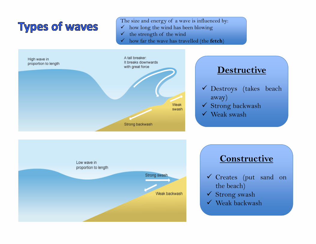
Destructive
Destroys (takes beachaway)
Strong backwash Weak swash
Constructive
Creates (put sand onthe beach)
Strong swash Weak backwash
The size and energy of a wave is influenced by: how long the wind has been blowing the strength of the wind how far the wave has travelled (the fetch)
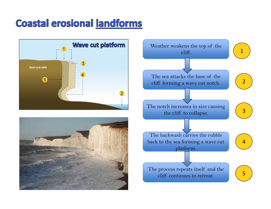
Weather weakens the top of the cliff.
The sea attacks the base of the cliff forming a wave cut notch.
The notch increases in size causing the cliff to collapse.
The backwash carries the rubble back to the sea forming a wave cut
platform.
The process repeats itself and the cliff continues to retreat.
1
2
3
4
5
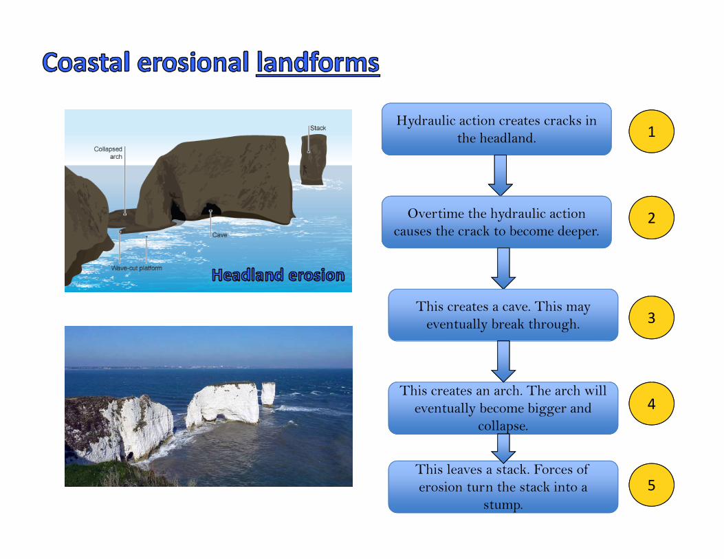
Hydraulic action creates cracks in the headland.
Overtime the hydraulic action causes the crack to become deeper.
This creates a cave. This may eventually break through.
This creates an arch. The arch will eventually become bigger and
collapse.
This leaves a stack. Forces of erosion turn the stack into a
stump.
1
2
3
4
5

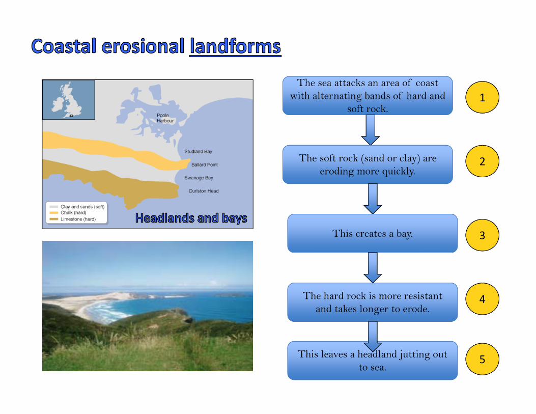
The sea attacks an area of coast with alternating bands of hard and
soft rock.
The soft rock (sand or clay) are eroding more quickly.
This creates a bay.
The hard rock is more resistant and takes longer to erode.
This leaves a headland jutting out to sea.
1
2
3
4
5
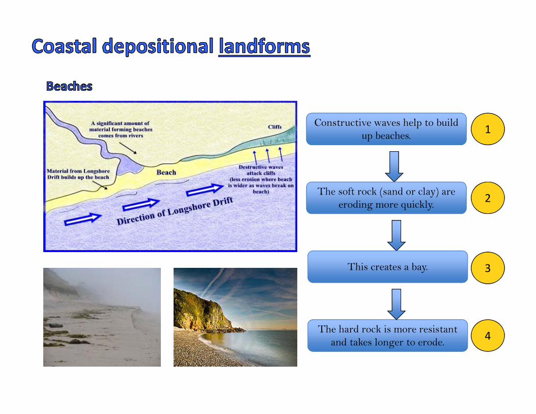
Constructive waves help to build up beaches.
The soft rock (sand or clay) are eroding more quickly.
This creates a bay.
The hard rock is more resistant and takes longer to erode.
1
2
3
4
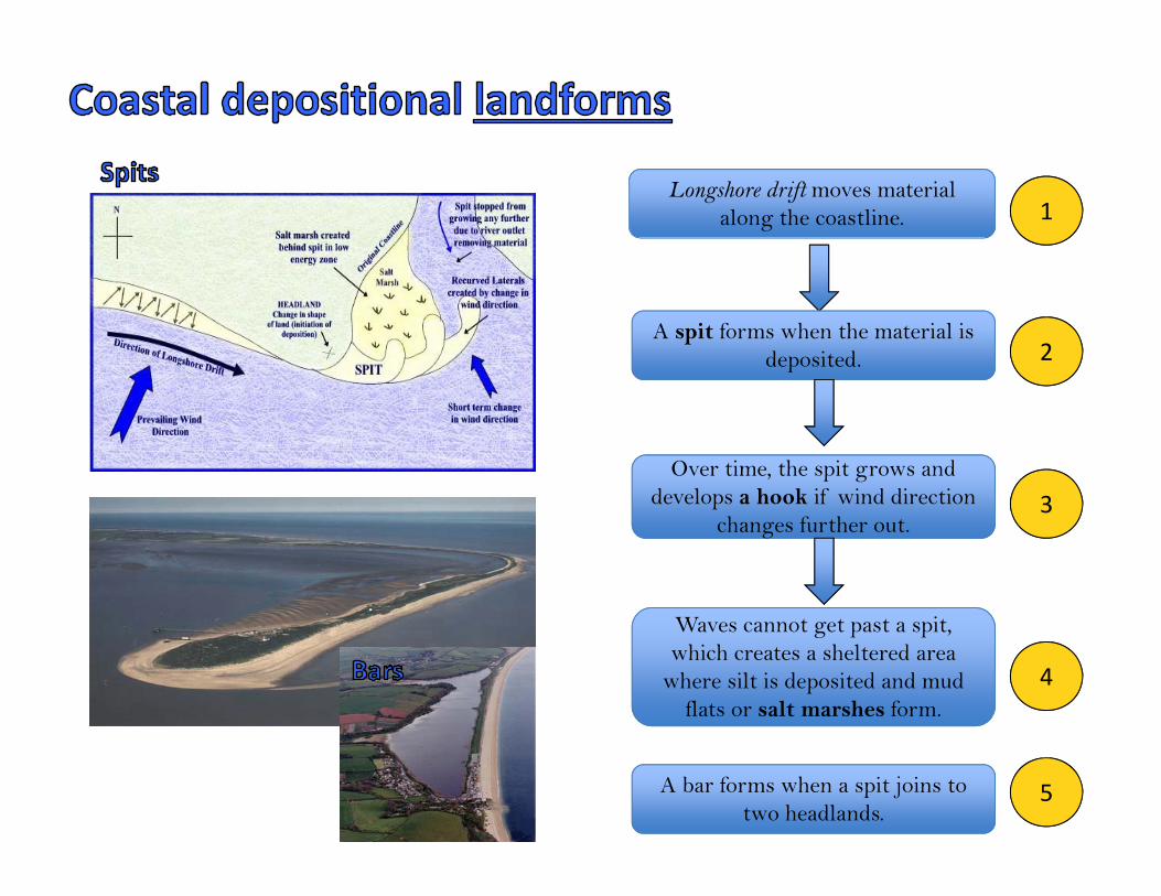
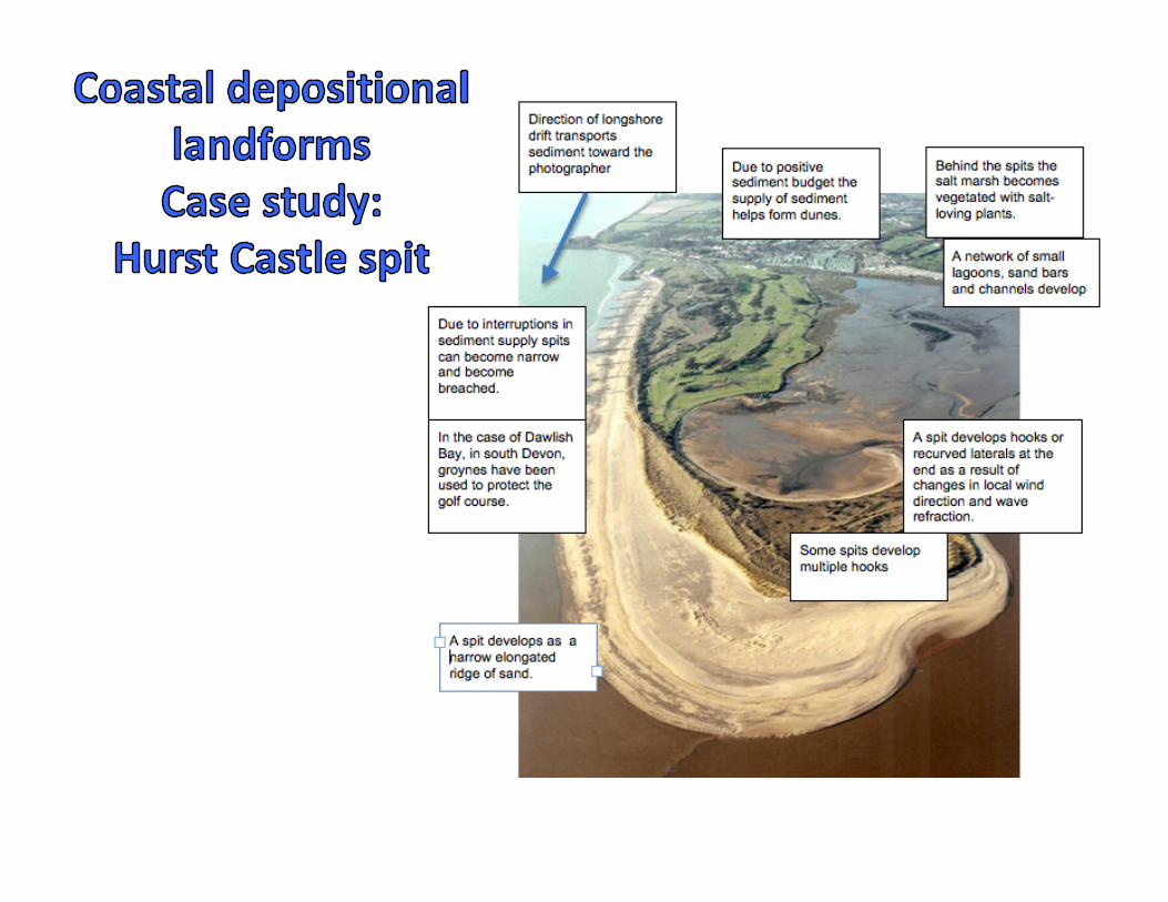
Longshore drift moves material along the coastline.
A spit forms when the material is deposited.
g
Over time, the spit grows and develops a hook if wind direction
changes further out.
Waves cannot get past a spit, which creates a sheltered area
where silt is deposited and mud flats or salt marshes form.
1
2
3
4
A bar forms when a spit joins to two headlands.
5
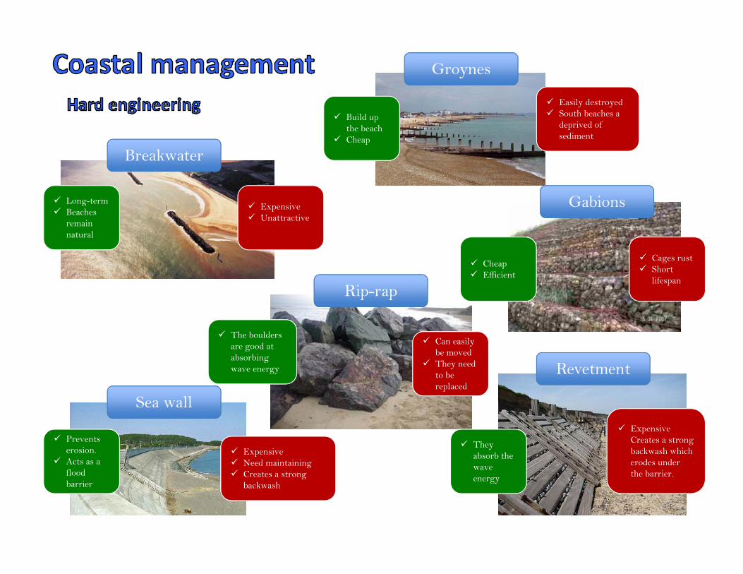
Rip-rap
Breakwater
Groynes
Gabions
Sea wall
Revetment
Expensive Unattractive
Long-term Beaches
remain natural
Easily destroyed South beaches a
deprived of sediment
Build up the beach
Cheap
The boulders are good at absorbing wave energy
Prevents erosion.
Acts as a flood barrier
Expensive Need maintaining Creates a strong
backwash
Can easily be moved
They need to be replaced
Cheap Efficient
Cages rust Short
lifespan
Expensive Creates a strong backwash which erodes under the barrier.
They absorb the wave energy
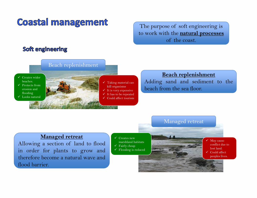
Beach replenishment
Creates wider beaches.
Protects from erosion and flooding
Looks natural
Taking material can kill organisms
It is very expensive It has to be repeated Could affect tourism
Managed retreat
Creates new marshland habitats
Fairly cheap Flooding is reduced
May cause conflict due to lost land.
Could affect peoples lives.
The purpose of soft engineering is to work with the natural processes
of the coast.
Beach replenishmentAdding sand and sediment to thebeach from the sea floor.
Managed retreatAllowing a section of land to floodin order for plants to grow andtherefore become a natural wave andflood barrier.
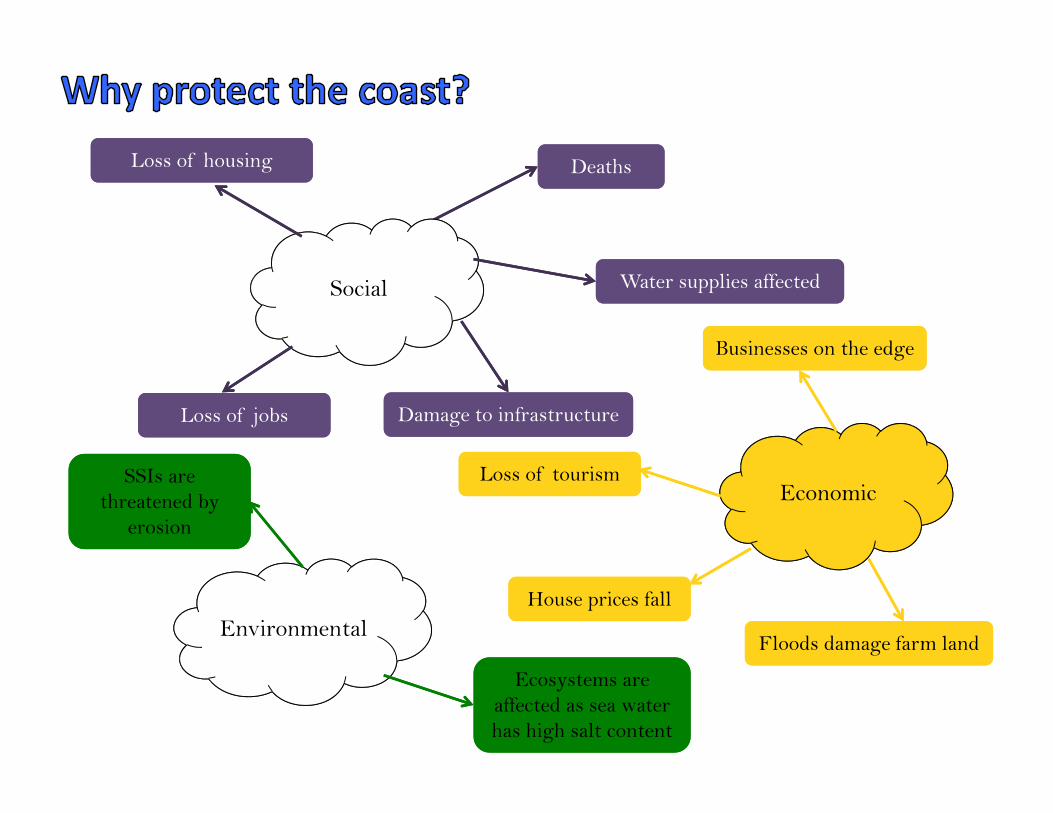
Social
Economic
Environmental
DeathsDeaths
Water supplies affectedWater supplies affected
Loss of housingLoss of housing
Loss of jobsLoss of jobs Damage to infrastructureDamage to infrastructure
Loss of tourismLoss of tourism
Floods damage farm landFloods damage farm land
Businesses on the edgeBusinesses on the edge
House prices fallHouse prices fall
SSIs are threatened by
erosion
SSIs are threatened by
erosion
Ecosystems are affected as sea water has high salt content
Ecosystems are affected as sea water has high salt content
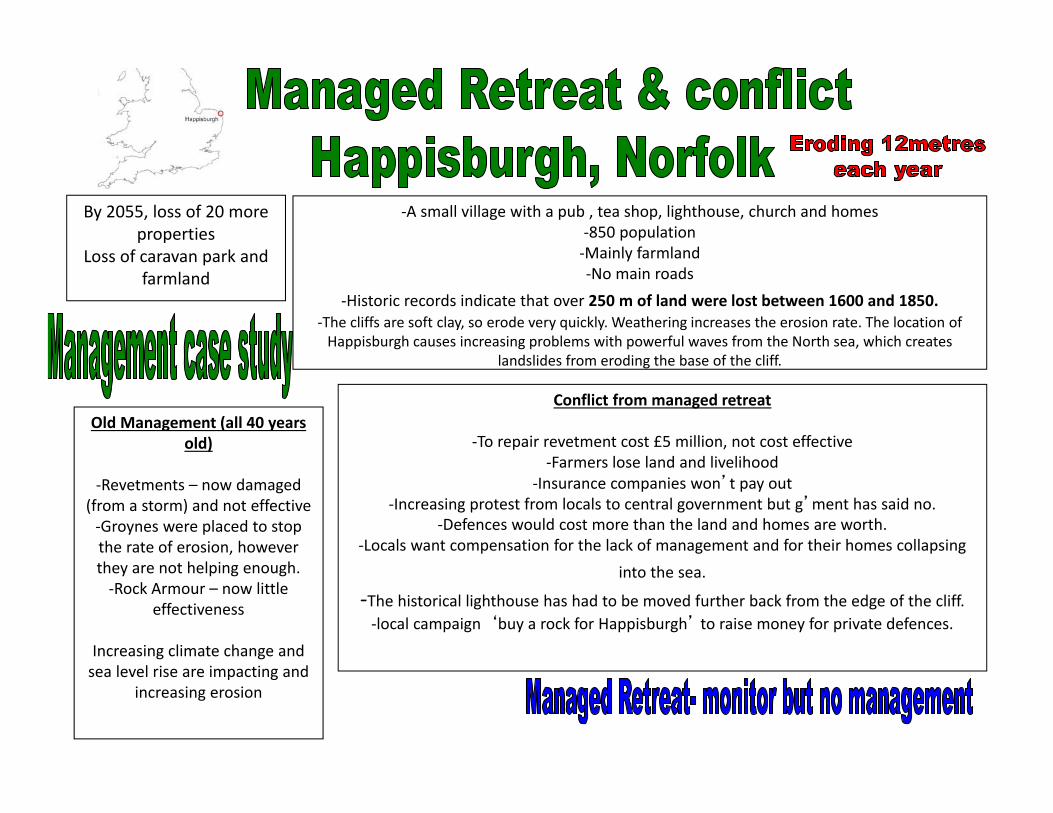
Old Management (all 40 years old)
‐Revetments – now damaged (from a storm) and not effective‐Groynes were placed to stop the rate of erosion, however they are not helping enough.‐Rock Armour – now little
effectiveness
Increasing climate change and sea level rise are impacting and
increasing erosion
Conflict from managed retreat
‐To repair revetment cost £5 million, not cost effective‐Farmers lose land and livelihood
‐Insurance companies won’t pay out ‐Increasing protest from locals to central government but g’ment has said no.
‐Defences would cost more than the land and homes are worth. ‐Locals want compensation for the lack of management and for their homes collapsing
into the sea.
‐The historical lighthouse has had to be moved further back from the edge of the cliff. ‐local campaign ‘buy a rock for Happisburgh’ to raise money for private defences.
‐A small village with a pub , tea shop, lighthouse, church and homes ‐850 population ‐Mainly farmland‐No main roads
‐Historic records indicate that over 250 m of land were lost between 1600 and 1850.‐The cliffs are soft clay, so erode very quickly. Weathering increases the erosion rate. The location of Happisburgh causes increasing problems with powerful waves from the North sea, which creates
landslides from eroding the base of the cliff.
By 2055, loss of 20 more properties
Loss of caravan park and farmland
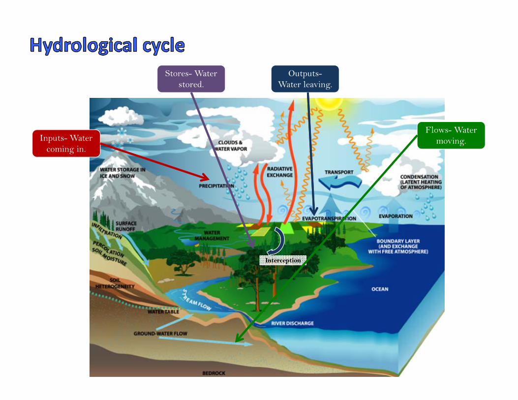
Flows- Water moving.
Stores- Water stored.
Inputs- Water coming in.
Outputs-Water leaving.
InterceptionInterception
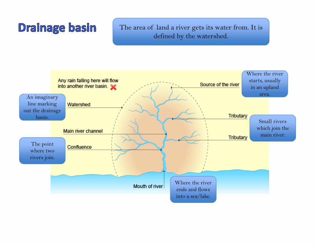
The area of land a river gets its water from. It is defined by the watershed.
An imaginary line marking
out the drainage basin.
The point where two rivers join.
Where the river ends and flows into a sea/lake.
Small rivers which join the
main river.
Where the river Where the river starts, usually in an upland
area.
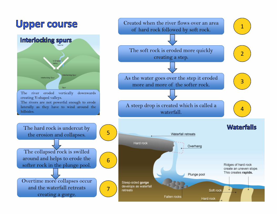
Created when the river flows over an area of hard rock followed by soft rock.
The soft rock is eroded more quickly creating a step.
As the water goes over the step it eroded more and more of the softer rock.
A steep drop is created which is called a waterfall.
1
2
3
4
The hard rock is undercut by the erosion and collapses.
The collapsed rock is swilled around and helps to erode the softer rock in the plunge pool.
g g g
Overtime more collapses occur and the waterfall retreats
creating a gorge.
5
6
7
The river eroded vertically downwardscreating V-shaped valleys.The rivers are not powerful enough to erodelaterally as they have to wind around thehillsides.
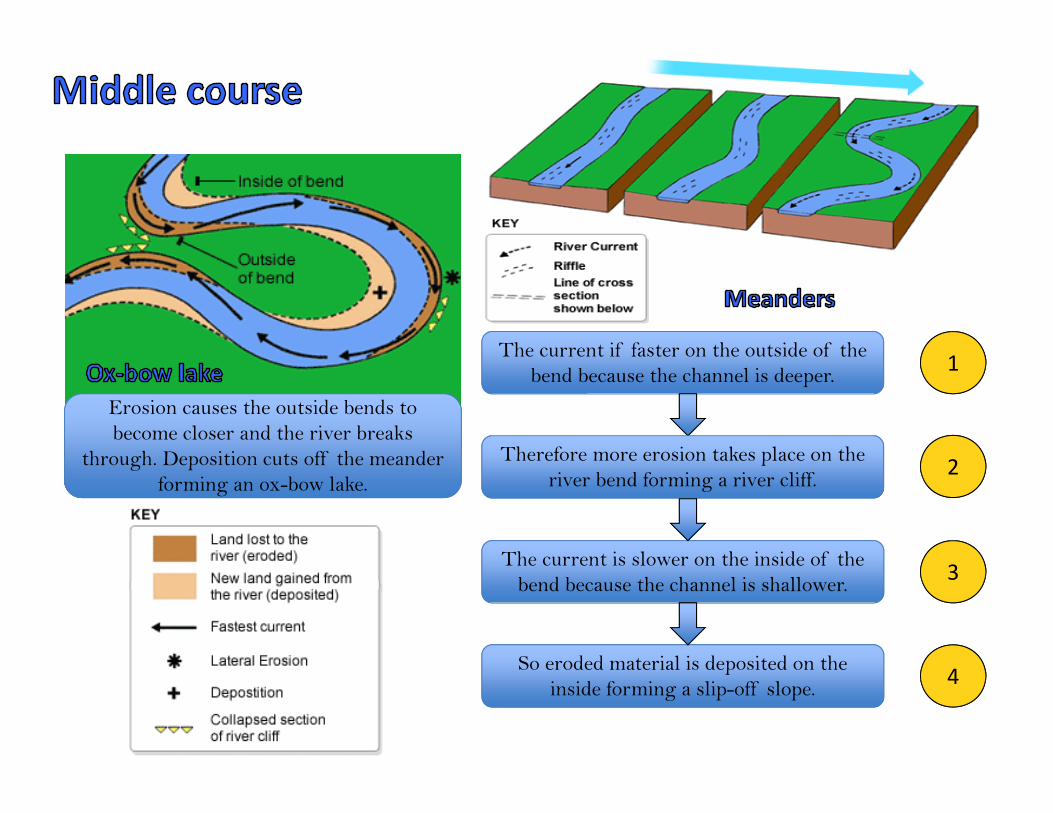
The current if faster on the outside of the bend because the channel is deeper.
Therefore more erosion takes place on the river bend forming a river cliff.
The current is slower on the inside of the bend because the channel is shallower.
So eroded material is deposited on the inside forming a slip-off slope.
1
2
3
4
Erosion causes the outside bends to become closer and the river breaks
through. Deposition cuts off the meander forming an ox-bow lake.
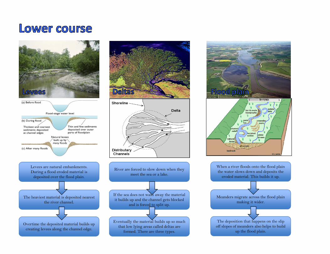
Levees are natural embankments. During a flood eroded material is
deposited over the flood plain.
The heaviest material is deposited nearest the river channel.
Overtime the deposited material builds up creating levees along the channel edge.
River are forced to slow down when they meet the sea or a lake.
If the sea does not wash away the material it builds up and the channel gets blocked
and is forced to split up.
Eventually the material builds up so much that low lying areas called deltas are
formed. There are three types.
When a river floods onto the flood plain the water slows down and deposits the
eroded material. This builds it up.
Meanders migrate across the flood plain making it wider.
The deposition that happens on the slip off slopes of meanders also helps to build
up the flood plain.
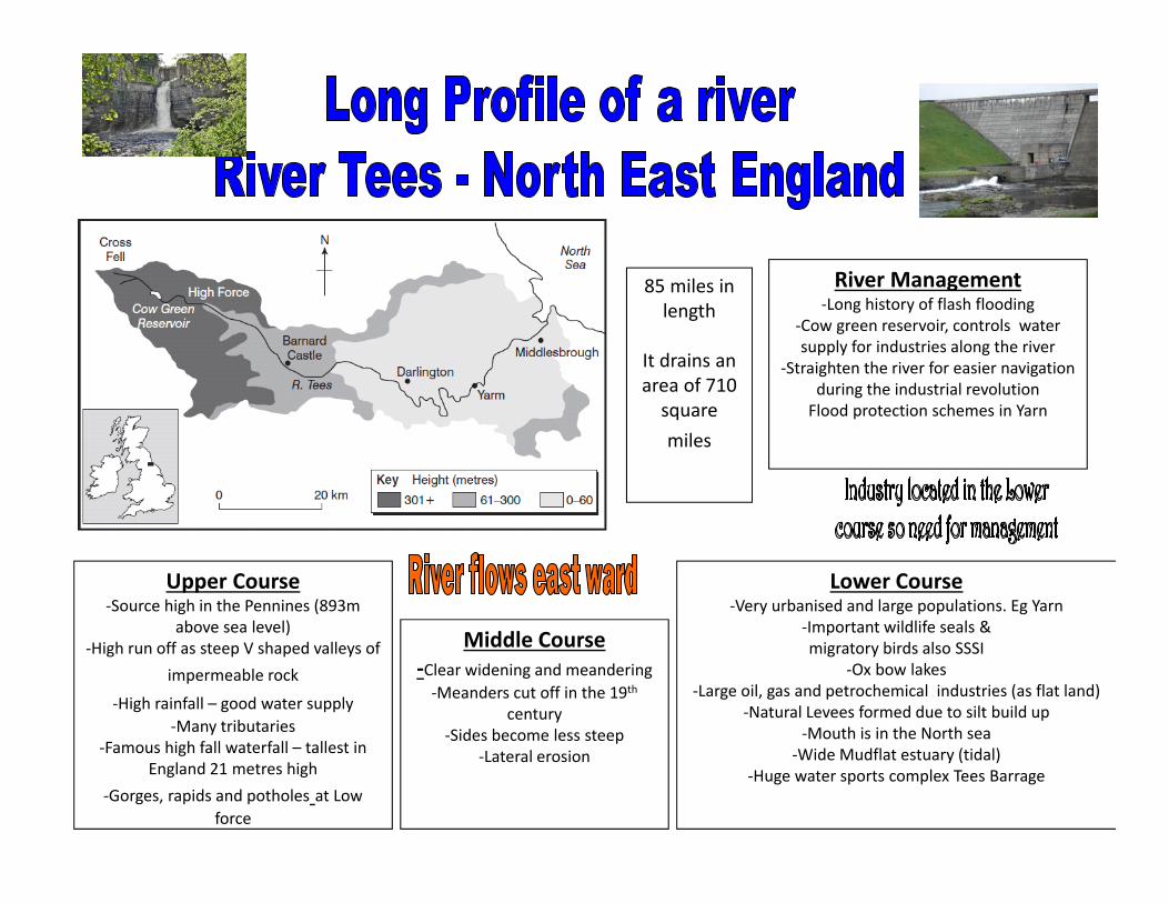
Upper Course‐Source high in the Pennines (893m
above sea level)‐High run off as steep V shaped valleys of
impermeable rock
‐High rainfall – good water supply‐Many tributaries
‐Famous high fall waterfall – tallest in England 21 metres high
‐Gorges, rapids and potholes at Low force
Middle Course‐Clear widening and meandering ‐Meanders cut off in the 19th
century‐Sides become less steep
‐Lateral erosion
Lower Course‐Very urbanised and large populations. Eg Yarn
‐Important wildlife seals & migratory birds also SSSI
‐Ox bow lakes ‐Large oil, gas and petrochemical industries (as flat land)
‐Natural Levees formed due to silt build up ‐Mouth is in the North sea
‐Wide Mudflat estuary (tidal)‐Huge water sports complex Tees Barrage
River Management‐Long history of flash flooding
‐Cow green reservoir, controls water supply for industries along the river
‐Straighten the river for easier navigation during the industrial revolution Flood protection schemes in Yarn
85 miles in length
It drains an area of 710 square miles
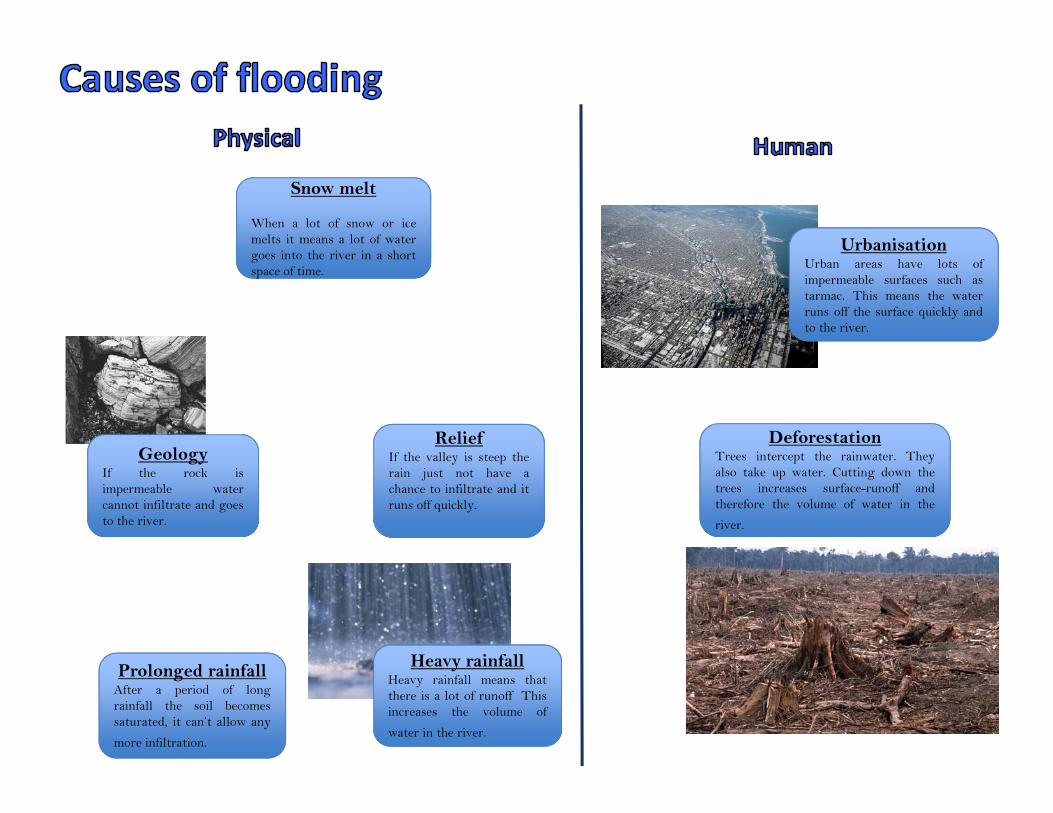
UrbanisationUrban areas have lots ofimpermeable surfaces such astarmac. This means the waterruns off the surface quickly andto the river.
DeforestationTrees intercept the rainwater. Theyalso take up water. Cutting down thetrees increases surface-runoff andtherefore the volume of water in the
river.
GeologyIf the rock isimpermeable watercannot infiltrate and goesto the river.
ReliefIf the valley is steep therain just not have achance to infiltrate and itruns off quickly.
Heavy rainfallHeavy rainfall means thatthere is a lot of runoff Thisincreases the volume of
water in the river.
Prolonged rainfallAfter a period of longrainfall the soil becomessaturated, it can’t allow any
more infiltration.
space
Snow melt
When a lot of snow or icemelts it means a lot of watergoes into the river in a shortspace of time.
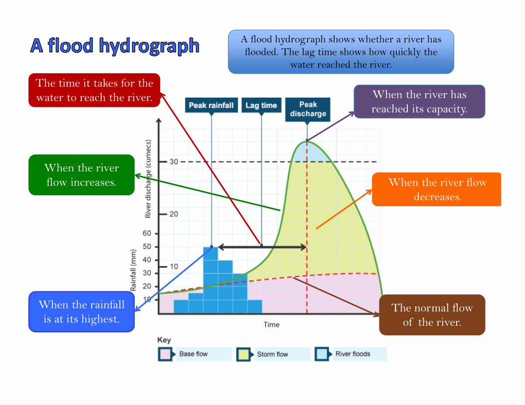
A flood hydrograph shows whether a river has flooded. The lag time shows how quickly the
water reached the river.
When the river has reached its capacity.
When the river flow decreases.
When the river flow increases.
The time it takes for the water to reach the river.
When the rainfall is at its highest.
The normal flow of the river.
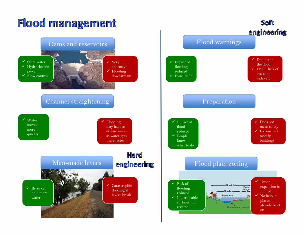
Dams and reservoirs
Very expensive
Flooding downstream
Store water Hydroelectric
power Flow control
Channel straightening
Man-made levees
Flood warnings
Preparation
Flood plain zoning
Flooding may happen downstream as water gets there faster
Water moves more quickly
Catastrophic flooding if levees break
River can hold more water
Don’t stop the flood
LEDC lack of access to radio etc
Urban expansion is limited
No help in places already built on
Does not mean safety
Expensive to modify buildings
Risk of flooding reduced
Impermeable surfaces not created
Impact of flood reduced
People know what to do
Impact of flooding reduced
Evacuation
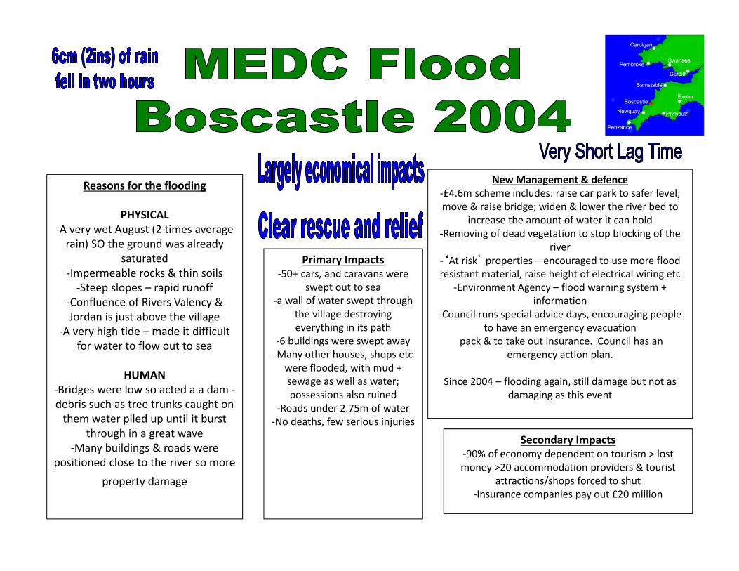
Reasons for the flooding
PHYSICAL ‐A very wet August (2 times average rain) SO the ground was already
saturated ‐Impermeable rocks & thin soils ‐Steep slopes – rapid runoff
‐Confluence of Rivers Valency & Jordan is just above the village
‐A very high tide – made it difficult for water to flow out to sea
HUMAN ‐Bridges were low so acted a a dam ‐debris such as tree trunks caught on them water piled up until it burst
through in a great wave ‐Many buildings & roads were
positioned close to the river so more property damage
Primary Impacts ‐50+ cars, and caravans were
swept out to sea‐a wall of water swept through
the village destroying everything in its path
‐6 buildings were swept away ‐Many other houses, shops etc were flooded, with mud + sewage as well as water; possessions also ruined
‐Roads under 2.75m of water‐No deaths, few serious injuries
Secondary Impacts ‐90% of economy dependent on tourism > lost money >20 accommodation providers & tourist
attractions/shops forced to shut ‐Insurance companies pay out £20 million
New Management & defence ‐£4.6m scheme includes: raise car park to safer level; move & raise bridge; widen & lower the river bed to
increase the amount of water it can hold‐Removing of dead vegetation to stop blocking of the
river ‐‘At risk’ properties – encouraged to use more flood resistant material, raise height of electrical wiring etc
‐Environment Agency – flood warning system + information
‐Council runs special advice days, encouraging people to have an emergency evacuation
pack & to take out insurance. Council has an emergency action plan.
Since 2004 – flooding again, still damage but not as damaging as this event
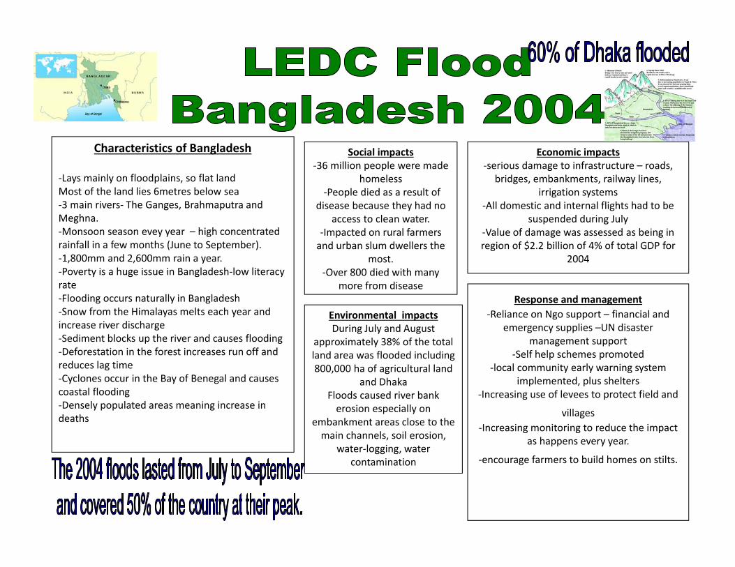
Characteristics of Bangladesh
‐Lays mainly on floodplains, so flat landMost of the land lies 6metres below sea‐3 main rivers‐ The Ganges, Brahmaputra and Meghna. ‐Monsoon season evey year – high concentrated rainfall in a few months (June to September).‐1,800mm and 2,600mm rain a year. ‐Poverty is a huge issue in Bangladesh‐low literacy rate‐Flooding occurs naturally in Bangladesh ‐Snow from the Himalayas melts each year and increase river discharge ‐Sediment blocks up the river and causes flooding ‐Deforestation in the forest increases run off and reduces lag time‐Cyclones occur in the Bay of Benegal and causes coastal flooding‐Densely populated areas meaning increase in deaths
Social impacts ‐36 million people were made
homeless‐People died as a result of
disease because they had no access to clean water.
‐Impacted on rural farmers and urban slum dwellers the
most.‐Over 800 died with many
more from disease
Economic impacts ‐serious damage to infrastructure – roads,
bridges, embankments, railway lines, irrigation systems
‐All domestic and internal flights had to be suspended during July
‐Value of damage was assessed as being in region of $2.2 billion of 4% of total GDP for
2004
Environmental impacts During July and August
approximately 38% of the total land area was flooded including 800,000 ha of agricultural land
and DhakaFloods caused river bank erosion especially on
embankment areas close to the main channels, soil erosion,
water‐logging, water contamination
Response and management‐Reliance on Ngo support – financial and
emergency supplies –UN disaster management support
‐Self help schemes promoted ‐local community early warning system
implemented, plus shelters ‐Increasing use of levees to protect field and
villages‐Increasing monitoring to reduce the impact
as happens every year.
‐encourage farmers to build homes on stilts.