Embed Size (px)
Citation preview

GCE Geography
Edexcel Advanced Subsidiary GCE in Geography (8GE01)First examination 2009
Edexcel Advanced GCE in Geography (9GE01)First examination 2010
Issue 3
Specification �
Edexcel GCE in Geography e-Spec
Your �free �e-Spec
Here is your free e-Spec, Edexcel’s electronic version of the specification that will help you evaluate the content.
Everything �you �need
The e-Spec provides a range of useful resources including:
A Senior Examiner explaining the changes to the new specification
A customisable student guide to help recruit students
A course planner to make it easy to plan delivery
Links to sample assessment materials so you can see what is expected
Information on the products and services provided by Edexcel to support the specification.
Easy-to-use
Just click on the walkthrough to see how easy and useful the e-Spec is and get more out of this specification today.
�
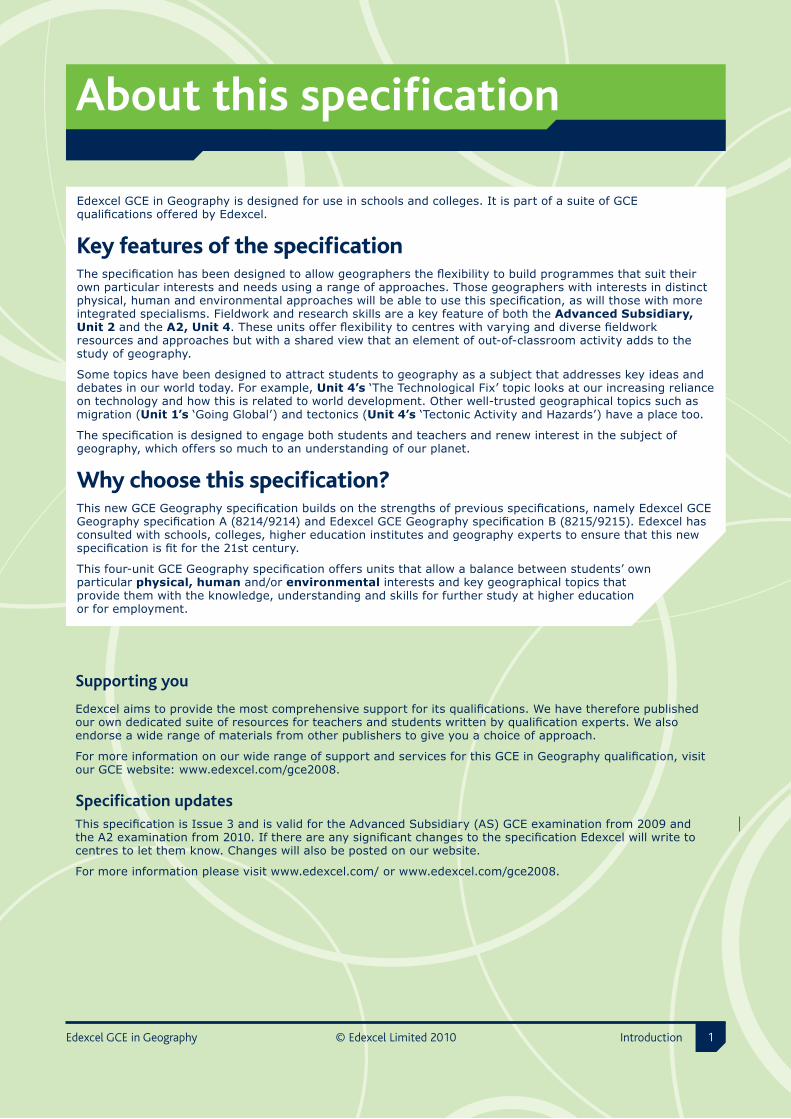
About �this �specification
Supporting �you
Edexcel aims to provide the most comprehensive support for its qualifications. We have therefore published our own dedicated suite of resources for teachers and students written by qualification experts. We also endorse a wide range of materials from other publishers to give you a choice of approach.
For more information on our wide range of support and services for this GCE in Geography qualification, visit our GCE website: www.edexcel.com/gce2008.
Specification �updatesThis specification is Issue 3 and is valid for the Advanced Subsidiary (AS) GCE examination from 2009 and the A2 examination from 2010. If there are any significant changes to the specification Edexcel will write to centres to let them know. Changes will also be posted on our website.
For more information please visit www.edexcel.com/ or www.edexcel.com/gce2008.
Edexcel GCE in Geography is designed for use in schools and colleges. It is part of a suite of GCE qualifications offered by Edexcel.
Key features of the specificationThe specification has been designed to allow geographers the flexibility to build programmes that suit their own particular interests and needs using a range of approaches. Those geographers with interests in distinct physical, human and environmental approaches will be able to use this specification, as will those with more integrated specialisms. Fieldwork and research skills are a key feature of both the Advanced Subsidiary, Unit 2 and the A2, Unit 4. These units offer flexibility to centres with varying and diverse fieldwork resources and approaches but with a shared view that an element of out-of-classroom activity adds to the study of geography.
Some topics have been designed to attract students to geography as a subject that addresses key ideas and debates in our world today. For example, Unit 4’s ‘The Technological Fix’ topic looks at our increasing reliance on technology and how this is related to world development. Other well-trusted geographical topics such as migration (Unit 1’s ‘Going Global’) and tectonics (Unit 4’s ‘Tectonic Activity and Hazards’) have a place too.
The specification is designed to engage both students and teachers and renew interest in the subject of geography, which offers so much to an understanding of our planet.
Why choose this specification?This new GCE Geography specification builds on the strengths of previous specifications, namely Edexcel GCE Geography specification A (8214/9214) and Edexcel GCE Geography specification B (8215/9215). Edexcel has consulted with schools, colleges, higher education institutes and geography experts to ensure that this new specification is fit for the 21st century.
This four-unit GCE Geography specification offers units that allow a balance between students’ own particular physical, human and/or environmental interests and key geographical topics that provide them with the knowledge, understanding and skills for further study at higher education or for employment.
Edexcel GCE in Geography © Edexcel Limited 20�0 Introduction

Contents © Edexcel Limited 20�0 Edexcel GCE in Geography2
Contents
A Specification at a glance 4
B Specification overview 9
Summary of assessment requirements 9
Assessment objectives and weightings 11
Relationship of assessment objectives to units 11
Qualification summary 11
C Geography unit content 15
Course structure 16
Unit 1 Global Challenges 17
Unit 2 Geographical Investigations 31
Unit 3 Contested Planet 49
Unit 4 Geographical Research 71
D Assessment and additional information 99
Assessment information 99
Additional information 102
E Resources, support and training 105
Resources to support the specification 105
Edexcel’s own published resources 105
Edexcel publications 106
Additional resources endorsed by Edexcel 106
Support 107
Training 108

Contents
Edexcel GCE in Geography © Edexcel Limited 20�0 Contents �
F Appendices 111
Appendix 1 Performance descriptions 113
Appendix 2 Key skills mapping 117
Appendix 3 Key skills development 119
Appendix 4 Wider curriculum 123
Appendix 5 Codes 125
Appendix 6 Glossary 127
Appendix 7 Disability Discrimination Act 129
Section A © Edexcel Limited 20�0 Edexcel GCE in Geography�
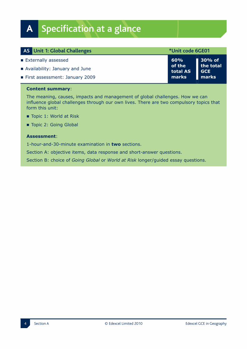
A Specification at a glance
AS Unit �1: �Global �Challenges *Unit �code �6GE01
Externally assessed
Availability: January and June
First assessment: January 2009
60% of the total AS marks
30% of the total GCE marks
Content summary:
The meaning, causes, impacts and management of global challenges. How we can influence global challenges through our own lives. There are two compulsory topics that form this unit:
Topic 1: World at Risk
Topic 2: Going Global
Assessment:
1-hour-and-30-minute examination in two sections.
Section A: objective items, data response and short-answer questions.
Section B: choice of Going Global or World at Risk longer/guided essay questions.

Specification at a glance A
Edexcel GCE in Geography © Edexcel Limited 20�0 Section A �
AS Unit �2: �Geographical �Investigations *Unit �code �6GE02
Externally assessed
Availability: January and June
First assessment: January 2009
40% of the total AS marks
20% of the total GCE marks
Content summary:
A closer look at how physical and human issues influence lives and can be managed. Students choose two topics from the four offered in this unit; there must be one physical and one human topic.
Physical topics
Topic 1: Extreme Weather, with its increasing ferocity and frequency, fascinates some people and threatens many others.
Topic 2: Crowded Coasts reveals how increasing development is testing our ability to manage these valued environments.
Human topics
Topic 3: Unequal Spaces explores the causes and consequences of rural and urban disparities and how to manage them.
Topic 4: Rebranding Places focuses on how we need to re-image and regenerate rural and urban places, using appropriate strategies.
Assessment:
1 hour 15 minutes examination in two sections.
The paper will assess the four optional topics offered. Candidates will answer one physical question from Section A and one human question from Section B. The questions require longer responses, each with three parts, designed to include data response, investigation and evaluation skills and related impacts/management issues.
* See Appendix 5 for description of this code and all other codes relevant to this qualification.

A Specification at a glance
Section A © Edexcel Limited 20�0 Edexcel GCE in Geography�
A2 Unit �3: �Contested �Planet *Unit �code �6GE03
Externally assessed
Availability: January and June
First assessment: January 2010
60% of the total A2 marks
30% of the total GCE marks
Content summary:
The use and management of resources is a key issue for geography in today’s world. Consumption patterns highlight stark inequalities between regions, countries and groups of people. Many resources are finite, and rising consumption means that difficult decisions over the use of resources will have to be taken more frequently. There are six compulsory topics:
Topic 1: Energy Security
Topic 2: Water Conflicts
Topic 3: Biodiversity Under Threat
Topic 4: Superpower Geographies
Topic 5: Bridging the Development Gap
Topic 6: The Technological Fix?
Assessment:
2-hour-and-30-minute examination in two sections. Students will be asked to select and answer two questions from five in Section A and all questions in Section B.
Section A: A choice of two short essay questions from five.
Section B (Synoptic Investigation): One question with three parts.
Specification at a glance A
Edexcel GCE in Geography © Edexcel Limited 20�0 Section A �
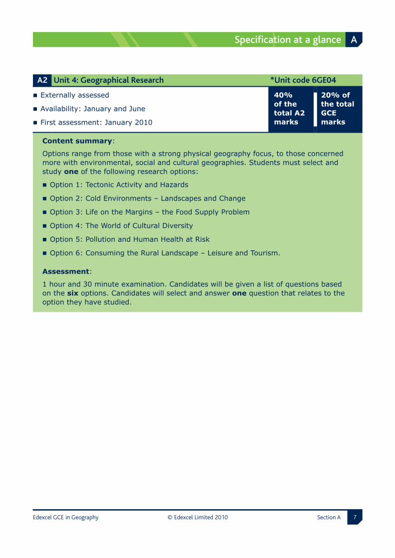
A2 Unit �4: �Geographical �Research *Unit �code �6GE04
Externally assessed
Availability: January and June
First assessment: January 2010
40% of the total A2 marks
20% of the total GCE marks
Content summary:
Options range from those with a strong physical geography focus, to those concerned more with environmental, social and cultural geographies. Students must select and study one of the following research options:
Option 1: Tectonic Activity and Hazards
Option 2: Cold Environments – Landscapes and Change
Option 3: Life on the Margins – the Food Supply Problem
Option 4: The World of Cultural Diversity
Option 5: Pollution and Human Health at Risk
Option 6: Consuming the Rural Landscape – Leisure and Tourism.
Assessment:
1 hour and 30 minute examination. Candidates will be given a list of questions based on the six options. Candidates will select and answer one question that relates to the option they have studied.

A Specification at a glance
Section A © Edexcel Limited 20�0 Edexcel GCE in Geography�
Edexcel GCE in Geography © Edexcel Limited 20�0 Section B �
B Specification overview
Summary of assessment requirements
Unit number and unit title
Level Assessment information Number of marks allocated in the unit
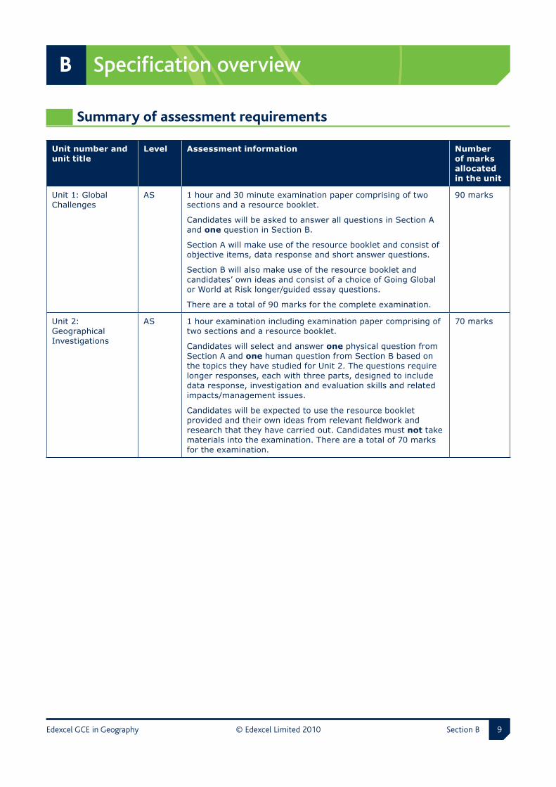
Unit 1: Global Challenges
AS 1 hour and 30 minute examination paper comprising of two sections and a resource booklet.
Candidates will be asked to answer all questions in Section A and one question in Section B.
Section A will make use of the resource booklet and consist of objective items, data response and short answer questions.
Section B will also make use of the resource booklet and candidates’ own ideas and consist of a choice of Going Global or World at Risk longer/guided essay questions.
There are a total of 90 marks for the complete examination.
90 marks
Unit 2: Geographical Investigations
AS 1 hour examination including examination paper comprising of two sections and a resource booklet.
Candidates will select and answer one physical question from Section A and one human question from Section B based on the topics they have studied for Unit 2. The questions require longer responses, each with three parts, designed to include data response, investigation and evaluation skills and related impacts/management issues.
Candidates will be expected to use the resource booklet provided and their own ideas from relevant fieldwork and research that they have carried out. Candidates must not take materials into the examination. There are a total of 70 marks for the examination.
70 marks

B Specification overview
Section B © Edexcel Limited 20�0 Edexcel GCE in Geography�0
Unit number and unit title
Level Assessment information Number of marks allocated in the unit
Unit 3: Contested Planet
A2 2 hour and 30 minute examination paper comprising of two sections and a resource booklet including synoptic resources.
The synoptic resources only will be pre-released to candidates as advance information four working weeks before the examination via the Edexcel website (www.edexcel.com). There is no restriction on the use of pre-released synoptic resources in teaching prior to the examination.
Candidates must not take their pre-released synoptic resources into the examination as these will be reproduced in the resource booklet.
Candidates will be asked to select and answer two questions from five in Section A and all questions in Section B.
Section A will consist of a choice of two data stimulus essay questions from five each totalling 25 marks. The five questions will be based on five of the six topics for Unit 3.
Section B (Synoptic investigation) will focus on the sixth topic unexamined in Section A. This topic will change in each exam sitting and will be revealed through the pre-released advance information. Section B will consist of one question in three parts. The total mark for the question will be 40. The question will make use of the pre-released synoptic materials reproduced in the examination resource booklet.
There are a total of 90 marks for the complete examination.
90 marks
Unit 4: Geographical Research
A2 1 hour and 30 minute examination.
Research focus material will be pre-released to candidates as advance information four working weeks before the examination via the Edexcel website (www.edexcel.com).
Candidates will be given a list of questions based on the six options. Candidates will select and answer one question that relates to the option they have studied. They will be required to write a long essay in which they demonstrate and synthesise the results of their research.
Each question is out of 70 marks.
Candidates will not be able to take any pre-released or research materials into the examination.
70 marks

Specification overview B
Edexcel GCE in Geography © Edexcel Limited 20�0 Section B ��
Assessment objectives and weightings
% in AS % in A2% in GCE
AO1Demonstrate knowledge and understanding of the content, concepts and processes.
60% 40% 50%
AO2Analyse, interpret and evaluate geographical information, issues and viewpoints and apply understanding in unfamiliar contexts.
24% 26% 25%
AO3Select and use a variety of methods, skills and techniques (including the use of new technologies) to investigate questions and issues, reach conclusions and communicate findings.
16% 34% 25%
TOTAL 100% 100% 100%
Relationship of assessment objectives to units
Unit number Assessment objective
AO1 AO2 AO3 Total for AO1, AO2 and AO3
Unit 1 22% 8% 0% 30%
Unit 2 8% 4% 8% 20%
Unit 3 14% 8% 8% 30%
Unit 4 6% 5% 9% 20%
Total for Advanced GCE
50% 25% 25% 100%
Qualification summary
Subject �criteria � The General Certificate of Education is part of the Level 3 provision. This specification is based on the Advanced Subsidiary GCE and Advanced Level GCE subject criteria for Geography; these are prescribed by the regulatory authorities and are mandatory for all awarding bodies.
B Specification overview
Section B © Edexcel Limited 20�0 Edexcel GCE in Geography�2
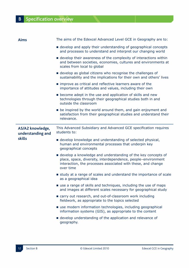
Aims The aims of the Edexcel Advanced Level GCE in Geography are to:
develop and apply their understanding of geographical concepts and processes to understand and interpret our changing world
develop their awareness of the complexity of interactions within and between societies, economies, cultures and environments at scales from local to global
develop as global citizens who recognise the challenges of sustainability and the implications for their own and others’ lives
improve as critical and reflective learners aware of the importance of attitudes and values, including their own
become adept in the use and application of skills and new technologies through their geographical studies both in and outside the classroom
be inspired by the world around them, and gain enjoyment and satisfaction from their geographical studies and understand their relevance.
AS/A2 �knowledge, �understanding �and �skills
This Advanced Subsidiary and Advanced GCE specification requires students to:
develop knowledge and understanding of selected physical, human and environmental processes that underpin key geographical concepts
develop a knowledge and understanding of the key concepts of place, space, diversity, interdependence, people–environment interaction, the processes associated with these, and change over time
study at a range of scales and understand the importance of scale as a geographical idea
use a range of skills and techniques, including the use of maps and images at different scales necessary for geographical study
carry out research, and out-of-classroom work including fieldwork, as appropriate to the topics selected
use modern information technologies, including geographical information systems (GIS), as appropriate to the content
develop understanding of the application and relevance of geography.

Specification overview B
Edexcel GCE in Geography © Edexcel Limited 20�0 Section B ��
A2 �knowledge, �understanding �and �skills �
In addition, the Edexcel Advanced GCE specification requires students to:
undertake individual research/investigative work, including fieldwork
extend their understanding of geographical ideas, concepts and processes
identify and analyse the connections between the different aspects of geography
analyse and synthesise geographical information in a variety of forms and from a range of sources
consider new ideas and developments about the changing nature of geography in the 21st century
critically reflect on and evaluate the potential and limitations of approaches and methods used both in and outside the classroom.

B Specification overview
Section B © Edexcel Limited 20�0 Edexcel GCE in Geography��

Edexcel GCE in Geography © Edexcel Limited 20�0 Section C ��
C Geography unit content
Unit 1 Global Challenges 17
Unit 2 Geographical Investigations 31
Unit 3 Contested Planet 49
Unit 4 Geographical Research 71
C Geography unit content
Section C © Edexcel Limited 20�0 Edexcel GCE in Geography��
Course structure
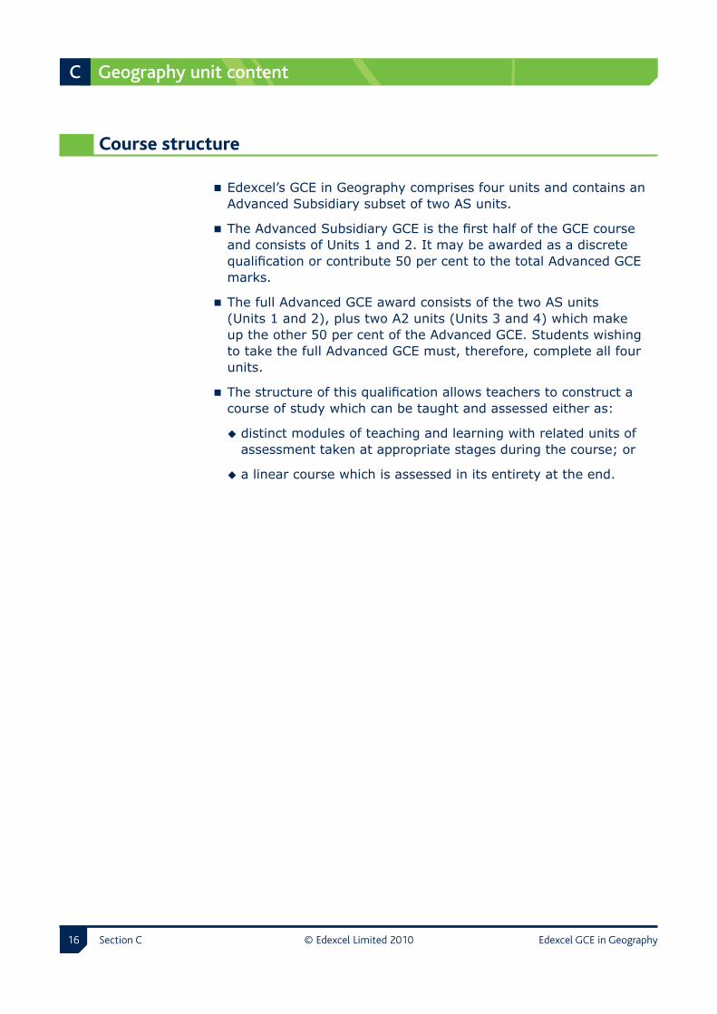
Edexcel’s GCE in Geography comprises four units and contains an Advanced Subsidiary subset of two AS units.
The Advanced Subsidiary GCE is the first half of the GCE course and consists of Units 1 and 2. It may be awarded as a discrete qualification or contribute 50 per cent to the total Advanced GCE marks.
The full Advanced GCE award consists of the two AS units (Units 1 and 2), plus two A2 units (Units 3 and 4) which make up the other 50 per cent of the Advanced GCE. Students wishing to take the full Advanced GCE must, therefore, complete all four units.
The structure of this qualification allows teachers to construct a course of study which can be taught and assessed either as:
distinct modules of teaching and learning with related units of assessment taken at appropriate stages during the course; or
a linear course which is assessed in its entirety at the end.

Edexcel GCE in Geography © Edexcel Limited 20�0 Section C ��
Unit 1 Global Challenges AS compulsory unit Externally assessed
1.1 Unit description
Overview This unit poses questions which seek to explore the meaning, causes and impacts of a number of headline global issues. It gives students the opportunity to evaluate existing attempts to manage the problems they bring and challenges us to find solutions for the 21st century. Whilst its scale is global it is important that students can relate these issues to their own situations, becoming aware that they too can have a say in and play a part in meeting these global challenges.
Topics There are two compulsory topics that look at some of the ‘big issues’ which face us all:
Topic 1: World at Risk – includes an introduction to a range of global natural hazards which threaten some areas of the world more than others and then focuses on climate change and global warming, seen by many as our greatest environmental challenge.
Topic 2: Going Global – brings together today’s rapid economic changes which are impacting unfairly on people across the globe, and the related international issues of population change and migration.
1.2 Assessment information
Time �and �material 1 hour and 30 minute examination paper and resource booklet.
Questions �and �marks
Candidates will be asked to answer all questions in Section A and one question in Section B.
Section A will make use of the resource booklet and consist of data response, short-answer questions and objective items.
Section B will also make use of the resource booklet and candidates’ own ideas and consist of a choice of Going Global or World at Risk longer/guided essay questions.
There are a total of 90 marks for the complete examination.

Unit 1 Global Challenges
Section C © Edexcel Limited 20�0 Edexcel GCE in Geography��
1.3 Topic 1: World at Risk
Global �hazards Global natural hazards vary in type and distribution and fall into two main categories – hydrometeorological and geophysical. The risks involved can turn hazards into natural disasters. This is especially true where a number of hazards occur together and where the population is already vulnerable – often as a result of high population density or poverty. These multiple hazard hotspots show how – when faced with disaster – the poor lose lives and the rich may lose money.
Climate �change Climate change is considered by many to be the world’s greatest problem (technically a context hazard); and so a chronic, large-scale threat to people. Uncertainty about its impact is inevitable as scientists struggle to make firm predictions. It is an unfair world in which the wealthiest countries have emitted most of the greenhouse gases and the poorest ones are most vulnerable to their impacts. This topic poses questions about the causes of global warming, its relationship to long-term climate change, and the direct and indirect impacts that result.
It also considers some of the solutions, whether global or local, and the complexity of managing international concerns against a background of national and personal self-interest. It also provides suggestions for tackling a variety of global hazards.

Global Challenges Unit 1
Edexcel GCE in Geography © Edexcel Limited 20�0 Section C ��
1 � Global �hazards
Enquiry �question: What are the main types of physical risks facing the world and how big a threat are they?
What �students �need �to �learn Suggested �teaching �and �learning
Disasters result when hydro-meteorological hazards (cyclones, droughts and floods); and geophysical hazards (earthquakes, volcanoes and landslides/avalanches) threaten the life and property of increasing numbers of the world’s people.
Exploring the concepts, processes and terminology relating to natural hazards, disasters and global warming.
The Risk of disaster grows as global Hazards and people’s Vulnerability increases, while their Capacity to cope decreases.
Making use of the disaster risk equation: R = H x V C
Global warming arguably the greatest hazard we currently face is a chronic hazard; has widespread impacts; raises issues of injustice (polluters and vulnerable victims); and has complex solutions.
Assessing the status of global warming as the world’s number one problem.
(This is foundation work that may be used as a starting point or incorporated into the teaching of this unit as required, depending upon the prior learning of students.)
Unit 1 Global Challenges
Section C © Edexcel Limited 20�0 Edexcel GCE in Geography20
2 � Global �hazard �trends
Enquiry �question: How and why are natural hazards now becoming seen as an increasing global threat?
What �students �need �to �learn Suggested �teaching �and �learning
Some types of hazards are increasing in magnitude and frequency, and having greater impacts upon people and their lives.
Researching databases (eg CRED) for evidence of the size and frequency of the top six global natural hazards (cyclones, droughts, floods, earthquakes, volcanoes and landslides/avalanches) upon lives, property, infrastructure and GDP.
Natural disasters are increasing because of a combination of physical and human factors
the unpredictability of global warming and El Niño events leading to increasing natural hazards
the increasing exploitation of resources (eg deforestation), world poverty, rapid population growth and urbanisation.
Exploring examples of how natural and human activities are combining to cause increasing disaster scenarios eg storms, floods and population change.
Trends show that the number of people killed is falling, whereas the number affected, and the economic losses are escalating.
Developing an awareness of how and why disasters are affecting more people and causing more damage yet lives are being saved, using examples of hazard events.
Global Challenges Unit 1
Edexcel GCE in Geography © Edexcel Limited 20�0 Section C 2�
3 � Global �hazard �patterns
Enquiry �question: Why are some places more hazardous and disaster-prone than others?
What �students �need �to �learn Suggested �teaching �and �learning
An assessment of the real or potential natural hazard risks by using evidence about past or likely future events and their impact on people, property and the environment in their local area.
Exploring the local area to assess the risks from natural hazards such as flooding and global warming.
The distribution of the world’s major natural hazards both hydrometeorological hazards and geophysical hazards (see 1).
Comparing and explaining various global distributions via maps and reports like the World Bank Hazard Management Unit.
Disaster hotspots occur when two or more hazards occur in vulnerable places:
case study of the California coast
case study of the Philippines; a vulnerable location.
Researching the causes, impacts and interaction of multiple hazards in contrasting hotspots.

Unit 1 Global Challenges
Section C © Edexcel Limited 20�0 Edexcel GCE in Geography22
4 � Climate �change �and �its �causes
Enquiry �question: Is global warming a recent short term phenomenon or should it be seen as part of longer-term climate change?
What �students �need �to �learn Suggested �teaching �and �learning
The current phenomenon of global warming should be set in the context of longer, medium and short term climate change. A range of evidence from ecology, historical records and climate change should be reviewed.
Researching the evidence of:
longer-term, eg pollen analysis, ice cores, and past glacial/sea level change
medium-term, eg historical records, tree rings and retreating glaciers
recent, eg scientific research from weather, ocean, polar ice and ecosystem changes.
The causes of climate change may be both natural and human (anthropogenic).
Exploring the role of variations in earth orbit, solar output, cosmic collision and volcanic emissions, as well as enhanced greenhouse gas emissions.
Recent climate change (global warming) is unprecedented in historical terms and scientists now argue that human causes may be more to blame.
Assessing whether global warming is something unique or just a medium-term trend in the longer term pattern of climate variations.
Global Challenges Unit 1
Edexcel GCE in Geography © Edexcel Limited 20�0 Section C 2�
5 � The �impacts �of �global �warming
Enquiry �question: What are the impacts of climate change and why should we be concerned?
What �students �need �to �learn Suggested �teaching �and �learning
The direct impacts of projected global climate changes:
a case study of environmental and ecological impacts of Arctic warming in the Arctic region
a case study of the complexities of economic impacts across the African continent and how it could lead to disasters for poor people.
Developing an awareness of the direct impacts of global warming through case studies of vulnerable places to understand the resulting environmental, ecological and economic impacts.
The indirect impacts such as the eustatic rise in sea level (global inundation).
Investigating how sea level rise may have a disproportionately bigger effect on some countries using examples such as the South Sea islands or Bangladesh (the disaster scenario).
The impacts of climate change are difficult to predict and emissions scenarios, such as the IPCC model, may vary (from ‘business as usual’ to sustainable) and could be affected by attempts to manage the impacts of climate change.
Researching the value of different scenarios and models in predicting future trends such as rising sea levels.
The evidence that combined impacts could lead to catastrophic, irreversible changes and contribute to a more hazardous world.
Exploring the concept of a ‘tipping point’.

Unit 1 Global Challenges
Section C © Edexcel Limited 20�0 Edexcel GCE in Geography2�
6 � Coping �with �climate �change
Enquiry �question: What are the strategies for dealing with climate change?
What �students �need �to �learn Suggested �teaching �and �learning
How strategies:
attempt to limit the impacts of climate change at various scales
involve adapting to climate change.
Weighing up mitigation strategies and adaptation strategies using a range of examples of each.
The conflicting views and role of the key players in managing climate change – including governments, business, NGOs, individuals and groups. The complexities of a global agreement.
Developing an awareness of:
the complexities of a global agreement such as the Kyoto protocol and its implications for specific countries
national and small-scale strategies for limiting climate change
the contributions of individuals to help reduce the impacts of climate change, eg carbon footprints.
Whilst most people argue for ‘act local, think global’, management is needed at all scales and progress is likely to be incremental.

Global Challenges Unit 1
Edexcel GCE in Geography © Edexcel Limited 20�0 Section C 2�
7 � The �challenge �of �global �hazards �for �the �future
Enquiry �question: How should we tackle the global challenges of increasing risk and vulnerability in a more hazardous world?
What �students �need �to �learn Suggested �teaching �and �learning
Increasing risk and uncertainty threatens major disruption to people and the environment at a global scale bringing water shortages and food insecurity.
Developing an awareness of how other global problems (eg conflict, famine, climate change and poverty) make managing global hazards more difficult.
The world should recognise that global warming is one of the biggest challenges it has faced and make innovative choices, adopt sustainable strategies and understand the cost and benefits involved.
Investigating and weighing up strategies to manage global warming, such as energy efficiency, conservation, decreasing carbon emissions, alternative energy and reafforestation.
Solutions to a hazardous world, at all scales, need to focus on the underlying issues of risk and vulnerability.
Developing an awareness of, for example, local flood risk, regional poverty and international strategies to tackle a world at risk.

Unit 1 Global Challenges
Section C © Edexcel Limited 20�0 Edexcel GCE in Geography2�
1.4 Topic 2: Going Global
Globalisation Globalisation and the links it creates is happening at an ever-increasing pace. Whilst some argue that it spreads wealth and power in beneficial ways, there is widespread concern about the way in which globalisation impacts on economies, societies and environments. Many researchers argue that it is creating an unfair world in which rich consumers exploit the world’s poorest peoples, who remain unfairly or poorly connected to the wider world. Action to develop a more sustainable approach to these challenges is leading to difficult decisions at a variety of scales from the individual to global markets.
Population �migration
One of globalisation’s inevitable effects is that people are encouraged to move to escape from poverty or to take advantage of new opportunities. This escalating population migration (both within and between countries) is creating a new population dynamic. The rate of these changes is occurring at all scales, challenging individuals, communities and governments. Students will research the growth of megacities and migration relating to EU enlargement, as well as undertaking a brief personal demographic study linking their own roots with the wider global picture.
The consequences of going global are considerable but there needs to be a realisation that global agreements, green strategies and ethical purchases can modify the negative results of globalisation.
1 � Globalisation
Enquiry �question: What is globalisation and how is it changing people’s lives?
What �students �need �to �learn Suggested �teaching �and �learning
The concept and development of globalisation (the connections between people and environments across the globe).
Exploring the concepts, processes and terminology relating to globalisation, population change and migration.
The factors which have accelerated globalisation.
Investigating the expansion of TNCs, international organisations and global markets.

Global Challenges Unit 1
Edexcel GCE in Geography © Edexcel Limited 20�0 Section C 2�
The effects of globalisation on population movements.
Exploring the nature of the unprecedented numbers of voluntary/economic migrants.
(This foundation work may be used as a starting point or incorporated into the teaching of this unit as required, depending upon the prior learning of students.)
2 � Global �groupings
Enquiry �question: What are the main groupings of nations and what differences in levels of power and wealth exist?
What �students �need �to �learn Suggested �teaching �and �learning
The disparities in global wealth and poverty, through broad economic and political groupings of countries (such as NICs, OPEC, LEDCs, LDCs, OECD, and trade blocs like NAFTA).
Developing an awareness of the various ways of classifying nations into global groupings and how these change over time, in response to international trade agreements and changes in wealth and power.
TNCs play a crucial role in the development and spread of global business and trade.
Investigating the role of TNCs and their global significance, using a suitable case study.

Unit 1 Global Challenges
Section C © Edexcel Limited 20�0 Edexcel GCE in Geography2�
3 � Global �networks
Enquiry �question: Why, as places and societies become more interconnected, do some places show extreme wealth and poverty?
What �students �need �to �learn Suggested �teaching �and �learning
Global networks (such as air travel, TNCs, and tourism) create flows of trade, money, workers and information, which ‘switch on’ some places making them rich and powerful; while others may become ‘switched off’ and remain poor.
Investigating how examples of global networks create global patterns and can increase or decrease connectivity.
The role of technology (such as communications and the internet) in a shrinking world.
Researching the role of air travel, telecoms and the internet in promoting an interconnected world.
Why some places are ‘winners’ as significant producers and consumers, having valuable physical and human resources; whereas others are ‘losers’ remaining poorly connected.
Researching how natural resources, energy, labour pools, skills, and culture can be magnets for investment and influence global connectivity, allowing new Indian and Chinese companies to be ‘winners’ and parts of Africa ‘losers’.
4 � Roots
Enquiry �question: How does evidence from personal, local and national sources help us understand the pattern of population change in the UK?
What �students �need �to �learn Suggested �teaching �and �learning
An analysis of population change (family size, population structure, migration, employment and social aspirations) using family histories or records.
Investigating by family tree/history or records how the local population has changed.
How social and economic factors such as 20th century changes in patterns of work and improvements in health, hygiene, nutrition and education have had an impact on UK population and migration.
Researching the depression, baby boom, decline of heavy industry, south east drift in the UK and the growth of consumerism.

Global Challenges Unit 1
Edexcel GCE in Geography © Edexcel Limited 20�0 Section C 2�
The geographical challenges resulting from a greying population.
Researching the economic and social effects of an ageing population eg dependency, retirement, health and welfare provision.
5 � On �the �move
Enquiry �question: How is migration changing the face of the EU?
What �students �need �to �learn Suggested �teaching �and �learning
Key migrations into Europe at an international scale, contrasting recent and earlier (post-colonial) flows.
Developing an awareness of the cultural-economic linkages between European countries and the wider world.
Key movements within Europe include:
a case study of post-accession labour flows from eastern Europe
a case study of retirement flows to Mediterranean locations.
Researching and explaining movements of Polish and other workers to the UK, and Britons retiring to Spain.
The economic, social, environmental and political consequences of these movements and the issues and reactions they create.
Weighing up the consequences such as nationalism, culture, religion, citizenship and immigration policy/controls.
6 � World �cities
Enquiry �question: What is driving the new urbanisation taking place and what are its consequences?
What �students �need �to �learn Suggested �teaching �and �learning
How rural-urban population migration feeds the growth of million and megacities.
Showing awareness of the causes and processes of rural to urban migration.

Unit 1 Global Challenges
Section C © Edexcel Limited 20�0 Edexcel GCE in Geography�0
Megacities in differing countries develop in contrast ways, focusing on destinations for newcomers (shanty towns and inner city) and movers (suburbanisation).
Researching and appreciating the diversity of two megacities (the cycle of urbanisation in one developed world megacity, eg London, Los Angeles and one developing word megacity, eg Shanghai, Lagos).
The consequences of this new growth, especially in megacities and whether it can be sustained.
Thinking critically about cities of the future, especially in China and India, and whether sustainable urban living is achievable.
7 � Global �challenges �for �the �future
Enquiry �question: What are the social and environmental consequences of globalisation and can we manage these changes for a better world?
What �students �need �to �learn Suggested �teaching �and �learning
Globalisation brings both positive and negative changes ie a two-speed world.
Weighing up the positive and negative effects of mass purchasing of commodities, such as food miles, exporting jobs, packaging and worker exploitation, etc.
The moral and social consequences of globalisation, such as the exploitation of workers or cultures in some countries.
Thinking critically about whether the lives of rural to urban migrants are improved.
Reducing the environmental and social costs of globalisation requires action at a variety of scales from local (recycling/landfill etc) to global (carbon credit trading, etc).
Researching and weighing up the viability of conservation and green strategies and the difficult decisions individuals, societies, businesses and countries may have to take.
The viability of green strategies and ethical purchases to conserve and manage resources to create a more equitable world (such as buying locally or fair trading).
Developing an awareness that countries and individual consumers can have impacts on global poverty brought about by globalisation.
Edexcel GCE in Geography © Edexcel Limited 20�0 Section C ��
Unit 2 Geographical Investigations AS compulsory unit Externally assessed
2.1 Unit description
Overview Students must choose one physical topic and one human topic from the four topics offered in this unit.
Physical topics
Topic 1: Extreme Weather, with its increasing ferocity and frequency, fascinates some people and threatens many others.
OR
Topic 2: Crowded Coasts reveals how increasing development is testing our ability to manage these valued environments.
Human topics
Topic 3: Unequal Spaces explores the causes and consequences of rural and urban disparities and how to manage them.
OR
Topic 4: Rebranding Places focuses on how we need to re-image and regenerate rural and urban places, using appropriate strategies.
Topics Fieldwork, research and practical work are all seen as a part of the wider investigation process. They form an intrinsic part of each of these topics and this will be reflected in their assessment by examining various parts of the geographical enquiry sequence. Simple GIS should be used to contextualise and enhance the fieldwork activities in this unit.
The physical topics pose questions which explore how we might best manage some of the challenges we face from the natural world, while the human topics focus on our need to better manage rural and urban places in the 21st century. They give students the opportunity to look at issues at a local or small scale, relating these to their own lives and experiences as well as comparing their research areas to a wider world context.

Section C © Edexcel Limited 20�0 Edexcel GCE in Geography�2
Unit 2 Geographical Investigations
2.2 Assessment information
Time �and �materials 1 hour 15 minutes examination paper comprising of two sections and a resource booklet.
Questions �and �marks
Candidates will select and answer one physical question from Section A and one human question from Section B based on their chosen topics. The questions require longer responses, each with three parts, designed to include data response, investigation and evaluative skills and related impacts/management issues. Each question will be worth 35 marks.
Candidates will be expected to use the resource booklet provided, their own ideas, relevant fieldwork and research which they have carried out. Candidates must not take materials into the examination.
There are a total of 70 marks for the examination.
2.3 Topic 1: Extreme Weather
Extreme �weather Extreme weather includes a range of phenomena that involve extremes of temperature, precipitation, wind and atmospheric pressure. They in turn develop from a variety of meteorological conditions. This topic looks at how extreme weather events lead to immediate, subsequent and longer term hazards. Storms, river floods and drought clearly illustrate the environmental, social and economic impacts of extreme weather – impacts that are closely related to the type of hazard involved and the economic situation of those affected. Risks from extreme weather, such as flooding, are increasing and much of this is our fault. If extreme weather conditions are becoming more frequent and more severe, then tougher, fairer and more intelligent decisions will need to be taken in both the short and longer term.
Fieldwork �and �research �opportunities
Fieldwork opportunities include a weather log, flood impacts survey, flood/drought risk assessments and flood management assessments. Research work could relate to weather records, satellite images, hurricane data, and use of statistics for flood/drought events as well as evaluations of various management strategies.

Edexcel GCE in Geography © Edexcel Limited 20�0 Section C ��
Geographical Investigations Unit 2
1 � Extreme �weather �watch
Enquiry �question: What are extreme weather conditions and how and why do they lead to extreme weather events?
What �students �need �to �learn Suggested �teaching �and �learning
There is a wide variety of extreme (severe or unexpected) weather phenomena.
Defining and examining the nature and distribution of different types of extreme weather, such as tropical cyclones, temperate storms, tornadoes, flooding, blizzards, winter weather, heat waves, fires, and drought.
Fieldwork and research, using a weather diary and synoptic maps, into meteorological conditions (air masses, pressure systems and fronts) which can influence changes in temperatures, precipitation and winds. These lead to contrasting weather events such as the development of a depression or seasonal anticyclones.
Using primary and secondary sources to monitor and understand how differing weather patterns relate to underlying meteorological conditions.
Contrasting examples of how extreme weather conditions develop such as hurricanes, snow and ice, and drought.
Researching meteorological processes such as a hurricane sequence, UK or USA winter conditions and an extended drought.
2 � Extreme �impacts
Enquiry �question: What are the impacts of extreme weather on people, the economy and the environment?
What �students �need �to �learn Suggested �teaching �and �learning
An extreme weather hazard can have different impacts depending on the severity of the event, a location’s level of economic development and the vulnerability of those affected.
Researching how the impacts of extreme weather vary in intensity and in different parts of the world.
Section C © Edexcel Limited 20�0 Edexcel GCE in Geography��
Unit 2 Geographical Investigations
Fieldwork and research into the social, economic and environmental impacts of extreme weather created by:
an immediate disastrous weather event – such as a tornado or hurricane
a subsequent additional hazard – such as localised river flooding
a longer-term trend or condition – such as a heat wave or drought.
Using primary and secondary sources to investigate impacts on homes, business, health, lives, infrastructure, production and habitats.
Examining specific examples of the impacts of extreme weather events, such as Hurricane Mitch, a localised flood event and drought in New South Wales as well as examples relating to similar current events.
3 � Increasing �risks
Enquiry �question: How are people and places increasingly at risk from and vulnerable to extreme weather?
What �students �need �to �learn Suggested �teaching �and �learning
Evidence that extreme weather hazards in the UK and elsewhere are becoming more frequent and involve higher risk due to natural and human causes such as climate change, demographics and land management.
Investigating how the increased incidence and risk of weather hazards is affected by climate change, global warming, population growth along rivers and coastlines, and poor management of land.
Fieldwork and research to investigate how a small stream or part of a river catchment can suffer increased flood risks resulting from:
meteorological causes
the physical characteristics of the area
growing urbanisation, land use change and attempts at management.
Using primary and secondary sources to investigate and analyse a range of causes of increased flood risks at a local scale such as in Carlisle or Uckfield, including for example:
heavy/prolonged precipitation or snow melt
geology, vegetation and slopes
land use and management.

Edexcel GCE in Geography © Edexcel Limited 20�0 Section C ��
Geographical Investigations Unit 2
4 � Managing �extreme �weather
Enquiry �question: How can we best respond to and cope with the impacts of extreme weather?
What �students �need �to �learn Suggested �teaching �and �learning
Fieldwork and research into ways of managing and responding to extreme weather events using short- and longer-term strategies, and how some management strategies are more successful than others.
Using primary and secondary sources to investigate strategies such as USA hurricane warning, Environment Agency flood protection and risk assessments at a local scale, eg York.
The role of new technology in improving community preparedness, event forecasting and reducing impacts of disasters.
Researching the role of technology and its application to extreme weather management such as forecasting (NOAA), flood monitoring or the use of drought resistant crops.
Ways to manage drought through physical, social, economic and political responses in contrasting areas.
Assessing sustainable longer-term solutions for tackling drought such as water management and adapting farming techniques as in south east England or Ethiopia.
2.4 Topic 2: Crowded Coasts
Crowded �coasts The coastal zone is one of the most densely populated areas globally because of favourable locational factors, yet it is an area of immense environmental value. This topic allows students to carry out detailed studies of contrasting coastal environments at a local/small scale, exploring competing and conflicting land uses, and evaluating the pressures created by development. It considers how vulnerable and valuable coastlines face a growing physical risk from rapid coastal erosion and coastal flooding. It provides an overview of coastal management, looking at protection and conservation strategies for the present and the future.
Section C © Edexcel Limited 20�0 Edexcel GCE in Geography��
Unit 2 Geographical Investigations
Fieldwork �and �research �opportunities
Fieldwork opportunities include surveys of coastal development and land use, coastal management, and the state of the coastal environment. Opportunities for research work include satellite images to show coastal change, maps to calculate coastal erosion, shoreline management and statistics for coastal retreat and flooding.
1 � Competition �for �coasts
Enquiry �question: Why is the coastal zone so favoured for development?
What �students �need �to �learn Suggested �teaching �and �learning
How physical factors create variety in a range of different coastal environments.
Examining the range of natural factors that influence coastal environments and their value, eg geology, geomorphology and ecosystems.
The factors which have led to exponential population growth in some coastal environments:
flat land, soil fertility, equable climate, and biodiversity
potential for fishing, recreation/tourism, industrial and port development and accessibility.
Developing awareness of the exponential population growth in accessible and popular coastal areas.
Fieldwork and research to show how these factors have shaped the development and growth of contrasting crowded coasts over time.
Investigating the growth of contrasting crowded coasts such as a UK resort coastline and a foreign one eg a Spanish Costa or the Florida coast.

Edexcel GCE in Geography © Edexcel Limited 20�0 Section C ��
Geographical Investigations Unit 2
2 � Coping �with �the �pressure
Enquiry �question: How do various coastal developments create competition and conflict? How can these pressures be resolved?
What �students �need �to �learn Suggested �teaching �and �learning
How development lead to patterns of zoning in coastal areas and how competition for space puts pressure on coastal environments.
Exploring:
land use in a resort/port
the need for planning control as the available land decreases and rate of development intensifies.
Fieldwork and research into the pressures on the coast when development and conservation meet head on including:
the overuse of resources, pollution, other developments
the destruction of high-value coastal habitats.
Using primary and secondary sources to investigate the pressures associated with coastal development, eg:
analysing the impacts of fishing, aquaculture, marine and beach pollution and tourism
assessing the value of and level of destruction in, eg sand dunes, salt marshes or SSSIs.
There are economic benefits and environmental costs to coastal development which influence the success of the development equation and involve the views of stakeholders and their conflicting needs.
Exploring a suitable case study eg Dibden Bay or Akamas (Cyprus) to:
assess the beneficial economic impacts of development against the environmental costs (using, eg CBA and Environmental Impact As)
examining the views and objectives of interested parties (using Conflict matrices and values analysis).
Section C © Edexcel Limited 20�0 Edexcel GCE in Geography��
Unit 2 Geographical Investigations
3 � Increasing �risks
Enquiry �question: How is coastal development increasingly at risk from and vulnerable to physical processes?
What �students �need �to �learn Suggested �teaching �and �learning
The growing level of coastal development faces increasing risks from coastal erosion and flooding because of:
rapid coastal erosion along vulnerable coasts
the impact of rising sea levels in areas of dense population and high value installations, particularly those that may be subject to tsunamis and storm surges.
Developing an awareness of how coastal environments are threatened by the growing incidence of coastal hazards such as rapid erosion in Holderness and flooding in the Thames estuary and Aceh (Indonesia).
Fieldwork and research into rates of coastal retreat or degree of coastal flood risk and the resulting impacts on developments and people at a small scale.
Using primary and secondary sources to investigate and analyse the pace and impacts of coastal erosion or flooding such as at Towyn, Start Bay or Holderness.
4 � Coastal �management
Enquiry �question: How is coastal management adapting to new ideas and situations?
What �students �need �to �learn Suggested �teaching �and �learning
How the spectrum of coastal management strategies (hard engineering to ‘do nothing’) has evolved into shoreline management planning.
Investigating the range of coastal defences available, both traditional and modern, and how the various options relate to what is feasible, cost-effective and appropriate.

Edexcel GCE in Geography © Edexcel Limited 20�0 Section C ��
Geographical Investigations Unit 2
Fieldwork and research into:
the success of coastal defence schemes
the value of strategies used to manage a high value coastal environment.
Using primary and secondary sources to investigate and evaluate:
the success of coastal defences along a small stretch of coastline, eg Start Bay
the conservation and management of a fragile or outstanding coastline eg, Oxwich or Purbeck.
Management strategies for the future include sustainable and integrated approaches such as coastal realignment and Shoreline Management plans (ICZM).
Assessing the value of sustainable and ecological approaches using suitable examples such as the Blackwater estuary (Essex), the Sussex SMP or the Northumberland ICZM.
2.5 Topic 3: Unequal Spaces
Rural �and �urban �inequality
Movements of people, money and changing opportunities affect all parts of the rural-urban continuum. Whilst some areas flourish, others struggle and inequalities develop at a variety of scales – even between neighbouring people and groups. This topic explores the social, political and economic causes of disparities and identifies the ‘haves and have-nots’. It then focuses on a more detailed evaluation of a range of strategies which have been designed to remove or manage inequalities, in the countryside, towns and cities.
Fieldwork �and �research �opportunities
Fieldwork opportunities include local environmental and housing quality surveys, investigating disparity of crime/vandalism, access to services and mobility (especially in rural areas, eg emergency services, travel, shopping and education). Investigations might examine the causes of inequality, using surveys, questionnaires or oral histories, or evaluate the impacts of schemes and projects trying to tackle inequality. Opportunities for research work could make use of census data to show the pattern of disparity/inequality of opportunity. It could also involve use of Landsat, planning documents, maps and statistics (eg crime or service provision), evaluating decline or improvement over time. Rural work could involve applying a modern day Cloke’s index.

Section C © Edexcel Limited 20�0 Edexcel GCE in Geography�0
Unit 2 Geographical Investigations
1 � Recognising �inequality
Enquiry �question: What are unequal spaces and what causes them?
What �students �need �to �learn Suggested �teaching �and �learning
The idea of inequality at a variety of scales and in contrasting areas.
Developing an awareness of inequalities in different areas.
The processes that lead to uneven levels of environmental quality, social opportunity, wealth (and poverty) and quality of life.
Researching the processes that create differing levels of inequality in people’s lives.
Fieldwork and research, to explore the pattern of spatial inequality in one rural and one urban area using primary surveys and secondary data.
Using primary and secondary sources to investigate patterns of spatial inequality such as land use, environmental quality, accessibility/mobility, zones of exclusion together with census data, employment figures, planning documents, and old maps and photographs.
2 � Inequality �for �whom?
Enquiry �question: What impact do unequal spaces have on people?
What �students �need �to �learn Suggested �teaching �and �learning
Inequality can lead to social and economic exclusion and polarisation, by denying opportunities and access to services in urban and rural areas.
Investigating the impacts of reduced opportunities and facilities in rural and urban areas such as in deprived areas of inner cities, peripheral estates, shanty towns, and contrasting remote rural areas.
How inequality creates marginalised groups in a variety of ways in rural and urban areas.
Becoming aware of how we can all experience the effects of inequality by gender, age, race and religion, employment, education, income, health and disability.
Edexcel GCE in Geography © Edexcel Limited 20�0 Section C ��
Geographical Investigations Unit 2
Fieldwork and research into inequality can help to:
produce criteria to identify the spatial pattern of the ‘haves’ and ‘have-nots’ in rural and urban areas
design a checklist to evaluate schemes to tackle inequality.
Using primary and complementary secondary (statistics and census) information to:
investigate spatial patterns of inequality using evidence of deprivation based on ideas above, eg poverty, housing, quality of life, segregation
audit could be based on ‘outputs’ such as jobs created, new business start-ups, etc and ‘outcomes’ like changes in socio-economic or physical conditions.
3 � Managing �rural �inequalities
Enquiry �question: How can we manage rural inequality and improve the lives of the rural poor? How successful have particular schemes been?
What �students �need �to �learn Suggested �teaching �and �learning
There are serious social, economic and environmental problems and barriers creating rural inequality that need to be overcome.
Examining the main problems and barriers to equality including lack of access to affordable housing, local employment and basic services.
Fieldwork and research into the success of specific examples of ways to reduce rural inequalities using contrasting solutions such as:
appropriate technology
community involvement and empowerment
improving access to transport and services
local employment
sustainable solutions.
Using primary (eg including video and audio evidence, survey of functions/employment) and secondary sources to investigate the success of named rural schemes involving for example:
broadband access, reliable water supplies
help for women, co-operatives, self-help groups
dial a bus, mobile services, deliveries, post offices in pubs
farming for environmental protection, diversification
National Parks, co-operatives, bottom-up strategies.

Section C © Edexcel Limited 20�0 Edexcel GCE in Geography�2
Unit 2 Geographical Investigations
4 � Managing �urban �inequalities
Enquiry �question: What strategies can be used to combat inequality in urban areas? How successful have particular schemes been?
What �students �need �to �learn Suggested �teaching �and �learning
There are social, economic and environmental problems associated with urban inequalities and key players are involved in delivering solutions.
Developing awareness of the problems associated with urban inequality and the key players such as international agencies, charities, governments, local and regional authorities, groups and individuals.
Fieldwork and research into the success of specific examples of ways to reduce urban inequalities using contrasting solutions such as:
self-help schemes
traffic and public transport
town planning initiatives
business initiatives
crime and policing.
Using primary and secondary resources to investigate the success of named urban schemes involving for example:
shanty builds, residents associations, neighbourhood watch
congestion charging, park and ride, Oystercards
sustainable communities, WHO Urban Healthy Planning Initiative
minimum wage, furniture schemes, targeted recruitment form particular communities
video surveillance, neighbourhood policing.
Edexcel GCE in Geography © Edexcel Limited 20�0 Section C ��
Geographical Investigations Unit 2
2.6 Topic 4: Rebranding Places
Rebranding The rural and urban environment includes a variety of places, some characterised by wealth, opportunity and excitement, others suffering from dereliction, deprivation and fighting to survive. Rebranding involves both re-imaging and regeneration, and includes a wide range of strategies by which places reinvent themselves to provide a more prosperous future. This topic explores why rebranding is necessary (eg spiral of decline, economic readjustment, and social problems) and explores how public/private funding can be used to implement flagship and community projects to improve holistically the environment, social fabric, lifestyle, and economy of places. Rebranding can be achieved by a number of strategies such as diversification of employment, landscape improvement, sports tourism, and the use of innovative and sustainable technology, often in combination.
Fieldwork �and �research �opportunities
Fieldwork opportunities should allow students to study contrasting examples in both rural and urban areas. Investigating areas within the built environment which require re-imaging and redevelopment (eg use of quality surveys on housing, street furniture). Planning an urban tour – taking photographic evidence, using questionnaires – could be used to explore re-urbanisation and economic changes associated with such developments. Investigations might evaluate rural and heritage projects, Research work could include reviewing websites that promote re-imaging projects while census data (www.statistics.org.uk) is a rich seam of information from which to explore eg inward migration of particular socio-economic groups into areas (evidence of filtering and gentrification).
Section C © Edexcel Limited 20�0 Edexcel GCE in Geography��
Unit 2 Geographical Investigations
1 � Time �to �rebrand
Enquiry �question: What is rebranding and why is it needed in some places?
What �students �need �to �learn Suggested �teaching �and �learning
How places re-invent and market themselves by regeneration and re-imaging to attract work, residents and visitors.
Investigating the different types of rebranding and re-imaging and their purpose.
Ideas for rebranding towns and the countryside focusing on leisure and tourism, National Parks, culture, festivals etc to create a sense of identity and community.
Developing an awareness that different places use a variety of means to rebrand, for example Liverpool, Notting Hill, Wessex.
Why rebranding is needed in some places and the social, economic and environmental processes involved.
Examining why rebranding is needed because of, for example the spiral of decline, loss of industry and population change.
Fieldwork and research into the profile of places in need of rebranding, using surveys and secondary data.
Using primary and secondary sources to investigate these features such as environmental quality, photo panoramas, Goad maps, residential quality, neglect and dereliction, housing, employment, health and census data.
Edexcel GCE in Geography © Edexcel Limited 20�0 Section C ��
Geographical Investigations Unit 2
2 � Rebranding �strategies
Enquiry �question: Who are the ‘rebranding players’ and what strategies exist for places to improve themselves?
What �students �need �to �learn Suggested �teaching �and �learning
The potential role of players in the rebranding process.
Investigating the role of various players such as public partners, private firms, headline sponsors, capitalists, agencies, not-for-profit organisations and government/EU departments.
Fieldwork and research into a range of rural strategies such as:
rebranding local activities and farming. Integrated projects in the post-production countryside including rural heritage and specialist ‘food-towns’
using innovative arts and media projects and new technologies including community radio, films and the internet.
Using primary and secondary information to investigate a range of strategies that have been applied to rural areas such as:
rural heritage and food towns, eg Ludlow
rural theatre, community radio, the internet.
Fieldwork and research into urban strategies that include the following approaches:
changing the built environment by rebranding of shopping, commercial and residential areas
promoting city identity
using sport as a catalyst for change and pump-priming engine
rebranding a declining coastal holiday resort.
Using primary and secondary information to investigate a range of strategies that have been applied to urban areas such as:
city centre flagship schemes and new waterfront locations aimed at tourism such as Birmingham, Newcastle
regional and cultural centres such as Bradford
enabling regeneration and economic recovery such as the Manchester Commonwealth Games or the 2012 London Olympics
redevelopment in coastal resorts such as Newquay and Blackpool.

Section C © Edexcel Limited 20�0 Edexcel GCE in Geography��
Unit 2 Geographical Investigations
Rebranding for a sustainable future. Researching examples of the use of legacy facilities, new infrastructure, conservation measures and involving people such as in Barcelona.
3 � Managing �rural �rebranding
Enquiry �question: How successful has rebranding been in the countryside?
What �students �need �to �learn Suggested �teaching �and �learning
Fieldwork and research into the success of specific examples of ways to implement rural rebranding using contrasting solutions such as:
rural tourism – promoted via the media
rural technology
adding value locally
rural diversification in the post-productive countryside
Using primary sources such as oral histories/interviews, maps, visitor surveys, sphere of influence, activity maps, and questionnaires alongside secondary sources, to investigate the success of named rural schemes such as:
‘Last of the Summer Wine’ country
broadband provision in the Highlands and Islands of Scotland
‘leap-frogging’ landlines to mobile phones in India
farm diversification schemes; organic food products
rural enterprise schemes such as the Eden Project.

Edexcel GCE in Geography © Edexcel Limited 20�0 Section C ��
Geographical Investigations Unit 2
4 � Managing �urban �rebranding
Enquiry �question: How successful have urban areas been in rebranding themselves?
What �students �need �to �learn Suggested �teaching �and �learning
Fieldwork and research, into the success of specific examples of ways to implement urban Rebranding using contrasting solutions such as:
flagship schemes in city centres, waterfronts, shorelines gentrification of suburbs
heritage and tourism in historic centres
sport and leisure provision.
Using primary (eg digital photographs to record the use of innovate design and new materials, use of spaces etc) maps of particular facilities and land-uses and secondary sources to investigate the success of named urban schemes such as:
Birmingham city centre, Newcastle waterfront
gentrification in Islington, Camden
history and culture in York or Rome
the Olympics, Manchester Commonwealth Games, Sheffield Student Games venues
rebranding of a coastal resort, eg Blackpool.

Section C © Edexcel Limited 20�0 Edexcel GCE in Geography��
Unit 2 Geographical Investigations
Edexcel GCE in Geography © Edexcel Limited 20�0 Section C ��
Unit 3 Contested Planet A2 compulsory unit Externally assessed
3.1 Unit description
Overview The use and management of resources is a key issue for geography and today’s world. Consumption patterns highlight stark inequalities between regions, countries and groups of people. Many resources are finite, and rising consumption means that difficult decisions over the use of resources will have to be taken more frequently.
The planet is ‘contested’ in a variety of ways, for example:
countries and groups are demanding access to a diminishing resource base (for instance fossil fuels, freshwater supplies and timber)
groups are conflicting over the use of resources and their protection – the conservation versus development debate
there are questions of economic development and inequality – should wealth creation or wealth redistribution be the primary goal?
there is debate over the management of resources – should the aim be to make current patterns of consumption more sustainable, or are more radical actions needed?
the question of whether technological development is the solution to problems of resource depletion and environmental degradation, or is it part of the problem?
Section C © Edexcel Limited 20�0 Edexcel GCE in Geography�0
Unit 3 Contested Planet
Topics In this unit, students should investigate the distribution of resources, and the physical factors that result in this distribution. They should also consider how humans utilise these resources, and the problems of providing resources to people as well as an awareness of the costs of doing so. Consideration should also be given to how a finite resource base should be managed. Three types of resources are considered within three topic areas:
Topic 1: Energy Security
Topic 2: Water Conflicts
Topic 3: Biodiversity Under Threat.
The inequality in resource use is reflected in consumption patterns. A large number of resources are used by a small number of large economies, whereas many countries could be said not to use their ‘fair share’. These issues are investigated through the study of:
Topic 4: Superpower Geographies
Topic 5: Bridging the Development Gap.
The role of technology in overcoming resource scarcity, income inequality and environmental management is considered by investigating:
Topic 6: The Technological Fix?
3.2 Assessment information
Time 2 hour and 30 minute examination paper comprising of two sections and a resource booklet including synoptic resources.
Questions �and �marks
Candidates will be asked to select and answer two questions from five in Section A and all questions in Section B.
Section A will consist of a choice of two data stimulus essay questions from five each totalling 25 marks. The five questions will be based on five of the six topics for Unit 3.
Section B (Synoptic investigation) will focus on the sixth topic unexamined in Section A. This topic will change in each exam sitting and will be revealed through the pre-released advance information. Section B will consist of one question in three parts. The total mark for the question will be 40. The question will make use of the pre-released synoptic materials reproduced in the examination resource booklet.
There are a total of 90 marks for the complete examination.

Edexcel GCE in Geography © Edexcel Limited 20�0 Section C ��
Contested Planet Unit 3
Materials A resource booklet will be provided in the examination. This will include synoptic resources. The synoptic resources only will be pre-released to candidates as advance information four working weeks before the examination via the Edexcel website (www.edexcel.com). There is no restriction on the use of pre-released synoptic resources in teaching prior to the examination.
Candidates must not take their pre-released synoptic resources into the examination as these will be reproduced in the resource booklet.
Synoptic �investigation
Students should develop an overview which links the six topics and addresses the question of ‘managing the contested planet’. This should take the form of an assessment of:
1 – Players – the role of individuals, pressure groups and political movements, governments, business and international agencies in monitoring and managing the planet. This should include the views held by these players, and an understanding of the basis for holding these views, for instance the value different players place on questions of conservation, development and the future of the planet
2 – Actions – the role of local, national and international actions. This should include an assessment of why actions at some scales are more achievable and successful than at others. Contrasts between neo-liberal, market-led approaches and socialist and grassroots models, as well as sustainable development, should be made
3 – Futures – the question of the future of the planet should be addressed through a comparison of ‘business as usual’ models, sustainable futures which may alter the ‘future’ but possibly not enough to prevent many problems, and more radical approaches involving concepts such as ‘green growth’.
Section C © Edexcel Limited 20�0 Edexcel GCE in Geography�2
Unit 3 Contested Planet
3.3 Topic 1: Energy Security
Energy Humans use a wide range of energy sources. However, they currently depend heavily on fossil fuels; ultimately a finite resource. Physical factors mean that the geography of fossil fuels, and renewable energy potential, is uneven. Access to energy resources partly depends on physical factors, but also on the availability of capital and technology. Combined, these factors result in some areas experiencing energy surpluses (energy security), while other areas suffer energy deficit (energy insecurity). Economic wealth and potential depend on energy supply, and with demand for energy growing, there is potential for conflict over supply.
Security Securing supply is a key issue, and there are potential environmental and political risks associated with exploiting new resources. Major players in the energy issue, such as TNCs and IGOs, are powerful and their role is increasingly important. The future of energy exploitation and supply is unclear. This is partly due to uncertainty about how long fossil fuel reserves will last, and partly due to the difficulties of finding acceptable and cost effective alternative energy sources. There is a wide range of potential future energy scenarios, each with its own supporters.
1 � Energy �supply, �demand �and �security
Enquiry �question: To what extent is the world ‘energy secure’ at present?
What �students �need �to �learn Suggested �teaching �and �learning
There are many energy sources that can be classified in different ways (flows of renewable sources, stocks of non-renewable and recyclable sources) and that have different environmental costs.
Investigating types of energy resources, their classification, and contrasting the environmental impacts associated with their production and use.
Access to and consumption of energy resources, both renewable and non-renewable, is not evenly distributed, and depends on physical factors, cost, technology and public perception. Some areas suffer from energy poverty, while others have a surplus.
Examining the distribution of fossil fuel resources, and renewable potential, globally and in contrasting countries.
Edexcel GCE in Geography © Edexcel Limited 20�0 Section C ��
Contested Planet Unit 3
Demand for energy is growing globally, and at regional and local scales, especially in developed and emergent economies such as China and India.
Examining trends in global energy supply and demand by source, type of economy and economic sector.
Energy security depends on resource availability (domestic and foreign) and security of supply, which can be affected by geopolitics, and is a key issue for many economies.
Developing an awareness that that there is little excess capacity to ease pressure on energy resources and therefore energy insecurity is rising, particularly for finite resources.
2 � The �impacts �of �energy �insecurity
Enquiry �question: What are the potential impacts of an increasingly ‘energy insecure’ world?
What �students �need �to �learn Suggested �teaching �and �learning
Energy pathways, between producers and consumers, are complex and show increasing levels of risk eg the trans-Siberian gas pipeline into Western Europe, or Middle Eastern supplies.
Examining developments in the geography of energy infrastructure and supply pathways that connect producers to consumers.
There are real risks, in economic and political terms, if energy supplies are disrupted.
Developing awareness that tensions exist between energy producers and consumers, and that these can result in increased risk (rising costs) and conflict.
Increasing energy insecurity has stimulated exploration of technically difficult and environmentally sensitive areas, such as the Arctic circle, the West Shetland field and Canadian oil shales, which may incur environmental costs.
Investigating the costs and benefits of exploiting new areas and resources, in economic, human and environmental terms.
Energy TNCs, OPEC countries and other large producers are increasingly powerful players in the global supply of energy.
Investigating the increasing economic and political power of selected energy TNCs and producer groups.
Section C © Edexcel Limited 20�0 Edexcel GCE in Geography��
Unit 3 Contested Planet
3 � Energy �security �and �the �future
Enquiry �question: What might the world’s energy future be?
What �students �need �to �learn Suggested �teaching �and �learning
There is uncertainty over both global energy supply in terms of reserves (eg peak oil and gas) and demand (economic growth rates, conservation of resources, a switch to renewable sources).
Investigating a range of energy supply and demand, and economic growth projections to develop an awareness of uncertainty.
There are different responses to increasing energy demands – such as ‘business as usual’ reliance on fossil fuels or the adoption of alternative sources such as nuclear, or wind power. Each has costs and benefits, such as future climate change, and local opposition.
Weighing up the advantages and disadvantages of contrasting energy options in terms of their technical feasibility, economics and environmental impacts, including waste products.
Energy insecurity may lead to increased geopolitical tension and the potential for conflict, eg in the Middle East, or between gas consumers in Europe and producers in Russia, as consumers attempt to secure supplies.
Developing an awareness that striving for energy security within a ‘business as usual’ framework may increase the risk of geopolitical tension in production hotspots.
Meeting future energy needs in developing, emergent and developed economies while avoiding serious environmental degradation requires up-scaling of radical new approaches (conservation, recyling, reliance on renewables, carbon credits and ‘green’ taxation) involving difficult choices.
Weighing up radical policies and investigating their sustainability as well as examining the attitudes of different players towards these alternative energy futures.

Edexcel GCE in Geography © Edexcel Limited 20�0 Section C ��
Contested Planet Unit 3
3.4 Topic 2: Water conflicts
Water �resources Water, like energy, is a fundamental human need, but is not evenly distributed. Physical factors play a key role in determining the geography of surface and groundwater supplies, as does human management and mis-management of the water resource base. Increasingly demand for water, which is growing, does not match supply and this can have implications for human wellbeing. Demand for water resources comes from various users, and in addition water resources are often trans-boundary in nature.
Water �conflict The potential for conflict – both local and international – is high, and in many cases water resource use exceeds recharge capacity leading to long-term degradation. The future of water supply is in doubt in many areas, due to unsustainable use and the threat of climate change; increasingly it is already vulnerable populations who stand to suffer the most. Developing management strategies to ensure supply will require the co-operation of many different players, and changes in the way water is valued and used.
1 � The �geography �of �water �supply
Enquiry �question: What is the geography of water supply and demand?
What �students �need �to �learn Suggested �teaching �and �learning
Water supply is controlled by physical factors, such as climate, geology and surface processes; supply can be from surface or groundwater sources; fresh water supply is a finite resource.
Investigating the world’s global fresh water supply, and developing an understanding of its link to climate zones, river systems and subsurface geology in terms of aquifers.
There is often a growing mismatch between water supply and demand, which can lead to water stress either locally, or across whole regions eg economic growth in the RICs such as China and India.
Researching trends in water use, stores and supplies and identifying areas of water stress.
Section C © Edexcel Limited 20�0 Edexcel GCE in Geography��
Unit 3 Contested Planet
Human activity can affect water availability, through processes such as pollution of supply, over abstraction and salt-water incursion; this can exacerbate water stress.
Investigating the processes that can lead to water supply deterioration in terms of both quantity and quality, and the players involved in this.
Access to water is often related to and controlled by wealth and poverty, especially in developing and emerging economies.
Exploring the link between water insecurity and poverty/wealth in countries at contrasting levels of development.
2 � The �risks �of �water �insecurity
Enquiry �question: What are the potential implications of an increasingly ‘water insecure’ world?
What �students �need �to �learn Suggested �teaching �and �learning
The development, extraction and use of water sources can lead to environmental and supply problems eg in the Middle Eastern or India/Bangladesh, with severe implications for human welfare and economic activity.
Developing awareness that water availability is fundamental to human health and sustainable economic growth.
There is potential for water conflict where demand exceeds supply, and where several players use the same water system.
Exploring how water and its use may be a significant cause of tension and may strain relations between and within countries eg Middle Eastern or Himalayan river systems.
Increasingly water supply is a geopolitical issue, often with a trans-boundary dimension eg water trading along the Colorado between states of the USA, the rise in water treaties, and the political power associated with these.
Investigating the role of agreements and treaties between areas and surplus and deficit, and weighing up the winners and losers.
There are environmental and political risks of developing pathways between areas of water surplus and of deficit nationally (eg in Australia) and internationally (eg between Israel and Turkey).
Developing an understanding of how and why pathways between water sources and consumers are complex and why they show increasing levels of risk in regions of conflict.

Edexcel GCE in Geography © Edexcel Limited 20�0 Section C ��
Contested Planet Unit 3
3 � Water �conflicts �and �the �future
Enquiry �question: What are the possible conflicts and solutions to increasing demands for water?
What �students �need �to �learn Suggested �teaching �and �learning
Trends in water demand (improved standards of living, economic growth in industry and agriculture) and supply suggest an increasingly insecure water future for many regions, such as the Indian subcontinent. Climate change may have a significant impact in some areas.
Investigating projections, and the causes of their inherent uncertainties (such as the role of global warming), of future water supply and demand at global and regional scales.
Different players and decision makers have key roles to play in determining the future water security; their aims may conflict (water companies, environmentalists, individual, government).
Developing awareness that water consumers, providers and governments face difficult choices in future decades, and that further exploitation of water resources could involve political conflict.
There are a range of responses to current and projected demands for water such as diverting supplies and increasing storage, for example China and Brazil; or water conservation; or restoration of lost supplies, for example the Aral Sea or Long Island.
Investigating alternative strategies that exist for managing water supplies in future, in terms of their social, economic, political and environmental costs and benefits.
Technology may play a role in increasing water supply, for instance water transfer schemes and desalinisation, although this is likely to have environmental costs.
Exploring the role of technology, and differing access to technology, in ensuring supply and reducing water insecurity.

Section C © Edexcel Limited 20�0 Edexcel GCE in Geography��
Unit 3 Contested Planet
3.5 Topic 3: Biodiversity Under Threat
Biodiversity Biodiversity is a key resource, which provides a range of valuable goods and critical services to human populations. Biodiversity results from natural physical processes, and as such has distinct geographical patterns. Locally, where biological resources are valued short-term for their immediate economic potential, biodiversity is often under threat through over-exploitation. However, global threats such as climate change and the role of alien species are also important.
Wellbeing Increasingly it is recognised that human wellbeing and ecological wellbeing are inter-linked, and that biological resources need to be managed. However, concepts of the ‘value’ of these resources vary between different players and agreement is difficult to reach. There is a wide spectrum of management options, both locally and globally, each with its own merits and disadvantages. Reconciling the desire for development and the need to manage and maintain biodiversity is a key challenge for the future.
1 � Defining �biodiversity
Enquiry �question: What is the nature and value of biodiversity?
What �students �need �to �learn Suggested �teaching �and �learning
There are different ways of defining biodiversity in terms of genetic, species and ecosystem diversity; each has its own merits.
Investigating and comparing ways in which biodiversity can be defined.
There are a range of key processes and factors that influence biodiversity; such as the role of endemism, climate and human activity and actions.
Investigating the processes that determine biodiversity, and their relative importance.
The global distribution of biodiversity and biodiversity hotspots reveal important patterns, and suggests that pivotal areas exist.
Recognising that biodiversity is unevenly spread and that some highly biodiverse, threatened areas can be described as ‘hotspots’.

Edexcel GCE in Geography © Edexcel Limited 20�0 Section C ��
Contested Planet Unit 3
Ecosystems have value and importance in terms of biodiversity and ecological resources which should be illustrated with reference to a named global ecosystem (economic, cultural and environmental), in terms of the goods and services that they provide to different groups. This includes recognition that biodiversity is not equally valued by all.
Developing an appreciation of the value of biodiversity and using examples to illustrate this, and exploring the value of biodiversity and ecosystem resources to different interest groups.
2 � Biodiversity �threats
Enquiry �question: What factors and processes threaten biodiversity?
What �students �need �to �learn Suggested �teaching �and �learning
The distribution of threatened areas (hotspots under threat, and areas with threatened species) reveals global patterns.
Investigating the global pattern of threatened areas.
Global factors threaten biodiversity (from climate change and rising sea levels for instance) as well as local factors, which are often related to economic development and direct ecosystem exploitation, as well as attitudes to the value of biodiversity.
Developing an understanding of the location of threatened areas in terms of both local and global threats and their results.
Ecosystem processes (energy flow and nutrient cycles) can be disrupted by these threats, such as by the introduction of alien species or changes in nutrient levels.
Investigating how ecosystem processes can be disrupted by threats.
The link between economic development and ecosystem destruction/degradation is complex, and can be illustrated by examining named ecoregions – pristine areas, degraded areas and protected areas.
Weighing up and illustrating the strength and nature of the link between economic development and ecosystem degradation and conservation.
Section C © Edexcel Limited 20�0 Edexcel GCE in Geography�0
Unit 3 Contested Planet
3 � Managing �biodiversity
Enquiry �question: Can the threats to biodiversity be successfully managed?
What �students �need �to �learn Suggested �teaching �and �learning
The concept of sustainable yield is a way of determining the ‘safe’ use of ecosystems, and therefore the required balance between conservation, management and development.
Consideration of the utility of the concept of sustainable yield, as a way of determining the ‘safe’ use of an ecosystem in relation to development.
The role of different players (individuals, interest groups, international organisations) is important in managing biodiversity, as is the extent to which conflict between players can be resolved, if it can be resolved at all.
Weighing up and illustrating the roles of named players, and explaining why they often conflict with one another.
There is a spectrum of strategies and policies for managing biodiversity, each with advantages and disadvantages for different interest groups; these should be applied globally and to named examples of management.
Weighing up the costs and benefits of a variety of named strategies and policies, and illustrating these, for example international agreements, global frameworks, genetic banks, biosphere reserves, sustainable management, protection and restoration.
The future of biodiversity is uncertain; some attempts have been made to determine its future and its impacts, such as the MEA, but the desire to develop presents continuing global and local threats which are not easily resolved without making difficult choices.
Exploring a range of futures, and developing an appreciation of the considerable uncertainty of the biodiversity future, ranging from ‘business as usual’ to radical choices that might reduce the threat.
Edexcel GCE in Geography © Edexcel Limited 20�0 Section C ��
Contested Planet Unit 3
3.6 Topic 4: Superpower Geographies
Power Power – both economic and political – is not evenly distributed. Some nations and players have a disproportionate influence over regional and global decision making, whereas others work within systems they have little influence over. The geography of power has developed over time, and continues to change. Some nations gain power and influence, while others lose it. Equally the nature of power has changed, from direct to more subtle control; through trade, culture, flows of capital and resources.
Rising �superpowers The economic rise of the BRICs (Brazil, Russia, India and China) brings economic benefits to many, but also potential economic costs to the ‘older’ superpowers (the USA and the EU), as well as having environmental and resource implications. In an increasingly globalised and inter-dependent world, it is possible that tensions will emerge as power continues to shift.
1 � Superpower �geographies
Enquiry �question: Who are the superpowers and how does their power develop over time?
What �students �need �to �learn Suggested �teaching �and �learning
The concept of a ‘superpower’ has developed to include economic, cultural, military and geographical influence, for example the development of the USA and USSR.
Developing an awareness of how superpowers can be defined by their range of influences.
The geography of power and international influence can be seen through geographical patterns of military reach, trade and cultural dominance.
Investigating the mechanisms and processes that maintain power.
Patterns of power change over time, and can be illustrated through a study of the decline of the British Empire and the reasons for the collapse of communism, versus the factors behind the rise of emergent superpowers such as China and the EU.
Investigating how and why superpower status develops over time, recognising that power and influence change, and that influence may wane as new powers emerge.
Section C © Edexcel Limited 20�0 Edexcel GCE in Geography�2
Unit 3 Contested Planet
There are differences in the influence of emerging powers (the BRICs) versus existing superpowers (the USA) in terms of regional and global influence; these can be explained through theoretical frameworks such as World Systems Theory and Dependency Theory. A study of India and China might be undertaken to draw out contrasts between the two countries.
Exploring the current balance between superpowers and developing an overview of the relationships between them, within a theoretical framework.
2 � The �role �of �superpowers
Enquiry �question: What impacts and influence do superpowers have?
What �students �need �to �learn Suggested �teaching �and �learning
Power can be maintained directly or indirectly; colonial direct rule and its legacy versus neo-colonial models of indirect influence; for instance trade, aid and debt.
Exploring contrasting mechanisms of power and how the influence of superpowers has evolved from largely direct control to largely, but not exclusively, indirect forms of control.
Superpowers play a key role in international decision-making, policy and action through direct and indirect processes (the UN, G8, NATO, the EU, the Davos group).
Examining ways in which superpowers use and maintain their role as global powerbrokers.
Control of trade, in terms of generating wealth, power and maintaining global influence is important.
Researching how the trade system works to maintain wealth, and thus power and influence, for example the rise of China, Russian gas.
Superpower influence extends to the idea of a developing ‘global culture’ of ideas and norms – for instance ideas of Americanisation and ‘McDonaldisation’ – which has led to a backlash among some groups.
Investigating conflicting views of the rise of global cultural dominance and appreciating the reasons why some players work to undermine this.

Edexcel GCE in Geography © Edexcel Limited 20�0 Section C ��
Contested Planet Unit 3
3 � Superpower �futures
Enquiry �question: What are the implications of the continued rise of new superpowers?
What �students �need �to �learn Suggested �teaching �and �learning
The rise of the BRICs and continued growth in established superpowers, has resource implications in terms of energy, water and land demand; a balance needs to be achieved of the economic benefits – such as poverty reduction – versus the environmental costs.
Weighing up the social, economic and environmental costs and benefits of the rise of emerging powers.
Shifting power has implications for older core regions such as the EU and USA – in terms of the extent to which they can adapt to the challenges of a new economic order.
Examining the economic and political implications for established powers, and the potentially painful transitions for others.
Shifting power and the rise of emerging powers, has implications for the majority of the world – continued dependency or new opportunities?
Developing an appreciation that emerging powers may present some countries and regions with new opportunities for growth, but that other areas may remain excluded from growth.
Shifting power may cause increased tensions between one global culture and another, for example the relationship between the USA/EU and Asia or the Islamic world; this brings with it risk.
Weighing up the risks of geopolitical power shifts in terms of cultural or actual conflict as new power structures emerge.

Section C © Edexcel Limited 20�0 Edexcel GCE in Geography��
Unit 3 Contested Planet
3.7 Topic 5: Bridging the development gap
Development �gap The wealth of traditional and rising superpowers contrasts sharply with the continuing poverty of some peoples and nations. The gap between wealth and poverty can be measured in a variety of ways, but is generally taken to be increasing. A range of theoretical concepts can help explain the geography of the development gap, and its pattern can be illustrated through the study of trade and investment flows. The development gap can be seen in terms of rural and urban divides, and in terms of ethnicity and gender.
Reducing �the �gap Development can reduce the gap, and raise people out of poverty, but it often comes with social and environmental costs, and it has not occurred in all locations. The challenge is to begin to reduce the development gap in countries and regions which have so far failed to benefit from the processes of globalisation. There are numerous ways this might be achieved, but there is no universal agreement of which way might be best.
1 � The �causes �of �the �‘development �gap’
Enquiry �question: What is the nature of the ‘development gap’? How has it arisen?
What �students �need �to �learn Suggested �teaching �and �learning
The global development gap can be measured by traditional economic indicators (GDP) and broader quality of life indicators (literacy rates, HDI etc). The MDG provide a framework for measuring the development gap and progress towards reducing it.
Investigating the advantages and disadvantages of different ways to measure and quantify the development gap.
There are a range of theories (eg development, dependency, core/periphery, the role of debt) that can be used to explain the widening gap between developed and developing economies.
Developing an awareness that geographical disparities arise from different social, economic and political systems, and an understanding that these allow wealth and advantage to accumulate in unequal ways.

Edexcel GCE in Geography © Edexcel Limited 20�0 Section C ��
Contested Planet Unit 3
Global players and organisations eg World Bank, IMF, TNCs, governments and NGOs have differing roles and contrasting perspectives in relation to the development gap.
Examining the role of players and how the actions of some global economic and geopolitical organisations can exacerbate the development gap.
Trade and investment play a key role in the development gap, and global wealth distributions; the importance of ‘terms of trade’, and ‘north-south trade flows’. Exemplification of trade patterns in, for example, coffee or bananas in exemplar countries.
Developing an understanding of how the global balance of trade maintains the development gap, both now and historically.
2 � The �consequences �of �the �‘development �gap’ �
Enquiry �question: What are the implications of the ‘development gap’ at different scales for the world’s poorest people?
What �students �need �to �learn Suggested �teaching �and �learning
The development gap has social, economic, environmental and political consequences for people in the most disadvantaged countries – for example sub-Saharan Africa, women and caste divisions in India.
Identifying the ways that the development gap results in different impacts upon different people.
The development gap is increasingly problematic in developing megacities, where the growth of the urban poor is increasing, for example cities such as Nairobi, Bangkok and rapidly growing cities in Africa.
Investigating the growth of megacities and the reasons for the concentration of poverty in these locations.
The development gap often has an ethnic and/or religious dimension such as in South Africa, Indonesia and East Timor; and can be associated with migrations, social unrest and new political movements.
Investigating how and why social and political unrest can result from geographical disparities in wealth and opportunity.
There are positive and negative consequences for countries which are developing and reducing poverty; as development and the environment are rarely compatible unless carefully managed, for example India or China.
Weighing the positive (often social and economic) against the negative (often environmental and social) consequences of countries moving out of poverty.

Section C © Edexcel Limited 20�0 Edexcel GCE in Geography��
Unit 3 Contested Planet
3 � Reducing �the �‘development �gap’
Enquiry �question: How might the development gap be reduced and by whom?
What �students �need �to �learn Suggested �teaching �and �learning
There are a range of theories and approaches that underpin attempts to reduce the development gap (for example Modernisation and Neo-liberal, Marxist and Populist approaches, against grassroots approaches); these tend to be mutually exclusive.
Developing an understanding of why private, public and voluntary organisations may have different philosophies in resolving the development gap; and that each may develop initiatives that reflect these philosophies.
Aid strategies including top-down, capital-intensive, tied aid, government led (for example Pergau) approaches; contrasted with local, ‘bottom-up’ approaches (for example the work of NGOs, UNICEF and local democracy in Kerala), in terms of funding source, aims and winners and losers.
Investigating the differences between investment and aid; and how the nature of investment and aid can reflect the source, nature and expectations of the investor or donor and their relationship with the recipient.
Trade, investment and economic growth have a role in reducing the development gap, but this is controversial and there are alternative approaches, for example fair trade.
Weighing up different trade and investment strategies in terms of their success in reducing the development gap, and their impacts on different sections of society (including the role of Governments, the WTO and TNCs, and the role of SAPs and the HIPC initiative), for example the RICs and their share of global trade.
For some, the future of the development gap is a stark one, unless difficult choices are made by a range of players, many of whom have conflicting priorities.
Investigating future trends in poverty, based on the range of actions that could be taken.

Edexcel GCE in Geography © Edexcel Limited 20�0 Section C ��
Contested Planet Unit 3
3.8 Topic 6: The Technological Fix?
Technology �and �development
Humans increasingly depend on new technology, and access to technology is closely related to level of development. Just as development is distinctly uneven, so is the geography of technology. Many people have the expectation that technology will help them, and solve problems, whereas others lack access to technological innovation at even basic levels. The question of who should have access to technology, and at what price, is a key one.
Use �of �technology Use of technology has costs as well as benefits, both social and environmental. These may be known, but in some cases are unforeseen. Technology can be used in a variety of ways, an obvious contrast is between large-scale top-down mega-projects and small scale intermediate and more appropriate approaches. Technology may have the potential to solve some key geographical problems and issues, but is unlikely to be accessible to all, and the desirability of large-scale technological fixes needs to be assessed.
1 � The �geography �of �technology
Enquiry �question: Why is there inequality in access to technology?
What �students �need �to �learn Suggested �teaching �and �learning
Technology can be defined as the ability to control nature; technology is pervasive, as is dependency on modern technology; this varies significantly between countries and regions.
Defining technology, and developing an understanding of its nature and geographical spread.
Geographical distribution of technology use at a variety of scales (national and global contrasts through farming, telecommunications and transport connectivity) shows distinct patterns related to level of development.
Investigating those who are connected and disconnected in terms of a range of technologies.
Access to technology varies in different parts of the world and there is a contrast between those who can access new technology versus those who are left to suffer from environmental determinism.
Developing an appreciation of the consequences of access to technology, resulting in differences in lifestyle, wealth and security.
Section C © Edexcel Limited 20�0 Edexcel GCE in Geography��
Unit 3 Contested Planet
There is a range of reasons for inequality of access such as cost barriers, intellectual property and the patent system; knowledge, education, political or religious denial of access. Some players may have little interest in ‘sharing’ technological innovation, despite its benefits.
Examining and illustrating the debate over access to technology; the role of governments and other players including moral aspects, for example Aids/HIV treatment, nuclear technology, GM crops and the internet.
2 � Technology �and �development
Enquiry �question: How far does technology determine development and resource use?
What �students �need �to �learn Suggested �teaching �and �learning
There is a link between economic development and technological innovation, and evidence of a widening technology gap in increasingly knowledge-based economies.
Exploring the link between technology and development, for instance via patent grants, government sponsorship of research and development and participation rates in higher education, to show that technology is one of the important drivers of development.
Technological leapfrogging may be a way of overcoming some of the barriers to development.
Investigating how the technology gap might be reduced by leapfrogging for example mobile phones in Asia; GM crop use in Latin America and Africa.
Technological innovation may have unforeseen social, environmental and economic costs and benefits.
Developing an understanding, using examples, that much technology is not ‘neutral’ for example the green revolution and GM crop technology.
The externalities of technology use are accounted for in some economies but not in others, with contrasting consequences for human and ecosystem wellbeing.
Investigating different approaches to externalities and their impacts, such as ‘polluter pays’ versus treating the environment as a sink.
Edexcel GCE in Geography © Edexcel Limited 20�0 Section C ��
Contested Planet Unit 3
3 � Technology, �environment �and �the �future
Enquiry �question: What is the role of technology in the management of the contested planet?
What �students �need �to �learn Suggested �teaching �and �learning
There are contrasts between appropriate/intermediate technology approaches versus megaprojects as models for development, in terms of environmental impacts and social equity.
Weighing up the role of basic technology and comparing this to high-tech/top-down development (dams, water transfer schemes) in terms of social and environmental consequences.
Technology may have a direct role in overcoming global environmental issues, such as global warming and land degradation – but technological fixes may not be feasible or desirable.
Examining technological fixes proposed to solve global problems and setting these against criteria such as those for environmental sustainability.
The question of whether increasing technology use and an environmentally sustainable future can be reconciled – or are mutually exclusive – is an important one.
Examining whether technology will always lead to waste and pollution, or if it can be developed within a more sustainable model.
The future may be a divergent one (core ‘technologically fixed’ world versus a peripheral ‘technologically impoverished’ world); or a convergent one (technology for all).
Exploring a range of technological futures ranging from ‘business as usual’ divergence to global technological convergence.

Section C © Edexcel Limited 20�0 Edexcel GCE in Geography�0
Unit 3 Contested Planet

Edexcel GCE in Geography © Edexcel Limited 20�0 Section C ��
Unit 4 Geographical Research A2 compulsory unit Externally assessed
4.1 Unit description
Options This unit offers six optional research options:
Option 1: Tectonic Activity and Hazards
Option 2: Cold Environments – Landscapes and Change
Option 3: Life on the Margins: the Food Supply Problem
Option 4: The World of Cultural Diversity
Option 5: Pollution and Human Health at Risk
Option 6: Consuming the Rural Landscape – Leisure and Tourism.
Students �research �one �option
Students must select and study one research option from the above list that reflects their geographical interests.
Options in this unit range from those with a strong physical geography focus, to those concerned more with environmental, social and cultural geographies.
The options are designed to expose students to a range of geographical information in a variety of forms, namely books, journals, video and the internet. Many of these will be unfamiliar in terms of context and content. Part of this holistic exploration will involve linking content and concepts from Units 1, 2 and 3 into students’ research.
Global �synoptic �contexts
The global synoptic context sets each option within a wider context to encourage synoptic links both within this unit, and Unit 3. Each of the six research options promote in-depth research of a key area of geography. Before embarking on detailed research, students should briefly investigate their chosen topic using the global synoptic context as a guide. Teachers may allow students to explore a number of global synoptic contexts before students make their final decision about which research option to select. There are three broad initial questions which students should explore. Teachers may wish to use group work, presentations and other active learning strategies within teaching groups to allow students to share their initial research and ideas.
Section C © Edexcel Limited 20�0 Edexcel GCE in Geography�2
Unit 4 Geographical Research
Fieldwork Fieldwork is an important component of research and centres should provide, where possible, fieldwork opportunities for students to enhance their understanding and experience. There is scope for extensive use of virtual fieldwork and GIS.
Suggested fieldwork opportunities are highlighted at the end of each research option.
4.2 Assessment information
Time 1 hour and 30 minute examination including pre-released research focus material.
Materials Research focus material for each option will be pre-released as advance information four working weeks before the examination via the Edexcel website (www.edexcel.com).
Questions �and �marks
Students will be given a list of questions based on the six options. Students will select and answer one question that relates to the option they have studied. They will be required to write a long essay, in which they demonstrate and synthesise the results of their research.
Each question is out of 70 marks.
Students will not be able to take any pre-released or research materials into the examination.
4.3 Option 1: Tectonic Activity and Hazards
Tectonic �activity Tectonic activity generates a wide range of natural hazards. The fundamental cause of these is plate tectonics, and thus the hazards have a distinct geography, linked to different tectonic settings. Tectonics is a key landscape-forming process which produces distinctive landforms in active regions, ranging from minor surface features such as faults or scarps to vast rift valleys and shield volcanoes.

Edexcel GCE in Geography © Edexcel Limited 20�0 Section C ��
Geographical Research Unit 4
Tectonic �hazards Tectonic hazards generate significant risk to human populations and their possessions, related to their vulnerability and the magnitude and frequency of hazardous events. Risk varies due to many factors including level of economic development, preparedness and education. Hazard impacts may be short term or long term. People respond to hazard risk in a variety of ways by, for instance, attempting to modify the hazardous event, through vulnerability or loss. Response depends on knowledge, technology and the availability of financial resources.
Global �synoptic �context
Key linkages
Places Where are the tectonically active regions of the world?
People Who is affected by tectonic activity and its associated hazards?
Power Who is responsible for managing the risk associated with tectonic hazards?
Suggested teaching and learning
Mapping plate boundaries and recent hazardous events.
Examining the socio-economic profiles of two countries at different levels of development, that have been affected by recent hazardous events.
Using a news website to draw up a mind map of organisations and groups involved in a well-known hazardous event, eg the 2005 Kashmir earthquake.
1 � Tectonic �hazards �and �causes
Enquiry �question: What are tectonic hazards and what causes them?
What �students �need �to �learn Suggested �teaching �and �learning
Tectonic hazards and disasters and what makes tectonic activity hazardous. There is a range of tectonic hazards associated with both volcanoes (lava, pyroclastics, ash, lahars, etc) and earthquakes (ground shaking, displacement, liquefaction, tsunamis, etc).
Exploring the difference between a tectonic event, a hazard and a disaster and investigating why some tectonic activity is hazardous.
Event profile of hazards, including frequency, magnitude, duration and areal extent.
Developing an awareness that hazards vary in their profile (frequency, magnitude, duration, areal extent, etc).

Section C © Edexcel Limited 20�0 Edexcel GCE in Geography��
Unit 4 Geographical Research
The causes of tectonic hazards, including the pattern of tectonic plates, their movements and possible causes of these movements.
Investigating the global pattern of plates and their movements and researching current theories explaining these movements, largely relating to convection currents in the asthenosphere.
Tectonic activity associated with different types of plate margins (convergent, divergent and transform) and the impact of this on the spatial distribution of tectonic hazards.
Developing an awareness that specific tectonic activity occurs at different plate margins and that this affects the spatial pattern of tectonic hazards.
2 � Tectonic �hazard �physical �impacts
Enquiry �question: What impact does tectonic activity have on landscapes and why does this impact vary?
What �students �need �to �learn Suggested �teaching �and �learning
The varying impact of extrusive igneous activity, including the formation of volcanic cones, fissures and lava plateaux.
Developing an awareness as to why extrusive igneous activity varies from place to place and investigating why this produces a range of landscape impacts.
The formation and morphology of different types of volcano and the characteristics of different types of eruption. How these variations link to the processes at different plate margins and at hot spots.
Investigating differences in the morphology and eruption characteristics of different types of volcano.
The varying impact of intrusive igneous activity, both major and minor.
Examining the range of major and minor features of intrusive activity and how even intrusive activity can have impacts on the surface landscape features.
The effects that earthquakes can have on landscapes, such as fault lines, rift valleys and ground displacement, and the stresses and forces the ground is subjected to during such activity.
Researching the varying impact of earthquakes, including analysis of the stresses giving rise to faults.
Edexcel GCE in Geography © Edexcel Limited 20�0 Section C ��
Geographical Research Unit 4
3 � Tectonic �hazard �human �impacts
Enquiry �question: What impacts do tectonic hazards have on people and how do these impacts vary?
What �students �need �to �learn Suggested �teaching �and �learning
The reasons why people live in tectonically active areas and how this might relate to the level of economic development.
Investigating the varying reasons why people live in tectonically active areas (such as ignorance, choice, inertia).
The range of hazards associated with different types of tectonic activity.
Weighing up a range of impacts that tectonic hazards have on people, including physical, economic and social impacts.
The specific impacts of a range of tectonic hazards at a range of scales and at locations in countries at different stages of development.
Researching the range of impacts of hazards in contrasting locations.
Trends in frequency and impact over time. Developing an awareness of the varying patterns of impact over time, both long and short term (eg Park Model).
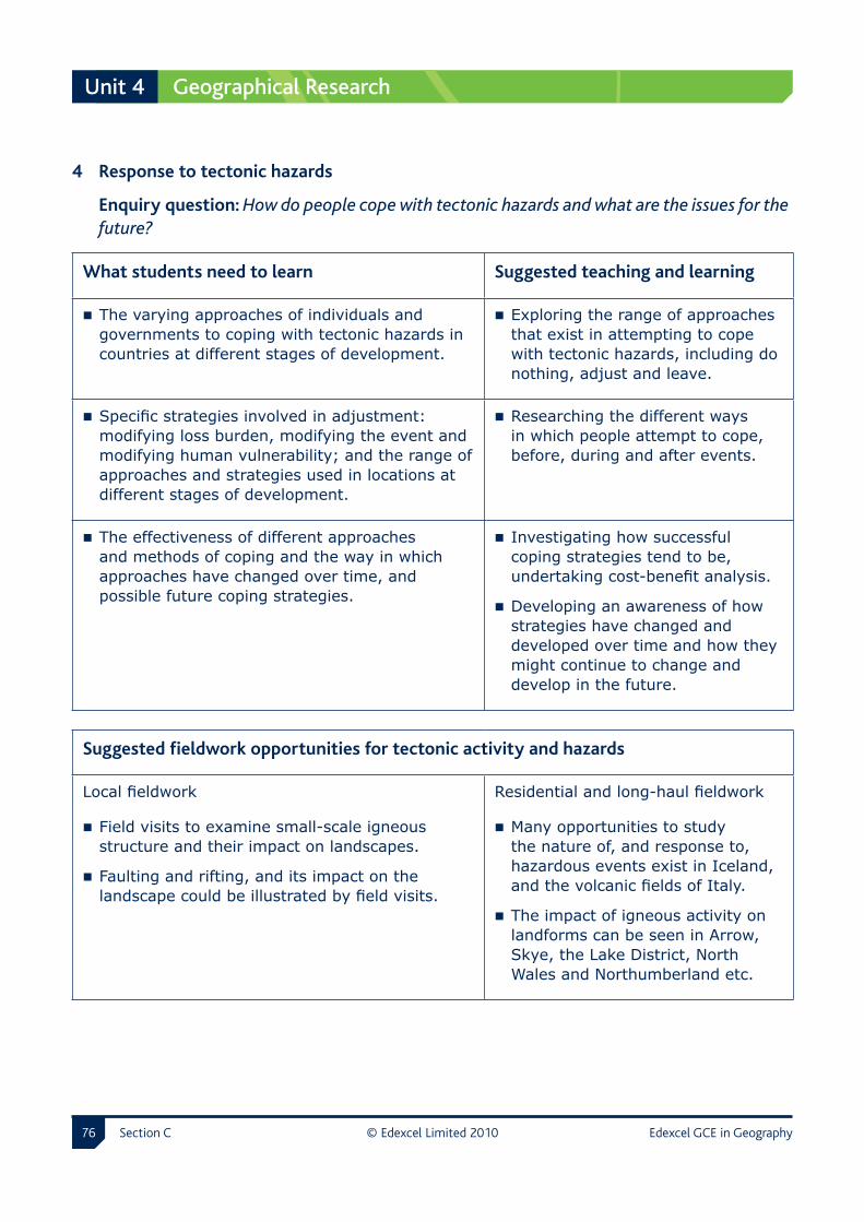
Section C © Edexcel Limited 20�0 Edexcel GCE in Geography��
Unit 4 Geographical Research
4 � Response �to �tectonic �hazards
Enquiry �question: How do people cope with tectonic hazards and what are the issues for the future?
What �students �need �to �learn Suggested �teaching �and �learning
The varying approaches of individuals and governments to coping with tectonic hazards in countries at different stages of development.
Exploring the range of approaches that exist in attempting to cope with tectonic hazards, including do nothing, adjust and leave.
Specific strategies involved in adjustment: modifying loss burden, modifying the event and modifying human vulnerability; and the range of approaches and strategies used in locations at different stages of development.
Researching the different ways in which people attempt to cope, before, during and after events.
The effectiveness of different approaches and methods of coping and the way in which approaches have changed over time, and possible future coping strategies.
Investigating how successful coping strategies tend to be, undertaking cost-benefit analysis.
Developing an awareness of how strategies have changed and developed over time and how they might continue to change and develop in the future.
Suggested �fieldwork �opportunities �for �tectonic �activity �and �hazards
Local fieldwork
Field visits to examine small-scale igneous structure and their impact on landscapes.
Faulting and rifting, and its impact on the landscape could be illustrated by field visits.
Residential and long-haul fieldwork
Many opportunities to study the nature of, and response to, hazardous events exist in Iceland, and the volcanic fields of Italy.
The impact of igneous activity on landforms can be seen in Arrow, Skye, the Lake District, North Wales and Northumberland etc.

Edexcel GCE in Geography © Edexcel Limited 20�0 Section C ��
Geographical Research Unit 4
4.4 Option 2: Cold Environments – Landscapes and Change
Cold �environments Cold environments include glacial uplands, high latitude ice-bound regions and periglacial areas. The distribution of these regions has changed significantly during the Quaternary geological period, and continues to change today. Climate determines the location of cold environments, and climate cycles have influenced the location of cold environments in the past. Much of the landscape richness in the British Isles and elsewhere is a result of past and present geomorphological processes operating in cold environments; present day study of the landscape can reveal evidence of past processes, and the same processes can be found forming landscapes today.
Management �and �protection
Cold environments present humans with both challenges and opportunities, in the form of hazards and resources. It is increasingly recognised that cold environments are under threat from human actions and require management and protection.
Global �synoptic �context
Key linkages
Places Where are cold environments today?
People How populated are cold environments, and by whom?
Power Who is involved in managing the threats facing cold environments today?
Suggested teaching and learning
Mapping the distribution of cold environments towards the poles, and in mountainous areas.
Using the internet to search for images of indigenous people and economic activities in cold environments.
Briefly examining an area, such as Antarctica, to investigate who manages it.
Section C © Edexcel Limited 20�0 Edexcel GCE in Geography��
Unit 4 Geographical Research
1 � Defining �and �locating �cold �environments
Enquiry �question: What are cold environments and where are they found?
What �students �need �to �learn Suggested �teaching �and �learning
Cold environments, glacial environments and periglacial environments.
Researching cold environments and becoming aware that not all cold environments are the same.
The concepts of landscape systems, glacial systems, mass balance, frequency/magnitude, equifinality and dynamic equilibrium.
Investigating the differences between glacial and periglacial environments and between high latitude and high altitude glacial environments.
The varying nature of different cold environments.
Investigating how the distribution of cold environments has changed over time and is still changing today.
The past and present day distribution of cold environments, with particular reference to the British Isles.
Developing awareness of the broad pattern of Britain’s glacial and interglacial history and in particular the location of the glacial and periglacial environments during the most recent glacial periods of the Quaternary.
2 � Climatic �processes �and �their �causes
Enquiry �question: What are the climatic processes that cause cold environments and what environmental conditions result from these?
What �students �need �to �learn Suggested �teaching �and �learning
The climatic causes of cold environments, eg global atmospheric circulation, Polar anticyclones, the influence of latitude and altitude upon climate, day/night, seasons etc.
Researching the varying climatic causes of cold environments in contrasting locations.
Edexcel GCE in Geography © Edexcel Limited 20�0 Section C ��
Geographical Research Unit 4
Long-term global climate change leads to changes in the distribution of cold environments.
Weighing up past, present and future changes in global climate and how these affect cold environments.
The meteorological processes associated with cold climates in different types of cold environment, including extremes of temperature, winds and the nature of precipitation.
Investigating the significance of precipitation and wind, as well as temperature, in contributing to the distinctive features of cold climates.
The spatial and temporal relationships between glacial and periglacial environments.
Exploring the relationships between the locations of glacial and periglacial environments, both in the present and the past, with particular reference to the British Isles.
3 � Distinctive �landforms �and �landscapes
Enquiry �question: How do geomorphological processes produce distinctive landscapes and landforms in cold environments?
What �students �need �to �learn Suggested �teaching �and �learning
The role of geomorphological processes in glacial environments. This should include both the action of ice and sub-aerial processes.
Examining the range of geomorphological processes that operate in different cold environments and linking these to the distinctive landscapes and landforms produced
The distinctive landforms produced by these processes in different glacial (upland and lowland) environments, including relict landforms produced in the past.
Developing an awareness that ice sheets and valley glaciers have very different landscape impacts.
The role of geomorphological processes in periglacial environments. This should include both above and below ground processes.
Investigating the differences between upland and lowland glacial landscapes and landforms.

Section C © Edexcel Limited 20�0 Edexcel GCE in Geography�0
Unit 4 Geographical Research
The distinctive landforms produced by these processes in periglacial environments, including relict landforms produced in the past.
Investigating the impact of the processes during past glacial and periglacial periods when studying present-day landscapes in Britain.
4 � Challenges �and �opportunities
Enquiry �question: What challenges and opportunities exist in cold environments and what management issues might result from their use?
What �students �need �to �learn Suggested �teaching �and �learning
The terms challenges and opportunities and explore the link between them.
Developing an awareness of the terms challenges and opportunities and understanding the link between them.
The challenges and opportunities of cold environments, including those of the present and the past.
Researching the wide range of challenges (relief, climate, avalanches, surges, meltwater floods, ground conditions, fragile ecosystems etc) and opportunities (tourism, HEP, water supply, mineral resources, etc) in different cold environments.
Cold environments in which humans are attempting to take the opportunities available by overcoming the challenges. These should include both glacial and periglacial environments.
Investigating how changes in demand and technology could lead to challenges being overcome from examples of a range of cold environments.
The effectiveness of different approaches to using and managing cold environments, considering the attitudes of different groups (residents, government, pressure groups, business/industry) and the conflicts that can exist between them.
Researching the values and attitudes of the different interest groups involved in the use and management of cold environments and examining the different approaches that can be taken to management; such as protection/conservation and sustainable management, should it be deemed necessary.

Edexcel GCE in Geography © Edexcel Limited 20�0 Section C ��
Geographical Research Unit 4
Suggested �fieldwork �opportunities �for �cold �environments �– �landscape �and �change �
Local fieldwork
Upland fieldwork to investigate glacial processes and the past distribution of glacial landscapes in the UK.
Upland alpine environments could be investigated in terms of fragility and threats.
Residential and long-haul fieldwork
Both the Alps and Pyrennes afford good opportunities for the study of the full range of a processes. Norway and Iceland would also be excellent locations for extended fieldwork.
4.5 Option 3: Life on the Margins: the Food Supply Problem
Life �on �the �margins Significant numbers of people live a life on the margin, in a situation of food insecurity. Others consume more than their fair share of global resources. This option explores this inequality, focusing on regions where food production is a continual challenge. The ‘margins’ may be traditional areas of famine, but also rapidly urbanising areas where food is scarce and malnutrition an ever present threat.
Food �insecurity The causes of food insecurity are complex, ranging from physical processes of land degradation and desertification, exacerbated by human over-exploitation, to population pressure and political processes. Increasing food supply represents a key challenge cemented with the Millennium Development Goals. However, often agreement does not exist on the best way to achieve this; options range from reforming trade systems to hi-tech farming, intermediate technology and organic farming.
Section C © Edexcel Limited 20�0 Edexcel GCE in Geography�2
Unit 4 Geographical Research
Global �synoptic �context
Key linkages
Places Where are the ‘margins’?
People Who suffers from food insecurity and over-nutrition?
Power Which organisations and groups are involved in ensuring food security?
Suggested teaching and learning
Mapping the distribution of countries suffering from food insecurity, and those facing the obesity threat.
Contrasting the socio-economic profiles of countries at different end of the food supply spectrum.
Briefly investigating the role of UN bodies such as the FAO, and NGOs such as Practical Action.
1 � Global �and �local �feast �or �famine
Enquiry �question: What are the characteristics of food supply and security?
What �students �need �to �learn Suggested �teaching �and �learning
Current issues associated with food supply and security; such as food miles, famine, globalisation of food tastes, under and over nutrition.
Exploring the current socio-economic issues associated with feeding people globally and locally.
The environmental issues resulting from food production.
Developing an awareness of inappropriate farming techniques and their impact on the environment.
Why food supply varies spatially. Investigate how current patterns of food supply and security vary at different scales in rural and urban environments.
What life on the margins means to differing people and the role of food security in the overall quality of life there.
Developing an awareness that life on the margins of survival ranges from traditionally perceived areas of famine such as the Sudan to megacities where poverty has impacts on food supply and consumption.

Edexcel GCE in Geography © Edexcel Limited 20�0 Section C ��
Geographical Research Unit 4
2 � The �complex �causes �of �food �supply �inequalities
Enquiry �question: What has caused global inequalities in food supply and security?
What �students �need �to �learn Suggested �teaching �and �learning
The complex interlinking and overlapping causes of famine and food surpluses and classification of the environmental, social and economic causes into long- and short-term, direct and indirect causes.
Investigating how and why areas of food surplus and famine have emerged.
The role of population pressure in creating food insecurity.
Weighing up the contrasting viewpoints on population pressure as highlighted by neo-Malthusians versus technocentric followers of Boserup.
The impacts of attempts to increase global food supply.
Researching food production techniques which have been environmentally damaging and contrasting these with more environmentally friendly production methods such as LEAF and organic schemes in locations as diverse as the UK, Cuba, China and Africa.
Who has been most affected by food insecurity, and why.
Investigating the nature of groups of people vulnerable to food insecurity.
3 � Desertification �and �life �at �the �margin �of �survival
Enquiry �question: What is the role of desertification in threatening life at the margins?
What �students �need �to �learn Suggested �teaching �and �learning
Desertification and its scale and impact. Developing an awareness that desertification is a type of land degradation and investigating the varying human activities and climatic variations causing it.

Section C © Edexcel Limited 20�0 Edexcel GCE in Geography��
Unit 4 Geographical Research
The scale and characteristics and vulnerability of dryland ecosystems.
Investigating the specific ecosystems, climate and hydrology of drylands to establish the physical causes of risk and vulnerability.
Why drylands are extremely vulnerable to over-exploitation and inappropriate land use.
Categorising and investigating the human factors causing vulnerability (socio-political and economic).
The relationship between food production and supply in desertified regions.
Researching how food supply is affected by desertification and conversely how food supply methods can cause desertification such as salinisation.
4 � The �role �of �management �in �food �supply �and �security
Enquiry �question: How effective can management strategies be in sustaining life at the margins?
What �students �need �to �learn Suggested �teaching �and �learning
Management techniques and strategies that have attempted to increase global food supply and security.
Researching why management strategies are not just focused on food production but fair trade and distribution and even the politics and stability of an area.
The sources of these developments and why greater international efforts are increasingly needed.
Developing an awareness that several alternative strategies exist for providing secure global food supplies; some are technology-dependent, others are low-cost (eg intermediate technology) while others may be focused upon the environment eg, organic farming.

Edexcel GCE in Geography © Edexcel Limited 20�0 Section C ��
Geographical Research Unit 4
Initiatives that have been most effective in sustaining life at the margins.
Weighing up the range and role of organisations involved in marginal food supply areas (government, business, NGOs and increasingly international organisations such as the United Nations Environment Programme).
The role of sustainable strategies in food supply and security.
Investigating a range of strategies that are designed to be sustainable, such as assessing the potential of fair trade, organic farming or of the aquaculture in sustaining life at the margins of society.
Suggested �fieldwork �opportunities �for �life �on �the �margins: �the �food �supply �problem �
Local fieldwork
Investigating issues of sourcing of food including local sourcing eg for supermarkets, farm shops and catering establishments.
Visits to contrasting local farms including organic, LEAF schemes.
Fair trade surveys.
Residential and long-haul fieldwork
Areas such as Morocco can provide studies of life at the margin and desertification.
American west could provide studies of dry land management.
4.6 Option 4: The World of Cultural Diversity
Culture Culture is a complex concept, with multiple meanings but universal importance to human populations. In many parts of the world consumption is the dominant, but not the only, culture. Culture varies spatially and has a distinct geography, with some areas being relatively homogenous while others offer greater diversity. Large urban areas often produce diversity, which is reflected in the population, services and built environment of cities. Attitudes to cultural diversity differ, both personal and political/national.

Section C © Edexcel Limited 20�0 Edexcel GCE in Geography��
Unit 4 Geographical Research
Cultural �patterns Globalisation is seen by some as a key process in driving culture towards a global model, and media TNCs and communications technology aid this process. However, the pattern is complex and localised cultures do survive and new cultures can still be generated. Culture, to some extent, determines our attitude to the wider environment in terms of consumption, conservation, exploitation and protection. Attitudes to the environment differ between cultures; however the dominance of today’s consumer capitalism is difficult to resolve with pressing global environmental concerns.
Global �synoptic �context
Key linkages
Places How do cultural landscapes vary?
People How do cultures vary?
Power Is there a ‘global culture’?
Suggested teaching and learning
Collecting a series of photographs of urban and rural landscapes from around the world and locating these on map
Using the internet to research the factors that might have led to these different cultural landscapes
Examining websites, such as McDonalds and mapping the distribution of outlets.
1 � Defining �culture �and �identifying �its �value
Enquiry �question: What is the nature and value of culture in terms of peoples and places?
What �students �need �to �learn Suggested �teaching �and �learning
Definitions of culture, in terms of human cultures (ethnicities, beliefs, histories) and places (the production of cultural landscapes); the complex origins of the word ‘culture’.
Exploring different definitions of culture and the reasons why culture is such a complex concept, which is challenging to define.
Edexcel GCE in Geography © Edexcel Limited 20�0 Section C ��
Geographical Research Unit 4
There is a range of human cultures and a variety of cultural landscapes linked to these, which continually change and evolve.
Investigating the range of human cultures, their shared characteristics, attitudes, beliefs and values, and the links between culture and landscape; via contrasting examples of traditional cultural landscapes versus post-modern technoscapes and ethnoscapes for instance.
Some cultures and landscapes are more vulnerable than others from environmental, socio-economic and political pressures.
Investigating the threats for instance erosion/destruction of landscapes and culture via political actions (Tibet) or socio-economic pressures (tourism in Bhutan; post-productivist EU landscapes).
The cultural diversity of people and places is valued, and protected, to different degrees by different players. An in-depth study of culture and its landscape should be used to illustrate this variation.
Examining the value placed on diversity by different players and groups, and exploring the reasons for their concepts of value through examples such as Wales.
2 � The �geography �of �culture
Enquiry �question: How and why does culture vary spatially?
What �students �need �to �learn Suggested �teaching �and �learning
Some countries and regions are culturally more homogenous than others, for instance Japan and Iceland in contrast with the UK; both human and physical factors help explain this.
Developing an understanding of how factors such as geographical isolation and rates of social and economic development have influenced degrees of cultural diversity.
Human cultural diversity is usually greatest in cities and in many societies there is a clear urban/rural cultural divide.
Investigating how and why urban areas are frequently cultural gateways (eg London or Los Angeles), that have greater cultural diversity than surrounding rural areas.
Section C © Edexcel Limited 20�0 Edexcel GCE in Geography��
Unit 4 Geographical Research
Government and other players’ attitudes, both positive and negative, towards human diversity and landscape diversity, are important in preserving diversity or moving towards cultural homogeneity.
Weighing up the role of governments and other players through contrasting case studies, such as Tibet, versus the preservation of landscapes in Israel.
On a global scale, cultural imperialism (‘McDonaldisation’ and other similar processes) is an important but not yet complete process affecting both human cultural diversity and the production of landscapes.
Examining the mechanisms of cultural imperialism, and the counter-cultures and movements which work against it, such as movements in France and the Arab world.
3 � The �impact �of �globalisation �on �cultural �diversity
Enquiry �question: How is globalisation impacting on culture?
What �students �need �to �learn Suggested �teaching �and �learning
Views vary greatly as to the significance of globalisation on cultural diversity.
Contrasting the variety of opinions from the pessimistic hyperglobalisers through to the sceptics.
The role of the global media corporations is important in conveying dominant cultural values and attitudes, and influencing cultural globalisation.
Examining the dominant world view that media corporations, such as Disney and Viacom convey, and how these may conflict with local values.
Cultural globalisation often takes place in local contexts thus giving rise to distinctive hybrid, globalised forms of fashion, music and film.
Investigating the variety of localised forms of culture, such as Bollywood, and the emergence of new forms of expression such as internet language, blogs and interactive web media.
There are many different opinions about the impact of a globalised consumerist society on the culture of peoples and landscapes.
Investigating the impacts of consumerism, both positive and negative, on peoples and their landscapes.
Edexcel GCE in Geography © Edexcel Limited 20�0 Section C ��
Geographical Research Unit 4
4 � Cultural �attitudes �to �the �environment
Enquiry �question: How do cultural values impact on our relationship with the environment?
What �students �need �to �learn Suggested �teaching �and �learning
Different cultures have developed different definitions of, and attitudes to, the environment.
Exploring differences in the relationship between humans and nature using a range of societies and political ideologies.
These different attitudes affect the way in which the landscape is valued in terms of exploitation and protection.
Investigating why different cultural values affect human’s use of the environment; and how key terms, such as sustainability, are defined differently according to cultural norms.
Anthropocentric cultural values are necessary to support and justify consumer cultures.
Examining how continued, growing consumption (as in modern China) requires humans to see themselves as dominant over physical and ecological aspects of the broader cultural landscape.
There is a clear conflict between environmentalism and consumer capitalism. Various cultural devices have emerged to attempt to resolve this conflict, for instance the ‘green’ movement.
Investigating the uneasy relationship between the culture of consumerism and concerns about biodiversity loss, global warming and environmental change.
Suggested �fieldwork �opportunities �for �the �world �of �cultural �diversity �
Local fieldwork
Urban fieldwork in a major city, exploring the cultural characteristics of areas with distinct ethnicities.
Cultural landscapes in the UK could be compared, for instance the in Wales, Cornwall and the Western Isles.
Cultural globalisation may be investigated in world cities such as London.
Residential and long-haul fieldwork
Relatively close areas have very distinct cultural landscapes, such as Catalonia and the Basque country, Brittany or border zones in Ireland/Wales.
There may be opportunities for exchange visits to places further afield, such as China or Africa and these are to be encouraged.

Section C © Edexcel Limited 20�0 Edexcel GCE in Geography�0
Unit 4 Geographical Research
4.7 Option 5: Pollution and Human Health at Risk
Pollution �and �human �health
Human health is a key concern at scales ranging from personal to global. Personally health has a key impact on quality of life, but it also affects economic development at broader scales and poses key global challenges relating to the spread of disease. Health risk is strongly related to level of economic development, either in the form of transmissible disease or environmental pollution. The spread of risk follows geographical patterns and features. In modern societies, pollution is a key risk especially in countries where rapid economic development takes precedence over environmental and health concerns.
Risk A wide range of strategies can be adopted to manage pollution and health; some problems are harder to manage than others and require long-term strategies, economic and lifestyle changes. Increasingly management is international in nature, reflecting an interconnected world.
Global �synoptic �context
Key linkages
Places Where are the polluted and unhealthy places?
People Who suffers as a result of pollution and health risk?
Power Who is responsible for managing these risks?
Suggested teaching and learning
Mapping areas of air pollution at a global scale, and areas at risk from disease, eg malaria and TB.
Exploring the link between pollution, health and development using a global statistics website such as the World Resources Institute.
Examining the role of a UN organisation such as the WHO.

Edexcel GCE in Geography © Edexcel Limited 20�0 Section C ��
Geographical Research Unit 4
1 � Defining �the �risks �to �human �health
Enquiry �question: What are the health risks?
What �students �need �to �learn Suggested �teaching �and �learning
Human health risks. Exploring a range of health risks from short term to chronic.
Patterns of health risk at different scales (global, national, local).
Researching the different geographical patterns of health and disease at different scales.
Health risk patterns over time. Investigating how these health risks may alter over time, as shown in the epidemiology model.
How health affects both the quality of life and economic development.
Developing an awareness of the importance of health to the overall quality of life of people and the economic development of areas/nations and the impacts of poor health.
2 � The �complex �causes �of �health �risk
Enquiry �question: What are the causes of health risks?
What �students �need �to �learn Suggested �teaching �and �learning
The complex causes of health risks. Investigating the different causes of health risk, including pollution.
The relationship between socio-economic status and health.
Researching how closely linked health patterns are with spatial variations in economic standards of living.

Section C © Edexcel Limited 20�0 Edexcel GCE in Geography�2
Unit 4 Geographical Research
The links between some diseases and geographical features.
Developing an awareness of how factors such as geographical distance and socio-economic status may greatly influence access to health care globally, nationally and/or at small scales.
Exploring how the development and spread of infection are often linked to geographical features (eg transport routes, accessibility, environment, water quality) and may follow geographical pathways and patterns.
Models that may help in the understanding of health risk causes and patterns.
Models, such as diffusion models, may help in understanding these causes and patterns.
3 � Pollution �and �health �risk
Enquiry �question: What is the link between health risk and pollution?
What �students �need �to �learn Suggested �teaching �and �learning
The link between different pollution types and the health of societies.
Researching the differing types and sources of pollution and the direct threats and effects on health, as well as indirect effects to any society economically.
The relative health risks associated with incidental and sustained pollution.
Weighing up the difference to any society’s health between one-off incidents such as Bhopal, Chernobyl and Harbin; and longer-term sustained pollution such as ozone depletion and skin cancer, and global warming and malaria spread.

Edexcel GCE in Geography © Edexcel Limited 20�0 Section C ��
Geographical Research Unit 4
The link between pollution, economic development and changing health risks.
Examining how types and amounts of pollution change with economic development and how, for example, the Kuznet curve and epidemiological models can assist in explaining these factors.
The role of pollution fatigue in reducing health risk.
Investigating the link between pollution fatigue and the backlash from the public to pressurise for effective management.
4 � Managing �the �health �risk
Enquiry �question: How can the impacts of health risk be managed?
What �students �need �to �learn Suggested �teaching �and �learning
The socio-economic and environmental impacts of health risk.
Investigating the varying impact of infection and disease on people and communities and the resultant short- and long-term economic burdens on society.
How health risk impacts have led to differing management strategies and policies.
Developing an awareness of why some health risks and environments are harder to manage than others; such as indirect spin-offs from modern societies and consumerism like depression, obesity and diabetes.
The different agencies involved in health risk, especially international efforts.
Examining the increasing role of international agencies (official TNCs and NGOs) in managing health risk and pollution.

Section C © Edexcel Limited 20�0 Edexcel GCE in Geography��
Unit 4 Geographical Research
Which health risks can be managed effectively and which cannot; and the role of sustainability.
Researching the needs for longer-term sustainable planning for a better health environment; while shorter-term planning may also be necessary in some circumstances. Contrasting scenarios such as AIDs and emergency disease relief could be used.
Suggested �fieldwork �opportunities �for �pollution �and �human �health �at �risk
Local fieldwork
Using GIS and primary surveys to look at patterns of mortality, morbidity and disease and the causal factors at a local scale and inequality of access to health care.
Surveys of selected diseases and problems, eg drug addiction, obesity, cancer, to study patterns of occurrence ie introduction to epidemiology.
Surveys of types of pollution eg water, air etc using primary and secondary data to identify areas of risk.
Residential and long-haul fieldwork
LEDC fieldwork could include surveys of health issues and health care access, for example in Morocco, Kenya etc.
Fieldwork in distant locations to assess levels of pollution (land, air, water, noise, visual etc) for example in large urban areas or within a river catchment, or coastally, for example in Poland (acid rain impact survey).
4.8 Option 6: Consuming the Rural Landscape – Leisure and Tourism
Consumption Increasingly, landscapes are undergoing a structural shift from production to consumption; in other words from primary production towards tourism and leisure. This shift affects rural landscapes of all types from the accessible rural-urban fringe to remote regions, increasingly, the locations of consumption are global and few areas remain untouched by leisure and tourism. This consumption puts pressure on often fragile rural landscapes, and represents a threat that requires careful management.

Edexcel GCE in Geography © Edexcel Limited 20�0 Section C ��
Geographical Research Unit 4
Reconciling �the �demands
Rural areas and landscapes can both benefit from increasing use for leisure and tourism, and can also be threatened by it. Reconciling the demands of consumers with the need to protect rural landscapes is a key challenge, which can be tackled in a wide variety of ways from preservation to ecotourism.
Global �synoptic �context
Key linkages
Places Where are rural areas and what are they like?
People Who lives in, and visits, rural areas?
Power Who manages the threats facing rural areas?
Suggested teaching and learning
Mapping the distribution of different rural areas in the UK or USA
Using photographs of UK and world rural areas and contrasting them in terms of degree of leisure and tourism use
Examining the role of an organisation such as the US National Parks Service
1 � The �growth �of �leisure �and �tourism �landscapes
Enquiry �question: What is the relationship between the growth of leisure and tourism and rural landscape use?
What �students �need �to �learn Suggested �teaching �and �learning
The rise of leisure and tourism and the spread of the pleasure periphery for active and passive pursuits.
Developing awareness of the global growth in leisure and tourism and investigating the reasons for it, including globalisation.
The range of rural landscapes, from urban fringe to wilderness, sought for leisure and tourism activities.
Examining the wide range of different uses that leisure and tourism activities make of rural landscapes and the recent growth in such activities.

Section C © Edexcel Limited 20�0 Edexcel GCE in Geography��
Unit 4 Geographical Research
The attitudes of different groups of people involved in this relationship: governments, intergovernmental agencies, businesses, pressure groups, communities and individuals.
Research into the different groups of people involved who have different values and attitudes to rural landscape use.
How different leisure and tourism activities in rural landscapes may lead to conflicts.
Developing an awareness that different activities in the same area may lead to conflicts in the use of rural landscapes.
2 � The �significance �and �fragility �of �rural �landscapes
Enquiry �question: What is the significance of some rural landscapes used for leisure and tourism?
What �students �need �to �learn Suggested �teaching �and �learning
The physical significance and ecological value of some rural landscapes.
Developing an awareness of the ecological and physical value and fragility.
How rural settlements may be classed as fragile landscapes.
Researching the complex linkages within naturally functioning natural ecosystems in a wilderness and human made systems at the urban fringe or in rural settlements.
The degree of threat to rural landscapes by using models such as the carrying capacity model and the resilience model.
Being able to apply models – such as the carrying capacity model or resilience model – and assessing their usefulness.
The use of qualitative and quantitative environmental quality measures, and their usefulness, for example in designating protected areas such as National Parks.
Investigating the range of qualitative and quantitative methods; and the criteria used in measuring the quality of rural environments and their usefulness.

Edexcel GCE in Geography © Edexcel Limited 20�0 Section C ��
Geographical Research Unit 4
3 � Impact �on �rural �landscapes
Enquiry �question: What impact does leisure and tourism have on rural landscapes?
What �students �need �to �learn Suggested �teaching �and �learning
The range of negative impacts leisure and tourism has on rural landscapes, such as trampling, pollution, erosion, habitat disturbance.
Investigating the wide range of negative impacts that leisure and tourism activities can have on rural landscapes.
The range of positive impacts leisure and tourism has on rural landscapes, such as wildlife conservation, river restoration, conservation of heritage sites.
Investigating the wide range of positive impacts that leisure and tourism activities can have on rural landscapes.
Ways in which impacts can change over time as the nature and level of use varies.
Researching the impacts that may change over time and the reasons for such changes.
The threats and opportunities posed in areas of differing economic development.
Developing awareness that as the pleasure periphery expands and disposable income increases globally, tourism hotspots are found in all economic groupings, so increasing numbers of areas experience both positive and negative impacts.
4 � Rural �landscape �management �issues
Enquiry �question: How can rural landscapes used for leisure and tourism be managed?
What �students �need �to �learn Suggested �teaching �and �learning
Whether rural landscapes should be managed or not.
Investigating the arguments for and against the management of rural landscapes.
Section C © Edexcel Limited 20�0 Edexcel GCE in Geography��
Unit 4 Geographical Research
The range of different management strategies including preservation, conservation, stewardship, sustainable management and the growth of ecotourism.
Developing an awareness that there are a range of management options and that there are advantages and disadvantages of each including the concept of mitigation.
The attitudes and strategies of different groups (residents, government, pressure groups, business/industry) and the conflicts that can exist between them.
Developing an awareness about the nature of conflict between different landscape users and managers and why conflict has arisen.
The effectiveness of different approaches to managing rural environments.
Examining a range of different management strategies as applied to different locations.
Suggested �fieldwork �opportunities �for �consuming �the �rural �landscape �– �leisure �and �tourism
Local fieldwork
An in-depth fieldstudy of tourism types and its impacts along a continuum from the rural urban fringe to a wildscape.
A study of a national park to identify conflicts and management methods
Research into the fragility of a rural landscape, and the threats facing it, used for recreation.
Residential and long-haul fieldwork
Many areas, both in Europe and further afield could be studied in depth.
Examples include the Alps, the coastal resorts of France and Spain (which often inter-mingle with protected areas), as well as the National Parks of the USA.

Edexcel GCE in Geography © Edexcel Limited 20�0 Section D ��
D Assessment and additional information
Assessment information
Assessment �requirements
For a summary of assessment requirements and assessment objectives, see Section B Specification overview.
Entering �candidates �for �this �qualification
Details of how to enter candidates for the examinations for this qualification can be found in Edexcel’s Information Manual, copies of which are sent to all examination officers. The information can also be found on Edexcel’s website: www.edexcel.com
Resitting �of �units � There is no limit to the number of times that a student may retake a unit prior to claiming certification for the qualification. The best available result for each contributing unit will count towards the final grade.
After certification all unit results may be reused to count towards a new award. Students may re-enter for certification only if they have retaken at least one unit.
Results of units held in the Edexcel unit bank have a shelf life limited only by the shelf life of this specification.
Awarding �and �reporting
The grading, awarding and certification of this qualification will comply with the requirements of the current GCSE/GCE Code of Practice for courses starting in September 2008, which is published by the Qualifications and Curriculum Authority. The AS qualification will be graded and certificated on a five-grade scale from A to E. The full GCE Advanced level will be graded on a six-point scale A* to E. Individual unit results will be reported.
A pass in an Advanced Subsidiary subject is indicated by one of the five grades A, B, C, D, E of which grade A is the highest and grade E the lowest. A pass in an Advanced GCE subject is indicated by one of the six grades A*, A, B, C, D, E of which Grade A* is the highest and Grade E the lowest. To be awarded an A* students will need to achieve an A on the full GCE Advanced level qualification and an A* aggregate of the A2 units. Students whose level of achievement is below the minimum judged by Edexcel to be of sufficient standard to be recorded on a certificate will receive an unclassified U result.
Performance �descriptions
Performance descriptions give the minimum acceptable level for a grade. See Appendix 1 for the performance descriptions for this subject.

D Assessment and additional information
Section D © Edexcel Limited 20�0 Edexcel GCE in Geography�00
Unit �results � The minimum uniform marks required for each grade for each unit are:
Unit 1 and Unit 3
Unit grade A B C D E
Maximum uniform mark = 120 96 84 72 60 48
Candidates who do not achieve the standard required for a grade E will receive a uniform mark in the range 0–47.
Unit 2 and Unit 4
Unit grade A B C D E
Maximum uniform mark = 80 64 56 48 40 32
Candidates who do not achieve the standard required for a grade E will receive a uniform mark in the range 0–31.
Qualification �results
The minimum uniform marks required for each grade:
Advanced Subsidiary Cash-in code 8GE01
Qualification grade A B C D E
Maximum uniform mark = 200 160 140 120 100 80
Candidates who do not achieve the standard required for a grade E will receive a uniform mark in the range 0–79.
Advanced GCE Cash-in code 9GE01
Qualification grade A B C D E
Maximum uniform mark = 400 320 280 240 200 160
Candidates who do not achieve the standard required for a grade E will receive a uniform mark in the range 0–159.

Assessment and additional information D
Edexcel GCE in Geography © Edexcel Limited 20�0 Section D �0�
Language �of �assessment
Assessment of this specification will be available in English only. Assessment materials will be published in English only and all work submitted for examination and moderation must be produced in English.
Quality �of �written �communication
Students will be assessed on their ability to:
write legibly, with accurate use of spelling, grammar and punctuation in order to make the meaning clear
select and use a form and style of writing appropriate to purpose and to complex subject matter
organise relevant information clearly and coherently, using specialist vocabulary when appropriate.
D Assessment and additional information
Section D © Edexcel Limited 20�0 Edexcel GCE in Geography�02
Assessment �objectives �and �weighting �
% in AS % in A2% in GCE
AO1Demonstrate knowledge and understanding of the content, concepts and processes.
60% 40% 50%
AO2Analyse, interpret and evaluate geographical information, issues and viewpoints and apply understanding in unfamiliar contexts.
24% 26% 25%
AO3
Select and use a variety of methods, skills and techniques (including the use of new technologies) to investigate questions and issues, reach conclusions and communicate findings.
16% 34% 25%
TOTAL 100% 100% 100%
Synoptic �assessment
In synoptic assessment there should be a concentration on the quality of assessment to ensure that it encourages the development of the holistic understanding of the subject.
Synopticity requires students to connect knowledge, understanding and skills acquired in different parts of the Advanced GCE course.
Synoptic assessment in the context of geography requires students to develop an overview which links different topics from across the Advanced GCE course.
Unit 3 provides obvious synoptic assessment in the form of the Synoptic Investigation. This Synoptic Investigation looks at players, actions and futures and is assessed through essay questions totalling 40 marks out of 90 marks in the Unit 3 examination.
Unit 4 involves geographical research that is designed to expose students to a range of geographical information in a variety of forms, namely books, journals, video and the internet. Many of these will be unfamiliar in terms of context and content. Part of this holistic exploration will involve linking content and concepts from Units 1, 2 and 3 into their research.

Assessment and additional information D
Edexcel GCE in Geography © Edexcel Limited 20�0 Section D �0�
Stretch �and �challenge
Students can be stretched and challenged in A2 units through the use of different assessment strategies, for example:
using a variety of demanding stems in questions – for example analyse, evaluate, discuss, compare
a requirement for extended writing in all units
use of a wider range of question types to address different skills – for example, open-ended essays based on research
development of synoptic assessment to include a research component.
Additional information
Malpractice �and �plagiarism
For up-to-date advice on malpractice and plagiarism, please refer to the Joint Council for Qualifications – Suspected Malpractice in Examinations: Policies and Procedures document on the JCQ website www.jcq.org.uk/
Access �arrangements �and �special �requirements
Edexcel’s policy on access arrangements and special considerations for GCE, GCSE, and Entry Level aims to enhance access to the qualifications for students with disabilities and other difficulties (as defined by the Disability Discrimination Act 1995 and the amendments to the Act) without compromising the assessment of skills, knowledge, understanding or competence.
Please see the Edexcel website (www.edexcel.com) for:
the JCQ policy Access Arrangements and Special Considerations, Regulations and Guidance Relating to students who are Eligible for Adjustments in Examinations
the forms to submit for request for access arrangements and special considerations
dates for submission of the forms.
Requests for access arrangements and special considerations must be addressed to:
Special Requirements Edexcel One90 High Holborn London WC1V 7BH

D Assessment and additional information
Section D © Edexcel Limited 20�0 Edexcel GCE in Geography�0�
Disability �Discrimination �Act
Please see Appendix 7 for the Advanced GCE in Government and Politics Disability Discrimination Act information.
Prior �learning �and �progression
Prior learning
Students who would benefit most from studying a GCE in Geography are likely to have studied Level 2 qualifications which might include GCSE Geography at grades A*–C or related vocational subjects.
Progression
This qualification supports progression into further education, training or employment, such as a degree in geography.
Combinations �of �entry
There are no forbidden combinations.
Student �recruitment
Edexcel’s access policy concerning recruitment to our qualifications is that:
they must be available to anyone who is capable of reaching the required standard
they must be free from barriers that restrict access and progression
equal opportunities exist for all students.
Key �skills This qualification provides opportunities for developing and generating evidence for assessing the key skills listed below:
application of number
communication
information and communication technology
improving own learning and performance
problem solving
working with others.
Further details are available in Appendices 2 and 3.
This qualification will be mapped to functional skills once they are finalised. Information will be available on our website (www.edexcel.com/gce2008) at a later date.

Assessment and additional information D
Edexcel GCE in Geography © Edexcel Limited 20�0 Section D �0�
The �wider �curriculum
This qualification provides opportunities for developing an understanding of spiritual, moral, ethical, social and cultural issues, together with an awareness of environmental issues, health and safety considerations, and European developments consistent with relevant international agreements appropriate as applied to geography. Appendix 4: Wider curriculum maps the opportunities available.
D Assessment and additional information
Section D © Edexcel Limited 20�0 Edexcel GCE in Geography�0�
Edexcel GCE in Geography © Edexcel Limited 20�0 Section E �0�
E Resources, support and training
Resources to support the specification
In addition to the resources available in the e-Spec and in the Getting Started guide book, Edexcel produces a wide range of resources to support this specification.
Please note that while resources are checked at the time of publication, materials may be withdrawn from circulation and website locations may change. The resources listed are intended to be a guide for teachers and not a comprehensive list.
Edexcel’s own published resources
Edexcel aims to provide the most comprehensive support for our qualifications. We have therefore published our own dedicated suite of resources for teachers and students written by qualification experts. The resources include:
AS Students’ Book
A2 Students’ Book
AS Teacher’s File/ActiveTeach CD ROM
A2 Teacher’s File/ActiveTeach CD ROM.
For more information on our complete range of products and services for Advanced Level GCE in Geography, visit www.edexcel.com/gce2008/

E Resources, support and training
Section E © Edexcel Limited 20�0 Edexcel GCE in Geography�0�
Edexcel publications
You can order further copies of the specification and specimen examination documents from:
Edexcel Publications Adamsway Mansfield Notts NG18 4FN
Telephone: 01623 467467 Fax: 01623 450481 Email: [email protected] Website: www.edexcel.com
Additional resources endorsed by Edexcel
Edexcel also endorses additional materials written to support this qualification. Any resources bearing the Endorsed by Edexcel logo have been through a rigorous quality assurance process to ensure complete and accurate support for the specification. For up-to-date information about endorsed resources, please visit www.edexcel.com/endorsed
Please note that while resources are checked at the time of publication, materials may be withdrawn from circulation and website locations may change.
The resources listed are intended to be a guide for teachers and not a comprehensive list. Further suggestions can be found in Appendix 6.
Please see www.edexcel.com for up-to-date information.

Resources, support and training E
Edexcel GCE in Geography © Edexcel Limited 20�0 Section E �0�
Support
Edexcel �support �services
Edexcel has a wide range of support services to help you implement this qualification successfully.
ResultsPlus – ResultsPlus is a new application launched by Edexcel to help subject teachers, senior management teams and students by providing detailed analysis of examination performance. Reports that compare performance between subjects, classes, your centre and similar centres can be generated in ‘one-click’. Skills maps that show performance according to the specification topic being tested are available for some subjects. For further information about which subjects will be analysed through ResultsPlus, and for information on how to access and use the service, please visit www.edexcel.com
Ask the Expert – Ask the Expert is a new service, launched in 2007, that provides direct email access to senior subject specialists who will be able to answer any questions you might have about this or any other specification. All of our specialists are senior examiners, moderators or verifiers and they will answer your email personally. You can read their biographies and learn more about this unique service on our website at www.edexcel.com.
Ask Edexcel – Ask Edexcel is Edexcel’s online question and answer service. You can access it at www.edexcel.com or by going to the main website and selecting the ‘Ask Edexcel’ menu item on the left. The service allows you to search through a database of thousands of questions and answers on everything Edexcel offers. If you don’t find an answer to your question, you can choose to submit it straight to us. One of our customer services team will log your query, find an answer and send it to you. They’ll also consider adding it to the database if appropriate. This way the volume of helpful information that can be accessed via the service is growing all the time.
Examzone – The examzone site is aimed at students sitting external examinations and gives information on revision, advice from examiners and guidance on results, including re-marking, re-sitting and progression opportunities. Further services for students – many of which will also be of interest to parents – will be available in the near future. Links to this site can be found on the main homepage at www.edexcel.com

E Resources, support and training
Section E © Edexcel Limited 20�0 Edexcel GCE in Geography��0
Training
A programme of professional development and training courses, covering various aspects of the specification and examination, will be arranged by Edexcel each year on a regional basis. Full details can be obtained from:
Training from Edexcel Edexcel One90 High Holborn London WC1V 7BH
Our customer service numbers are:
GCE 0844 576 0025 GCSE 0844 576 0027 BTEC and NVQ 0844 576 0026 The Diploma 0844 576 0028 DIDA and other qualifications 0844 576 0031
Calls may be recorded for training purposes.
Email: [email protected] Website: www.edexcel.com

Edexcel GCE in Geography © Edexcel Limited 20�0 Section F ���
F Appendices
Appendix 1 Performance descriptions 113
Appendix 2 Key skills mapping 117
Appendix 3 Key skills development 119
Appendix 4 Wider curriculum 123
Appendix 5 Codes 125
Appendix 6 Glossary 127
Appendix 7 Disability Discrimination Act 129

F Appendices
Section F © Edexcel Limited 20�0 Edexcel GCE in Geography��2
Edexcel GCE in Geography © Edexcel Limited 20�0 Section F ���
Appendix 1 Performance descriptions
Introduction
Performance descriptions have been created for all GCE subjects. They describe the learning outcomes and levels of attainment likely to be demonstrated by a representative candidate performing at the A/B and E/U boundaries for AS and A2.
In practice most candidates will show uneven profiles across the attainments listed, with strengths in some areas compensating in the award process for weaknesses or omissions elsewhere. Performance descriptions illustrate expectations at the A/B and E/U boundaries of the AS and A2 as a whole; they have not been written at unit level.
Grade A/B and E/U boundaries should be set using professional judgement. The judgement should reflect the quality of candidates’ work, informed by the available technical and statistical evidence. Performance descriptions are designed to assist examiners in exercising their professional judgement. They should be interpreted and applied in the context of individual specifications and their associated units. However, performance descriptions are not designed to define the content of specifications and units.
The requirement for all AS and A level specifications to assess candidates’ quality of written communication will be met through one or more of the assessment objectives.
The performance descriptions have been produced by the regulatory authorities in collaboration with the awarding bodies.

Appendix 1 Performance descriptions
Section F © Edexcel Limited 20�0 Edexcel GCE in Geography���
AS performance descriptions for Geography
Asse
ssm
en
t o
bje
cti
ve 1
A
sse
ssm
en
t o
bje
cti
ve 2
A
sse
ssm
en
t o
bje
cti
ve 3
Asse
ssm
en
t o
bje
cti
ve
s D
em
onst
rate
know
ledge
and
unders
tandin
g o
f th
e co
nte
nt,
co
nce
pts
and p
roce
sses.
Analy
se,
inte
rpre
t and e
valu
ate
geogra
phic
al in
form
ation,
issu
es
and
view
poin
ts a
nd a
pply
unders
tandin
g
in u
nfa
mili
ar
conte
xts
.
Sele
ct a
nd u
se a
var
iety
of m
ethods,
sk
ills
and t
ech
niq
ues
(incl
udin
g t
he
use
of new
tech
nolo
gie
s) t
o in
vest
igat
e quest
ions
and iss
ues,
rea
ch
concl
usi
ons
and c
om
munic
ate
findin
gs.
A/B
b
ou
nd
ary
p
erf
orm
an
ce
de
scri
pti
on
s
Candid
ate
s ch
ara
cteri
stic
ally
:
a dem
onst
rate
deta
iled k
now
ledge
and u
nders
tandin
g o
f a
range
of
conce
pts
and p
roce
sses
b
dem
onst
rate
deta
iled k
now
ledge
and u
nders
tandin
g o
f su
bje
ct-
speci
fic
mate
rial.
Candid
ate
s ch
ara
cteri
stic
ally
:
a analy
se a
nd inte
rpre
t geogra
phic
al
info
rmation,
issu
es
and v
iew
poin
ts
b
off
er
a va
lid e
valu
ation o
f geogra
phic
al in
form
ation,
issu
es
and v
iew
poin
ts
c dem
onst
rate
the
abili
ty t
o a
pply
geogra
phic
al unders
tandin
g t
o
unfa
mili
ar
conte
xts
at
diffe
rent
scale
s.
Candid
ate
s ch
ara
cteri
stic
ally
:
a se
lect
and u
se a
ppro
pri
ate
ly
a ra
nge
of
meth
ods,
skill
s and
tech
niq
ues
(incl
udin
g n
ew
tech
nolo
gie
s) w
hen inve
stig
ating
quest
ions
and iss
ues
b
reach
valid
concl
usi
ons
and
com
munic
ate
findin
gs
clearl
y in
a
stru
cture
d m
anner
appro
pri
ate
to
the
task
.
E/U
b
ou
nd
ary
p
erf
orm
an
ce
de
scri
pti
on
s
Candid
ate
s ch
ara
cteri
stic
ally
:
a dem
onst
rate
som
e know
ledge
and
unders
tandin
g o
f so
me
conce
pts
and p
roce
sses
b
show
basi
c know
ledge
and
unders
tandin
g o
f su
bje
ct-s
peci
fic
mate
rial.
Candid
ate
s ch
ara
cteri
stic
ally
:
a off
er
limited a
nd inco
nsi
stent
analy
sis
and inte
rpre
tation o
f geogra
phic
al in
form
ation,
issu
es
and v
iew
poin
ts
b
att
em
pt
som
e lim
ited e
valu
ation o
f geogra
phic
al in
form
ation,
issu
es
and v
iew
poin
ts
c sh
ow
som
e lim
ited a
bili
ty t
o
apply
asp
ect
s of
geogra
phic
al
unders
tandin
g t
o u
nfa
mili
ar
conte
xts
.
Candid
ate
s ch
ara
cteri
stic
ally
:
a use
a lim
ited r
ange
of
meth
ods,
sk
ills
and t
ech
niq
ues
(whic
h m
ay
incl
ude
new
tech
nolo
gie
s) t
o
att
em
pt
to inve
stig
ate
quest
ions
and iss
ues
b
dra
w s
om
e lim
ited c
oncl
usi
ons
c co
mm
unic
ate
findin
gs
whic
h
bro
adly
addre
ss t
he
task
s.

Performance descriptions Appendix 1
Edexcel GCE in Geography © Edexcel Limited 20�0 Section F ���
Asse
ssm
en
t o
bje
cti
ve 1
A
sse
ssm
en
t o
bje
cti
ve 2
A
sse
ssm
en
t o
bje
cti
ve 3
Asse
ssm
en
t o
bje
cti
ve
s D
em
onst
rate
know
ledge
and
unders
tandin
g o
f th
e co
nte
nt,
co
nce
pts
and p
roce
sses.
Analy
se,
inte
rpre
t and e
valu
ate
geogra
phic
al in
form
ation,
issu
es
and
view
poin
ts a
nd a
pply
unders
tandin
g
in u
nfa
mili
ar
conte
xts
.
Sele
ct a
nd u
se a
var
iety
of m
ethods,
sk
ills
and t
ech
niq
ues
(incl
udin
g t
he
use
of new
tech
nolo
gie
s) t
o in
vest
igat
e quest
ions
and iss
ues,
rea
ch
concl
usi
ons
and c
om
munic
ate
findin
gs.
A/B
b
ou
nd
ary
p
erf
orm
an
ce
de
scri
pti
on
s
Candid
ate
s ch
ara
cteri
stic
ally
:
a dem
onst
rate
know
ledge
and
unders
tandin
g o
f a
wid
e ra
nge
of
conce
pts
and p
roce
sses
b
show
thoro
ugh k
now
ledge
and
unders
tandin
g o
f su
bje
ct -
speci
fic
mate
rial.
Candid
ate
s ch
ara
cteri
stic
ally
:
a acc
ura
tely
and c
om
pete
ntly
analy
se a
nd inte
rpre
t geogra
phic
al
info
rmation,
issu
es
and v
iew
poin
ts
b
off
er
a th
oro
ugh e
valu
ation o
f geogra
phic
al in
form
ation,
issu
es
and v
iew
poin
ts in r
ela
tion t
o
speci
fic
geogra
phic
al co
nce
pts
c dem
onst
rate
the
abili
ty t
o
apply
acc
ura
te a
nd a
ppro
pri
ate
geogra
phic
al unders
tandin
g t
o
unfa
mili
ar
conte
xts
with p
reci
sion
at
a ra
nge
of
scale
s.
Candid
ate
s ch
ara
cteri
stic
ally
:
a se
lect
and u
se a
ppro
pri
ate
ly
and a
ccura
tely
a w
ide
range
of
meth
ods,
skill
s and t
ech
niq
ues
(incl
udin
g n
ew t
ech
nolo
gie
s) w
hen
thoro
ughly
inve
stig
ating q
uest
ions
and iss
ues
b
reach
subst
antiate
d a
nd v
alid
co
ncl
usi
ons
c co
mm
unic
ate
findin
gs
acc
ura
tely
and a
ppro
pri
ate
ly t
o t
he
task
.
E/U
b
ou
nd
ary
p
erf
orm
an
ce
de
scri
pti
on
s
Candid
ate
s ch
ara
cteri
stic
ally
:
a dem
onst
rate
som
e know
ledge
and u
nders
tandin
g o
f th
e m
ain
conce
pts
and p
roce
sses
b
show
som
e unders
tandin
g o
f su
bje
ct-s
peci
fic
mate
rial.
Candid
ate
s ch
ara
cteri
stic
ally
:
a sh
ow
som
e at
tem
pts
to a
naly
se
and inte
rpre
t geogra
phic
al
info
rmation,
issu
es
and v
iew
poin
ts
with v
ary
ing d
egre
es
of
succ
ess
b of
fer
som
e ev
aluat
ion o
f geo
grap
hic
al in
form
atio
n, is
sues
and
view
poi
nts
with v
aria
ble
succ
ess
c sh
ow
som
e ab
ility
to a
pply
geogra
phic
al unders
tandin
g t
o
unfa
mili
ar
conte
xts
with s
om
e degre
e of
acc
ura
cy.
Candid
ate
s ch
ara
cteri
stic
ally
:
a use
a r
ange
of
meth
ods,
skill
s and t
ech
niq
ues
(whic
h incl
ude
new
tech
nolo
gie
s) t
o inve
stig
ate
quest
ions
and iss
ues
with v
ary
ing
degre
es
of
succ
ess
.
b
dra
w s
om
e st
raig
htf
orw
ard
co
ncl
usi
ons
c co
mm
unic
ate
findin
gs
bro
adly
appro
pri
ate
to t
he
task
.
A2 performance descriptions for Geography

F Appendices
Section F © Edexcel Limited 20�0 Edexcel GCE in Geography���
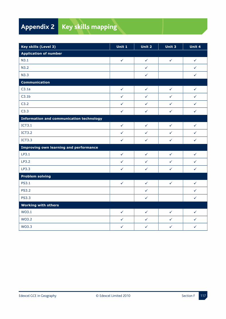
Edexcel GCE in Geography © Edexcel Limited 20�0 Section F ���
Appendix 2 Key skills mapping
Key skills (Level 3) Unit 1 Unit 2 Unit 3 Unit 4
Application of number
N3.1
N3.2
N3.3
Communication
C3.1a
C3.1b
C3.2
C3.3
Information and communication technology
ICT3.1
ICT3.2
ICT3.3
Improving own learning and performance
LP3.1
LP3.2
LP3.3
Problem solving
PS3.1
PS3.2
PS3.3
Working with others
WO3.1
WO3.2
WO3.3

F Appendices
Section F © Edexcel Limited 20�0 Edexcel GCE in Geography���
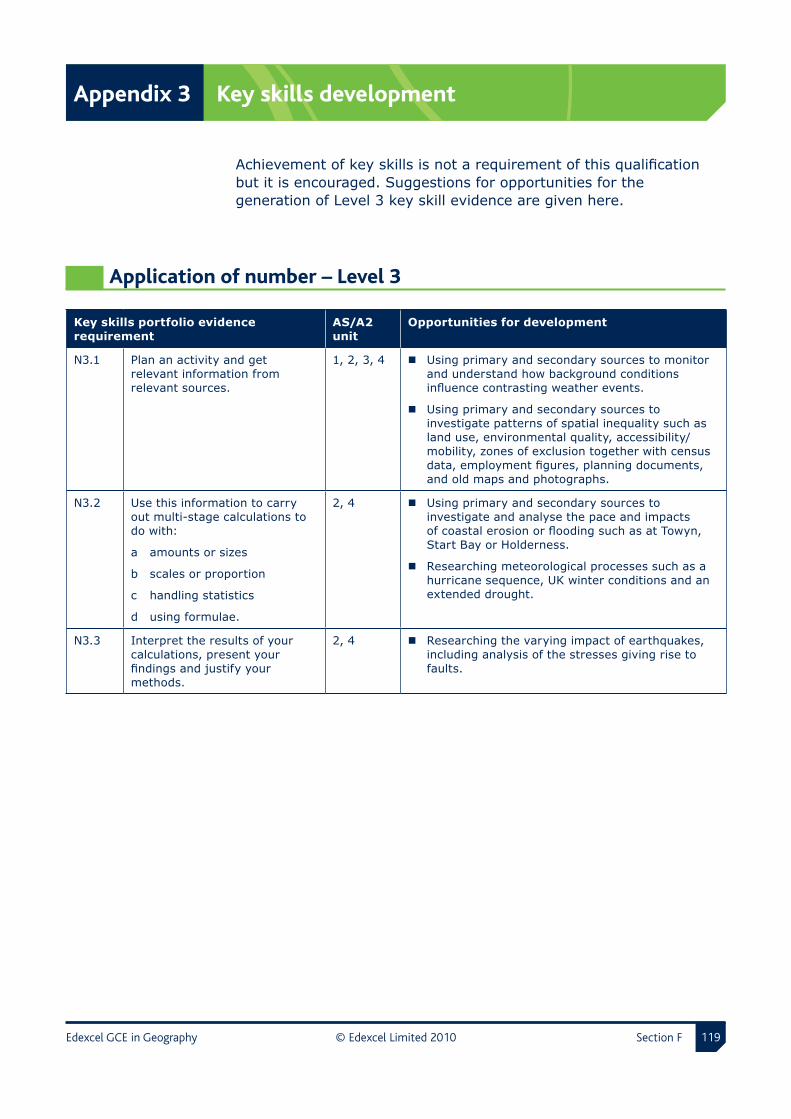
Edexcel GCE in Geography © Edexcel Limited 20�0 Section F ���
Appendix 3 Key skills development
Achievement of key skills is not a requirement of this qualification but it is encouraged. Suggestions for opportunities for the generation of Level 3 key skill evidence are given here.
Application of number – Level 3
Key skills portfolio evidence requirement
AS/A2 unit
Opportunities for development
N3.1 Plan an activity and get relevant information from relevant sources.
1, 2, 3, 4 Using primary and secondary sources to monitor and understand how background conditions influence contrasting weather events.
Using primary and secondary sources to investigate patterns of spatial inequality such as land use, environmental quality, accessibility/mobility, zones of exclusion together with census data, employment figures, planning documents, and old maps and photographs.
N3.2 Use this information to carry out multi-stage calculations to do with:
a amounts or sizes
b scales or proportion
c handling statistics
d using formulae.
2, 4 Using primary and secondary sources to investigate and analyse the pace and impacts of coastal erosion or flooding such as at Towyn, Start Bay or Holderness.
Researching meteorological processes such as a hurricane sequence, UK winter conditions and an extended drought.
N3.3 Interpret the results of your calculations, present your findings and justify your methods.
2, 4 Researching the varying impact of earthquakes, including analysis of the stresses giving rise to faults.

Appendix 3 Key skills development
Section F © Edexcel Limited 20�0 Edexcel GCE in Geography�20
Communication – Level 3
Key skills portfolio evidence requirement
AS/A2 unit
Opportunities for development
C3.1a Take part in a group discussion. 1, 2, 3, 4 Weighing up the role of governments and other players through contrasting case studies, such as Tibet versus the preservation of landscapes in Israel.
C3.1b Make a formal presentation of at least eight minutes using an image or other support material.
1, 2, 3, 4 Weighing up the difference to any society’s health between one-off incidents such as Bhopal, Chernobyl and Harbin and longer term sustained pollution such as ozone depletion and skin cancer, global warming and malaria spread.
C3.2 Read and synthesise information from at least two documents about the same subject.
Each document must be a minimum of 1000 words long.
1, 2, 3, 4 Investigating the varying impact of infection and disease on people and communities and resultant short- and long-term economic burdens on society.
C3.3 Write two different types of document, each one giving different information about complex subjects.
One document must be at least 1000 words long.
1, 2, 3, 4 Examining trends in global energy supply and demand by source, type of economy and economic sector.
Information and communication technology – Level 3
Key skills portfolio evidence requirement
AS/A2 unit
Opportunities for development or internal assessment
ICT3.1 Search for information, using different sources and multiple search criteria in at least one case.
1, 2, 3, 4 Investigating by family tree/history or records how the local population has changed.
ICT3.2 Enter and develop the information and derive new information.
1, 2, 3, 4 Investigating by family tree/history or records how the local population has changed.
ICT3.3 Present combined information such as text with image, text with number, image with number.
1, 2, 3, 4 Investigating by family tree/history or records how the local population has changed.

Key skills development Appendix 3
Edexcel GCE in Geography © Edexcel Limited 20�0 Section F �2�
Improving own learning and performance – Level 3
Key skills portfolio evidence requirement
AS/A2 unit
Opportunities for development or internal assessment
LP3.1 Set targets using information from appropriate people and plan how these will be met.
1, 2, 3, 4 Assessing the beneficial economic impacts of development against the environmental costs through a study of, for example, Dibden Bay or Sellafield.
LP3.2 Take responsibility for your learning, using your plan to help meet targets and improve your performance.
1, 2, 3, 4 Using primary and secondary resources to investigate the success of named urban schemes involving for example:
shanty builds, residents associations, neighbourhood watch schemes
congestion charging, park and ride, Oystercards.
LP3.3 Review progress and establish evidence of your achievements.
1, 2, 3, 4 Developing awareness that there are a range of management options and that there are advantages and disadvantages of each including the concept of mitigation.
Problem solving – Level 3
Key skills portfolio evidence requirement
AS/A2 unit
Opportunities for development or internal assessment
PS3.1 Explore a problem and identify different ways of tackling it.
1, 2, 3, 4 Investigating the varying impact of infection and disease on people and communities and resultant short and long term economic burdens on society.
PS3.2 Plan and implement at least one way of solving the problem.
2, 4 Developing an awareness of why some health risks and environments are harder to manage than others, such as indirect spin-offs from modern societies and consumerism like depression, obesity and diabetes.
PS3.3 Check if the problem has been solved and review your approach to problem solving.
2, 4 Developing an awareness of why some health risks and environments are harder to manage than others, such as indirect spin-offs from modern societies and consumerism, like depression, obesity and diabetes.
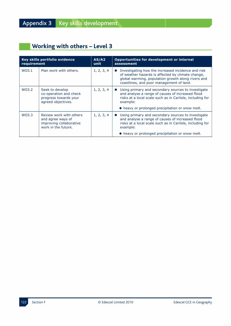
Appendix 3 Key skills development
Section F © Edexcel Limited 20�0 Edexcel GCE in Geography�22
Working with others – Level 3
Key skills portfolio evidence requirement
AS/A2 unit
Opportunities for development or internal assessment
WO3.1 Plan work with others. 1, 2, 3, 4 Investigating how the increased incidence and risk of weather hazards is affected by climate change, global warming, population growth along rivers and coastlines, and poor management of land.
WO3.2 Seek to develop co-operation and check progress towards your agreed objectives.
1, 2, 3, 4 Using primary and secondary sources to investigate and analyse a range of causes of increased flood risks at a local scale such as in Carlisle, including for example:
heavy or prolonged precipitation or snow melt.
WO3.3 Review work with others and agree ways of improving collaborative work in the future.
1, 2, 3, 4 Using primary and secondary sources to investigate and analyse a range of causes of increased flood risks at a local scale such as in Carlisle, including for example:
heavy or prolonged precipitation or snow melt.
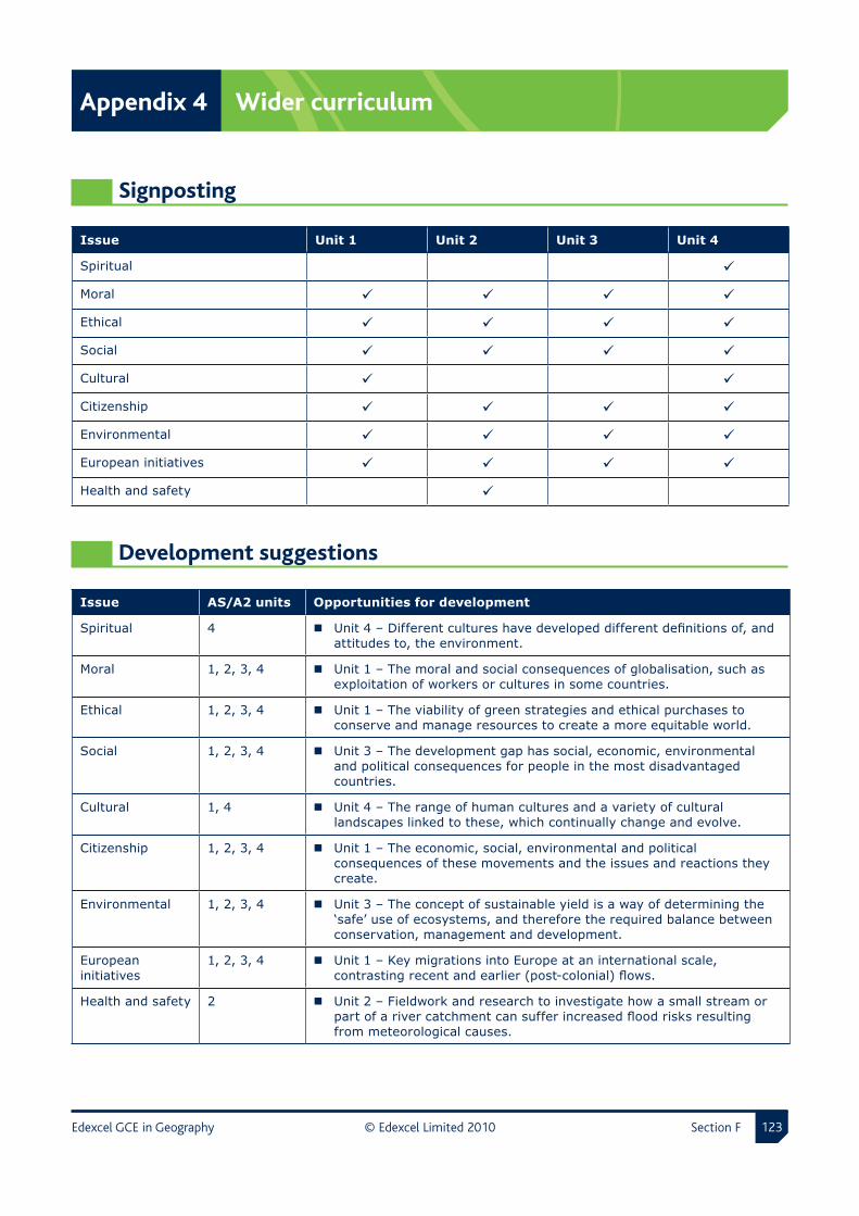
Edexcel GCE in Geography © Edexcel Limited 20�0 Section F �2�
Appendix 4 Wider curriculum
Signposting
Issue Unit 1 Unit 2 Unit 3 Unit 4
Spiritual
Moral
Ethical
Social
Cultural
Citizenship
Environmental
European initiatives
Health and safety
Development suggestions
Issue AS/A2 units Opportunities for development
Spiritual 4 Unit 4 – Different cultures have developed different definitions of, and attitudes to, the environment.
Moral 1, 2, 3, 4 Unit 1 – The moral and social consequences of globalisation, such as exploitation of workers or cultures in some countries.
Ethical 1, 2, 3, 4 Unit 1 – The viability of green strategies and ethical purchases to conserve and manage resources to create a more equitable world.
Social 1, 2, 3, 4 Unit 3 – The development gap has social, economic, environmental and political consequences for people in the most disadvantaged countries.
Cultural 1, 4 Unit 4 – The range of human cultures and a variety of cultural landscapes linked to these, which continually change and evolve.
Citizenship 1, 2, 3, 4 Unit 1 – The economic, social, environmental and political consequences of these movements and the issues and reactions they create.
Environmental 1, 2, 3, 4 Unit 3 – The concept of sustainable yield is a way of determining the ‘safe’ use of ecosystems, and therefore the required balance between conservation, management and development.
European initiatives
1, 2, 3, 4 Unit 1 – Key migrations into Europe at an international scale, contrasting recent and earlier (post-colonial) flows.
Health and safety 2 Unit 2 – Fieldwork and research to investigate how a small stream or part of a river catchment can suffer increased flood risks resulting from meteorological causes.

F Appendices
Section F © Edexcel Limited 20�0 Edexcel GCE in Geography�2�
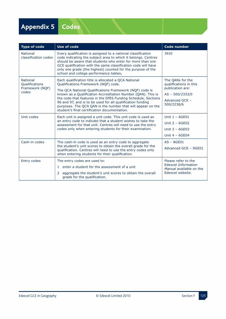
Edexcel GCE in Geography © Edexcel Limited 20�0 Section F �2�
Appendix 5 Codes
Type of code Use of code Code number
National classification codes
Every qualification is assigned to a national classification code indicating the subject area to which it belongs. Centres should be aware that students who enter for more than one GCE qualification with the same classification code will have only one grade (the highest) counted for the purpose of the school and college performance tables.
3910
National Qualifications Framework (NQF) codes
Each qualification title is allocated a QCA National Qualifications Framework (NQF) code.
The QCA National Qualifications Framework (NQF) code is known as a Qualification Accreditation Number (QAN). This is the code that features in the DfES Funding Schedule, Sections 96 and 97, and is to be used for all qualification funding purposes. The QCA QAN is the number that will appear on the student’s final certification documentation.
The QANs for the qualifications in this publication are:
AS – 500/2333/0
Advanced GCE – 500/2238/6
Unit codes Each unit is assigned a unit code. This unit code is used as an entry code to indicate that a student wishes to take the assessment for that unit. Centres will need to use the entry codes only when entering students for their examination.
Unit 1 – 6GE01
Unit 2 – 6GE02
Unit 3 – 6GE03
Unit 4 – 6GE04
Cash-in codes The cash-in code is used as an entry code to aggregate the student’s unit scores to obtain the overall grade for the qualification. Centres will need to use the entry codes only when entering students for their qualification.
AS – 8GE01
Advanced GCE – 9GE01
Entry codes The entry codes are used to:
1 enter a student for the assessment of a unit
2 aggregate the student’s unit scores to obtain the overall grade for the qualification.
Please refer to the Edexcel Information Manual available on the Edexcel website.

F Appendices
Section F © Edexcel Limited 20�0 Edexcel GCE in Geography�2�

Edexcel GCE in Geography © Edexcel Limited 20�0 Section F �2�
Appendix 6 Glossary
BRIC Brazil, Russia, India and China
CRED Centre for Research on the Epidemiology of Disasters
EU European Union
FSC Former Soviet Country
G8 Group of 8 (Canada, France, Germany, Italy, Japan, Russia, UK and USA)
GDP Gross domestic product
GIS Geographic information system
GM Genetically Modified
HDI Human Development Index
HIPC Heavily Indebted Poor Countries
ICZM Integrated Coastal Zone Management
IGO Intergovernmental Organisation
IMF International Monetary Fund
IPCC Intergovernmental Panel on Climate Change
LDC Less Developed Country
LEAF Linking the Environment and Farming
LEDC Less economically developed country
MDG Millennium Development Goals
MEA Millennium Ecosystem Assessment
NATO North Atlantic Treaty Organisation
NGO Non-governmental organisation
NIC Newly Industrialised Country
NOAA National Oceanic and Atmospheric Administration
OECD Organisation for Economic Co-operation and Development
OPEC Organization of the Petroleum Exporting Countries
RIC Recently Industrialised Country
SAPs Structural Adjustment Programs
SMP Shoreline Management Plan
SSSI Site of Special Scientific Interest
TNC Trans-National Corporation
UN United Nations
UNICEF United Nations Children’s Fund
WHO World Health Organization
WTO World Trade Organization

F Appendices
Section F © Edexcel Limited 20�0 Edexcel GCE in Geography�2�

Edexcel GCE in Geography © Edexcel Limited 20�0 Section F �2�
Appendix 7 Disability Discrimination Act
AS/A levels often require assessment of a broad range of competences. This is because they are general qualifications and, as such, prepare candidates for a wide range of occupations and higher level courses.
The revised AS/A level qualification and subject criteria were reviewed to identify whether any of the competences required by the subject presented a potential barrier to any disabled candidates. If this was the case, the situation was reviewed again to ensure that such competences were included only where essential to the subject. The findings of this process were discussed with disability groups and with disabled people.
Reasonable adjustments are made for disabled candidates in order to enable them to access the assessments. For this reason, very few candidates will have a complete barrier to any part of the assessment. For information on reasonable adjustments please see the Edexcel website (www.edexcel.com).
Candidates who are still unable to access a significant part of the assessment, even after exploring all possibilities through reasonable adjustments, may still be able to receive an award. They would be given a grade on the parts of the assessment they have taken and there would be an indication on their certificate that not all of the competencies have been addressed. This will be kept under review and may be amended in the future.
Requirements for fieldwork are sufficiently flexible for all candidates to participate.
Candidates with visual impairments may have difficulty in demonstrating skills related to analysis, interpretation and evaluation of geographical information including maps, 3-D and colour images.
3410db200510/S:/LT/PD/GCE/UA024843 GCE Geography Issue 3.indd/133/1
Edexcel, a Pearson company, is the UK’s largest awarding body, offering academic and vocational qualifications and testing to more than 25,000 schools, colleges, employers and other places of learning in the UK and in over 100 countries worldwide. Qualifications include GCSE, AS and A Level, NVQ and our BTEC suite of vocational qualifications from entry level to BTEC Higher National Diplomas, recognised by employers and higher education institutions worldwide.
We deliver 9.4 million exam scripts each year, with more than 90% of exam papers marked onscreen annually. As part of Pearson, Edexcel continues to invest in cutting-edge technology that has revolutionised the examinations and assessment system. This includes the ability to provide detailed performance data to teachers and students which helps to raise attainment.
Acknowledgements
This specification has been produced by Edexcel on the basis of consultation with teachers, examiners, consultants and other interested parties. Edexcel acknowledges its indebtedness to all those who contributed their time and expertise to the development of Advanced Subsidiary/Advanced GCE specifications.
References to third-party material made in this specification are made in good faith. Edexcel does not endorse, approve or accept responsibility for the content of materials, which may be subject to change, or any opinions expressed therein. (Material may include textbooks, journals, magazines and other publications and websites.)
Authorised by Roger Beard Prepared by Matt Gregory
Publications code UA024843
All the material in this publication is copyright © Edexcel Limited 2010
This specification is Issue 3. Key changes are sidelined. We will inform centres of any changes to this issue. The latest issue can be found on the Edexcel website: www.edexcel.com

Further �copies �of �this �publication �are �available �fromEdexcel �Publications, �Adamsway, �Mansfi �eld, �Notts, �NG18 �4FN
Telephone: �01623 �467467Fax: �01623 �450481Email: �[email protected]
Publications �code �UA024843 � �May �2010
For �more �information �on �Edexcel �and �BTEC �qualifi �cations �please �visit �our �website: �www.edexcel.com
Edexcel �Limited. �Registered �in �England �and �Wales �No. �4496750Registered �Offi �ce: �One90 �High �Holborn, �London �WC1V �7BH. �VAT �Reg �No �780 �0898 �07