Embed Size (px)
Citation preview
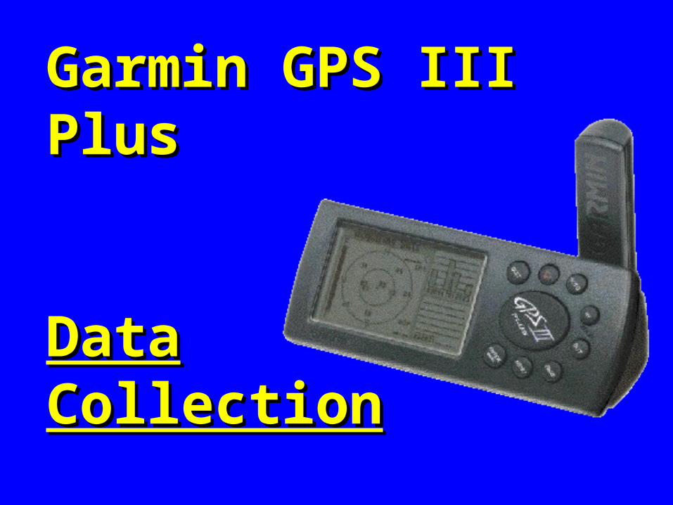
Garmin GPS III PlusGarmin GPS III Plus
DataDataCollectionCollection
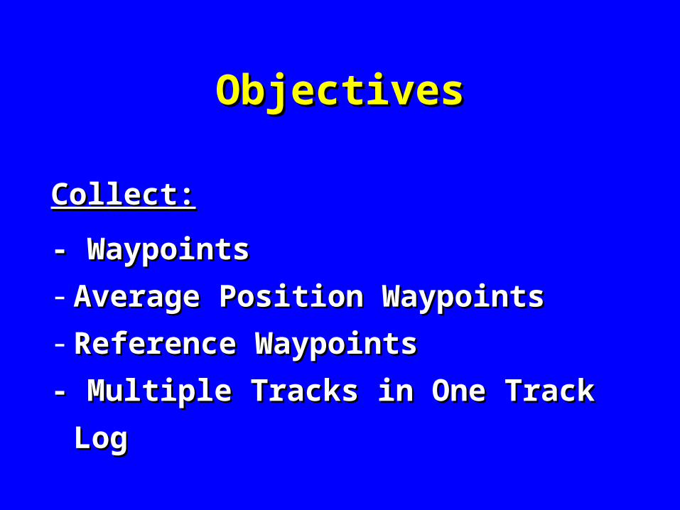
ObjectivesObjectives
Collect:Collect:
- Waypoints- Waypoints
- Average Position WaypointsAverage Position Waypoints
- Reference WaypointsReference Waypoints
- Multiple Tracks in One Track Log- Multiple Tracks in One Track Log
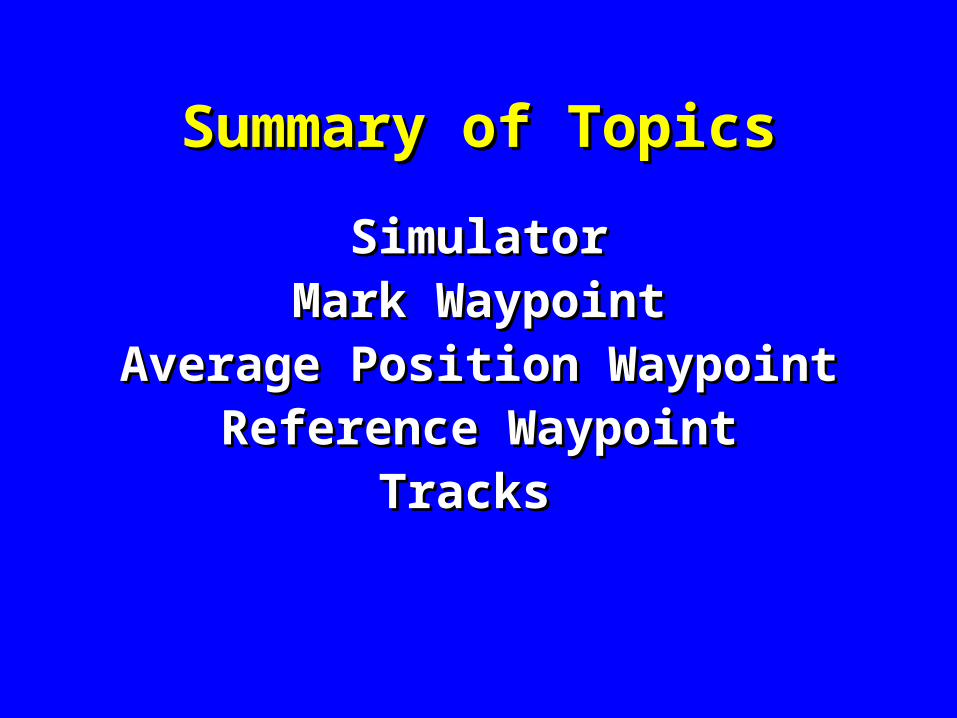
Summary of TopicsSummary of Topics
SimulatorSimulatorMark WaypointMark Waypoint
Average Position WaypointAverage Position WaypointReference WaypointReference Waypoint
Tracks Tracks
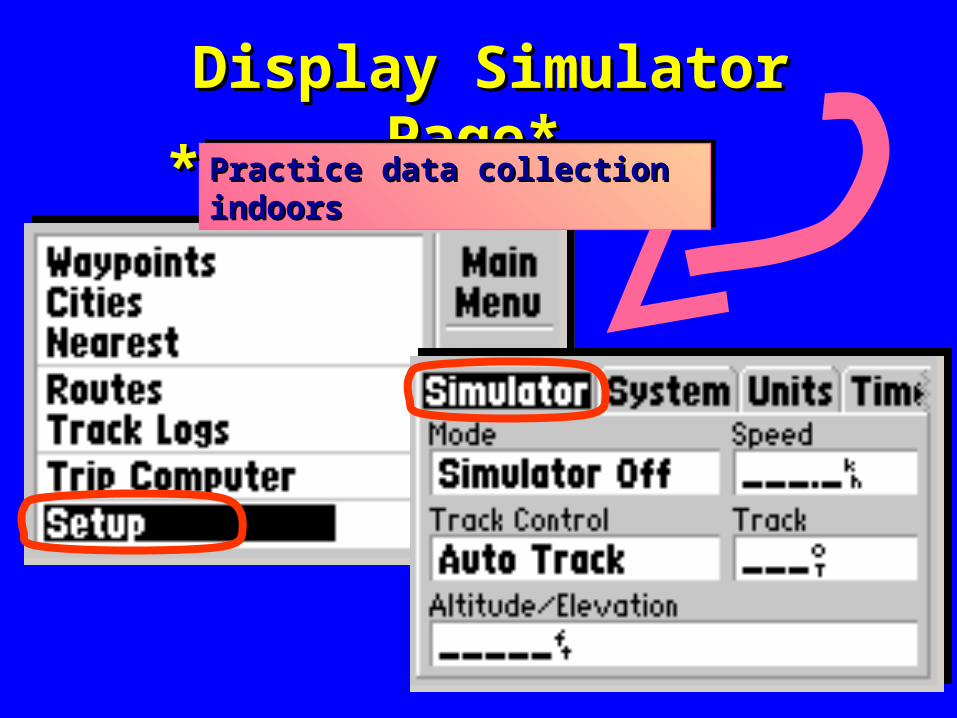
Display Simulator Page* Display Simulator Page* Practice data collection indoorsPractice data collection indoorsPractice data collection indoorsPractice data collection indoors**
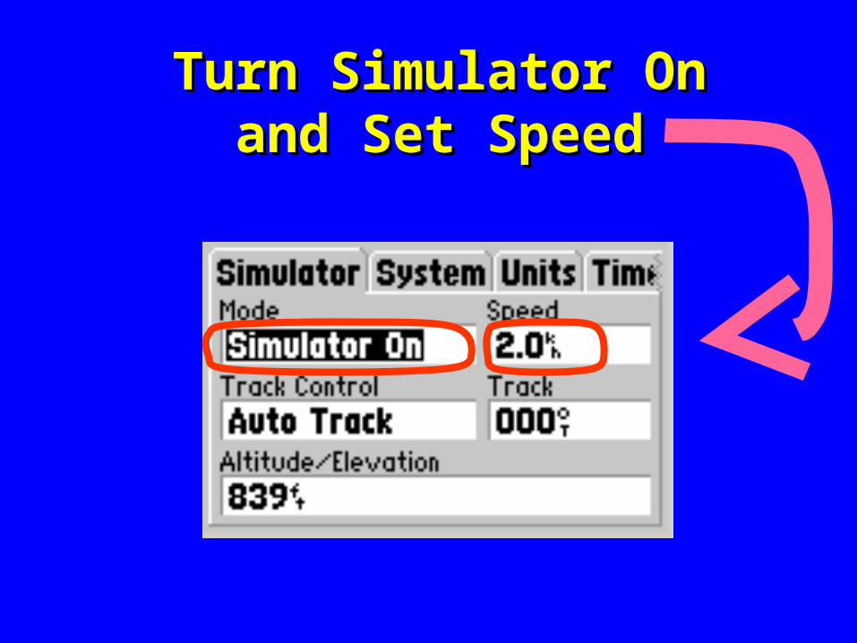
Turn Simulator OnTurn Simulator Onand Set Speedand Set Speed
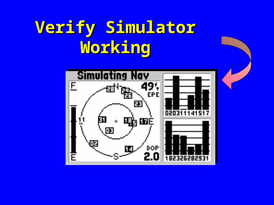
Verify Simulator WorkingVerify Simulator Working
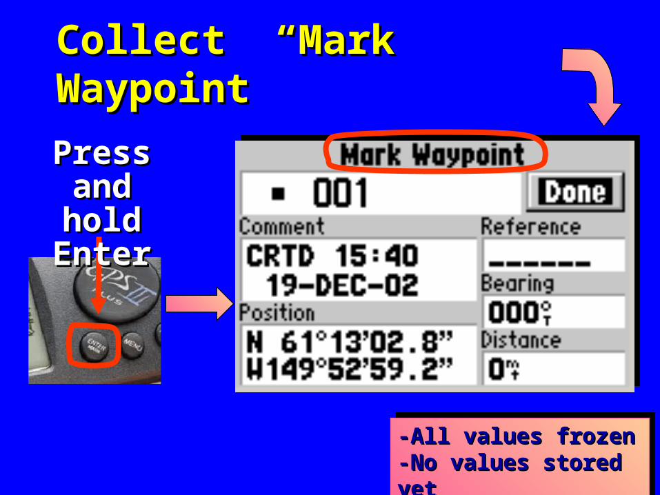
Collect “Mark” Waypoint Collect “Mark” Waypoint
-All values frozen-All values frozen-No values stored yet -No values stored yet -All values frozen-All values frozen-No values stored yet -No values stored yet
Press Press and hold and hold
EnterEnter
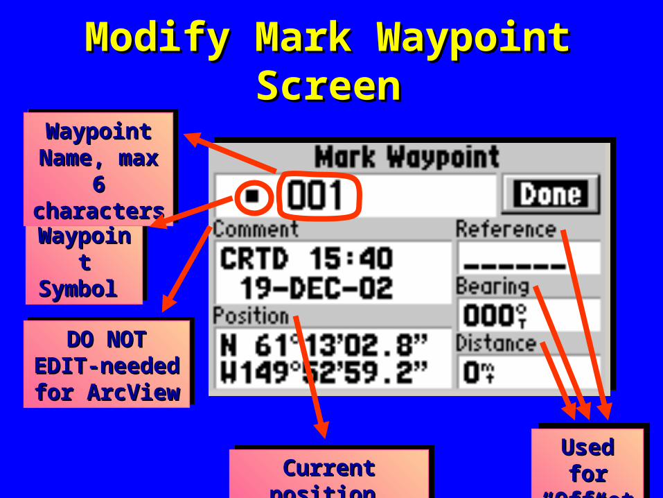
Modify Mark Waypoint ScreenModify Mark Waypoint Screen
Used for Used for “Offset”“Offset”
Used for Used for “Offset”“Offset”Current position Current position Current position Current position
DO NOT EDIT-DO NOT EDIT-needed for needed for ArcView ArcView
DO NOT EDIT-DO NOT EDIT-needed for needed for ArcView ArcView
Waypoint Waypoint Symbol Symbol
Waypoint Waypoint Symbol Symbol
Waypoint Waypoint Name, max 6 Name, max 6 characters characters
Waypoint Waypoint Name, max 6 Name, max 6 characters characters
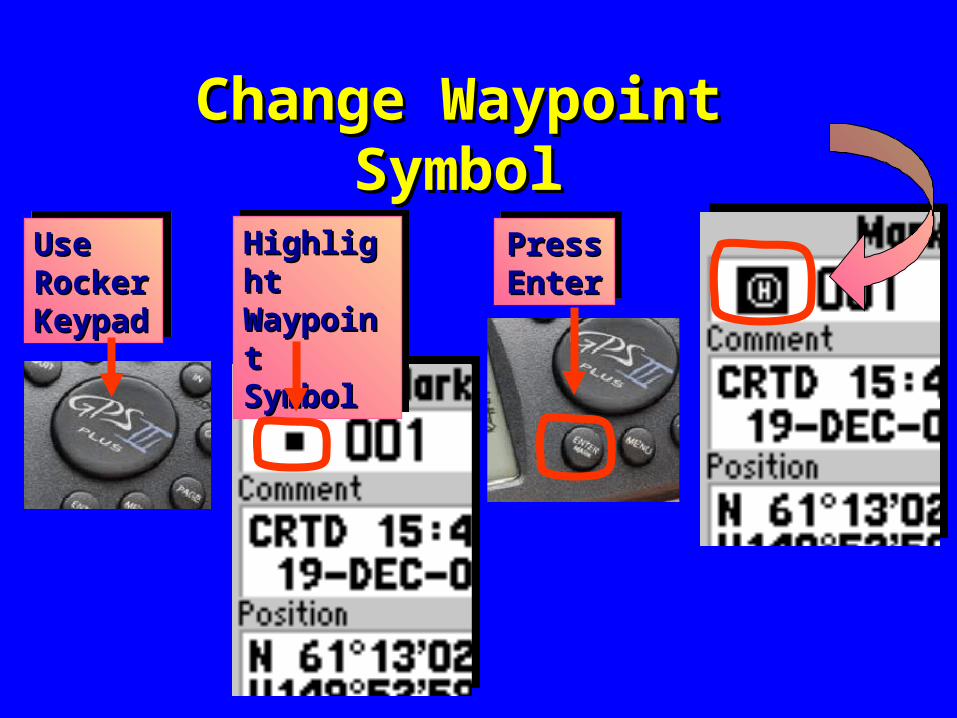
Change Waypoint SymbolChange Waypoint Symbol
Use Use Rocker Rocker Keypad Keypad
Use Use Rocker Rocker Keypad Keypad
Highlight Highlight Waypoint Waypoint Symbol Symbol
Highlight Highlight Waypoint Waypoint Symbol Symbol
Press Press Enter Enter Press Press Enter Enter
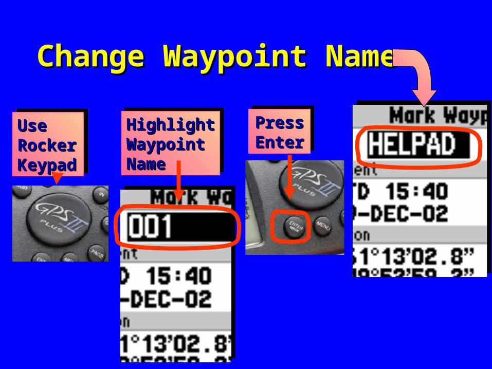
Change Waypoint NameChange Waypoint Name
Highlight Highlight Waypoint Waypoint Name Name
Highlight Highlight Waypoint Waypoint Name Name
Use Use Rocker Rocker Keypad Keypad
Use Use Rocker Rocker Keypad Keypad
Press Press Enter Enter Press Press Enter Enter
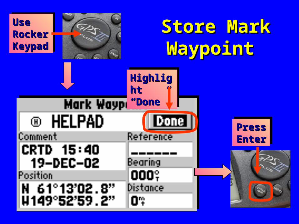
Store Mark Store Mark Waypoint Waypoint
Highlight Highlight “Done” “Done” Highlight Highlight “Done” “Done”
Use Use Rocker Rocker Keypad Keypad
Use Use Rocker Rocker Keypad Keypad
Press Press Enter Enter Press Press Enter Enter
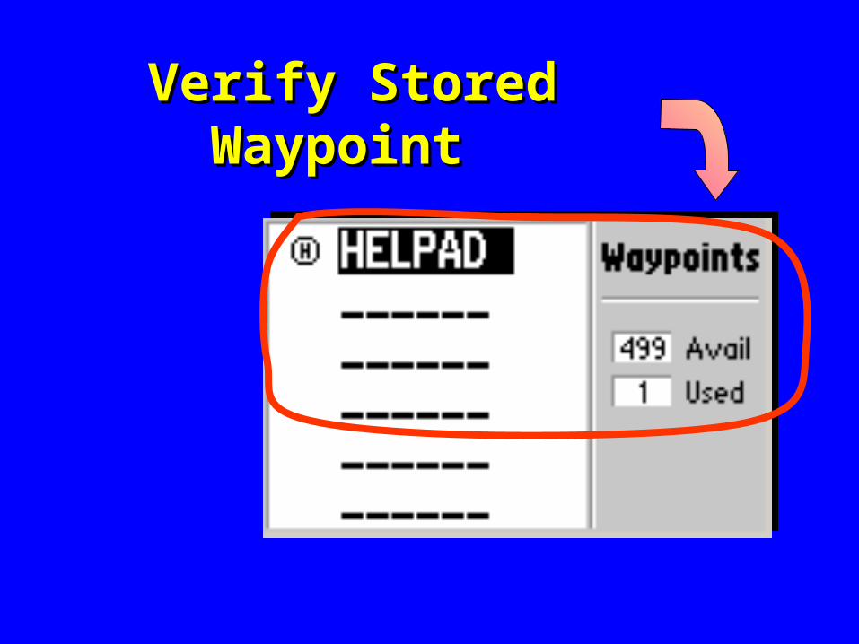
Verify Stored Waypoint Verify Stored Waypoint
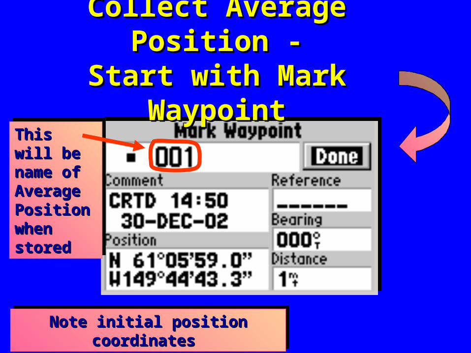
Collect Average Position -Collect Average Position -Start with Mark WaypointStart with Mark Waypoint
This will This will be name of be name of Average Average Position Position when when stored stored
This will This will be name of be name of Average Average Position Position when when stored stored
Note initial position coordinates Note initial position coordinates Note initial position coordinates Note initial position coordinates
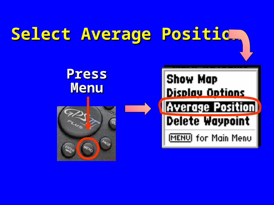
Select Average PositionSelect Average Position
Press Press MenuMenu
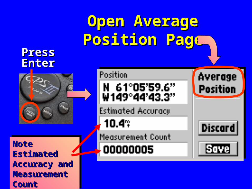
Open Average Open Average Position PagePosition Page
PressPressEnterEnter
Note Estimated Note Estimated Accuracy and Accuracy and Measurement Measurement CountCount
Note Estimated Note Estimated Accuracy and Accuracy and Measurement Measurement CountCount
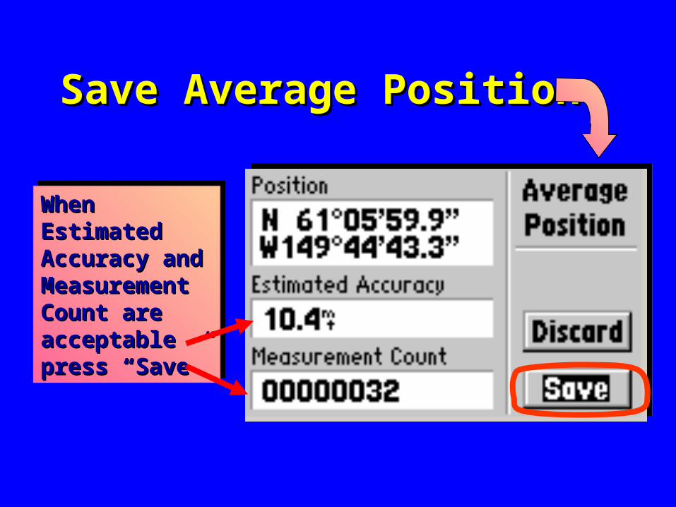
Save Average PositionSave Average Position
When When Estimated Estimated Accuracy and Accuracy and Measurement Measurement Count are Count are acceptable acceptable press “Save”press “Save”
When When Estimated Estimated Accuracy and Accuracy and Measurement Measurement Count are Count are acceptable acceptable press “Save”press “Save”
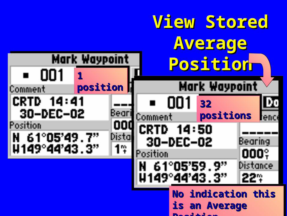
View Stored View Stored Average Average PositionPosition
1 position 1 position 1 position 1 position
32 positions 32 positions 32 positions 32 positions
No indication this is an No indication this is an Average PositionAverage PositionNo indication this is an No indication this is an Average PositionAverage Position
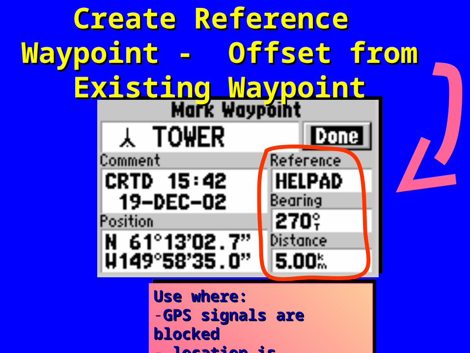
Create Reference Waypoint - Create Reference Waypoint - Offset from Existing WaypointOffset from Existing Waypoint
Use where:Use where:-GPS signals are blocked GPS signals are blocked - location is inaccessible - location is inaccessible
Use where:Use where:-GPS signals are blocked GPS signals are blocked - location is inaccessible - location is inaccessible
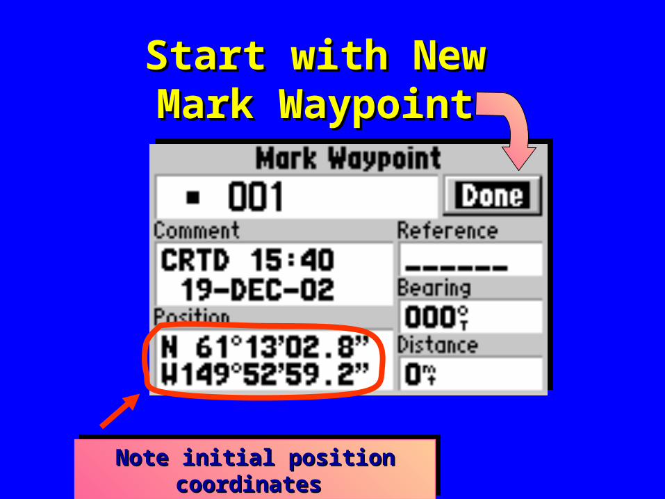
Start with NewStart with NewMark WaypointMark Waypoint
Note initial position coordinates Note initial position coordinates Note initial position coordinates Note initial position coordinates
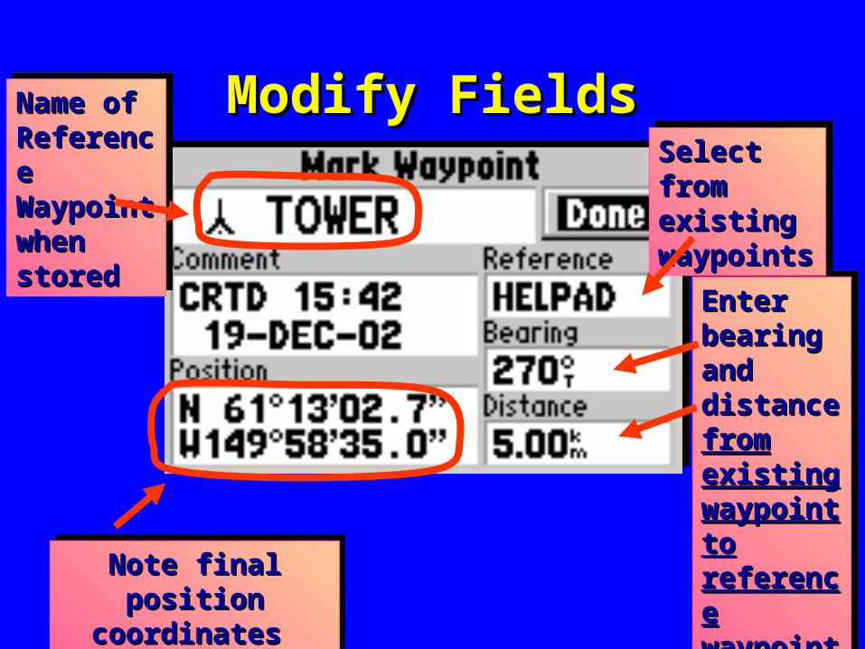
Modify FieldsModify FieldsName of Name of Reference Reference Waypoint Waypoint when when stored stored
Name of Name of Reference Reference Waypoint Waypoint when when stored stored
Note final position Note final position coordinates coordinates
Note final position Note final position coordinates coordinates
Enter Enter bearing bearing and and distance distance from from existing existing waypoint waypoint to to reference reference waypointwaypoint
Enter Enter bearing bearing and and distance distance from from existing existing waypoint waypoint to to reference reference waypointwaypoint
Select from Select from existing existing waypointswaypoints
Select from Select from existing existing waypointswaypoints
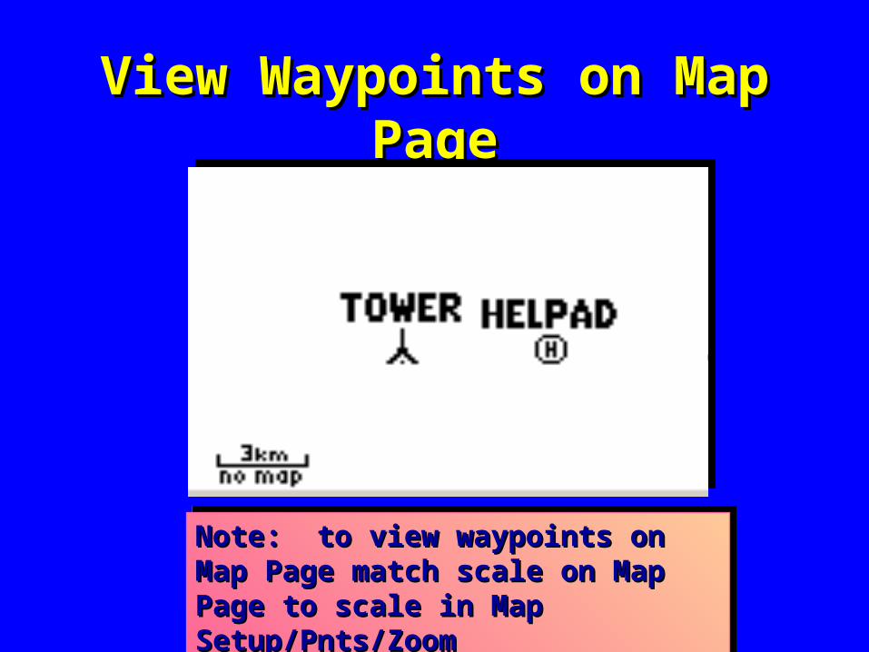
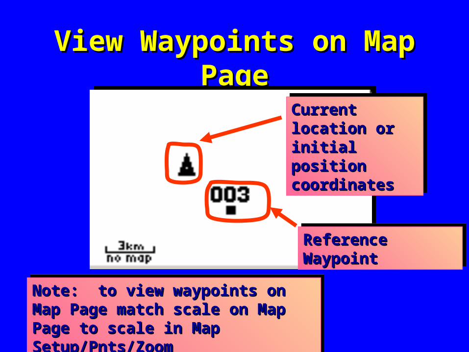
View Waypoints on Map PageView Waypoints on Map Page
Note: to view waypoints on Map Page Note: to view waypoints on Map Page match scale on Map Page to scale in match scale on Map Page to scale in Map Setup/Pnts/ZoomMap Setup/Pnts/Zoom
Note: to view waypoints on Map Page Note: to view waypoints on Map Page match scale on Map Page to scale in match scale on Map Page to scale in Map Setup/Pnts/ZoomMap Setup/Pnts/Zoom
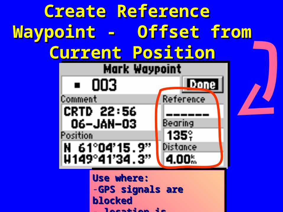
Create Reference Waypoint - Create Reference Waypoint - Offset from Current PositionOffset from Current Position
Use where:Use where:-GPS signals are blocked GPS signals are blocked - location is inaccessible - location is inaccessible
Use where:Use where:-GPS signals are blocked GPS signals are blocked - location is inaccessible - location is inaccessible
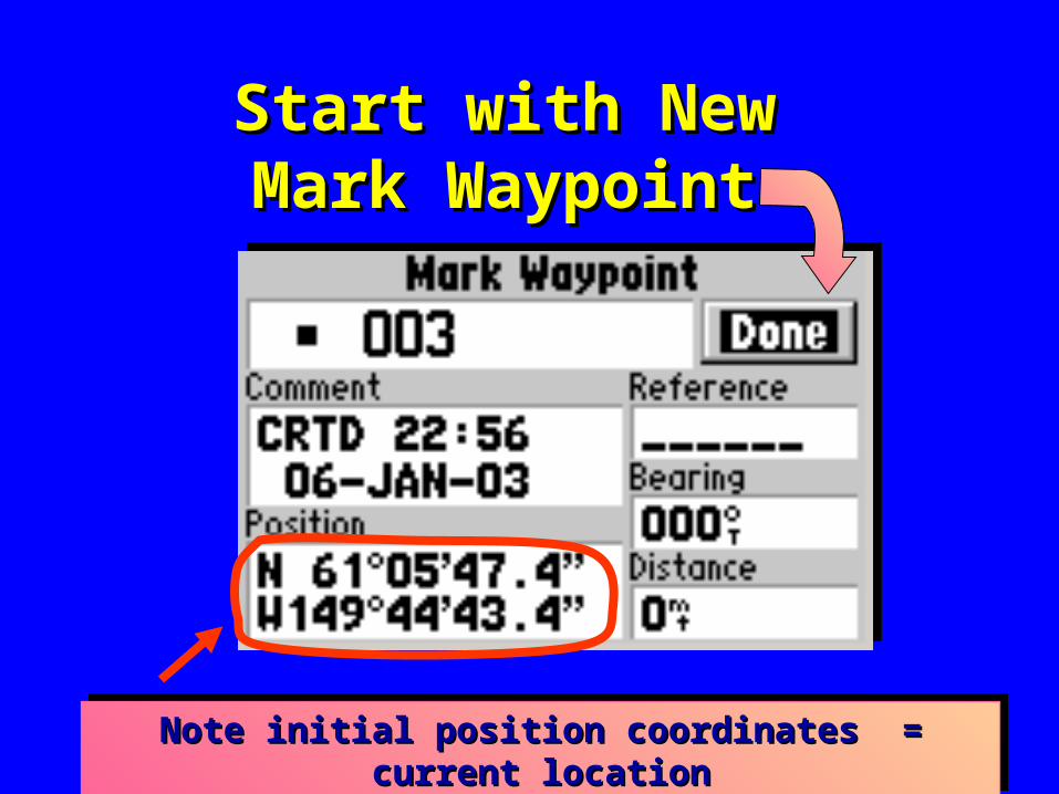
Start with NewStart with NewMark WaypointMark Waypoint
Note initial position coordinates = current locationNote initial position coordinates = current locationNote initial position coordinates = current locationNote initial position coordinates = current location
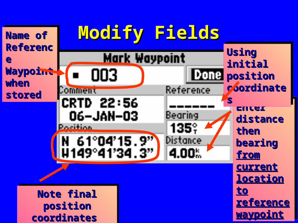
Modify FieldsModify FieldsName of Name of Reference Reference Waypoint Waypoint when when stored stored
Name of Name of Reference Reference Waypoint Waypoint when when stored stored
Note final position Note final position coordinates coordinates
Note final position Note final position coordinates coordinates
Enter Enter distance distance then then bearing bearing from from current current location to location to reference reference waypointwaypoint
Enter Enter distance distance then then bearing bearing from from current current location to location to reference reference waypointwaypoint
Using initial Using initial position position coordinatescoordinates
Using initial Using initial position position coordinatescoordinates
View Waypoints on Map PageView Waypoints on Map Page
Note: to view waypoints on Map Page Note: to view waypoints on Map Page match scale on Map Page to scale in match scale on Map Page to scale in Map Setup/Pnts/ZoomMap Setup/Pnts/Zoom
Note: to view waypoints on Map Page Note: to view waypoints on Map Page match scale on Map Page to scale in match scale on Map Page to scale in Map Setup/Pnts/ZoomMap Setup/Pnts/Zoom
Reference WaypointReference WaypointReference WaypointReference Waypoint
Current location Current location or initial position or initial position coordinatescoordinates
Current location Current location or initial position or initial position coordinatescoordinates
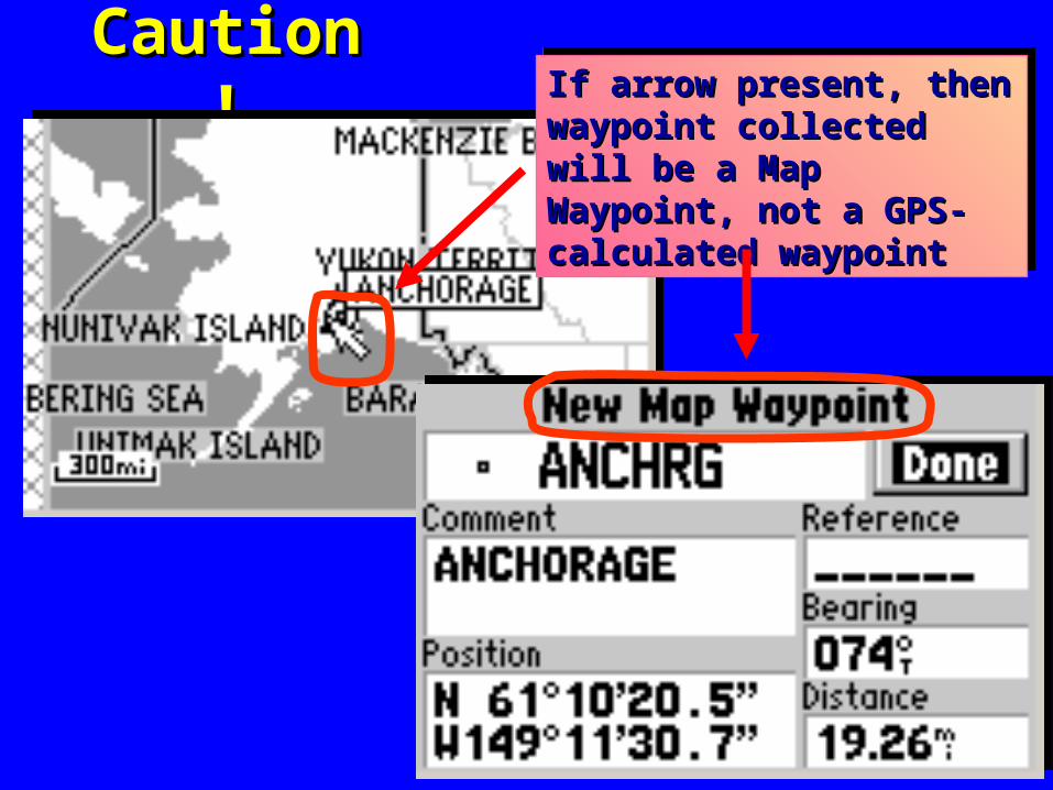
Caution!Caution! If arrow present, then If arrow present, then waypoint collected will be a waypoint collected will be a Map Waypoint, not a GPS- Map Waypoint, not a GPS- calculated waypointcalculated waypoint
If arrow present, then If arrow present, then waypoint collected will be a waypoint collected will be a Map Waypoint, not a GPS- Map Waypoint, not a GPS- calculated waypointcalculated waypoint
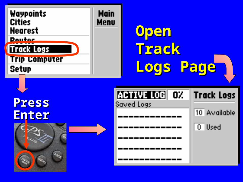
Open Track Open Track Logs PageLogs Page
Press Press EnterEnter
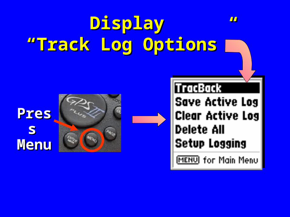
Display Display “Track Log Options” “Track Log Options”
PressPressMenuMenu
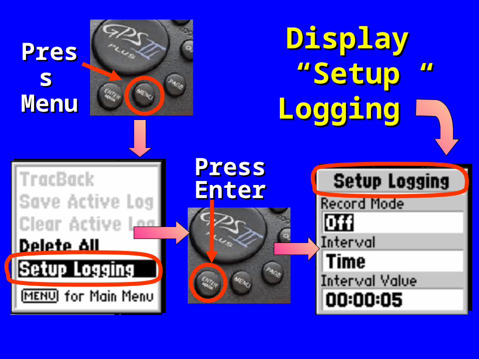
Display Display “Setup “Setup
Logging”Logging”
PressPressMenuMenu
PressPressEnterEnter
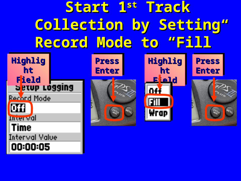
Start 1Start 1stst Track Collection by Track Collection by Setting Record Mode to “Fill”Setting Record Mode to “Fill”
Highlight Highlight FieldField
Highlight Highlight FieldField
Highlight Highlight FieldField
Highlight Highlight FieldField
Press Press Enter Enter Press Press Enter Enter
Press Press Enter Enter Press Press Enter Enter
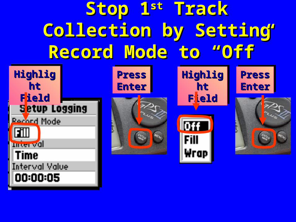
Stop 1Stop 1stst Track Collection by Track Collection by Setting Record Mode to “Off”Setting Record Mode to “Off”
Highlight Highlight FieldField
Highlight Highlight FieldField
Highlight Highlight FieldField
Highlight Highlight FieldField
Press Press Enter Enter Press Press Enter Enter
Press Press Enter Enter Press Press Enter Enter
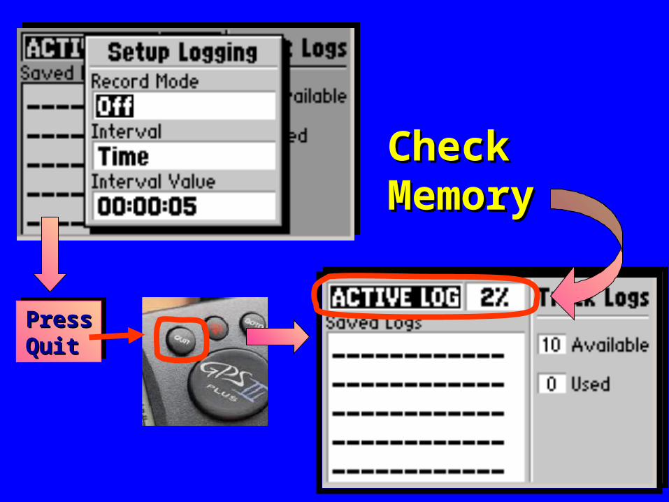
Check Check MemoryMemory
Press Press Quit Quit
Press Press Quit Quit
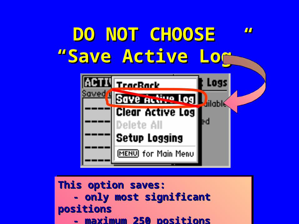
DO NOT CHOOSE DO NOT CHOOSE “Save Active Log”“Save Active Log”
This option saves:This option saves:- only most significant positions- only most significant positions
- maximum 250 positions- maximum 250 positions
This option saves:This option saves:- only most significant positions- only most significant positions
- maximum 250 positions- maximum 250 positions
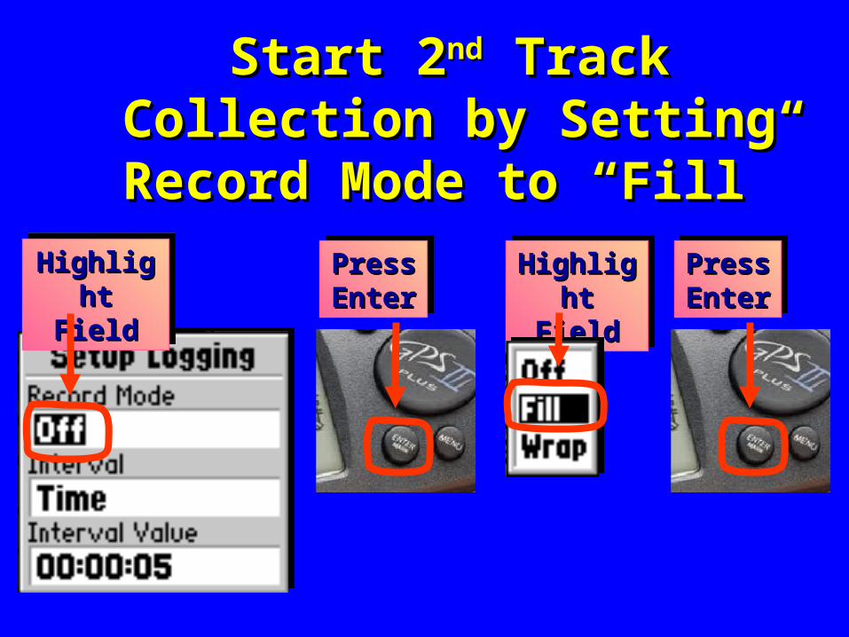
Start 2Start 2ndnd Track Collection by Track Collection by Setting Record Mode to “Fill”Setting Record Mode to “Fill”
Highlight Highlight FieldField
Highlight Highlight FieldField
Highlight Highlight FieldField
Highlight Highlight FieldField
Press Press Enter Enter Press Press Enter Enter
Press Press Enter Enter Press Press Enter Enter
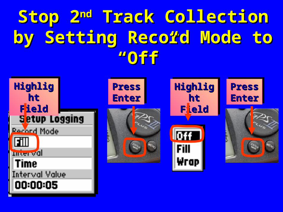
Stop 2Stop 2ndnd Track Collection by Track Collection by Setting Record Mode to “Off”Setting Record Mode to “Off”
Highlight Highlight FieldField
Highlight Highlight FieldField
Highlight Highlight FieldField
Highlight Highlight FieldField
Press Press Enter Enter Press Press Enter Enter
Press Press Enter Enter Press Press Enter Enter
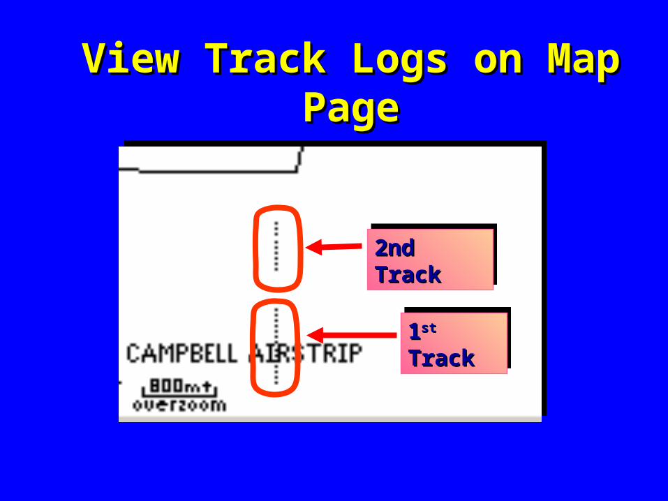
View Track Logs on Map PageView Track Logs on Map Page
11stst Track Track 11stst Track Track
2nd Track 2nd Track 2nd Track 2nd Track
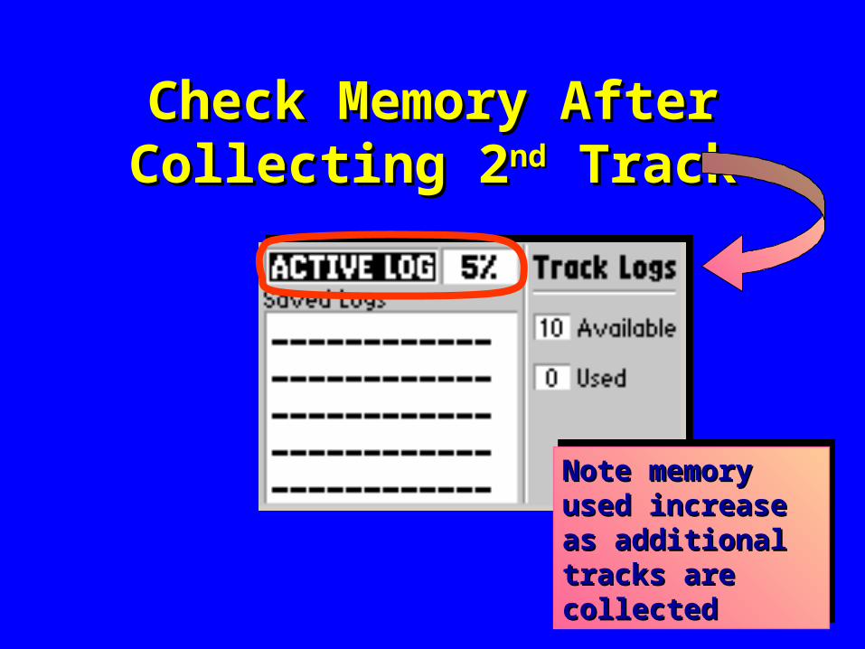
Check Memory After Check Memory After Collecting 2Collecting 2ndnd Track Track
Note memory Note memory used increase as used increase as additional tracks additional tracks are collected are collected
Note memory Note memory used increase as used increase as additional tracks additional tracks are collected are collected

Summary of TopicsSummary of Topics
SimulatorSimulatorMark WaypointMark Waypoint
Average Position WaypointAverage Position WaypointReference WaypointReference Waypoint
Tracks Tracks

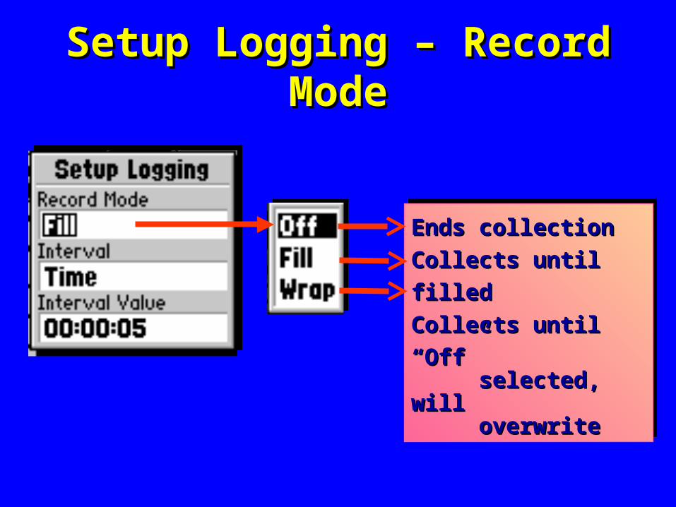
Setup Logging – Record ModeSetup Logging – Record Mode
Ends collectionEnds collection
Collects until filledCollects until filled
Collects until “Off”Collects until “Off” selected, willselected, will overwrite overwrite
Ends collectionEnds collection
Collects until filledCollects until filled
Collects until “Off”Collects until “Off” selected, willselected, will overwrite overwrite
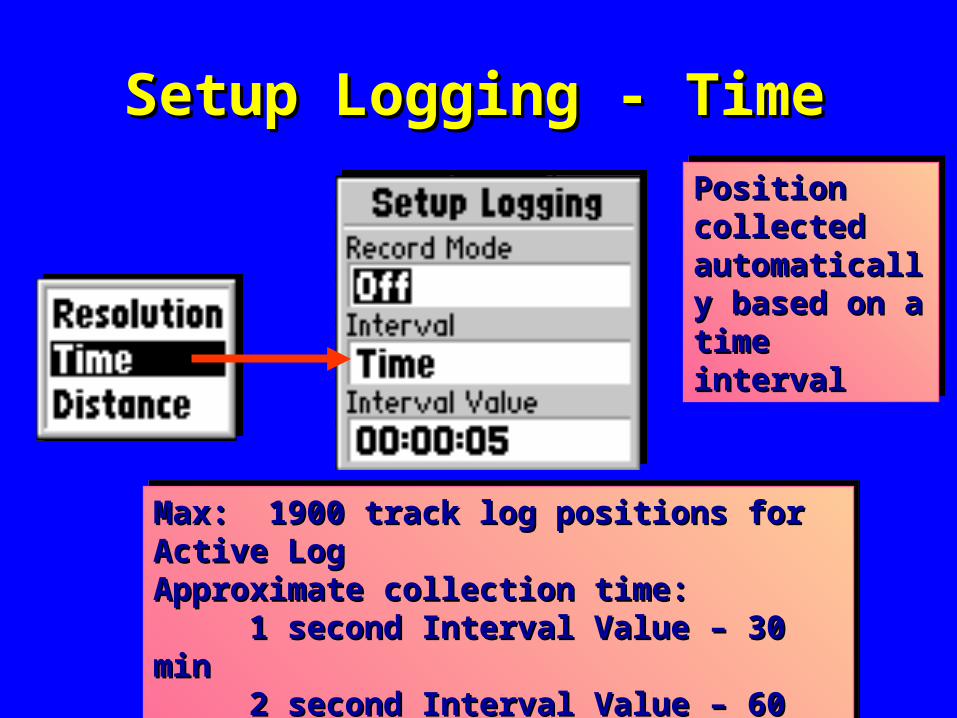
Setup Logging - TimeSetup Logging - Time
Max: 1900 track log positions for Active LogMax: 1900 track log positions for Active LogApproximate collection time:Approximate collection time:
1 second Interval Value – 30 min1 second Interval Value – 30 min2 second Interval Value – 60 min 2 second Interval Value – 60 min 5 second Interval Value – 2.5 hours5 second Interval Value – 2.5 hours
Position Position collected collected automatically automatically based on a based on a time intervaltime interval
Position Position collected collected automatically automatically based on a based on a time intervaltime interval
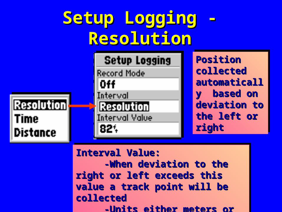
Setup Logging - ResolutionSetup Logging - Resolution
Position Position collected collected automatically automatically based on based on deviation to the deviation to the left or right left or right
Position Position collected collected automatically automatically based on based on deviation to the deviation to the left or right left or right
Interval Value: Interval Value: -When deviation to the right or -When deviation to the right or
left exceeds this value a track point left exceeds this value a track point will be collected will be collected
-Units either meters or feet -Units either meters or feet
Interval Value: Interval Value: -When deviation to the right or -When deviation to the right or
left exceeds this value a track point left exceeds this value a track point will be collected will be collected
-Units either meters or feet -Units either meters or feet
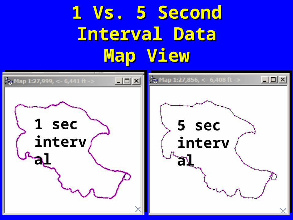
1 Vs. 5 Second Interval Data1 Vs. 5 Second Interval DataMap ViewMap View
1 secinterval
5 secinterval
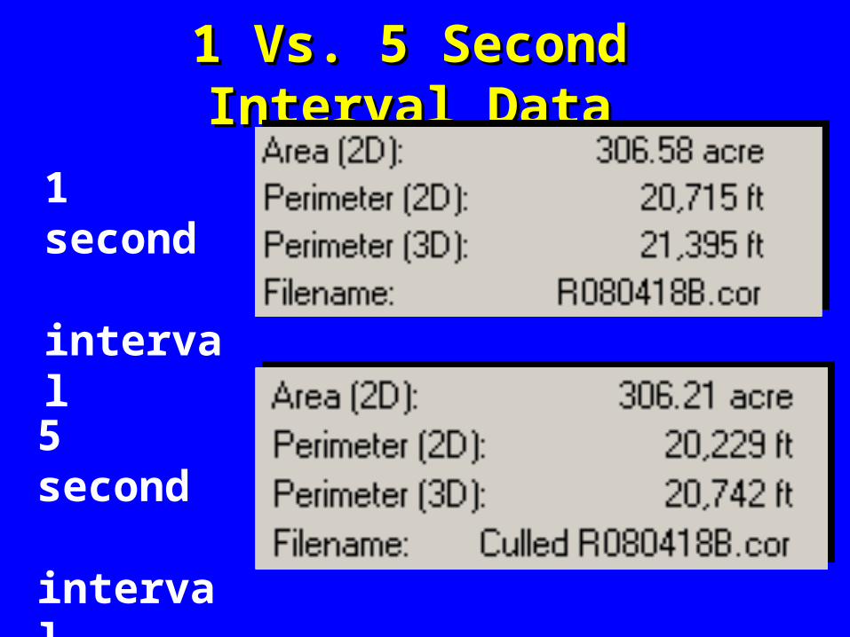
1 Vs. 5 Second Interval Data1 Vs. 5 Second Interval Data
1 second interval
5 second interval