Embed Size (px)
Citation preview

Former Vauxhall Garage
Bury Road, Thetford, Norfolk
March 2004
Archaeological Watching Brief Report
Ref: 55490.01
Wes
sex
Arc
ha
eolo
gy
FORMER VAUXHALL GARAGE BURY ROAD, THETFORD
NORFOLK
ARCHAEOLOGICAL WATCHING BRIEF REPORT
Prepared for:
CgMs Consulting
by
Wessex Archaeology Portway House Old Sarum Park
Salisbury Wiltshire SP4 6EB
REF 55490
March 2004
@ Copyright The Trust for Wessex Archaeology Limited, 2004 The Trust for Wessex Archaeology Limited is a Registered Charity No. 287786
CONTENTS
1 INTRODUCTION........................................................................................... 1 1.1 Project Background ............................................................................... 1 1.2 The Site................................................................................................... 1 1.3 Archaeological Background................................................................... 2
2 WATCHING BRIEF OBJECTIVES ............................................................. 2 3 METHODOLOGY.......................................................................................... 3 3.1 Health And Safety.................................................................................. 3
3.2 Fieldwork................................................................................................ 3 4 RESULTS ........................................................................................................ 4
4.1 Overview................................................................................................. 4 4.2 Test Pit 1 ................................................................................................. 4 4.3 Test Pit 2 ................................................................................................. 4 4.4 Test Pit 3 ................................................................................................. 5 4.5 Test Pit 4 ................................................................................................. 5 4.6 Test Pit 5 ................................................................................................. 5 4.7 Test Pit 6 ................................................................................................. 5 4.8 Test Pit 7 ................................................................................................. 5 4.9 Test Pit 8 ................................................................................................. 5 4.10 Test Pit 9 ................................................................................................. 6 4.11 Test Pit 10 ............................................................................................... 6
5 FINDS .............................................................................................................. 6 5.1 Introduction............................................................................................ 6 5.2 Pottery .................................................................................................... 6 5.3 Animal Bone ........................................................................................... 7 5.4 Other Finds............................................................................................. 7
6 CONCLUSION................................................................................................ 7 7 THE ARCHIVE .............................................................................................. 8 REFERENCES......................................................................................................... 8
APPENDIX 1: TRENCH SUMMARIES APPENDIX 2: TABLE OF FINDS BY CONTEXT
FIGURES 1 Site location map 2 Test pit location plan 3 Test pit sections
i
Summary
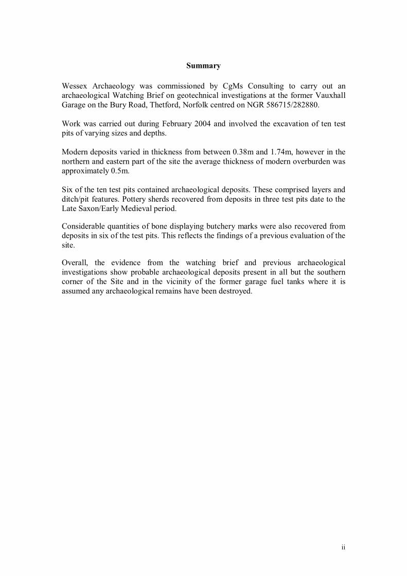
Wessex Archaeology was commissioned by CgMs Consulting to carry out an archaeological Watching Brief on geotechnical investigations at the former Vauxhall Garage on the Bury Road, Thetford, Norfolk centred on NGR 586715/282880.
Work was carried out during February 2004 and involved the excavation of ten test pits of varying sizes and depths.
Modern deposits varied in thickness from between 0.38m and 1.74m, however in the northern and eastern part of the site the average thickness of modern overburden was approximately 0.5m.
Six of the ten test pits contained archaeological deposits. These comprised layers and ditch/pit features. Pottery sherds recovered from deposits in three test pits date to the Late Saxon/Early Medieval period.
Considerable quantities of bone displaying butchery marks were also recovered from deposits in six of the test pits. This reflects the findings of a previous evaluation of the site.
Overall, the evidence from the watching brief and previous archaeological investigations show probable archaeological deposits present in all but the southern corner of the Site and in the vicinity of the former garage fuel tanks where it is assumed any archaeological remains have been destroyed.
ii

Acknowledgements
Wessex Archaeology would like to thank Rob Bourn of CgMs Consulting for his help and assistance during the course of the project.
The fieldwork was undertaken by Hugo Pinto and the report was prepared by Robert Wardill with contributions from Lorraine Mepham and Stephanie Knight (finds) and Mark Roughly (illustrations). The project was managed for Wessex Archaeology by Robert Wardill.
iii
FORMER VAUXHALL GARAGE BURY ROAD, THETFORD
NORFOLK
ARCHAEOLOGICAL WATCHING BRIEF REPORT
1 INTRODUCTION
1.1 Project Background
1.1.1 Wessex Archaeology was commissioned by CgMs Consulting to carry out an Archaeological Watching Brief on the excavation of ten geotechnical test pits at the former site of the Vauxhall Garage on the Bury Road, Thetford (the Site) centred on NGR 586715/282880. This report details the results of fieldwork undertaken on the 2nd, 3rd and 24th February 2004.
1.1.2 The Site is the proposed location for sheltered accommodation for the elderly. The geotechnical test pits were excavated to provide information to assist with design of the development.
1.1.3 The archaeological works were carried out in accordance with a Project Specification prepared by CgMs Consulting (2003) and approved by the Local Planning Authorities Archaeological Advisor, Norfolk Landscape Archaeology.
1.1.4 All works were carried out in accordance with the Institute of Field Archaeologists’ Standard and Guidance for Archaeological Field Evaluations (1994 as amended).
1.2 The Site
1.2.1 The Site is located to the south-east of the town centre, south of the Little Ouse River, at the corner of Newtown and St Mary’s Road. It comprises approximately 0.2 ha of level ground at a height of c.13m above Ordnance Datum (aOD).
1.2.2 The Site has been cleared of former garage buildings but four 18,000 litre fuel tanks are buried at the eastern end of the St Mary’s Road frontage.
1.2.3 Natural geological deposits within the trenches were found to comprise of sand and gravel.
1

1.3 Archaeological Background
1.3.1 The town of Thetford originated during the Saxon Period and appears to have quickly grown into one of the largest and most important towns in England. It was located primarily to the south of the Little Ouse with an annexed area to the north of the river (CgMs Consulting 2003).
1.3.2 By the Medieval period the town was in decline with its focus shifting to the north of the Little Ouse (CgMs Consulting 2003).
1.3.3 The site has been the subject of a previous evaluation (Archaeological Project Services 2001) and a desk-based assessment (CgMs Consulting 2003) both of which demonstrate that there is high potential for well preserved Late Saxon remains to be found at the Site.
1.3.4 The evaluation was carried out in 2001 and comprised the excavation of two 3m x 3m trenches (Figure 2). Trench 1 revealed a large feature which contained a large quantity of butchered animal bone, 10th century pottery and a coin dated between 890-905AD. Trench 2 revealed a linear feature containing 11th century pottery. In both trenches the deposits were found at a shallow depth (trench 1 c.0.25m below ground level).
1.3.5 The results of the evaluation suggested that the Site was clearly part of the Late Saxon town and contained reasonably well preserved 10th – 11th century deposits. It was possible that the Site was on the periphery of settlement to the west. Although there were indications of occupation nearby, the findings did not suggest that occupation occurred within the Site itself (CgMs Consulting 2003).
2 WATCHING BRIEF OBJECTIVES
2.1.1 The aim of the project was to determine, as far as reasonably possible, the presence/absence, extent, date, character, condition and depth of any surviving archaeological remains located within the proposed development area.
2
3 METHODOLOGY
3.1 Health and Safety
3.1.1 All work was carried out in accordance with the Health and Safety at Work Act (1974) and the Management of Health and Safety regulations (1992) and all other relevant Health and Safety legislation and regulations and codes of practice in force at the time.
3.1.2 A risk assessment was prepared by Wessex Archaeology before the commencement of fieldwork.
3.2 Fieldwork
3.2.1 All fieldwork was carried out in accordance with the Institute of Field Archaeologists’ Standard and Guidance for Archaeological Field Evaluations (as amended 1999).
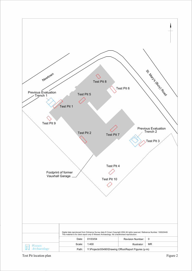
3.2.2 A total of ten test pits 1.10m wide and ranging from 1.9m to 4.7m in length and 2m to 2.65m in depth were excavated within the Site (Figure 2).
3.2.3 Removal of modern overburden and soils down to the depth required for construction was carried out by machine under the supervision of a Wessex Archaeology archaeologist.
3.2.4 Where archaeological deposits were exposed investigations are carried out by hand before machining was recommenced.
3.2.5 The excavations were not entered once they exceeded a safe depth of 1.2m.
3.2.6 Representative sections of each pit were drawn at a scale of 1:20 and described using Wessex Archaeology’s pro forma recording system. A photographic record of the works was maintained.
3.2.7 Recovered artefacts were washed and marked with site code and context number before suitable material (primarily ceramics and non-ferrous metalwork) was scanned to assess the date range of the assemblage.
3
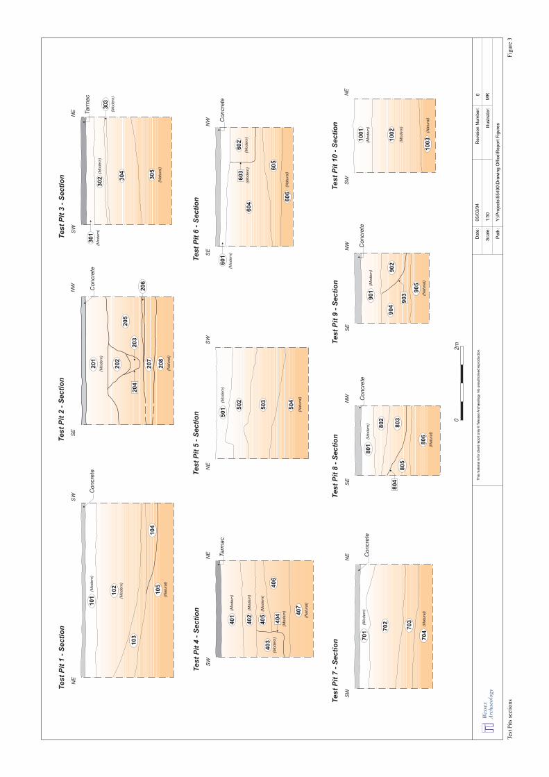
4 RESULTS (See Appendix 1 for test pit summaries and Figure 3 for section illustrations).
4.1 Overview
4.1.1 The geotechnical investigations revealed modern surfaces (concrete and tarmac) and make up levels across the entire site. Modern deposits varied in thickness from between 0.38m and 1.74m.
4.1.2 However, in the northern and eastern part of the site (test pits 3,5,6,7 and 8) the average thickness of modern overburden was approximately 0.5m. The western and southern parts of the site exhibited greater depths of make up (test pits 1, 2 and 9) with an average thickness of 0.7 – 1.0m. The very southern corner (test pit 10) had significantly greater depths at 1.74m with modern truncation down to the surface of the natural geology.
4.1.3 With the exception of test pit 10 there was an average depth of 1.0m of deposits overlying the natural. These deposits mainly comprised layers which were present in all test pits, except test pit 10, and three pit/ditch features located in test pits 2, 8 and 9. Layers and features identified as archaeological (i.e. containing quantities of animal bone and/or pottery) were found in test pits 1, 2, 5, 7, 8 and 9. Layer deposits found in test pits 3, 4, 6 produced no identifiable material and so their date of origin is uncertain.
4.1.4 The following sections provide a brief summary of the findings for each test pit with details given in Appendix 1.
4.2 Test Pit 1
4.2.1 Modern concrete and overburden was removed down to a depth of 1.60m at the south-west end of the test pit. Three layer deposits were found beneath this. Only the lowest (104), located at a depth of 1.74m, produced finds including animal bone, mussel shells and Late Saxon/Early Medieval pottery. Natural geology was encountered at a depth of 2.06m.
4.3 Test Pit 2
4.3.1 Approximately 0.65m of concrete and overburden was removed to reveal archaeological deposits consisting of the upper fill (202) of a ditch 1.2m wide at a depth of 0.70m from the ground surface. The fill contained pieces of animal bone. A further three layers (205 – 207) were identified before natural geology was revealed at a depth of 1.97m. Two of these three layers (205 &207) also produced pieces of animal bone.
4
4.4 Test Pit 3
4.4.1 Modern tarmac and levelling deposits were removed to a depth of 0.69m below ground level where a single deposit (304), containing a possible iron nail, was uncovered. This layer was situated above natural geology at a depth of 1.37m from the ground surface.
4.5 Test Pit 4
4.5.1 Tarmac and modern levelling deposit were present to a depth of 1.10m. A modern pit was located at this depth which cut two layers that produced no artefacts. Natural geology was encountered at a depth of 2m.
4.6 Test Pit 5
4.6.1 A layer of modern overburden was removed to reveal an archaeological deposit (502) containing pieces of bone and Late Saxon/Early Medieval pottery at a depth of 0.46m below ground level. Animal bone was also recovered from layer 503 (beneath 502) along with a piece of Post-medieval tile. Natural geological deposits located at a depth of 1.44m.
4.7 Test Pit 6
4.7.1 A brick wall was uncovered at a depth of 0.38m below modern concrete and levelling deposits. This cut layer 604 which overlay layer 605. Neither of these layers produced finds. Natural geological deposits were uncovered at a depth of 1.82m.
4.8 Test Pit 7
4.8.1 Modern concrete and levelling deposits c.0.54m thick were removed to reveal layer 702 which contained Late Saxon/Early Medieval pottery sherds. Beneath this was layer 703 which produced pieces of animal bone and a probable iron nail. Natural geology was located at a depth of 1.72m.
4.9 Test Pit 8
4.9.1 Concrete and modern deposits were removed to a depth of 0.50m revealing deposit (802) containing animal bone and Late Saxon/Early Medieval pottery. This deposit may be the upper fill of a large ditch or pit feature (804) partially exposed within the test pit. Its primary fill (803) also contained pieces of Late Saxon/Early Medieval pottery and animal bone. The feature cut layer (805)beneath which was natural geology at a depth of 1.5m.
5
4.10 Test Pit 9
4.10.1 Concrete and modern levelling layers were excavated to uncover a pit/ditch feature (903) at a depth of 0.72m below ground level. The fill of (902)contained pieces of animal bone. This cut layer 904 which was located above natural deposits at a depth of 1.52m.
4.11 Test Pit 10
4.11.1 Only modern levelling deposits were found in this test pit. Natural geology was present at a depth of 1.74m below surface level.
5 FINDS
5.1 Introduction
5.1.1 A small quantity of finds were recovered during the watching brief, from archaeological deposits and features within seven of the ten test pits excavated – no finds were recovered from test pits 4, 6 or 10. All finds have been quantified by material type within each context, and this information is summarised in Appendix 2. On the basis of datable finds (pottery, ceramic building material), the assemblage potentially ranges in date from Late Saxon to Post-medieval.
5.2 Pottery
5.2.1 Apart from ceramic building material, pottery constitutes the only dating evidence from the Site. Most of the sherds came from test pits 7 and 8. All sherds are of Late Saxon or Early Medieval date.
5.2.2 Most of the sherds are in a similar reduced sandy fabric, handmade or wheelthrown, which can be identified as Thetford (or Thetford-type) Ware. There is only one diagnostic sherd, a slightly hollowed jar rim from the fill of pit/ditch 804; this is a common rim form amongst the Thetford products (e.g. Rogerson and Dallas 1984, figs. 156-7), particularly in Late Saxon levels. The Thetford Ware industry has a date range from late 9th to early 12th century; the jar rim from 804, and the absence of any Early Medieval Ware from these contexts, could suggest an end date for this small group prior to the 11th
century, although the quantities here are too small to make definitive statements on chronology.
5.2.3 There is a single sherd of St Neots-type shelly ware (layer 703) which has a probable date range of 10th to 11th century.
6
5.3 Animal Bone
5.3.1 Animal bone comprised the most commonly occurring material type encountered during the watching brief. This small assemblage includes a range of standard domestic species – cattle and sheep/goat, with a few pig, one horse and one domestic fowl. In general the bone is in good condition (fragments from layer 207 are in poorer condition, and a few fragments from layer 502are burnt). Many of the bones have butchery marks, and helical fractures (caused by breaking up the bones while still fresh) are also in evidence. A range of body parts is represented, although it may be noted that head and foot bones of cattle and sheep/goat predominate in cuts 804 and 903.
5.4 Other Finds 5.4.1 Other finds comprise fragments of ceramic building material (post-medieval
roof tile), five pieces of marine shell (mussel and oyster), one small piece of undiagnostic fired clay, and two iron objects (both probably nails, uncertain date).
6 CONCLUSION
6.1.1 Six of the ten test pits (test pits 1, 2, 5 and 7 – 9) contained archaeological deposits. These comprised mostly what appeared to be layers in test pits 1-4 and ditch/pit features in pits 2, 8 and 9.
6.1.2 Pottery sherds recovered from deposits in test pit 7 and 8 are dated to the Late Saxon/Early Medieval period. Four sherds of pottery of the same date, along with several pieces of animal bone, were also found in a deposit (502) in test pit 5 however, underlying this deposit was a layer to which is assigned a piece of Post-medieval tile. Given that no artefacts post-dating Late Saxon/Early Medieval period were found in 502 it is possible that the tile from the lower layer is a contamination from a higher level caused by machine excavation.
6.1.3 Considerable quantities of bone displaying butchery marks were also recovered from deposits in six of the test pits (1, 2, 5, and 7 – 9). This reflects the findings of the previous evaluation of the site described in section 1.3 above.
6.1.4 Overall, the evidence from the watching brief, the previous evaluation and desk based assessment show probable archaeological deposits are present in all but the southern corner of the Site and in the vicinity of the former garage fuel tanks where it is assumed any archaeological remains have been destroyed.
7
7 THE ARCHIVE
7.1.1 The project archive will be held at the offices of Wessex Archaeology at Old Sarum, Salisbury, under the project code 55490. In due course the archive is to be deposited with the Norfolk Museums and Archaeology Service.
REFERENCES
Archaeological Project Services
2001 Archaeological Evaluation on Land between St Mary’s Road and Newtown, Thetford, Norfolk. Archaeological Project Services.
CgMs Consulting 2004 Ex Vauxhall Garage, Bury Road, Thetford, Norfolk: Specification for an Archaeological Watching Brief.CgMs Consulting.
CgMs Consulting 2003 Ex Vauxhall Garage, Bury Road, Thetford, Norfolk: Archaeological Desk Based Assessment. CgMs Consulting.
Rogerson, A. and Dallas, C.
1984 Excavations in Thetford, 1948-59 and 1973-80, East Anglian Archaeol. 22
8
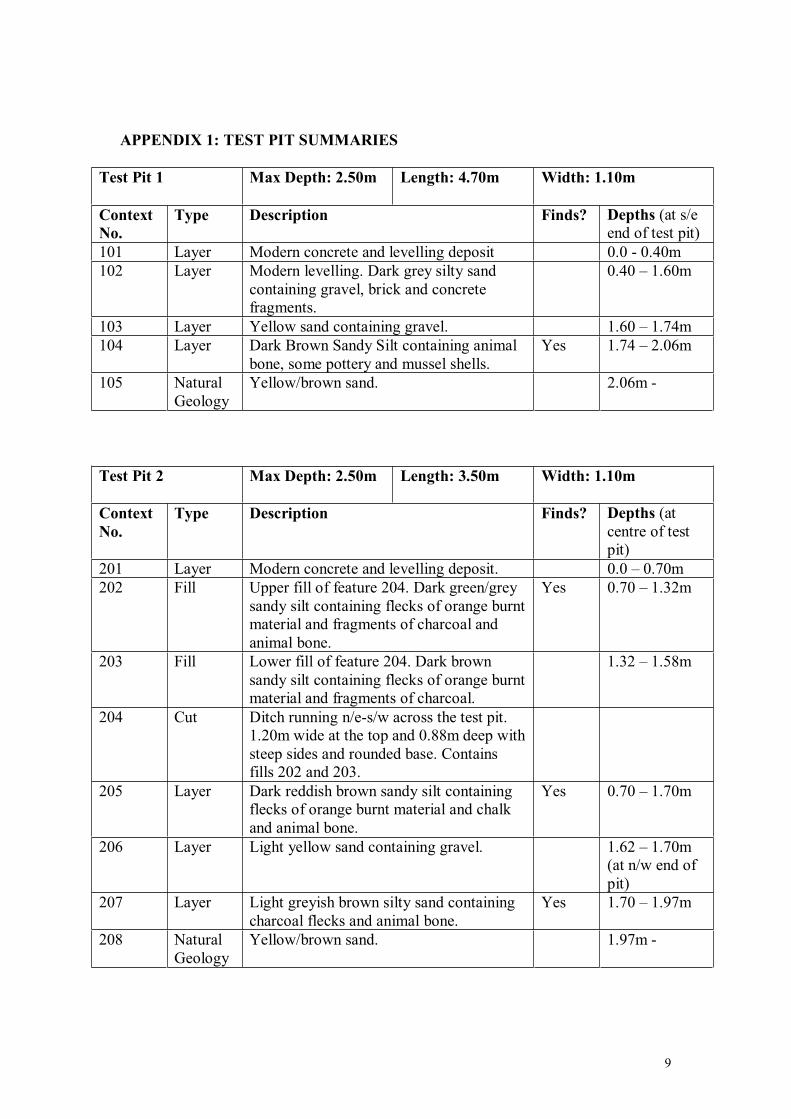
APPENDIX 1: TEST PIT SUMMARIES
Test Pit 1 Max Depth: 2.50m Length: 4.70m Width: 1.10m
Context No.
Type Description Finds? Depths (at s/e end of test pit)
101 Layer Modern concrete and levelling deposit 0.0 - 0.40m 102 Layer Modern levelling. Dark grey silty sand
containing gravel, brick and concrete fragments.
0.40 – 1.60m
103 Layer Yellow sand containing gravel. 1.60 – 1.74m 104 Layer Dark Brown Sandy Silt containing animal
bone, some pottery and mussel shells. Yes 1.74 – 2.06m
105 Natural Geology
Yellow/brown sand. 2.06m -
Test Pit 2 Max Depth: 2.50m Length: 3.50m Width: 1.10m
Context No.
Type Description Finds? Depths (at centre of test pit)
201 Layer Modern concrete and levelling deposit. 0.0 – 0.70m 202 Fill Upper fill of feature 204. Dark green/grey
sandy silt containing flecks of orange burnt material and fragments of charcoal and animal bone.
Yes 0.70 – 1.32m
203 Fill Lower fill of feature 204. Dark brown sandy silt containing flecks of orange burnt material and fragments of charcoal.
1.32 – 1.58m
204 Cut Ditch running n/e-s/w across the test pit. 1.20m wide at the top and 0.88m deep with steep sides and rounded base. Contains fills 202 and 203.
205 Layer Dark reddish brown sandy silt containing flecks of orange burnt material and chalk and animal bone.
Yes 0.70 – 1.70m
206 Layer Light yellow sand containing gravel. 1.62 – 1.70m (at n/w end of pit)
207 Layer Light greyish brown silty sand containing charcoal flecks and animal bone.
Yes 1.70 – 1.97m
208 Natural Geology
Yellow/brown sand. 1.97m -
9
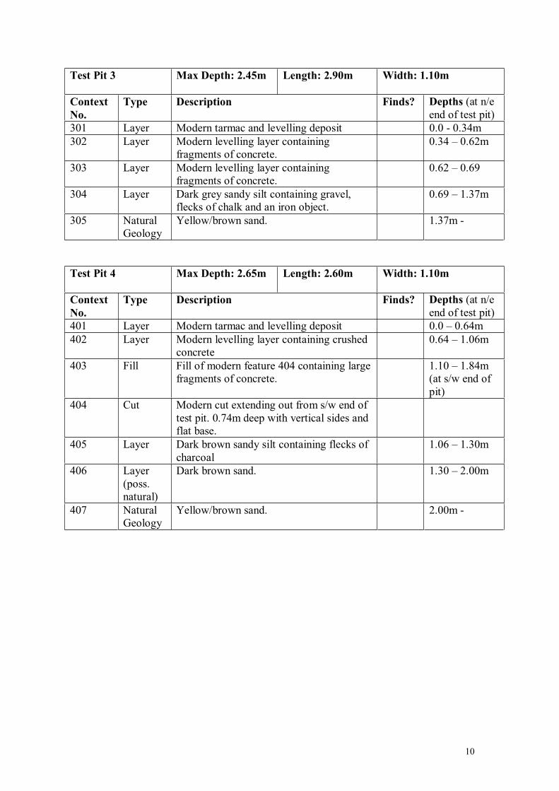
Test Pit 3 Max Depth: 2.45m Length: 2.90m Width: 1.10m
Context No.
Type Description Finds? Depths (at n/e end of test pit)
301 Layer Modern tarmac and levelling deposit 0.0 - 0.34m 302 Layer Modern levelling layer containing
fragments of concrete. 0.34 – 0.62m
303 Layer Modern levelling layer containing fragments of concrete.
0.62 – 0.69
304 Layer Dark grey sandy silt containing gravel, flecks of chalk and an iron object.
0.69 – 1.37m
305 Natural Geology
Yellow/brown sand. 1.37m -
Test Pit 4 Max Depth: 2.65m Length: 2.60m Width: 1.10m
Context No.
Type Description Finds? Depths (at n/e end of test pit)
401 Layer Modern tarmac and levelling deposit 0.0 – 0.64m 402 Layer Modern levelling layer containing crushed
concrete 0.64 – 1.06m
403 Fill Fill of modern feature 404 containing large fragments of concrete.
1.10 – 1.84m (at s/w end of pit)
404 Cut Modern cut extending out from s/w end of test pit. 0.74m deep with vertical sides and flat base.
405 Layer Dark brown sandy silt containing flecks of charcoal
1.06 – 1.30m
406 Layer (poss. natural)
Dark brown sand. 1.30 – 2.00m
407 Natural Geology
Yellow/brown sand. 2.00m -
10
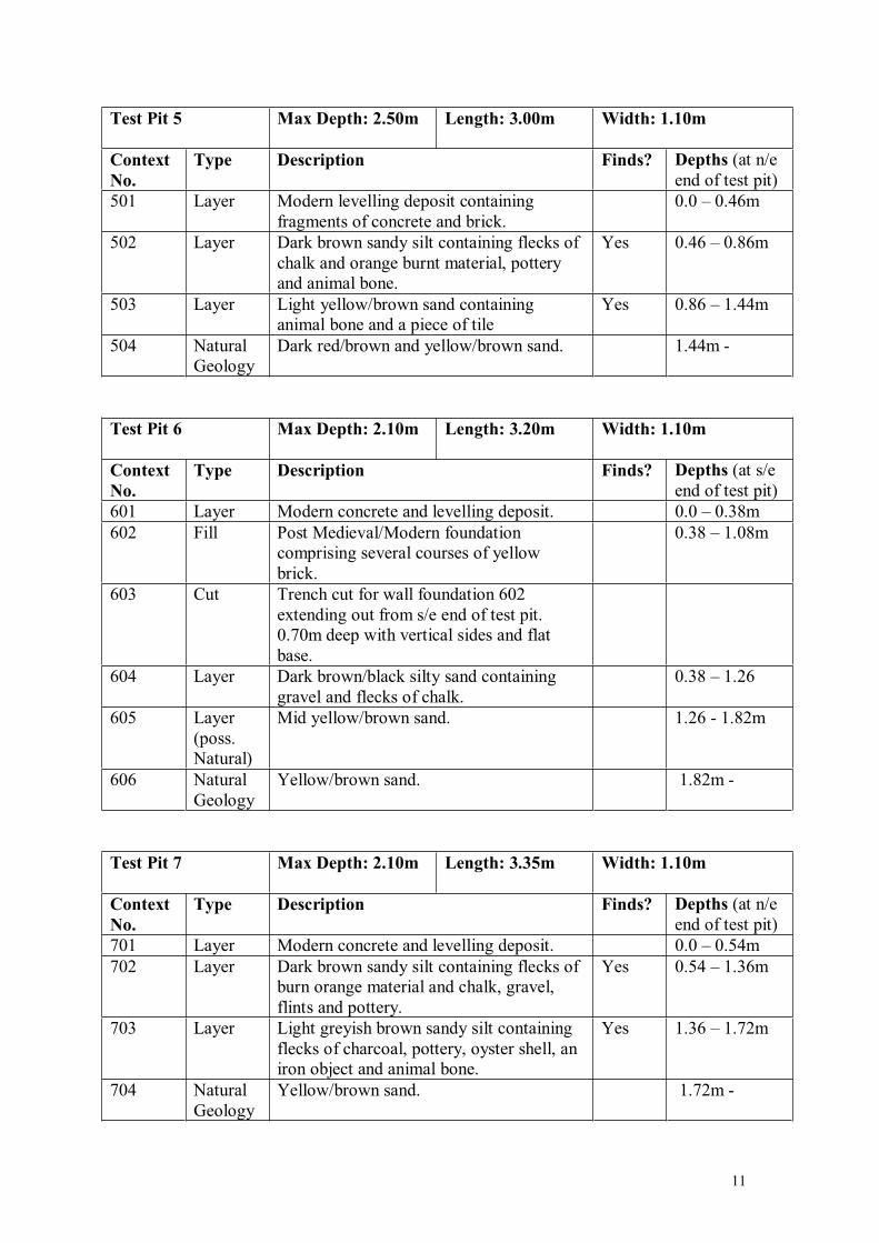
Test Pit 5 Max Depth: 2.50m Length: 3.00m Width: 1.10m
Context No.
Type Description Finds? Depths (at n/e end of test pit)
501 Layer Modern levelling deposit containing fragments of concrete and brick.
0.0 – 0.46m
502 Layer Dark brown sandy silt containing flecks of chalk and orange burnt material, pottery and animal bone.
Yes 0.46 – 0.86m
503 Layer Light yellow/brown sand containing animal bone and a piece of tile
Yes 0.86 – 1.44m
504 Natural Geology
Dark red/brown and yellow/brown sand. 1.44m -
Test Pit 6 Max Depth: 2.10m Length: 3.20m Width: 1.10m
Context No.
Type Description Finds? Depths (at s/e end of test pit)
601 Layer Modern concrete and levelling deposit. 0.0 – 0.38m 602 Fill Post Medieval/Modern foundation
comprising several courses of yellow brick.
0.38 – 1.08m
603 Cut Trench cut for wall foundation 602 extending out from s/e end of test pit. 0.70m deep with vertical sides and flat base.
604 Layer Dark brown/black silty sand containing gravel and flecks of chalk.
0.38 – 1.26
605 Layer (poss. Natural)
Mid yellow/brown sand. 1.26 - 1.82m
606 Natural Geology
Yellow/brown sand. 1.82m -
Test Pit 7 Max Depth: 2.10m Length: 3.35m Width: 1.10m
Context No.
Type Description Finds? Depths (at n/e end of test pit)
701 Layer Modern concrete and levelling deposit. 0.0 – 0.54m 702 Layer Dark brown sandy silt containing flecks of
burn orange material and chalk, gravel, flints and pottery.
Yes 0.54 – 1.36m
703 Layer Light greyish brown sandy silt containing flecks of charcoal, pottery, oyster shell, an iron object and animal bone.
Yes 1.36 – 1.72m
704 Natural Geology
Yellow/brown sand. 1.72m -
11
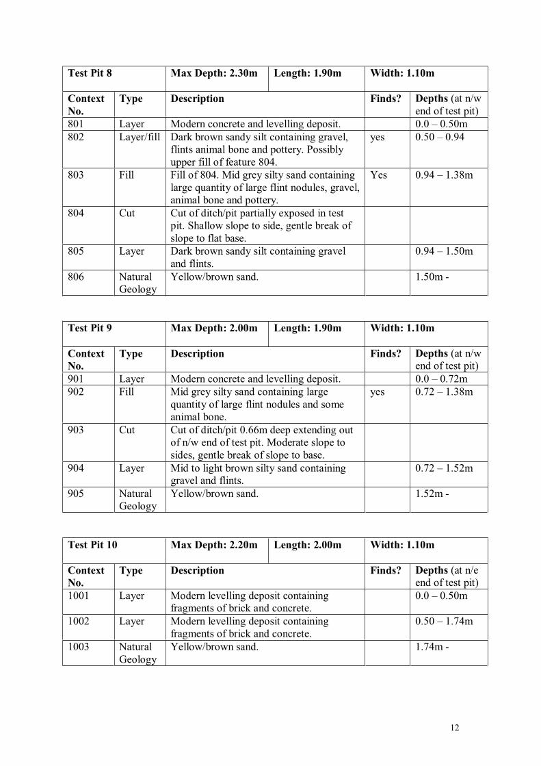
Test Pit 8 Max Depth: 2.30m Length: 1.90m Width: 1.10m
Context No.
Type Description Finds? Depths (at n/w end of test pit)
801 Layer Modern concrete and levelling deposit. 0.0 – 0.50m 802 Layer/fill Dark brown sandy silt containing gravel,
flints animal bone and pottery. Possibly upper fill of feature 804.
yes 0.50 – 0.94
803 Fill Fill of 804. Mid grey silty sand containing large quantity of large flint nodules, gravel, animal bone and pottery.
Yes 0.94 – 1.38m
804 Cut Cut of ditch/pit partially exposed in test pit. Shallow slope to side, gentle break of slope to flat base.
805 Layer Dark brown sandy silt containing gravel and flints.
0.94 – 1.50m
806 Natural Geology
Yellow/brown sand. 1.50m -
Test Pit 9 Max Depth: 2.00m Length: 1.90m Width: 1.10m
Context No.
Type Description Finds? Depths (at n/w end of test pit)
901 Layer Modern concrete and levelling deposit. 0.0 – 0.72m 902 Fill Mid grey silty sand containing large
quantity of large flint nodules and some animal bone.
yes 0.72 – 1.38m
903 Cut Cut of ditch/pit 0.66m deep extending out of n/w end of test pit. Moderate slope to sides, gentle break of slope to base.
904 Layer Mid to light brown silty sand containing gravel and flints.
0.72 – 1.52m
905 Natural Geology
Yellow/brown sand. 1.52m -
Test Pit 10 Max Depth: 2.20m Length: 2.00m Width: 1.10m
Context No.
Type Description Finds? Depths (at n/e end of test pit)
1001 Layer Modern levelling deposit containing fragments of brick and concrete.
0.0 – 0.50m
1002 Layer Modern levelling deposit containing fragments of brick and concrete.
0.50 – 1.74m
1003 Natural Geology
Yellow/brown sand. 1.74m -
12
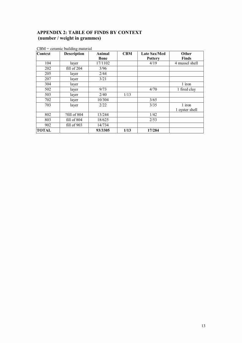
APPENDIX 2: TABLE OF FINDS BY CONTEXT (number / weight in grammes)
CBM = ceramic building material Context Description Animal
Bone CBM Late Sax/Med
Pottery Other Finds
104 layer 17/1102 4/19 4 mussel shell 202 fill of 204 3/96205 layer 2/44 207 layer 3/21 304 layer 1 iron 502 layer 9/73 4/70 1 fired clay 503 layer 2/40 1/13 702 layer 10/304 3/65 703 layer 2/22 3/35 1 iron
1 oyster shell 802 ?fill of 804 13/244 1/42803 fill of 804 18/625 2/53902 fill of 903 14/734
TOTAL 93/3305 1/13 17/284
13

Date: Revision Number:
Scale: Illustrator:
Path:
Digital data reproduced from Ordnance Survey data © Crown Copyright 2004 All rights reserved. Reference Number: 100020449.
This material is for client report only © Wessex Archaeology. No unauthorised reproduction.
01/03/04 0
1:400 MR
Y:\Projects\55490\Drawing Office\Report Figures (y-m)
Test Pit location plan Figure 2
Test Pit 5
Test Pit 1
Test Pit 9
Test Pit 2Test Pit 7
Test Pit 3
Test Pit 4
Test Pit 10
Test Pit 6
Test Pit 8
Footprint of formerVauxhall Garage
Newtown
St. M
ary's (Bury) R
oad
Previous EvaluationTrench 2
Previous EvaluationTrench 1
WessexArchaeology
Da
te:
Re
vis
ion
Nu
mb
er:
Sca
le:
Illu
str
ato
r:
Pa
th:
This
mate
rialis
for
clie
ntre
port
only
©W
essex
Arc
haeolo
gy.
No
unauth
orised
repro
duction.
05
/03
/04
0
1:5
0M
R
Y:\
Pro
jects
\55
49
0\D
raw
ing
Offic
e\R
ep
ort
Fig
ure
s
Tes
tP
its
sect
ions
Fig
ure
3
Wes
sex
Arc
haeo
logy
SE
NW
Te
st
Pit
2-
Se
cti
on
20
1
20
2
20
3
20
7
20
8
20
6
20
5
20
4
Co
ncre
te
SW
NE
Te
st
Pit
7-
Se
cti
on
Co
ncre
te7
01
70
2
70
3
70
4
SE
NW
Te
st
Pit
9-
Se
cti
on
90
1
90
4
90
5
90
2
90
3
Co
ncre
te
SE
NW
Te
st
Pit
8-
Se
cti
on
80
4
Co
ncre
te8
01
80
2
80
3
80
6
80
5
20
4
NE
SW
Te
st
Pit
1-
Se
cti
on
10
2
10
3
10
4
10
5
10
1C
on
cre
te
SW
NE
Te
st
Pit
3-
Se
cti
on
Ta
rma
c3
01
30
2
303
30
4
30
5
SW
NE
Te
st
Pit
4-
Se
cti
on
Ta
rma
c
40
4
40
1
40
2
40
5
40
6
40
7
40
3
NE
SW
Te
st
Pit
5-
Se
cti
on 50
1 50
2
50
3
50
4
SE
NW
Te
st
Pit
6-
Se
cti
on
Co
ncre
te
60
4
60
2
60
5
60
6
60
1
60
3
SW
NE
Te
st
Pit
10
-S
ec
tio
n
1001
10
02
10
03
(Na
tura
l)
(Mo
de
rn)
(Na
tura
l)
(Na
tura
l)
(Na
tura
l)
(Na
tura
l)
(Na
tura
l)
(Na
tura
l)
(Na
tura
l)
(Na
tura
l)(N
atu
ral)
(Mo
de
rn)
(Mo
de
rn)
(Mo
de
rn)
(Mo
de
rn)
(Mo
de
rn)
(Mo
de
rn)
(Mo
de
rn)
(Mo
de
rn)
(Mo
de
rn)
(Mo
de
rn)
(Mo
de
rn)
(Mo
de
rn)
(Mo
de
rn)
(Mo
de
rn)
(Mo
de
rn)
(Mo
de
rn)
(Mo
de
rn)
(Mo
de
rn)
(Mo
de
rn)
02
m

THE TRUST FOR WESSEX ARCHAEOLOGY LTD.Portway House, Old Sarum Park, Salisbury, Wiltshire SP4 6EBTel:(01722) 326867 Fax:(01722) 337562E-mail:[email protected] www.wessexarch.co.uk
Registered as an archaeological organisation with the Institute of Field ArchaeologistsRegistered Charity No. 287786. A company with limited liability registered in England No. 1712772