Embed Size (px)
Citation preview

Forest Area Rationalization in Indonesia: A Study on The Forest Resource Condition
and Policy Reform
Harry Santoso
Developing Mechanisms forRewarding the Upland Poor in Asia for Environmental Services They Provide


Published in 2003 The Program for Developing Mechanisms for Rewarding the Upland Poor in Asia for Environmental Services They Provide (RUPES) is supported by the International Fund for Agricultural Development (IFAD). Published by: World Agroforestry Centre (ICRAF) Southeast Asia Regional Office PO Box 161, Bogor 16001, Indonesia Tel: +62 251 625415, 625417; fax: +62 251 625416, email: [email protected] ICRAF SEA webstite: http://www.worldagroforestrycentre.org/sea Layout by: Kusuma Wijaya Cover design by: Dwiati Novita Rini


TABLE OF CONTENTS
INTRODUCTION..................................................................................................................................................... 1 Background Issues.............................................................................................................................................. 1 Definition of Specific Term .............................................................................................................................. 2 Methodology ....................................................................................................................................................... 2
THE PROGRESS OF DATA OF FOREST AREA IN INDONESIA: LEGAL BASIS, POLICY AND PROBLEMS ................................................................................................................................................................ 3
Forest Land use and Solidification Plan (RPPH)/Forest Land use by Concensus (TGHK) ..................... 3 Provincial Spatial Plan (RTRWP)....................................................................................................................... 4 Synchronization of TGHK and RTRWP....................................................................................................... 5 Designation of Forest Area and Ocean Conservation Area...................................................................... 8
THE PROGRESS OF FOREST COVER AREA DATA IN INDONESIA ..................................................... 9 Statistics of Indonesia’s Forest Resources.................................................................................................... 9 Recalculation of Forest Resources.................................................................................................................. 10 Master Plan of Land and Forest Rehabilitation ............................................................................................. 12
REASON FOR THE GOVERNMENT TO MANAGE FOREST AREA ........................................................ 14 Judicial Aspect..................................................................................................................................................... 14 Environmental Aspects...................................................................................................................................... 18 Social Economic Aspects .................................................................................................................................. 20
JUSTIFICATION FOR RATIONALIZATION OF FOREST AREAS BASED ON LAND COVERAGE AND FOREST AREA DATA.................................................................................................................................. 21
Land Coverage in Forest Areas...................................................................................................................... 21 The Results of Overlaying of Forest Cover Map with Forest Area Designation Map : Cases of Lampung, West Kalimantan and East Kalimantan Provinces..................................................... 21 Potential Forest Areas Worthy of Being Maintained .................................................................................. 24 Potential Forest Areas Whose Management Can be Surrendered to the Community ....................... 26
JUSTIFICATION OF IMPLEMENTION SCENARIO AND POLICY REFORM ........................................ 27 Implementation Scenario for Rationalization of Forest Areas................................................................... 27 Solidification of Forest Areas: Current Policy, Conditions and Problems, Policy Reform and Implication.................................................................................................................................................... 29 Change of Status and Function of Forest Area: Current Policy, Condition and Problems, Policy Reform and Implication........................................................................................................................ 30


INTRODUCTION
Background Issues 1. The newest official data publicized by the
Ministry of Forestry about the area of state forest area (hereinafter called forest area) in Indonesia at this moment is data as the result of synchronization of forest land use by consensus (TGHK) and provincial spatial plan (RTRWP) year 1999, i.e. an area of + 120.35 million Ha (MOFEC, 2001). Total area of this forest area covers + 62% of total land area of Indonesia. Data of forest area is used because it covers the whole provinces (former provinces) in Indonesia, so that it is suitable as national data. Meanwhile data as the result of designation of forest area and ocean conservation area as follow up of the result of the above synchronization, up to this moment is still leaving processes for 3 (three) provinces (North Sumatera, Riau and Central Kalimantan) which have no decree of the Minister of Forestry yet, so that it cannot be used as national data yet. Nevertheless it can be estimated that forest area in Indonesia will change later if data as the result of designation of forest area and ocean conservation area will be used , i.e if all provinces have been completed.
2. Aside of the change which occurred in the use of different data sources, forest area in Indonesia is basically susceptible to changes following the process of spatial management and regional autonomy at this moment. Looking at empirical fact, at least there are 2 (two) driving factors which can cause change in Indonesia’s forest area.
a. Juridical factor, i.e. the progress of law and regulation, with different impacts in the period (i). before and after the legislation of Law No.24 of 1992 about Spatial Use Management; and (ii).before and after the legislation of Law No.22 of 1999 about Regional Governance.
b. Dynamic factor, i.e. the facts that naturally the phenomena of spatial change of land use is dynamic in nature and it is determined by: (i). social value system which directly or indirectly influences forest land use, and (ii). government policy (central and/or local) in the implementation of development which has direct or indirect impact on forest land use.
3. The phenomena of susceptibility of Indonesia’s forest area to change mentioned above, gives an indication about many constraint to the claim of state control of the forest area in Indonesia. So that the implementation of this study concerning forest area rationalization is quite reasonable. More specifically, background of problems can be mentioned below, which encourage the implementation of this study.
a. There are plenty of forest area control by the state (read: government) in de jure1 but de facto in the field there are still many problems.
b. Rate of deforestation in Indonesia keeps showing the tendency to increase, i.e. 0.90 million Ha/year in the period of 1982 – 1990, excluding forest fire in East Kalimantan 1982-1983 (Ministry of Forestry, 1997) while in the period 1987-1997 it has reached + 1.6 million Ha/year(4 (Forestry Planning Agency, 1999).
c. Urgency to synchronize policy and perception in arrangement and management of forest area between central government and regional/local government in the era of regional autonomy.
d. The fact of growing claim for control of land (land tenure) in forest area by the community including claim of community right.
4. In relation to that, the World Bank (by consultation with several parties included ICRAF) has initiated a preliminary study about forest area rationalization in Indonesia. The result of this study will be used as country strategy for the World Bank to give input for the policy of Indonesian Government in arrangement and management of forest area. In the framework of giving contribution of idea concerning the topic of the study, the author prepares this paper as one of contributors from several members of the study team, each with different focus of study.
1 In Article 14 of Law No.41 of 1999 about Forestry, this
authority of control of forest area by the state is delegated to the Government to regulate and manage forest, forest area and forest products, determine the status of certain area as forest area or forest area as non forest area as well as arranging and determine legal relation between man and forest as well as arranging legal acts concerning forestry.
2 This figure is calculated using data of forest vegetation cover coming from RePPProt and result of Interpretation of satellite image Landsat which is available during the period 1985/1986 until 1997/1998, excluding the regions Java, Bali, NTT, NTB, and Maluku.
2
RUPES Indonesia/National Level Inception Workshop
Definition of Specific Term 5. In the framework of giving contribution of
positive thinking, rational and objective ideas in the scope of knowledge and experience of the author, this paper is started with presentation of chronological data of forest area, then the progress of forest cover data, and analysis of the reason why the Government to control the plenty of forest area, justification of forest area rationalization, and the proposal for Government’s policy reform.
6. Before entering main substances, first it is necessary to have the same perception about definition of “state forest area” (hereinafter called “forest area”) in the title of this paper, in order not to create different interpretation. The understanding “forest area” is as mentioned in article 1 of Law No.41 of 1999 about Forestry which is defined as follows: “Forest area is certain area which is designated (ditunjuk) and or officially legalized (ditetapkan) by the Government to be maintained its existence as permanent forest”.
7. The understanding of certain area which is designated by the Government as permanent forest, the process is carried out through state forest area designation (penunjukan kawasan hutan) by Minister of Forestry which in practice covers 2 (two) types, i.e.:
a. Designation of provincial region forest area; and
b. Designation of partial forest area per forest groups.
8. While the understanding of certain area which is legalized by the Government as permanent forest, in the implementation through a process called solidification of forest area (pengukuhan kawasan hutan) which is in article 15 paragraph 1 of Law No. 41 of 1999 about Forestry covering the activities:
a. Designation of forest area, as has been described in point 6 above;
b. Boundary demarcation and mapping of forest area, which are carried out by Forest Boundary Demarcation Team which is chaired by Head of District/Municipal (Bupati/Walikota) and presented in an Official Report of Forest Boundary Demarcation (Berita Acara Tata Batas Kawasan Hutan= BATB), and
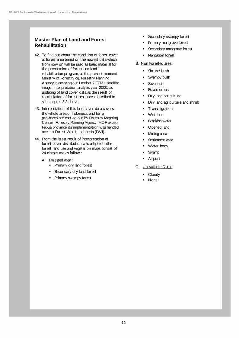
c. State Forest Gazettement, in form of legalization of BATB mentioned in point b above with a decree of the Minister of Forestry.
9. The term “state forest” refers to article 5 Law No.41 of 1999 about Forestry, concerning forest classification based on its status consists of :
a. State forest (hutan negara) is a forest lies on the land which has not burdened with right of land; and
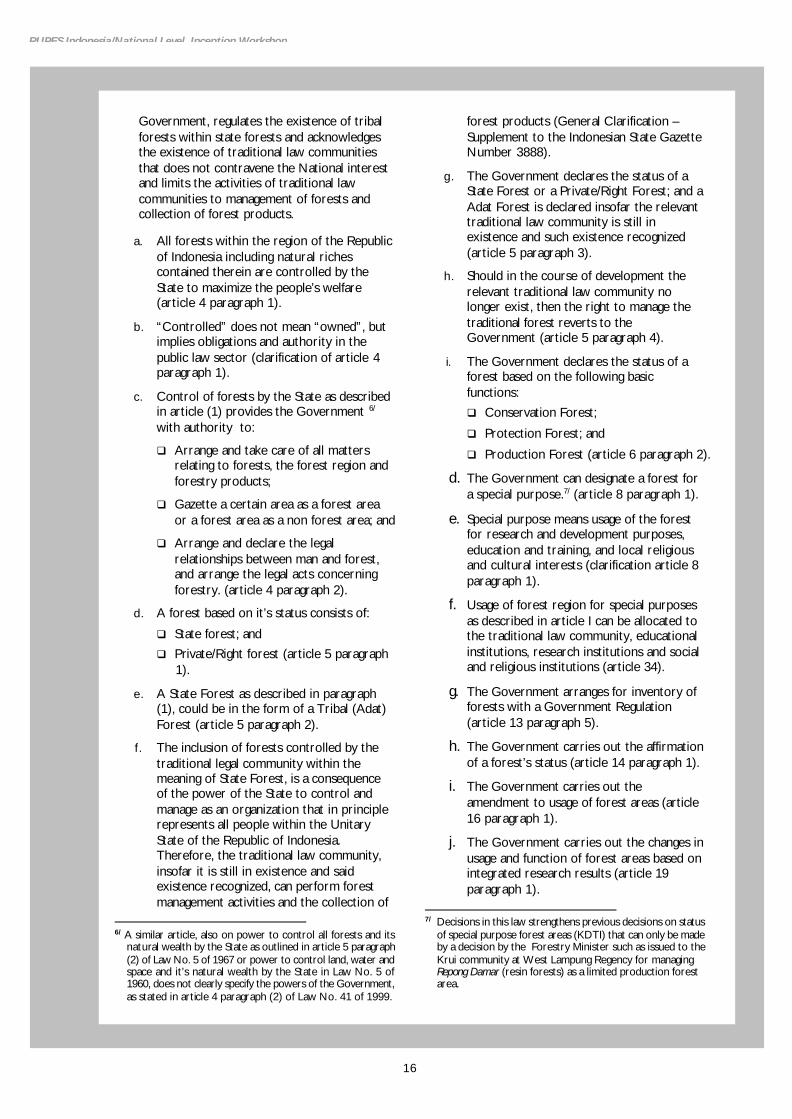
b. Private forest (hutan hak) is a forest lies on the land wich has burdened with right of land.
10. Term of “forest area rationalization” in the title of this paper has positive meaning for the realization of sustainable stewardship and management of forest area in participatory, transparent and accountable way, by considering rationality and professionalism of capability in management, control, distribution of authority, harmony with the existing laws and regulations, as well as dynamics of national social-economic-political development towards the achievement of a prosperous and justice civil society.
Methodology 11. With the limited time period of this study,
presentation of this paper aside of relying on knowledge and experience of the author, is also supported by the result of field visits (in Lampung province), intensive discussion with several related parties such as experts, government officials, NGO, international institution, as well as the result of discussion in multi-stakeholder workshop.

Jakarta, Indonesia, 8-9 October 2002
THE PROGRESS OF DATA OF FOREST AREA IN INDONESIA: LEGAL BASIS, POLICY AND PROBLEMS
Forest Land use and Solidification Plan (RPPH)/Forest Land use by Concensus (TGHK)
12. Efforts of spatial management in Indonesia has started since The Fifth Year Development Plan (Repelita) I with the development of spatial plan in various form, for example General Plan of City Development and Master Plan of City, Industrial Growth Center Area, Jabotabek Development Area, Gerbangkertasusila, Bandung Raya, etc. In forestry sector RPPH has been developed, enclosed with maps for all provinces in Indonesia, which for outside of Java island it is known as Tata Guna Hutan Kesepakatan (TGHK). In general, all the efforts are in form of determining physical zoning delineation of spatial utilization for various business interests and natural /environmental conservation.
13. RPPH or TGHK (hereinafter called TGHK) is developed as elaboration of Law No.5 of 1967 about Main Provisions of Forestry, Government Regulation (Peraturan Pemerintah = PP) No.33 of 1970 about Forest Planning, and several Decrees of the Minister of Agriculture No.837/Kpts/Um/11/1980,No.680/Kpts/Um/8/1981,No.681/Kpts/Um/8/1981,No.682/Kpts/Um/11/1981, and No.683/Kpts/Um /8/1981.
14. The forest area in Indonesia based on TGHK is 141,774,427 Ha (Statistics of Indonesian Forestry 1990/1991) or + 73.55% of land area of Indonesia (192,738.878 Ha) as presented in Table-1.
15. The TGHK map is 1 : 500,000 scale which shows delineation of forest area designation for provincial area according to functions of forest which are macro and indicative in nature, which is prepared with the available data/information, then discussed together, agreed/signed by various head of related agencies at provincial level as well as legalized by Governor. After that, the documents and maps were sent to Ministry of Agriculture/Forestry to be discussed and then legalized by Minister of Agriculture/Forestry. Designation of forest area represents initial setting of allocation of a certain area as forest area.
16. Criteria of area which can be designated as forest area based on TGHK are:
a. Having natural vegetation;
b. State land which has not burdened with right or controlled by certain land user;
c. Area with bio-geophysical condition has the function to protect hydrological condition of the lower watershed;
d. Area with natural resource phenomena which suitable for conservation area;
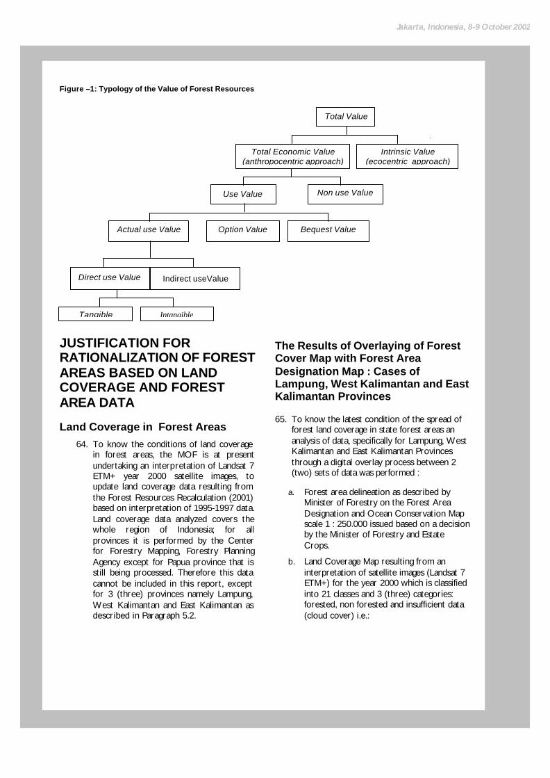
e. Other consideration covering socio-economic, law, as well as defense and security aspects.
17. For more than 10 (ten) years, operationally at every province forest area designation map of TGHK has been used as basic reference for: (i) solidification of forest area covering (new) designation, boundary demarcation and gazettment of forest area; and (ii) forest land use which cover forest utilization (HPH, HPHTI, HPPA, social forestry etc.), releasing forest area for non forestry purposes (settlement/transmigration, estate crops plantation, agriculture, industry etc.), and leasing of forest area for mining, road, etc. and
18.
No Forest Function Area (Ha)
1 Nature Reserve and Tourism Forest 19,152,885
2 Protection Forest 29,649,231
3 Limited Production Forest 29,570,656
4 Permanently Production Forest 33,401,655
5 Convertible Production Forest 30,000,000
T O T A L 141,774,427
Source : Ministry of Forestry (1992 )
Table-1. Indonesian Forest Area based on TGHK

4
RUPES Indonesia/National Level Inception Workshop
exchange of forest area. Therefore the use of TGHK map as forest planning instrument has given various implication, i.e. juridical, bio-physical and technical as well as socio-economic in regional, sectors and community development.
19. With the passing of time, various problems arose in using TGHK map as reference for development planning in the region, i.e.:
a. Overlapping in the forest land use i.e. among forest concession areas and between forest concession area and protection forest / conservation forest area.
b. Conflicts among forest concession area and protection forest / conservation forest area with community rights area which claim forest land including customary/traditional right (hak-hak masyarakat hukum adat / tanah ulayat).
c. Overlapping of forest areas with town/sub-district/village administrative area.
d. Conflict in land use/utilization of forest area among development sectors (forestry, plantation, transmigration, mining etc.)
20. The problems were caused by many factors, yet it was realized it is also caused by the weakness in the making and using of TGHK map as reference for planning. Several weaknesses which can be mentioned are:
a. At the time of the establishment TGHK map, awareness and need for spatial utilization of various land user agencies/institutions other than forestry agency are not quite pressing yet, so that control mechanism on the process and result of the establishment was not quite tight.
b. In the establishment of TGHK map they were not supported with forest vegetation cover data and community right claim map on land/forest area.
c. TGHK map is established with reconnaissance map scale, so its usage is in macro and indicative scale.
d. Establishment of TGHK map only involving related agencies, but did not the involving interested agencies/community groups.
Provincial Spatial Plan (RTRWP) 21. The increasing number of population and
dynamic mobility of the people which follow economic and social activities has pushed the establishment of spatialpattern according to each interest. So settlement grows on steep slope, in the middle of natural forest, around mangrove, riverbanks, along the beach, on water reserve area etc. Development activities and community movement which are getting more dynamic have created conflicts in land and forest land use which get more and more complicated to overcome so as to create social and cultural problems. Various sectors carry out development in the same space each by using law and regulation for their sector as reference, so that overlapping in land use occurred and often creating sharp conflicts in the field.
22. In the effort to increase efficiency of spatial utilization, spatial quality, harmony of spatial utilization with environment, harmony in regional growth, development equalization, national unity and integrity as well as social welfare, Law No.24 of 1992 about Spatial Use Management was issued. This law was drafted to integrate various spatial arrangement which is sector oriented in nature into one unitary which is mutually integrated and give place to all sectors and all people as well as maintaining the function of environment. To regulate coordination in national spatial use management Presidential Decree No.75 of 1993 about National Spatial Use Management Coordination was legislated, which establish Coordinating Board for National Spatial Use Management (Badan Koordinasi Tata Ruang Nasional = BKTRN) chaired by State Minister for National Development Planning/Chairman of BAPPENAS with members the related ministers (excluding Ministry of Forestry3). Chairman of BKTRN then establishes a Working Group for National Spatial Use Management (POKJA Tata Ruang Nasional=POKJA TRN) with Decree No.KEP.021/KET/5/1994 (excluding officials from Ministry of Forestry).
3 The reason for not including Minister of Forestry as member
of BKTRN they said because Ministry of Forestry was considered as land user agency, so he was considered to have interest and will be difficult to act objectively in solution of spatial utilization conflicts. This is quite unreasonable if we consider the urgency of problem solution which should actually go through consultative process mechanism which involving multi stakeholder.

Jakarta, Indonesia, 8-9 October 2002
23. Based on Law No.24 of 1992 about Spatial Use Management, all provinces are obliged to prepare RTRWP which represent strategy and structure of spatial utilization in provincial region, containing guidance for management of protected area and cultivation area, urban and rural area as well as specific area, for a period of 15 years and legislated with Regional Regulation (Peraturan Daerah=PERDA).
24. After PERDA RTRWP is established at several provinces, many problems were encountered in delineating forest function in RTRWP map, so that many disharmony occurred with delineation of forest functions in TGHK map. Conspicuous problems in RTRWP map are:
a. There are many forest areas which have been designated, boundary demarcated, and gazetted by Minister of Forestry, but in RTRWP map which are not delineated as forest area.
b. There are many forest utilization concession areas with permits which are not expired yet, in the map of RTRWP their areas were directed into other uses.
q There were change of status and function of forest shown in the RTRWP map.
q Area with natural forest was directed as not forest area, while area without natural forest was directed as forest area.
q Several RTRWP map did not mentioned terminology of forest functions in accordance with the existing laws and regulations, either in the legend or on the map.
25. Forest area based on RTRWP map all over Indonesia cannot be presented because at the time of the preparation of RTRWP in every province was still in the process of implementation, meanwhile in a separate activities synchronization of TGHK and RTRWP through the initiative of Ministry of Forestry had been carried out; so that recapitulation data of RTRWP in all provinces was never documented completely.
Synchronization of TGHK and RTRWP 26. Based on awareness of the necessity to
synchronize TGHK map and RTRWP map in all provinces, Spatial Study Team of Ministry of Forestry was established with Decree of Minister of Forestry No.726/Kpts-II/93 dated 8 November 1993 and improved with Decree of Minister of Forestry No.20/Kpts-II/1994 dated 11 January 1994. Activities of this Study Team of Ministry of Forestry was called ‘Synchronization of TGHK and RTRWP’(Pemaduserasian TGHK dan RTRWP). With the passing of time, these activities got political support with the issuance of:
a. Instruction of Minister of Home Affairs No.474/4263/Sj dated 27 December 1994 to all Governors in Indonesia to carry out synchronization of TGHK and RTRWP, and the result to be used as material to review RTRWP.
b. State Minister for National Development Planning/Chairman of BAPPENAS No.KEP.001/KET/1/1995 about Technical Team of National Spatial Use Management (Tim Teknis Tata Ruang Nasional), which included the activities of synchronizing TGHK and RTRWP as one the agenda of the Tasks of Technical Team II coordinated by the Ministry of Home Affairs (MOHA).
27. Implementation of work mechanism of Synchronization of TGHK and RTRWP organized by Directorate General of Forest Land Use and Inventory (DG of INTAG) as a lead agency in the Ministry of Forestry (MOF), are as follows:
a. Period-I : February 1994 up to April 1995 (mechanism of sectoral forum)
q If RTRWP has been established in PERDA, MOF conducts synchronization discussion at central level by inviting related agencies at central level, Chairman of Provincial BAPPEDA, Head of Provincial BPN, Head of Regional
6
RUPES Indonesia/National Level Inception Workshop
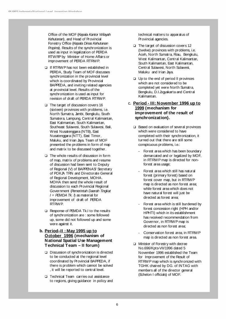
Office of the MOF (Kepala Kantor Wilayah Kehutanan), and Head of Provincial Forestry Office (Kepala Dinas Kehutanan Propinsi). Results of the synchronization is used as input in legalization of PERDA RTWRP by Minister of Home Affairs or improvement of PERDA RTRWP.
q If RTRWP has not been established in PERDA, Study Team of MOF discusses synchronization in the provincial level which is coordinated by Provincial BAPPEDA, and inviting related agencies at provincial level. Results of the synchronization is used as input for revision of draft of PERDA RTRWP.
q The target of discussion covers 16 (sixteen) provinces with problems, i.e. North Sumatra, Jambi, Bengkulu, South Sumatera, Lampung, Central Kalimantan, East Kalimantan, South Kalimantan, Southeast Sulawesi, South Sulawesi, Bali, West Nusatenggara (NTB), East Nusatenggara (NTT), East Timor, Maluku, and Irian Jaya. Team of MOF presented the problems in form of map and matrix to be discussed together.
q The whole results of discussion in form of map, matrix of problems and resume of discussion had been sent to Deputy of Regional (V) of BAPPENAS/ Secretary of POKJA TRN and Directorate General of Regional Development, MOHA. MOHA then send the whole result of discussion to each Provincial Regional Government (Pemerintah Daerah Tingkat I = PEMDA Tk. I) as material for improvement of draft of PERDA RTRWP.
q Response of PEMDA Tk.I to the results of synchronization are : some followed up, some did not followed up and some were against it.
b. Period–II : May 1995 up to October 1996 (mechanism of National Spatial Use Management Technical Team – II forum)
q Discussion of synchronization is directed to be conducted at the regional level coordinated by Provincial BAPPEDA, if there is problem which cannot be solved , it will be reported to central level.
q Technical Team carries out assistance to regions, giving guidance in policy and
technical matters to apparatus of Provincial agencies.
q The target of discussion covers 12 (twelve) provinces with problems, i.e. Aceh, North Sumatra, Riau, Bengkulu, West Kalimantan, Central Kalimantan, South Kalimantan, East Kalimantan, Central Sulawesi, North Sulawesi, Maluku and Irian Jaya.
q Up to the end of period II provinces which are not considered to be completed yet were North Sumatra, Bengkulu, D.I.Jogyakarta and Central Kalimantan.
c. Period - III: November 1996 up to 1999 (mechanism for improvement of the result of synchronization).
q Based on evaluation of several provinces which were considered to have completed with their synchronization, it turned out that there are still some conspicuous problems, i.e.:
- Forest area which has been boundary demarcated and or legalized by MOF, in RTRWP map is directed for non-forest area usage;
- Forest area which still has natural forest (primary forest) based on forest cover map, but in RTRWP map is directed as non forest area; while forest area which does not have natural forest will just be directed as forest area;
- Forest area which is still burdened by forest concession right (HPH and/or HPHTI) which in its establishment has received recommendation from Governor, in RTRWP map is directed as non forest area;
- Conservation forest area, in RTRWP map is directed as non forest area.
q Minister of Forestry with decree No.696/Kpts-VII/1996 dated 5 November 1996 established the Team for Improvement of the Result of RTRWP map which is synchronized with TGHK chaired by DG. of INTAG with members all of the director general (Echelon I officials) of MOF.

Jakarta, Indonesia, 8-9 October 2002
q Target of study are 8 (eight) provinces with problems i.e. East Kalimantan, Central Kalimantan, West Kalimantan, South Kalimantan, Aceh, North Sumatera, Riau and Bengkulu.
q Result of the meeting coordinated by POKJA TRN by inviting officials from the 8 (eight) provinces i.e. Chairman of Bappeda-I, Head of Regional Office of BPN, Head of Regional Office of MOF, Head of Forestry Services, and Echelon I officials of the related ministries/agencies, the important ones are:
- RTRWP regulates directions of spatial function in protected area and cultivation area, and does not regulates rights of land/forest;
- Direction of spatial function must respect the existing rights/permits given by government until expiration of the rights/permits;
- RTRWP which has been established in PERDA if it contains regulations which violate the prevailing regulations, the PERDA is not valid;
- RTRWP which has been established in PERDA and legalized by Minister of Home Affairs can still be valid, except for locations with problems and should be declared as status quo until the problems are solved.
- Activities of Synchronization of TGHK and RTRWP was declared to be finished in 1999.
28. Forest area based on the result of Synchronization of TGHK and RTRWP (Forestry Planning Agency, 1999) was 120,353,104 Ha as presented in Table-2.
29. By comparing area data of forest area based on TGHK and data as the result of Synchronization of TGHK and RTRWP the following things can be presented:
a. Total area of forest area in Indonesia decreased drastically, i.e.+ 21,421,323 Ha.
b. Area reduction occurred at Limited Production Forest an area of + 6,513,207 Ha, and the biggest occurred at Convertible Production Forest, i.e. an area of + 21,921,944 Ha.
c. Reduction in area of production forest which can be conversed an area as in point b above caused by (Santoso, 2000):
q Presentation in TGHK map for provinces East Kalimantan, Central Kalimantan, Bali, NTB, and Maluku, area of Convertible Production Forest (HPK) is integrated with area of other uses (Areal Penggunaan Lain=APL), therefore area in TGHK map of 30,537,400 Ha was actually mixed with non forest area from the 5 (five) provinces.
q In the period of more than 10 (ten) years, part of the Convertible Production Forest (HPK) area has been released for non forest development such as estate crops plantation, transmigration/settlement, agriculture, industry etc.
q In synchronization of TGHK and RTRWP, some of the convertible forest (HPK) area has been changed into protection forest (HL), limited production forest (HPT) or permanent production forest (HP), and some others have changed their status into non forest uses (APL), as detailed in Attachment 1.
No Forest Function Area (Ha)
1 Nature Reserve / Nature Conservation / Hunting Park (KSA/KPA/TB) 20,500,988
2 Protection Forest (HL) 33,519,600
3 Limited Production Forest (HPT) 23,057,449
4 Permanently Production Forest (HP) 35,197,011
5 Convertible Production Forest (HPK) 8,078,056
T O T A L 120,353,104
Source : Forestry Planning Agency (1999)
Table-2. Area of Indonesian Forest Area based on the Result of Synchronization of TGHK and RTRWP
8
RUPES Indonesia/National Level Inception Workshop
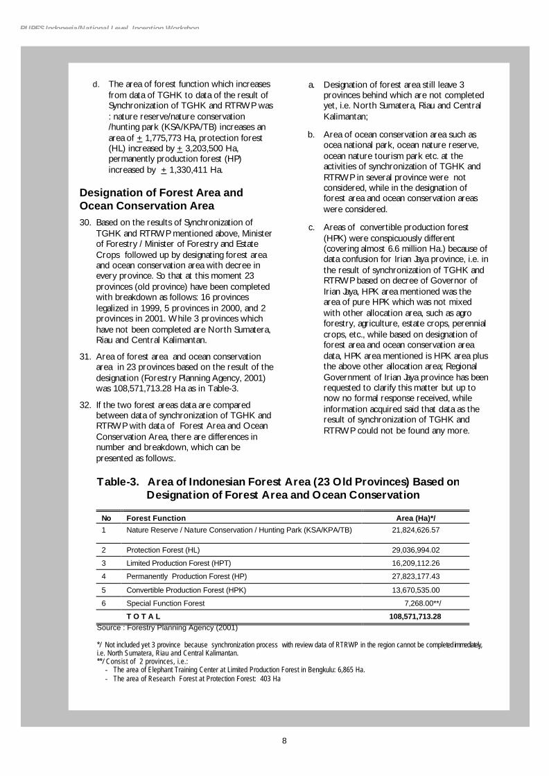
d. The area of forest function which increases from data of TGHK to data of the result of Synchronization of TGHK and RTRWP was : nature reserve/nature conservation /hunting park (KSA/KPA/TB) increases an area of + 1,775,773 Ha, protection forest (HL) increased by + 3,203,500 Ha, permanently production forest (HP) increased by + 1,330,411 Ha.
Designation of Forest Area and Ocean Conservation Area 30. Based on the results of Synchronization of
TGHK and RTRWP mentioned above, Minister of Forestry / Minister of Forestry and Estate Crops followed up by designating forest area and ocean conservation area with decree in every province. So that at this moment 23 provinces (old province) have been completed with breakdown as follows: 16 provinces legalized in 1999, 5 provinces in 2000, and 2 provinces in 2001. While 3 provinces which have not been completed are North Sumatera, Riau and Central Kalimantan.
31. Area of forest area and ocean conservation area in 23 provinces based on the result of the designation (Forestry Planning Agency, 2001) was 108,571,713.28 Ha as in Table-3.
32. If the two forest areas data are compared between data of synchronization of TGHK and RTRWP with data of Forest Area and Ocean Conservation Area, there are differences in number and breakdown, which can be presented as follows:.
a. Designation of forest area still leave 3 provinces behind which are not completed yet, i.e. North Sumatera, Riau and Central Kalimantan;
b. Area of ocean conservation area such as ocea national park, ocean nature reserve, ocean nature tourism park etc. at the activities of synchronization of TGHK and RTRWP in several province were not considered, while in the designation of forest area and ocean conservation areas were considered.
c. Areas of convertible production forest (HPK) were conspicuously different (covering almost 6.6 million Ha.) because of data confusion for Irian Jaya province, i.e. in the result of synchronization of TGHK and RTRWP based on decree of Governor of Irian Jaya, HPK area mentioned was the area of pure HPK which was not mixed with other allocation area, such as agro forestry, agriculture, estate crops, perennial crops, etc., while based on designation of forest area and ocean conservation area data, HPK area mentioned is HPK area plus the above other allocation area; Regional Government of Irian Jaya province has been requested to clarify this matter but up to now no formal response received, while information acquired said that data as the result of synchronization of TGHK and RTRWP could not be found any more.
Table-3. Area of Indonesian Forest Area (23 Old Provinces) Based on Designation of Forest Area and Ocean Conservation
No Forest Function Area (Ha)*/
1 Nature Reserve / Nature Conservation / Hunting Park (KSA/KPA/TB) 21,824,626.57
2 Protection Forest (HL) 29,036,994.02
3 Limited Production Forest (HPT) 16,209,112.26
4 Permanently Production Forest (HP) 27,823,177.43
5 Convertible Production Forest (HPK) 13,670,535.00
6 Special Function Forest 7,268.00**/
T O T A L 108,571,713.28 Source : Forestry Planning Agency (2001)
*/ Not included yet 3 province because synchronization process with review data of RTRWP in the region cannot be completed immediately, i.e. North Sumatera, Riau and Central Kalimantan. **/ Consist of 2 provinces, i.e.:
- The area of Elephant Training Center at Limited Production Forest in Bengkulu: 6,865 Ha. - The area of Research Forest at Protection Forest: 403 Ha
Jakarta, Indonesia, 8-9 October 2002
THE PROGRESS OF FOREST COVER AREA DATA IN INDONESIA
Statistics of Indonesia’s Forest Resources
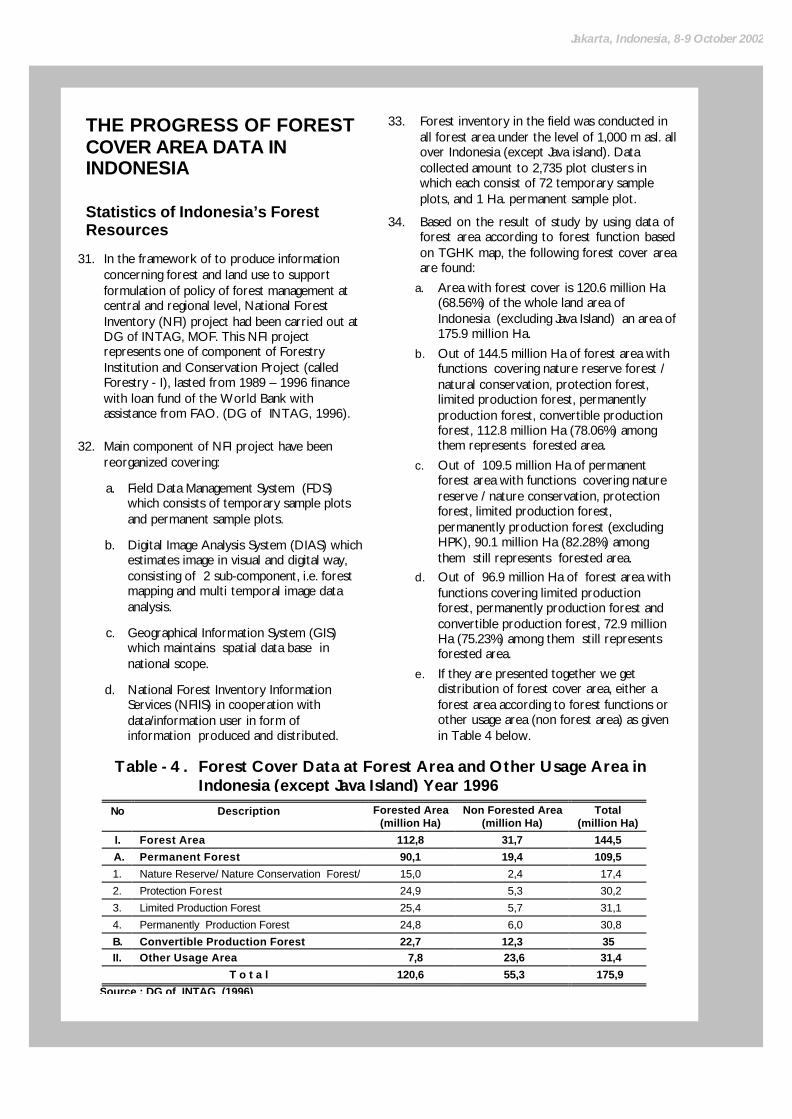
31. In the framework of to produce information concerning forest and land use to support formulation of policy of forest management at central and regional level, National Forest Inventory (NFI) project had been carried out at DG of INTAG, MOF. This NFI project represents one of component of Forestry Institution and Conservation Project (called Forestry - I), lasted from 1989 – 1996 finance with loan fund of the World Bank with assistance from FAO. (DG of INTAG, 1996).
32. Main component of NFI project have been reorganized covering:
a. Field Data Management System (FDS) which consists of temporary sample plots and permanent sample plots.
b. Digital Image Analysis System (DIAS) which estimates image in visual and digital way, consisting of 2 sub-component, i.e. forest mapping and multi temporal image data analysis.
c. Geographical Information System (GIS) which maintains spatial data base in national scope.
d. National Forest Inventory Information Services (NFIIS) in cooperation with data/information user in form of information produced and distributed.
33. Forest inventory in the field was conducted in all forest area under the level of 1,000 m asl. all over Indonesia (except Java island). Data collected amount to 2,735 plot clusters in which each consist of 72 temporary sample plots, and 1 Ha. permanent sample plot.
34. Based on the result of study by using data of forest area according to forest function based on TGHK map, the following forest cover area are found:
a. Area with forest cover is 120.6 million Ha (68.56%) of the whole land area of Indonesia (excluding Java Island) an area of 175.9 million Ha.
b. Out of 144.5 million Ha of forest area with functions covering nature reserve forest / natural conservation, protection forest, limited production forest, permanently production forest, convertible production forest, 112.8 million Ha (78.06%) among them represents forested area.
c. Out of 109.5 million Ha of permanent forest area with functions covering nature reserve / nature conservation, protection forest, limited production forest, permanently production forest (excluding HPK), 90.1 million Ha (82.28%) among them still represents forested area.
d. Out of 96.9 million Ha of forest area with functions covering limited production forest, permanently production forest and convertible production forest, 72.9 million Ha (75.23%) among them still represents forested area.
e. If they are presented together we get distribution of forest cover area, either a forest area according to forest functions or other usage area (non forest area) as given in Table 4 below.
No Description Forested Area (million Ha)
Non Forested Area (million Ha)
Total (million Ha)
I. Forest Area 112,8 31,7 144,5
A. Permanent Forest 90,1 19,4 109,5
1. Nature Reserve/ Nature Conservation Forest/ 15,0 2,4 17,4
2. Protection Forest 24,9 5,3 30,2
3. Limited Production Forest 25,4 5,7 31,1
4. Permanently Production Forest 24,8 6,0 30,8
B. Convertible Production Forest 22,7 12,3 35 II. Other Usage Area 7,8 23,6 31,4
T o t a l 120,6 55,3 175,9
Source : DG of INTAG (1996)
Table - 4 . Forest Cover Data at Forest Area and Other Usage Area in Indonesia (except Java Island) Year 1996

10
RUPES Indonesia/National Level Inception Workshop
35. Forest cover based on groups of big islands (except Java island) without separating forest area with other usage area, shows distribution of data of forest cover area of 120.6 million Ha. which consist of area of < 1,000 m asl. an area of 106.7 million Ha. and area of land > 1,000 m asl an area of 13.9 million Ha., complete details per island can be seen in Table 5.
Recalculation of Forest Resources
36. In the framework of updating forest cover data publicized in Statistics of Indonesia Forest Resources mentioned above, Forestry Planning Agency carries out the activities of Recalculation of Forest Resources in 2001 with APBN financing. Scope of these activities covered:.
a. Conservation Forest Area (KSA/KPA) and protection forest in Java Island and Outside Java Island, with sources from:
q Aerial portrait image and airborne radar image data 1992 – 1997 in 202 locations covering an area of 29.79 million Ha;
q Land cover map, scale 1 : 25,000 result of aerial portrait image interpretation 1996 – 1997.
q Land cover map, scale 1 : 25,000 result of airborne radar image interpretation 1997
b. Production Forest Area, i.e. HPH working area and Ex-Active HPH in big islands (except Java Island), with sources from:
q Result of interpretation of HPH Landsat image period April 1997 up to January 2000 in 320 units HPH an area of + 41.1 million Ha with the following breakdown: - 1997/1978: 124 HPH
- 1998/1999: 132 HPH
- 1999/2000: 64 HPH
38. Result of recalculation of forest cover data for nature reserve/nature conservation forest and protection forest showed that from the total area of forest area studied, i.e. 29,789,607 Ha. there are primary forest with an area of 17,433,655 Ha., which consist of 10,761,033 Ha. at nature reserve / nature conservation forest and an area of 6,672,622 Ha. at protection forest. Complete data can be seen in Table 6.
No Island Group Total
Area Studied (million Ha)
Area of Forest Cover <1000 m asl.
Area of Forest Cover >1000 m asl.
Total (Ha)
%
1. Sumatera 47,074 21,719 3,348 25,067 53,2
2. Kalimantan 53,028 36,772 1,790 38,562 72,7
3. Sulawesi 18,412 9,095 2,756 11,851 64,4
4. Maluku 7,809 6,397 206 6,603 84,6
5. Irian Jaya 40,759 30,405 5,618 36,023 88,4
6. Bali,NTB,NTT, Timtim 8,813 2,288 206 2,494 28,3
TOTAL 175,946 106,676 13,924 120,600 68,6
Source : DG of INTAG (1996)
Table - 5 . Area of Forest Cover per Island Group in Indonesia (except Java Island) Year 1996
Table – 6. Area of Forest Cover at Nature Reserve/Nature Conservation Forest and Protection Forest per Forest Function in Indonesia Year 2000
No. Forest Area Primary Forest (Ha)
Secondary Forest (Ha)
Non Forested (Ha)
Total (Ha)
A. Nature Reserve / Nature Conservation Forest 10,761,033 2,956,170 3,659,892 17,377,095
1. Nature Preserve 2,475,611 389,183 428,251 3,293,045
2. Fauna Reserve 2,867,228 516,384 1,755,840 5,139,452
3. Grand Forest Park /Hunting Park 49,922 82,786 76,708 209,416
4. National Park 5,368,272 1,967,817 1,399,093 8,735,182
B. Protection Forest 6,672,622 3,576,835 2,163,055 12,412,512
T O T A L 17,433,655 6,533,005 5,822,947 29,789,607
Source: Forestry Planning Agency (2001)

Jakarta, Indonesia, 8-9 October 2002
39. Data of forest cover area at nature reserve / nature conservation forest area per Island Group is as presented in Table 7. The biggest primary forest cover is found in Irian Jaya island, followed by Kalimantan, Sumatera and Sulawesi.
40. Meanwhile for the result of recalculation at Production Forest area data of forest cover according to primary forest category, log over area (fair – good) and damaged forest/empty land separated based on HPH area and ex-HPH area as presented in Table 8. Condition of damaged forest can be clearly seen at ex HPH area, i.e. HPH which has been terminated and
handed over its management to PT INHUTANI I – V, where only 0.6 million Ha. of primary forest left or 11 % of the overall area recalculated. While at HPH area which is still in operation the balance of primary forest is 18,3 million Ha. or 45 % of total area studied.
41. Forest cover at production forest area at HPH area per big island is presented in Table 9. Percentage of primary forest left the biggest one is at Irian Jaya island followed by Sulawesi island. While in Sumatera and Kalimantan the balance of primary forest is less than half of the total area studied.
Table – 7. Area of Forest Cover at Nature Reserve/Nature Conservation Forest and Protection Forest per Island Group in Indonesia Year 2000
No Major Islands Primary Forest
(Ha)
Secondary Forest
(Ha)
Non Forested
(Ha)
Total
(Ha) 1. Sumatera 2,944,536 2,210,834 1,099,689 6,255,059
2. Jawa-Bali 227,107 54,053 290.,88 571,548
3. Kalimantan 5,327,768 1,845,344 841,161 8,014,273
4. Sulawesi 2.103,779 1.495,486 963,373 4,562,638
5. West Nusa Tenggara 287,583 29,181 114,545 431,309
6. East Nusa Tenggara 44,647 12,918 277,980 335,545
7. Maluku 381,945 202,866 25,616 610,427 8. Irian Jaya 6,116,290 682,323 2,210,195 9,008,808
T O T A L 17,433,655 6,533,005 5,822,947 29,789.607 Source: Forestry Planning Agency (2001)
Table – 8. Area of Forest Cover at Production Forest in HPH Area and Ex-HPH Area in Indonesia Year 2000
No Condition of Forest Cover Area of HPH (million Ha)
Area of Ex HPH (million Ha)
Total (million Ha)
1. Primary Forest 18,3 0,6 18,9
2. Post Cut Forest (fair - good)
11,1 2,5 13,6
3. Damaged Forest, Opened Land, Agriculture etc,
11,7 2,6 14,3
T O T A L 41,1 5,7 46,9
Source: Forestry Planning Agency (2001)
Table – 9. Area of Forest Cover at Production Forest in HPH Area per Island Group in Indonesia Year 2000
No Island Area Studied
(million Ha)
Primary Forest
(million Ha)
Log over area
Fair - Good
(millionHa)
Damaged Forest/Opened Land
(million Ha)
1. Sumatera 5.8 1.5 1.7 2.6 2. Kalimantan 20.4 6.9 7.3 6.2 3. Sulawesi 2.7 1.5 0.5 0.7 4. Nusa Tenggara 0.03 0.012 0.012 0.006 5. Maluku 2.3 1.1 0.6 0.5 6. Irian Jaya 9.9 7.3 0.9 1.7 TOTAL 41.1 18.3 11.0 11.7
Source: Forestry Planning Agency (2001)
12
RUPES Indonesia/National Level Inception Workshop
Master Plan of Land and Forest Rehabilitation
42. To find out about the condition of forest cover at forest area based on the newest data which from now on will be used as basic material for the preparation of forest and land rehabilitation program, at the present moment Ministry of Forestry cq. Forestry Planning Agency is carrying out Landsat 7 ETM+ satellite image interpretation analysis year 2000, as updating of land cover data as the result of recalculation of forest resources described in sub chapter 3.2 above.
43. Interpretation of this land cover data covers the whole area of Indonesia, and for all provinces are carried out by Forestry Mapping Center, Forestry Planning Agency, MOF except Papua province its implementation was handed over to Forest Watch Indonesia (FWI).
44. From the latest result of interpretation of forest cover distribution was adapted in the forest land use and vegetation maps consist of 24 classes are as follow :
A. Forested area : § Primary dry land forest
§ Secondary dry land forest
§ Primary swampy forest
§ Secondary swampy forest
§ Primary mangrove forest
§ Secondary mangrove forest
§ Plantation forest
B. Non Forested area :
§ Shrub / bush
§ Swampy bush
§ Savannah
§ Estate crops
§ Dry land agriculture
§ Dry land agriculture and shrub
§ Transmigration
§ Wet land
§ Brackish water
§ Opened land
§ Mining area
§ Settlement area
§ Water body
§ Swamp
§ Airport
C. Unavailable Data :
§ Cloudy § None

Jakarta, Indonesia, 8-9 October 2002
Table – 10. Forest Cover Areas in the Major Islands of Indonesia Using Landsat TM-7 image of 1999-2000 (in million hectares)
Major Islands Item Forest Area Non Forest Area Total
F 12.609 1.735 14.344
NF 11.407 15.052 26.459 Sumatera
UD 4.459 1.835 6.294
F 26.186 3.257 29.443
NF 10.333 8.132 18.465 Kalimantan
UD 3.877 1.397 5.274
F 6.990 1.219 8.209
NF 1.713 4.696 6.409 Sulawesi
UD 2.828 0.908 3.736
F 1.860 0.488 2.348
NF 1.223 9.390 10.613 J a v a
UD 0.044 0.366 0.410
F 0.062 0.031 0.093
NF 0.034 0.341 0.376 B a l I
UD 0.035 0.068 0.103
F 1.255 0.631 1.886
NF 1.207 2.967 4.174 Nusa Tenggara (East & West)
UD 0.290 0.412 0.702
F 3.594 0.167 3.761
NF 1.709 0.332 2.041 Maluku
UD 1.840 0.157 1.997
F */ */ */
NF */ */ */ P a p u a */
UD */ */ */
F 52.557 7.529 60.086
NF 27.626 40,912 68.538
UD 13.374 5.145 18.519 Jumlah
Total 93.557 53.586 147.143
Source : Forestry Planning Agency, Ministry of Forestry (2002) Note : F = forested */ The analysis still in process.
NF = non forested UD = unavailable data

14
RUPES Indonesia/National Level Inception Workshop
REASON FOR THE GOVERNMENT TO MANAGE FOREST AREA
Judicial Aspect
45. Viewed from judicial aspect, i.e. regulations and laws, government historically managed forest area based on regulations in several laws, and the main and highest position is Constitution of 1945 . These laws regulate in general control of the state on land, water and natural wealth of Indonesia so as to inspire all other laws which regulate natural resources including land and forest. Article in Constitution of 1945 is article 33 paragraph 3 which says that: earth, water and natural wWealth contain in it are controlled by the state for the utmost welfare of the people.
46. Meanwhile Law No.5 of 1960 about Agrarian Main Basic Regulations (State Gazette of RI of 1960 No.104), even though it was not mentioned in the Chapter “Mengingat” as one of the laws referred to in Law No.5 of 1967 about Main Provisions of Forestry, yet several articles below inspired the contents of control arrangement by the state on forest area in Law No.5 of 1967. Even in Law No.5 of 1960 it clearly placed national interest and the state above the interest of the region (autonomous region, right of the native of the region or island, traditional (adat) rights or such of traditional community, as regulated in the following articles.
a. Based on provisions in article 33 paragraph (3) of the Constitution of 1945 and things as mentioned in article 1, land, water and space, including natural wealth contained in it, at the highest level are controlled by the State, as power organization of the whole people (article 2 paragraph 1).
b. Right to control of the Government mentioned above in the implementation is delegated to autonomous regions and traditional communities, according to needs and not contradictive to national interest, according to provisions in Government Regulation (article 2 paragraph 4).
c. By recalling provisions in articles 1 and 2 the implementation of traditional right and such of the traditional communities, as far as in fact they still exist, it must be in accordance with National and State interests, based on national unity as well as
not contradictive to Laws and higher regulations (article 3).
d. In the description about Base of National Agrarian Law, it is stated: Land, water and aerospace in the territory of RI, the independence of which was fought by the nation as a whole, become also the right of the Indonesian people, so they are not just right to the owner; Also lands in the regions or islands, are not oly the right of the native people from the related area or island (General explanation – Addendum to State Gazette of RI No.2043.).
47. Law No.5 of 1967 about Main Provisions of Forestry (State Gazette of RI year 1967 No.8), asserts control of state on forest, authority of Minister of Forestry and several limitations on control of forest by traditional community and traditional rights according to national interests, as regulated in the following Articles.
a. All forests in the territory of the Republic of Indonesia including natural wealth contained in them, are controlled by the State (article 5 paragraph 1)
b. The understanding “controlled” mentioned above does not mean “owned”, but an understanding that implies obligations and authorities in the field of public law (General explanation – Addendum to State Gazette No.2823).
c. The right to control of the Government gives the authority to:
q Determine and regulate planning, allocation, supply and forest land use in accordance with its function in giving benefits to the State;
q Regulate forest stewardship in the broad sense;
q Determine and regulate legal relation between individual or legal body and forest and regulate legal acts concerning forest (article 5 paragraph 2).
d. The term State Forest also covers forests under the control of the tribal law community or traditional title recognized by Law No. 5 year 1960 insofar it is still in existence, and with the provision that implementation of such tribal law is in accord with National interest and do not conflict with higher laws (General Explanation – Addendum to the Indonesian State Gazette No. 2823).

Jakarta, Indonesia, 8-9 October 2002
e. Forest Areas are certain areas that have been declared by the Minister as forests that have to be maintained as permanent forests; the Minister is as stated in point (5) that the Minister is the Minister in charge of Forestry (article 1 point –4).
f. Based on his ownership the Minister declares a forest as a State Forest and Property Forest (article 2).
g. Based on his powers of office the Minister declares a State Forest as a Protection Forest, a Production Forest, Nature Reserve Forest, and Tourism Forest (article 3).
h. Forest areas are declared in accordance with their intended use by the Minister (article 4).
48. Law No. 5 of 1990 on Conservation of Biological Resources and Their Ecosystem (Indonesian State Gazette Year 1990 No. 9), governs the Government’s powers to manage Nature Reserve Area (Nature Preservation and Wildlife Sanctuaries) and Nature Conservation Area (National Parks, Grand Forest Parks and Nature Tourism Parks) in its articles.
a. Conservation of biological natural resources and its ecosystem is the responsibility of the Government and society (article 4).
b. The Government manages the Nature Reserve Area (which consists of Nature Preservation and Widlife Sanctuaries Area) in an effort to preserve plant and animal variety and their ecosystem (article 16).
c. The Government manages the Nature Conservation Area that embraces National Parks, Grand Forest Parks and Nature Tourism Parks (article 34 paragraph 1).
d. For tourism and recreational purposes, the Government can issue a license to operate the National Park, Grand Forest Park and Nature Tourism Park by involving the people (article 34 paragraph 3).
e. The Government can surrender part of the handling in this sector to Regional Government as described in Law No. 5 of 1974 on Main Points of Regional Government. 4/ (article 38 paragraph 1).
49. Law No. 24 of 1992 on Spatial Use Management (Indonesian State Gazette year 1992 No. 115), is not specifically aimed at management of forest areas, but since this activity forms an integral part of the spatial use
4/ This Law has been superseded by Law No. 22 of 1999 on
Regional Government
management that also covers protected areas and cultivated areas, spatial use management in this law is important as a point of reference. This law gives the Government authority for spatial use management but with due respect to rights of individuals, and also enables controlling a big scale and urgently impact of spatial function change.
a. The State arranging spatial use to maximize the welfare of the people and it is implemented by the Government (article 24 paragraph 1).
b. Such spatial use management gives the Government authority to:
q Plan and execute the spatial use management;
q Plan the duties and obligations of Government agencies in the spatial use management (article 24 paragraph 2).
c. Execution of the stipulations as described above is implemented with due regard for an individual’s property 5/ (article 24 paragraph 3).
d. The Governor executes spatial use management in provincial region (article 27 paragraph 1).
e. The Bupati/Head of Municipal executes spatial use management for district/municipal region (article28 paragraph 1)
f. The Minister appointed by the President to coordinate such spatial use management will also control the change of function for a given area and its utilization if for large use in scale and of mayor impact (article 29 paragraph 2).
g. Such change in spatial function for a given area and its utilization as described above is implemented after consultations with the Legislative (article 29 paragraph 3).
50. Law No. 41 of 1999 on Forestry (Indonesia State Gazette Year 1999 No. 167) superseding Law No. 5 of 1967, more clearly stresses that control by the State over forests and it’s natural riches, gives power to the
5/ The clarification mentions that “a person’s property” is
property owned by a person, a group of people or a legal entity
16
RUPES Indonesia/National Level Inception Workshop
Government, regulates the existence of tribal forests within state forests and acknowledges the existence of traditional law communities that does not contravene the National interest and limits the activities of traditional law communities to management of forests and collection of forest products.
a. All forests within the region of the Republic of Indonesia including natural riches contained therein are controlled by the State to maximize the people’s welfare (article 4 paragraph 1).
b. “Controlled” does not mean “owned”, but implies obligations and authority in the public law sector (clarification of article 4 paragraph 1).
c. Control of forests by the State as described in article (1) provides the Government 6/ with authority to:
q Arrange and take care of all matters relating to forests, the forest region and forestry products;
q Gazette a certain area as a forest area or a forest area as a non forest area; and
q Arrange and declare the legal relationships between man and forest, and arrange the legal acts concerning forestry. (article 4 paragraph 2).
d. A forest based on it’s status consists of:
q State forest; and
q Private/Right forest (article 5 paragraph 1).
e. A State Forest as described in paragraph (1), could be in the form of a Tribal (Adat) Forest (article 5 paragraph 2).
f. The inclusion of forests controlled by the traditional legal community within the meaning of State Forest, is a consequence of the power of the State to control and manage as an organization that in principle represents all people within the Unitary State of the Republic of Indonesia. Therefore, the traditional law community, insofar it is still in existence and said existence recognized, can perform forest management activities and the collection of
6/ A similar article, also on power to control all forests and its
natural wealth by the State as outlined in article 5 paragraph (2) of Law No. 5 of 1967 or power to control land, water and space and it’s natural wealth by the State in Law No. 5 of 1960, does not clearly specify the powers of the Government, as stated in article 4 paragraph (2) of Law No. 41 of 1999.
forest products (General Clarification – Supplement to the Indonesian State Gazette Number 3888).
g. The Government declares the status of a State Forest or a Private/Right Forest; and a Adat Forest is declared insofar the relevant traditional law community is still in existence and such existence recognized (article 5 paragraph 3).
h. Should in the course of development the relevant traditional law community no longer exist, then the right to manage the traditional forest reverts to the Government (article 5 paragraph 4).
i. The Government declares the status of a forest based on the following basic functions:
q Conservation Forest;
q Protection Forest; and
q Production Forest (article 6 paragraph 2).
d. The Government can designate a forest for a special purpose.7/ (article 8 paragraph 1).
e. Special purpose means usage of the forest for research and development purposes, education and training, and local religious and cultural interests (clarification article 8 paragraph 1).
f. Usage of forest region for special purposes as described in article I can be allocated to the traditional law community, educational institutions, research institutions and social and religious institutions (article 34).
g. The Government arranges for inventory of forests with a Government Regulation (article 13 paragraph 5).
h. The Government carries out the affirmation of a forest’s status (article 14 paragraph 1).
i. The Government carries out the amendment to usage of forest areas (article 16 paragraph 1).
j. The Government carries out the changes in usage and function of forest areas based on integrated research results (article 19 paragraph 1).
7/ Decisions in this law strengthens previous decisions on status
of special purpose forest areas (KDTI) that can only be made by a decision by the Forestry Minister such as issued to the Krui community at West Lampung Regency for managing Repong Damar (resin forests) as a limited production forest area.

Jakarta, Indonesia, 8-9 October 2002
k. Within the framework of forestry operation, the Government hands over part of its powers to the Regional Government; and in paragraph (2), relinquishment of such part of its power is aimed at increasing the effectiveness of forest management within the framework of regional autonomy development (article 66 paragraph 1).
l. The traditional law community insofar they are still in existence and recognized have the right to collect forest produce, manage the forest and receive empowerment in improving their welfare (article 67).
51. Issuance of Law No. 22 of 1999 on Regional Governance followed by issuance of Government Regulation No. 25 of 2000 on Government Authority and Provincial Authority as an Autonomic Region, has opened a new stage in distribution of powers to manage forests in Indonesia. In general Central Government has authority to:
a. Determine criteria and standards;
b. Determine forest areas, changes in status and function;
c. Prepare a National macro plan;
d. Operate a nature sanctuary, hunting nature preservation park including the entire river basin region in it;
e. Issue business permits within conservation areas;
f. Issue business permits for production forests that straddle provinces.
Meanwhile the Provincial Government in general holds the power to:
a. Prepare guidelines on implementation;
b. Prepare inter Regency/City macro plans;
c. Implement management of mayor forest parks;
d. Implement inter Regency/City licenses;
e. Implement certain supervisory aspects;
f. Implement protection and safeguarding of inter Regency/City forests;
g. District/City Government implement matters beyond the scope of power of Central and Provincial Government as described above.
52. From the scope of the laws related to managing forests areas in Indonesia as
mentioned above, several points can be submitted as material for rationalization of forest areas in Indonesia.
a. The powers of the State whose authority is given to the Government (read: Central Government) in managing forests and decisions on status of state forests still dominates the legal aspects, as can be observed in Law No. 41 of 1999 that was issued after Law No. 22 of 1999. 8/ It was stressed that control of the State over forests as stated does not mean “ownership” but in the sense that the State has the responsibility and authority in public law.
b. Surrender of (Central) Government powers to Regional Government including for management of forests (except for conservation forests) is clearly regulated by law since the promulgation of Law No. 22 of 1999 and in implementation regulated by Government Regulation No. 25 of 2000, while Law No. 41 of 1999 mentions surrender of part of the Government’s powers to Regional Government. 9/
c. Regulation by law whether before or after issuance of Law No. 22 of 1999, acknowledges the existence of Traditional Law Community Forests within State Forests as long as in reality the traditional law community is still in existence and such existence recognized (read: in Regional Regulations).
d. Clarification of Government power (read: Central Government) in deciding status, change of allocation (read: change in status) and change of function of a forest area in the regulatory laws, whether before or after issuance of Law No. 22 of 1999;
8/ Law No. 22 of 1999 was issued on May 7 th 1999 while Law
No. 41 of 1999 was issued on September 30th 1999. 9/ Handing over of some Government affairs in forestry matters
to regional govt. actually was started with Government Regulation No. 6 of 1998, namely to Level I Region for management of mayor forest parks and determination of forest boundaries, while replanting and conservation of soil and water, silk worm culture, apiary, management of people’s forest, protected forest, forestry information dissemination, non wood forest products traditional hunting of unprotected wild animals within a hunting area, protection of forest and training the community in forestry to Level II Regions. For forest boundary determination, this has in practice been allocated to the Regent/Mayor Level II area head as chief of the committee to determine boundaries of forests in such areas formed by the Governor based on Forestry Minister Decision No. 400/Kpts-II/1990 dated August 6 th , 1990.

18
RUPES Indonesia/National Level Inception Workshop
e. Special for change in allocation and change of forest function it should be based on a joint investigation held by competent Government agencies and scientific authorities and other related parties.
f. Implementation of Government powers should be with the approval of the legislative (Dewan Perwakilan Rakyat) in the case of allocation change of forest areas of mayor and widespread impact that is of strategic value, namely having bio-physical effects such as changes in weather, ecosystem, and disturbance to the watershed and having a social economic impact on present and future generations.
Environmental Aspects 53. Government manages forest areas because in
principle it implements the law. Starting with the issuance of Law No. 5 of 1967, it clearly mentions the relationship between managing forests and the importance of preserving the environment:
a. Government prepares a general plan covering allocation, making available, procuring and usage of forests for multiple use and in perpetuity in all regions of Republic of Indonesia for the purpose of among others:
q Regulating hidrology of the watershed, flood and erosion control and maintaining soil fertility;
q Protecting biological nature and natural special characteristics in the interest of science, culture, National defense, recreation and tourism;
b. Managing forest is implemented with the aim to reach the highest utility and multi use in perpetuity;
c. Forests has to be protected so that it will be conserved and can perform it’s function as a nature reserve forest, tourism forest, protection forest, and production forest by efforts to:
q Avoid and limit damages to forests and forest products caused by acts of man and cattle, fire, forces of nature, insects and disease;
q Maintain and safeguard State rights to forests and forest products.
54. Based on Law No. 5 of 1990 on Conservation of Natural Biological Resources and Their Ecosystem, efforts to manage conservation forest areas (nature reserve and nature preservation areas) are based on several ecological reasons as described below:
a. Biological resources and it’s ecosystem is the basic capital for National development, so that it has to be protected, maintained, conserved and utilized optimally for the welfare of Indonesia society specifically and the quality of life of mankind in general.
b. Biological resources and it’s ecosystem forms the most important part of natural resources consisting of the fauna / flora or in the form of natural phenomena, which individually or jointly have a function and utility as an element in the formation of the environment, and cannot be replaced. Taking into account it’s irreplaceable quality and its important role and position for human life, then efforts to conserve biological natural resources and their ecosystem is the responsibility and obligation of every generation of Government and society.
c. The success of efforts to conserve biological natural resources and its ecosystem is closely related to that achieving the 3 (three) aims of conservation namely:
q To ensure the protection of the life support system, that is the maintenance of ecological processes supporting the continuity of human development and welfare.
q To guarantee the preservation of germ plasma sources namely maintaining the diversity of genetic sources and ecosystem types so it can support development, science and technology and will enable fulfillment of human needs that can be satisfied by usage of biological natural resources to improve the society’s welfare.
q Control utilization in perpetuity by using methods of utilization of biological natural resources and it’s ecosystem by avoiding application of unsuitable science and technology, land usage and allocation that is not harmonious, and by achieving the projected conservation goals that are not yet optimal whether

Jakarta, Indonesia, 8-9 October 2002
on land and in the waters, such lack resulting in genetic pool erosion, pollution, and the decrease of potential biological resources.
55. Managing forest areas which is the province of Government is an integral part of rearranging space as regulated in Law No. 24 of 1992 on Spatial Use Management, so that taking in consideration the environmental aspects in managing space is relevant and has to be brought forward.
a. Space is the vessel or place for man and other living organism to perform their activities, so space (including forest areas):
q In it’s utilization should be developed optimally and continuously conserved for the sake of the quality of life;
q Should be utilized properly, harmoniously, and in a balanced way in a continuing development program;
q If related to its management, the boundaries, functions and system should be clear and form a unity.
b. The space of the Indonesian nation (including its forest area) is a big asset for the Indonesian people that has to be utilized in a coordinated, integrated and most effective way with due attention to political, economic, social, cultural, defense and security factors and conservation of the environment’s ability to support National development in order to reach a just and prosperous society.
c. Ordering of space as a process of spatial planning, utilization of space and control of spatial utilization (including forest area) forms a whole system inseparable one from the other.
56. Managing forest areas whether conservation forest or protected forest or production forest is the duty of the Government as stated in Law No. 41 of 1999 on Forestry due to several reasons related to the following environmental aspects:
a. State provides authority to Government to manage and arrange everything related to forests, forest areas and forest products.
b. Forest areas have a dual and definite utility for the life and living of the Indonesian people, namely its ecological, social cultural and economic utility so that it has to be handled, managed, protected and utilized in
an interrelated way for the welfare of the Indonesian people, both for this generation as well as for coming generations.
c. Government determines and maintains the sufficiency of forest areas and closing off of forests for each river basin region and or island to optimize environmental utility, social benefits and economic benefits for the local community.
d. The size of the forest area that has to be maintained is minimum 30 % of the river basin regions and or island and distributed proportionally.
e. Indonesia is a tropical nation with a mostly high and intensive rainfall, and has a land configuration that is undulating, hilly, mountainous and is sensitive to disturbances to its watershed such as flood, erosion, sedimentation and lack of water.
f. Provinces and regencies/cities with a forest area over 30 % (of land surface), may not indiscriminately decrease their forest area from the area that has been set. Therefore, the minimum area should not be an excuse to convert existing forests, but as a warning to be alert to the importance of forests for the community’s quality of life. On the other hand, for provinces and regencies/cities whose forest area is less than 30 % (of land surface), they need to expand their forest.
g. Forests play an important role to harmonize and balance the global environment, so that its relationship to the international community is very important but national interests should still be upheld.
57. Outside of matters presented above, there are several international commitments within the framework of sustainable forest management whether legally binding or non legally binding in its implementation so that it is to be taken into consideration also, even though not the most important consideration of why the Government of Indonesia controls forest areas. Among these international commitments are:
a. ITTO Guidelines on Sustainable Forest Management Criteria of 1990.
b. Results of UN Conferences on Environment and Development (UNCED) of 1992 in Rio de Janeiro covering Principles of Forestry, Agenda 21 and the Rio Declaration;

20
RUPES Indonesia/National Level Inception Workshop
c. UN Convention as a result of UNCED in 1992 regarding Bio-diversity and Climate Change that has been ratified by Law No. 5 of 1994 on Biological Diversity, Law No. 6 of 1994 on Climate Change.
d. Intergovernmental Panel on Forest (IPF) / Intergovernmental Forum on Forest Processes (IFF) proposals started since 1997 to date.
e. Kyoto Protocol of 1997
f. Commitment of GOI to the ninth CGI Meeting in Jakarta, year 2000.
58. The importance of conserving forest areas in Indonesia, particularly because of its potential biological diversity is because Indonesia is one of the mega bio-diversity countries and mega center of world biological diversity, and besides this Indonesia has a very rich biological diversity. Therefore Indonesia very concerned in undertaking conservation and utilization efforts to maintain the biological diversity (Kusumaatmadja, 1995).
Social Economic Aspects
59. Compared to Law No. 5 of 1967, the regulatory by Law No. 41 of 1999 on Forestry places more stress on the urgency to optimize the multiple functions of a forest, covering conservation forests, protection forests and production forests to achieve the highest multiple purpose utility, namely environmental, economical, social and cultural utilization in a balanced and perpetual way. Optimization of the multi function forest and forest benefits is the main reason the Government wants to determine and maintain sufficiency of the forest area and closing down the forest for each river basin region and or island in Indonesia.
60. Guidelines so that a forest has a multiple utility means that conservation forest, protection forest as well as production forest simultaneously have to be able to provide various opportunities for various products and services to the local, regional, national and even global community. Seen from its social economic aspect, Indonesia forest resources have given a definite contribution in availability of industrial raw material, foreign exchange reserves, regional income, employment opportunities and business opportunities for the general public through the various forestry enterprises through issuance of the right to utilize natural forests (HPH), right to manage
plantation forests (HPHTI), right to manage natural tourism forests (HPPA), community forests, agro-forestry, food reserve forest, medicine plants, releasing forest areas for plantations, farms and transmigration settlements, usage of forest area for mining and development of connecting roads through borrowed use of forest area, exchange of forest areas.
61. Goods and services produced by Indonesian forests both potentially as well as already realized has given social, economical and environmental benefits. Efforts of various academic circles who have tried to perform initial studies to estimate the economic benefits of forests in Indonesia should be appreciated, but even so valuation of total economic benefits of forest resources based on the comprehensive value of forestry resources has never been made in Indonesia. A theoretical typology of forest resource values is shown in Figure-1 based on Turner et al. (1994) in Costa, P.M. (1999) covering the total economic value (based on an anthropocentric approach) measured by human preferences, plus the intrinsic value (based on an eco-centric approach) inherent in a species irrespective of human preferences, usually measured by someone’s willingness to pay for a forest based on the view that a forest has the right to life/grow.
62. By comprehending the social economic benefits of forest resources as discussed above, rationalization of forest areas in Indonesia has a high urgency if aimed at implementing optimization of the flow of benefits according to the essence of the forest resource values for the welfare of the Indonesian society of this and future generations in a just, transparent and accountable manner.
63. Before such rationalization of forest areas, it is of prime importance to prepare by making quantitative measurements of values of the forest resources for every forest area function within the scope of the study. The evaluation results will become a basis for various considerations in formulating the best alternative to determine kinds of utilization, usage and allocation of forest areas, and at the same time also determine who the right manager or license holder over such forest terrain shall be. This way, misallocation of forest resources can be avoided.
Jakarta, Indonesia, 8-9 October 2002
Figure –1: Typology of the Value of Forest Resources
JUSTIFICATION FOR RATIONALIZATION OF FOREST AREAS BASED ON LAND COVERAGE AND FOREST AREA DATA
Land Coverage in Forest Areas 64. To know the conditions of land coverage
in forest areas, the MOF is at present undertaking an interpretation of Landsat 7 ETM+ year 2000 satellite images, to update land coverage data resulting from the Forest Resources Recalculation (2001) based on interpretation of 1995-1997 data. Land coverage data analyzed covers the whole region of Indonesia; for all provinces it is performed by the Center for Forestry Mapping, Forestry Planning Agency except for Papua province that is still being processed. Therefore this data cannot be included in this report, except for 3 (three) provinces namely Lampung, West Kalimantan and East Kalimantan as described in Paragraph 5.2.
The Results of Overlaying of Forest Cover Map with Forest Area Designation Map : Cases of Lampung, West Kalimantan and East Kalimantan Provinces
65. To know the latest condition of the spread of forest land coverage in state forest areas an analysis of data, specifically for Lampung, West Kalimantan and East Kalimantan Provinces through a digital overlay process between 2 (two) sets of data was performed :
a. Forest area delineation as described by Minister of Forestry on the Forest Area Designation and Ocean Conservation Map scale 1 : 250.000 issued based on a decision by the Minister of Forestry and Estate Crops.
b. Land Coverage Map resulting from an interpretation of satellite images (Landsat 7 ETM+) for the year 2000 which is classified into 21 classes and 3 (three) categories: forested, non forested and insufficient data (cloud cover) i.e.:
Intrinsic Value (ecocentric approach)
Total Economic Value (anthropocentric approach)
Total Value
Use Value Non use Value
Option Value Bequest Value Actual use Value
Direct use Value Indirect useValue
Tangible Intangible

22
RUPES Indonesia/National Level Inception Workshop
q Forested Area - Primary dry land forest ; - Secondary dry land forest ; - Primary mangrove forest; - Secondary mangrove forest ; - Plantation forest; - Primary swamp forest; - Secondary swamp forest;
q Non Forested Areas - Shrub/brush; - Estate crops plantation; - Settlement; - Opened land; - Bodies of water; - Swampy brush; - Dry land farming; - Dry land farming with brush; - Wet rice field;
- Mining; - Fishpond; - Transmigration; - Swamp;
q Areas With No Data - Covered by clouds.
66. By digitally comparing the overlay of land coverage data with forest area data, the total area differs from official provincial data for designated forest area and ocean conservation area (Minister of Forestry Decree) that uses manual maps. Data showing total area for forest land on the manual map is the result of synchronization TGHK and RTRWP (as a result of the commitment between the MOF and Provincial Regional Government) plus area of ocean conservation area and area of small islands not yet mapped when the synchronization took place.
Table – 11. Land Coverage Conditions for Protection and Production Forest Areas in Lampung Province in the Year 2000
No Land Coverage
Protection Forest
(Ha)
Limited ProductionFo
rest (Ha)
Permanent Production
Forest (Ha)
Convertible Production
Forest (Ha)
A. Forested Area 1. Dry Primary Forest Terrain 5,951.54 512.50 0 0 2. Dry Secondary Forest Terrain 46,081.81 10,067.44 13.11 0 3. Primary Mangrove Forest 0 0 0 0 4. Secondary Mangrove Forest 47.02 0 0 0 5. Planted Forest 0 0 71,607.08 0 6. Primary Swamp Forest 2,41.60 0 0 0 7. Secondary Swamp Forest 0 0 0 0 Total-A 4,491.97 0,579.94 71,620.19 0
B. Non forested Area 8. Underbrush 35,697.43 6,867.85 5,425.43 0 9. Plantation 1,135.18 0 6,121.52 0 10. Settlement 18.20 1,046.44 320.73 0 11. Open Terrain 0 0 0 0 12. Bodies of water 0 0 0 0 13. Swampy underbrush 0 0 3,224.90 0 14. Dry Terrain Farming 634.87 1,264.76 3,994.24 0 15. Dry Terrain Farming + Shrubs 195,781.87 15,615.67 67,684.76 0 16. Wet rice field 347.29 628.63 4,823.39 0 17. Mining 0 0 0 0 18. Fishpond 1,367.25 13.59 509.74 0 19. Transmigration 0 0 0 0 20. Swamp 2,707.45 0 4,705.10 0
Total – B 237,689.54 5,436.94 96,809.81 0 C. Data Unavailable 21. Covered by clouds 25,504.09 0 3,503.73 0
Total – C 25,504.09 0 3,503.73 0 TOTAL A+B+C 317,685.60 6,016.88 71,933.73 0
Source : Forestry Planning Agency, 2002
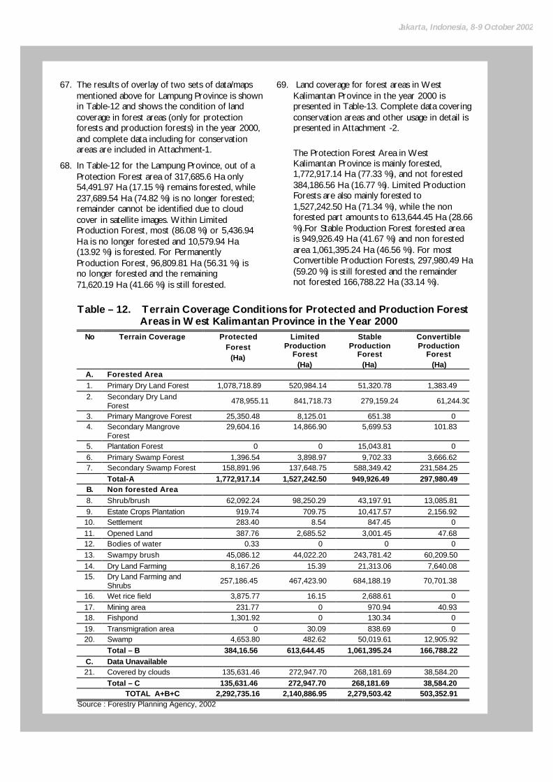
Jakarta, Indonesia, 8-9 October 2002
67. The results of overlay of two sets of data/maps mentioned above for Lampung Province is shown in Table-12 and shows the condition of land coverage in forest areas (only for protection forests and production forests) in the year 2000, and complete data including for conservation areas are included in Attachment-1.
68. In Table-12 for the Lampung Province, out of a Protection Forest area of 317,685.6 Ha only 54,491.97 Ha (17.15 %) remains forested, while 237,689.54 Ha (74.82 %) is no longer forested; remainder cannot be identified due to cloud cover in satellite images. Within Limited Production Forest, most (86.08 %) or 5,436.94 Ha is no longer forested and 10,579.94 Ha (13.92 %) is forested. For Permanently Production Forest, 96,809.81 Ha (56.31 %) is no longer forested and the remaining 71,620.19 Ha (41.66 %) is still forested.
69. Land coverage for forest areas in West Kalimantan Province in the year 2000 is presented in Table-13. Complete data covering conservation areas and other usage in detail is presented in Attachment -2.
The Protection Forest Area in West Kalimantan Province is mainly forested, 1,772,917.14 Ha (77.33 %), and not forested 384,186.56 Ha (16.77 %). Limited Production Forests are also mainly forested to 1,527,242.50 Ha (71.34 %), while the non forested part amounts to 613,644.45 Ha (28.66 %).For Stable Production Forest forested area is 949,926.49 Ha (41.67 %) and non forested area 1,061,395.24 Ha (46.56 %). For most Convertible Production Forests, 297,980.49 Ha (59.20 %) is still forested and the remainder not forested 166,788.22 Ha (33.14 %).
Table – 12. Terrain Coverage Conditions for Protected and Production Forest Areas in West Kalimantan Province in the Year 2000
No Terrain Coverage
Protected Forest
(Ha)
Limited Production
Forest (Ha)
Stable Production
Forest (Ha)
Convertible Production
Forest (Ha)
A. Forested Area 1. Primary Dry Land Forest 1,078,718.89 520,984.14 51,320.78 1,383.49 2. Secondary Dry Land
Forest 478,955.11 841,718.73 279,159.24 61,244.30
3. Primary Mangrove Forest 25,350.48 8,125.01 651.38 0 4. Secondary Mangrove
Forest 29,604.16 14,866.90 5,699.53 101.83
5. Plantation Forest 0 0 15,043.81 0 6. Primary Swamp Forest 1,396.54 3,898.97 9,702.33 3,666.62 7. Secondary Swamp Forest 158,891.96 137,648.75 588,349.42 231,584.25 Total-A 1,772,917.14 1,527,242.50 949,926.49 297,980.49
B. Non forested Area 8. Shrub/brush 62,092.24 98,250.29 43,197.91 13,085.81 9. Estate Crops Plantation 919.74 709.75 10,417.57 2,156.92 10. Settlement 283.40 8.54 847.45 0 11. Opened Land 387.76 2,685.52 3,001.45 47.68 12. Bodies of water 0.33 0 0 0 13. Swampy brush 45,086.12 44,022.20 243,781.42 60,209.50 14. Dry Land Farming 8,167.26 15.39 21,313.06 7,640.08 15. Dry Land Farming and
Shrubs 257,186.45 467,423.90 684,188.19 70,701.38
16. Wet rice field 3,875.77 16.15 2,688.61 0 17. Mining area 231.77 0 970.94 40.93 18. Fishpond 1,301.92 0 130.34 0 19. Transmigration area 0 30.09 838.69 0 20. Swamp 4,653.80 482.62 50,019.61 12,905.92
Total – B 384,16.56 613,644.45 1,061,395.24 166,788.22 C. Data Unavailable 21. Covered by clouds 135,631.46 272,947.70 268,181.69 38,584.20
Total – C 135,631.46 272,947.70 268,181.69 38,584.20 TOTAL A+B+C 2,292,735.16 2,140,886.95 2,279,503.42 503,352.91
Source : Forestry Planning Agency, 2002

24
RUPES Indonesia/National Level Inception Workshop
70. Land coverage data for forest areas in East Kalimantan Province in the year 2000 is presented in Table-13. Complete data covering conservation areas and other usage in detail is presented in Attachment -3.
All forest areas in East Kalimantan is mostly covered by natural forests. Of Protection Forests totaling 2,793,556.44 Ha, 2,343,287.96 Ha (83.88 %) remains forested, only 83,793.67 Ha (3 %) is not forested; Limited Production Forest amounts to 5,172,363.51 Ha of which 4,064,141.35 Ha (78.57 %) is forested and 372,054.57 Ha (7.19 %) is not forested; for Permanently Production Forest of 4,622,624.96 Ha, 58.08 % is still forested and 1,431,676.79 Ha (30.97 %) no longer.
Potential Forest Areas Worthy of Being Maintained 71. In connection with ideas of rationalization of
forest areas in Indonesia in accordance with the Terms of Reference of this study, required are identification criteria for (national) forest areas whose existence should be maintained under Government control (read: Central, Provincial, District and City government according to the regulations) in accordance with its capacity and responsibility as implementers of public policy. Below several criteria are brought forward for further consideration before being used as the basis for decisions.
Table – 13. Land Coverage Conditions for Protection and Production Forest Areas in East Kalimantan Province in the Year 2000
No Land Coverage
Protection Forest
(Ha)
Limited Production Forest(Ha)
Permanent Production Forest (Ha)
Convertible Production Forest(Ha)
A. Forested Area 1. Dry Primary Forest Terrain 1,851,746.36 2,218,459.31 363,477.74 0 2. Dry Secondary Forest Terrain 491,526.88
1,833,966.50
1,781,666.32 0
3. Primary Mangrove Forest 0 0 15,606.04 0 4. Secondary Mangrove Forest 0 0 161,470.32 0 5. Planted Forest 14.72 6,388.00 198,227.50 0 6. Primary Swamp Forest 0 0 82,869.55 0 7. Secondary Swamp Forest 0 5,327.54 81,535.06 0 Total-A 2,343,287.96 4,064,141.35 2,684,852.53 0
B. Non forested Area 8. Underbrush 43,865.26 306,905.70 831,508.76 0 9. Plantation 272.58 331.08 20,380.87 0 10. Settlement 58.49 455.03 2,709.87 0 11. Open Terrain 23,555.70 27,044.48 18,306.92 0 12. Bodies of water 0 0 0 0 13. Swampy underbrush 1,691.91 412.96 213,519.06 0 14. Dry Terrain Farming 0 1,370.01 6,186.83 0 15. Dry Terrain Farming + Shrubs 13,870.64 33,186.30 190,424.83 0 16. Wet rice field 0 0 0 0 17. Mining 76.25 771.63 2,410.02 0 18. Fishpond 0 0 30,755.68 0 19. Transmigration 0 0 4,231.45 0 20. Swamp 402.84 1,577.38 111,242.50 0
Total – B 83,793.67 372,054.57 1,431,676.79 0 C. Data Unavailable 21. Covered by clouds 366,474.81 736,167.59 506,095.64 0
Total – C 366,474.81 736,167.59 06,095.64 0 TOTAL A+B+C 2,793,556.44 5,172,363.51 4,622,624.96 0
Source : Forestry Planning Agency, 2002

Jakarta, Indonesia, 8-9 October 2002
Criteria-1: Function of forest area 10/ according to Govt. Regulation No. 47 of 1997 on National Spatial Plan and Govt. Reg. No. 68 of 1998 on Nature Reserve Area and Nature Preservation Area (already/not yet designated by the Forestry Minister);
Criteria-2: Legality of forest area (boundary demarcation already / not yet delineated at the regional level, and already / not yet gazetted by the Minister of Minister);
Criteria-3: Latest land coverage (forested/not forested);
Criteria-4: Protected area category based on Govt. Reg. No. 47 of 1997 on National Spatial Plan (included/not included);
Criteria-5: Suitability as a forest area based on technical criteria in Govt. Reg. No. 47 of 1997 on National Spatial Plan and Govt. Reg. No. 68 of 1998 on Nature Reserve Area and Nature Preservation Area as decided by the Government based on a integrated investigation according to article 19 paragraph 1 Law No. 41 of 1999 (feasible/not feasible);
Criteria-6: The existence of valid title and/or licenses to third parties issued by Central/Regional Government (yes/no)
72. From above description, the forest areas which should be maintained and then controlled by the Government (read: Central/ Provincial/ Regency/City Government) is when they meet these following points simultaneously:
a. Forest area with the forest function covering nature reserve forest, nature preservation, hunting park, protected forest and production forest as designated by a decision of the Minister of Forestry or at a provincial level that has not been designated should refer to the results of the synchronization TGHK and RTRWP
10/ This Government Regulation is used because implementers
regulations for Law No. 41 of 1999 on Forestry has not been published to date.
(Governor’s Decree) or RTRWP (Regional Regulation);
b. Such forest area’s boundary has been set in order by the regional government and an official report on the boundaries set has been made or has been appointed by Minister of Forestry;
c. Such forest area including the protected area category namely nature reserve area, nature preservation area, hunting parks, protection forest, peat areas, water absorption area, river demarcation, coastal demarcation, areas surrounding lakes/dams, areas surrounding springs, open city greenery (including city forest), cultural preservation areas, swampy areas, natural disaster areas (volcano eruption, earthquake, landslides, tidal waves and floods), biosphere preserve, germ plasma protection area, wildlife refugee area and area mangrove forest coast.
d. Such forest area condition still has forest land coverage and includes: primary dry land forest, secondary dry land forest, primary mangrove forest, secondary mangrove forest, plantation forest, primary swamp forest, secondary swamp forest;
e. Is such a forest area suitable according to the technical criteria set.
f. Is such a forest area still under concession/license to third parties as issued by Government (Central/Regional) in accordance with valid regulations and has not yet expired.
73. From the above mentioned criteria it appears that to know quantitatively the total forest area that should be maintained under Government control, complete quantitative data is required covering the 6 (six) criteria mentioned above. In this paper, the data for Lampung, West Kalimantan and East Kalimantan provinces consists of data showing forest areas and forest cover. Therefore quantitative data, due to the limited time of this study, can not yet be presented in this article except in the form of the relevant formulas.
74. To calculate how big the forest area that is worth conserving and managed by Government (Central/Regional) the following formula can be used:
(A + Ba1 + Bb1 + Bc1 +Bd1)

26
RUPES Indonesia/National Level Inception Workshop
in which: A = Area of conservation forest,
protection forest, and production forest that has been designated by the Minister of Forestry, and land coverage is forested.
Ba1 = Area of production forest designated by Minister of Forestry, and land coverage is non forested, and boundaries marked in the Region and or already gazetted by the Minister of Forestry.
Bb1 = Area of production forest designated by the Minister of Forestry, non forested, and includes protected areas as covered by Govt. Regulation No. 47 of 1997.
Bc1 = Area of production forest designated by the Minister of Forestry, non forested, and forest function is suitable with the criteria according to Govt. Reg. No. 47 of 1997 and Govt. Reg. No. 68 of 1998.
Bd1 = Area of production forest designated by the Minister of Forestry, non forested, and legal title/license has been issued to third parties by Government (Central/Regional)
75. For nature reserve forest area, nature preservation area, hunting parks and protection forest and production forest whose existence is maintained even though field conditions show them not forested, but Government (Central/Regional) is responsible for reforestation or rehabilitation of forest and land, to realize optimization of function and benefit of said forest. So it is not wise to only consider the land coverage as the only criteria to decide on allocation of state forest area over which control can be handed over to a community who has the right. This is to avoid the incidence of precedents that are not good that can be utilized by certain parties (free rider, rent seeker and opportunists) whose aim is to control / occupy forest area illegally by destroying the forest beforehand by illegal logging.
Potential Forest Areas Whose Management Can be Surrendered to the Community
76. By using criteria as described in paragraph 5.3. potential forest area can be formulated that can be considered for handling over to be managed by a community who have a legal right as laws and regulations, namely if meeting these following points simultaneously:
a Production forest areas as designated by the Minister of Forestry or for a province having none, they can refer to the synchronization of TGHK and RTRWP (Governor’s Decree) or RTRWP (Regional Regulation);
b. Regional Government has not marked boundaries for said forest area and therefore the Minister of Forestry has not gazetted it;
c. Such forest area does not include protected area category as set in Govt. Reg. No. 47 of 1997 on National Spatial Plan;
d. Said forest area’s land cover is not forested and consists of : shrub/brush, estate crops plantations, settlements, opened land, bodies of water, swampy brush, dry land farming, dry land farming mixed with brush, wet rice fields, mining, fishponds, transmigration, and swamps;
e. Such forest area after review by Government based on joint investigation in accordance with the stipulations of article 19 paragraph 1 of Law No. 41 of 1999, is not feasible according to technical criteria in Govt. Reg. No. 47 of 1997;
f. Such forest area is not covered by legal title/licenses to third parties from Government (Central/Regional).
77. In the form of a formula, it can be expressed as:.
(Ba2 + Bb2 + Bc2 + Bd2)

Jakarta, Indonesia, 8-9 October 2002
in which:
Ba2 = Area of production forest has been designated by the Minister of Forestry, non forested, and boundaries have not been mark at the regional level and not gazetted by the Minister of Forestry.
Bb2 = Area of production forest designated by the Minister of Forestry, non forested, and does not includes protected areas as covered by Govt. Regulation No. 47 of 1997.
Bc2 = Area of production forest designated by the Ministry of Forestry, non forested, and forest function is not in accordance with the technical criteria of Govt. Reg. No. 47 of 1997 and Govt. Reg. No. 68 of 1998.
Bd2 = Area of production forest designated by the Minister of Forestry, non forested, and no legal title/license has been issued to third parties by Government (Central/Regional)
JUSTIFICAT ION OF IMPLEMENTION SCENARIO AND POLICY REFORM
Implementation Scenario for Rationalization of Forest Areas 78. Based on criteria described in paragraph 5.3
above there are 3 (three) implemention scenario for rationalization of forest areas in Indonesia and its policy implication and follow up steps. These are:.
§ Scenario- I (Status Quo) : No rationalization of forest areas
§ Scenario- II (Moderate) : Give to the community utilization / usage rights to forest area
§ Scenario III- (Extreme) : Give to community title to forest area terrain.
79. These three scenarios are shown in Table-14 and meant to provide options for Government policy as material for consideration in making a decision.

28
RUPES Indonesia/National Level Inception Workshop
No.
Implementation of Forest Area Rationalization Scenario Policy Implication
Follow up Steps
1 2 3 4 1. 2.
3.
Scenario – I (Status Quo) No rationalization of forest areas. Scenario-II (Moderate) Give to the community right of utilization / usage of forest area that has been appointed by the Forestry Minister but boundaries not yet set by Regional Govt. / not confirmed by Forestry Minister, is not in a protected area, terrain coverage not forested, according to technical criteria physically unsuitable as forest area, no legal title/license to utilize forest area, with following stipulations: a/.To the legal title/license holders in such forest area whose title/license has not expired is given the choice:
- Voluntarily returning such title/license to such forest area to Government without compensation, but this will not mean “pardon” for responsibility or obligation of such title/license holders; -Continue such title/license until end of validity (not extended) but during such period obliged to form a partnership with the community that has received title to the forest area terrain and after title/license expires terrain is handed over to the relevant community b/.The traditional law community / traditional title or who feel they hold title to such forest terrain is handled in this manner.: -if such title has been issued by a Regional Regulation, such forest land becomes his domain -if such title has not yet been affirmed by a Regional Regulation a claim should be addressed to the Government with sufficient proof of title, but with no guarantees.
Scenario III (Extreme) Give the community title of land in the forest area described in Scenario II under the same stipulations
q Field problems with claims in matters of terrain under control in state forest areas is expected to increase and more difficult to solve.
q Legal certainty of state forest areas is only in law (de jure) not in fact (de facto), because in reality such terrain is controlled by the community so it is considered not legitimate by the community
q Rate of deforestation and degradation of natural forests will increase in future.
q Forest resources do bring optimum environmental, social and economic benefits to community.
q In this regional autonomy era, does not bring enlightenment harmony in perception and policy of Central and Provincial / Regency / City Government in handling and managing of forest areas and in perpetuity based on justice and the people’s welfare.
q Significantly reduce claims of l land tenure
in forest area. q Directly involving community will
significantly increase sense of belonging and sense of responsibility in managing forest in perpetuity within environment.
q Damage to natural forests due to illegal logging and pillaging of forests can be minimized.
q Improve sense of social justice by opening business opportunities, employment opportunities, and income for the community (target group).
q Improve terrain productivity in non forested forest areas that means improving efficiency of managing forest resources.
q Providing incentives for real and responsible regional autonomy in forestry.
q Will lead to larger implications than
Scenario II because the impact of certainty of community title to forest area, namely ownership title
q But negative implications might arise that is the increase of land fragmentation, because it is easier to sell [parts of] land and difficult to control.
According to present policy q Role of Related Authorities Identify and administer target group, strengthen local community institutions and technical aid for land utilization in a planned and united way, according to duty and function of related Provincial / Regency / City / Governmental agencies / institutions and the agencies for Forestry, Land, Agricultural, Plantation, livestock, marine / fishery, Kimpraswil, Transmigration, Manpower, Co-operative, Banking, etc.
q Cost Estimates Should be identified in more detail according to stage of development of the transfer of terrain control over forest areas to community. q Procedural Time Frame -Target group identification -Identification of source forest land to be re-allocated -Administrative process stage -Enhancement of institutions and technical aid stage q Institutional Requests Political support from provincial / regency / city Government is very vital to accomplish this. q Follow up steps
approximately the same as for Scenario II above.
q To speed up distribution process of title to terrain pro-active steps will be needed such as a terrain adjudication program.
Table – 14. Scenario for Implementation of Forest Area Rationalization

Jakarta, Indonesia, 8-9 October 2002
Solidification of Forest Areas: Current Policy, Conditions and Problems, Policy Reform and Implication
80. One policy of the Forestry Department closely related to the issue of rationalization of forest areas in Indonesia is the solidification of forest areas. According to Law No. 41 of 1999 on Forestry, solidification of forest areas is a forest area gazettment activity implemented through the processes of designating, boundary marking, mapping and legalizing of forest area.
81. Means for Solidification of Forest Area is completely set out in Minister of Forestry Decree No. 399/Kpts-II/1990 and No.634/Kpts-II/1996 on Guidelines for
Solidification of Forest Areas and No.400/Kpts-II/1990 and No. 635/Kpts-II/1996 on Forest Area Boundary Marking Committee and No.613/kpts-II/1997 on Solidification of Nature Reserve Area and Preservation of Ocean Nature Conservation, and finally regulated by Minister of Forestry Decree No. 32/Kpts-II/2001 on Criteria and Standard for Solidification of Forest Areas as a follow up to Govt. Regulation No. 25 of 2000. This is processed in The Draft of Government Regulation on Forestry Planning as follow up to Law No.41 of 1999.
82. In the framework of anticipating future policy related to the issue of rationalization of forest areas, Tabel-15 describes current policy, problems faced, and suggested policy reform in solidification of forest areas and the required follow up steps.
Table – 15. Solidification of Forest Areas and Policy Reform No Current Policy Constrains/
Problems Policy Reform Follow up steps
1.
A. 2.
B. 3.
4.
5.
6.
7.
Legal basis is: Minister of Forestry Decree No. 32/Kpts-II/2001 on Criteria and Standard for Solidification of Forest Areas (as follow up to PP No. 25 of 2000) Forest Area Designation Criteria should include: not covered by land title and forested / not forested. Forest Boundary Marking Criteria should be free from title held by third parties Committee for forest boundaries demarcation consists of representatives from regency / city, sub-district head, village chief, community leaders The participatory approach in determining border lines, decision on boundaries and official report on boundary demarcation. Targets for boundary re-ordering not yet specified in terms of length of border (Km) or size of forest area (Ha) Approach used to achieve target for forest area boundary demarcation is the achievement of: physical certainty in the field, legality of official report, and admission of legitimateness by community
Many provincial / regency / city governments have not yet followed up by preparing manuals, technical implementation guidelines. Often overlapping with title of traditional law community / traditional title or terrain used by community Often claimed by traditional law community / traditional title and users of community land Experience has shown that community leaders residing near border lines have often not been included In implementation often not participatory. If length of border is specified, size of forest area difficult to achieve. In reality it is difficult to realize all three at the same time.
Public consultation and dialogue with Central, provincial, regency/ city, Government and DPR / DPRD and institutions / groups / local community leaders to receive their aspirations Area which designated as forest area: does not embrace traditional law community land / traditional title or terrain used by the community Area which boundary marking should be free from traditional community land / traditional title or terrain used by the community Clarify by involving a minimal of 3-5 community leaders living near border lines. To ensure real participation local community should be given a more dominant role in border delineation, border decisions and official report on boundary re -ordering In era of regional autonomy it is important to set targets of boundary re-ordering in terms of by regency/city on a area unit basis (Ha), and not in length of border (Km) Admission of community living around forest is very vital, should be realized and entered in an Official Report on Community Acknowled-gement so that they feel that they own and are responsible for the forest area
q Role of related agencies
Forestry Department, Provincial / Regency / City Government, Forestry Agency UPT Forestry Dep., BPN / National Land Registration Office etc. should be coordinated, integrated, synchronized so it there is synergy in implementing suggested policy reforms q Cost Estimates Calculate funds required among others for addition of new members to border demarcation committee. q Procedural Time Concrete action plan to be formulated particularly to speed up boundary demarcation process and gazetting on forest area. q Institutional Requests Regency / City Government should support forest area boundary demarcation process in a more participating transparent and accountable way

30
RUPES Indonesia/National Level Inception Workshop
Change of Status and Function of Forest Area: Current Policy, Condition and Problems, Policy Reform and Implication
83. Other policies closely related to the issue of the rationalization of forest areas in Indonesia is the change in status and function of forest areas as last arranged in Forestry Minister Decision No. 70/Kpts-II/2001 on Assigning of
Forest Areas, Change in Status and Function of Forest Areas. By change in status of forest areas is to change the status of part of a forest area to a non-forest area. Change in function of a forest area is to change part or the entire forest function for a given forest area.
84. Description of present day policy, problems, reforms and policy implications and change in status and change in function for forest areas is described in Table-16.
Table – 16. Forest Area Status and Function Change and Policy Reform No Present Policy Constrains/
Problems Policy Reform Follow up steps
1.
A.
2.
3.
B.
4.
Legal basis is: Minister of Forestry Decree No. 70/Kpts-II/2001 on Determination of Forest Areas and Status and Function Change of Forest Areas (as follow up to PP No. 25 of 2000) Status Change of Forest Land Forest areas that can be changed in status are Convertible Production Forests (HPK). Change of status for Production Forests can be made if: -for strategic purposes -does not destroy the environment -does not form an enclave -field score less than 125 -does not decrease 30% minimum forest area of DAS (river basin) area -approved by District/City and or Provincial DPRD -if it has an important impact , of wide scope and has strategic value it should be approved by the DPR etc. Change of forest area status is by : -release if HPK -exchange of forest areas Change of Forest Land Function Can only be made if convertible forest area whose function will be changed meets criteria and standards for forest function decisions.
Provincial / district / city Government not fully taking follow up steps in the field, and several regencies have even made their own rules -In some provinces there are no longer any HPK; Due to RI–CGI commitment, moratorium on natural forest conversion until National Forest Program formed Function of forest area that are set during appointment by provincial authority generally do not include detailed scoring by forest groups.
Public consultations and dialogues with officials from Central, provincial, district / city Government, DPR / DPRD, and local institutions / groups / local community leaders to receive their aspirations. Added to paragraph 5.3 and 5.4., where the criteria for forest area changes are: -for production forest -not forested, -boundaries not yet demarcated by the MOF. -not a protected area -based on combined investigation, does not meet technical criteria -not covered by third party title/license Integrated into the review process mechanism for RTRWP held minimum once every 5 years Change in forest area function requires application of space technical criteria as by Govt. Regulation No. 47 of 1997, performed by a Combined Team in an objective, independent and scientific way
q Role of related agencies Forestry Department, Provincial/District/City Government, Forestry, UPT Forestry Dep., BPN, Office of the State Minister for LH, LIPI agencies etc. requires coordination, integration, synchronization and synergy in implementing the suggested policy reforms . q Costs Estimates Costs estimates should be calculated in accordance with the required scope of activities. q Procedural time Periodical rescheduling covering planning, implementation and control by province by Central Government cq. MOF. q Institutional Requests Provincial / District / City Government has to support this process, but it is important to avoid efforts by certain parties with vested interests.

BIBLIOGRAPHY
Costa, P.M. et.al (1999). Programme on Forests. Working Draft. Financial Mechanisms for Sustainable Forestry. Bureau for Development Policy.UNDP. New York. Kusumaatmadja, S (1995). Global Biodiversity Management Policy and it Implication on the National Scale. Second Seminar on Socialization of the Second Meeting of the UN Convention on COP II CBD. Jakarta. Santoso, Harry (2000). Moratorium of Conversion of Natural Forests, Government Perspective. Seminar on Moratorium of Conversion of Natural Forests and Closing Down of Forest grown Wood Fiber Industry. Jakarta. --------------------- (2001). Recalculation of Production Forest Areas, Protected Forest and Conservation Area. Central Forestry Mapping, Forestry Planing Board. Jakarta. --------------------- (1997). Indonesia Forestry Action Program. Country Brief. Ministry of Forestry. Jakarta. --------------------- (1996). Final Report on Statistics of Indonesia Forest Resources (Excluding Java). Volume I. General Directorate of Inventory and Uses of Forests, Forestry Department. Jakarta. --------------------- (1992). Indonesia Forestry Statistics 1990/1991. Planning Bureau General Secretariat
Forestry Department. Jakarta.