Embed Size (px)
Citation preview
RD
Yelbeni
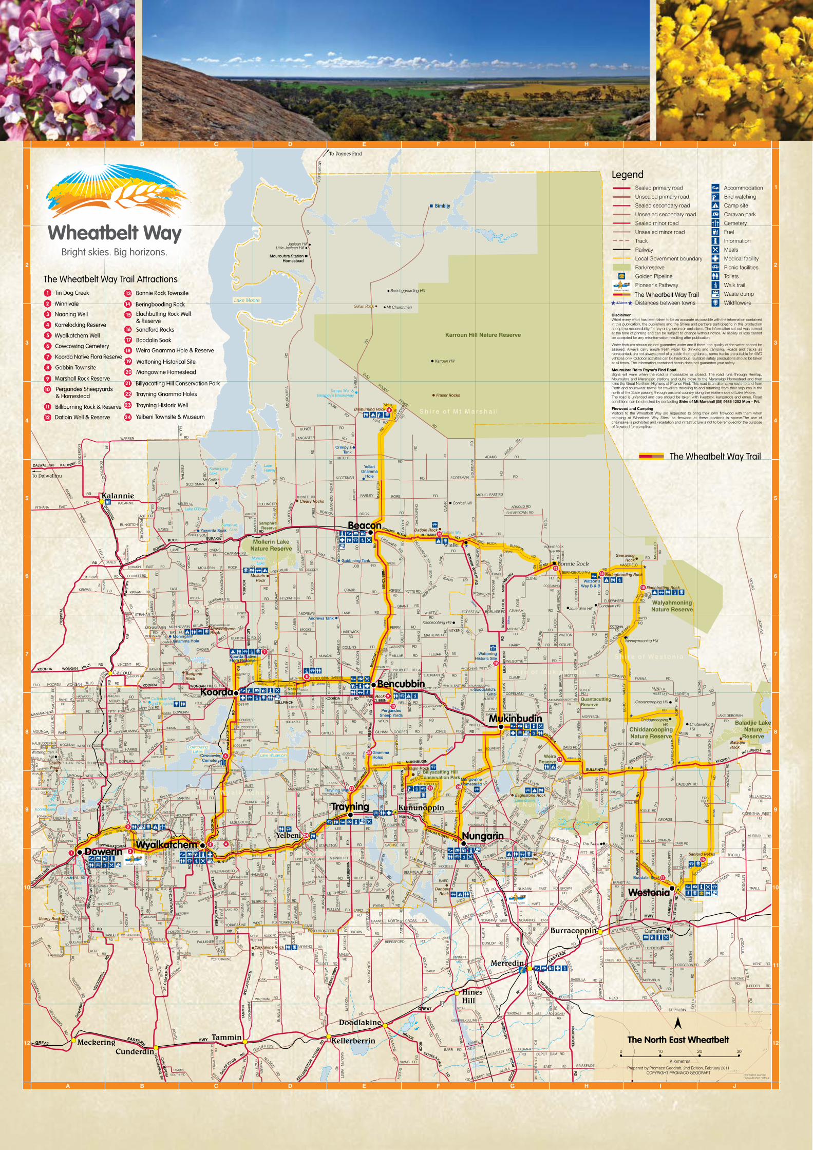
Legend
The Wheatbelt Way Trail
The Wheatbelt Way Trail
The Wheatbelt Way Trail Attractions
The North East Wheatbelt
DisclaimerWhilst every effort has been taken to be as accurate as possible with the information contained in this publication, the publishers and the Shires and partners participating in this production accept no responsibility for any entry, errors or omissions. The information set out was correct at the time of printing and can be subject to change without notice. All liability or loss cannot be accepted for any misinformation resulting after publication.
Water features shown do not guarantee water and if there, the quality of the water cannot be assured. Always carry ample fresh water for drinking and camping. Roads and tracks as represented, are not always proof of a public thoroughfare as some tracks are suitable for 4WD vehicles only. Outdoor activities can be harardous. Suitable safety precautions should be taken at all times. The information contained herein does not guarantee your safety.
Mouroubra Rd to Payne's Find RoadSigns will warn when the road is impassable or closed. The road runs through Remlap, Mouroubra and Maranalgo stations and quite close to the Maranalgo Homestead and then joins the Great Northern Highway at Paynes Find. This road is an alternative route to and from Perth and southwest towns for travellers travelling to and returning from their sojourns in the north of the State passing through pastoral country along the eastern side of Lake Moore. The road is unfenced and care should be taken with livestock, kangaroos and emus. Road conditions can be checked by contacting Shire of Mt Marshall (08) 9685 1202 Mon – Fri.
Firewood and CampingVisitors to the Wheatbelt Way are requested to bring their own firewood with them when camping at Wheatbelt Way Sites, as firewood at these locations is sparse.The use of chainsaws is prohibited and vegetation and infrastructure is not to be removed for the purpose of firewood for campfires.
Nungarin
Beacon
KoordaBencubbin
Westonia
Mukinbudin
Trayning
1 3
2
45
6
7
8
9
10
11
12
1314
15
16
17
18
19
2021
22
23
24
Tin Dog Creek
Minnivale
Naaning Well
Korrelocking Reserve
Wyalkatchem WellSandford Rocks
Boodalin SoakCowcowing Cemetery
Koorda Native Flora Reserve
Gabbin Townsite
Marshall Rock Reserve
Pergandes Sheepyards & Homestead
Billiburning Rock & Reserve
Datjoin Well & Reserve
Bonnie Rock Townsite
Beringbooding Rock
Weira Gnamma Hole & Reserve
Billyacatting Hill Conservation Park
Trayning Gnamma Holes
Trayning Historic Well
Yelbeni Townsite & Museum
Elachbutting Rock Well & Reserve
Wattoning Historical Site
Mangowine Homestead
13
14
15
16
17
18
19
20
21
22
23
24
1
2
3
4
5
6
7
8
9
10
11
12
Wyalkatchem ●

D R I V E T R A I L
Dowerin Wyalkatchem
Koorda Bencubbin
Beacon Westonia
Mukinbudin Nungarin Trayning
Western Australia
Further Information:
Get a copy of the FREE 50 page Wheatbelt Way Self Drive Trail Guide Book, with detailed information on each of the nine towns and sections on each of
the 24 interpreted sites as well as two Audio CDs with dramatised stories to guide you on your journey
through the north eastern wheatbelt.
Request a copy of the guidebook and map to be posted to you or download from www.wheatbeltway.com.au
DowerinLocated 160 kilometres, or 2 hours northeast of Perth. The Shire’s 760 residents enjoy a temperate climate with winter rainfall and hot, dry summers. The appealing country environment is complemented by a vibrant community lifestyle as well as the development of state of the art new facilities, such as the Dowerin Community Club Recreation facility. Dowerin offers a range of attractions to suit every member of the family. Why not stay a night or two in Dowerin to give you plenty of time to explore the area. Start the day with a visit to the Dowerin Bakery to pack a hearty lunch and some delicious sweet treats and spend the rest of the day visiting ‘Rusty’ and the Tin Dog Creek Walking Trail and Bird Hyde, Namelkatchem Reserve and Well, Daren Lakes and Naaning Well. Whether you’re an experienced bushwalker or simply out for a stroll, the Reserves and walk trails surrounding Dowerin give an insight into the rich history of the region and exhibit some spectacular orchids and wildflowers.
Wyalkatchem“Welcome to Wylie”, you’ll hear the locals’ say. The friendly country spirit is alive and well here at this “Strange name, beaut’ place”. The first recorded exploration of the district in 1846 was made possible with the assistance of Aboriginal information and guidance into the area. The first settlers took up land in 1904, and the town-site was officially declared during 1908. Wyalkatchem’s main economy has been historically based on grain production and sheep farming, and while this is still a major industry, we are now embracing tourism and developing services to encourage visitation to our wonderful countryside. Wyalkatchem is known as the “Cradle of Bulk Handling” in Western Australia because it is here that the first ever delivery of bulk wheat was received for market at Korrelocking on November 9, 1931. Anyone interested in having an experience to “step back in time” will love the CBH Museum and Old School House where you can trace the history of the pioneering community. Nature lovers are well catered for, with the Walk-A-Wyal tracks, Cowcowing Lake, and Yorkrakine Rock being great destinations where you can enjoy unique flora and fauna in the peaceful surroundings of some of the oldest reserve areas in WA. Not to be missed is a visit to the historic Wyalkatchem Well, a picnic at Korrelocking Reserve, and an evening being awed and inspired viewing some of the best starlit skies in the world.
BencubbinAlong with Beacon, Bencubbin is one of the two main centres servicing the Shire of Mt Marshall. The town’s name is derived from “Gnylbencubbing” the Aboriginal name for nearby Marshall Rock. Bencubbin is located at the southern end of the Mt Marshall Shire, stop and check out the Sandalwood dray and interpretive centre, climb up Marshall Rock which offers superb 360 degree views of the surrounding farming land, Lake McDermott, Bencubbin town, Welbungin and Wiacubbing Hill. Take a trip back in time and be amazed at Pergande’s Sheep Yards, which were constructed almost entirely from granite from nearby rock. Those visiting the area between July and October will be in for a treat as the abundant wildflowers will be in full bloom following the winter rains.
NungarinOne of the smallest shires in the country with just 240 people, but what we lack in size we make up for in just about everything else. Nungarin is located 300 kilometres east of Perth. Nungarin has a rich and varied history, including serving as an important stopping place during the 1880’s Eastern Goldfields rush. It also served as an important WWII strategic army depot and workshop with almost 12,000 troops stationed in the town at one stage. Nungarin is now a progressive and community focused shire, boasting an appealing lifestyle for residents. No trip to Nungarin should occur without a visit to the extensive Heritage Machinery and Army Museum. Items are housed in an enormous 2,500 square metre, timber clad building and map Australia’s rich pioneering and army history. Historic Mangowine homestead is unique in depicting an era of life gone by in the region. For those wanting to get out and explore the area, visits to Danberrin Hill, Eaglestone Rock and Talgomine Reserve are highly recommended. They offer stunning views, and an opportunity to explore the vast Wheatbelt landscape. Before you leave the town, make sure to pick up a souvenir at the charming Nungarin Wheatbelt Markets held on the first Sunday of the month March through to December.
ACCOMMODATION
DOWERIN CARAVAN PARK AND MOTEL TEL: 08 9631 1135
DOWERIN COMMERCIAL HOTEL TEL: 08 9631 1206
CAMPING AND SULLAGE FACILITIES AVAILABLE AT MINNIVALE
TOURIST INFORMATION
DOWERIN COMMUNITY RESOURCE CENTRE STEWART STREET, DOWERIN
TEL: 08 9631 1662
SHIRE OF DOWERIN 13 COTTRELL STREET, DOWERIN TEL: 08 9631 1202
ACCOMMODATION
WYALKATCHEM TRAVELLERS PARK TEL:0427 814 042
WYALKATCHEM HOTEL TEL: 08 9681 1210
WYALKATCHEM BARRACKS (BACKPACKERS OR GROUPS)
TEL: 08 9681 1166
WYLIE STAYS TEL: 0413 004 414
WYLIE WEEKENDER TEL: 0439 036 551
TOURIST INFORMATION
WYALKATCHEM VISITOR CENTRE, THE BUSHEL, RAILWAY TERRACE, WYALKATCHEM
TEL: 08 9681 1500
MukinbudinThe Shire of Mukinbudin was settled by pastoralists who in the 1870’s took up large leases in excess of 20,000 acres to run sheep, as well as by Sandalwood cutters and miners en-route to the goldfields. Mukinbudin is a place for those who have an interest in the outdoors. There are no better places to experience this than Beringbooding Rock and Weira Reserve. Four wheel driving, BBQ’s, camping, bushwalking and spectacular views can be experienced amongst these attractions. Native flora lovers will enjoy the botanical walk and anyone with a passing interest in the history of the area should visit the unique bulk grain storage silo, the Mens Shed, Goodchilds Gateway and the Wattoning Historical Site.
ACCOMMODATION
MUKINBUDIN CARAVAN PARK AND SELF CONTAINED CHALETS
TEL: 08 9047 1103
MUKINBUDIN HOTEL TEL: 08 9047 1133
WATSON’S WAY B&B TEL: 08 9047 0008
ROSE COTTAGE COUNTRY RETREAT SELF CONTAINED ACCOMMODATION
TEL: 0418 912 125
CAMPING BERINGBOODING ROCK & WEIRA RESERVE
TOURIST INFORMATION
MUKINBUDIN COMMUNITY RESOURCE CENTRE, 8 WHITE STREET, MUKINBUDIN
TEL: 08 9047 2150
SHIRE OF MUKINBUDIN, 15 MADDOCK STREET, MUKINBUDIN
TEL: 08 9047 2100
TrayningThe Shire has 430 people in and around the townsites of Trayning, Kununoppin and Yelbeni and has a focus on agriculture. The area is named after Trayning Well, the Aboriginal name of a nearby water source located on the old road from Goomalling to the Eastern Goldfields. It was first recorded by a surveyor in 1892 and allegedly derives from the Aboriginal word ”durri-iring”, meaning “snake in the grass by the campfire”.
Visitors to Trayning will be treated to the beautiful natural surroundings of the region and are recommended to visit Billyacatting Hill, Yarragin Rock and the Gnamma Holes. A variety of amazing flora and fauna can be found at these locations and highlight the natural diversity of the area. Pack a picnic and enjoy the visitor facilities provided.
The Yelbeni Town Site Museum is relatively new, having been developed in 2002. It houses a very interesting collection of local history ranging from photos, plaques and pieces of vintage farm machinery that provide an accurate and informative glimpse of the past.
ACCOMMODATION
BENCUBBIN CARAVAN PARK (CABINS AVAILABLE)
TEL: 08 9685 1202
CAMPING MARSHALL ROCK
TOURIST INFORMATION
BENCUBBIN COMMUNITY RESOURCE CENTRE, MONGER STREET, BENCUBBIN
TEL: 08 9685 1007
BeaconThe town of Beacon is a vibrant and well established town boasting a range of facilities and services. The district was established in the 1920’s as a farming area and expanded following the construction of the railway line in 1931. Call at the Visitor Centre and view the 600 species herbarium display. Stroll through the Botanical Park off Broadbent Street and see the fabulous Sandpaper wattle before enjoying a cuppa while admiring the restored tractors at the Men’s Shed. Numerous Reserves and granite outcrops dot the landscape, the major one being Billiburning Rock, a popular a camping and picnic spot. Enjoy a glass of wine atop the rock as you watch the sun set and the stars come out. Perfect!
ACCOMMODATION
BEACON CARAVAN PARK & RAILWAY BARRACKS (CABINS AVAILABLE)
TEL: 0488 025 853
CAMPING BILLIBURNING RESERVE
TOURIST INFORMATION
BEACON CENTRAL COMMUNITY RESOURCE CENTRE, 11 ROWLANDS STREET, BEACON
TEL: 08 9686 1014
ACCOMMODATION
NUNGARIN CARAVAN PARK TEL: 08 9046 5006
MCCORRY’S OLD HOTEL (B&B AND POWERED CAMPING SITES)
TEL: 08 9046 5006
THE WOOLSHED HOTEL TEL: 08 9046 5084
MANGOWINE HOMESTEAD TEL: 08 9046 5149
CAMPING DANBERRIN HILL, EAGLESTONE ROCK, TALGOMINE RESERVEAND MANGOWINE HOMESTEAD
TOURIST INFORMATION
NUNGARIN COMMUNITY RESOURCE CENTRE, RAILWAY AVE, NUNGARIN
TEL: 08 9046 5400
KoordaIn 1917 the Koorda township sprang up around the railway worker’s camp and saw the establishment of a general store, post office, blacksmith, greengrocer and hostel to accommodate the seasonal worker, mainly baggers of wheat. Koorda continues its tradition of productive grain cultivation with sheep to a lesser degree than in the past. Koorda Museum is well worth a visit and, as it was formerly the town’s hospital, houses an interesting collection of antique medical and surgical equipment. The Koorda Motor Museum is also a place of interest with an extensive display of motor memorabilia and military collection. The Koorda Community Resource Centre also houses a wildflower interpretation display of the regions wildflowers. Koorda Drive-In has gained a broad following of patrons due to the installation of digital equipment screening of newly released movies is now possible. Please check our website www.koorda.wa.gov.au for details of screening dates. A visit to town would not be complete without exploring Mollerin and Newcarlbeon Rocks or a wander through the Koorda Native Flora Reserve. Anybody who enjoys the outdoors will be impressed by the picturesque formations, each with their own peculiar mini-environment of wildflowers and small animals.
Breathe the fresh air as you explore the history and natural beauty of the Wheatbelt Way. Picture yourself surrounded by a vast timeless land of bright skies and big horizons, rich with the sights and sounds
of nature, warm sunny days and cool evening breezes and green leafy trees contrasting with rugged rocky outcrops. Let us introduce you to the
unique charm of the Wheatbelt Way where you can experience good old-fashioned hospitality while exploring at your leisure. Whether you are
planning a short visit or longer stay, there is lots to see and do.
ACCOMMODATION
TRAYNING CARAVAN PARK TEL: 0428 997 156
TRAYNING HOTEL/MOTEL TEL: 08 9683 1005
TOURIST INFORMATION
SHIRE OF TRAYNING, RAILWAY STREET, TRAYNING TEL: 08 9683 1001
www.wheatbeltway.com.au
Drive Trail
NORTH EASTERN WHEATBELT
DRIVE TRAIL
Dowerin • Koorda • Beacon • Westonia • Nungarin
Wyalkatchem • Bencubbin • Mukinbudin • Trayning
ACCOMMODATION
KOORDA CARAVAN PARK TEL: 08 9684 1219
KOORDA HOTEL TEL: 08 9684 1226
YALAMBEE UNITS (SELF CONTAINED) TEL: 08 9684 1219
KOORDA FARM TREES ACCOMMODATION TEL: 0428 694 043
CAMPING MOLLERIN ROCK, NEWCARLBEON ROCK, KOORDA NATIVE FLORA RESERVE
TOURIST INFORMATION
KOORDA COMMUNITY RESOURCE CENTRE, 41 RAILWAY STREET, KOORDA
TEL: 08 9684 1081
SHIRE OF KOORDA, CNR HAIG & ALLENBY STREETS, KOORDA
TEL: 08 9684 1219
The Wheatbelt WayThe Wheatbelt Way self-drive trail will lead visitors on an adventurous interpreted journey to the regions communities of Dowerin, Wyalkatchem, Koorda, Bencubbin, Beacon, Westonia, Mukinbudin, Nungarin and Trayning, their natural attractions and history and heritage while offering them opportunities to stay and experience the unique Wheatbelt communities and landscapes.
Cov
er p
hoto
cou
rtes
y D
avid
Dun
cans
on
ta
ngel
ocre
ativ
e/W
BW61
34/3
0Sep
t201
6
N O R T H E A S T W H E A T B E L T
Westonia
The most striking thing about Westonia is its unique charm and natural surroundings, nestled amongst 5,600ha of salmon gum, morrell and gimlet woodland interspersed with granite outcrops and remnants of the town’s gold mining history. Stroll down the main street of Westonia and enjoy historic buildings, as well as new buildings that have also been built in a historic style. Call into the Hood-Penn Museum on the main street and notice the facades from the town’s original bank, café, hotel, fire station, boarding house and green grocer store fronting new buildings as you walk. Other wise head out for a picnic at Sandford Rocks or camp the night at Elachbutting Rock, while there take a walk through Monty’s Pass, stamp your foot in Kings Cave and photograph the colourful Rainbow Wave.
ACCOMMODATION
WESTONIA CARAVAN PARK TEL: 08 9046 7063
WESTONIA TAVERN TEL: 08 9046 7012
CARRABIN ROADHOUSE MOTEL & CARAVAN PARK TEL: 08 9046 7162
CAMPING ELACHBUTTING ROCK, ST LUKE’S CHURCH 48HR FREE CAMP
TOURIST INFORMATION
WESTONIA COMMUNITY RESOURCE CENTRE, WOLFRAM STREET, WESTONIA
TEL: 08 9046 7077
WESTONIA SHIRE OFFICE, WOLFRAM ST, WESTONIA TEL: 08 9046 7063