Embed Size (px)
Citation preview

Floodplain Modeling and Mapping Using
The Geographical Information Systems (GIS)
and
Hec-RAS/Hec-GeoRAS Applications.
Case of Edirne, Turkey.
Fuad Hajibayov*1
, Basak Demires Ozkul1, Fatih Terzi
1
1Istanbul Technical University, Department of Urban and Regional Planning
March 30, 2017
Summary The present study aims to produce flood inundation maps of different recurrent periods of the Meric
(Maritza) and Tundja (Tundzha) rivers in the area of Edirne city, Turkey. The case study area situates in
the intersection point of the Meric, Tundja and Arda rivers, which are at the same time transboundary
water channels that run through the territories of three countries; Turkey, Bulgaria and Greece. Edirne city
and its vicinities have been historically affected by natural flash floods which had negative impacts on
socio-economic dimensions of the settlement as well as on agricultural areas. The current study aims for
combined application of Geographical Information Systems (GIS) and hydraulic modeling in order to
determine flood extents as well as to analyze role of existing levee system. For this purpose, ArcMap
(ArcGIS) software of Environmental Systems Research Institute (ESRI) is set to be used for main
operations with the geographical data of the case study area, such as area topography. The necessity of
ArcMap is especially high, when developing the geometry of the area for further 1D steady flow
simulation. For this purpose, HEC-GeoRAS for ArcMap extension is used, whereas the major hydraulic
modeling and calculations are set to be done in river analysis system software HEC-RAS, which is the
product of US Army Corps of Engineers. Besides 1D steady flow, the study also develops 2D unsteady
flow analysis, based on the 2D mesh.
KEYWORDS: Edirne, Floods, Floodplain, GIS, HEC-RAS.
______________________ *1
1. Introduction
Turkey is one of the countries where natural disasters had a great negative impact on social and economic
dimensions throughout history. Thus, floods are considered to possess significant threat along with
earthquakes that occur in the country. Current study concentrates on Edirne city which is located in Thrace
region, the northwestern part of Turkey. Historically, the city and its neighborhood areas have been
affected by floods that occur due to the water overflow in the Meric and Tundja rivers. The Meric river
flows into Turkey from Bulgaria and continues to flow along the Turkish border with Greece until it
finally reaches the Aegean sea. Tundja river also flows from Bulgaria to Turkey, where it unites with the
Meric river in the area close to the center of Edirne city. The Arda river enters the Turkish territory from
the Greek side and flows approximately 1km., until it units with the Meric.
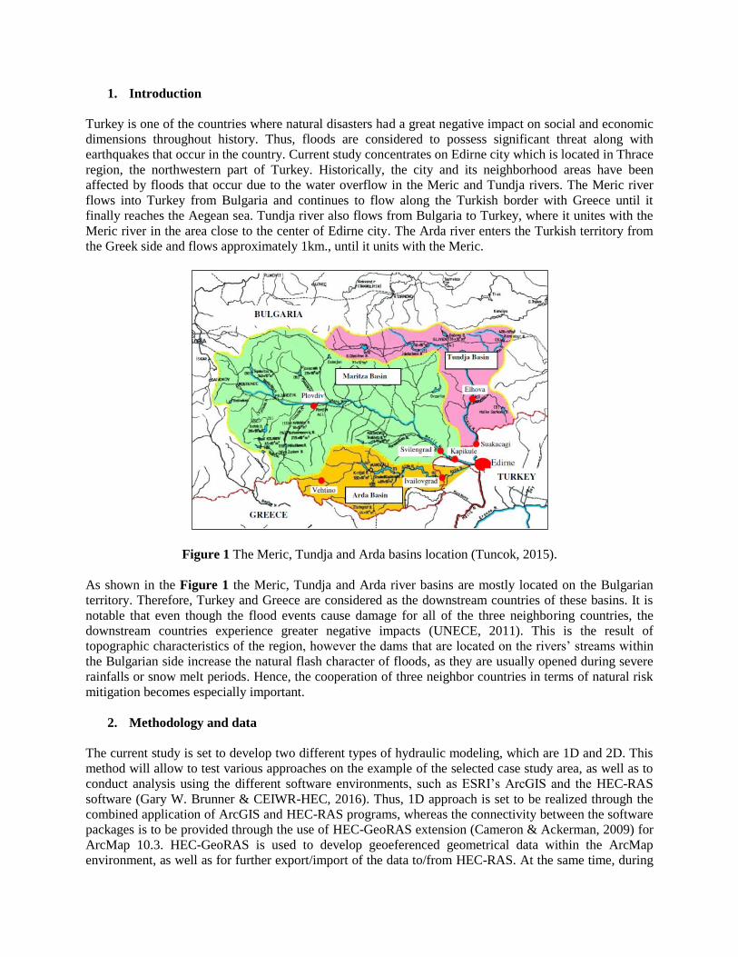
Figure 1 The Meric, Tundja and Arda basins location (Tuncok, 2015).
As shown in the Figure 1 the Meric, Tundja and Arda river basins are mostly located on the Bulgarian
territory. Therefore, Turkey and Greece are considered as the downstream countries of these basins. It is
notable that even though the flood events cause damage for all of the three neighboring countries, the
downstream countries experience greater negative impacts (UNECE, 2011). This is the result of
topographic characteristics of the region, however the dams that are located on the rivers’ streams within
the Bulgarian side increase the natural flash character of floods, as they are usually opened during severe
rainfalls or snow melt periods. Hence, the cooperation of three neighbor countries in terms of natural risk
mitigation becomes especially important.
2. Methodology and data
The current study is set to develop two different types of hydraulic modeling, which are 1D and 2D. This
method will allow to test various approaches on the example of the selected case study area, as well as to
conduct analysis using the different software environments, such as ESRI’s ArcGIS and the HEC-RAS
software (Gary W. Brunner & CEIWR-HEC, 2016). Thus, 1D approach is set to be realized through the
combined application of ArcGIS and HEC-RAS programs, whereas the connectivity between the software
packages is to be provided through the use of HEC-GeoRAS extension (Cameron & Ackerman, 2009) for
ArcMap 10.3. HEC-GeoRAS is used to develop geoeferenced geometrical data within the ArcMap
environment, as well as for further export/import of the data to/from HEC-RAS. At the same time, during
the 1D modeling the steady flow analysis is going to be applied, which means that the amount of water
flow (Q=m3/s) will be considered as constant throughout the simulation period. This approach will
delineate flood extents and determine areas that are projected to be affected by water in case of a natural
disaster. The second methodology type is set to be based on 2D hydraulic modeling and will implement
unsteady flow, according to which water discharges (Q) change throughout the simulation time. This part
will mainly be developed in HEC-RAS software, whereas this time not only hydraulic calculations, but
GIS features of the program will be used as well. Still, final results of the simulation are set to be mapped
and visualized in ArcMap.
The main data type required for the analysis/simulation development is data regarding the topography of
the area. Topography data has to be represented in a digital format, which can be either Triangulated
Irregular Network (TIN), or Digital Elevation Model (DEM). In other words, tools and features available
in ArcGIS and HEC-RAS/HEC-GeoRAS provide a researcher with an opportunity of using data that best
fits requirements and necessities of a study. However, the most important point here is the accuracy of the
topography data, as more detailed terrain model will outcome in more accurate and reliable simulation
results. Thus, the present research aims to implement 1:1000 scaled topography data, obtained from the
local authorities, which are the Edirne City Municipality and State Hydraulic Works of Edirne (SHW).
Besides topography information, flow data plays an important role in terms of hydraulic analysis. Thus,
the present study uses flow data obtained from the SHW, which represents a real-world flood event that
took place between 1-10th February, 2015 in Edirne.
3. Analysis
Besides implementation of different modeling techniques (1D, 2D) and flow types (steady, unsteady),
developed analysis also includes scenarios where currently existing flood protection levees are either
taken, or not taken into consideration.Thus, it would be possible to determine levees’ significance degree
by comparing floodplains of two different cases.
1D modeling begins with DEM and geometry layers’ setup required for data development using ArcMap
and HEC-GeoRAS. The geometry data includes stream centerlines, river banks, flow paths, cross sections
and land use information. Stream centerlines and banks are needed to georeference the location of rivers
and river banks, whereas the flow path layer contains the information about water flow direction. The
cross section layer can be considered as one of the prior data source as it gathers the information about
area topography from DEM. Finally, land use is used for generation of Manning’s numbers. Manning’s N
value is the surface roughness coefficient that differs according to the particular type of a land cover. In
terms of the present study, Manning’s values have been applied to each of the land use type according to
the values provided in the Hec-RAS reference manual (Gary W. Brunner, 2016). After these steps are
completed, data is exported to Hec-RAS using the Hec-GeoRAS extension, where the GIS geometry is
checked and flow data represented in the Table 1 is added.
Table 1 Water Discharge Values for Steady Flow Analysis
Year 5yrs 10yrs 25yrs 100yrs
Meric river 1137 1415 1833 2149
Tundja river 340 370 367 325
Each column represented in the Table 1, contributes to a particular steady flow profile used for floodplain
delineation of floods with 5, 10, 25 and 100 years of recurrence periods. Thus, obtained results of the 1D
steady flow modeling are shown on the Figure 3. At the same time, 2D unsteady flow is developed in
HEC-RAS, where two-dimensional computation mesh has been generated with common cell size of
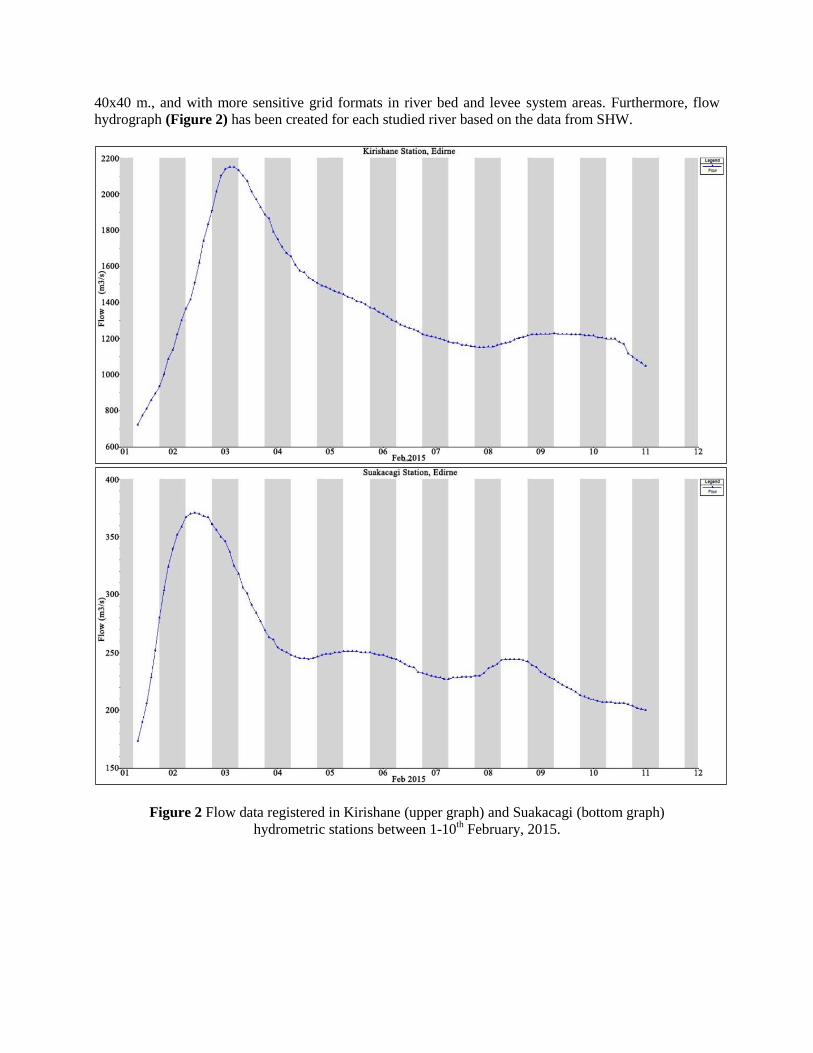
40x40 m., and with more sensitive grid formats in river bed and levee system areas. Furthermore, flow
hydrograph (Figure 2) has been created for each studied river based on the data from SHW.
Figure 2 Flow data registered in Kirishane (upper graph) and Suakacagi (bottom graph)
hydrometric stations between 1-10th February, 2015.
4. Results
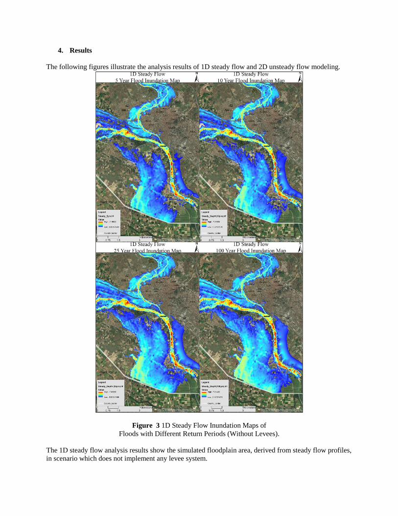
The following figures illustrate the analysis results of 1D steady flow and 2D unsteady flow modeling.
Figure 3 1D Steady Flow Inundation Maps of
Floods with Different Return Periods (Without Levees).
The 1D steady flow analysis results show the simulated floodplain area, derived from steady flow profiles,
in scenario which does not implement any levee system.
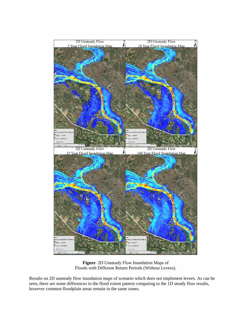
Figure 2D Unsteady Flow Inundation Maps of
Floods with Different Return Periods (Without Levees).
Results on 2D unsteady flow inundation maps of scenario which does not implement levees. As can be
seen, there are some differences in the flood extent pattern comparing to the 1D steady flow results,
however common floodplain areas remain in the same zones.
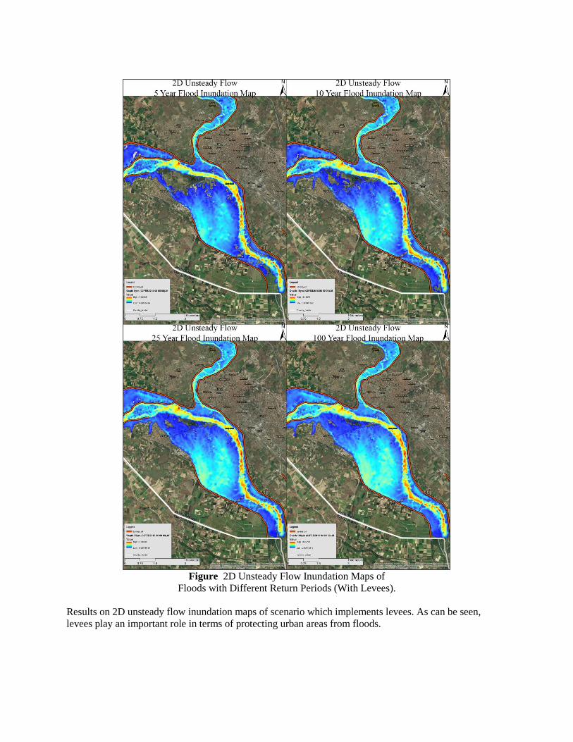
Figure 2D Unsteady Flow Inundation Maps of
Floods with Different Return Periods (With Levees).
Results on 2D unsteady flow inundation maps of scenario which implements levees. As can be seen,
levees play an important role in terms of protecting urban areas from floods.
5. Conclusion
Combined application of GIS and hydraulic modeling provides a researcher with significant number of
tools and opportunities for testing different outcomes and scenarios using the real-world/georeferenced
data. The present research tested two modeling approaches using the ArcGIS and HEC-RAS/HEC-
GeoRAS applications. Thus, 1D steady and 2D unsteady flow analysis have been realized which tested
scenarios that either included or not included existing levee system. The presented outcomes illustrate
floodplain maps of flood events with 5, 10, 25 and 100 year return periods. Applied approaches provided
mainly similar results, however unsteady flow, which has been calculated using the 2D mesh, represents
more relevant outcomes comparing to the 1D steady flow analysis. This is related to differences between
steady and unsteady flow regimes, as well as to computational approach that is applied in 1D and 2D
methods. Still, both methods can provide reliable results, while at the same time, the use of a particular
technique can depend on a channel type itself. The same point is relevant for unsteady and steady flow
regimes, as necessary flow type can be selected according to a dominant flow of an investigated hydraulic
system. For most of the river streams, unsteady might be a relevant option, especially in terms of that it
can provide a step-by-step simulation and its consecutive visualization. Finally, developed scenarios allow
to see the importance of the levee system in terms of floods in Edirne city, as well as to determine areas
that still get affected by water, even if they are protected by a levee. Therefore, the presented research is
expected to serve as a valuable reference for further studies related to the flood natural disaster in the case
study area, as well as for researches regarding the joint application of hydraulic modeling and GIS.
6. Biographies
Fuad Hajibayov
Fuad is currently a Master student at Istanbul Technical University, program of Urban Planning. He also
holds the Bachelor degree in Architecture. His fields of interests include modeling and simulations of
natural disasters and their consecutive impacts on urban form, as well as modeling using the advanced
planning techniques and GIS.
Asst. Prof. Dr. Basak Demires Ozkul
Basak Demires Ozkul is a Professor at Istanbul Technical University. At the same time, Dr. Basak is the
advisor of Fuad Hajibayov in his Master thesis titled as “Evaluating the Impacts of Floods on Planning in
Edirne City in Terms of Climate Change”. Dr. Basak’s research interests are related to the mobilities and
socio-economic transformation in terms of urban planning.
Assoc. Prof. Dr. Fatih Terzi
Fatih Terzi is a Professor at Istanbul Technical University. His past academic activities also include
teaching in Department of Landscape Architecture at Clemson University, USA, as well as a visit to the
Center of Advanced Spatial Analysis (CASA) at University College London as an Academic Affiliate. The
research interests of Dr. Terzi are related to housing and site planning, spatial development, GIS and
urban modeling.
7. References
Cameron, T., & Ackerman, P. E. (2009). HEC-GeoRAS GIS Tools for Support of HEC-RAS using ArcGIS.
Institute for Water Resources Hydrologic Engineering Center (HEC) 609 Second Street Davis,
CA 95616-4687: US Army Corps of Engineers Hydrologic Engineering Center.
Gary W. Brunner. (2016). HecRAS Hydraulic Reference Manual. Institute for Water Resources
Hydrologic Engineering Center (HEC) 609 Second Street Davis, CA 95616-4687: US Army
Corps of Engineers Hydrologic Engineering Center.
Gary W. Brunner, & CEIWR-HEC. (2016). HecRAS River Analysis System. Institute for Water Resources
Hydrologic Engineering Center (HEC) 609 Second Street Davis, CA 95616-4687: US Army
Corps of Engineers Hydrologic Engineering Center.
Tuncok, I. K. (2015). Transboundary river basin flood forecasting and early warning system experience in
Maritza River basin between Bulgaria and Turkey. Natural Hazards, 75(1), 191-214.
UNECE. (2011). Second Assessment of transboundary rivers, lakes and groundwaters (Vol. 1). United
Nations, Geneva: United Nations Publications.