Embed Size (px)
Citation preview
FlatbushAvenue
Flatbush Avenue
Empire Boulevard
Church Avenue
Foster Avenue
Kings High
way
Avenue U
!
!
!
!
±
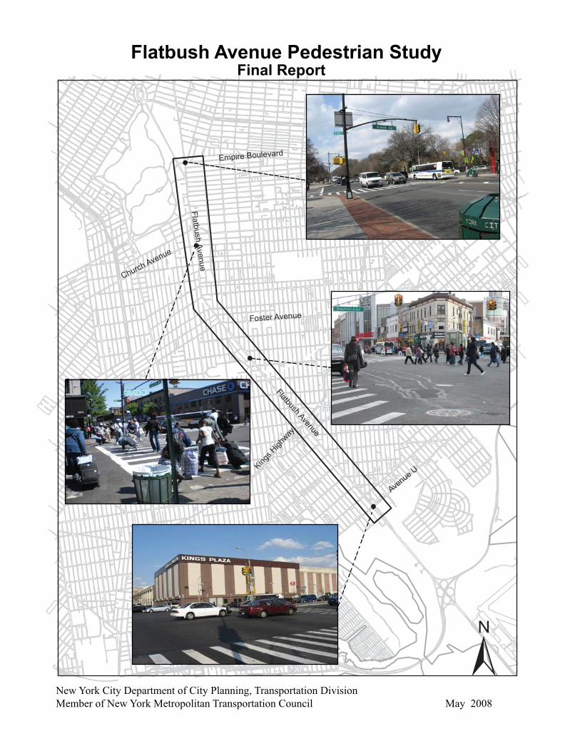
Flatbush Avenue Pedestrian Study
New York City Department of City Planning, Transportation DivisionMember of New York Metropolitan Transportation Council May 2008
Final Report

Flatbush Avenue Pedestrian Study
Michael R. Bloomberg, MayorCity of New York
Amanda M. Burden, AICP, DirectorNew York City Department of City Planning
FINAL REPORT May 2008


UPWP PIN Number: PTCP07G00.05
This study is funded under the Unified Planning Work Program (UPWP). The preparation of this report has been financed in part through funds from the US Department of Transportation, Federal Highway Administration. This document is disseminated under the sponsorship of the Department of Transportation in the interest of information exchange. The contents of this report reflect the view of the author, who is responsible for the facts and the accuracy of the data presented herein. The contents do not necessarily reflect the official views or policies of the Federal Highway Administration or the New York Metropolitan Transportation Council. This report does not constitute a standard, specification or regulation.

Table of Contents
Executive Summary 1Part A – Study Area and Socioeconomic Characteristics 3Introduction 5Study Area 5Socioeconomic Characteristics 8Part B - Zoning and Land Use 17Zoning 19Land Use 29Part C - Study Locations Analysis 37Major Study Locations Analysis & Recommendations 41Secondary Study Locations Analysis & Recommendations 79Other Study Locations Analysis & Recommendations 161Conclusion 168References 169Part D – Appendices 171Appendix D-1 LOS Methodology and Vehicular and Pedestrian Traffic Volumes 172Appendix D-2: Standards for Sign Recommendations 204Appendix D-3: Standards for Bus Shelter 208Appendix D-4: Tree Planting Guidelines 210Appendix D-5: Literature Search 214Credits 222
FiguresA-1 Regional Context 6A-2 Study Area 7A-3 Census Tracts Map of Study Area 8A-4 Vehicle Ownership by Household 12B-1 Overview Zoning Map 20B-2 Zoning Map - Section 1 of 4 25B-3 Zoning Map - Section 2 of 4 26B-4 Zoning Map - Section 3 of 4 27B-5 Zoning Map - Section 4 of 4 28B-6 Land Use Map - Section 1 of 4 31B-7 Land Use Map - Section 2 of 4 32B-8 Land Use Map - Section 3 of 4 33B-9 Land Use Map - Section 4 of 4 34C-1a Church Avenue Existing Conditions 50C-1b Church Avenue Recommendations 51C-2a Foster Avenue Existing Conditions 61C-2b Foster Avenue Recommendations 62C-3a Avenue U Existing Conditions 69C-3b Avenue U Recommendations 70C-4a Avenue U & Avenue V Existing Conditions 75C-4b Avenue U & Avenue V Recommendations 76C-5a Empire Boulevard Existing Conditions 85C-5b Empire Boulevard Recommendations 86C-6a Winthrop Street Existing Conditions 90C-6b Winthrop Street Recommendations 91C-7a Parkside Avenue Existing Conditions 97C-7b Parkside Avenue Recommendations 98C-8a Martense Street Existing Conditions 102C-8b Martense Street Recommendations 103C-9a Cortelyou Road Existing Conditions 109C-9b Cortelyou Road Recommendations 110C-10a Clarendon Road Existing Conditions 114C-10b Clarendon Road Recommendations 115C-11a Avenue D Existing Conditions 121C-11b Avenue D Recommendations 122C-12a Newkirk Avenue Existing Conditions 126C-12b Newkirk Avenue Recommendations 127
C-13a Glenwood Road Existing Conditions 134C-13b Glenwood Road Recommendations 135C-14a Nostrand Avenue Existing Conditions 141C-14b Nostrand Avenue Recommendations 142C-15a Avenue H Existing Conditions 147C-15b Avenue H Recommendations 148C-16a Kings Highway Existing Conditions 152C-16b Kings Highway Recommendations 153C-17a Utica Avenue Existing Conditions 158C-17b Utica Avenue Recommendations 159C-18a East 26th Street Existing Conditions 166C-18b East 26th Street Recommendations 167Int -1 Flatbush Avenue and Church Avenue – Schematic Diagram of Walkways 175Int -2 Flatbush/Bedford Aves and Foster Ave – Schematic Diagram of Walkways 176Int -3 Flatbush Avenue and Avenue U – Schematic Diagram of Walkways 1771 Church Avenue AM Vehicular Volumes 1792 Church Avenue MD Vehicular Volumes 1803 Church Avenue PM Vehicular Volumes 1814 Church Avenue Saturday Vehicular Volumes 1825 Church Avenue AM Pedestrian Volumes 1836 Church Avenue MD Pedestrian Volumes 1847 Church Avenue PM Pedestrian Volumes 1858 Church Avenue Saturday Pedestrian Volumes 1869 Foster Avenue AM Vehicular Volumes 18710 Foster Avenue MD Vehicular Volumes 18811 Foster Avenue PM Vehicular Volumes 18912 Foster Avenue Saturday Vehicular Volumes 19013 Foster Avenue AM Pedestrian Volumes 19114 Foster Avenue MD Pedestrian Volumes 19215 Foster Avenue PM Pedestrian Volumes 19316 Foster Avenue Saturday Pedestrian Volumes 19417 Avenue U AM Vehicular Volumes 19518 Avenue U MD Vehicular Volumes 19619 Avenue U PM Vehicular Volumes 19720 Avenue U Saturday Vehicular Volumes 19821 Avenue U AM Pedestrian Volumes 19922 Avenue U MD Pedestrian Volumes 20023 Avenue U PM Pedestrian Volumes 20124 Avenue U Saturday Pedestrian Volumes 202
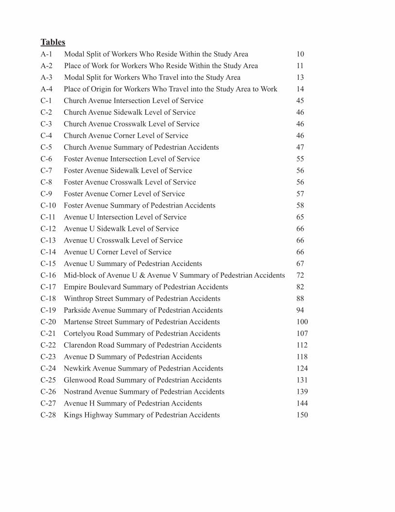
TablesA-1 Modal Split of Workers Who Reside Within the Study Area 10A-2 Place of Work for Workers Who Reside Within the Study Area 11A-3 Modal Split for Workers Who Travel into the Study Area 13A-4 Place of Origin for Workers Who Travel into the Study Area to Work 14C-1 Church Avenue Intersection Level of Service 45C-2 Church Avenue Sidewalk Level of Service 46C-3 Church Avenue Crosswalk Level of Service 46C-4 Church Avenue Corner Level of Service 46C-5 Church Avenue Summary of Pedestrian Accidents 47C-6 Foster Avenue Intersection Level of Service 55C-7 Foster Avenue Sidewalk Level of Service 56C-8 Foster Avenue Crosswalk Level of Service 56C-9 Foster Avenue Corner Level of Service 57C-10 Foster Avenue Summary of Pedestrian Accidents 58C-11 Avenue U Intersection Level of Service 65C-12 Avenue U Sidewalk Level of Service 66C-13 Avenue U Crosswalk Level of Service 66C-14 Avenue U Corner Level of Service 66C-15 Avenue U Summary of Pedestrian Accidents 67C-16 Mid-block of Avenue U & Avenue V Summary of Pedestrian Accidents 72C-17 Empire Boulevard Summary of Pedestrian Accidents 82C-18 Winthrop Street Summary of Pedestrian Accidents 88C-19 Parkside Avenue Summary of Pedestrian Accidents 94C-20 Martense Street Summary of Pedestrian Accidents 100C-21 Cortelyou Road Summary of Pedestrian Accidents 107C-22 Clarendon Road Summary of Pedestrian Accidents 112C-23 Avenue D Summary of Pedestrian Accidents 118C-24 Newkirk Avenue Summary of Pedestrian Accidents 124C-25 Glenwood Road Summary of Pedestrian Accidents 131C-26 Nostrand Avenue Summary of Pedestrian Accidents 139C-27 Avenue H Summary of Pedestrian Accidents 144C-28 Kings Highway Summary of Pedestrian Accidents 150


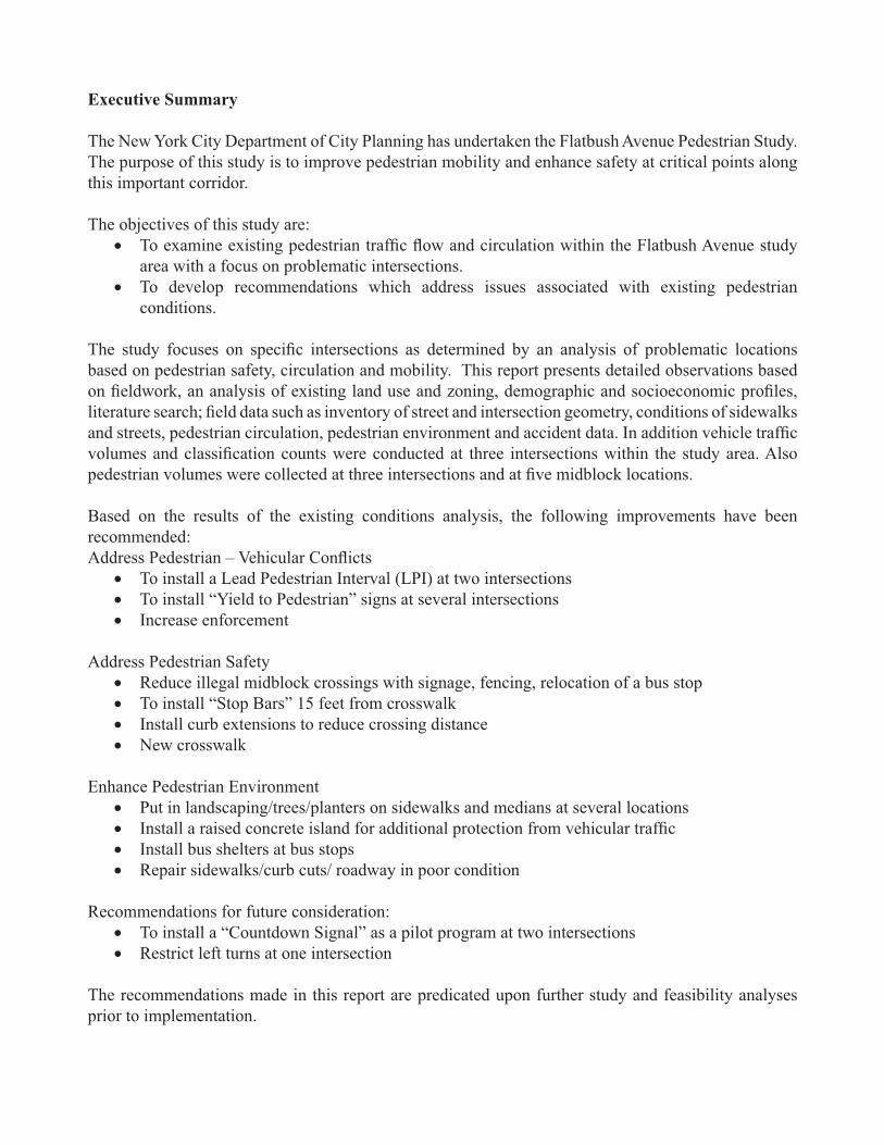
Executive Summary
The New York City Department of City Planning has undertaken the Flatbush Avenue Pedestrian Study. The purpose of this study is to improve pedestrian mobility and enhance safety at critical points along this important corridor. The objectives of this study are:
To examine existing pedestrian traffic flow and circulation within the Flatbush Avenue study • area with a focus on problematic intersections.To develop recommendations which address issues associated with existing pedestrian • conditions.
The study focuses on specific intersections as determined by an analysis of problematic locations based on pedestrian safety, circulation and mobility. This report presents detailed observations based on fieldwork, an analysis of existing land use and zoning, demographic and socioeconomic profiles, literature search; field data such as inventory of street and intersection geometry, conditions of sidewalks and streets, pedestrian circulation, pedestrian environment and accident data. In addition vehicle traffic volumes and classification counts were conducted at three intersections within the study area. Also pedestrian volumes were collected at three intersections and at five midblock locations.
Based on the results of the existing conditions analysis, the following improvements have been recommended:Address Pedestrian – Vehicular Conflicts
To install a Lead Pedestrian Interval (LPI) at two intersections• To install “Yield to Pedestrian” signs at several intersections• Increase enforcement •
Address Pedestrian Safety Reduce illegal midblock crossings with signage, fencing, relocation of a bus stop• To install “Stop Bars” 15 feet from crosswalk • Install curb extensions to reduce crossing distance• New crosswalk•
Enhance Pedestrian EnvironmentPut in landscaping/trees/planters on sidewalks and medians at several locations• Install a raised concrete island for additional protection from vehicular traffic• Install bus shelters at bus stops• Repair sidewalks/curb cuts/ roadway in poor condition•
Recommendations for future consideration:To install a “Countdown Signal” as a pilot program at two intersections• Restrict left turns at one intersection•
The recommendations made in this report are predicated upon further study and feasibility analyses prior to implementation.

Demographics
Flatbush Avenue Pedestrian Study
2
Demographics
Flatbush Avenue Pedestrian Study
3
Part A
Study Area and Socioeconomic Characteristics

Demographics
Flatbush Avenue Pedestrian Study
4
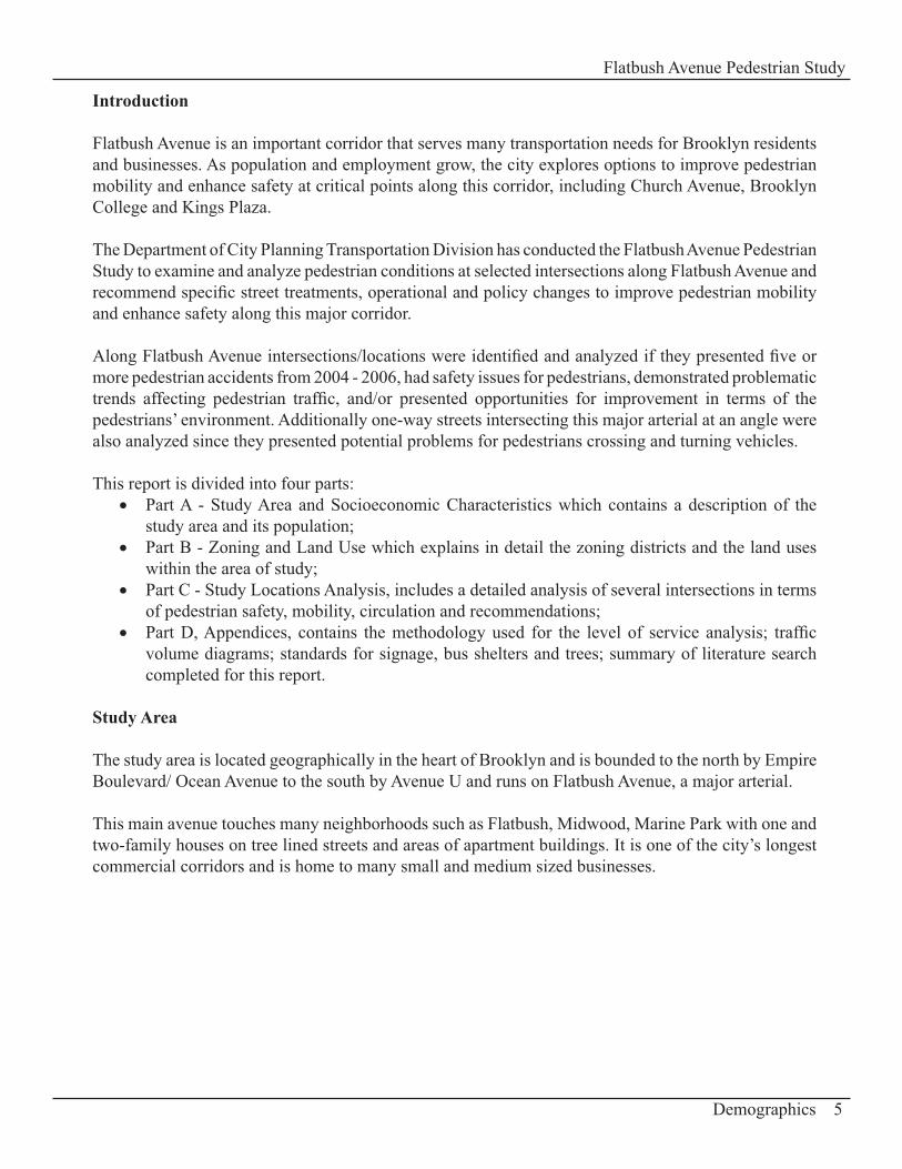
Introduction
Flatbush Avenue is an important corridor that serves many transportation needs for Brooklyn residents and businesses. As population and employment grow, the city explores options to improve pedestrian mobility and enhance safety at critical points along this corridor, including Church Avenue, Brooklyn College and Kings Plaza.
The Department of City Planning Transportation Division has conducted the Flatbush Avenue Pedestrian Study to examine and analyze pedestrian conditions at selected intersections along Flatbush Avenue and recommend specific street treatments, operational and policy changes to improve pedestrian mobility and enhance safety along this major corridor.
Along Flatbush Avenue intersections/locations were identified and analyzed if they presented five or more pedestrian accidents from 2004 - 2006, had safety issues for pedestrians, demonstrated problematic trends affecting pedestrian traffic, and/or presented opportunities for improvement in terms of the pedestrians’ environment. Additionally one-way streets intersecting this major arterial at an angle were also analyzed since they presented potential problems for pedestrians crossing and turning vehicles.
This report is divided into four parts: Part A - Study Area and Socioeconomic Characteristics which contains a description of the • study area and its population; Part B - Zoning and Land Use which explains in detail the zoning districts and the land uses • within the area of study; Part C - Study Locations Analysis, includes a detailed analysis of several intersections in terms • of pedestrian safety, mobility, circulation and recommendations;Part D, Appendices, contains the methodology used for the level of service analysis; traffic • volume diagrams; standards for signage, bus shelters and trees; summary of literature search completed for this report.
Study Area
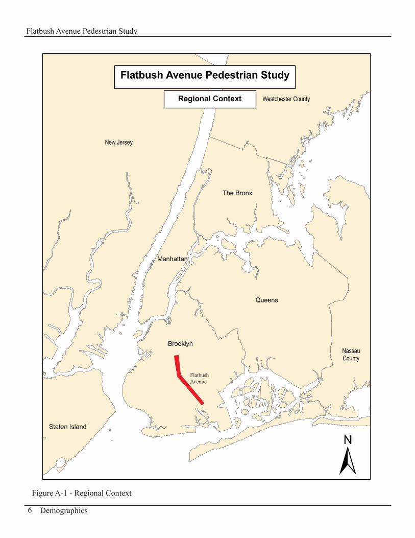
The study area is located geographically in the heart of Brooklyn and is bounded to the north by Empire Boulevard/ Ocean Avenue to the south by Avenue U and runs on Flatbush Avenue, a major arterial.
This main avenue touches many neighborhoods such as Flatbush, Midwood, Marine Park with one and two-family houses on tree lined streets and areas of apartment buildings. It is one of the city’s longest commercial corridors and is home to many small and medium sized businesses.
Demographics
Flatbush Avenue Pedestrian Study
5
Staten Island
Queens
The Bronx
Manhattan
Brooklyn
New Jersey
Westchester County
NassauCounty
Flatbush Avenue Pedestrian Study
Regional Context
±Demographics
Flatbush Avenue Pedestrian Study
6
Flatbush Avenue
Figure A-1 - Regional Context
Demographics
Flatbush Avenue Pedestrian Study
7
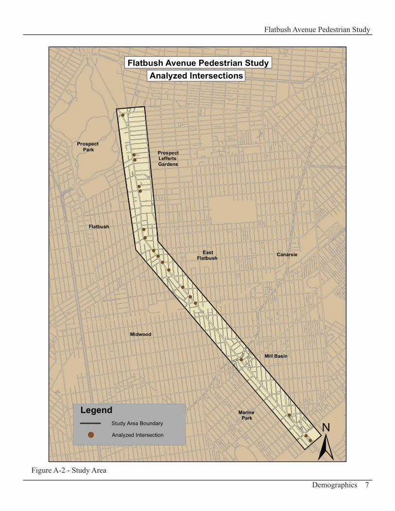
Figure A-2 - Study Area
Flatbush Avenue Pedestrian StudyAnalyzed Intersections
±
Prospect Park
Midwood
Marine Park
EastFlatbush
Flatbush
ProspectLefferts Gardens
Mill Basin
Canarsie
!
!
!
!!
!
!
!
!
!
!
!
!
!
!
!
!!
LegendStudy Area Boundary
Analyzed Intersection
Socioeconomic Characteristics
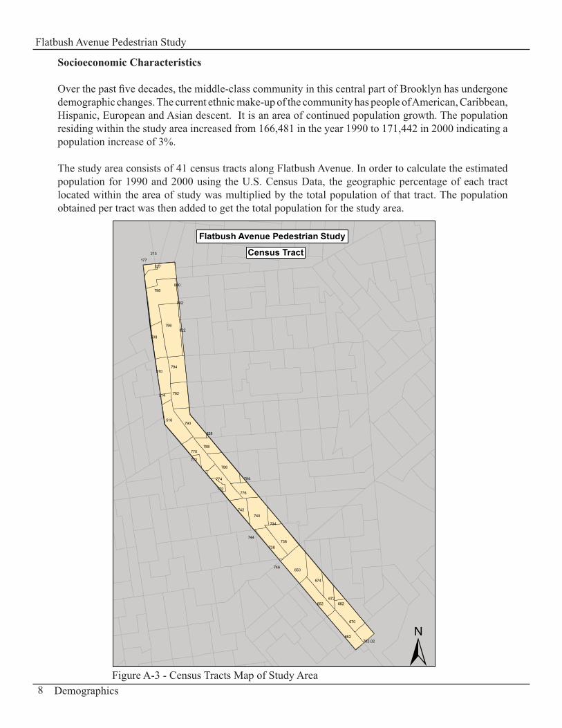
Over the past five decades, the middle-class community in this central part of Brooklyn has undergone demographic changes. The current ethnic make-up of the community has people of American, Caribbean, Hispanic, European and Asian descent. It is an area of continued population growth. The population residing within the study area increased from 166,481 in the year 1990 to 171,442 in 2000 indicating a population increase of 3%.
The study area consists of 41 census tracts along Flatbush Avenue. In order to calculate the estimated population for 1990 and 2000 using the U.S. Census Data, the geographic percentage of each tract located within the area of study was multiplied by the total population of that tract. The population obtained per tract was then added to get the total population for the study area.
Flatbush Avenue Pedestrian Study
Census Tract177
213
327
798800
802
796
508
822
510794
792514
516790
770788
828
786
772
774 784
776772
742740
734
736738
744
746650
674
652672
662
682
670
702.02 ±Demographics
Flatbush Avenue Pedestrian Study
8Figure A-3 - Census Tracts Map of Study Area
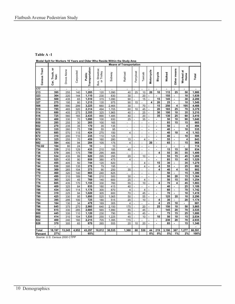
Due to rounding in the CTPP and Census policies, there are differences between the total workers for the Modal Split (66,591) and for the Place of Work (64,801), the difference is only 1,790 people or 3% .
A journey-to-work modal split analysis was also done for this study using data from the census tracts that make up the study area. Journey-to-work modal split analyses were performed for both the local resident labor force and the people who traveled into the study area to work.
2000 census data indicates that the study area had a local resident labor force (16 years or older) of 66,591 workers who either worked at home or commuted to work. Of the total local resident labor force, 27 percent (18,197) used car, truck or van, and either drove alone or carpooled (see Table A-1). The majority of the car, truck or van usage occurred by those who drove alone (72.8 percent). Of the remaining local resident labor force, 65 percent (43,297) used public transit, 5 percent (3,190) walked to work, and 2 percent (1,277) worked at home. For those workers who commuted using public transportation, 70.5 percent (30,535) were by subways, 25 percent (10,812) by bus, 3.1 per-cent (1,360) by railroad, 1 percent (530) by taxicab, And 1 percent (367) by other means.
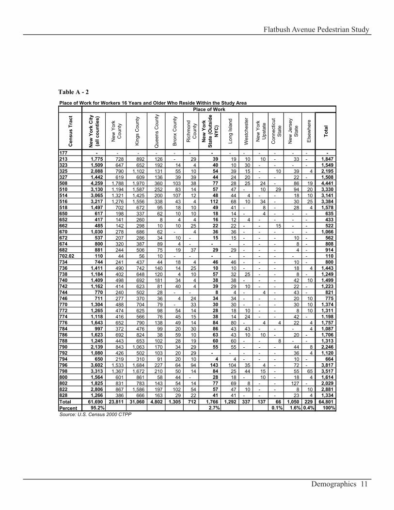
With regard to place of work data for the 2000 Census, 95 percent (61,690) of the local resident labor force (16 years or older) worked in New York City, while the remaining 5 percent (3,111) worked in various places outside of New York City. Of the local resident labor force who worked in New York City, 50.3 percent (31,060) worked in Kings County, 38.6 percent (23,811) worked in New York County, 7.8 percent (4,802) worked in Queens County, 2.1 percent (1,305) worked in Bronx County, and 1.2 percent (712) worked in Richmond County. The remaining local resident labor force worked in New York State outside of New York City (2.7 percent), New Jersey (1.6 percent), Connecticut (0.1 percent), and elsewhere (0.4 percent). See Table A-2.
Demographics
Flatbush Avenue Pedestrian Study
9
Modal Split for Workers 16 Years and Older Who Reside Within the Study Area
Cen
sus
Trac
t
Car
, Tru
ck, o
r Va
n:
Dro
ve A
lone
Car
pool
ed
Publ
ic
Tran
spor
tatio
n
Bus
, Stre
etca
r,
or T
rolle
y
Sub
way
Rai
lroad
Ferr
yboa
t
Taxi
cab
Mot
orcy
cle
Bic
ycle
Wal
ked
Oth
er m
eans
Wor
ked
at
Hom
e
Tota
l
177 - - - - - - - - - - - - - - - 213 395 255 140 1,285 120 1,090 40 25 10 20 10 115 25 50 1,900 323 364 220 144 1,110 230 830 30 - 20 - - 155 - 10 1,639 325 500 435 65 1,510 315 1,090 90 - 15 - 15 145 - 30 2,200 327 275 195 80 1,215 135 975 90 15 - 4 20 25 - 10 1,549 508 889 590 299 3,225 660 2,465 30 - 70 - 15 250 4 105 4,488 510 785 465 320 2,314 494 1,705 60 10 45 - 20 165 25 70 3,379 514 680 405 275 2,355 325 1,965 40 - 25 - 30 100 10 35 3,210 516 725 560 165 2,435 890 1,485 40 - 20 - 35 130 25 60 3,410 518 400 330 70 1,090 100 930 25 - 35 - - 50 10 90 1,640 650 285 255 30 265 100 165 - - - - - 85 15 15 665 652 270 235 35 170 35 135 - - - - - 50 - 4 494 662 335 260 75 150 55 95 - - - - - 40 - 10 535 670 685 570 115 424 270 150 4 - - - - 40 10 4 1,163 672 310 200 110 235 110 125 - - - - - 40 - 10 595 674 325 255 70 459 160 280 15 - 4 - - 55 - 4 843 682 584 490 94 284 105 175 4 - - 20 - 65 - 15 968 702.02 104 80 24 10 - 10 - - - - - - - - 114 734 339 210 129 435 210 185 40 - - - - 15 15 30 834 736 570 395 175 780 295 485 - - - - 4 55 35 55 1,499 738 534 435 99 620 295 295 20 - 10 - - 55 15 45 1,269 740 525 435 90 859 380 475 4 - - - - 85 15 45 1,529 742 455 405 50 744 120 620 - - 4 - 15 30 - 35 1,279 744 530 395 135 278 79 195 - - 4 - 4 55 - 25 892 746 369 265 104 375 90 250 35 - - - 4 40 4 10 802 770 460 320 140 865 240 625 - - - - - 50 - 15 1,390 772 499 310 189 740 210 500 30 - - - - 90 20 15 1,364 774 365 320 45 769 140 600 25 - 4 - - 50 15 55 1,254 776 605 435 170 1,155 330 760 55 - 10 - 4 70 4 45 1,883 784 409 325 84 635 180 415 40 - - - - 40 - 25 1,109 786 434 320 114 1,178 300 870 4 - 4 - - 60 - 70 1,742 788 319 225 94 1,020 305 600 70 - 45 - - 70 - 10 1,419 790 425 330 95 1,695 525 1,065 50 - 55 - - 125 35 10 2,290 792 395 295 100 725 180 515 20 - 10 - 4 30 - 20 1,174 794 164 130 34 478 169 305 4 - - - 4 25 10 - 681 796 645 375 270 2,985 640 2,150 175 - 20 - 25 150 10 50 3,865 798 615 330 285 2,685 565 1,990 85 - 45 - - 145 20 70 3,535 800 445 335 110 1,120 230 790 55 - 45 - - 75 15 25 1,680 802 414 310 104 1,535 255 1,225 45 - 10 - 10 50 10 15 2,034 822 400 240 160 2,215 705 1,395 115 - - - - 230 20 70 2,935 828 370 305 65 870 265 555 20 10 20 - - 85 - 15 1,340
- - - Total 18,197 13,245 4,952 43,297 10,812 30,535 1,360 60 530 44 219 3,190 367 1,277 66,591 Percent 27% 65% 0% 0% 5% 1% 2% 100%Source: U.S. Census 2000 CTPP
Means of Transportation
Table A -1
Demographics
Flatbush Avenue Pedestrian Study
10
Place of Work for Workers 16 Years and Older Who Reside Within the Study Area
Cen
sus
Trac
t
New
Yor
k C
ity
(all
coun
ties)
New
Yor
k C
ount
y
Kin
gs C
ount
y
Que
ens
Cou
nty
Bro
nx C
ount
y
Ric
hmon
d C
ount
y
New
Yor
k St
ate
(Out
side
N
YC)
Long
Isla
nd
Wes
tche
ster
New
Yor
k U
psta
te
Con
nect
icut
S
tate
New
Jer
sey
Sta
te
Els
ewhe
re
Tota
l
177 - - - - - - - - - - - - - - 213 1,775 728 892 126 - 29 39 19 10 10 - 33 - 1,847 323 1,509 647 652 192 14 4 40 10 30 - - - - 1,549 325 2,088 790 1,102 131 55 10 54 39 15 - 10 39 4 2,195 327 1,442 619 609 136 39 39 44 24 20 - - 22 - 1,508 508 4,259 1,788 1,970 360 103 38 77 28 25 24 - 86 19 4,441 510 3,130 1,194 1,587 252 83 14 57 47 - 10 29 94 20 3,330 514 3,065 1,321 1,425 200 107 12 48 44 4 - - 18 10 3,141 516 3,217 1,276 1,556 338 43 4 112 68 10 34 - 30 25 3,384 518 1,497 702 672 95 18 10 49 41 - 8 - 28 4 1,578 650 617 198 337 62 10 10 18 14 - 4 - - - 635 652 417 141 260 8 4 4 16 12 4 - - - - 433 662 485 142 298 10 10 25 22 22 - - 15 - - 522 670 1,030 278 686 62 - 4 36 36 - - - - - 1,066 672 537 207 286 34 10 - 15 15 - - - 10 - 562 674 800 320 387 89 4 - - - - - - 8 - 808 682 881 244 506 75 19 37 29 29 - - - 4 - 914 702.02 110 44 56 10 - - - - - - - - - 110 734 744 241 437 44 18 4 46 46 - - - 10 - 800 736 1,411 490 742 140 14 25 10 10 - - - 18 4 1,443 738 1,184 402 648 120 4 10 57 32 25 - - 8 - 1,249 740 1,409 498 692 181 34 4 38 38 - - - 42 10 1,499 742 1,162 414 623 81 40 4 39 29 10 - - 22 - 1,223 744 770 240 502 28 - - 8 4 - 4 - 43 - 821 746 711 277 370 36 4 24 34 34 - - - 20 10 775 770 1,304 488 704 79 - 33 30 30 - - - 30 10 1,374 772 1,265 474 625 98 54 14 28 18 10 - - 8 10 1,311 774 1,118 416 566 76 45 15 38 14 24 - - 42 - 1,198 776 1,643 652 790 138 49 14 84 80 - 4 4 22 4 1,757 784 997 372 476 99 20 30 86 43 43 - - - 4 1,087 786 1,623 692 824 38 59 10 63 43 10 10 - 20 - 1,706 788 1,245 443 653 102 28 19 60 60 - - 8 - - 1,313 790 2,139 843 1,063 170 34 29 55 55 - - - 44 8 2,246 792 1,080 426 502 103 20 29 - - - - - 36 4 1,120 794 650 219 310 91 20 10 4 4 - - - 10 - 664 796 3,602 1,533 1,684 227 64 94 143 104 35 4 - 72 - 3,817 798 3,313 1,367 1,672 210 50 14 84 25 44 15 - 55 65 3,517 800 1,564 601 861 58 44 - 28 18 - 10 - 18 4 1,614 802 1,825 831 783 143 54 14 77 69 8 - - 127 - 2,029 822 2,806 867 1,586 197 102 54 57 47 10 - - 8 10 2,881 828 1,266 386 666 163 29 22 41 41 - - - 23 4 1,334 Total 61,690 23,811 31,060 4,802 1,305 712 1,766 1,292 337 137 66 1,050 229 64,801 Percent 95.2% 2.7% 0.1% 1.6% 0.4% 100%Source: U.S. Census 2000 CTPP
Place of Work
Table A - 2
Demographics
Flatbush Avenue Pedestrian Study
11
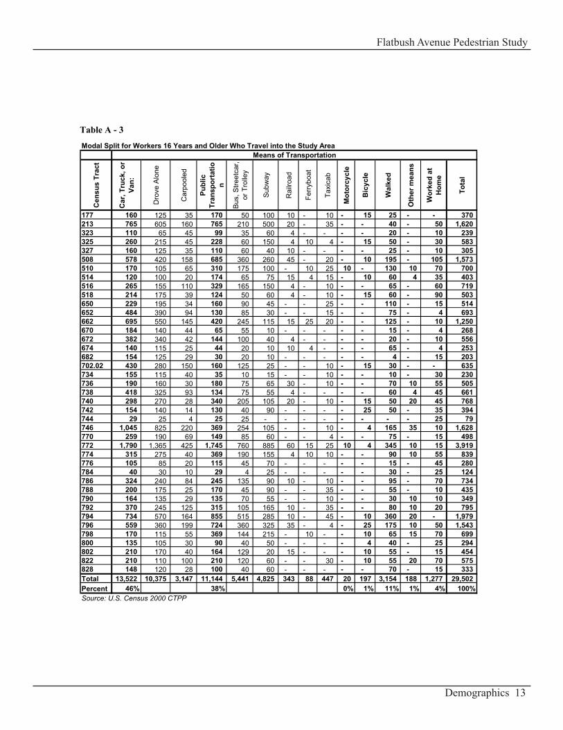
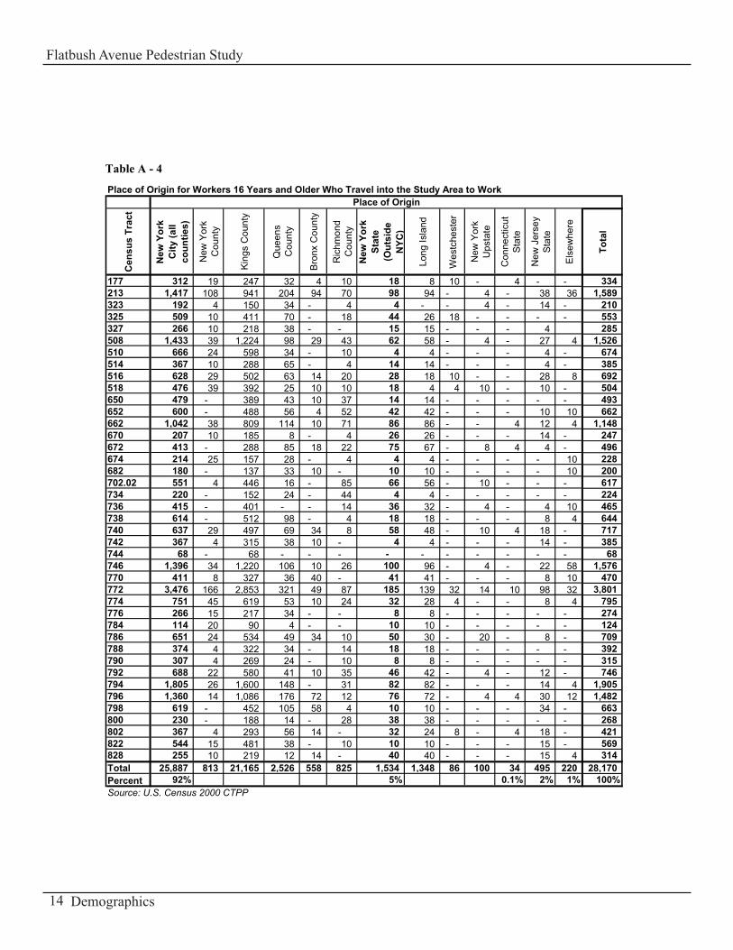
Due to rounding in the CTPP and Census policies, there are differences between the total workers for the Modal Split (29,502) and for the Place of Origin (28,170), the difference is only 1,332 people or 4.5% .
2000 census data indicates that the study area had a labor force (16 years or older) of 29,502 work-ers who traveled into the study area to work (inbound labor force) (see Table A-3). Of the total in-bound labor force, 46 percent (13,522) used car, truck or van, either driving alone or carpooling. The bulk of the car, truck or van usage came from people who drove alone (76.7 percent). Of the remain-ing inbound labor force, 38 percent (11,144) used public transit, 11 percent (3,154) walked to work, 1 percent (197) bicycled, 1 percent (205) used other means of transportation, and 4 percent worked at home. For those workers who commuted using public transit, 43 percent (4,825) was on subways, 49 percent (5,441) on bus, 3 percent (343) on rail road, and 4 percent (447) on taxicab.
With regard to place of origin, 92 percent (25,887) of the inbound labor force (16 years or older) resided in New York City, while the remaining 8 percent (2,283) resided in various places outside of New York City. Of the inbound labor force who resided in New York City, 82 percent (21,165) re-sided in Kings County, 10 percent (2,526) resided in Queens County, 3 percent (813) resided in New York County, 2 percent (558) resided in Bronx County, and 3 percent (825) resided in Richmond County. The remaining inbound labor force resided in New York State outside of New York City (5 percent), Connecticut (0.1 percent), New Jersey (2 percent), and elsewhere (1 percent). See Table A-4.
Based on this analysis of the journey-to-work 2000 census data, the local resident and the inbound labor forces that make use of public transportation or walk to and from work within the study area significantly contribute to the number of pedestrians on the streets in the area of study and are part of the street network on a daily basis.
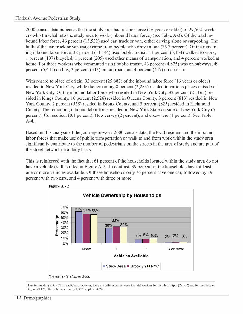
This is reinforced with the fact that 61 percent of the households located within the study area do not have a vehicle as illustrated in Figure A-2. In contrast, 39 percent of the households have at least one or more vehicles available. Of these households only 76 percent have one car, followed by 19 percent with two cars, and 4 percent with three or more.
Vehicle Ownership by Households
7% 8%
61%
30%
2%
57%
33%
2%
56%
32%
10% 3%
0%10%20%30%40%50%60%70%
None 1 2 3 or more
Vehicles Available
Perc
enta
ge
Study Area Brooklyn NYC
Figure A - 2
Source: U.S. Census 2000
Demographics
Flatbush Avenue Pedestrian Study
12
Modal Split for Workers 16 Years and Older Who Travel into the Study Area
Cen
sus
Trac
t
Car
, Tru
ck, o
r Va
n:
Dro
ve A
lone
Car
pool
ed
Publ
ic
Tran
spor
tatio
n
Bus
, Stre
etca
r, or
Tro
lley
Sub
way
Rai
lroad
Ferr
yboa
t
Taxi
cab
Mot
orcy
cle
Bic
ycle
Wal
ked
Oth
er m
eans
Wor
ked
at
Hom
e
Tota
l
177 160 125 35 170 50 100 10 - 10 - 15 25 - - 370 213 765 605 160 765 210 500 20 - 35 - - 40 - 50 1,620 323 110 65 45 99 35 60 4 - - - - 20 - 10 239 325 260 215 45 228 60 150 4 10 4 - 15 50 - 30 583 327 160 125 35 110 60 40 10 - - - - 25 - 10 305 508 578 420 158 685 360 260 45 - 20 - 10 195 - 105 1,573 510 170 105 65 310 175 100 - 10 25 10 - 130 10 70 700 514 120 100 20 174 65 75 15 4 15 - 10 60 4 35 403 516 265 155 110 329 165 150 4 - 10 - - 65 - 60 719 518 214 175 39 124 50 60 4 - 10 - 15 60 - 90 503 650 229 195 34 160 90 45 - - 25 - - 110 - 15 514 652 484 390 94 130 85 30 - - 15 - - 75 - 4 693 662 695 550 145 420 245 115 15 25 20 - - 125 - 10 1,250 670 184 140 44 65 55 10 - - - - - 15 - 4 268 672 382 340 42 144 100 40 4 - - - - 20 - 10 556 674 140 115 25 44 20 10 10 4 - - - 65 - 4 253 682 154 125 29 30 20 10 - - - - - 4 - 15 203 702.02 430 280 150 160 125 25 - - 10 - 15 30 - - 635 734 155 115 40 35 10 15 - - 10 - - 10 - 30 230 736 190 160 30 180 75 65 30 - 10 - - 70 10 55 505 738 418 325 93 134 75 55 4 - - - - 60 4 45 661 740 298 270 28 340 205 105 20 - 10 - 15 50 20 45 768 742 154 140 14 130 40 90 - - - - 25 50 - 35 394 744 29 25 4 25 25 - - - - - - - - 25 79 746 1,045 825 220 369 254 105 - - 10 - 4 165 35 10 1,628 770 259 190 69 149 85 60 - - 4 - - 75 - 15 498 772 1,790 1,365 425 1,745 760 885 60 15 25 10 4 345 10 15 3,919 774 315 275 40 369 190 155 4 10 10 - - 90 10 55 839 776 105 85 20 115 45 70 - - - - - 15 - 45 280 784 40 30 10 29 4 25 - - - - - 30 - 25 124 786 324 240 84 245 135 90 10 - 10 - - 95 - 70 734 788 200 175 25 170 45 90 - - 35 - - 55 - 10 435 790 164 135 29 135 70 55 - - 10 - - 30 10 10 349 792 370 245 125 315 105 165 10 - 35 - - 80 10 20 795 794 734 570 164 855 515 285 10 - 45 - 10 360 20 - 1,979 796 559 360 199 724 360 325 35 - 4 - 25 175 10 50 1,543 798 170 115 55 369 144 215 - 10 - - 10 65 15 70 699 800 135 105 30 90 40 50 - - - - 4 40 - 25 294 802 210 170 40 164 129 20 15 - - - 10 55 - 15 454 822 210 110 100 210 120 60 - - 30 - 10 55 20 70 575 828 148 120 28 100 40 60 - - - - - 70 - 15 333 Total 13,522 10,375 3,147 11,144 5,441 4,825 343 88 447 20 197 3,154 188 1,277 29,502 Percent 46% 38% 0% 1% 11% 1% 4% 100%Source: U.S. Census 2000 CTPP
Means of Transportation
Table A - 3
Demographics
Flatbush Avenue Pedestrian Study
13
Place of Origin for Workers 16 Years and Older Who Travel into the Study Area to Work
Cen
sus
Trac
t
New
Yor
k C
ity (a
ll co
untie
s)
New
Yor
k C
ount
y
Kin
gs C
ount
y
Que
ens
Cou
nty
Bro
nx C
ount
y
Ric
hmon
d C
ount
yN
ew Y
ork
Stat
e (O
utsi
de
NYC
)
Long
Isla
nd
Wes
tche
ster
New
Yor
k U
psta
te
Con
nect
icut
S
tate
New
Jer
sey
Sta
te
Els
ewhe
re
Tota
l
177 312 19 247 32 4 10 18 8 10 - 4 - - 334 213 1,417 108 941 204 94 70 98 94 - 4 - 38 36 1,589 323 192 4 150 34 - 4 4 - - 4 - 14 - 210 325 509 10 411 70 - 18 44 26 18 - - - - 553 327 266 10 218 38 - - 15 15 - - - 4 285 508 1,433 39 1,224 98 29 43 62 58 - 4 - 27 4 1,526 510 666 24 598 34 - 10 4 4 - - - 4 - 674 514 367 10 288 65 - 4 14 14 - - - 4 - 385 516 628 29 502 63 14 20 28 18 10 - - 28 8 692 518 476 39 392 25 10 10 18 4 4 10 - 10 - 504 650 479 - 389 43 10 37 14 14 - - - - - 493 652 600 - 488 56 4 52 42 42 - - - 10 10 662 662 1,042 38 809 114 10 71 86 86 - - 4 12 4 1,148 670 207 10 185 8 - 4 26 26 - - - 14 - 247 672 413 - 288 85 18 22 75 67 - 8 4 4 - 496 674 214 25 157 28 - 4 4 4 - - - - 10 228 682 180 - 137 33 10 - 10 10 - - - - 10 200 702.02 551 4 446 16 - 85 66 56 - 10 - - - 617 734 220 - 152 24 - 44 4 4 - - - - - 224 736 415 - 401 - - 14 36 32 - 4 - 4 10 465 738 614 - 512 98 - 4 18 18 - - - 8 4 644 740 637 29 497 69 34 8 58 48 - 10 4 18 - 717 742 367 4 315 38 10 - 4 4 - - - 14 - 385 744 68 - 68 - - - - - - - - - - 68 746 1,396 34 1,220 106 10 26 100 96 - 4 - 22 58 1,576 770 411 8 327 36 40 - 41 41 - - - 8 10 470 772 3,476 166 2,853 321 49 87 185 139 32 14 10 98 32 3,801 774 751 45 619 53 10 24 32 28 4 - - 8 4 795 776 266 15 217 34 - - 8 8 - - - - - 274 784 114 20 90 4 - - 10 10 - - - - - 124 786 651 24 534 49 34 10 50 30 - 20 - 8 - 709 788 374 4 322 34 - 14 18 18 - - - - - 392 790 307 4 269 24 - 10 8 8 - - - - - 315 792 688 22 580 41 10 35 46 42 - 4 - 12 - 746 794 1,805 26 1,600 148 - 31 82 82 - - - 14 4 1,905 796 1,360 14 1,086 176 72 12 76 72 - 4 4 30 12 1,482 798 619 - 452 105 58 4 10 10 - - - 34 - 663 800 230 - 188 14 - 28 38 38 - - - - - 268 802 367 4 293 56 14 - 32 24 8 - 4 18 - 421 822 544 15 481 38 - 10 10 10 - - - 15 - 569 828 255 10 219 12 14 - 40 40 - - - 15 4 314 Total 25,887 813 21,165 2,526 558 825 1,534 1,348 86 100 34 495 220 28,170 Percent 92% 5% 0.1% 2% 1% 100%Source: U.S. Census 2000 CTPP
Place of Origin
Table A - 4
Demographics
Flatbush Avenue Pedestrian Study
14

Demographics
Flatbush Avenue Pedestrian Study
15

16 Zoning and Land Use
Flatbush Avenue Pedestrian Study
17Zoning and Land Use
Flatbush Avenue Pedestrian Study
Part B Zoning and Land Use

18 Zoning and Land Use
Flatbush Avenue Pedestrian Study
Zoning and Land Use The second part of this report gives an overview of the citywide zoning followed by a detailed description of the zoning districts along Flatbush Avenue within the area of study. Finally, a description of the land use surrounding Flatbush Avenue is provided.
ZoningHere is a brief overview of New York City’s zoning:There are three basic zoning designations within New York City: residential (R), commercial (C), and manufacturing (M). The three basic categories are further subdivided into lower, medium, and higher density of residential, commercial, and manufacturing districts. Development within these districts is regulated by use, bulk, and parking regulations.
Residential zoning districts range from R1 (the lowest density) to R10 (the highest density). R1 and R2 districts allow only detached single-family residences and certain community facilities. The R3-2 through R10 districts permit all types of dwelling units and community facilities and are distinguished by differing bulk and density, height and setback, parking, and lot coverage or open space requirements. However R2A, R2X, R3A, R3X, R3-1, R4-1, R5A, and R5-B permit limited types of one, two or three family houses depending on the residential district.
Commercial zoning districts range from C1 to C8. Of the eight basic commercial districts, two (C1 and C2 districts) are designed to serve local needs, one (C4 district) is for shopping centers outside the central business district, two (C5 and C6 districts) are for the central business districts, and three (C3, C7, and C8 districts) are designed for special purposes (waterfront activity, large commercial amusement parks and heavy repair services). The eight basic commercial districts are further subdivided to reflect variations in bulk, parking, and loading requirements.
Manufacturing is permitted in three districts: M1, M2, and M3. These districts incorporate performance standards that establish limits on the amount and type of industrial nuisances which may be created. The more noxious uses are restricted to M3 districts but may be permitted in M1 and M2 districts if they comply with the performance standards of those districts. Retail and commercial uses are permitted in manufacturing districts with some exceptions. The floor area ratio is the primary instrument for controlling both building size, levels of activity and congestion in manufacturing districts. The zoning designation determines which uses are allowed in each zoning district. These uses are categorized into 18 Use Groups by their common functional characteristics. Use Groups 1-4 include residential and community facility uses, which are considered the least burdensome uses on the nuisance scale. Use Groups 5-16 consist of commercial uses. However, these are further broken down into local retail and commercial uses (Use Groups 5-11), waterfront and recreational uses (Use groups 12-15), and general service uses such as automotive-related services (Use Group 16). Finally, Use Groups 17 and 18 are comprised of manufacturing uses.
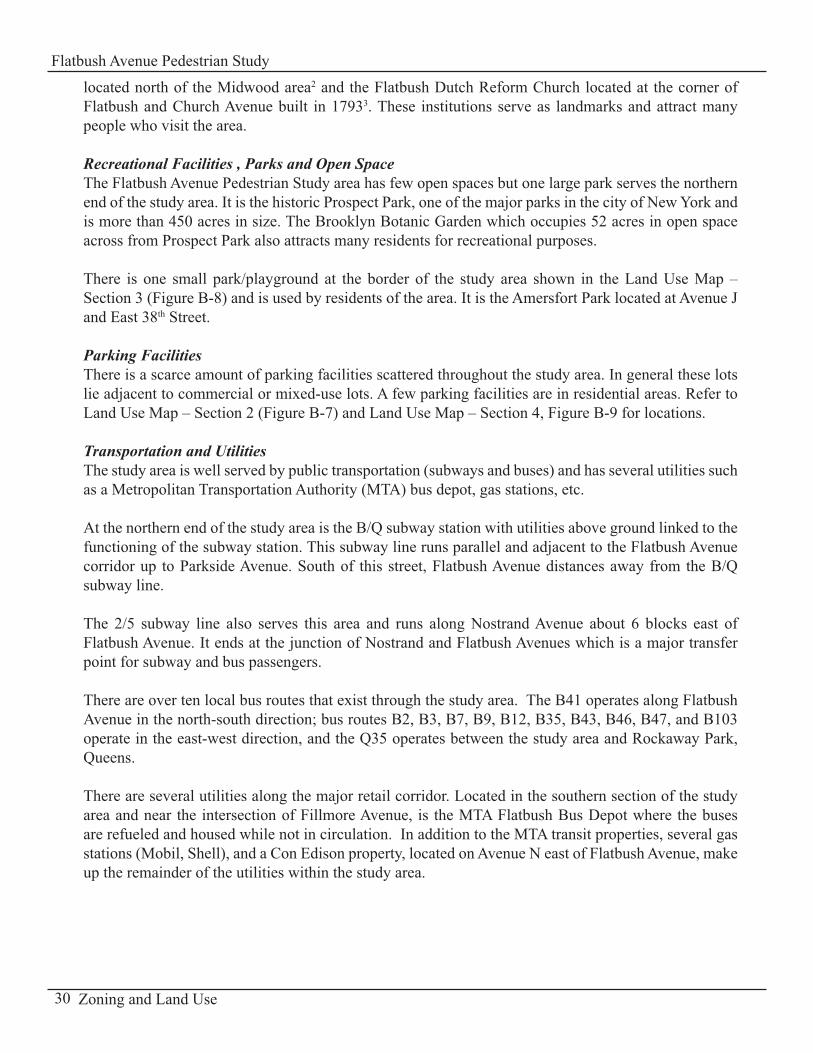
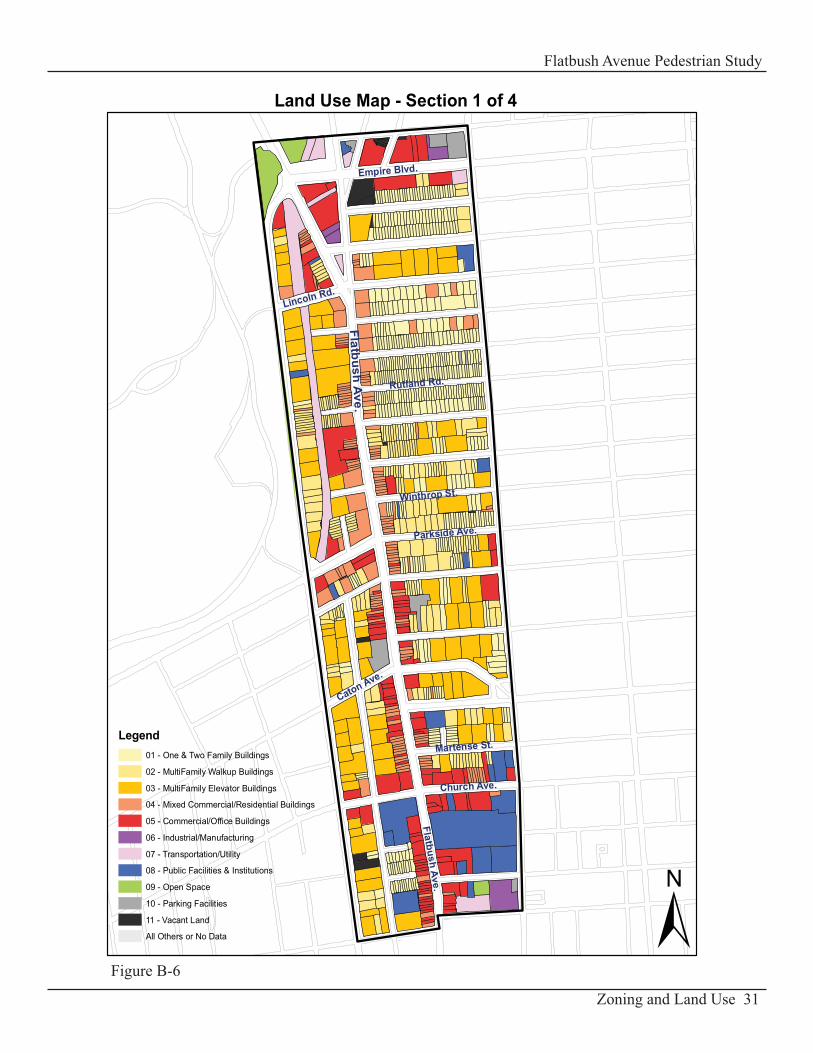
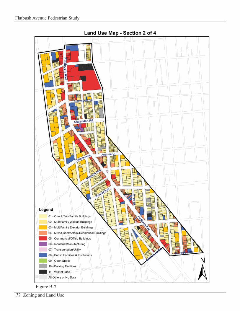
Figure B-1 represents the study area, a large area that has been divided into four sections in this report to better understand the zoning and land use configurations within the area of study. Section 1 stretches along Flatbush Avenue from Empire Boulevard to Albermarle Road, Section 2 from Albermarle Road to Glenwood Road, Section 3 from Glenwood Road to Flatlands Avenue and Section 4 from Flatlands Avenue to Avenue V.
19Zoning and Land Use
Flatbush Avenue Pedestrian Study
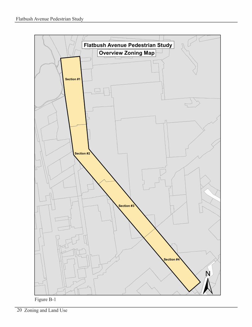
Flatbush Avenue Pedestrian StudyOverview Zoning Map
±
Section #1
Section #2
Section #3
Section #4
20 Zoning and Land Use
Flatbush Avenue Pedestrian Study
Figure B-1
Residential Zoning Districts:There are six residential zoning districts ranging from R2 to R7-1.
R2 DistrictThe R2 district is bounded by Lincoln Road to the north, Fillmore Street to the south, Bedford Avenue to the east and Flatbush Avenue to the west (see Zoning Map - Section 1, Figure B-2).
In R2 districts, residential development is limited to single-family detached houses.
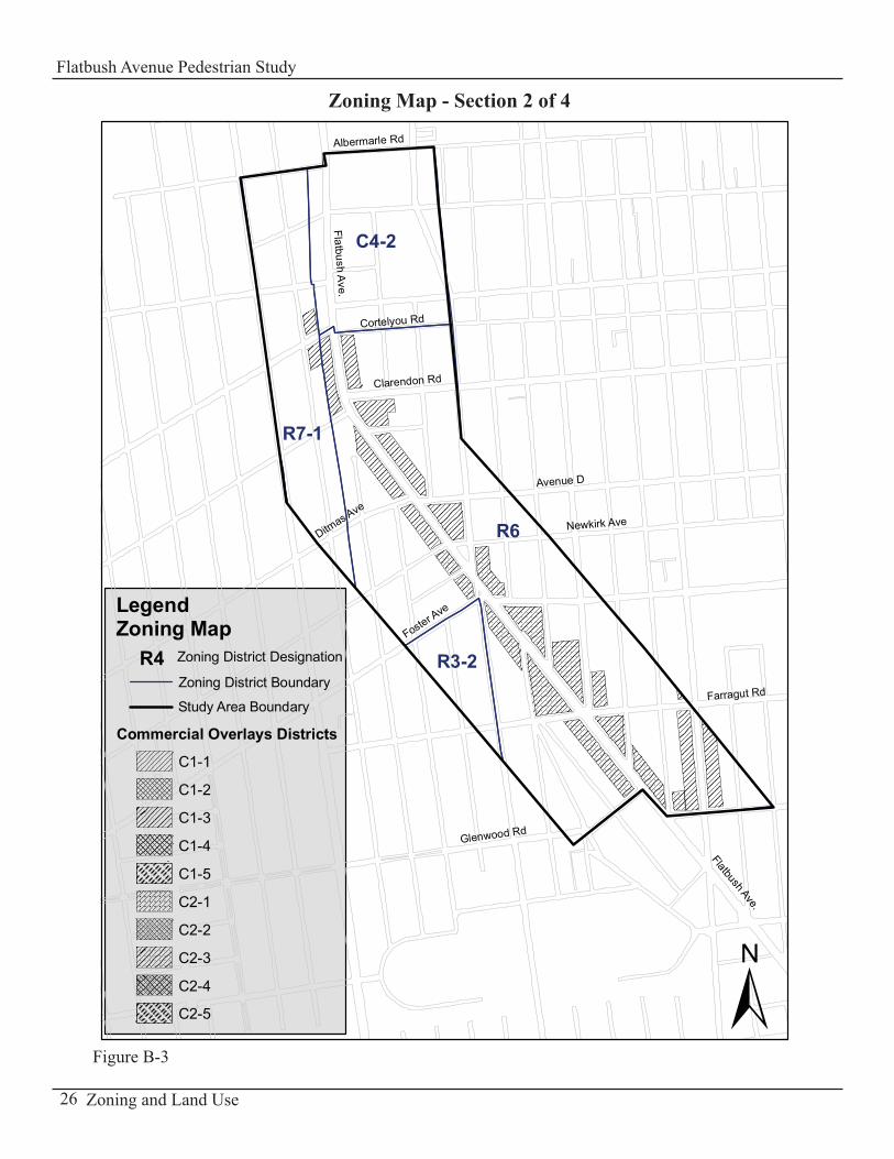
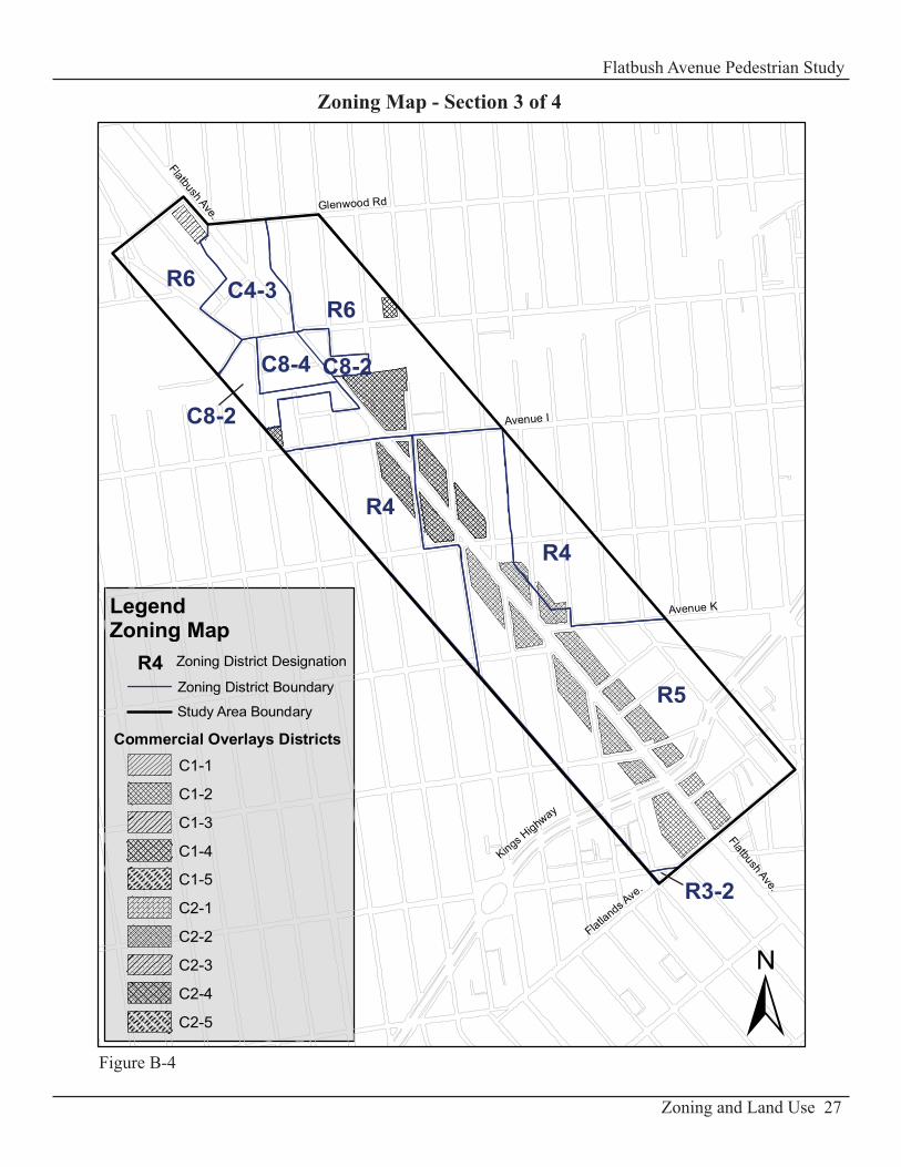
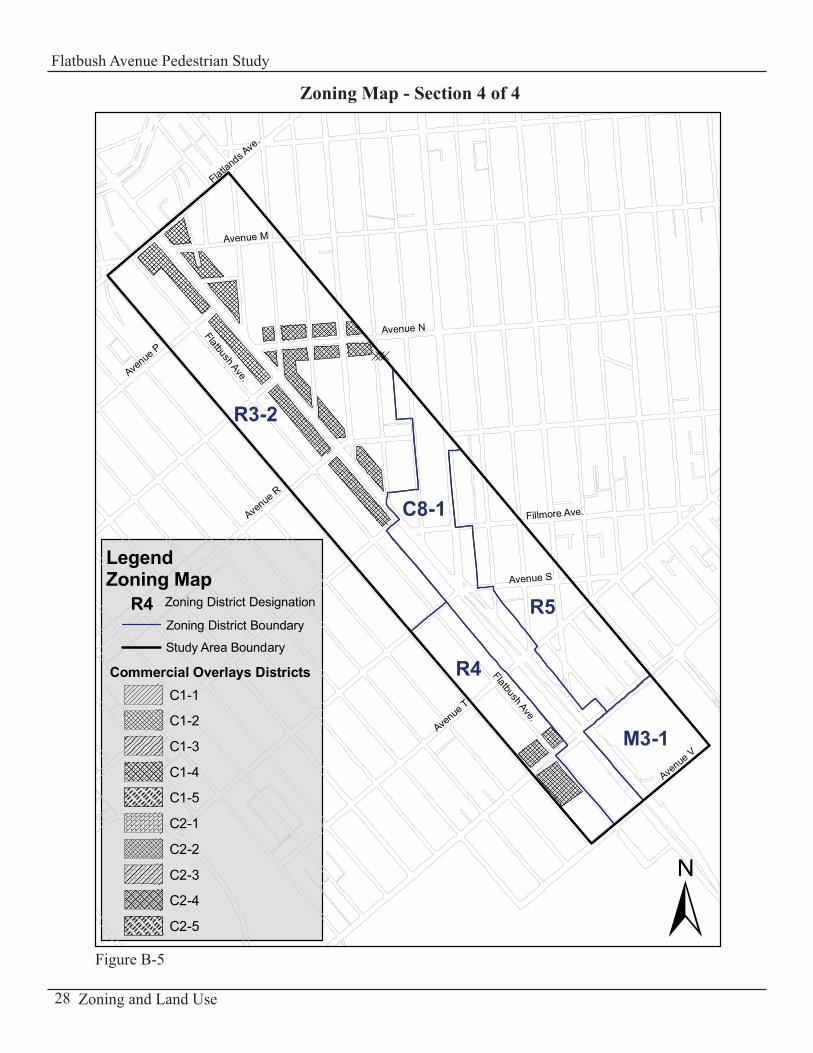
R3-2 DistrictOne of the three areas zoned R3-2 is generally bordered by Foster Avenue to the north, Bedford Avenue to the east and the study area boundary to the west (see Zoning Map -Section 2, Figure B-3). The other R3-2 district is located at the southern end of the study area and is bounded generally by Flatlands Avenue to the north, Avenue S to the south, East 49th Street to the east and Coleman Street to the west (see Zoning Map - Section 4, Figure B-5). Finally, there is a small triangular block just north of Flatlands Avenue and east of East 38th Street which is also zoned R3-2 (see Zoning Map - Section 3, Figure B-4).
R3-2 districts are residential districts that allow a variety of housing types, including low-rise attached houses, small multi-family apartment houses, detached and semi-detached one- and two-family residences.
R4 DistrictThere are three separate R4 districts located within the study area. The first site is bounded by Avenue I to the north, East 35th Street to the east and the study area boundary to the west. The second site is bounded generally by East 36th Street to the west and Avenue K to the south (see Zoning Map - Section 3, Figure B-4). The third R4 district in the study area is bounded by Avenue S to the north, Avenue V to the south, Coleman Street to the west and Flatbush Avenue to the east (see Zoning Map - Section 4, Figure B-5).
R4 districts are residential zones that permit for a variety of housing types including single- and two-family residences that are detached or semi-detached, row houses, and garden apartments. The buildings are usually three stories high.
R5 DistrictThe R5 district is another residential district which exists within the study area. The first R5 district is limited to the north by Empire Boulevard, to the south by Lincoln Road, to the west by Flatbush Avenue and to the east by Bedford (see Zoning Map – Section 1, Figure B-2). The second R5 district is generally bounded by Avenue I to the north, Flatlands Avenue to the south, and by the study area boundary to the west and east (see Zoning Map - Section 3, Figure B-4). The third R5 district in the study area is generally limited to the north by Utica Avenue, to the south by Avenue U, to the west by Flatbush Avenue and to the east by the study area boundary (see Zoning Map – Section 4, Figure B-5).
R5 districts allows for the development of three story attached houses and small apartment houses.
21Zoning and Land Use
Flatbush Avenue Pedestrian Study
R6 DistrictThere are five areas within the study area zoned R6. The first R6 district is adjacent to Prospect Park and located north of Empire Boulevard. The second R6 district area is limited to the north by Fenimore Street, to the south by Clarkson Avenue, to the west by Flatbush Avenue and to the east by Bedford Avenue. In addition there is a very small R6 area just north of Church Avenue and east of Bedford Avenue (see Zoning Map - Section 1, Figure B-2). The third R6 district, which is a large area in the middle of the study area, is generally bounded to the north by Cortelyou Road, to the south by Glenwood Road, to the west by East 21st Street/Foster Avenue/Bedford Avenue and to the east by the study area boundary (see Zoning Map - Section 2, Figure B-3). The last two R6 zoning districts are generally bounded to the north by Glenwood Road and to the south by Avenue I. They are separated in the middle by Flatbush Avenue and several commercial districts (see Zoning Map - Section 3, Figure B-4).
R6 districts encourage small apartment buildings on small lots and tall narrow buildings on larger lots. Heights of tall buildings can range from seven to thirteen-story apartment houses.
R7-1 District An elongated R7-1 residential district stretches from north to south from Empire Boulevard to Newkirk Avenue. This area is generally bounded to the west by Ocean Avenue, to the east by Flatbush and Bedford Avenues (see Zoning Map - Section 1 and 2, Figures B-2 and B-3).
R7-1 districts encourage low apartments buildings on smaller zoning lots and on larger lots, taller buildings with low lot coverage. Within R7-1 residential zoning district, parking is required for 60% of the dwelling units but can be waived if five or fewer spaces are required.
Commercial Zoning Districts:There are five commercial zoning districts within the study area ranging from C4-2 to C8-4 and several commercial overlay districts lined up along Flatbush Avenue.
C4-2 and C4-3 DistrictsThe C4-2 district in the study area is limited by Martense Street to the north, Cortelyou Road to the south, East 21st Street to the west and Bedford Avenue to the east (see Zoning Map - Section 1, Figure B-2).
The C4-3 district located further south is bordered to the north by Glenwood Road, to the south by Avenue H and extends midblock east and west of Flatbush Avenue (see Zoning Map - Section 3, Figure B-4).
In general C4 districts are mapped in regional commercial centers outside of the central business districts. This district allows for specialty and department stores, theaters, and other commercial and office uses that serve a larger area and generate more traffic than the typical neighborhood shopping area. It also permits residential development of a R6 district.
22 Zoning and Land Use
Flatbush Avenue Pedestrian Study
C8-1, C8-2 and C8-4 DistrictsThere are three C8 zoning districts located in the study area: C8-1, C8-2 and C8-4 districts.
The C8-1 district extends generally from Avenue R to Avenue V along Flatbush Avenue (see Zoning Map - Section 4, Figure B-5). The C8-2 districts occupy small sections of the study area. The first C8-2 district is located near Prospect Park and is bounded to the north by Sullivan Avenue, to the south by Sterling Street, to the west by Flatbush Avenue and to the east by Bedford Avenue. The second C8-2 district is limited to the north by Church Avenue, to the south by Albermarle Road and stretches along Bedford Avenue (see Zoning Map - Section 1, Figure B-2). The last two C8-2 districts lie generally between Avenue H and Avenue I and are separated by Flatbush Avenue and the only C8-4 commercial district in the study area (see Zoning Map - Section 3, Figure B-4).
C8 districts permit automotive and heavy commercial services that often require large amounts of land. Typically mapped along major traffic arteries, allowable uses include automobile showrooms, gas stations, and car washes. Housing is not permitted within these districts.
The allowable uses are similar among all C8 districts however the maximum floor area ratio and parking requirements are determined by the difference in the numerical suffix. Automotive uses in C8-1 to C8-3 districts require substantial parking while C8-4 districts are usually exempt from parking requirements.
Commercial Overlay DistrictsThe commercial overlay districts within the study area are aligned along Flatbush Avenue grouped in four clustered areas: a) between Sterling Street and Church Avenue, b) between Cortelyou Road and Glenwood Road,c) between Avenue H and Fillmore Avenue, d) just north and south of Avenue U on the west side of Flatbush Avenue
Refer to Zoning Map Sections 1 – 4 (Figures B-2 through B-5) at the beginning of Part B for the location of the commercial overlay districts.
There are a total of ten designated commercial overlay districts mapped along Flatbush Avenue: C1-1, C1-2, C1-3, C1-4, C1-5, C2-1, C2-2, C2-3, C2-4, and C2-5. They permit retail uses that cater to the daily needs of the immediate and local neighborhood. These uses include grocery stores, small dry cleaners, and local clothing stores. However C2 overlay districts permit a wider range of uses including funeral homes and local repair shops than C1 districts. For both C1 and C2 overlay districts, in mixed residential/commercial buildings, commercial uses are limited to one or two floors and must always be located below the residential use.
23Zoning and Land Use
Flatbush Avenue Pedestrian Study

Manufacturing Zoning Districts:The only manufacturing district M3-1 is located at the southernmost part of the study area. This area is bordered by Avenue U to the north, Avenue V to the south, Flatbush Avenue to the west and by the study area boundary to the east (see Zoning Map - Section 4, Figure B-5).
M3 districts are for heavy industries that generate noise, traffic or pollutants. Typical uses include power plants, solid waste transfer facilities and recycling plants, and fuel supply depots. M3 districts are usually located near the waterfront and buffered from residential areas.
24 Zoning and Land Use
Flatbush Avenue Pedestrian Study
25Zoning and Land Use
Flatbush Avenue Pedestrian Study
Figure B-2
R7-1
R2
R6
R5
C4-2
C8-2R6
C8-2
R6
Park
R6
±
Flatbush Ave.
Albermarle Rd
Empire Blvd
Ocean Ave
Zoning District Boundary
Study Area Boundary
Commercial Overlays Districts
Zoning District DesignationR4
Parkside Ave
Lincoln Rd
Fenimore St
LegendZoning Map
C1-1
C1-2
C1-3
C1-4
C1-5
C2-1
C2-2
C2-3
C2-4
C2-5
Flatbush Ave.
Lenox Rd
Church Ave
Caton Ave
Zoning Map - Section 1 of 4
26 Zoning and Land Use
Flatbush Avenue Pedestrian Study
R6
C4-2
R7-1
R3-2
±
Flatbush Ave.
Clarendon Rd
Glenwood Rd
Albermarle Rd
Ditmas Ave
Foster Ave
Flatbush Ave.
Zoning District Boundary
Study Area Boundary
Commercial Overlays Districts
Zoning District DesignationR4
Cortelyou Rd
LegendZoning Map
C1-1
C1-2
C1-3
C1-4
C1-5
C2-1
C2-2
C2-3
C2-4
C2-5
Farragut Rd
Newkirk Ave
Avenue D
Figure B-3
Zoning Map - Section 2 of 4
27Zoning and Land Use
Flatbush Avenue Pedestrian Study
R5
R6
R4
R4
R6 C4-3
C8-4
C8-2
C8-2
R3-2
±
Flatbush Ave.
Flatland
s Ave
.
Avenue K
Glenwood Rd
Kings Highway
Flatbush Ave.Zoning District Boundary
Study Area Boundary
Commercial Overlays Districts
Zoning District DesignationR4
LegendZoning Map
C1-1
C1-2
C1-3
C1-4
C1-5
C2-1
C2-2
C2-3
C2-4
C2-5
Avenue I
Figure B-4
Zoning Map - Section 3 of 4
28 Zoning and Land Use
Flatbush Avenue Pedestrian Study
Figure B-5
R3-2
R5
C8-1
R4
M3-1
±
Avenue
P
Flatbush Ave.
Avenue
T
Flatland
s Ave
.
Fillmore Ave.
Avenue M
Avenue N
Avenue S
Avenue
V
Avenue
R
Flatbush Ave.LegendZoning Map
C1-1
C1-2
C1-3
C1-4
C1-5
C2-1
C2-2
C2-3
C2-4
C2-5
Zoning District Boundary
Study Area Boundary
Commercial Overlays Districts
Zoning District DesignationR4
Zoning Map - Section 4 of 4
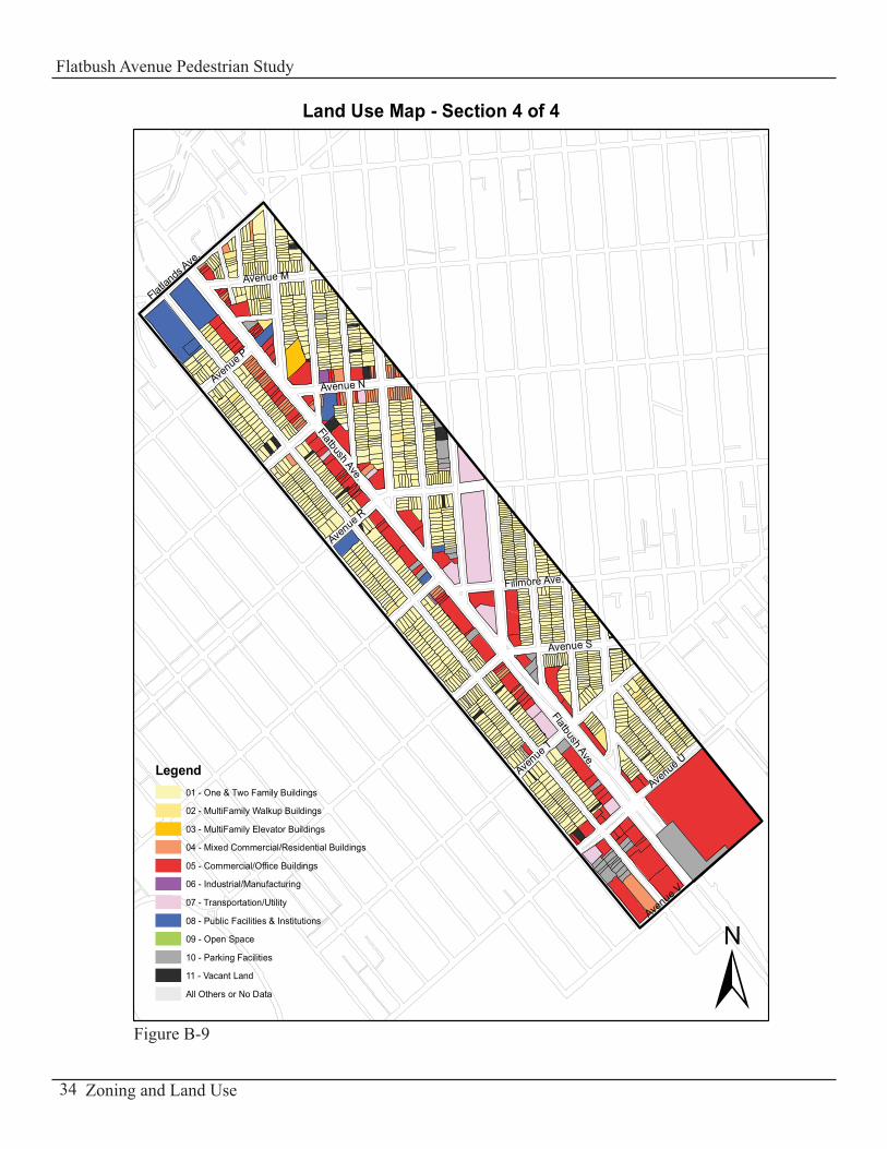
Land Use The study area is predominantly residential (70% of the study area) with commercial activities and businesses along the Flatbush Avenue corridor.
Residential UseThe residential area is made up of 47% of one- and two-family houses, which occupies close to half the residential lots in the study area, while 38% of multi-family walkup and elevator buildings exists within the study area boundaries.
From Empire Boulevard to Newkirk Avenue, the area consists of multi-family residential buildings primarily west of Flatbush Avenue and of one-and two-family houses located east of the major retail corridor. Many of the residences are brick and stone one- and two- family houses particularly in the historic district of Lefferts Gardens (see Land Use Map – Section 1 and 2, Figures B-6 and B-7). Secondly, at the southern end of the study area from Avenue I to Avenue U, the housing stock is comprised of one- and two- family detached and semi-detached houses (see Land Use Map – Section 3 and 4, Figures B-8 and B-9). Third, a sizeable number of multi-family residential buildings are concentrated in the middle of the study area between Newkirk Avenue and Avenue I (see Land Use Map – Section 2 and 3, Figures B-7 and B-8).
Aligned along the Flatbush Avenue corridor are mixed commercial and residential buildings with residential units above businesses and retail stores. They represent 15% of the residential area.
Commercial UseFlatbush Avenue is a major transportation route and is a central shopping and commercial area that serves the needs of the residents within the Flatbush Avenue Pedestrian Study area. Many of the structures on both sides of Flatbush Avenue are two- to three-story mixed-use commercial/residential buildings with retail on the ground floor and residential or office/business space above. These mixed use buildings represent 8% of the study area.
Along the Flatbush Avenue corridor, there are several franchise restaurants such as McDonald’s, Wendy’s, Golden Krust, DeIslands and local eateries that serve the many ethnic groups that live in the study area. In addition, there are major financial centers (Chase, Citibank, Flatbush Federal Savings Bank, etc), chain pharmacies (Rite Aid, Walgreens), medical clinics and small family owned businesses in this busy commercial area. Located at the southern most point of the study area is the recently renovated Kings Plaza Shopping Mall Center that serves as a “one stop shop” location for goods, services, and entertainment.
The retail chain store “Target” recently opened on Flatbush Avenue at Avenue H on what used to be an underutilized municipal parking lot. It is a new addition to the already busy commercial area and is expected to boost economic revenue in the area.
Public Facilities & InstitutionsThere are few public facilities or institutions and are dispersed throughout the study area. However there are a few with notable historical significance for Brooklyn. They include: Erasmus Hall High School, whose buildings were erected between 1905 and 1940 and are arranged around an open quadrangle with the original school building in the middle1; the Brooklyn College Campus built in the 1930’s is
29Zoning and Land Use
Flatbush Avenue Pedestrian Study
located north of the Midwood area2 and the Flatbush Dutch Reform Church located at the corner of Flatbush and Church Avenue built in 17933. These institutions serve as landmarks and attract many people who visit the area.
Recreational Facilities , Parks and Open SpaceThe Flatbush Avenue Pedestrian Study area has few open spaces but one large park serves the northern end of the study area. It is the historic Prospect Park, one of the major parks in the city of New York and is more than 450 acres in size. The Brooklyn Botanic Garden which occupies 52 acres in open space across from Prospect Park also attracts many residents for recreational purposes.
There is one small park/playground at the border of the study area shown in the Land Use Map – Section 3 (Figure B-8) and is used by residents of the area. It is the Amersfort Park located at Avenue J and East 38th Street.
Parking Facilities There is a scarce amount of parking facilities scattered throughout the study area. In general these lots lie adjacent to commercial or mixed-use lots. A few parking facilities are in residential areas. Refer to Land Use Map – Section 2 (Figure B-7) and Land Use Map – Section 4, Figure B-9 for locations.
Transportation and UtilitiesThe study area is well served by public transportation (subways and buses) and has several utilities such as a Metropolitan Transportation Authority (MTA) bus depot, gas stations, etc.
At the northern end of the study area is the B/Q subway station with utilities above ground linked to the functioning of the subway station. This subway line runs parallel and adjacent to the Flatbush Avenue corridor up to Parkside Avenue. South of this street, Flatbush Avenue distances away from the B/Q subway line.
The 2/5 subway line also serves this area and runs along Nostrand Avenue about 6 blocks east of Flatbush Avenue. It ends at the junction of Nostrand and Flatbush Avenues which is a major transfer point for subway and bus passengers.
There are over ten local bus routes that exist through the study area. The B41 operates along Flatbush Avenue in the north-south direction; bus routes B2, B3, B7, B9, B12, B35, B43, B46, B47, and B103 operate in the east-west direction, and the Q35 operates between the study area and Rockaway Park, Queens.
There are several utilities along the major retail corridor. Located in the southern section of the study area and near the intersection of Fillmore Avenue, is the MTA Flatbush Bus Depot where the buses are refueled and housed while not in circulation. In addition to the MTA transit properties, several gas stations (Mobil, Shell), and a Con Edison property, located on Avenue N east of Flatbush Avenue, make up the remainder of the utilities within the study area.
30 Zoning and Land Use
Flatbush Avenue Pedestrian Study
31Zoning and Land Use
Flatbush Avenue Pedestrian Study
Land Use Map - Section 1 of 4
±
Flatbush Ave.
Empire Blvd.
Parkside Ave.
Winthrop St.
Martense St.
Church Ave.
Legend01 - One & Two Family Buildings
02 - MultiFamily Walkup Buildings
03 - MultiFamily Elevator Buildings
04 - Mixed Commercial/Residential Buildings
05 - Commercial/Office Buildings
06 - Industrial/Manufacturing
07 - Transportation/Utility
08 - Public Facilities & Institutions
09 - Open Space
10 - Parking Facilities
11 - Vacant Land
All Others or No Data
Lincoln Rd.
Rutland Rd.
Caton Ave.
Flatbush Ave.
Figure B-6
32 Zoning and Land Use
Flatbush Avenue Pedestrian Study
Land Use Map - Section 2 of 4
±
Flatbush Ave.
Clarendon Rd.
Newkirk Ave.
Ditmas Ave.
E. 26 St.
Glenwood Rd.
Cortelyou Rd.
Avenue D
Foster Ave.
Flatbush Ave.
Glenwood Rd.
Legend01 - One & Two Family Buildings
02 - MultiFamily Walkup Buildings
03 - MultiFamily Elevator Buildings
04 - Mixed Commercial/Residential Buildings
05 - Commercial/Office Buildings
06 - Industrial/Manufacturing
07 - Transportation/Utility
08 - Public Facilities & Institutions
09 - Open Space
10 - Parking Facilities
11 - Vacant Land
All Others or No Data
Figure B-7
33Zoning and Land Use
Flatbush Avenue Pedestrian Study
±Flatla
nds Ave
.
Kings Highway
Land Use Map - Section 3 of 4
Flatbush Ave.
Flatbush Ave.
Avenue I
Avenue K
Avenue J
Legend01 - One & Two Family Buildings
02 - MultiFamily Walkup Buildings
03 - MultiFamily Elevator Buildings
04 - Mixed Commercial/Residential Buildings
05 - Commercial/Office Buildings
06 - Industrial/Manufacturing
07 - Transportation/Utility
08 - Public Facilities & Institutions
09 - Open Space
10 - Parking Facilities
11 - Vacant Land
All Others or No Data
Avenue H
Glenwood Rd.
Glenwood Rd.
Nostrand Ave.
Figure B-8
34 Zoning and Land Use
Flatbush Avenue Pedestrian Study
±Ave
nue V
Avenue T
Avenue M
Land Use Map - Section 4 of 4
Avenue P
Flatbush Ave.
Flatbush Ave.
Avenue N
Avenue R
Flatlands
Ave.
Avenue S
Fillmore Ave.
Legend01 - One & Two Family Buildings
02 - MultiFamily Walkup Buildings
03 - MultiFamily Elevator Buildings
04 - Mixed Commercial/Residential Buildings
05 - Commercial/Office Buildings
06 - Industrial/Manufacturing
07 - Transportation/Utility
08 - Public Facilities & Institutions
09 - Open Space
10 - Parking Facilities
11 - Vacant Land
All Others or No Data
Avenue U
Figure B-9

35Zoning and Land Use
Flatbush Avenue Pedestrian Study

36 Study Locations Analysis
Flatbush Avenue Pedestrian Study
37Study Locations Analysis
Flatbush Avenue Pedestrian Study
Part C Study Locations Analysis

38 Study Locations Analysis
Flatbush Avenue Pedestrian Study
A total of thirty three (33) locations were selected along Flatbush Avenue for study and analysis in terms of pedestrian safety, mobility, and circulation. The selection criteria for these locations were as follows:
if five or more pedestrian accidents had occurred from 2004 -2006,• if they presented any safety issues for pedestrians,• and/ or demonstrated problematic trends or opportunities for improvement in terms of • pedestrians.
The locations are categorized into three groups: major, secondary and other study locations. The major study locations compared to the secondary study locations had unique conditions along the corridor that required a more detailed analysis in terms of pedestrian traffic, vehicular traffic and the level of service.
The major study locations are:Flatbush Avenue and Church Avenue• Flatbush Avenue and Foster/ Bedford Avenue• Flatbush Avenue and Avenue U• Flatbush Avenue between Avenue U and Avenue V•
The secondary study locations are:Flatbush Avenue and Empire Boulevard/ Ocean Avenue• Flatbush Avenue and Winthrop Street • Flatbush Avenue and Parkside Avenue • Flatbush Avenue and Martense Street • Flatbush Avenue and Cortelyou Road• Flatbush Avenue and Clarendon / Dorchester Road• Flatbush Avenue and Avenue D/ Ditmas Avenue• Flatbush Avenue and Newkirk Avenue • Flatbush Avenue and Glenwood Road • Flatbush Avenue and Nostrand Avenue/ Hillel Place• Flatbush Avenue and Avenue H • Flatbush Avenue and Kings Highway • Flatbush Avenue and Utica Avenue •
An additional group of 16 other locations were studied and analyzed where one-way streets intersect Flatbush Avenue at an angle. At these intersections pedestrians crossing are not always visible to motorists due to the geometry of the intersection. Here is a listing of the other study locations:
E 26th Street (SB traffic – west of Flatbush Ave.)• E 26th Street (NB traffic – east of Flatbush Ave.)• E 31• st Street (NB traffic – east of Flatbush Ave.)Aurelia Court (WB traffic – east of Flatbush Ave.) • E 34• th Street – (SB traffic - west of Flatbush Ave)Brooklyn Ave (NB traffic – east of Flatbush Ave.)• E 36• th Street (SB traffic – west of Flatbush Ave.) E 38• th Street (SB traffic - west of Flatbush Ave.)Hubbard Place (EB traffic - east of Flatbush Ave.)• Alton Place (EB traffic - east of Flatbush Ave.)•
39Study Locations Analysis
Flatbush Avenue Pedestrian Study
Lott Place (EB traffic- east of Flatbush Ave.)• Baughman Pl (EB traffic - east of Flatbush Ave)• Schenectady Avenue (NB traffic – east of Flatbush Ave.)• E 48• th Street (NB traffic – east of Flatbush Ave.)E 51• st Street (NB traffic – east of Flatbush Ave.)E 53• rd Street (NB traffic, east of Flatbush Ave.)
40 Study Locations Analysis
Flatbush Avenue Pedestrian Study
41Study Locations Analysis
Flatbush Avenue Pedestrian Study
Major Study Locations
- Flatbush Avenue and Church Avenue- Flatbush Avenue and Foster/ Bedford Avenue- Flatbush Avenue and Avenue U- Flatbush Avenue between Avenue U and Avenue V

42 Study Locations Analysis
Flatbush Avenue Pedestrian Study
43Study Locations Analysis
Flatbush Avenue Pedestrian Study
Flatbush Ave. & Church Ave.
Flatbush Ave.
Church Ave.
Church Ave.
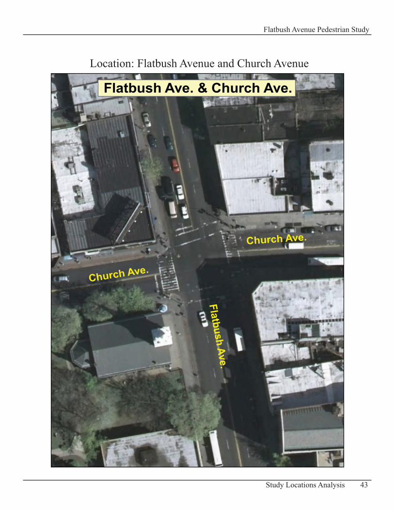
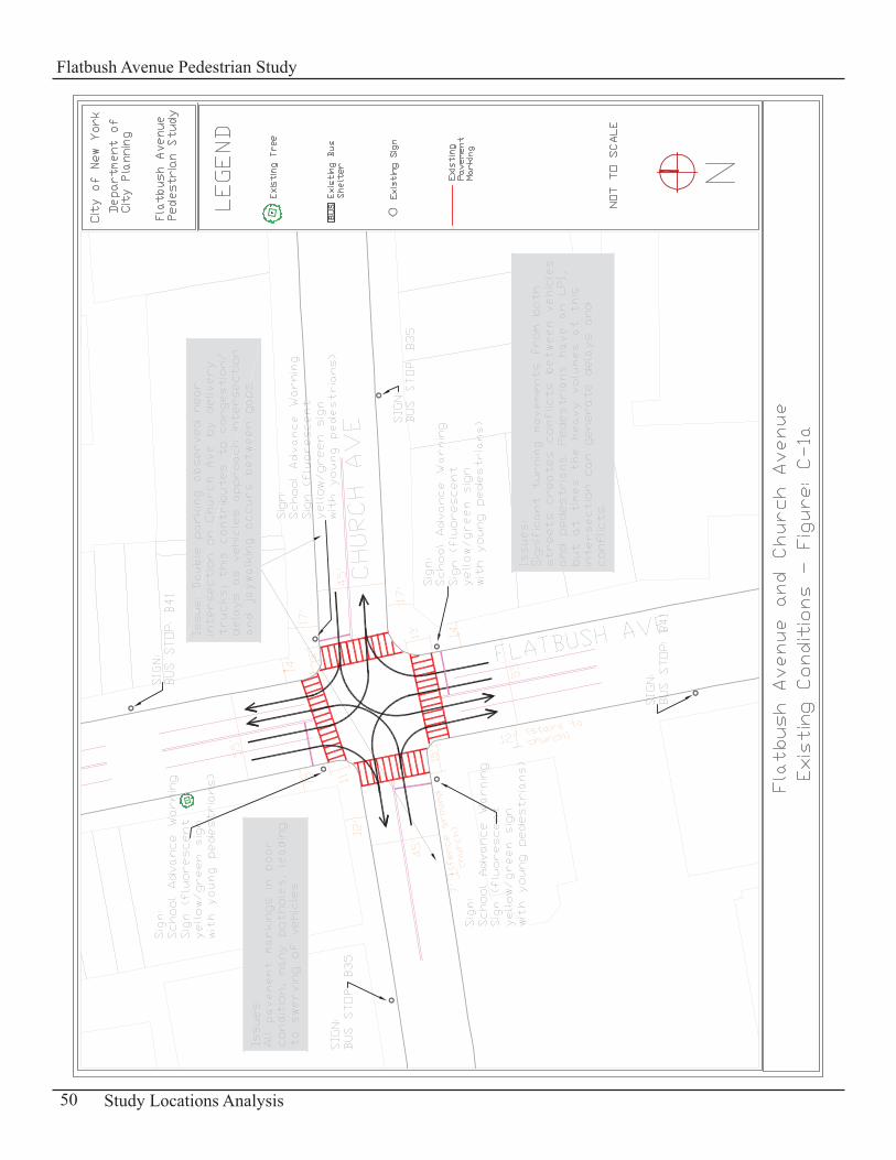
Location: Flatbush Avenue and Church Avenue
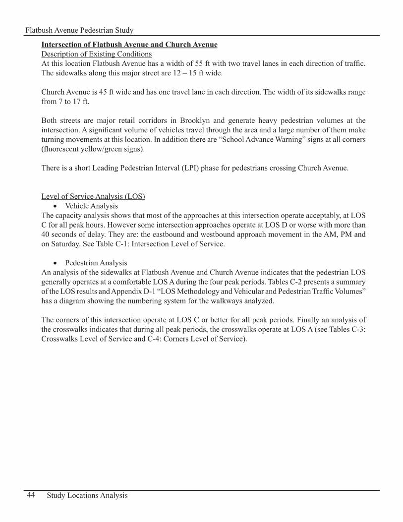
Intersection of Flatbush Avenue and Church AvenueDescription of Existing ConditionsAt this location Flatbush Avenue has a width of 55 ft with two travel lanes in each direction of traffic. The sidewalks along this major street are 12 – 15 ft wide.
Church Avenue is 45 ft wide and has one travel lane in each direction. The width of its sidewalks range from 7 to 17 ft.
Both streets are major retail corridors in Brooklyn and generate heavy pedestrian volumes at the intersection. A significant volume of vehicles travel through the area and a large number of them make turning movements at this location. In addition there are “School Advance Warning” signs at all corners (fluorescent yellow/green signs).
There is a short Leading Pedestrian Interval (LPI) phase for pedestrians crossing Church Avenue.
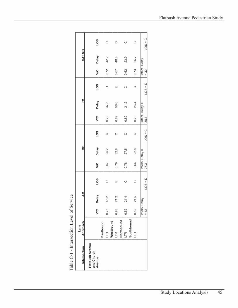
Level of Service Analysis (LOS)Vehicle Analysis•
The capacity analysis shows that most of the approaches at this intersection operate acceptably, at LOS C for all peak hours. However some intersection approaches operate at LOS D or worse with more than 40 seconds of delay. They are: the eastbound and westbound approach movement in the AM, PM and on Saturday. See Table C-1: Intersection Level of Service.
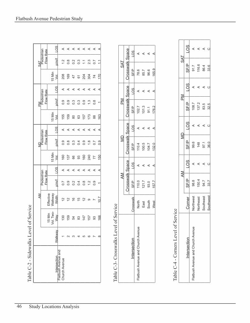
Pedestrian Analysis• An analysis of the sidewalks at Flatbush Avenue and Church Avenue indicates that the pedestrian LOS generally operates at a comfortable LOS A during the four peak periods. Tables C-2 presents a summary of the LOS results and Appendix D-1 “LOS Methodology and Vehicular and Pedestrian Traffic Volumes” has a diagram showing the numbering system for the walkways analyzed.
The corners of this intersection operate at LOS C or better for all peak periods. Finally an analysis of the crosswalks indicates that during all peak periods, the crosswalks operate at LOS A (see Tables C-3: Crosswalks Level of Service and C-4: Corners Level of Service).
44 Study Locations Analysis
Flatbush Avenue Pedestrian Study
Inte
rsec
tion
Lane
A
ppro
ach
AM
MD
PMSA
T M
D
Flat
bush
Ave
nue
and
Chu
rch
Aven
ue
V/C
Del
ayLO
SV/
CD
elay
LOS
V/C
Del
ayLO
SV/
CD
elay
LOS
Ea
stbo
und
LT
R0.
7848
.2D
0.57
25.2
C0.
7947
.8D
0.72
42.2
D
Wes
tbou
nd
LTR
0.98
71.2
E0.
7932
.8C
0.89
56.6
E0.
6740
.8D
N
orth
boun
d
LTR
0.52
21.4
C0.
7827
.5C
0.80
31.2
C0.
6223
.9C
So
uthb
ound
LT
R0.
5221
.5C
0.64
22.8
C0.
7026
.4C
0.73
26.7
C
Inte
rs. D
elay
=
42LO
S =
DIn
ters
. Del
ay =
27
.3LO
S =
CIn
ters
. Del
ay =
38
.7LO
S =
DIn
ters
. Del
ay
= 32
LOS
= C
45Study Locations Analysis
Flatbush Avenue Pedestrian Study
Tabl
e C
-1 -
Inte
rsec
tion
Leve
l of S
ervi
ce
Inte
rsec
tion
Wal
kway
AM
MD
PM
SAT
15 M
in
Vol.
Two-
Way
Effe
ctiv
e W
alkw
ay
Wid
th
Ped
estri
an
Flow
Rat
e
15 M
in
Vol.
Ped
estri
an
Flow
Rat
e
15 M
in
Vol.
Ped
estri
an
Flow
Rat
e
15 M
in
Vol.
Ped
estri
an
Flow
Rat
e
p/m
/fLO
Sp/
m/f
LOS
p/m
/fLO
Sp/
m/f
LOS
Flat
bush
Ave
nue
and
Chu
rch
Aven
ue1
130
120.
7A
160
0.9
A15
50.
9A
208
1.2
A
215
912
0.9
A13
70.
8A
159
0.9
A16
90.
8A
3
5416
0.2
A66
0.3
A80
0.3
A47
0.2
A
483
150.
4A
930.
4A
630.
3A
610.
3A
5
147
120.
8A
160
0.9
A15
70.
9A
204
1.1
A
615
79
1.2
A24
01.
8A
173
1.3
A30
42.
3A
7
937
0.9
A77
0.7
A88
0.8
A74
0.7
A
816
610
.71
A15
00.
9A
163
1A
170
1.1
A
Inte
rsec
tion
Cro
ssw
alk
AM
MD
PM
SAT
Cro
ssw
alk
Spa
ceC
ross
wal
k S
pace
Cro
ssw
alk
Spa
ceC
ross
wal
k S
pace
SF/
PLO
SS
F/P
LOS
SF/
PLO
SS
F/P
LOS
Flat
bush
Ave
nue
and
Chu
rch
Aven
ueN
orth
110.
0A
110.
4A
102.
7A
78.6
A
Eas
t 12
1.7
A10
0.5
A10
1.3
A85
.7A
S
outh
93.0
A10
4.7
A91
.1A
96.6
A
Wes
t15
7.7
A13
2.0
A17
6.2
A16
5.9
A
Inte
rsec
tion
Cor
ner
AM
MD
PM
SAT
SF/
PLO
SS
F/P
LOS
SF/
PLO
SS
F/P
LOS
Flat
bush
Ave
nue
and
Chu
rch
Aven
ueN
orth
wes
t98
.8A
99.6
A10
8.7
A91
.7A
N
orth
east
150.
4A
148
A13
7.2
A11
6.6
A
Sou
thea
st94
.7A
97.1
A83
.5A
86.4
AS
outh
wes
t33
.7C
36.0
C32
.5C
33.6
C
46 Study Locations Analysis
Flatbush Avenue Pedestrian Study
Tabl
e C
-2 -
Side
wal
ks L
evel
of S
ervi
ce
Tabl
e C
-4 -
Cor
ners
Lev
el o
f Ser
vice
Tabl
e C
-3- C
ross
wal
ks L
evel
of S
ervi
ce
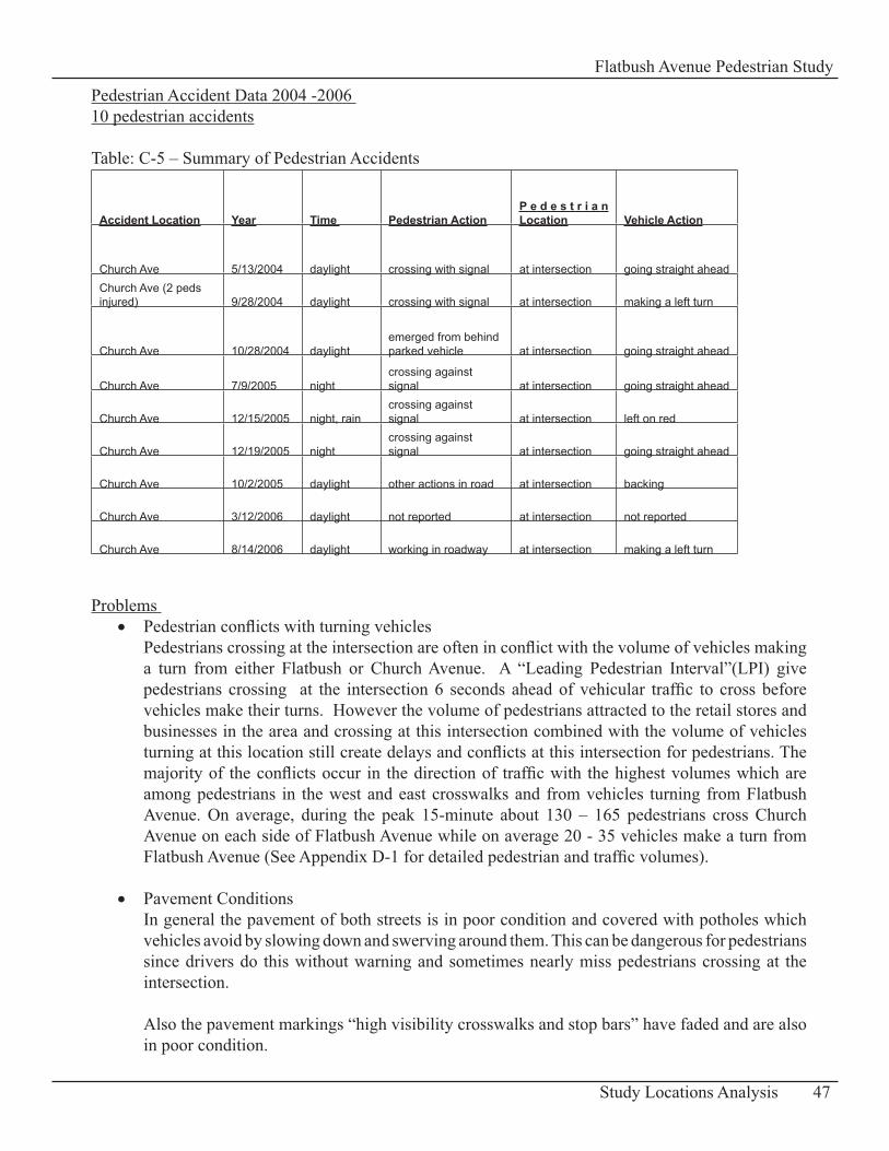
Pedestrian Accident Data 2004 -2006 10 pedestrian accidents
Table: C-5 – Summary of Pedestrian Accidents
Accident Location Year Time Pedestrian ActionP e d e s t r i a n Location Vehicle Action
Church Ave 5/13/2004 daylight crossing with signal at intersection going straight aheadChurch Ave (2 peds injured) 9/28/2004 daylight crossing with signal at intersection making a left turn
Church Ave 10/28/2004 daylightemerged from behind parked vehicle at intersection going straight ahead
Church Ave 7/9/2005 nightcrossing against signal at intersection going straight ahead
Church Ave 12/15/2005 night, raincrossing against signal at intersection left on red
Church Ave 12/19/2005 nightcrossing against signal at intersection going straight ahead
Church Ave 10/2/2005 daylight other actions in road at intersection backing
Church Ave 3/12/2006 daylight not reported at intersection not reported
Church Ave 8/14/2006 daylight working in roadway at intersection making a left turn
Problems Pedestrian conflicts with turning vehicles• Pedestrians crossing at the intersection are often in conflict with the volume of vehicles making a turn from either Flatbush or Church Avenue. A “Leading Pedestrian Interval”(LPI) give pedestrians crossing at the intersection 6 seconds ahead of vehicular traffic to cross before vehicles make their turns. However the volume of pedestrians attracted to the retail stores and businesses in the area and crossing at this intersection combined with the volume of vehicles turning at this location still create delays and conflicts at this intersection for pedestrians. The majority of the conflicts occur in the direction of traffic with the highest volumes which are among pedestrians in the west and east crosswalks and from vehicles turning from Flatbush Avenue. On average, during the peak 15-minute about 130 – 165 pedestrians cross Church Avenue on each side of Flatbush Avenue while on average 20 - 35 vehicles make a turn from Flatbush Avenue (See Appendix D-1 for detailed pedestrian and traffic volumes).
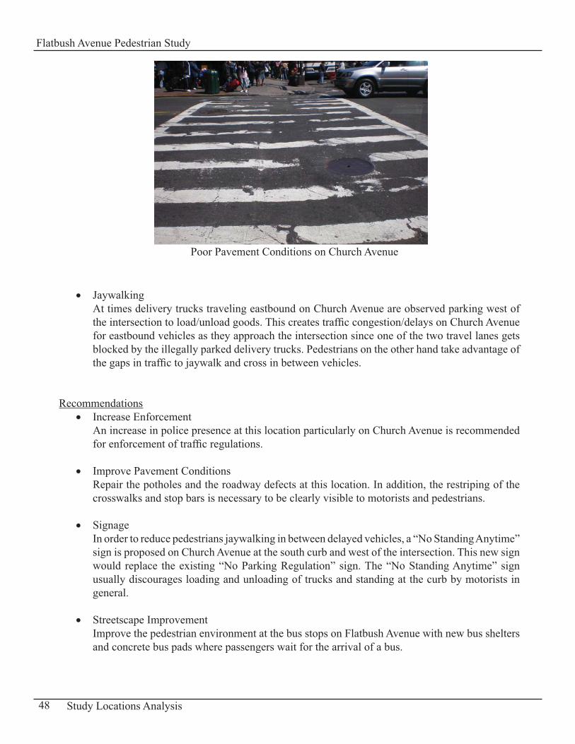
Pavement Conditions• In general the pavement of both streets is in poor condition and covered with potholes which vehicles avoid by slowing down and swerving around them. This can be dangerous for pedestrians since drivers do this without warning and sometimes nearly miss pedestrians crossing at the intersection.
Also the pavement markings “high visibility crosswalks and stop bars” have faded and are also in poor condition.
47Study Locations Analysis
Flatbush Avenue Pedestrian Study
Jaywalking • At times delivery trucks traveling eastbound on Church Avenue are observed parking west of the intersection to load/unload goods. This creates traffic congestion/delays on Church Avenue for eastbound vehicles as they approach the intersection since one of the two travel lanes gets blocked by the illegally parked delivery trucks. Pedestrians on the other hand take advantage of the gaps in traffic to jaywalk and cross in between vehicles.
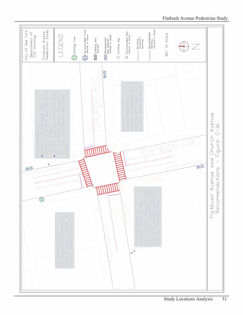
RecommendationsIncrease Enforcement• An increase in police presence at this location particularly on Church Avenue is recommended for enforcement of traffic regulations.
Improve Pavement Conditions• Repair the potholes and the roadway defects at this location. In addition, the restriping of the crosswalks and stop bars is necessary to be clearly visible to motorists and pedestrians.
Signage• In order to reduce pedestrians jaywalking in between delayed vehicles, a “No Standing Anytime” sign is proposed on Church Avenue at the south curb and west of the intersection. This new sign would replace the existing “No Parking Regulation” sign. The “No Standing Anytime” sign usually discourages loading and unloading of trucks and standing at the curb by motorists in general.
Streetscape Improvement• Improve the pedestrian environment at the bus stops on Flatbush Avenue with new bus shelters and concrete bus pads where passengers wait for the arrival of a bus.
48 Study Locations Analysis
Flatbush Avenue Pedestrian Study
Poor Pavement Conditions on Church Avenue
Consideration for the Future Recommendation for a Countdown Pedestrian SignalThe installation of a countdown pedestrian signal is recommended to be considered for Flatbush and Church Avenues to reduce conflicts between pedestrians crossing and vehicles making turns. This type of traffic signal can provide pedestrians with information about the amount of time remaining in a crossing interval and can improve pedestrian signal compliance.
Currently New York City Department of Transportation (NYCDOT) is conducting a study and a pilot program of countdown pedestrian signals at 24 intersections. This pilot program has been expanded and will also take place along selected busy corridors in all five boroughs. This study is to be completed in the fall of 2008 (Source: DOT Press Release on 11/8/07).
49Study Locations Analysis
Flatbush Avenue Pedestrian Study
50 Study Locations Analysis
Flatbush Avenue Pedestrian Study
51Study Locations Analysis
Flatbush Avenue Pedestrian Study

52 Study Locations Analysis
Flatbush Avenue Pedestrian Study
53Study Locations Analysis
Flatbush Avenue Pedestrian Study
Flatbush Ave. & Foster Ave.
Flatbush Ave.
Foster Ave.
Foster Ave.
Bedford Ave.
Bedford Ave.
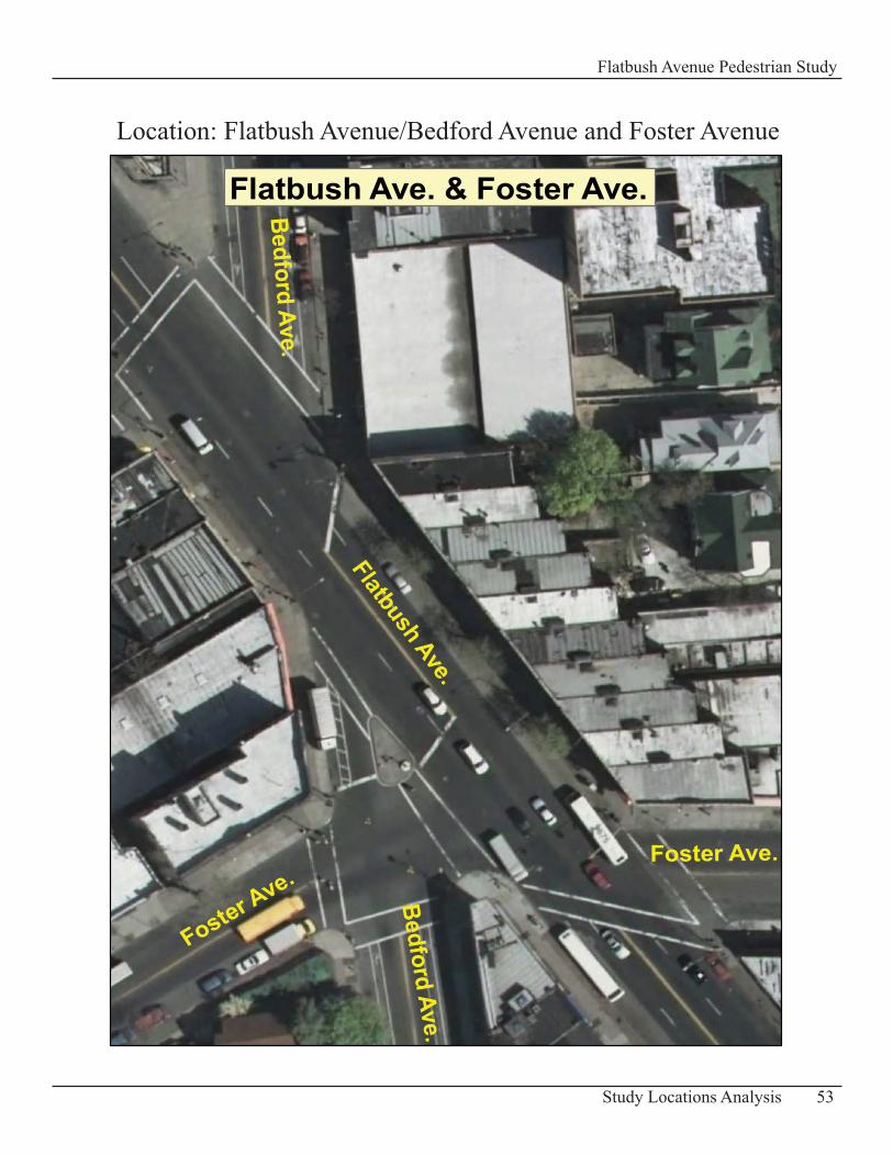
Location: Flatbush Avenue/Bedford Avenue and Foster Avenue
Intersection of Flatbush Avenue and Foster/Bedford AvenueDescription of Existing Conditions Flatbush Avenue intersects at an angle with two main avenues at this location, Foster Avenue and Bedford Avenue, which creates an awkwardly shaped intersection.
Flatbush Avenue has a width of 55 - 60 ft with two travel lanes in each direction of traffic. The sidewalks are approximately 11-14 ft wide in this area.
Foster Avenue is 40-45 ft wide and has one travel lane in each direction. The width of its sidewalks range from 10 to 17 ft.
Bedford Avenue travels north-south and is 45 feet wide. It has one travel lane and a bicycle lane in each direction of traffic.
Flatbush and Bedford Avenues are major traffic corridors in Brooklyn and generate significant vehicular volumes at the intersection (mainly through traffic). A moderate volume of pedestrians travels through this intersection where many pedestrians arrive by bus. This is a common transfer point for bus riders between the B41, B8 and B49.
In addition there are warning signs posted: “School Advance Warning” signs (fluorescent yellow/green sign with young pedestrians).
Level of Service Analysis (LOS)Vehicle Analysis•
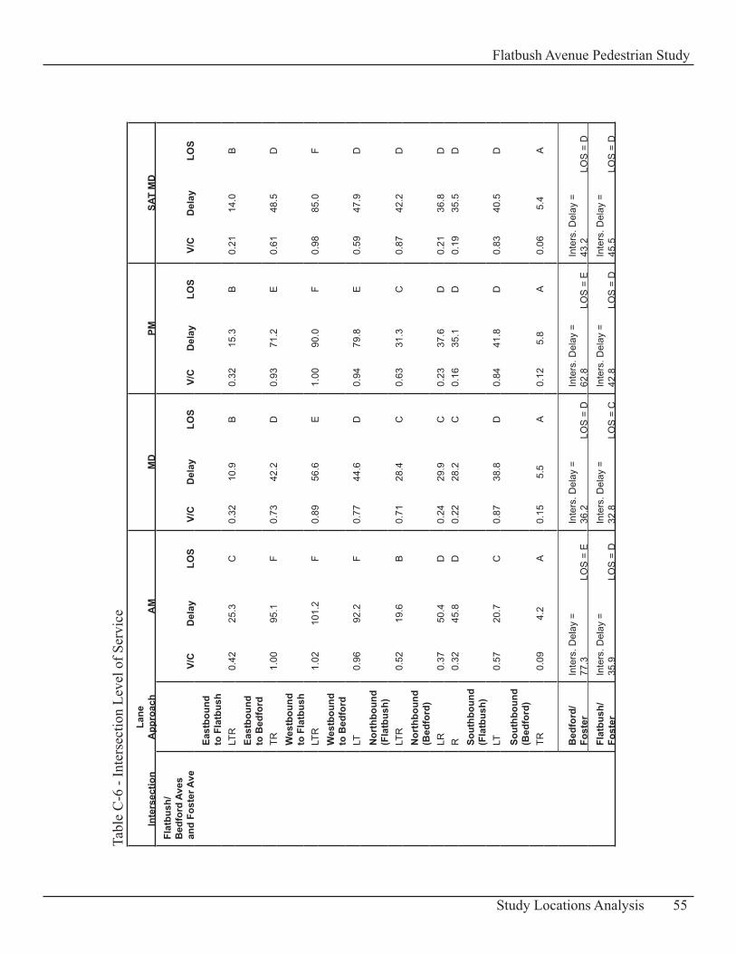
The capacity analysis shows that two of the approaches at this intersection operate acceptably, at LOS C or better for all four peak hours (eastbound to Flatbush Ave. and southbound on Bedford Ave). Three other approaches operate at LOS C or better for at least one peak hour (northbound on Flatbush and Bedford Aves; southbound on Bedford Ave.). However the rest of the intersection approaches operate at LOS D or worse with more than 40 seconds of delay. (Table C-6: Intersection Level of Service)
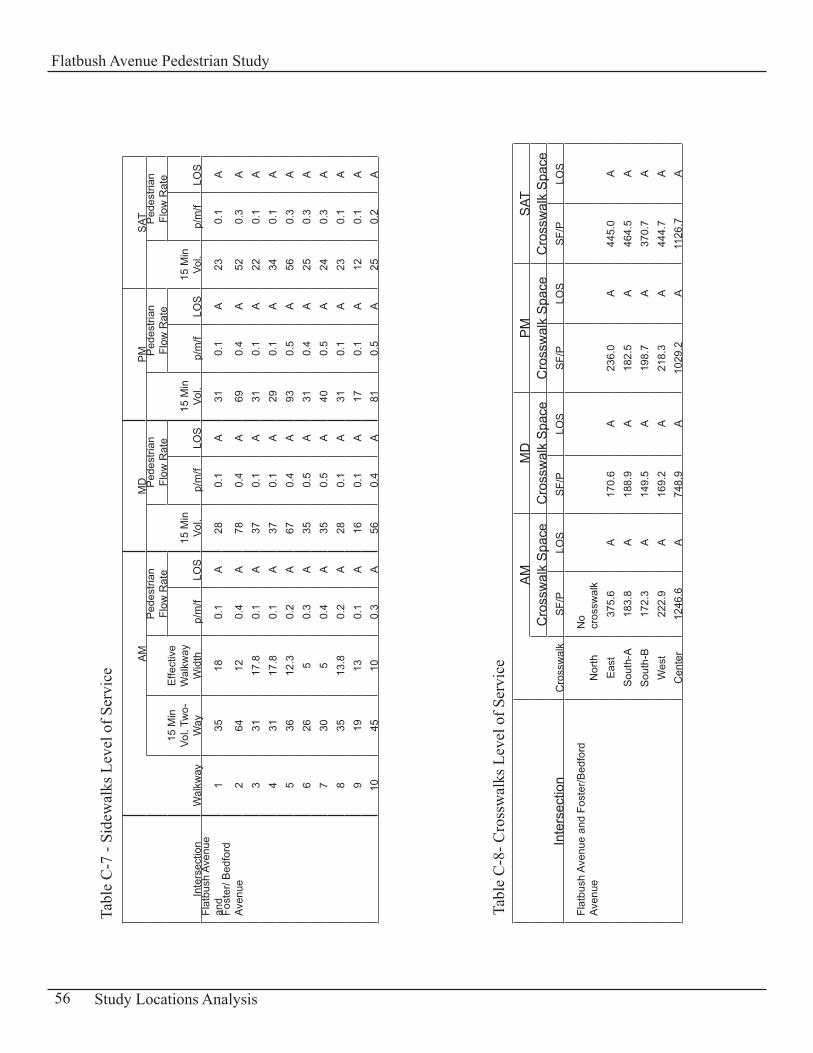
Pedestrian Analysis• An analysis of the sidewalks at Flatbush Avenue/ Bedford Avenue and Foster Avenue indicates that the pedestrian LOS generally operates at a comfortable LOS A during the four peak periods. Table C-7: Sidewalks Level of Service presents a summary of the LOS results and Appendix D-1: “LOS Methodology and Vehicular and Pedestrian Traffic Volumes” has a diagram showing the labeling system for the walkways and crosswalks analyzed.
The corners and the crosswalks of this intersection operate at LOS A for all peak periods. See Tables C-8: Crosswalks Level of Service and C-9: Corners Level of Service.
54 Study Locations Analysis
Flatbush Avenue Pedestrian Study
Inte
rsec
tion
Lane
A
ppro
ach
AM
MD
PMSA
T M
DFl
atbu
sh/
Bed
ford
Ave
s an
d Fo
ster
Ave
V/
CD
elay
LOS
V/C
Del
ayLO
SV/
CD
elay
LOS
V/C
Del
ayLO
S
Ea
stbo
und
to F
latb
ush
LT
R0.
4225
.3C
0.32
10.9
B0.
3215
.3B
0.21
14.0
B
Ea
stbo
und
to B
edfo
rd
TR1.
0095
.1F
0.73
42.2
D0.
9371
.2E
0.61
48.5
D
W
estb
ound
to
Fla
tbus
h
LTR
1.02
101.
2F
0.89
56.6
E1.
0090
.0F
0.98
85.0
F
W
estb
ound
to
Bed
ford
LT
0.96
92.2
F0.
7744
.6D
0.94
79.8
E0.
5947
.9D
N
orth
boun
d (F
latb
ush)
LT
R0.
5219
.6B
0.71
28.4
C0.
6331
.3C
0.87
42.2
D
N
orth
boun
d (B
edfo
rd)
LR
0.37
50.4
D0.
2429
.9C
0.23
37.6
D0.
2136
.8D
R
0.32
45.8
D0.
2228
.2C
0.16
35.1
D0.
1935
.5D
So
uthb
ound
(F
latb
ush)
LT
0.57
20.7
C0.
8738
.8D
0.84
41.8
D0.
8340
.5D
So
uthb
ound
(B
edfo
rd)
TR
0.09
4.2
A0.
155.
5A
0.12
5.8
A0.
065.
4A
B
edfo
rd/
Fost
erIn
ters
. Del
ay =
77
.3LO
S =
EIn
ters
. Del
ay =
36
.2LO
S =
DIn
ters
. Del
ay =
62
.8LO
S =
EIn
ters
. Del
ay =
43
.2LO
S =
D
Fl
atbu
sh/
Fost
erIn
ters
. Del
ay =
35
.9LO
S =
DIn
ters
. Del
ay =
32
.8LO
S =
CIn
ters
. Del
ay =
42
.8LO
S =
DIn
ters
. Del
ay =
45
.5LO
S =
D
55Study Locations Analysis
Flatbush Avenue Pedestrian Study
Tabl
e C
-6 -
Inte
rsec
tion
Leve
l of S
ervi
ce
Inte
rsec
tion
Wal
kway
AM
MD
PM
SAT
15 M
in
Vol.
Two-
Way
Effe
ctiv
e W
alkw
ay
Wid
th
Ped
estri
an
Flow
Rat
e
15 M
in
Vol.
Ped
estri
an
Flow
Rat
e
15 M
in
Vol.
Ped
estri
an
Flow
Rat
e
15 M
in
Vol.
Ped
estri
an
Flow
Rat
e
p/m
/fLO
Sp/
m/f
LOS
p/m
/fLO
Sp/
m/f
LOS
Flat
bush
Ave
nue
and
1
3518
0.1
A28
0.1
A31
0.1
A23
0.1
AFo
ster
/ Bed
ford
Av
enue
264
120.
4A
780.
4A
690.
4A
520.
3A
3
3117
.80.
1A
370.
1A
310.
1A
220.
1A
4
3117
.80.
1A
370.
1A
290.
1A
340.
1A
5
3612
.30.
2A
670.
4A
930.
5A
560.
3A
6
265
0.3
A35
0.5
A31
0.4
A25
0.3
A
730
50.
4A
350.
5A
400.
5A
240.
3A
8
3513
.80.
2A
280.
1A
310.
1A
230.
1A
9
1913
0.1
A16
0.1
A17
0.1
A12
0.1
A
1045
100.
3A
560.
4A
810.
5A
250.
2A
Inte
rsec
tion
Cro
ssw
alk
AM
MD
PM
SAT
Cro
ssw
alk
Spa
ceC
ross
wal
k S
pace
Cro
ssw
alk
Spa
ceC
ross
wal
k S
pace
SF/
PLO
SS
F/P
LOS
SF/
PLO
SS
F/P
LOS
Flat
bush
Ave
nue
and
Fost
er/B
edfo
rd
Aven
ueN
orth
No
cros
swal
k
E
ast
375.
6A
170.
6A
236.
0A
445.
0A
S
outh
-A18
3.8
A18
8.9
A18
2.5
A46
4.5
A
Sou
th-B
172.
3A
149.
5A
198.
7A
370.
7A
W
est
222.
9A
169.
2A
218.
3A
444.
7A
C
ente
r12
46.6
A74
8.9
A10
29.2
A11
26.7
A
56 Study Locations Analysis
Flatbush Avenue Pedestrian Study
Tabl
e C
-7 -
Side
wal
ks L
evel
of S
ervi
ce
Tabl
e C
-8- C
ross
wal
ks L
evel
of S
ervi
ce
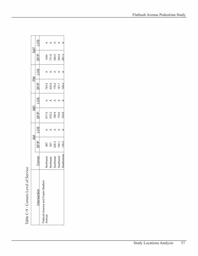
Inte
rsec
tion
Cor
ner
AM
MD
PM
SAT
SF/
PLO
SS
F/P
LOS
SF/
PLO
SS
F/P
LOS
Flat
bush
Ave
nue
and
Fost
er/ B
edfo
rd
Aven
ueN
orth
wes
t86
7A
817.
5A
743.
2A
1244
A
Nor
thea
st50
1A
475.
2A
434.
8A
731.
6A
S
outh
east
226.
3A
198.
9A
178.
2A
346.
5A
S
outh
wes
t19
4.1
A17
9.6
A16
1.7
A35
4.9
A
Sou
thco
rner
135.
0A
153.
6A
128.
4A
281.
3A
57Study Locations Analysis
Flatbush Avenue Pedestrian Study
Tabl
e C
-9 -
Cor
ners
Lev
el o
f Ser
vice
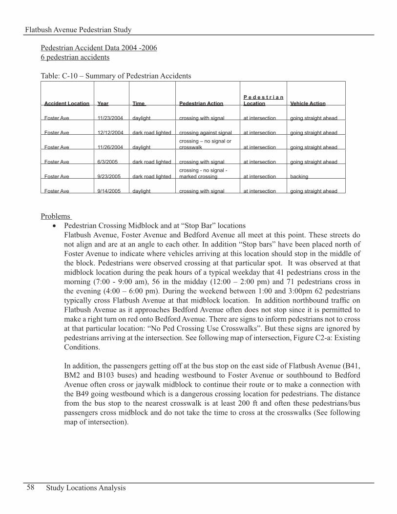
Pedestrian Accident Data 2004 -20066 pedestrian accidents
Table: C-10 – Summary of Pedestrian Accidents
Accident Location Year Time Pedestrian ActionP e d e s t r i a n Location Vehicle Action
Foster Ave 11/23/2004 daylight crossing with signal at intersection going straight ahead
Foster Ave 12/12/2004 dark road lighted crossing against signal at intersection going straight ahead
Foster Ave 11/26/2004 daylightcrossing – no signal or crosswalk at intersection going straight ahead
Foster Ave 6/3/2005 dark road lighted crossing with signal at intersection going straight ahead
Foster Ave 9/23/2005 dark road lightedcrossing - no signal - marked crossing at intersection backing
Foster Ave 9/14/2005 daylight crossing with signal at intersection going straight ahead
Problems Pedestrian Crossing Midblock and at “Stop Bar” locations• Flatbush Avenue, Foster Avenue and Bedford Avenue all meet at this point. These streets do not align and are at an angle to each other. In addition “Stop bars” have been placed north of Foster Avenue to indicate where vehicles arriving at this location should stop in the middle of the block. Pedestrians were observed crossing at that particular spot. It was observed at that midblock location during the peak hours of a typical weekday that 41 pedestrians cross in the morning (7:00 - 9:00 am), 56 in the midday (12:00 – 2:00 pm) and 71 pedestrians cross in the evening (4:00 – 6:00 pm). During the weekend between 1:00 and 3:00pm 62 pedestrians typically cross Flatbush Avenue at that midblock location. In addition northbound traffic on Flatbush Avenue as it approaches Bedford Avenue often does not stop since it is permitted to make a right turn on red onto Bedford Avenue. There are signs to inform pedestrians not to cross at that particular location: “No Ped Crossing Use Crosswalks”. But these signs are ignored by pedestrians arriving at the intersection. See following map of intersection, Figure C2-a: Existing Conditions.
In addition, the passengers getting off at the bus stop on the east side of Flatbush Avenue (B41, BM2 and B103 buses) and heading westbound to Foster Avenue or southbound to Bedford Avenue often cross or jaywalk midblock to continue their route or to make a connection with the B49 going westbound which is a dangerous crossing location for pedestrians. The distance from the bus stop to the nearest crosswalk is at least 200 ft and often these pedestrians/bus passengers cross midblock and do not take the time to cross at the crosswalks (See following map of intersection).
58 Study Locations Analysis
Flatbush Avenue Pedestrian Study
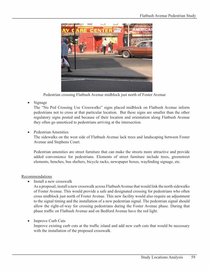
Signage• The “No Ped Crossing Use Crosswalks” signs placed midblock on Flatbush Avenue inform pedestrians not to cross at that particular location. But these signs are smaller than the other regulatory signs posted and because of their location and orientation along Flatbush Avenue they often go unnoticed to pedestrians arriving at the intersection.
Pedestrian Amenities • The sidewalks on the west side of Flatbush Avenue lack trees and landscaping between Foster Avenue and Stephens Court.
Pedestrian amenities are street furniture that can make the streets more attractive and provide added convenience for pedestrians. Elements of street furniture include trees, greenstreet elements, benches, bus shelters, bicycle racks, newspaper boxes, wayfinding signage, etc.
RecommendationsInstall a new crosswalk• As a proposal, install a new crosswalk across Flatbush Avenue that would link the north sidewalks of Foster Avenue. This would provide a safe and designated crossing for pedestrians who often cross midblock just north of Foster Avenue. This new facility would also require an adjustment to the signal timing and the installation of a new pedestrian signal. The pedestrian signal should allow the right-of-way for crossing pedestrians during the Foster Avenue phase. During that phase traffic on Flatbush Avenue and on Bedford Avenue have the red light.
Improve Curb Cuts• Improve existing curb cuts at the traffic island and add new curb cuts that would be necessary with the installation of the proposed crosswalk.
59Study Locations Analysis
Flatbush Avenue Pedestrian Study
Pedestrian crossing Flatbush Avenue midblock just north of Foster Avenue
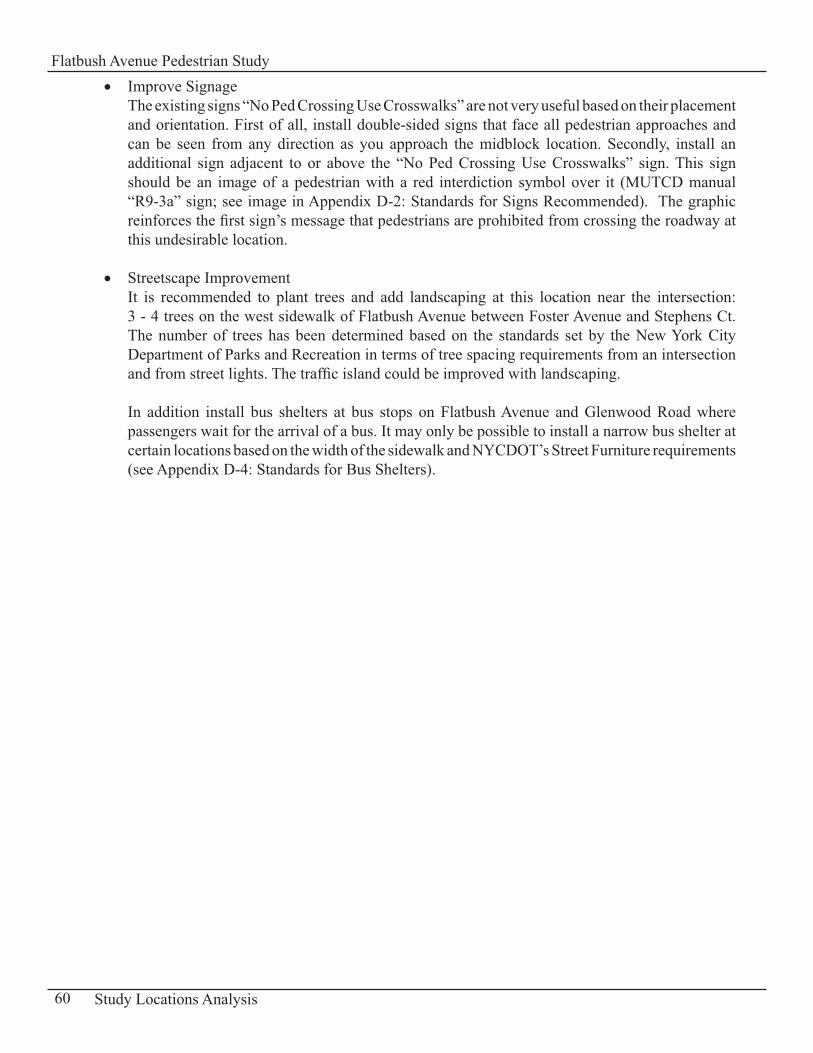
Improve Signage• The existing signs “No Ped Crossing Use Crosswalks” are not very useful based on their placement and orientation. First of all, install double-sided signs that face all pedestrian approaches and can be seen from any direction as you approach the midblock location. Secondly, install an additional sign adjacent to or above the “No Ped Crossing Use Crosswalks” sign. This sign should be an image of a pedestrian with a red interdiction symbol over it (MUTCD manual “R9-3a” sign; see image in Appendix D-2: Standards for Signs Recommended). The graphic reinforces the first sign’s message that pedestrians are prohibited from crossing the roadway at this undesirable location.
Streetscape Improvement • It is recommended to plant trees and add landscaping at this location near the intersection: 3 - 4 trees on the west sidewalk of Flatbush Avenue between Foster Avenue and Stephens Ct. The number of trees has been determined based on the standards set by the New York City Department of Parks and Recreation in terms of tree spacing requirements from an intersection and from street lights. The traffic island could be improved with landscaping.
In addition install bus shelters at bus stops on Flatbush Avenue and Glenwood Road where passengers wait for the arrival of a bus. It may only be possible to install a narrow bus shelter at certain locations based on the width of the sidewalk and NYCDOT’s Street Furniture requirements (see Appendix D-4: Standards for Bus Shelters).
60 Study Locations Analysis
Flatbush Avenue Pedestrian Study
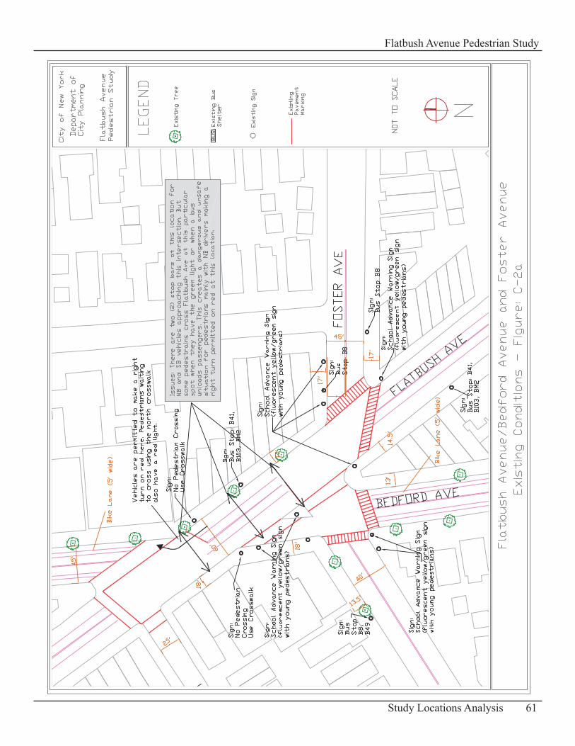
61Study Locations Analysis
Flatbush Avenue Pedestrian Study
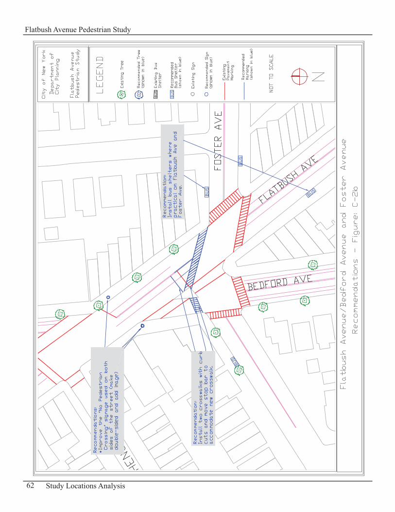
62 Study Locations Analysis
Flatbush Avenue Pedestrian Study
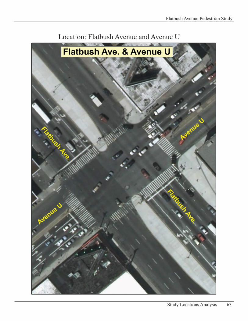
63Study Locations Analysis
Flatbush Avenue Pedestrian Study
Flatbush Ave. & Avenue U
Flatbush Ave.Avenue U
Avenue UFlatbush Ave.
Location: Flatbush Avenue and Avenue U
Intersection of Flatbush Avenue and Avenue UDescription of Existing Conditions Flatbush Avenue is very wide at this location with a width of 145 ft and six travel lanes, in each direction of traffic. Dedicated left and right turning lanes are provided (two lanes for each type of turn in the northbound and southbound directions). The sidewalks along this main arterial are 13 – 14 ft wide. However at the southeast corner the sidewalk is 42 ft wide then merges into a plaza in front of the shopping mall.
Avenue U on the other hand is 85 ft wide with four travel lanes in each direction which are divided into a left turn lane, one through lane, one through-right turn lane and a right turn lane. The sidewalks on Avenue U are 10 - 14 f t wide.
Medians are located in the middle of the roadway for both arterials.
The vehicular volumes are heavy on both streets at this intersection while pedestrian volumes are light but with a steady flow. This location can be considered more of a destination with the Kings Plaza shopping mall and a concentration of big retail stores in the area. Many of the pedestrians observed on the sidewalks come in general from the buses and vans that unload/load passengers heading to/from the shopping mall and the retail stores in the area.
Level of Service Analysis (LOS)Vehicle Analysis•
The capacity analysis shows that all approaches at this intersection operate at LOS C or worse for all peak hours. However the intersection approaches operating at LOS D or worse have more than 35 seconds of delay (See Table C-11- Intersection LOS).
Pedestrian Analysis• An analysis of the sidewalks at Flatbush Avenue and Avenue U indicates that the pedestrian LOS generally operates at a comfortable LOS A during all peak periods. Table C-12: “Sidewalks Level of Service” presents a summary of the LOS results and Appendix D-1 “LOS Methodology and Vehicular and Pedestrian Traffic Volumes” has a diagram showing the numbering system for the walkways analyzed at this intersection.
The corners and crosswalks of this intersection operate at LOS A for the four peak periods analyzed (See Table C-13: Crosswalks Level of Service and Table C-14: Corners Level of Service).
64 Study Locations Analysis
Flatbush Avenue Pedestrian Study
Inte
rsec
tion
Lane
A
ppro
ach
AM
MD
PMSA
T M
DFl
atbu
sh A
venu
e an
d Av
enue
U
V/C
Del
ayLO
SV/
CD
elay
LOS
V/C
Del
ayLO
SV/
CD
elay
LOS
Ea
stbo
und
L
0.75
52.2
D0.
6745
.5D
1.00
90.7
F0.
7448
.0D
TR
0.50
34.5
C0.
6239
.3D
0.56
35.8
D0.
4435
.3D
R
0.27
30.8
C0.
3033
.4C
0.28
31.0
C0.
2132
.0C
W
estb
ound
L
0.89
59.7
E0.
7044
.6D
1.00
78.3
E0.
4635
.5D
TR
0.53
34.6
C0.
5737
.5D
0.70
38.7
D0.
4935
.8D
N
orth
boun
d
L0.
3431
.9C
0.32
31.4
C0.
3635
.7D
0.35
32.0
C
T 1.
0064
.1E
0.82
44.4
D1.
0163
.6E
0.64
38.0
D
R0.
9469
.1E
0.83
55.2
E0.
9975
.8E
0.80
50.7
D
Sout
hbou
nd
L0.
2737
.9D
0.31
33.2
C0.
2941
.4D
0.36
33.2
C
TR0.
6838
.5D
0.71
39.3
D0.
9552
.9D
0.62
37.1
D
In
ters
. Del
ay =
48.
3LO
S =
DIn
ters
. Del
ay =
41.
2LO
S =
DIn
ters
. Del
ay =
56.
2LO
S =
EIn
ters
. Del
ay =
38.
0LO
S =
D
65Study Locations Analysis
Flatbush Avenue Pedestrian Study
Tabl
e C
-11
- Sid
ewal
ks L
evel
of S
ervi
ce
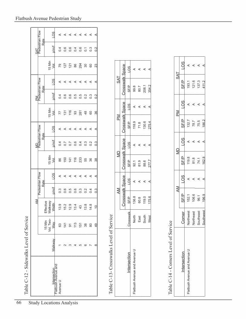
Inte
rsec
tion
Wal
kway
AM
MD
PM
SAT
15 M
in
Vol.
Two-
Way
Effe
ctiv
e W
alkw
ay
Wid
th
Ped
estri
an F
low
R
ate
15 M
in
Vol.
Ped
estri
an F
low
R
ate
15 M
in
Vol.
Ped
estri
an F
low
R
ate
15 M
in
Vol.
Ped
estri
an F
low
R
ate
p/m
/fLO
Sp/
m/f
LOS
p/m
/fLO
Sp/
m/f
LOS
Flat
bush
Ave
nue
and
Aven
ue U
163
13.9
0.3
A86
0.4
A77
0.4
A79
0.4
A
214
115
.20.
6A
150
0.7
A13
10.
6A
127
0.6
A
391
12.9
0.5
A14
10.
7A
116
0.6
A12
10.
6A
4
113
13.4
0.6
A11
60.
6A
930.
5A
860.
4A
5
151
430.
3A
233
0.4
A28
10.
5A
294
0.6
A
638
13.8
0.2
A55
0.3
A48
0.2
A30
0.1
A
780
14.8
0.4
A36
0.2
A60
0.3
A60
0.3
A
849
100.
3A
380.
3A
360.
2A
230.
2A
Inte
rsec
tion
Cro
ssw
alk
AM
MD
PM
SAT
Cro
ssw
alk
Spa
ceC
ross
wal
k S
pace
Cro
ssw
alk
Spa
ceC
ross
wal
k S
pace
SF/
PLO
SS
F/P
LOS
SF/
PLO
SS
F/P
LOS
Flat
bush
Ave
nue
and
Aven
ue U
Nor
th13
6.8
A92
.1A
118.
9A
99.8
A
Eas
t 60
.8A
81.9
A71
.8A
80.7
A
Sou
th11
9.0
A88
.6A
130.
6A
208.
1A
W
est
175.
6A
277.
7A
275.
4A
354.
2A
Inte
rsec
tion
Cor
ner
AM
MD
PM
SAT
SF/
PLO
SS
F/P
LOS
SF/
PLO
SS
F/P
LOS
Flat
bush
Ave
nue
and
Aven
ue U
Nor
thw
est
152.
1A
119.
8A
132.
7A
193.
1A
N
orth
east
106.
6A
81.8
A78
.7A
121.
6A
S
outh
east
96.1
A74
.1A
75.5
A13
7.3
A
Sou
thw
est
196.
9A
162.
8A
186.
2A
411.
2A
66 Study Locations Analysis
Flatbush Avenue Pedestrian StudyTa
ble
C-1
2 - S
idew
alks
Lev
el o
f Ser
vice
Tabl
e C
-14
- Cor
ners
Lev
el o
f Ser
vice
Tabl
e C
-13-
Cro
ssw
alks
Lev
el o
f Ser
vice
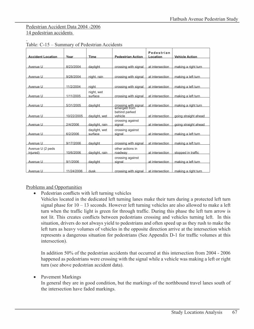
Pedestrian Accident Data 2004 -200614 pedestrian accidents Table: C-15 – Summary of Pedestrian Accidents
Accident Location Year Time Pedestrian ActionP e d e s t r i a n Location Vehicle Action
Avenue U 8/23/2004 daylight crossing with signal at intersection making a right turn
Avenue U 9/28/2004 night, rain crossing with signal at intersection making a left turn
Avenue U 11/2/2004 night crossing with signal at intersection making a left turn
Avenue U 1/11/2005night, wet surface crossing with signal at intersection making a left turn
Avenue U 5/31/2005 daylight crossing with signal at intersection making a right turn
Avenue U 10/22/2005 daylight, wet
emerged from behind parked vehicle at intersection going straight ahead
Avenue U 2/4/2006 daylight, raincrossing against signal at intersection going straight ahead
Avenue U 6/2/2006daylight, wet surface
crossing against signal at intersection making a left turn
Avenue U 9/17/2006 daylight crossing with signal at intersection making a left turnAvenue U (2 peds injured) 10/6/2006 daylight, rain
other actions in roadway at intersection stopped in traffic
Avenue U 9/1/2006 daylightcrossing against signal at intersection making a left turn
Avenue U 11/24/2006 dusk crossing with signal at intersection making a right turn
Problems and OpportunitiesPedestrian conflicts with left turning vehicles• Vehicles located in the dedicated left turning lanes make their turn during a protected left turn signal phase for 10 – 13 seconds. However left turning vehicles are also allowed to make a left turn when the traffic light is green for through traffic. During this phase the left turn arrow is not lit. This creates conflicts between pedestrians crossing and vehicles turning left. In this situation, drivers do not always yield to pedestrians and often speed up as they rush to make the left turn as heavy volumes of vehicles in the opposite direction arrive at the intersection which represents a dangerous situation for pedestrians (See Appendix D-1 for traffic volumes at this intersection).
In addition 50% of the pedestrian accidents that occurred at this intersection from 2004 - 2006 happened as pedestrians were crossing with the signal while a vehicle was making a left or right turn (see above pedestrian accident data). Pavement Markings• In general they are in good condition, but the markings of the northbound travel lanes south of the intersection have faded markings.
67Study Locations Analysis
Flatbush Avenue Pedestrian Study
Pedestrian Amenities• There are no trees along the medians and on the sidewalks at all approaches of the intersection
Pedestrian refuge/median• The medians or pedestrian refuge on Avenue U stop just before the crosswalk. They are 4ft wide and are not ADA (American Disability Act) accessible which leave pedestrians and wheelchair users stranded in the crosswalk waiting for the next green phase to cross.
RecommendationsFuture Restriction of Turns • Due to major vehicular and pedestrian conflicts affecting pedestrian’s safety at this intersection, it is possible that left turns by vehicles may have to be restricted in the future, especially on Flatbush Avenue. This would require reconfiguration of the intersection and new signal timing.
Increase Enforcement• An increase in police presence is recommended for this location for enforcement of traffic regulations.
Improve Pavement Markings• Repair and restripe pavement markings of the northbound travel lanes south of the intersection
Provide Additional Pedestrian Amenities• Have trees/planters and landscaping along the medians and on the sidewalks where possible.
Consideration for the Future Recommendation for a Countdown Pedestrian SignalThe installation of a countdown pedestrian signal is recommended for consideration at Flatbush Avenue and Avenue U, to reduce conflicts between pedestrians crossing and vehicles making turns. This type of traffic signal can provide pedestrians with information about the amount of time remaining in a crossing interval and can improve pedestrian signal compliance. This pedestrian countdown signal is recommended as a future pilot program.
Currently New York City Department of Transportation (NYCDOT) is conducting a study and a pilot program of countdown pedestrian signals at 24 intersections. This pilot program has been expanded and will also take place along selected busy corridors in all five boroughs. This study is to be completed in the fall of 2008 (Source: DOT Press Release on 11/8/07).
68 Study Locations Analysis
Flatbush Avenue Pedestrian Study
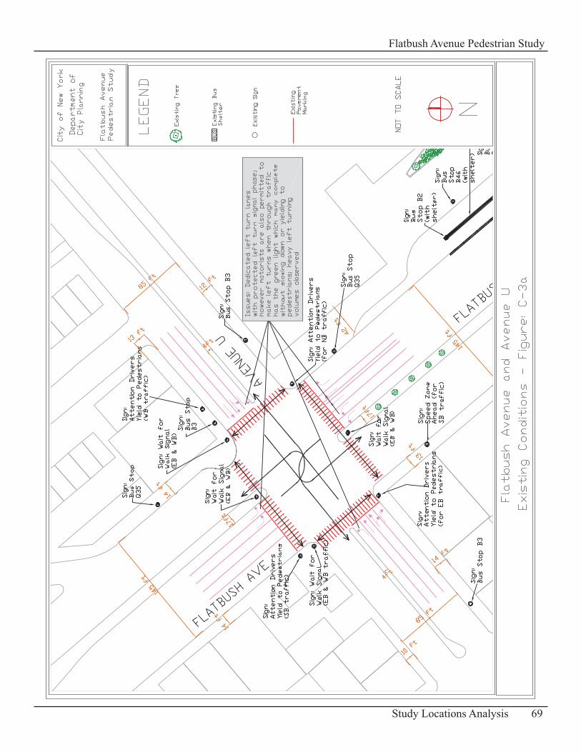
69Study Locations Analysis
Flatbush Avenue Pedestrian Study
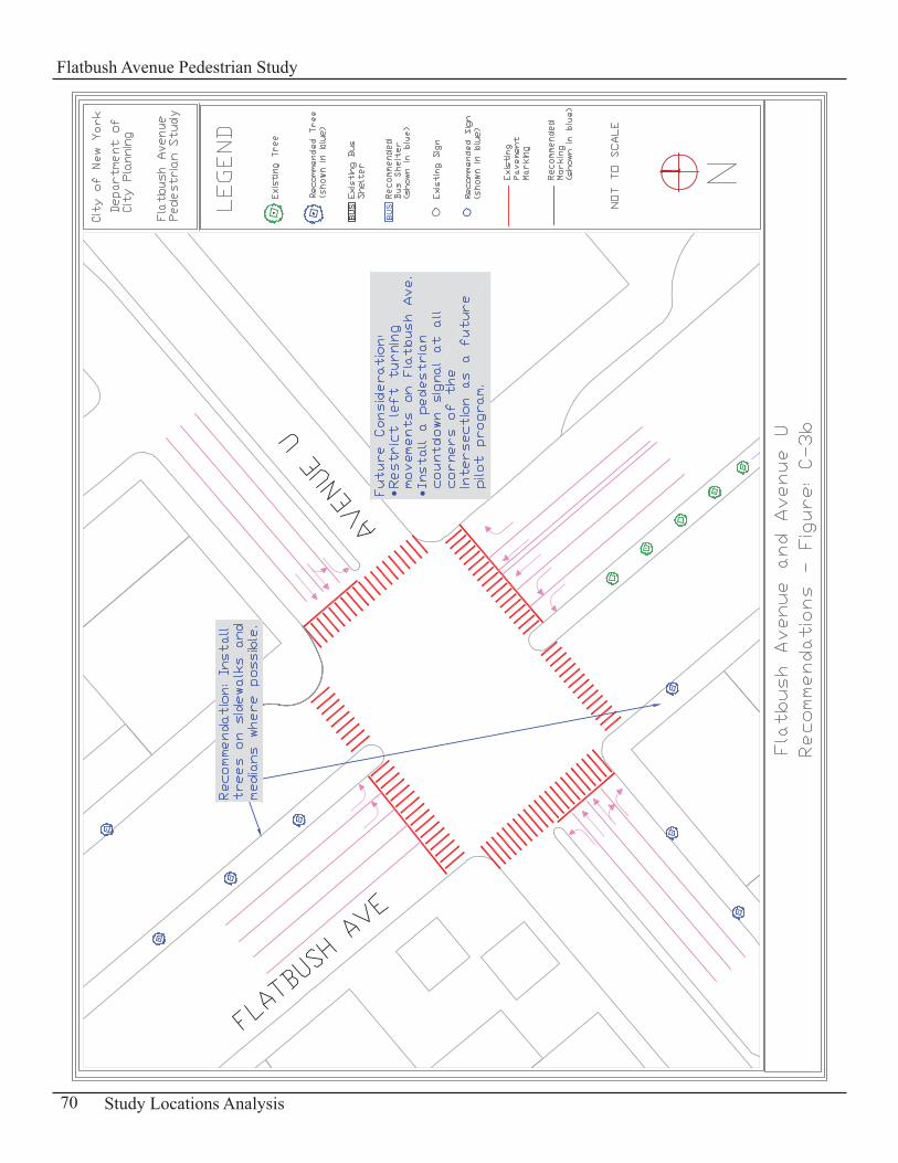
70 Study Locations Analysis
Flatbush Avenue Pedestrian Study
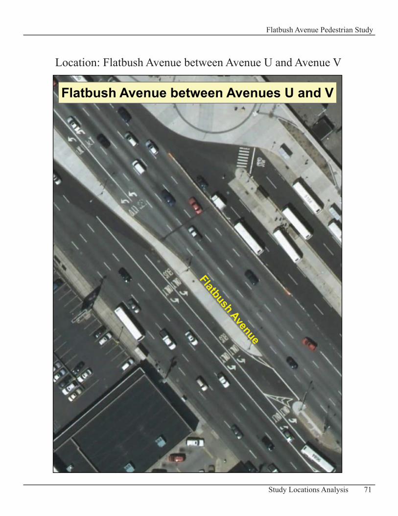
71Study Locations Analysis
Flatbush Avenue Pedestrian Study
Location: Flatbush Avenue between Avenue U and Avenue V
Flatbush Avenue
Flatbush Avenue between Avenues U and V
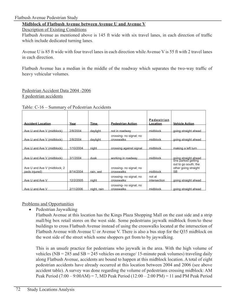
Midblock of Flatbush Avenue between Avenue U and Avenue VDescription of Existing Conditions Flatbush Avenue as mentioned above is 145 ft wide with six travel lanes, in each direction of traffic which include dedicated turning lanes.
Avenue U is 85 ft wide with four travel lanes in each direction while Avenue V is 55 ft with 2 travel lanes in each direction.
Flatbush Avenue has a median in the middle of the roadway which separates the two-way traffic of heavy vehicular volumes.
Pedestrian Accident Data 2004 -20068 pedestrian accidents
Table: C-16 – Summary of Pedestrian Accidents
Accident Location Year Time Pedestrian ActionP e d e s t r i a n Location Vehicle Action
Ave U and Ave V (midblock) 2/8/2004 daylight not in roadway midblock going straight ahead
Ave U and Ave V (midblock) 2/8/2004 daylightcrossing- no signal; no crosswalks midblock going straight ahead
Ave U and Ave V (midblock) 1/10/2004 night crossing against signal midblock making a left turn
Ave U and Ave V (midblock) 3/1/2004 dusk working in roadway midblock going straight ahead
Ave U and Ave V (midblock; 2 peds injured) 8/14/2004 rain, wet
crossing- no signal; no crosswalks midblock
one parked getting out to go south; the other going straight SB
Ave U and Ave V 12/2/2005 nightcrossing- no signal; no crosswalks
not at intersection going straight ahead
Ave U and Ave V 2/11/2006 night, raincrossing- no signal; no crosswalks midblock going straight ahead
Problems and OpportunitiesPedestrian Jaywalking• Flatbush Avenue at this location has the Kings Plaza Shopping Mall on the east side and a strip mall/big box retail stores on the west side. Some pedestrians jaywalk midblock from/to these buildings to cross Flatbush Avenue instead of using the crosswalks located at the intersection of Flatbush Avenue with Avenue U or Avenue V. There is also a bus stop for the Q35 midblock on the west side of the street which some shoppers get from/to by jaywalking. This is an unsafe practice for pedestrians who jaywalk in the area. With the high volume of vehicles (NB = 285 and SB = 245 vehicles on average/ 15-minute peak volumes) traveling daily along Flatbush Avenue, accidents are bound to happen at this midblock location. A total of eight pedestrian accidents have already occurred at this location between 2004 and 2006 (see above accident table). A survey was done regarding the volume of pedestrians crossing midblock: AM Peak Period (7:00 – 9:00AM) = 7, MD Peak Period (12:00 – 2:00 PM) = 11 and PM Peak Period
72 Study Locations Analysis
Flatbush Avenue Pedestrian Study
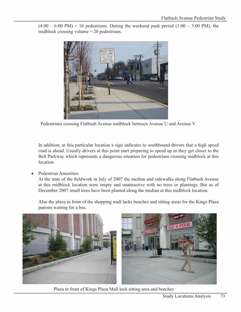
(4:00 – 6:00 PM) = 10 pedestrians. During the weekend peak period (1:00 – 3:00 PM), the midblock crossing volume = 20 pedestrians.
In addition, at this particular location a sign indicates to southbound drivers that a high speed road is ahead. Usually drivers at this point start preparing to speed up as they get closer to the Belt Parkway which represents a dangerous situation for pedestrians crossing midblock at this location.
Pedestrian Amenities • At the time of the fieldwork in July of 2007 the median and sidewalks along Flatbush Avenue at this midblock location were empty and unattractive with no trees or plantings. But as of December 2007 small trees have been planted along the median at this midblock location.
Also the plaza in front of the shopping mall lacks benches and sitting areas for the Kings Plaza patrons waiting for a bus.
73Study Locations Analysis
Flatbush Avenue Pedestrian Study
Pedestrians crossing Flatbush Avenue midblock between Avenue U and Avenue V
Plaza in front of Kings Plaza Mall lack sitting area and benches
RecommendationsInstall a barrier • Plant shrubs along the median in between Avenue U and Avenue V to block and discourage pedestrian from jaywalking. In addition, have some of the following signs installed midblock “Cross only at Crosswalks” and “Use Crosswalk (with a directional arrow)” directing pedestrians to the crosswalks at Avenue U or Avenue V (MUTCD Manual R9-2 and R9-3b signs; see Appendix D-2: Standards for Recommended Signs).
Provide Additional Pedestrian Amenities• Place trees/planters on the sidewalks where possible. In terms of the medians on Flatbush Avenue, they recently as of December 2007, had small trees planted.
Additional sitting areas at the entrance of the Kings Plaza shopping mall would be convenient for patrons waiting for the arrival of the bus.
74 Study Locations Analysis
Flatbush Avenue Pedestrian Study
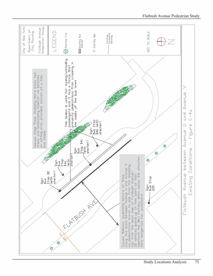
75Study Locations Analysis
Flatbush Avenue Pedestrian Study
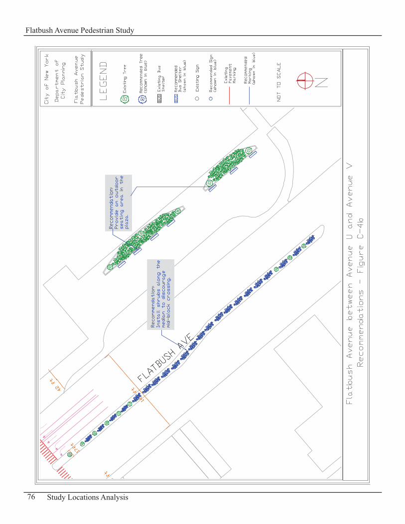
76 Study Locations Analysis
Flatbush Avenue Pedestrian Study

77Study Locations Analysis
Flatbush Avenue Pedestrian Study

78 Study Locations Analysis
Flatbush Avenue Pedestrian Study
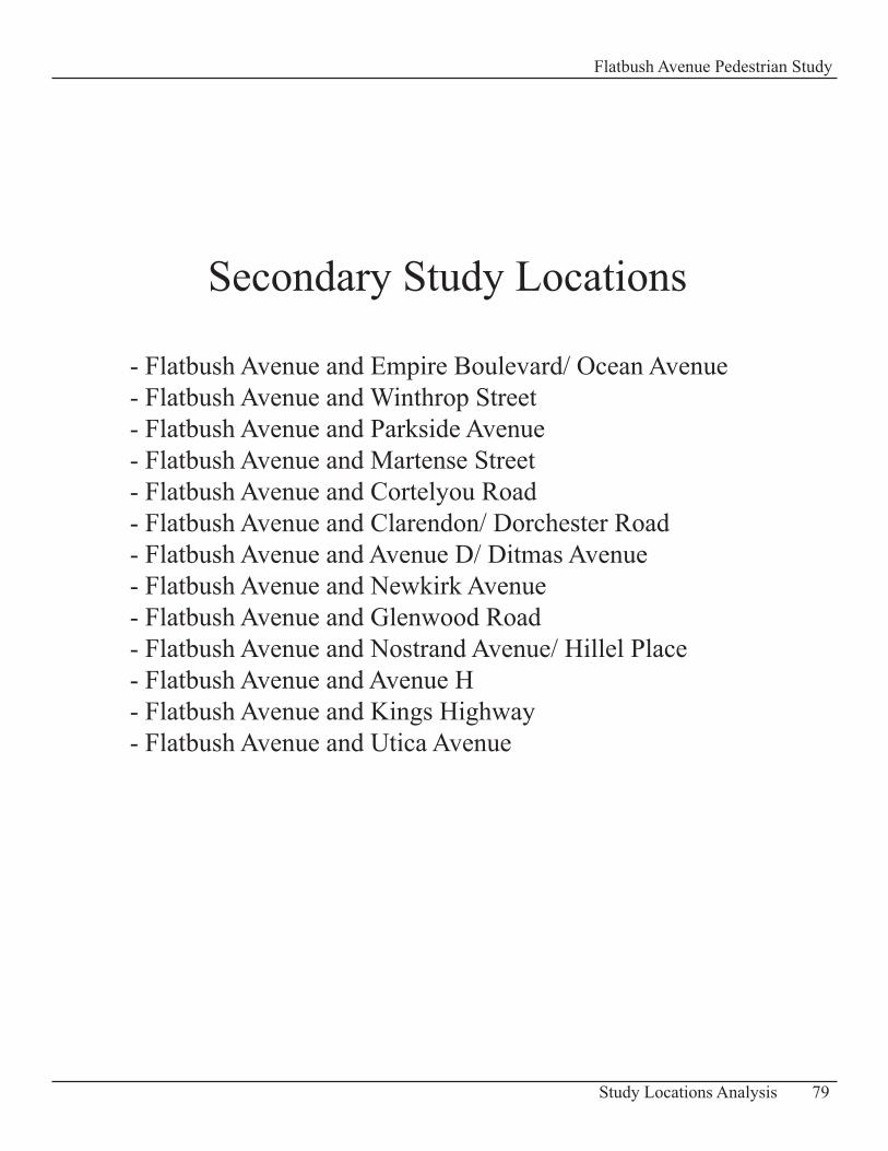
79Study Locations Analysis
Flatbush Avenue Pedestrian Study
Secondary Study Locations
- Flatbush Avenue and Empire Boulevard/ Ocean Avenue- Flatbush Avenue and Winthrop Street- Flatbush Avenue and Parkside Avenue- Flatbush Avenue and Martense Street - Flatbush Avenue and Cortelyou Road- Flatbush Avenue and Clarendon/ Dorchester Road- Flatbush Avenue and Avenue D/ Ditmas Avenue- Flatbush Avenue and Newkirk Avenue- Flatbush Avenue and Glenwood Road- Flatbush Avenue and Nostrand Avenue/ Hillel Place- Flatbush Avenue and Avenue H- Flatbush Avenue and Kings Highway - Flatbush Avenue and Utica Avenue

80 Study Locations Analysis
Flatbush Avenue Pedestrian Study
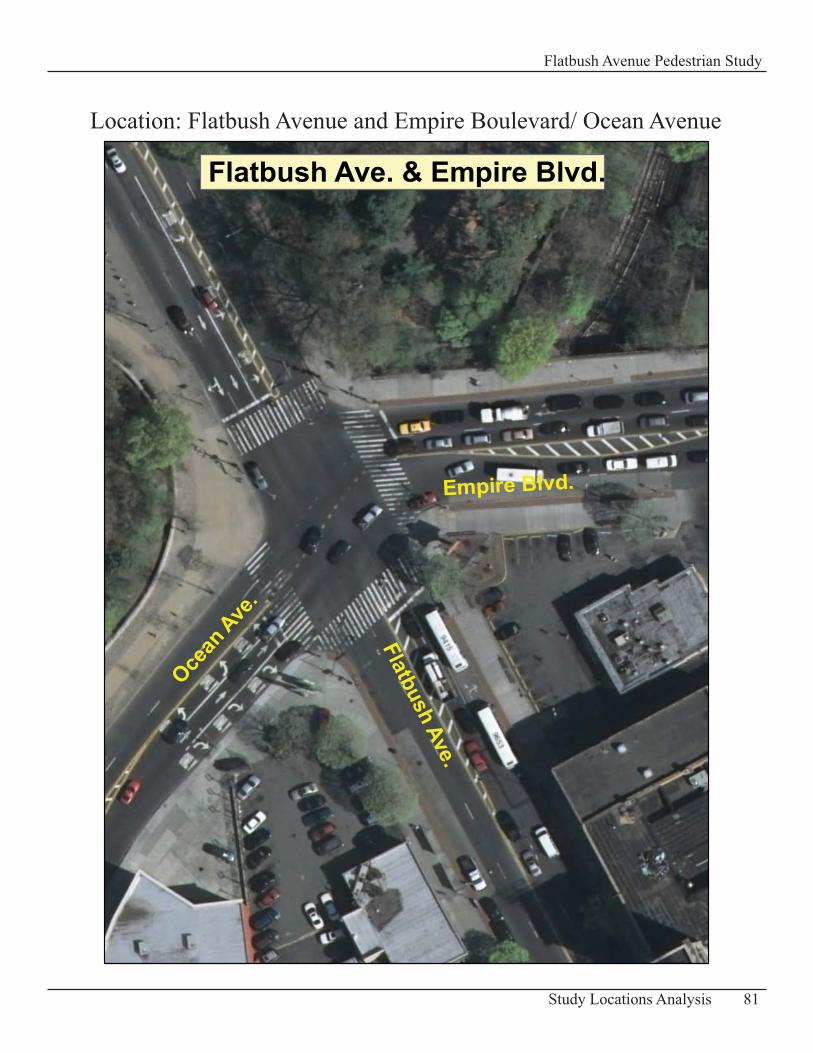
81Study Locations Analysis
Flatbush Avenue Pedestrian Study
Flatbush Ave. & Empire Blvd.
Flatbush Ave.
Empire Blvd.
Ocean
Ave.
Location: Flatbush Avenue and Empire Boulevard/ Ocean Avenue
Intersection of Flatbush Avenue and Empire Boulevard/Ocean AvenueDescription of Existing ConditionsFlatbush Avenue has a width of 60 ft at this location. In the northbound direction, there are two travel lanes while the southbound direction has a through lane, a right-turn-through lane, and a left-turn lane. The sidewalks along this street are about 20 ft wide, however in front of the Brooklyn Botanic Garden and Prospect Park they widen to 25ft and 30 ft respectively.
Empire Boulevard is 70 ft wide and Ocean Avenue is 60 ft wide approximately. Each has through and turning lanes for vehicles. The sidewalks’ dimensions range from 19 to 20 ft.
This area has heavy vehicular volumes where three major arterials intersect at an irregular angle: Empire Boulevard and Ocean Avenue do not intersect with Flatbush Avenue at a right angle. The heaviest volumes were observed in the morning and evening rush hours. Pedestrian volumes are in general light, but moderate in the afternoon and early evening. The pedestrian volumes are mainly generated by subway/ bus users and the major attractions in the area such as the Brooklyn Botanic Garden, Prospect Park and a concentration of fast food restaurants.
There is a short Lead Pedestrian Interval (LPI) phase of 6 seconds for pedestrians crossing Empire Boulevard and Ocean Avenue.
Pedestrian Accident Data 2004 -20066 Pedestrian Accidents
Table: C-17 – Summary of Pedestrian Accidents
Accident Location Year Time Pedestrian ActionP e d e s t r i a n Location Vehicle Action
Empire Blvd / Ocean Ave 1/20/2004 daylightcrossing – no signal or crosswalk midblock
going straight ahead
Empire Blvd / Ocean Ave 9/06/2004 daylight not reported at intersection making a left turn
Empire Blvd / Ocean Ave 8/11/2005 daylight not reported at intersection making a left turn
Empire Blvd / Ocean Ave 5/17/2006 not reported not reported at intersection not reported
Empire Blvd / Ocean Ave 5/13/2006 daylight not in roadwaynot at intersection backing
Empire Blvd / Ocean Ave 6/13/2006 daylight crossing with signal at intersectiongoing straight ahead
82 Study Locations Analysis
Flatbush Avenue Pedestrian Study
Problems Pedestrians Crossing Midblock• More pedestrians than usual were crossing midblock on Flatbush Avenue between Empire Boulevard and Sterling Street. This occurs mainly whenever there is a gap in vehicular traffic. One important factor that contributes to this behavior is that this block is quite long with a length of approximately 500 ft. Most pedestrians cross midblock to the other side of the street as they come out of or head to the B, Q, S subway station located on the west side of the street midblock.
A sample data collection of pedestrian volumes crossing midblock for this location was done on Tuesday, December 11, 2007 from 9:15 – 9:30 AM and included subway riders crossing midblock to/from the subway station. A total of 69 people were observed crossing during those 15 minutes.
In addition there are pavement markings indicating a traffic island on Flatbush Avenue that pedestrians use to cross midblock. This traffic island is south of the intersection with a length of approximately 100 ft from the intersection in between the northbound and southbound travel lanes.
Pedestrian Amenities• The southwest corner has three concrete posts with signage announcing Flatbush Avenue for motorists and pedestrians traveling through the area. This corner also has a wide sidewalk, but it is empty and barren. The MTA has an existing parking lot at that corner for employees with private vehicles and extends their parking activity onto this sidewalk space at the corner beyond the fence, which is unattractive compared to the other three landscaped corners.
The illegal parking on the sidewalk also creates conflicts with pedestrians, with cars pulling in and out of that public space while pedestrians are present.
Recommendations 83Study Locations Analysis
Flatbush Avenue Pedestrian Study
Pedestrians crossing Flatbush Avenue midlock between Empire Blvd and Sterling Street
Extend Center Island Refuge• Extend the existing marked center traffic island on Flatbush Avenue by 100 ft to provide a refuge for pedestrians who nonetheless will cross midblock because of the length of the block between Empire Boulevard/ Ocean Avenue and Sterling Street. In addition it would reduce vehicular speed on Flatbush Avenue at this location with the narrowing of the travel lanes. This extended striped traffic island should maintain its current width.
New Signage • A combination of the following signs could be used at this location and installed midblock to deter pedestrians from jaywalking midblock:
“No Ped Crossing Use Crosswalks” sign that is double-sided and can be seen from any � direction as you approach the midblock location“A sign that has an image of a pedestrian with a red interdiction symbol over it” (MUTCD � manual “R9-3a” sign, see Appendix D-2: Standards for Signs Recommended) “Use Crosswalk” sign with a directional arrow to direct pedestrians to the crosswalks � (MUTCD Manual R9-3b sign, see Appendix D-2: Standards for Signs Recommended).
Streetscape Improvement • Eliminate the practice of parking vehicles on the sidewalk at the southwest corner with the cooperation of the MTA and NYC Department of Transportation. In this space, install landscaping instead and put in greenstreets elements to enhance and beautify this corner which can be more in harmony with the other landscaped corners of this intersection.
84 Study Locations Analysis
Flatbush Avenue Pedestrian Study
Vehicles parked on sidewalk at southwest corner of intersection
85Study Locations Analysis
Flatbush Avenue Pedestrian Study
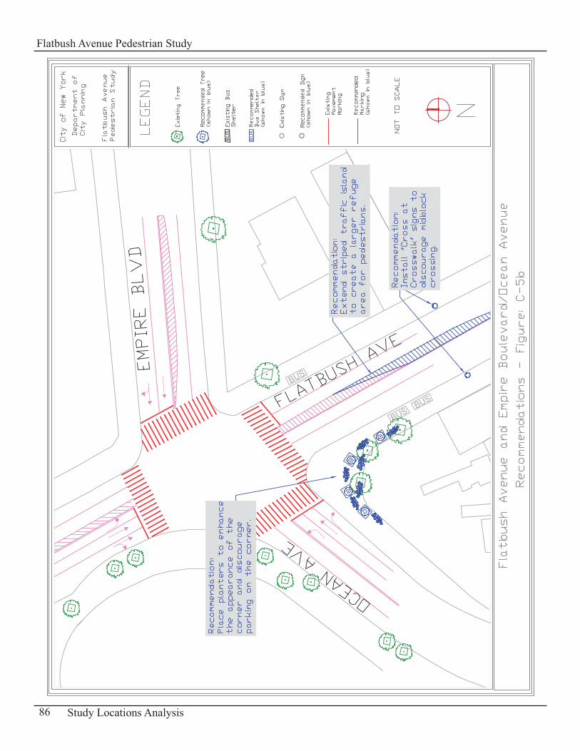
86 Study Locations Analysis
Flatbush Avenue Pedestrian Study
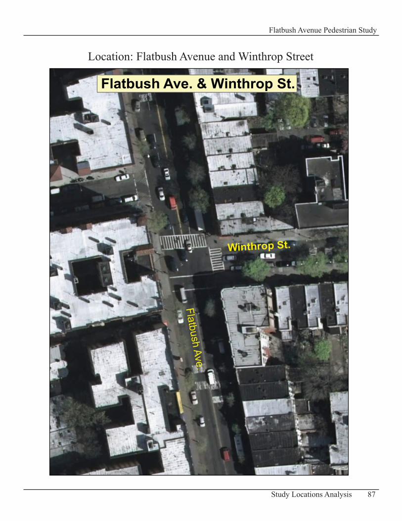
87Study Locations Analysis
Flatbush Avenue Pedestrian Study
Flatbush Ave. & Winthrop St.
Flatbush Ave.
Winthrop St.
Location: Flatbush Avenue and Winthrop Street
Intersection of Flatbush Avenue and Winthrop Street Description of Existing Conditions The intersection of Flatbush Avenue and Winthrop Street is a T-shaped intersection.
Flatbush Avenue has a width of 55ft in this part of the study area with two travel lanes in each direction of traffic.
Winthrop Street is 30 ft wide and is a one-way westbound street with all vehicles making a turn onto Flatbush Avenue.
Vehicle volumes on Flatbush Avenue at this intersection is moderate and can get heavy at times. Winthrop Street on the other hand has light vehicle volumes. Pedestrian volumes in general are light at this location.
Pedestrian Accident Data 2004 -20065 Pedestrian Accidents
Table: C-18 – Summary of Pedestrian Accidents
Accident Location Year Time Pedestrian ActionP e d e s t r i a n Location Vehicle Action
Winthrop St 9/8/2004 dawn, rain crossing with signal at intersection making a left turn
Winthrop St 1/1/2005 daylight crossing with signal at intersection making a left turn
Winthrop St 4/6/2005 daylight crossing with signal at intersection making a left turn
Winthrop St 3/29/2005 daylight crossing with signal at intersection going straight ahead
Winthrop St 7/26/2005 dusk crossing with signal at intersection making a left turn
Problems Pedestrian/ Vehicle Conflicts • Similar to other intersections there are often conflicts with vehicles making a turn and pedestrians crossing with the green light. The pedestrian accident data from 2004 to 2006 revealed that all pedestrians (5 pedestrians) were injured at this intersection during vehicular turning movements from Winthrop Street as pedestrians were crossing with the signal.
88 Study Locations Analysis
Flatbush Avenue Pedestrian Study
RecommendationsReduce Conflicts• It is recommended to install at the northeast and southeast corners of the intersection “Attention Drivers Yield to Pedestrians” signs (with graphics – See Appendix D-2) to get motorists to slow down and stop for pedestrians and also to be more aware of the presence of pedestrians at this intersection.
Increase Enforcement• An increase in police presence on Flatbush Avenue is recommended to enforce observance of the New York State law which requires vehicles to yield to pedestrians legally using a marked crosswalk.
89Study Locations Analysis
Flatbush Avenue Pedestrian Study
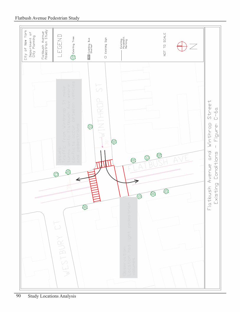
90 Study Locations Analysis
Flatbush Avenue Pedestrian Study

91Study Locations Analysis
Flatbush Avenue Pedestrian Study

92 Study Locations Analysis
Flatbush Avenue Pedestrian Study
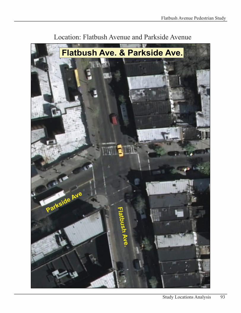
93Study Locations Analysis
Flatbush Avenue Pedestrian Study
Flatbush Ave. & Parkside Ave.
Flatbush Ave.
Parkside Ave
Location: Flatbush Avenue and Parkside Avenue
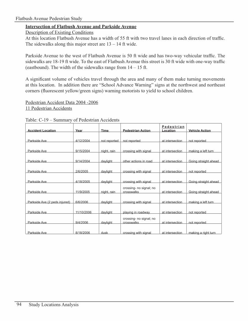
Intersection of Flatbush Avenue and Parkside AvenueDescription of Existing ConditionsAt this location Flatbush Avenue has a width of 55 ft with two travel lanes in each direction of traffic. The sidewalks along this major street are 13 – 14 ft wide.
Parkside Avenue to the west of Flatbush Avenue is 50 ft wide and has two-way vehicular traffic. The sidewalks are 18-19 ft wide. To the east of Flatbush Avenue this street is 30 ft wide with one-way traffic (eastbound). The width of the sidewalks range from 14 – 15 ft.
A significant volume of vehicles travel through the area and many of them make turning movements at this location. In addition there are “School Advance Warning” signs at the northwest and northeast corners (fluorescent yellow/green signs) warning motorists to yield to school children.
Pedestrian Accident Data 2004 -200611 Pedestrian Accidents
Table: C-19 – Summary of Pedestrian Accidents
Accident Location Year Time Pedestrian ActionP e d e s t r i a n Location Vehicle Action
Parkside Ave 4/12/2004 not reported not reported at intersection not reported
Parkside Ave 9/15/2004 night, rain crossing with signal at intersection making a left turn
Parkside Ave 9/14/2004 daylight other actions in road at intersection Going straight ahead
Parkside Ave 2/6/2005 daylight crossing with signal at intersection not reported
Parkside Ave 4/18/2005 daylight crossing with signal at intersection Going straight ahead
Parkside Ave 11/9/2005 night, raincrossing- no signal; no crosswalks at intersection Going straight ahead
Parkside Ave (2 peds injured) 6/6/2006 daylight crossing with signal at intersection making a left turn
Parkside Ave 11/10/2006 daylight playing in roadway at intersection not reported
Parkside Ave 9/4/2006 daylight crossing- no signal; no crosswalks at intersection not reported
Parkside Ave 8/18/2006 dusk crossing with signal at intersection making a right turn
94 Study Locations Analysis
Flatbush Avenue Pedestrian Study
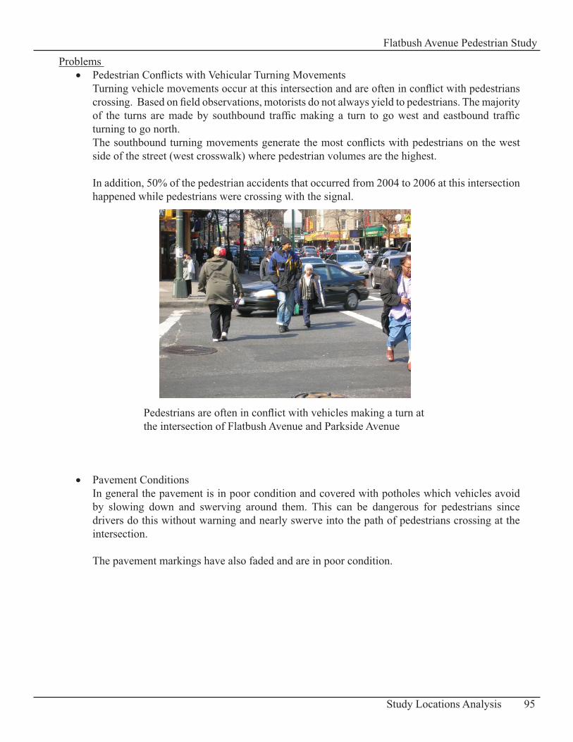
Problems Pedestrian Conflicts with Vehicular Turning Movements• Turning vehicle movements occur at this intersection and are often in conflict with pedestrians crossing. Based on field observations, motorists do not always yield to pedestrians. The majority of the turns are made by southbound traffic making a turn to go west and eastbound traffic turning to go north. The southbound turning movements generate the most conflicts with pedestrians on the west side of the street (west crosswalk) where pedestrian volumes are the highest.
In addition, 50% of the pedestrian accidents that occurred from 2004 to 2006 at this intersection happened while pedestrians were crossing with the signal.
Pavement Conditions• In general the pavement is in poor condition and covered with potholes which vehicles avoid by slowing down and swerving around them. This can be dangerous for pedestrians since drivers do this without warning and nearly swerve into the path of pedestrians crossing at the intersection.
The pavement markings have also faded and are in poor condition.
95Study Locations Analysis
Flatbush Avenue Pedestrian Study
Pedestrians are often in conflict with vehicles making a turn atthe intersection of Flatbush Avenue and Parkside Avenue
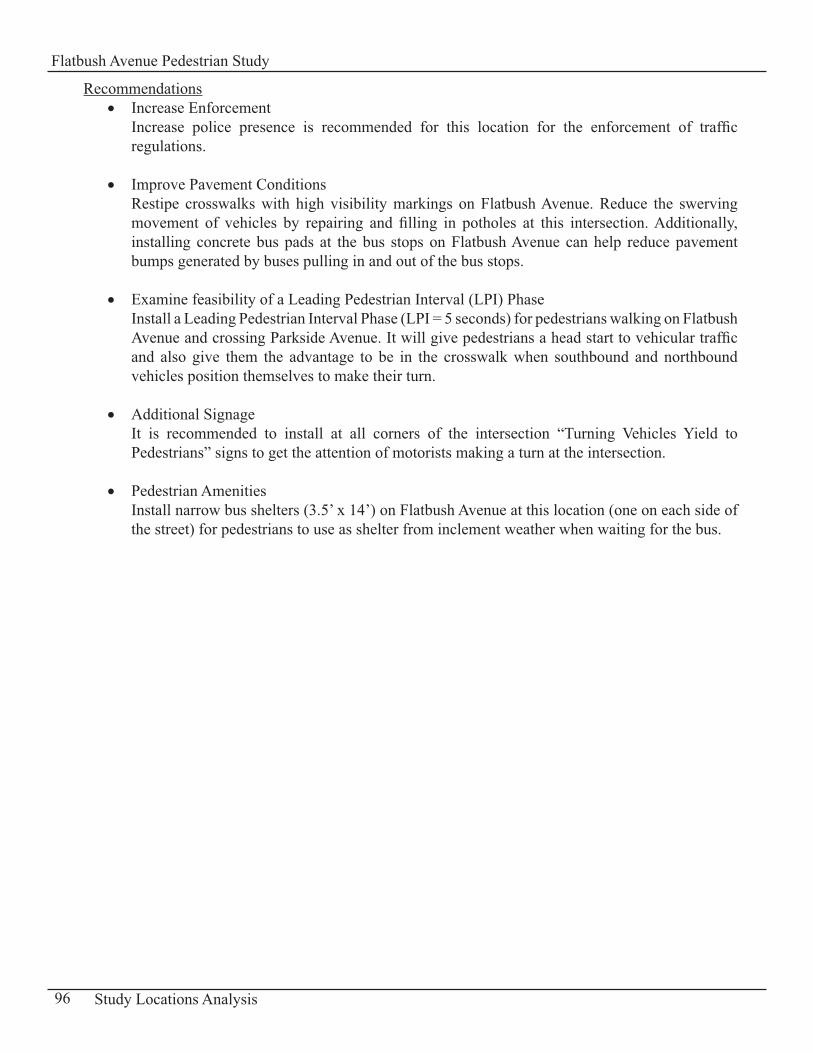
RecommendationsIncrease Enforcement• Increase police presence is recommended for this location for the enforcement of traffic regulations. Improve Pavement Conditions • Restipe crosswalks with high visibility markings on Flatbush Avenue. Reduce the swerving movement of vehicles by repairing and filling in potholes at this intersection. Additionally, installing concrete bus pads at the bus stops on Flatbush Avenue can help reduce pavement bumps generated by buses pulling in and out of the bus stops.
Examine feasibility of a Leading Pedestrian Interval (LPI) Phase• Install a Leading Pedestrian Interval Phase (LPI = 5 seconds) for pedestrians walking on Flatbush Avenue and crossing Parkside Avenue. It will give pedestrians a head start to vehicular traffic and also give them the advantage to be in the crosswalk when southbound and northbound vehicles position themselves to make their turn.
Additional Signage• It is recommended to install at all corners of the intersection “Turning Vehicles Yield to Pedestrians” signs to get the attention of motorists making a turn at the intersection.
Pedestrian Amenities• Install narrow bus shelters (3.5’ x 14’) on Flatbush Avenue at this location (one on each side of the street) for pedestrians to use as shelter from inclement weather when waiting for the bus.
96 Study Locations Analysis
Flatbush Avenue Pedestrian Study
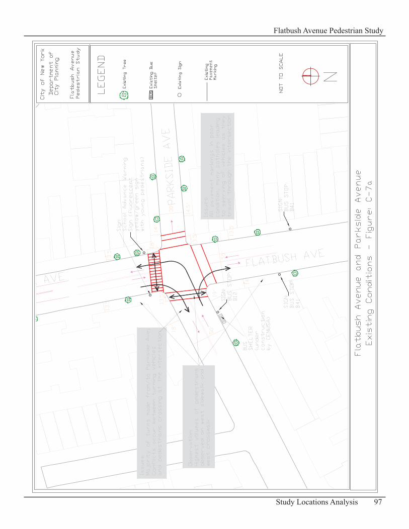
97Study Locations Analysis
Flatbush Avenue Pedestrian Study
98 Study Locations Analysis
Flatbush Avenue Pedestrian Study
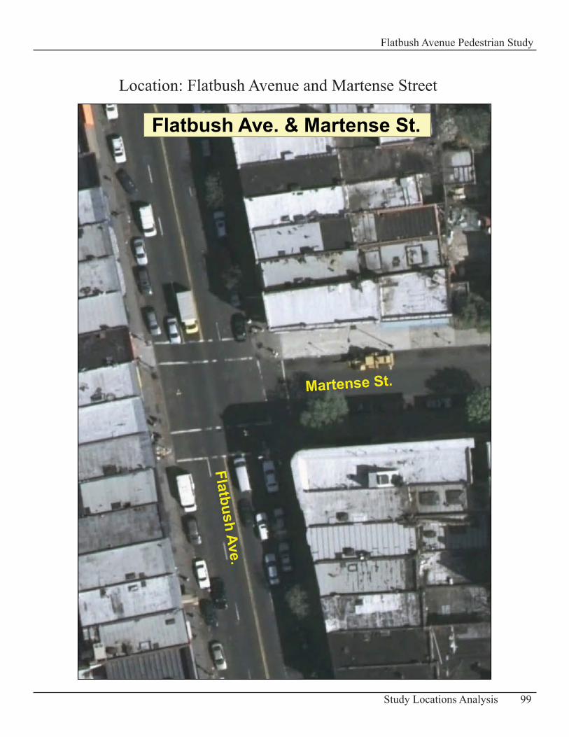
99Study Locations Analysis
Flatbush Avenue Pedestrian Study
Location: Flatbush Avenue and Martense Street
Flatbush Ave. & Martense St.
Flatbush Ave.
Martense St.
Intersection of Flatbush Avenue and Martense Street Description of Existing ConditionsThe intersection of Flatbush Avenue and Martense Street is a T-shaped intersection.
Flatbush Avenue is 55ft wide with two travel lanes in each direction of traffic.
Martense Street has a width of 35 ft with two-way vehicular traffic.
Vehicle volumes on Flatbush Avenue at this intersection are moderate but heavy at times. Traffic volumes on Martense Street are much lighter. Pedestrian volumes are light at this location.
Pedestrian Accident Data 2004 -20066 Pedestrian Accidents
Table: C-20 – Summary of Pedestrian Accidents
Accident Location Year Time Pedestrian ActionP e d e s t r i a n Location Vehicle Action
Martense St 10/7/2004 daylight crossing with signal at intersection not reported
Martense St 11/17/2004 daylight crossing with signal at intersection making a left turn
Martense St 2/27/2005 daylight crossing with signal at intersection making a left turn
Martense St 3/9/2005 night; snow, ice crossing with signal at intersection making a right turn
Martense St 6/2/2005 daylight crossing with signal at intersection going straight ahead
Martense St 11/12/2005 daylight crossing with signal at intersection not reported
100 Study Locations Analysis
Flatbush Avenue Pedestrian Study
Problems and OpportunitiesPedestrian/ Vehicle Conflicts • The situation at this intersection is similar to other intersections where conflicts occur with vehicles making turns and pedestrians crossing with the green light. Based on the pedestrian accident data from 2004 to 2006, six pedestrians were injured at the intersection as they were crossing with the traffic signal which indicates that the motorists involved in the accidents most likely did not yield to pedestrians at the intersection.
RecommendationsNew Signage• It is recommended to install at all corners of the intersection “Attention Drivers Yield to Pedestrians” signs (with graphics - see Appendix D-2) to get motorists to yield for crossing pedestrians and also to be more aware of the presence of pedestrians at this intersection.
Increase Enforcement• An increase in police presence on Flatbush Avenue is recommended to enforce observance of the New York State law which requires vehicles to yield to pedestrians legally using a marked crosswalk.
101Study Locations Analysis
Flatbush Avenue Pedestrian Study
102 Study Locations Analysis
Flatbush Avenue Pedestrian Study
103Study Locations Analysis
Flatbush Avenue Pedestrian Study

104 Study Locations Analysis
Flatbush Avenue Pedestrian Study
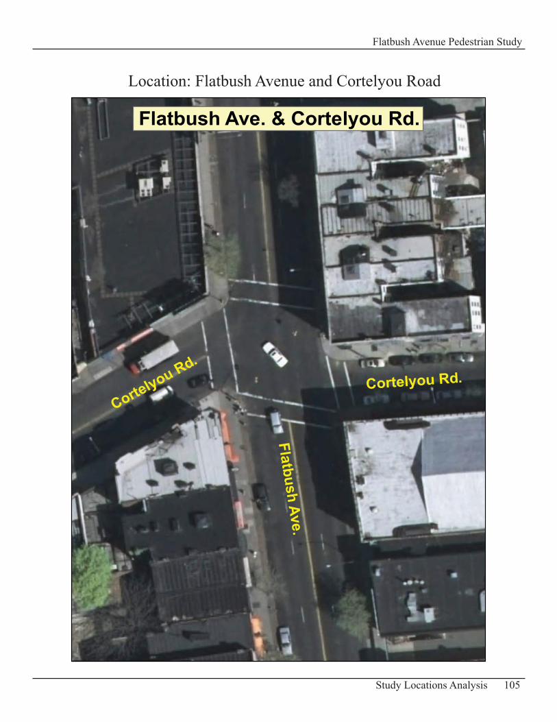
105Study Locations Analysis
Flatbush Avenue Pedestrian Study
Flatbush Ave. & Cortelyou Rd.
Flatbush Ave.
Cortelyou Rd.
Cortelyou Rd.
Location: Flatbush Avenue and Cortelyou Road
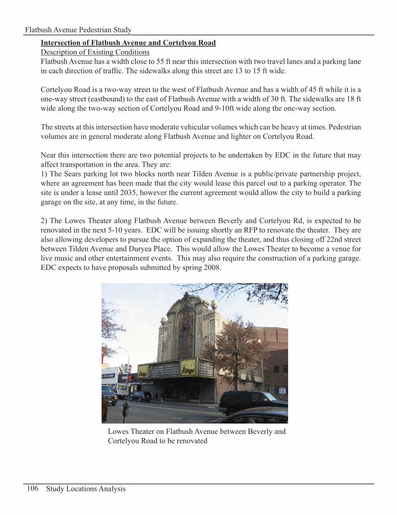
Intersection of Flatbush Avenue and Cortelyou RoadDescription of Existing ConditionsFlatbush Avenue has a width close to 55 ft near this intersection with two travel lanes and a parking lane in each direction of traffic. The sidewalks along this street are 13 to 15 ft wide.
Cortelyou Road is a two-way street to the west of Flatbush Avenue and has a width of 45 ft while it is a one-way street (eastbound) to the east of Flatbush Avenue with a width of 30 ft. The sidewalks are 18 ft wide along the two-way section of Cortelyou Road and 9-10ft wide along the one-way section.
The streets at this intersection have moderate vehicular volumes which can be heavy at times. Pedestrian volumes are in general moderate along Flatbush Avenue and lighter on Cortelyou Road.
Near this intersection there are two potential projects to be undertaken by EDC in the future that may affect transportation in the area. They are:1) The Sears parking lot two blocks north near Tilden Avenue is a public/private partnership project, where an agreement has been made that the city would lease this parcel out to a parking operator. The site is under a lease until 2035, however the current agreement would allow the city to build a parking garage on the site, at any time, in the future.
2) The Lowes Theater along Flatbush Avenue between Beverly and Cortelyou Rd, is expected to be renovated in the next 5-10 years. EDC will be issuing shortly an RFP to renovate the theater. They are also allowing developers to pursue the option of expanding the theater, and thus closing off 22nd street between Tilden Avenue and Duryea Place. This would allow the Lowes Theater to become a venue for live music and other entertainment events. This may also require the construction of a parking garage. EDC expects to have proposals submitted by spring 2008.
106 Study Locations Analysis
Flatbush Avenue Pedestrian Study
Lowes Theater on Flatbush Avenue between Beverly and Cortelyou Road to be renovated
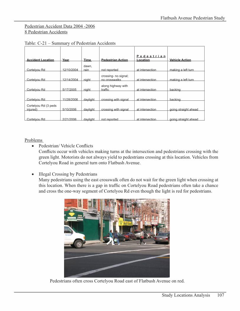
Pedestrian Accident Data 2004 -20068 Pedestrian Accidents
Table: C-21 – Summary of Pedestrian Accidents
Accident Location Year Time Pedestrian ActionP e d e s t r i a n Location Vehicle Action
Cortelyou Rd 12/10/2004dawn, rain not reported at intersection making a left turn
Cortelyou Rd 12/14/2004 nightcrossing- no signal; no crosswalks at intersection making a left turn
Cortelyou Rd 5/17/2005 nightalong highway with traffic at intersection backing
Cortelyou Rd 11/28/2006 daylight crossing with signal at intersection backing
Cortelyou Rd (3 peds injured) 5/10/2006 daylight crossing with signal at intersection going straight ahead
Cortelyou Rd 2/21/2006 daylight not reported at intersection going straight ahead
Problems Pedestrian/ Vehicle Conflicts • Conflicts occur with vehicles making turns at the intersection and pedestrians crossing with the green light. Motorists do not always yield to pedestrians crossing at this location. Vehicles from Cortelyou Road in general turn onto Flatbush Avenue.
Illegal Crossing by Pedestrians • Many pedestrians using the east crosswalk often do not wait for the green light when crossing at this location. When there is a gap in traffic on Cortelyou Road pedestrians often take a chance and cross the one-way segment of Cortelyou Rd even though the light is red for pedestrians.
107Study Locations Analysis
Flatbush Avenue Pedestrian Study
Pedestrians often cross Cortelyou Road east of Flatbush Avenue on red.
Pavement Conditions• Drivers tried to avoid potholes at this intersection by swerving around them as they traveled through the intersection. This can be an unsafe situation for pedestrians because drivers can swerve into the path of pedestrians crossing at the time.
RecommendationsInstall a Leading Pedestrian Interval (LPI) • For pedestrians crossing Flatbush Avenue it is recommended to install a Leading Pedestrian Interval Phase (LPI = 5 seconds). It provides pedestrians with a head start before the vehicular green phase starts and allows them to clear the intersection much quicker in order to allow vehicles to make their turns with fewer conflicts. At the same time pedestrians are more visible to motorists who are more likely to yield to pedestrians.
Signage • As a recommendation signage can be used to increase traffic safety at the intersection. Install a “Cross on Green Light Only” sign (MUTCD, R10-1 sign; see Appendix D-2: Standards for Signs Recommended) at the east crosswalk. This encourages pedestrians to wait for the green light when crossing at this location. Also install signs oriented towards motorists at this intersection at the corners requesting “Turning Vehicles to Yield to Pedestrians”.
Improve Pavement Conditions • Repair the roadway at this intersection and fill in the potholes as a recommendation in order to reduce the swerving movement of vehicles as they travel through the intersection.
108 Study Locations Analysis
Flatbush Avenue Pedestrian Study
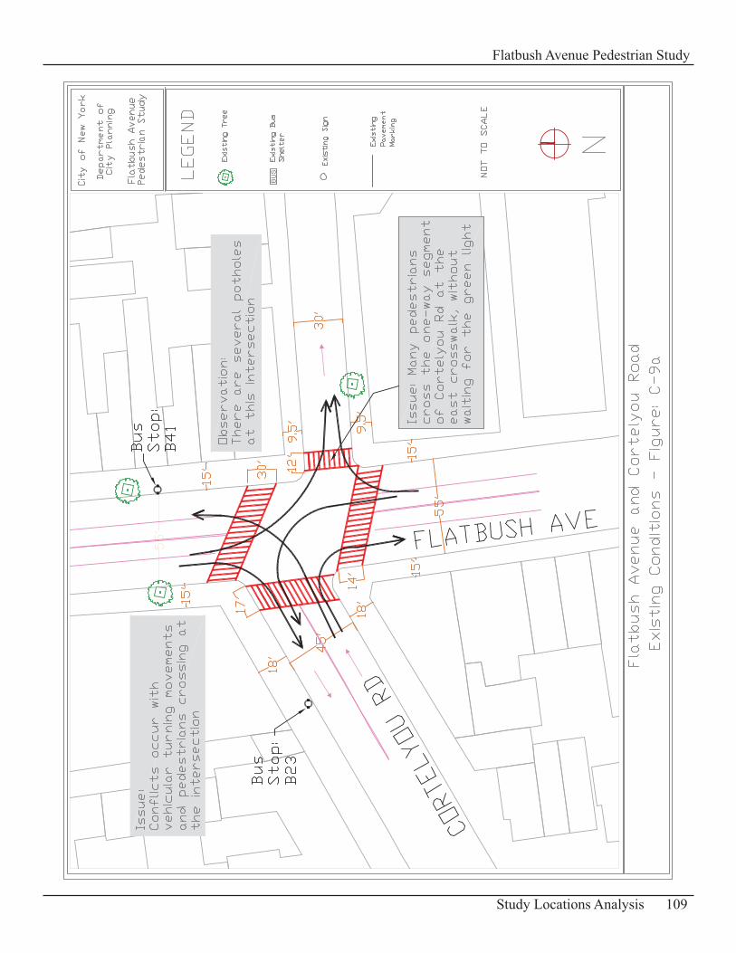
109Study Locations Analysis
Flatbush Avenue Pedestrian Study
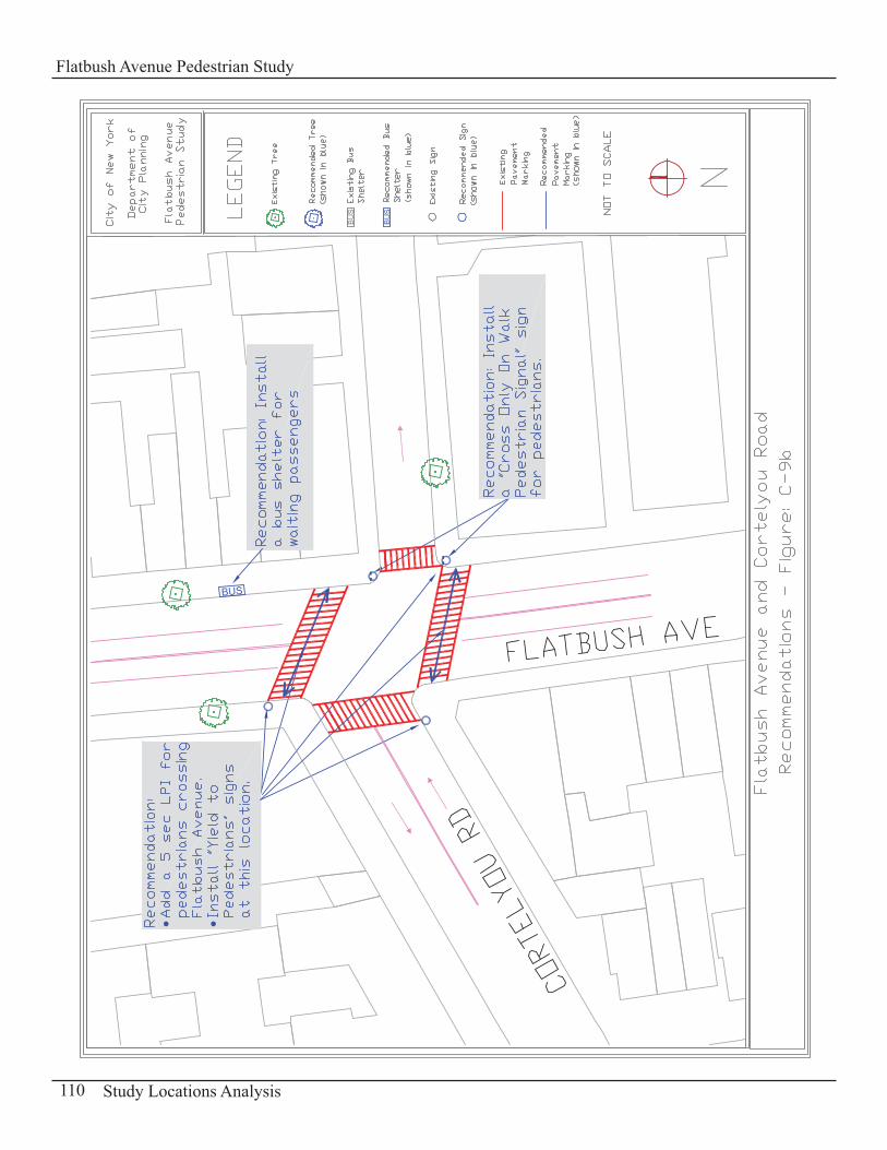
110 Study Locations Analysis
Flatbush Avenue Pedestrian Study
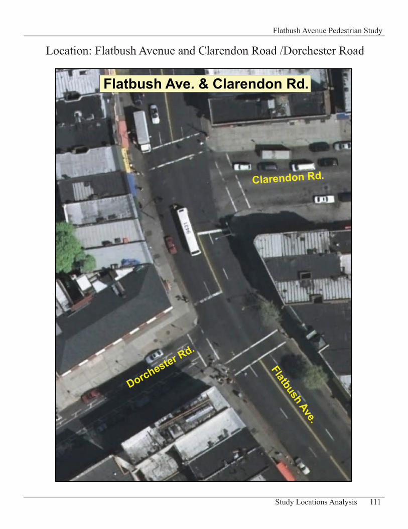
111Study Locations Analysis
Flatbush Avenue Pedestrian Study
Location: Flatbush Avenue and Clarendon Road /Dorchester Road
Flatbush Ave. & Clarendon Rd.
Flatbush Ave.
Clarendon Rd.
Dorchester Rd.
Intersection of Flatbush Avenue and Clarendon Road/Dorchester RoadDescription of Existing ConditionsFlatbush Avenue is 55 ft wide approximately at this location, has two travel lanes and a parking lane in each direction of traffic. The sidewalks along this street are 14 – 15 ft wide.
Clarendon Road a two-way street to the east of Flatbush Avenue, is 52 ft wide while Dorchester Road a one-way street on the west side of Flatbush Avenue is 35 ft wide with traffic calming markings placed between the travel lanes and the parking lane. The sidewalks on Clarendon and Dorchester Roads are wide for this area of Brooklyn with dimensions of 22 – 23 ft.
Vehicle volumes on Flatbush Avenue at this intersection can get heavy at times. The intersecting streets have moderate vehicle volumes which can be light at times. Pedestrian volumes are light in general in this area.
Two signs near the “Stop bar” at the intersection inform pedestrians not to cross at that particular location: “No Ped Crossing Use Crosswalks”.
Pedestrian Accident Data 2004 -20065 Pedestrian Accidents
Table: C-22 – Summary of Pedestrian Accidents
Accident Location Year Time Pedestrian ActionP e d e s t r i a n Location Vehicle Action
Clarendon Rd 7/31/2004 daylight going north at intersection going straight ahead
Clarendon Rd 5/21/2005 daylight, rain crossing against signal at intersection going straight ahead
Clarendon Rd 5/1/2005 daylight, rain crossing against signal at intersection going straight ahead
Clarendon Rd 3/21/2005 daylight crossing with signal at intersection going straight ahead
Clarendon Rd 1/3/2006 daylight, rain crossing with signal at intersection making a left turn
Problems Pedestrians Crossing at “Stop Bar” locations• Clarendon Road to the east of Flatbush Avenue changes to Dorchester Road west of Flatbush Avenue. These two streets or segments do not align and in between the two segments stop bars are placed to stop vehicles as they arrive at the intersection. However pedestrians cross Flatbush Avenue at that particular spot when the light turns green which creates a dangerous and unsafe situation for pedestrians. Drivers going westbound on Clarendon Road and continuing onto Dorchester Road do not expect pedestrians to be crossing at that location especially when a right turn is permitted on red at Dorchester Road. There are signs to inform pedestrians not to cross at that particular location: “No Ped Crossing Use Crosswalks”. But these signs are smaller than the existing regulatory signs posted and are often not noticeable to pedestrians arriving at the intersection because of their size and location.
112 Study Locations Analysis
Flatbush Avenue Pedestrian Study
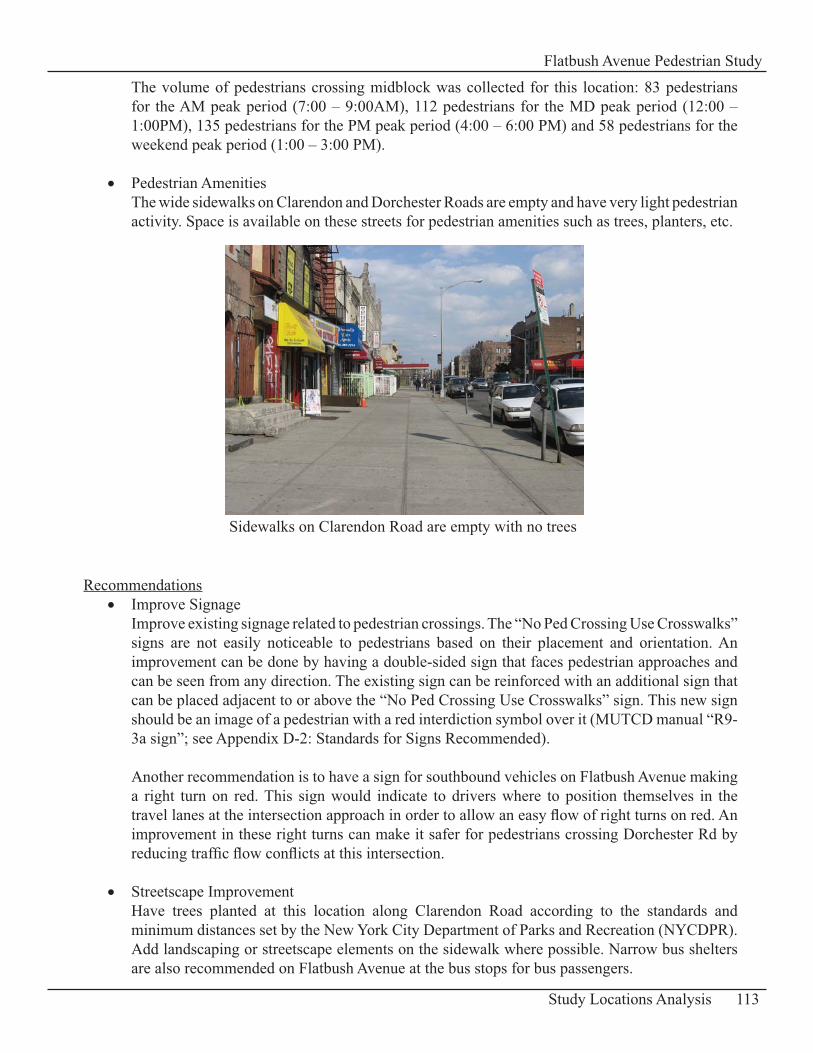
The volume of pedestrians crossing midblock was collected for this location: 83 pedestrians for the AM peak period (7:00 – 9:00AM), 112 pedestrians for the MD peak period (12:00 – 1:00PM), 135 pedestrians for the PM peak period (4:00 – 6:00 PM) and 58 pedestrians for the weekend peak period (1:00 – 3:00 PM).
Pedestrian Amenities• The wide sidewalks on Clarendon and Dorchester Roads are empty and have very light pedestrian activity. Space is available on these streets for pedestrian amenities such as trees, planters, etc.
RecommendationsImprove Signage• Improve existing signage related to pedestrian crossings. The “No Ped Crossing Use Crosswalks” signs are not easily noticeable to pedestrians based on their placement and orientation. An improvement can be done by having a double-sided sign that faces pedestrian approaches and can be seen from any direction. The existing sign can be reinforced with an additional sign that can be placed adjacent to or above the “No Ped Crossing Use Crosswalks” sign. This new sign should be an image of a pedestrian with a red interdiction symbol over it (MUTCD manual “R9-3a sign”; see Appendix D-2: Standards for Signs Recommended).
Another recommendation is to have a sign for southbound vehicles on Flatbush Avenue making a right turn on red. This sign would indicate to drivers where to position themselves in the travel lanes at the intersection approach in order to allow an easy flow of right turns on red. An improvement in these right turns can make it safer for pedestrians crossing Dorchester Rd by reducing traffic flow conflicts at this intersection.
Streetscape Improvement• Have trees planted at this location along Clarendon Road according to the standards and minimum distances set by the New York City Department of Parks and Recreation (NYCDPR). Add landscaping or streetscape elements on the sidewalk where possible. Narrow bus shelters are also recommended on Flatbush Avenue at the bus stops for bus passengers.
113Study Locations Analysis
Flatbush Avenue Pedestrian Study
Sidewalks on Clarendon Road are empty with no trees
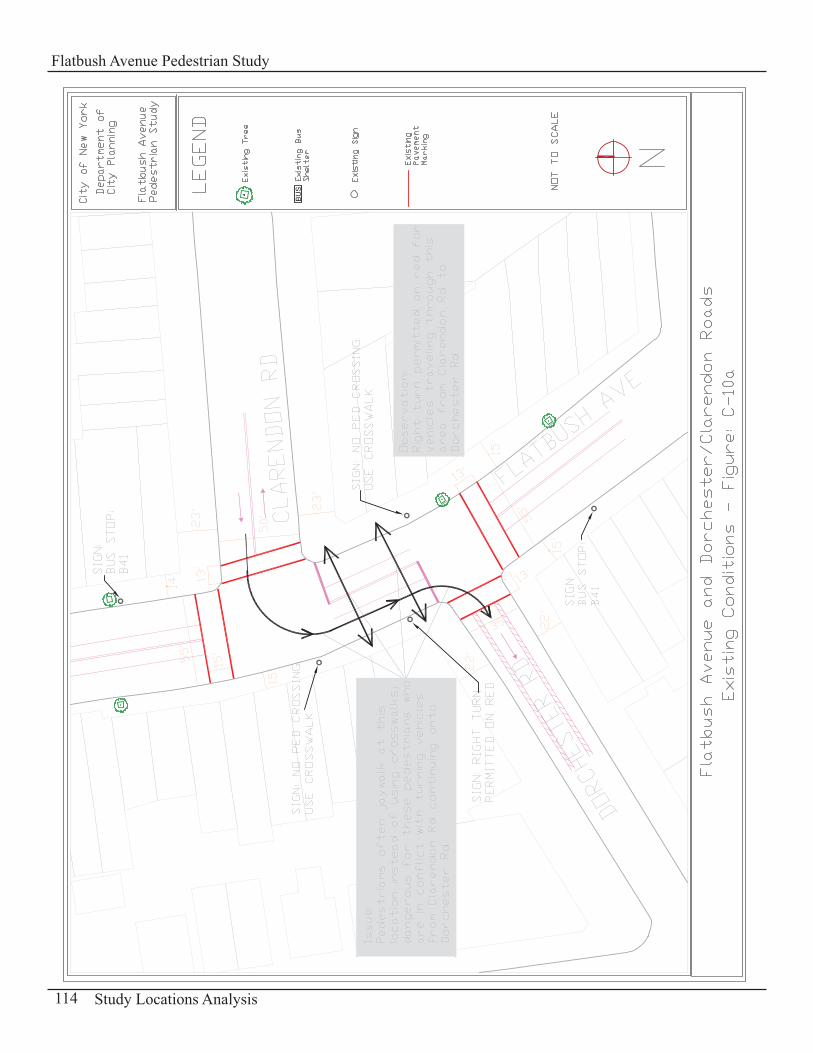
114 Study Locations Analysis
Flatbush Avenue Pedestrian Study
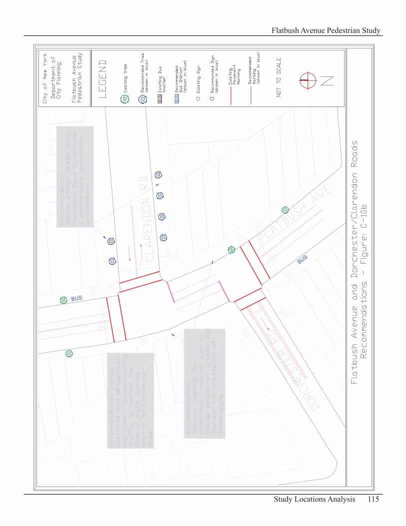
115Study Locations Analysis
Flatbush Avenue Pedestrian Study

116 Study Locations Analysis
Flatbush Avenue Pedestrian Study
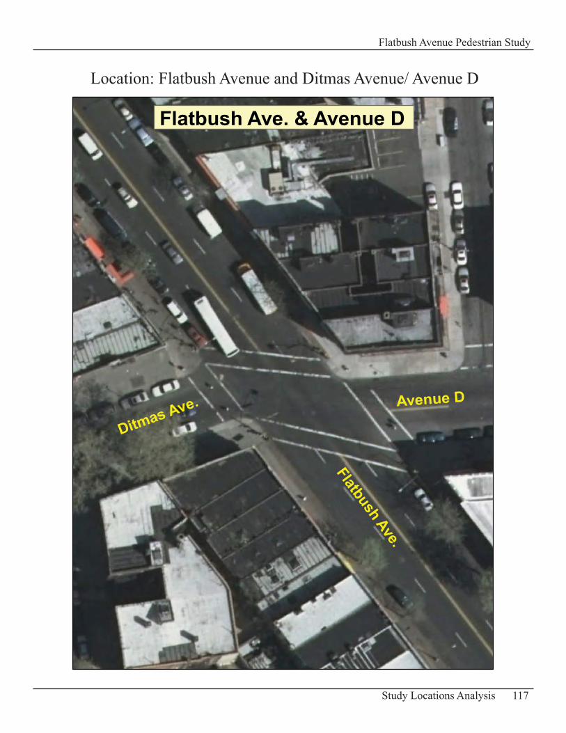
117Study Locations Analysis
Flatbush Avenue Pedestrian Study
Flatbush Ave. & Avenue D
Flatbush Ave.
Avenue D
Ditmas Ave.
Location: Flatbush Avenue and Ditmas Avenue/ Avenue D
Intersection of Flatbush Avenue and Ditmas Avenue/ Avenue DDescription of Existing ConditionsFlatbush Avenue is about 55 ft wide in this part of the study area. It also has two travel lanes and a parking lane in each direction of traffic. The sidewalks along this major street are 14 ft wide.
The intersecting street at this location has two different names: Ditmas Avenue/ Avenue D. Ditmas Avenue is located to the west of Flatbush Avenue with a width of 35 ft and has wide sidewalks, 22 - 23 ft wide. Avenue D is located to the east of Flatbush and is 45 ft wide. The sidewalks are 18 ft wide. These streets are both two-way streets with one travel lane in each direction of traffic.
Based on field observation, significant vehicular volumes exist at this intersection with higher volumes on Flatbush Avenue. Pedestrian volumes at this location are light.
Pedestrian Accident Data 2004 -20068 Pedestrian Accidents
Table: C-23 – Summary of Pedestrian Accidents
Accident Location Year Time Pedestrian ActionP e d e s t r i a n Location Vehicle Action
Ave D/ Ditmas Ave 11/21/2004 nightalong highway with traffic at intersection going straight ahead
Ave D/ Ditmas Ave 3/10/2005 daylightcrossing- no signal; no crosswalks at intersection making a right turn
Ave D/ Ditmas Ave 11/29/2005 night, rain crossing with signal at intersection making a left turn
Ave D/ Ditmas Ave (3 peds injured) 2/27/2006 daylight crossing with signal at intersection making a left turn
Ave D/ Ditmas Ave 9/19/2006 daylight crossing with signal at intersection going straight ahead
Ave D/ Ditmas Ave 12/27/2006 night crossing with signal at intersection making a left turn
Problems and Opportunities
Vehicles and Crosswalks• The awkward shape of the intersection often has vehicles on Flatbush Avenue waiting for the green light partially in the crosswalk which is at an angle. This creates conflicts between drivers and pedestrians and reduces visibility due to a shorter sight distance at the intersection for the driver.
118 Study Locations Analysis
Flatbush Avenue Pedestrian Study
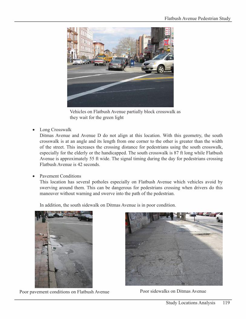
Long Crosswalk• Ditmas Avenue and Avenue D do not align at this location. With this geometry, the south crosswalk is at an angle and its length from one corner to the other is greater than the width of the street. This increases the crossing distance for pedestrians using the south crosswalk, especially for the elderly or the handicapped. The south crosswalk is 87 ft long while Flatbush Avenue is approximately 55 ft wide. The signal timing during the day for pedestrians crossing Flatbush Avenue is 42 seconds.
Pavement Conditions• This location has several potholes especially on Flatbush Avenue which vehicles avoid by swerving around them. This can be dangerous for pedestrians crossing when drivers do this maneuver without warning and swerve into the path of the pedestrian.
In addition, the south sidewalk on Ditmas Avenue is in poor condition.
119Study Locations Analysis
Flatbush Avenue Pedestrian Study
Vehicles on Flatbush Avenue partially block crosswalk as they wait for the green light
Poor sidewalks on Ditmas Avenue Poor pavement conditions on Flatbush Avenue
Pedestrian Amenities• There are a few trees on Flatbush Avenue. Ditmas Avenue/Avenue D corridor lacks also in trees near this part of Flatbush Avenue.
RecommendationsInstall a Stop bar • It is recommended to install a stop bar or stop line about 15 ft from each crosswalk located on Flatbush Avenue to facilitate eastbound and westbound crossings. This reduces conflicts between pedestrians and motorists, allows them to have a better view of each other at the intersection and improves sight distances for the motorist. It will also make left turning movements easier from Ditmas Avenue/ Avenue D and improve safety for crossing pedestrians.
Install a Leading Pedestrian Interval (LPI) • Install a Leading Pedestrian Interval Phase (LPI = 5 seconds) for pedestrians crossing Flatbush Avenue. It provides pedestrians with a head start before vehicles travel through the intersection and reduces conflicts with turning vehicles. Motorists are more likely with this phase to yield to pedestrians.
Repair Pavement and Sidewalk • Repair and resurface the pavement at this location in order to reduce swerving movements by drivers as they travel through the intersection. The addition of concrete bus pads can help eliminate bumps created by buses coming in and out of the bus stop.
Rebuild the south sidewalk on Ditmas Avenue as an improvement to the pedestrian’s environment.
Streetscape improvement• In order to enhance the pedestrian environment install bus shelters at the bus stops based on NYDOT’s guidelines and standards for placement of street furniture and plant a few trees where possible and adequate at this location (see Appendix D-3: Standards for Bus Shelters and Appendix D-4: Standards for Trees for more details).
120 Study Locations Analysis
Flatbush Avenue Pedestrian Study
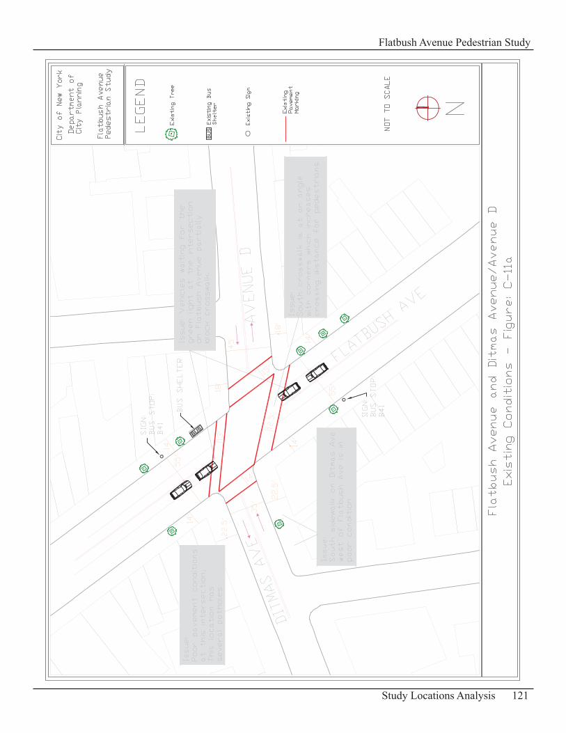
121Study Locations Analysis
Flatbush Avenue Pedestrian Study
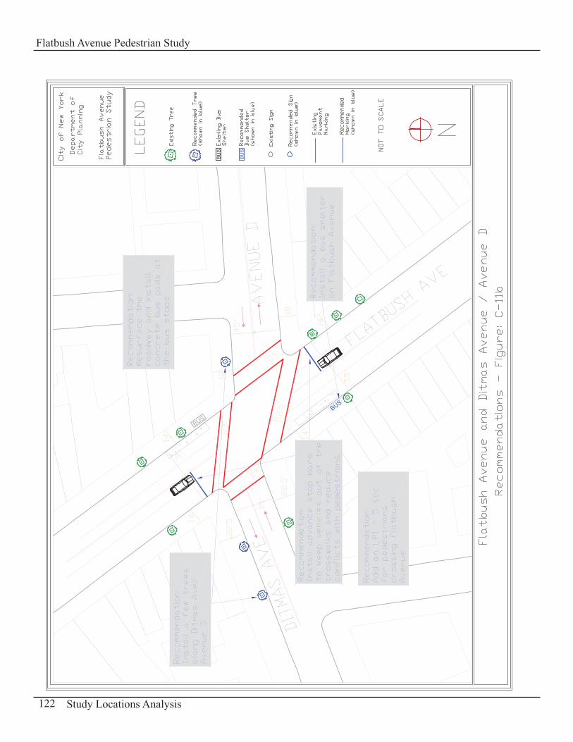
122 Study Locations Analysis
Flatbush Avenue Pedestrian Study
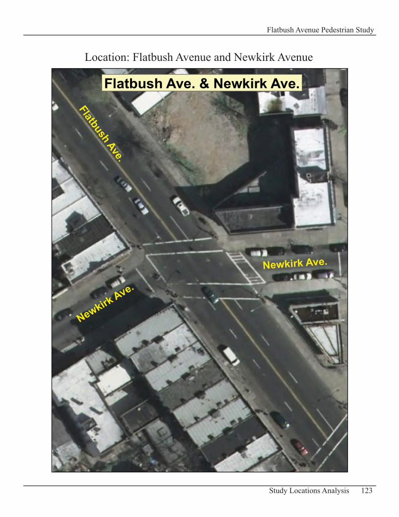
123Study Locations Analysis
Flatbush Avenue Pedestrian Study
Flatbush Ave. & Newkirk Ave.
Flatbush Ave.Newkirk Ave.
Newkirk Ave.
Location: Flatbush Avenue and Newkirk Avenue
Intersection of Flatbush Avenue and Newkirk Avenue Description of Existing ConditionsThe width of Flatbush Avenue is 55 ft at this location with two travel lanes in each direction of traffic. Newkirk Avenue is a one-way street with a width of 25 ft to the west of Flatbush Avenue and 30 ft to the east of this avenue. Vehicular traffic travels eastbound on this street.
Vehicle volumes on Flatbush Avenue are generally heavy. Newkirk Avenue has moderate vehicle volumes which can be light at times. Pedestrian volumes are moderate to light at this location.
Pedestrian Accident Data 2004 -20065 Pedestrian Accidents
Table: C-24 – Summary of Pedestrian Accidents
Accident Location Year Time Pedestrian ActionP e d e s t r i a n Location Vehicle Action
Newkirk Ave 12/17/2004 daylight crossing with signal at intersection going straight ahead
Newkirk Ave 5/11/2005 daylightcrossing- no signal; no crosswalks at intersection going straight ahead
Newkirk Ave 6/29/2006 daylight crossing with signal at intersection making a left turn
Newkirk Ave 8/23/2006 daylight crossing against signal at intersection going straight ahead
Newkirk Ave 2/13/2006daylight, snow/ice surface getting on/off vehicle at intersection going straight ahead
Problems Pedestrian/ Vehicle Conflicts • Similar to other intersections in the city there are conflicts with vehicles making a turn and pedestrians crossing with the green light. Most of the turning movements observed at this location was made from Newkirk Avenue onto Flatbush Avenue.
Pavement Conditions• The east crosswalk markings along Newkirk Avenue and the pavement at this intersection are in poor condition.
124 Study Locations Analysis
Flatbush Avenue Pedestrian Study
RecommendationsAdditional Signage• It is recommended to install at the southwest corner at the level of the stop bar a warning sign “Attention Drivers Yield to Pedestrians” for eastbound traffic making a turn onto Flatbush Avenue. Most of the turns are made from Newkirk Avenue and this warning sign can help modify motorists turns and improve safety for pedestrians crossing Flatbush Avenue. Improve Pavement Conditions• Restripe markings at this intersection, particularly the east crosswalk and repave the roadway surface.
125Study Locations Analysis
Flatbush Avenue Pedestrian Study
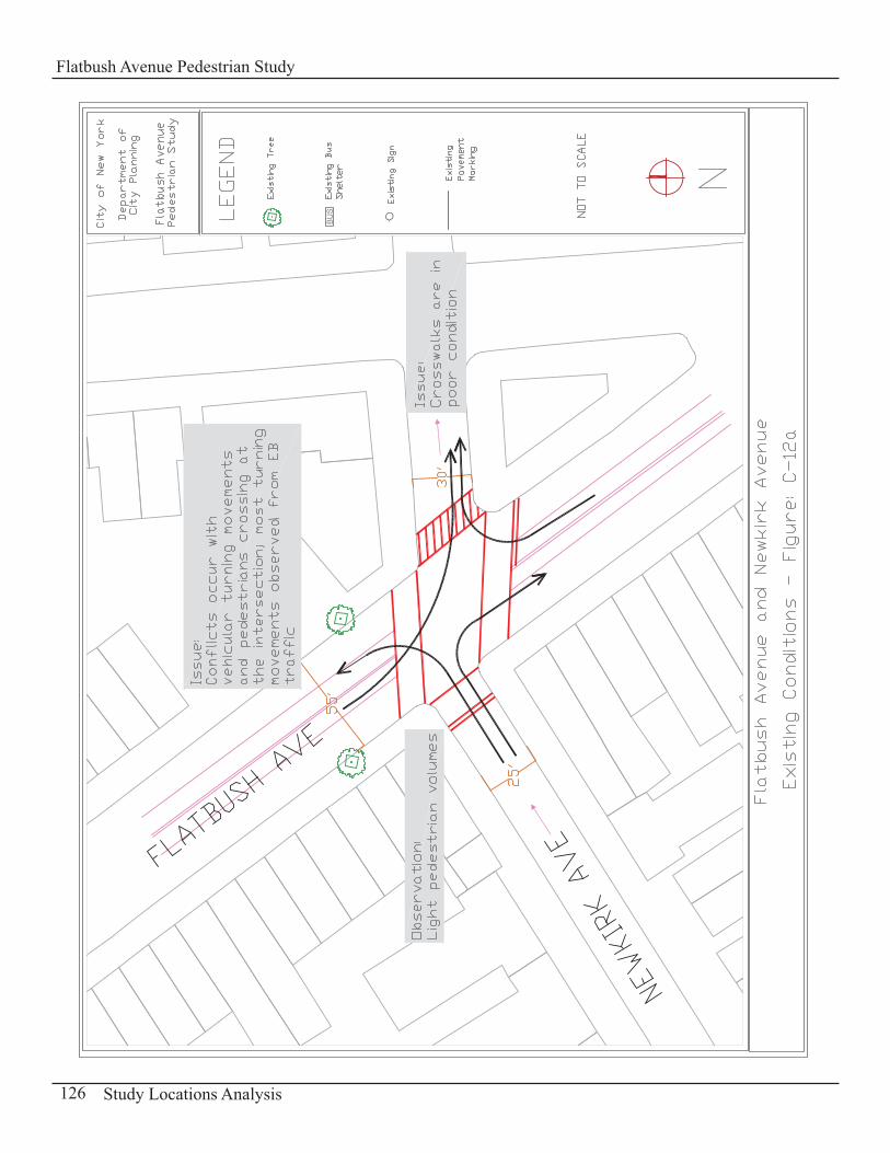
126 Study Locations Analysis
Flatbush Avenue Pedestrian Study
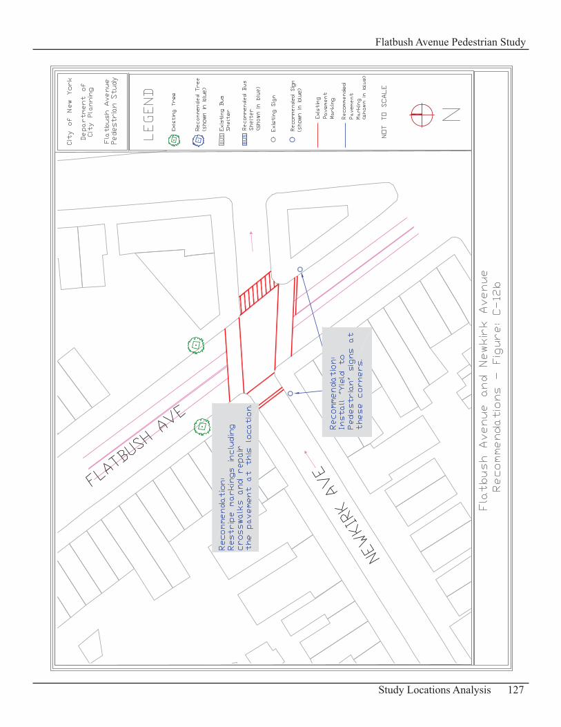
127Study Locations Analysis
Flatbush Avenue Pedestrian Study

128 Study Locations Analysis
Flatbush Avenue Pedestrian Study
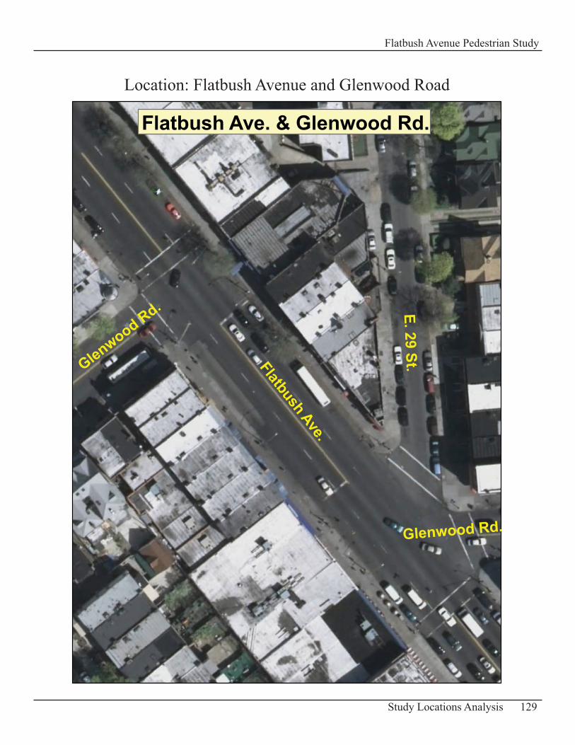
129Study Locations Analysis
Flatbush Avenue Pedestrian Study
Flatbush Ave. & Glenwood Rd.
Flatbush Ave.
Glenwood Rd.
Glenwood Rd.
E. 29 St.
Location: Flatbush Avenue and Glenwood Road
Intersection of Flatbush Avenue and Glenwood RoadDescription of Existing ConditionsFlatbush Avenue is about 60 ft wide near Glenwood Road and has two travel lanes and a parking lane in each direction of traffic. The sidewalks along this major arterial are 17 –18 ft wide.
Glenwood Road is segmented and does not align as it intersects Flatbush Avenue. It is a two-way street with one travel lane in each direction of traffic and has a width of 40 ft. The sidewalks on Glenwood Road are 17 -18 ft wide.
Vehicle volumes are observed to be heavy at times in this part of Flatbush Avenue. Glenwood Road has moderate vehicle volumes which can be heavy at times especially during the evening peak hours. In general pedestrian volumes are moderate.
Two signs near the “Stop bar” at the intersection (one at each stop bar location) inform pedestrians not to cross at that particular location: “No Ped Crossing Use Crosswalks”.
130 Study Locations Analysis
Flatbush Avenue Pedestrian Study
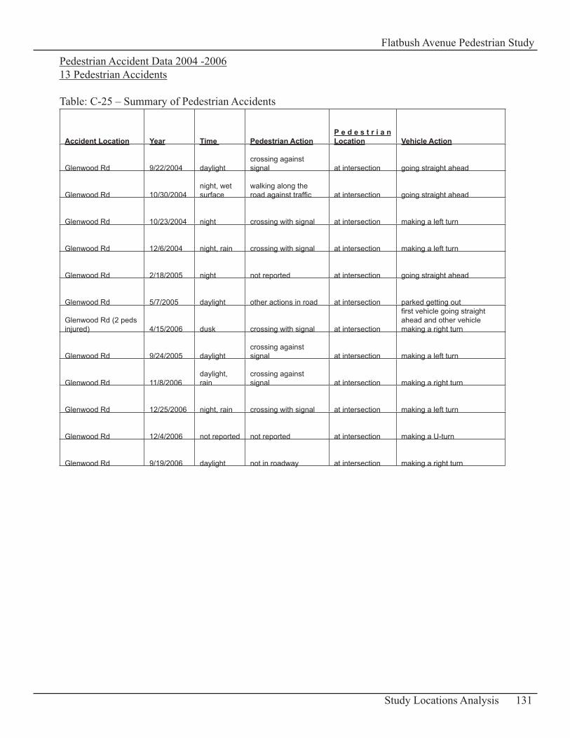
Pedestrian Accident Data 2004 -200613 Pedestrian Accidents
Table: C-25 – Summary of Pedestrian Accidents
Accident Location Year Time Pedestrian ActionP e d e s t r i a n Location Vehicle Action
Glenwood Rd 9/22/2004 daylightcrossing against signal at intersection going straight ahead
Glenwood Rd 10/30/2004night, wet surface
walking along the road against traffic at intersection going straight ahead
Glenwood Rd 10/23/2004 night crossing with signal at intersection making a left turn
Glenwood Rd 12/6/2004 night, rain crossing with signal at intersection making a left turn
Glenwood Rd 2/18/2005 night not reported at intersection going straight ahead
Glenwood Rd 5/7/2005 daylight other actions in road at intersection parked getting out
Glenwood Rd (2 peds injured) 4/15/2006 dusk crossing with signal at intersection
first vehicle going straight ahead and other vehicle making a right turn
Glenwood Rd 9/24/2005 daylightcrossing against signal at intersection making a left turn
Glenwood Rd 11/8/2006daylight, rain
crossing against signal at intersection making a right turn
Glenwood Rd 12/25/2006 night, rain crossing with signal at intersection making a left turn
Glenwood Rd 12/4/2006 not reported not reported at intersection making a U-turn
Glenwood Rd 9/19/2006 daylight not in roadway at intersection making a right turn
131Study Locations Analysis
Flatbush Avenue Pedestrian Study
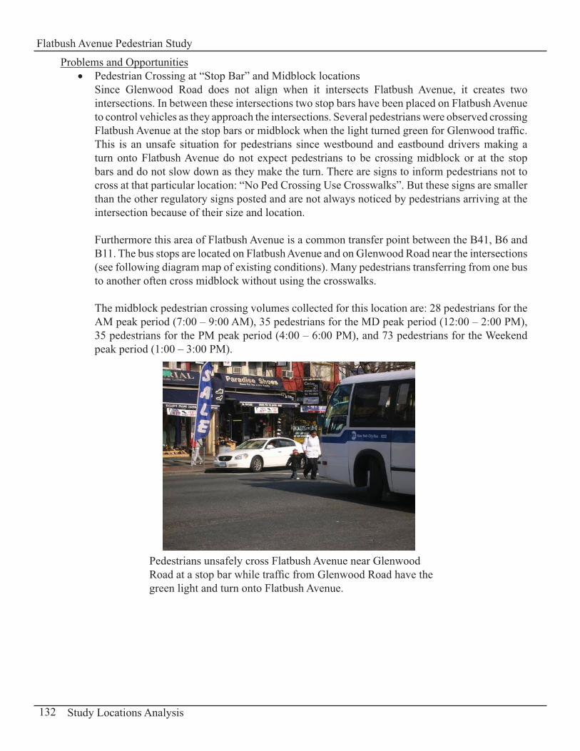
Problems and OpportunitiesPedestrian Crossing at “Stop Bar” and Midblock locations • Since Glenwood Road does not align when it intersects Flatbush Avenue, it creates two intersections. In between these intersections two stop bars have been placed on Flatbush Avenue to control vehicles as they approach the intersections. Several pedestrians were observed crossing Flatbush Avenue at the stop bars or midblock when the light turned green for Glenwood traffic. This is an unsafe situation for pedestrians since westbound and eastbound drivers making a turn onto Flatbush Avenue do not expect pedestrians to be crossing midblock or at the stop bars and do not slow down as they make the turn. There are signs to inform pedestrians not to cross at that particular location: “No Ped Crossing Use Crosswalks”. But these signs are smaller than the other regulatory signs posted and are not always noticed by pedestrians arriving at the intersection because of their size and location.
Furthermore this area of Flatbush Avenue is a common transfer point between the B41, B6 and B11. The bus stops are located on Flatbush Avenue and on Glenwood Road near the intersections (see following diagram map of existing conditions). Many pedestrians transferring from one bus to another often cross midblock without using the crosswalks.
The midblock pedestrian crossing volumes collected for this location are: 28 pedestrians for the AM peak period (7:00 – 9:00 AM), 35 pedestrians for the MD peak period (12:00 – 2:00 PM), 35 pedestrians for the PM peak period (4:00 – 6:00 PM), and 73 pedestrians for the Weekend peak period (1:00 – 3:00 PM).
132 Study Locations Analysis
Flatbush Avenue Pedestrian Study
Pedestrians unsafely cross Flatbush Avenue near Glenwood Road at a stop bar while traffic from Glenwood Road have the green light and turn onto Flatbush Avenue.
Traffic congestion and delays• Traffic congestion and delays occur at times on Flatbush Avenue at Glenwood Road and are often caused by double parking in the southbound lanes of trucks and vans loading /unloading merchandise. Several jaywalkers were observed during these delays crossing Flatbush Avenue at midblock locations north and south of Glenwood Road.
Pavement Conditions• The pavement in this section of the study area is in poor condition with uneven segments. The north sidewalk of Glenwood Rd (segment south of E 29th Street) is cracked and uneven particularly near Flatbush Avenue.
RecommendationsImprove Pedestrian Crossing• The existing signs “No Ped Crossing Use Crosswalks” are not very useful based on their placement and orientation. As a recommendation, make each sign a double-sided sign that can be seen from both directions as you approach the midblock location. Have an additional sign put up adjacent to or above the “No Ped Crossing Use Crosswalks” sign. This sign should be an image of a pedestrian with a red interdiction symbol over it (MUTCD manual “R9-3a” sign; see Appendix D-2: Standards for Signs Recommended). It reinforces the first sign and displays graphically that it is prohibited for pedestrians to cross the roadway at an undesirable location where crossing is not designated.
Bus Stop Relocation• An additional recommendation is to move the B41 northbound bus stop north of the existing crosswalk with the cooperation of the Metropolitan Transit Authority (MTA). Placing the bus stop at this new location will make it more convenient for bus passengers transferring to/from the B41 bus. The bus stop would be closer to the east - west crosswalk as bus riders cross Flatbush Avenue to transfer from one bus line to the other. Appropriate placement of the bus stop at this intersection is key to pedestrian safety (See following map of recommendations). Signage• As a proposal to minimize double parking on the west side of Flatbush Avenue, loading and unloading zones should be provided for trucks and vans making deliveries to businesses in the area. In return it can discourage pedestrian jaywalking at this location when vehicular traffic delays and gaps are minimized. The loading zone can be provided by removing the “No Parking” signs and metered parking located south of the bus stop and replace them with “No Standing Anytime, except for Deliveries” signs (See following map of recommendations).
An increase in enforcement presence can help cut back on illegal double parking in the area.
Improve Pavement Conditions • Repair the pavement at this intersection including the north sidewalk of the segment of Glenwood Road south of E 29th Street in order to enhance the street environment for pedestrians walking in this area.
133Study Locations Analysis
Flatbush Avenue Pedestrian Study
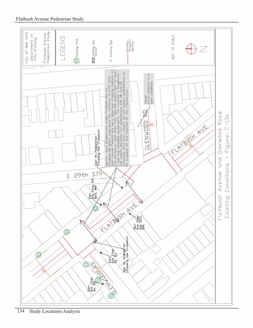
134 Study Locations Analysis
Flatbush Avenue Pedestrian Study
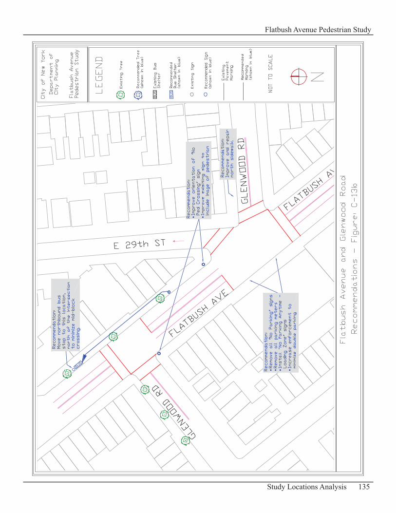
135Study Locations Analysis
Flatbush Avenue Pedestrian Study

136 Study Locations Analysis
Flatbush Avenue Pedestrian Study
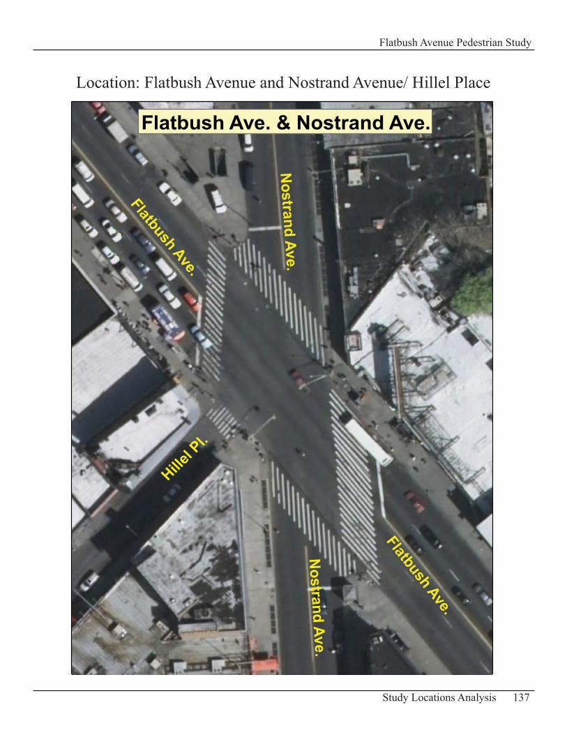
137Study Locations Analysis
Flatbush Avenue Pedestrian Study
Flatbush Ave. & Nostrand Ave.
Flatbush Ave.
Nostrand Ave.
Hillel P
l.
Nostrand Ave.
Flatbush Ave.
Location: Flatbush Avenue and Nostrand Avenue/ Hillel Place
Intersection of Flatbush Avenue and Nostrand Avenue/ Hillel PlaceDescription of Existing ConditionsThis is a major intermodal transfer location where hundreds of pedestrians travel through to get to/from subway trains and buses. Brooklyn College is one of the major generators of pedestrian traffic in the area.
At this location two major arterials intersect at an awkward angle Flatbush Avenue and Nostrand Avenue. A smaller street, Hillel Place, ends at this intersection.
Flatbush Avenue is about 65 ft wide at this location with two travel lanes in each direction of traffic. The sidewalks along this major street are 17 to 18 ft wide.
Nostrand Avenue at this intersection is 45 ft wide and is a two-way street with one travel lane in each direction of traffic. Its sidewalks measure 17 to 18 ft wide.
Hillel Place is 25 ft wide. Its sidewalks are 12 - 13 ft wide.
Vehicle and pedestrian volumes are usually heavy throughout the day on Flatbush and Nostrand Avenues. Traffic on Hillel Place is usually light, but pedestrian traffic get heavier at the end or beginning of classes when groups of students walk from/to the Brooklyn College campus.
This intersection is one of the few in New York City with a “Barnes Dance” – All Walk Phase where all pedestrians cross all streets at the same time at any crosswalks or diagonally. The length of the “all pedestrian phase” is about 25 -31 seconds depending on the time of the day.
138 Study Locations Analysis
Flatbush Avenue Pedestrian Study
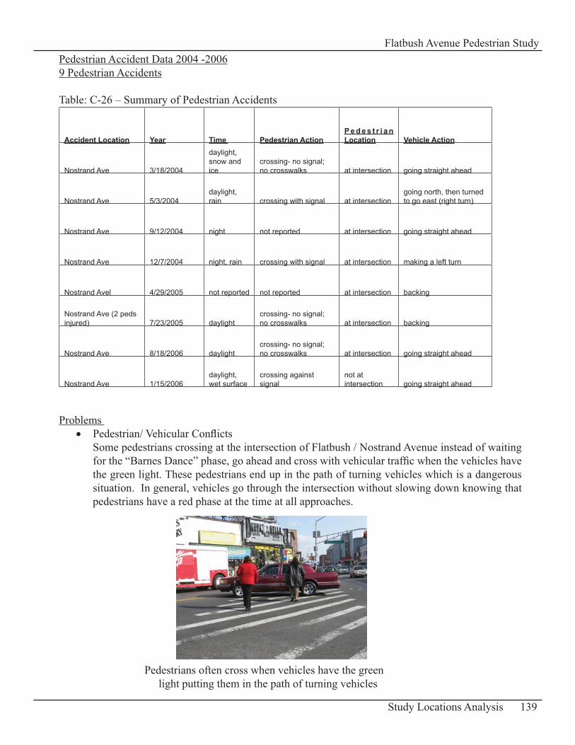
Pedestrian Accident Data 2004 -20069 Pedestrian Accidents
Table: C-26 – Summary of Pedestrian Accidents
Accident Location Year Time Pedestrian ActionP e d e s t r i a n Location Vehicle Action
Nostrand Ave 3/18/2004
daylight, snow and ice
crossing- no signal; no crosswalks at intersection going straight ahead
Nostrand Ave 5/3/2004daylight, rain crossing with signal at intersection
going north, then turned to go east (right turn)
Nostrand Ave 9/12/2004 night not reported at intersection going straight ahead
Nostrand Ave 12/7/2004 night, rain crossing with signal at intersection making a left turn
Nostrand Avel 4/29/2005 not reported not reported at intersection backing
Nostrand Ave (2 peds injured) 7/23/2005 daylight
crossing- no signal; no crosswalks at intersection backing
Nostrand Ave 8/18/2006 daylightcrossing- no signal; no crosswalks at intersection going straight ahead
Nostrand Ave 1/15/2006daylight, wet surface
crossing against signal
not at intersection going straight ahead
Problems Pedestrian/ Vehicular Conflicts • Some pedestrians crossing at the intersection of Flatbush / Nostrand Avenue instead of waiting for the “Barnes Dance” phase, go ahead and cross with vehicular traffic when the vehicles have the green light. These pedestrians end up in the path of turning vehicles which is a dangerous situation. In general, vehicles go through the intersection without slowing down knowing that pedestrians have a red phase at the time at all approaches.
139Study Locations Analysis
Flatbush Avenue Pedestrian Study
Pedestrians often cross when vehicles have the green light putting them in the path of turning vehicles
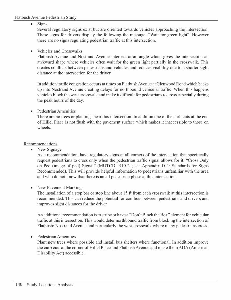
Signs• Several regulatory signs exist but are oriented towards vehicles approaching the intersection. These signs for drivers display the following the message: “Wait for green light”. However there are no signs regulating pedestrian traffic at this intersection.
Vehicles and Crosswalks• Flatbush Avenue and Nostrand Avenue intersect at an angle which gives the intersection an awkward shape where vehicles often wait for the green light partially in the crosswalk. This creates conflicts between pedestrians and vehicles and reduces visibility due to a shorter sight distance at the intersection for the driver.
In addition traffic congestion occurs at times on Flatbush Avenue at Glenwood Road which backs up into Nostrand Avenue creating delays for northbound vehicular traffic. When this happens vehicles block the west crosswalk and make it difficult for pedestrians to cross especially during the peak hours of the day.
Pedestrian Amenities• There are no trees or plantings near this intersection. In addition one of the curb cuts at the end of Hillel Place is not flush with the pavement surface which makes it inaccessible to those on wheels.
RecommendationsNew Signage • As a recommendation, have regulatory signs at all corners of the intersection that specifically request pedestrians to cross only when the pedestrian traffic signal allows for it: “Cross Only on Ped (image of ped) Signal” (MUTCD, R10-2a; see Appendix D-2: Standards for Signs Recommended). This will provide helpful information to pedestrians unfamiliar with the area and who do not know that there is an all pedestrian phase at this intersection.
New Pavement Markings • The installation of a stop bar or stop line about 15 ft from each crosswalk at this intersection is recommended. This can reduce the potential for conflicts between pedestrians and drivers and improves sight distances for the driver
An additional recommendation is to stripe or have a “Don’t Block the Box” element for vehicular traffic at this intersection. This would deter northbound traffic from blocking the intersection of Flatbush/ Nostrand Avenue and particularly the west crosswalk where many pedestrians cross.
Pedestrian Amenities • Plant new trees where possible and install bus shelters where functional. In addition improve the curb cuts at the corner of Hillel Place and Flatbush Avenue and make them ADA (American Disability Act) accessible.
140 Study Locations Analysis
Flatbush Avenue Pedestrian Study
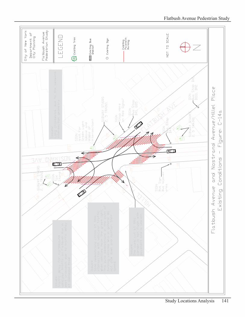
141Study Locations Analysis
Flatbush Avenue Pedestrian Study
142 Study Locations Analysis
Flatbush Avenue Pedestrian Study
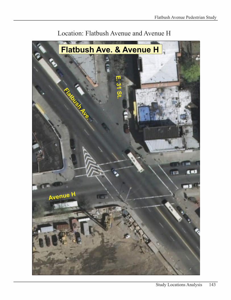
143Study Locations Analysis
Flatbush Avenue Pedestrian Study
Location: Flatbush Avenue and Avenue H
Flatbush Ave. & Avenue H
Flatbush Ave.
E. 31 St.
Avenue H
Intersection of Flatbush Avenue and Avenue HDescription of Existing ConditionsFlatbush Avenue is approximately 65 ft wide in this area. It has two travel lanes in each direction of traffic. The sidewalks are 14 to 17ft wide.
Avenue H is 40 ft wide. The sidewalks are 17 - 18 ft wide. This street is a two-way street with one travel lane in each direction of traffic.
Vehicle volumes at this intersection are moderate and can get heavy at times. Pedestrian volumes observed in this part of the study area are in general light, however the construction of a Target store will generate in the future additional pedestrian traffic at this intersection once completed and opened to the public.
The Target store is a three story retail project with 250,000 sq. ft. of retail space and an attached five story parking garage which contains 532 spaces. The 449,570 sq. ft of development project was under construction in 2007. It is now completed and opened to the public as of March 2008.
There is only one sign at this intersection related to pedestrian traffic. It is a “Stop” sign which requires drivers to come to a complete stop and to yield to pedestrians in the crosswalk. It is located at the northwest corner in the service/side road for southbound traffic making a right turn onto Avenue H.
Pedestrian Accident Data 2004 -20065 Pedestrian Accidents
Table: C-27 – Summary of Pedestrian Accidents
Accident Location Year Time Pedestrian ActionP e d e s t r i a n Location Vehicle Action
Avenue H 12/28/2004night, wet surface
crossing- no signal; no crosswalks at intersection
going straight ahead
Avenue H 12/13/2004 night, rain crossing with signal at intersection making a left turn
Avenue H 3/11/2005 dusk crossing with signal at intersection making a left turn
Avenue H 4/27/2005 daylight, wet crossing with signal at intersectionmaking a right turn
Avenue H 12/8/2006 not reported not reported at intersectionmaking a right turn
Problems and OpportunitiesPedestrian/ Vehicle Conflicts • Conflicts with vehicles making a turn at this intersection and pedestrians crossing with the green light often occur. Based on observation, most of the turning movements are made from Avenue H onto Flatbush Avenue.
Streetscape Improvemnet• There is a traffic island indicated with markings between Flatbush Avenue and the service/side road leading to Avenue H. Pedestrians waiting at the traffic island to cross Flatbush Avenue or
144 Study Locations Analysis
Flatbush Avenue Pedestrian Study
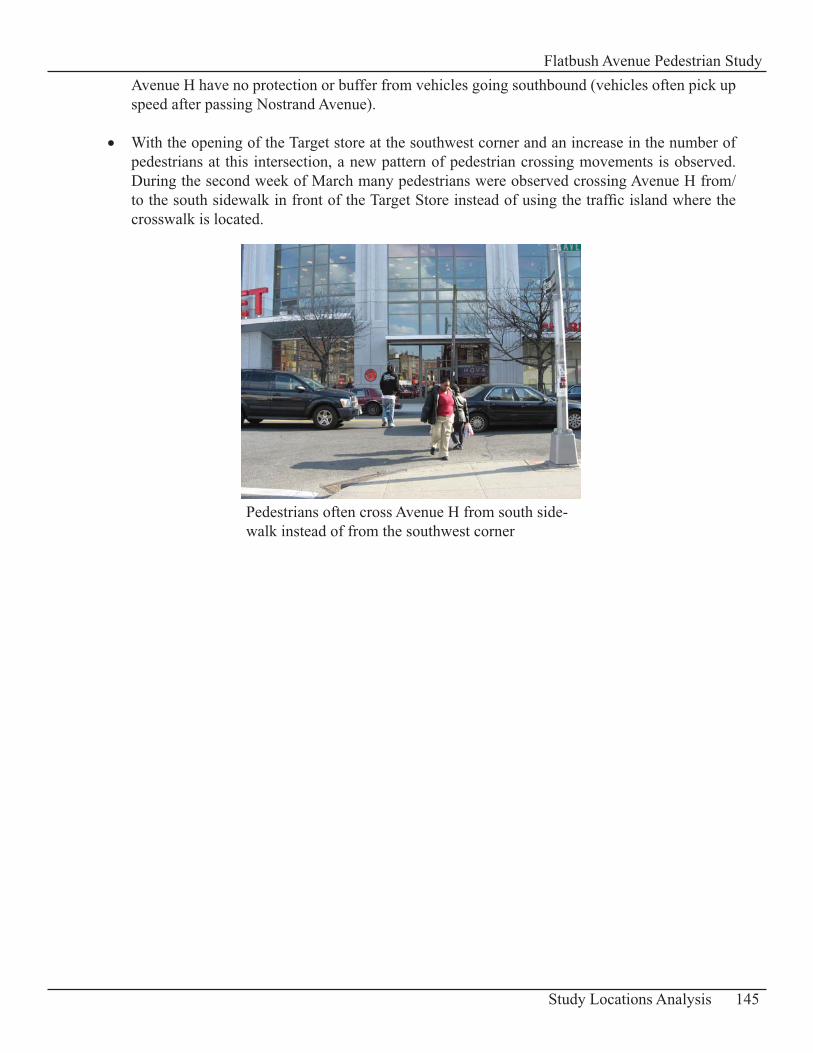
Avenue H have no protection or buffer from vehicles going southbound (vehicles often pick up speed after passing Nostrand Avenue).
With the opening of the Target store at the southwest corner and an increase in the number of • pedestrians at this intersection, a new pattern of pedestrian crossing movements is observed. During the second week of March many pedestrians were observed crossing Avenue H from/to the south sidewalk in front of the Target Store instead of using the traffic island where the crosswalk is located.
145Study Locations Analysis
Flatbush Avenue Pedestrian Study
Pedestrians often cross Avenue H from south side-walk instead of from the southwest corner
RecommendationsSignage• It is recommended to install the following warning sign “Attention Drivers Yield to Pedestrians” at all corners. This warning sign can help modify motorists’ turns and improve safety for pedestrians crossing at the intersection.
Streetscape Improvement• Build a raised concrete refuge island for pedestrians at the marked traffic island location. This can provide pedestrians with additional protection or buffer from vehicles traveling on Flatbush Avenue. In addition include greenstreets elements at the traffic island to improve the appearance of the intersection.
Add a New Crosswalk• Place another crosswalk approximately 60 feet west of the existing west crosswalk and parallel to it. This creates an additional designated crossing facility which is convenient and safe for pedestrians who choose to cross Avenue H at this location. A queuing space at the northwest street corner for pedestrians waiting for the signal to change is provided instead of the traffic island which is limited in terms of space for pedestrian queuing. An overloaded traffic island can affect vehicular traffic.
This new facility would evidently require at this intersection the installation of a new pedestrian signal and a “Stop Bar” for eastbound vehicular traffic.
146 Study Locations Analysis
Flatbush Avenue Pedestrian Study
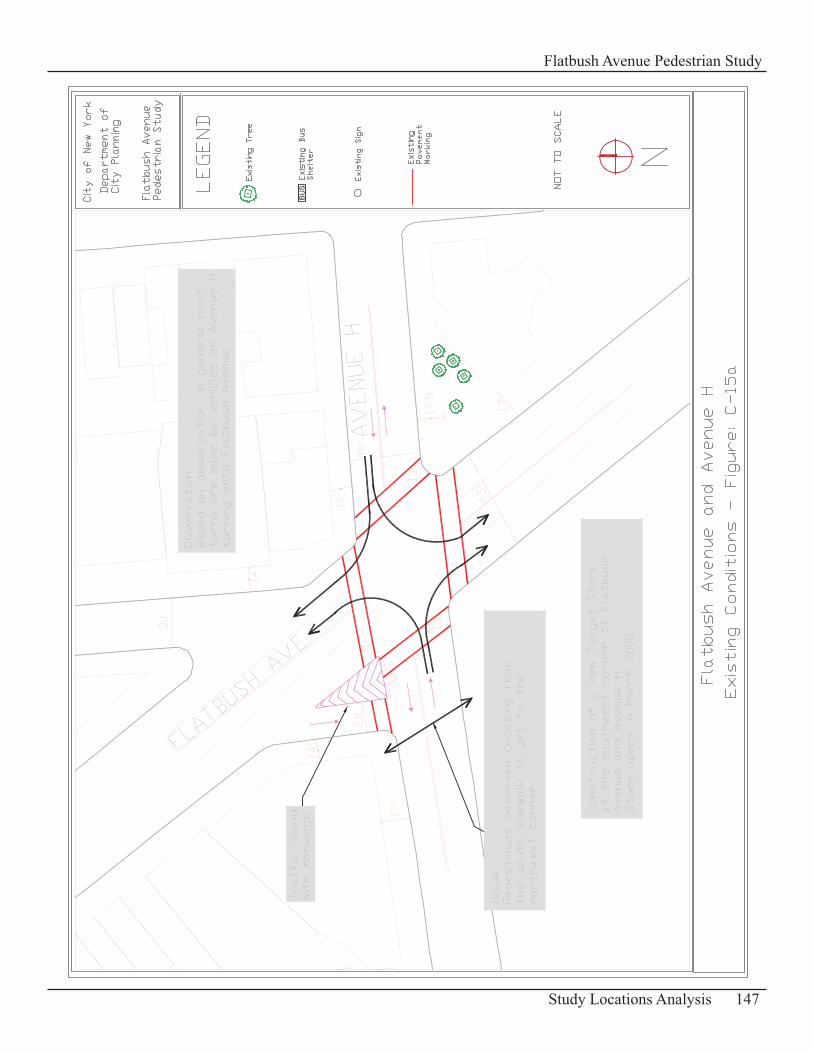
147Study Locations Analysis
Flatbush Avenue Pedestrian Study
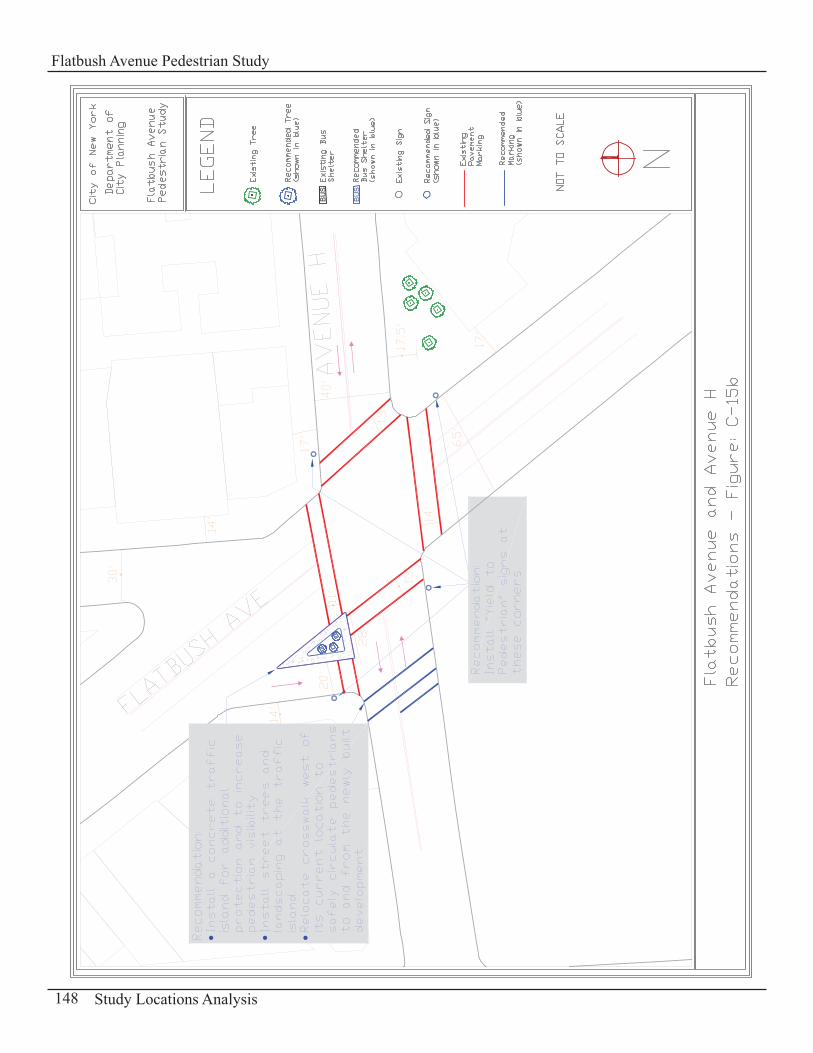
148 Study Locations Analysis
Flatbush Avenue Pedestrian Study
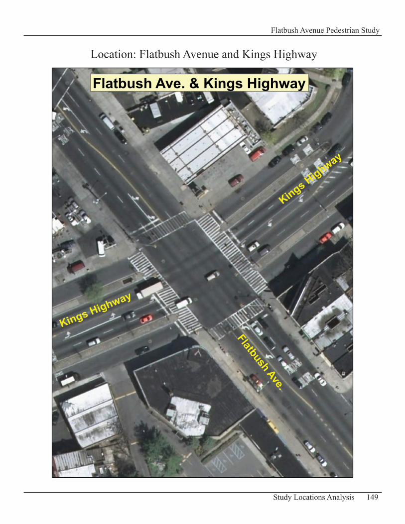
149Study Locations Analysis
Flatbush Avenue Pedestrian Study
Flatbush Ave. & Kings Highway
Flatbush Ave.
Kings Highway
Kings Highway
Location: Flatbush Avenue and Kings Highway
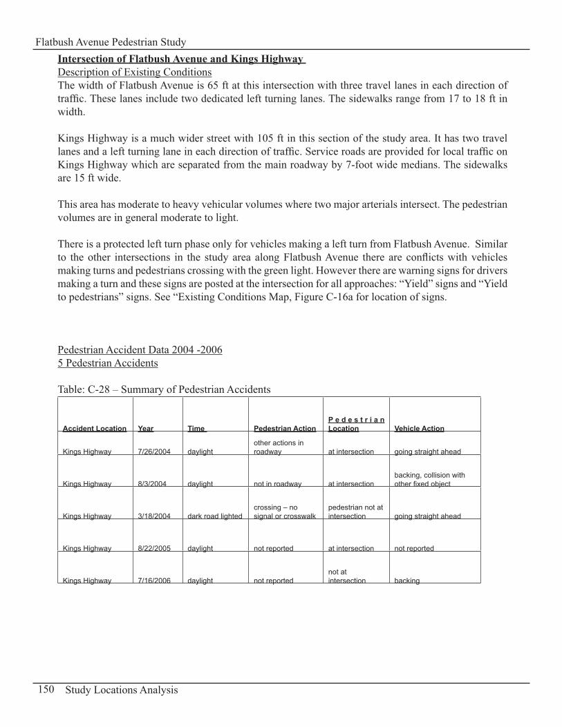
Intersection of Flatbush Avenue and Kings Highway Description of Existing ConditionsThe width of Flatbush Avenue is 65 ft at this intersection with three travel lanes in each direction of traffic. These lanes include two dedicated left turning lanes. The sidewalks range from 17 to 18 ft in width.
Kings Highway is a much wider street with 105 ft in this section of the study area. It has two travel lanes and a left turning lane in each direction of traffic. Service roads are provided for local traffic on Kings Highway which are separated from the main roadway by 7-foot wide medians. The sidewalks are 15 ft wide.
This area has moderate to heavy vehicular volumes where two major arterials intersect. The pedestrian volumes are in general moderate to light.
There is a protected left turn phase only for vehicles making a left turn from Flatbush Avenue. Similar to the other intersections in the study area along Flatbush Avenue there are conflicts with vehicles making turns and pedestrians crossing with the green light. However there are warning signs for drivers making a turn and these signs are posted at the intersection for all approaches: “Yield” signs and “Yield to pedestrians” signs. See “Existing Conditions Map, Figure C-16a for location of signs.
Pedestrian Accident Data 2004 -20065 Pedestrian Accidents
Table: C-28 – Summary of Pedestrian Accidents
Accident Location Year Time Pedestrian ActionP e d e s t r i a n Location Vehicle Action
Kings Highway 7/26/2004 daylightother actions in roadway at intersection going straight ahead
Kings Highway 8/3/2004 daylight not in roadway at intersectionbacking, collision with other fixed object
Kings Highway 3/18/2004 dark road lightedcrossing – no signal or crosswalk
pedestrian not at intersection going straight ahead
Kings Highway 8/22/2005 daylight not reported at intersection not reported
Kings Highway 7/16/2006 daylight not reportednot at intersection backing
150 Study Locations Analysis
Flatbush Avenue Pedestrian Study
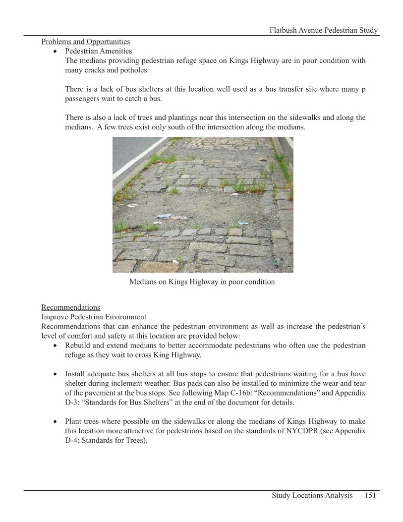
Problems and OpportunitiesPedestrian Amenities• The medians providing pedestrian refuge space on Kings Highway are in poor condition with many cracks and potholes.
There is a lack of bus shelters at this location well used as a bus transfer site where many p passengers wait to catch a bus.
There is also a lack of trees and plantings near this intersection on the sidewalks and along the medians. A few trees exist only south of the intersection along the medians.
RecommendationsImprove Pedestrian EnvironmentRecommendations that can enhance the pedestrian environment as well as increase the pedestrian’s level of comfort and safety at this location are provided below:
Rebuild and extend medians to better accommodate pedestrians who often use the pedestrian • refuge as they wait to cross King Highway.
Install adequate bus shelters at all bus stops to ensure that pedestrians waiting for a bus have • shelter during inclement weather. Bus pads can also be installed to minimize the wear and tear of the pavement at the bus stops. See following Map C-16b: “Recommendations” and Appendix D-3: “Standards for Bus Shelters” at the end of the document for details.
Plant trees where possible on the sidewalks or along the medians of Kings Highway to make • this location more attractive for pedestrians based on the standards of NYCDPR (see Appendix D-4: Standards for Trees).
151Study Locations Analysis
Flatbush Avenue Pedestrian Study
Medians on Kings Highway in poor condition
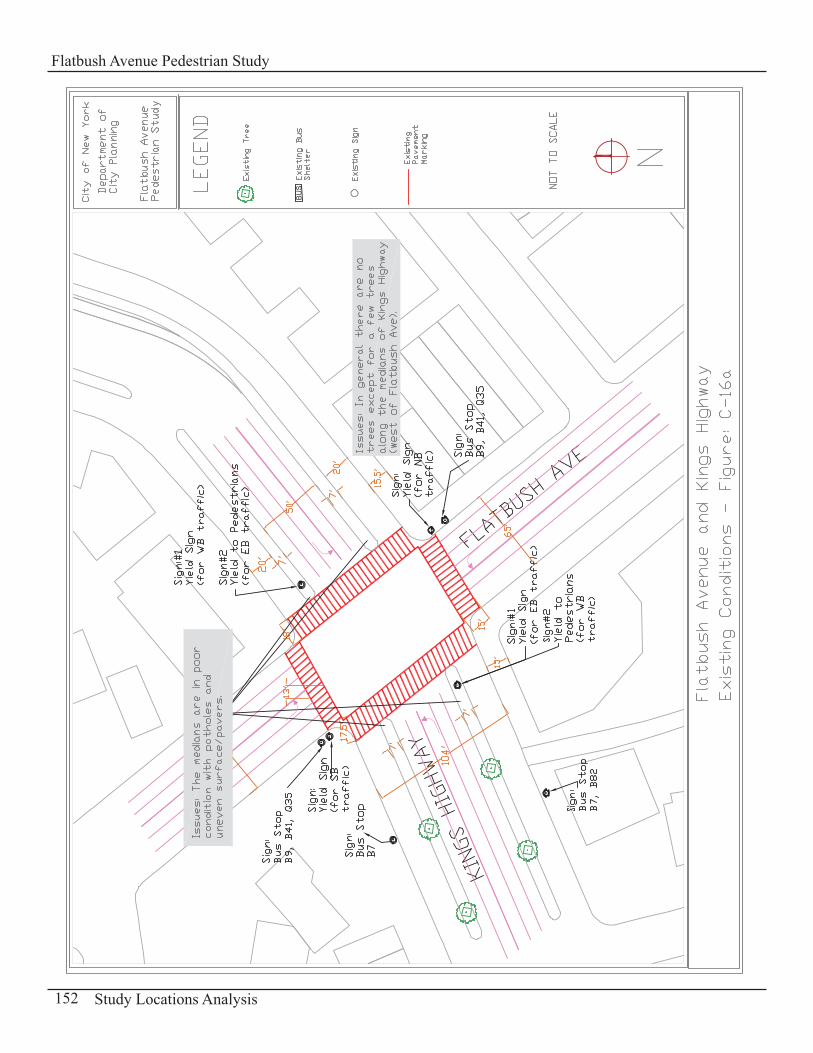
152 Study Locations Analysis
Flatbush Avenue Pedestrian Study
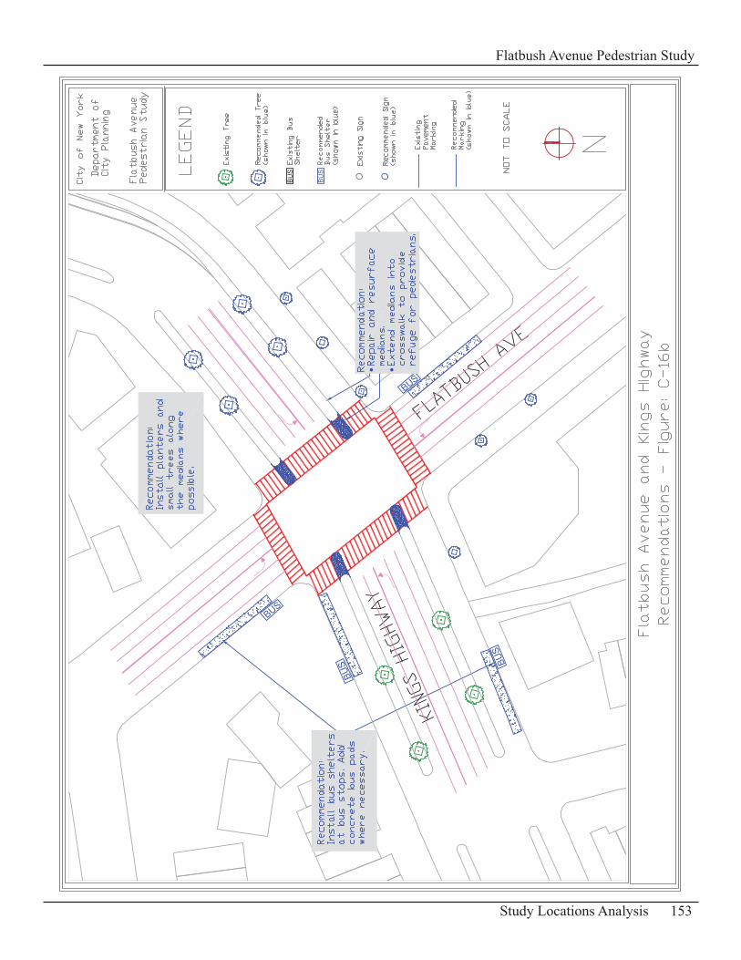
153Study Locations Analysis
Flatbush Avenue Pedestrian Study

154 Study Locations Analysis
Flatbush Avenue Pedestrian Study
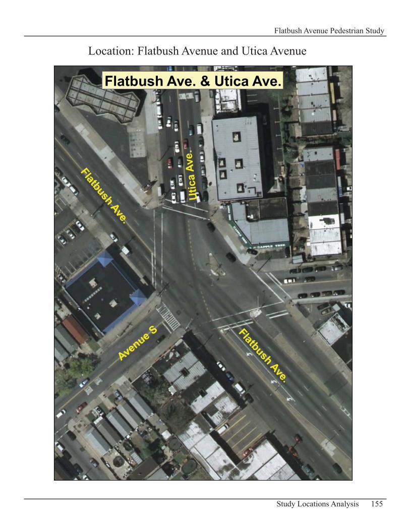
155Study Locations Analysis
Flatbush Avenue Pedestrian Study
Location: Flatbush Avenue and Utica Avenue
Flatbush Ave. & Utica Ave.
Flatbush Ave.
Avenue S
Utic
a Av
e.
Flatbush Ave.
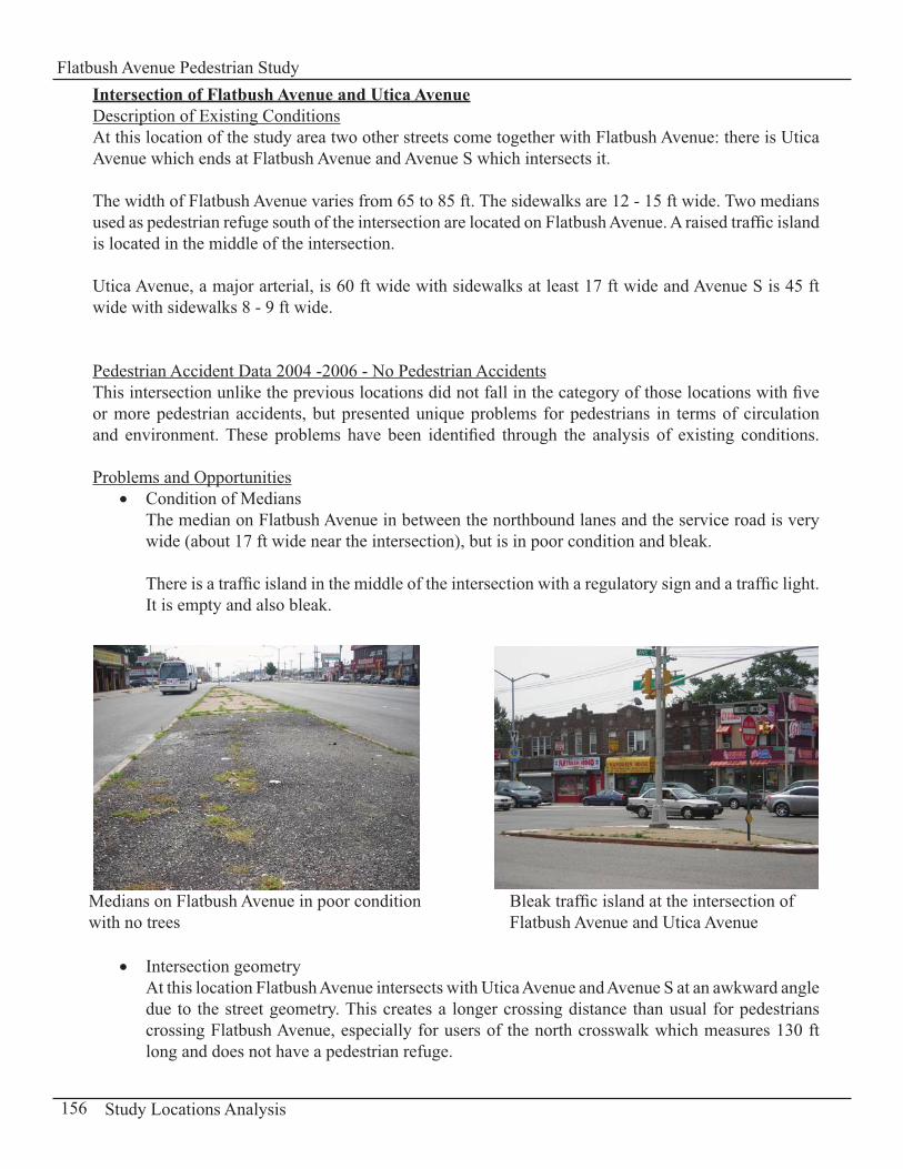
Intersection of Flatbush Avenue and Utica AvenueDescription of Existing ConditionsAt this location of the study area two other streets come together with Flatbush Avenue: there is Utica Avenue which ends at Flatbush Avenue and Avenue S which intersects it.
The width of Flatbush Avenue varies from 65 to 85 ft. The sidewalks are 12 - 15 ft wide. Two medians used as pedestrian refuge south of the intersection are located on Flatbush Avenue. A raised traffic island is located in the middle of the intersection.
Utica Avenue, a major arterial, is 60 ft wide with sidewalks at least 17 ft wide and Avenue S is 45 ft wide with sidewalks 8 - 9 ft wide.
Pedestrian Accident Data 2004 -2006 - No Pedestrian AccidentsThis intersection unlike the previous locations did not fall in the category of those locations with five or more pedestrian accidents, but presented unique problems for pedestrians in terms of circulation and environment. These problems have been identified through the analysis of existing conditions.
Problems and OpportunitiesCondition of Medians• The median on Flatbush Avenue in between the northbound lanes and the service road is very wide (about 17 ft wide near the intersection), but is in poor condition and bleak.
There is a traffic island in the middle of the intersection with a regulatory sign and a traffic light. It is empty and also bleak.
Intersection geometry• At this location Flatbush Avenue intersects with Utica Avenue and Avenue S at an awkward angle due to the street geometry. This creates a longer crossing distance than usual for pedestrians crossing Flatbush Avenue, especially for users of the north crosswalk which measures 130 ft long and does not have a pedestrian refuge.
156 Study Locations Analysis
Flatbush Avenue Pedestrian Study
Bleak traffic island at the intersection of Flatbush Avenue and Utica Avenue
Medians on Flatbush Avenue in poor conditionwith no trees
Condition of curb cuts• The curb cuts at this intersection are in good condition except for the curb cuts located at the southwest corner and the northeast corner of Avenue S and Flatbush Avenue.
Pedestrian Amenities• There are no trees or planters along the medians or on the sidewalks in this part of the study area.
RecommendationsImprove Condition of Medians• The median with a width of 17 ft should be repaired and resurfaced. Trees and landscaping can be added to make this location more attractive and inviting to pedestrians. The traffic island in the middle of the intersection could also be enhanced with “greenstreets” elements.
Install Curb Extensions• Extend the curb at the northwest corner (bulb-outs). This can improve pedestrians crossing by reducing the distance for pedestrians crossing Flatbush Avenue at the north crosswalk.
The length of the corner extension should be done in a way that it does not impede on the right turns from Utica Avenue.
Pedestrian Amenities• Install bus shelters at three bus stops (one on Flatbush Avenue and two on Avenue S) to ensure that all pedestrians waiting for a bus at this location have a convenient place to wait. Concrete bus pads can also be added to minimize the wear and tear of the pavement at the bus stops.
Trees and planters can be planted or placed on the sidewalks where possible (except at the gas station) to make this area more attractive for pedestrians.
Finally reconstruct a few of the curb cuts at the northeast and southwest corners of the intersection of Avenue S and Flatbush Avenue. (See following Map C-17b: “Recommendations” for details on pedestrian amenities).
157Study Locations Analysis
Flatbush Avenue Pedestrian Study
158 Study Locations Analysis
Flatbush Avenue Pedestrian Study
159Study Locations Analysis
Flatbush Avenue Pedestrian Study

160 Study Locations Analysis
Flatbush Avenue Pedestrian Study
161Study Locations Analysis
Flatbush Avenue Pedestrian Study
Other Study Locations
- E 26th Street (SB traffic – west of Flatbush Ave.)- E 26th Street (NB traffic – east of Flatbush Ave.)- E 31st Street (NB traffic – east of Flatbush Ave.)- Aurelia Court (WB traffic – east of Flatbush Ave.) - E 34th Street – (SB traffic - west of Flatbush Ave)- Brooklyn Ave (NB traffic – east of Flatbush Ave.)- E 36th Street (SB traffic – west of Flatbush Ave.)- E 38th Street (SB traffic - west of Flatbush Ave.)- Hubbard Place (EB traffic - east of Flatbush Ave.)- Alton Place (EB traffic - east of Flatbush Ave.)- Lott Place (EB traffic- east of Flatbush Ave.)- Baughman Pl (EB traffic - east of Flatbush Ave)- Schenectady Avenue (NB traffic – east of Flatbush Ave.)- E 48th Street (NB traffic – east of Flatbush Ave.)- E 51st Street (NB traffic – east of Flatbush Ave.)- E 53rd Street (NB traffic, east of Flatbush Ave.)

162 Study Locations Analysis
Flatbush Avenue Pedestrian Study
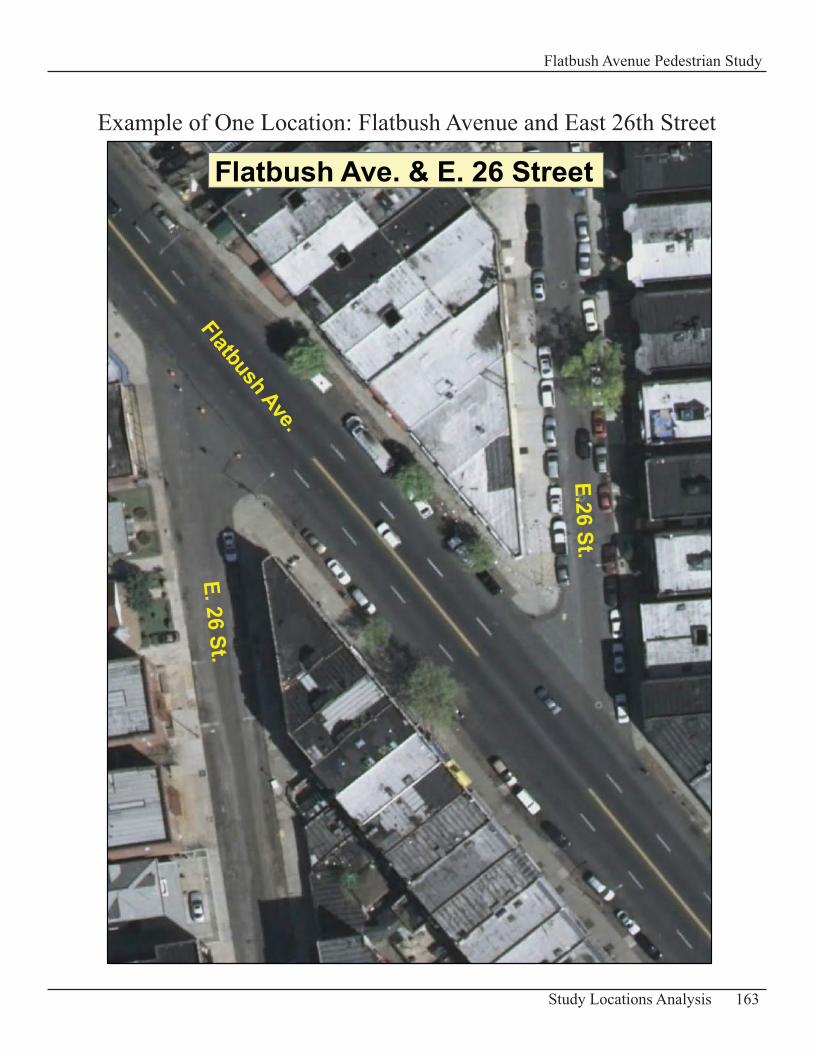
163Study Locations Analysis
Flatbush Avenue Pedestrian Study
Flatbush Ave. & E. 26 Street
Flatbush Ave.
E.26 St.
E. 26 St.
Example of One Location: Flatbush Avenue and East 26th Street
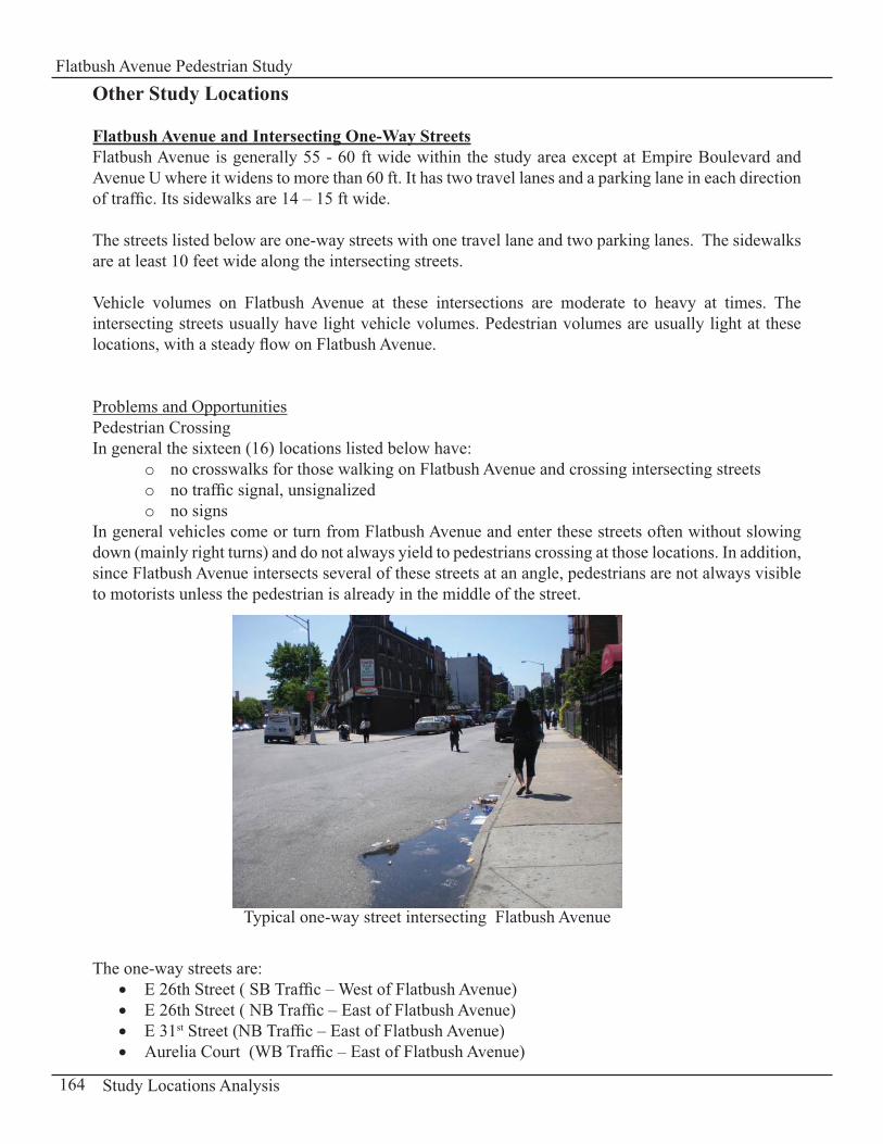
Other Study Locations
Flatbush Avenue and Intersecting One-Way StreetsFlatbush Avenue is generally 55 - 60 ft wide within the study area except at Empire Boulevard and Avenue U where it widens to more than 60 ft. It has two travel lanes and a parking lane in each direction of traffic. Its sidewalks are 14 – 15 ft wide.
The streets listed below are one-way streets with one travel lane and two parking lanes. The sidewalks are at least 10 feet wide along the intersecting streets.
Vehicle volumes on Flatbush Avenue at these intersections are moderate to heavy at times. The intersecting streets usually have light vehicle volumes. Pedestrian volumes are usually light at these locations, with a steady flow on Flatbush Avenue.
Problems and OpportunitiesPedestrian Crossing In general the sixteen (16) locations listed below have:
no crosswalks for those walking on Flatbush Avenue and crossing intersecting streetso no traffic signal, unsignalizedo no signso
In general vehicles come or turn from Flatbush Avenue and enter these streets often without slowing down (mainly right turns) and do not always yield to pedestrians crossing at those locations. In addition, since Flatbush Avenue intersects several of these streets at an angle, pedestrians are not always visible to motorists unless the pedestrian is already in the middle of the street.
The one-way streets are:E 26th Street ( SB Traffic – West of Flatbush Avenue)• E 26th Street ( NB Traffic – East of Flatbush Avenue)• E 31• st Street (NB Traffic – East of Flatbush Avenue)Aurelia Court (WB Traffic – East of Flatbush Avenue) •
164 Study Locations Analysis
Flatbush Avenue Pedestrian Study
Typical one-way street intersecting Flatbush Avenue
E 34• th Street – (SB traffic - West of Flatbush Avenue)Brooklyn Avenue (NB Traffic – East of Flatbush Avenue)• E 36• th Street (SB traffic – West of Flatbush Avenue) E 38• th Street (SB traffic - West of Flatbush Avenue)Hubbard Place (EB Traffic - East of Flatbush Avenue)• Alton Place (EB Traffic - East of Flatbush Avenue)• Lott Place (EB Traffic- East of Flatbush Avenue)• Baughman Place (EB Traffic - east of Flatbush Avenue)• Schenectady Avenue (NB Traffic – East of Flatbush Avenue)• E 48• th Street (NB Traffic – East of Flatbush Avenue)E 51• st Street (NB Traffic – East of Flatbush Avenue)E 53• rd Street (Traffic island at approach – East of Flatbush Avenue)
RecommendationsImprove Pedestrian Crossing • To improve pedestrians’ safety at these intersections it is recommended to redesign the corners by extending the curb line out 6 ft at each corner in order to slow down motorists making turns from Flatbush Avenue and to reduce pedestrians’ crossing distance.
This solution improves the ability for motorists to see pedestrians stepping off the curb as they approach the intersection especially when the one-way street intersects Flatbush Avenue at an angle. It shortens pedestrian crossing distance therefore reducing pedestrian’s exposure time in the street to vehicles. Finally, it prevents vehicles from being parked too close to the corner which often blocks motorists’ sightlines and visibility of pedestrians and other vehicles.
This can also be accomplished with pavement markings that fill in the space on the pavement proposed for the curb extension.
In addition “Yield” signs can be added if necessary to reinforce the action to have vehicles slow down as they make a turn into the one-way street.
165Study Locations Analysis
Flatbush Avenue Pedestrian Study
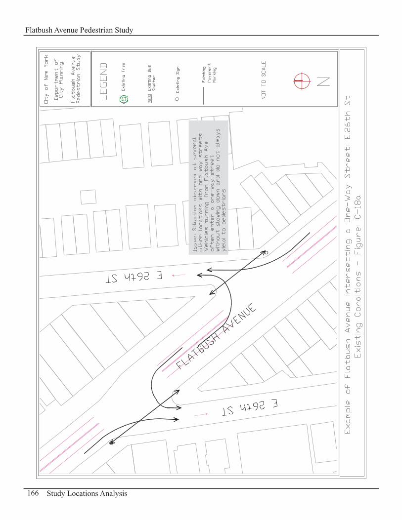
166 Study Locations Analysis
Flatbush Avenue Pedestrian Study
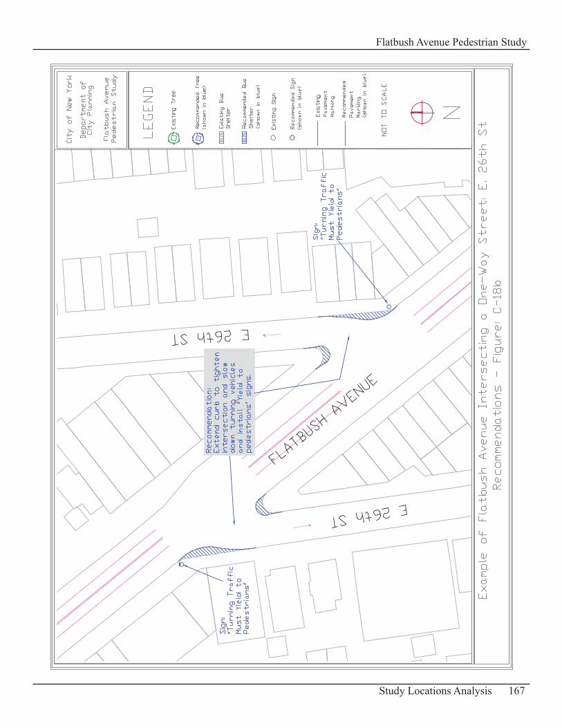
167Study Locations Analysis
Flatbush Avenue Pedestrian Study
Conclusion
This report is an assessment of existing conditions along Flatbush Avenue within the study area and presents the issues, problems and opportunities in relation to pedestrians’ safety and mobility. General problems observed along this major arterial include pedestrian-vehicular conflicts at intersections, illegal midblock crossings by pedestrians, blocking of crosswalk, lack of signage, lack of pedestrian amenities.Recommended improvements such as additional signage, specific street treatments, operational changes (LPI phase, new crosswalk) have been developed to address them.
The next steps are to further assess the feasibility of proposed recommendations that require signal timing adjustments, restricted turns, new crosswalks, new bus shelters, relocation of a bus stop, planting of trees/planters, increased enforcement presence and to work in cooperation with New York City Department of Transportation, New York City Department of Parks and Recreation, the Metropolitan Transportation Authority and the New York City Police Department. This will require field tests and an evaluation of the effectiveness of proposed improvements.
Pedestrian improvements along Flatbush Avenue will make walking safer and more pleasant, encouraging greater pedestrian use and strengthening the economic vitality of this major arterial.

REFERENCES
1 NYC Landmarks Preservation Commission, [Available at: http://ww.nyc.gov/html/lpc/downloads/pdf/reports/ehall.pdf]
2 Available at: http://ww.brooklyn.cuny.edu/pub/bc_history.htm
3 Available at: http://www.brooklynonline.com/history/oldhomes.html)

170 Appendices
Flatbush Avenue Pedestrian Study
171Appendices
Flatbush Avenue Pedestrian Study
Part D
Appendices
Appendix D-1: Level of Service Methodology and Traffic Volumes
Appendix D-2: Standards for Signs Recommended
Appendix D-3: Standards for Bus Shelters
Appendix D-4: Tree Planting Guidelines
Appendix D-5: Literature Search
172 Appendices
Flatbush Avenue Pedestrian Study
Appendix D-1:
Level of Service Methodology
and
Vehicular and Pedestrian Traffic Volumes- Flatbush Avenue and Church Avenue- Flatbush Avenue and Foster/Bedford Avenues- Flatbush Avenue and Avenue U
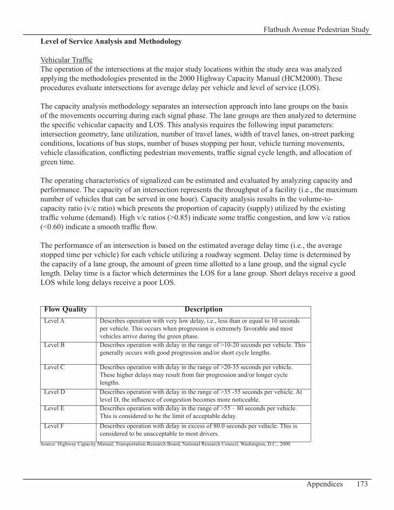
Level of Service Analysis and Methodology
Vehicular TrafficThe operation of the intersections at the major study locations within the study area was analyzed applying the methodologies presented in the 2000 Highway Capacity Manual (HCM2000). These procedures evaluate intersections for average delay per vehicle and level of service (LOS).
The capacity analysis methodology separates an intersection approach into lane groups on the basis of the movements occurring during each signal phase. The lane groups are then analyzed to determine the specific vehicular capacity and LOS. This analysis requires the following input parameters: intersection geometry, lane utilization, number of travel lanes, width of travel lanes, on-street parking conditions, locations of bus stops, number of buses stopping per hour, vehicle turning movements, vehicle classification, conflicting pedestrian movements, traffic signal cycle length, and allocation of green time.
The operating characteristics of signalized can be estimated and evaluated by analyzing capacity and performance. The capacity of an intersection represents the throughput of a facility (i.e., the maximum number of vehicles that can be served in one hour). Capacity analysis results in the volume-to-capacity ratio (v/c ratio) which presents the proportion of capacity (supply) utilized by the existing traffic volume (demand). High v/c ratios (>0.85) indicate some traffic congestion, and low v/c ratios (<0.60) indicate a smooth traffic flow.
The performance of an intersection is based on the estimated average delay time (i.e., the average stopped time per vehicle) for each vehicle utilizing a roadway segment. Delay time is determined by the capacity of a lane group, the amount of green time allotted to a lane group, and the signal cycle length. Delay time is a factor which determines the LOS for a lane group. Short delays receive a good LOS while long delays receive a poor LOS.
Flow Quality DescriptionLevel A Describes operation with very low delay, i.e., less than or equal to 10 seconds
per vehicle. This occurs when progression is extremely favorable and most vehicles arrive during the green phase.
Level B Describes operation with delay in the range of >10-20 seconds per vehicle. This generally occurs with good progression and/or short cycle lengths.
Level C Describes operation with delay in the range of >20-35 seconds per vehicle. These higher delays may result from fair progression and/or longer cycle lengths.
Level D Describes operation with delay in the range of >35 -55 seconds per vehicle. At level D, the influence of congestion becomes more noticeable.
Level E Describes operation with delay in the range of >55 – 80 seconds per vehicle. This is considered to be the limit of acceptable delay.
Level F Describes operation with delay in excess of 80.0 seconds per vehicle. This is considered to be unacceptable to most drivers.
Source: Highway Capacity Manual, Transportation Research Board, National Research Council, Washington, D.C., 2000.
173Appendices
Flatbush Avenue Pedestrian Study
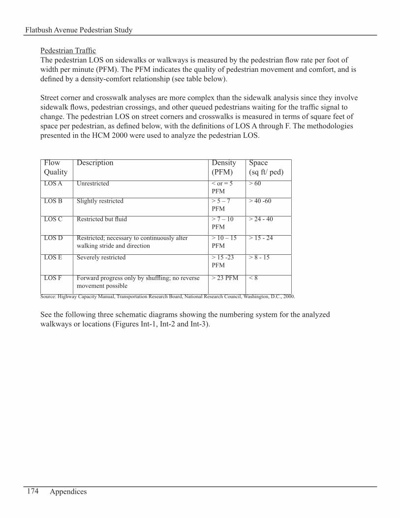
Pedestrian TrafficThe pedestrian LOS on sidewalks or walkways is measured by the pedestrian flow rate per foot of width per minute (PFM). The PFM indicates the quality of pedestrian movement and comfort, and is defined by a density-comfort relationship (see table below).
Street corner and crosswalk analyses are more complex than the sidewalk analysis since they involve sidewalk flows, pedestrian crossings, and other queued pedestrians waiting for the traffic signal to change. The pedestrian LOS on street corners and crosswalks is measured in terms of square feet of space per pedestrian, as defined below, with the definitions of LOS A through F. The methodologies presented in the HCM 2000 were used to analyze the pedestrian LOS.
Flow Quality
Description Density (PFM)
Space (sq ft/ ped)
LOS A Unrestricted < or = 5 PFM
> 60
LOS B Slightly restricted > 5 – 7 PFM
> 40 -60
LOS C Restricted but fluid > 7 – 10 PFM
> 24 - 40
LOS D Restricted; necessary to continuously alter walking stride and direction
> 10 – 15 PFM
> 15 - 24
LOS E Severely restricted > 15 -23 PFM
> 8 - 15
LOS F Forward progress only by shuffling; no reverse movement possible
> 23 PFM < 8
Source: Highway Capacity Manual, Transportation Research Board, National Research Council, Washington, D.C., 2000.
See the following three schematic diagrams showing the numbering system for the analyzed walkways or locations (Figures Int-1, Int-2 and Int-3).
174 Appendices
Flatbush Avenue Pedestrian Study
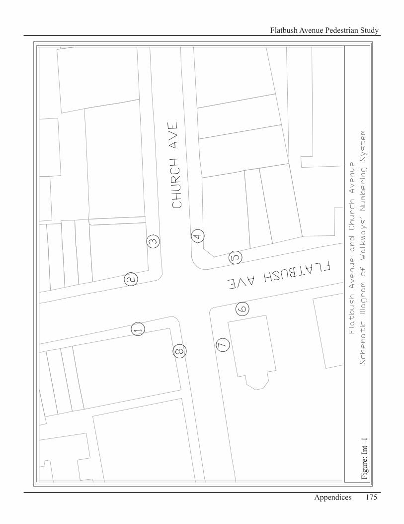
175Appendices
Flatbush Avenue Pedestrian Study
Figu
re: I
nt -1
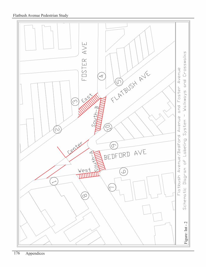
176 Appendices
Flatbush Avenue Pedestrian Study
Figu
re: I
nt -
2
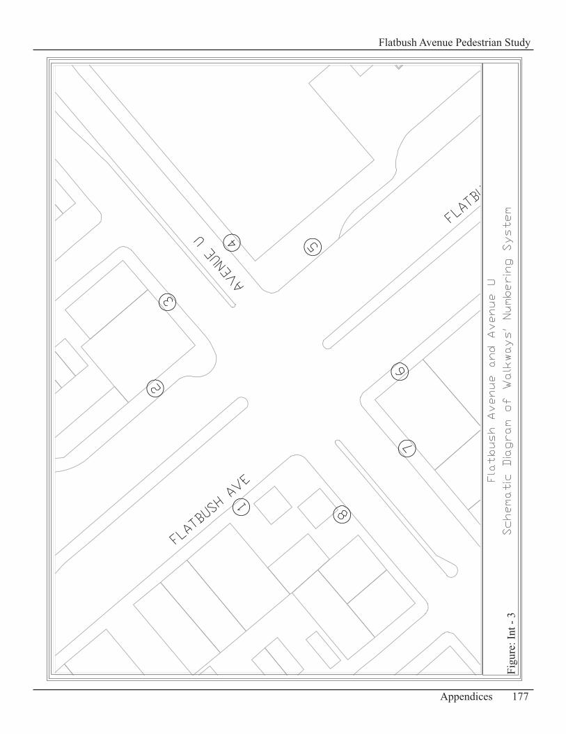
177Appendices
Flatbush Avenue Pedestrian Study
Figu
re: I
nt -
3
Vehicular and Pedestrian Traffic Volumes CollectedVehicular and pedestrian traffic volumes for the LOS analysis were collected during the peak hours of the weekday: 7:00 – 9:00 AM12:00 – 2:00 PM4:00 – 6:00 PMand on a Saturday during the midday peak hours from 1:00 – 3:00 PM.
See following intersection maps (Figures 1-24) in Appendix D-1 for detailed traffic and pedestrian volumes.
178 Appendices
Flatbush Avenue Pedestrian Study
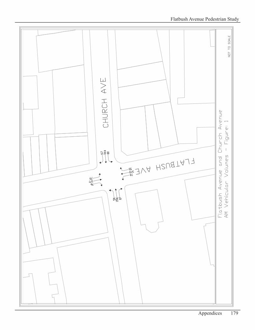
179Appendices
Flatbush Avenue Pedestrian Study

180 Appendices
Flatbush Avenue Pedestrian Study
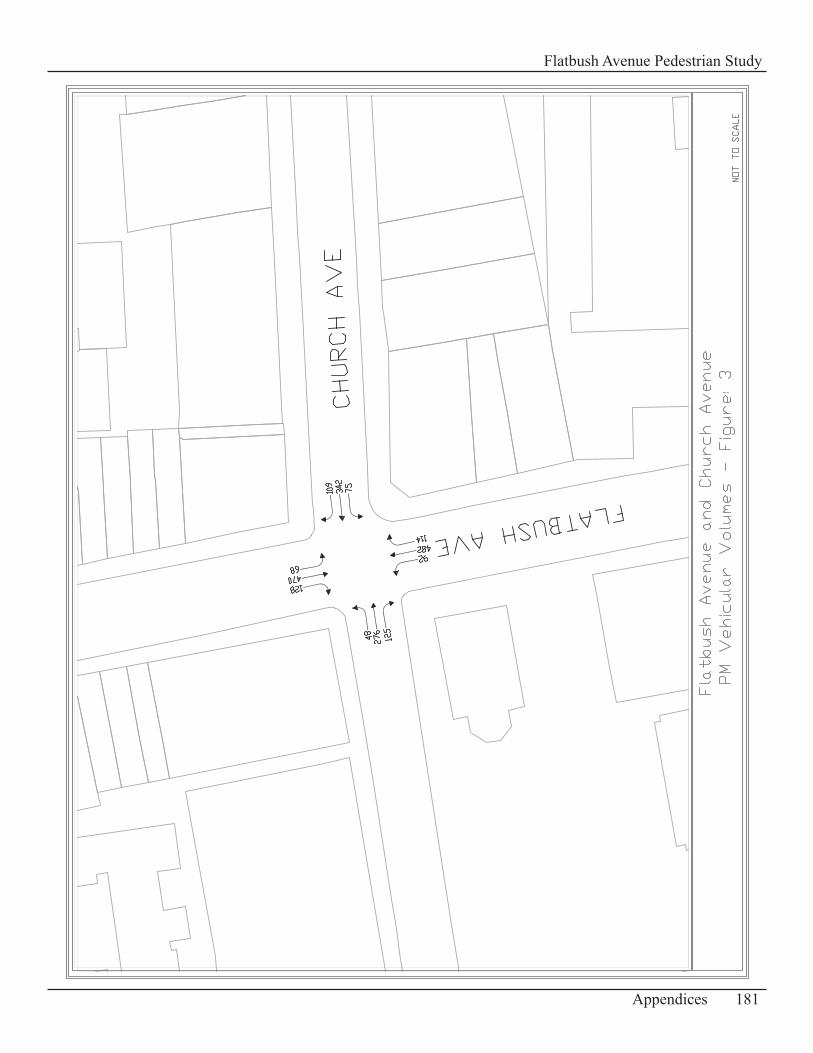
181Appendices
Flatbush Avenue Pedestrian Study
182 Appendices
Flatbush Avenue Pedestrian Study
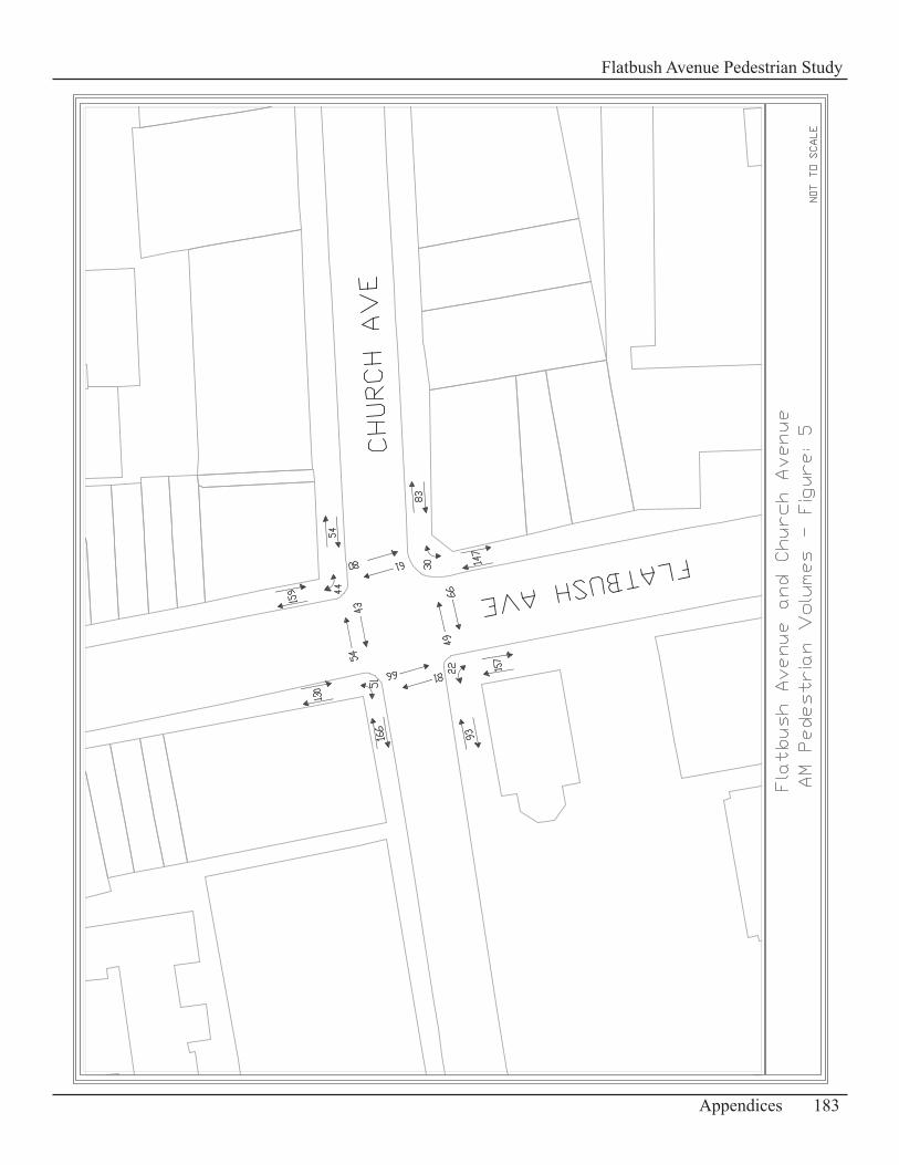
183Appendices
Flatbush Avenue Pedestrian Study
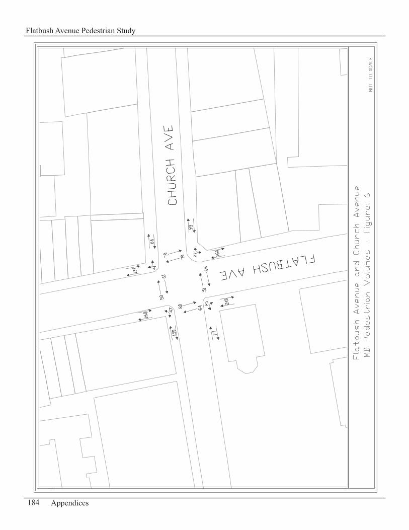
184 Appendices
Flatbush Avenue Pedestrian Study
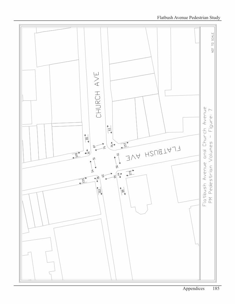
185Appendices
Flatbush Avenue Pedestrian Study
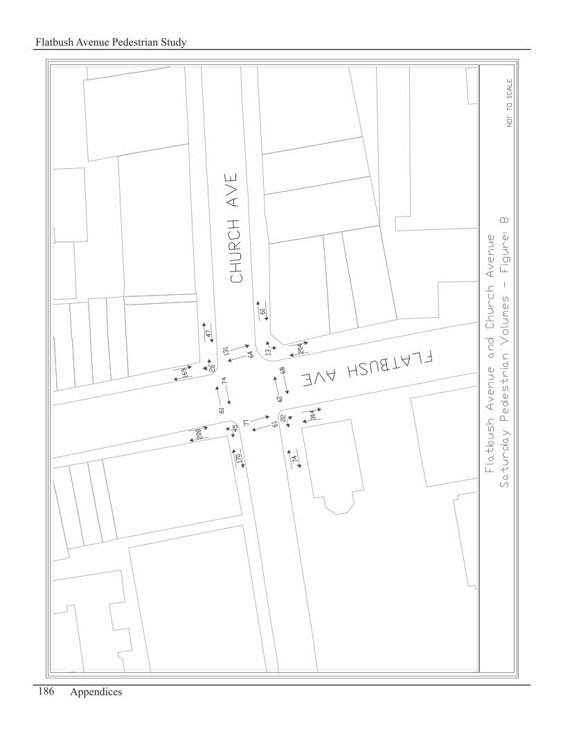
186 Appendices
Flatbush Avenue Pedestrian Study
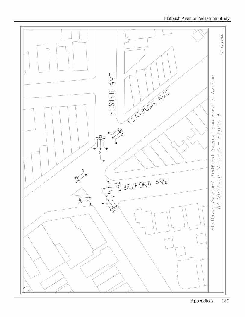
187Appendices
Flatbush Avenue Pedestrian Study
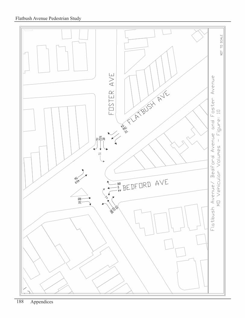
188 Appendices
Flatbush Avenue Pedestrian Study
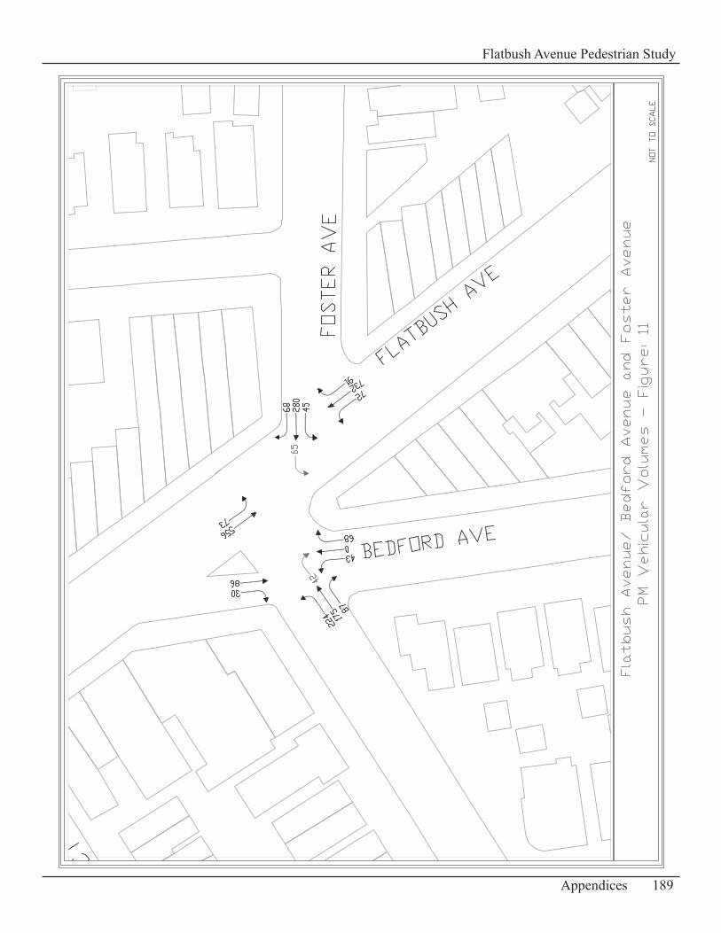
189Appendices
Flatbush Avenue Pedestrian Study
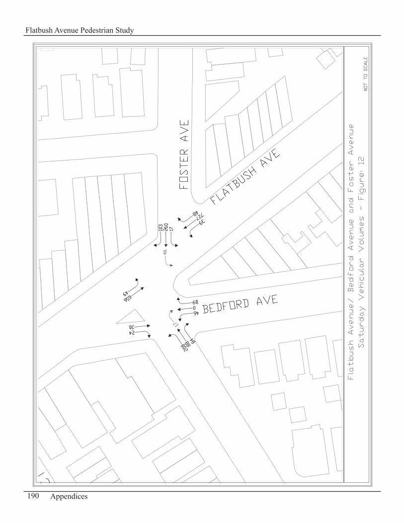
190 Appendices
Flatbush Avenue Pedestrian Study
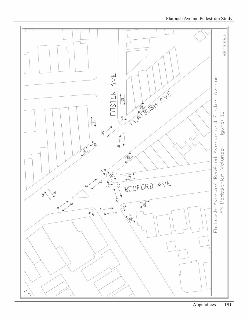
191Appendices
Flatbush Avenue Pedestrian Study
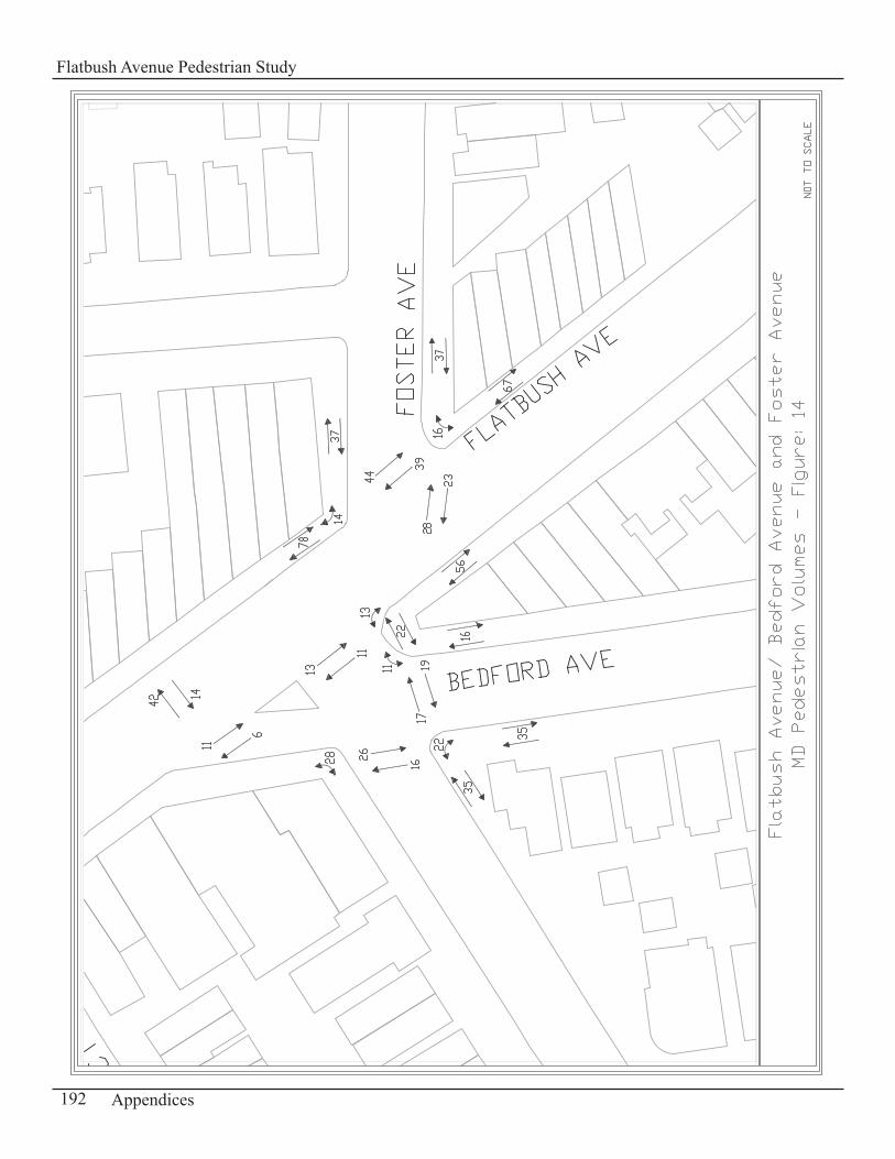
192 Appendices
Flatbush Avenue Pedestrian Study
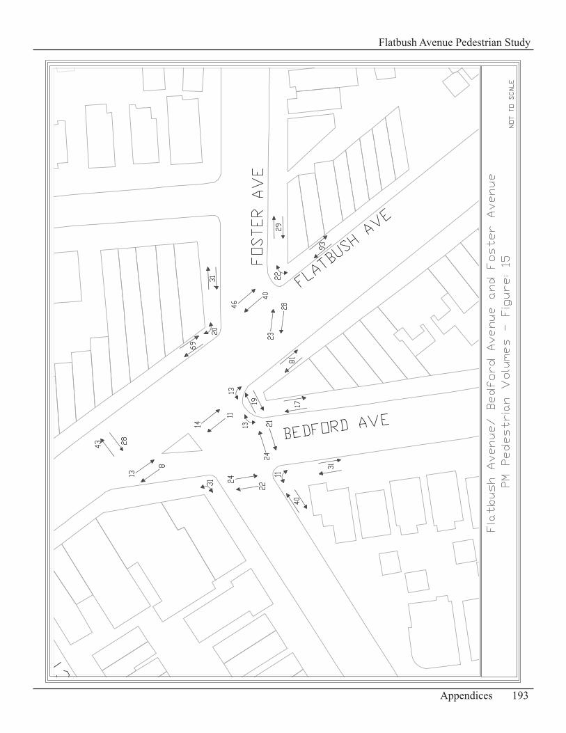
193Appendices
Flatbush Avenue Pedestrian Study
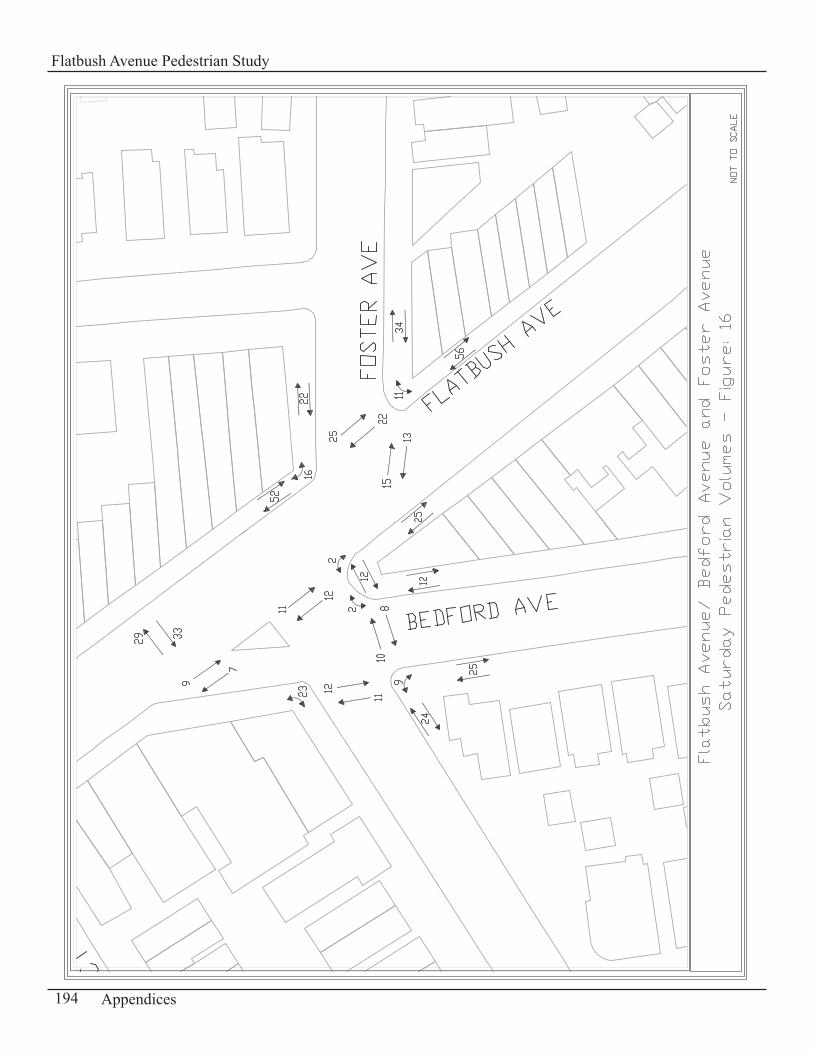
194 Appendices
Flatbush Avenue Pedestrian Study
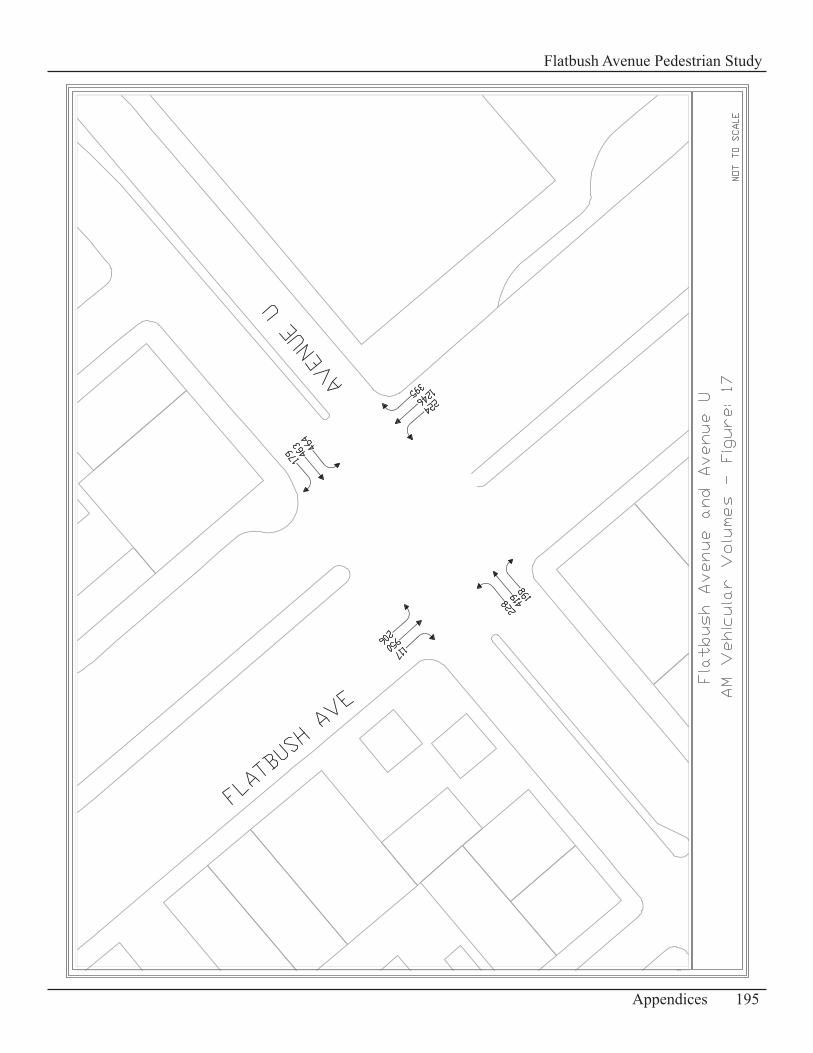
195Appendices
Flatbush Avenue Pedestrian Study
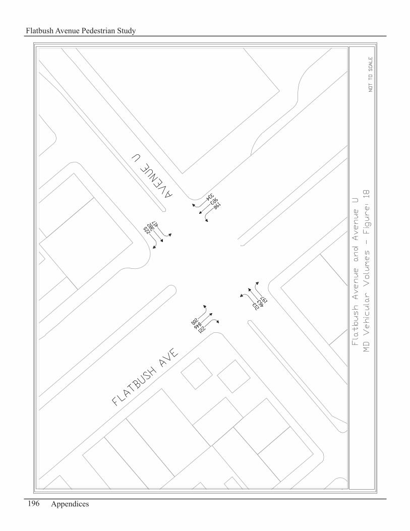
196 Appendices
Flatbush Avenue Pedestrian Study
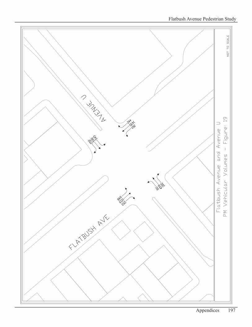
197Appendices
Flatbush Avenue Pedestrian Study
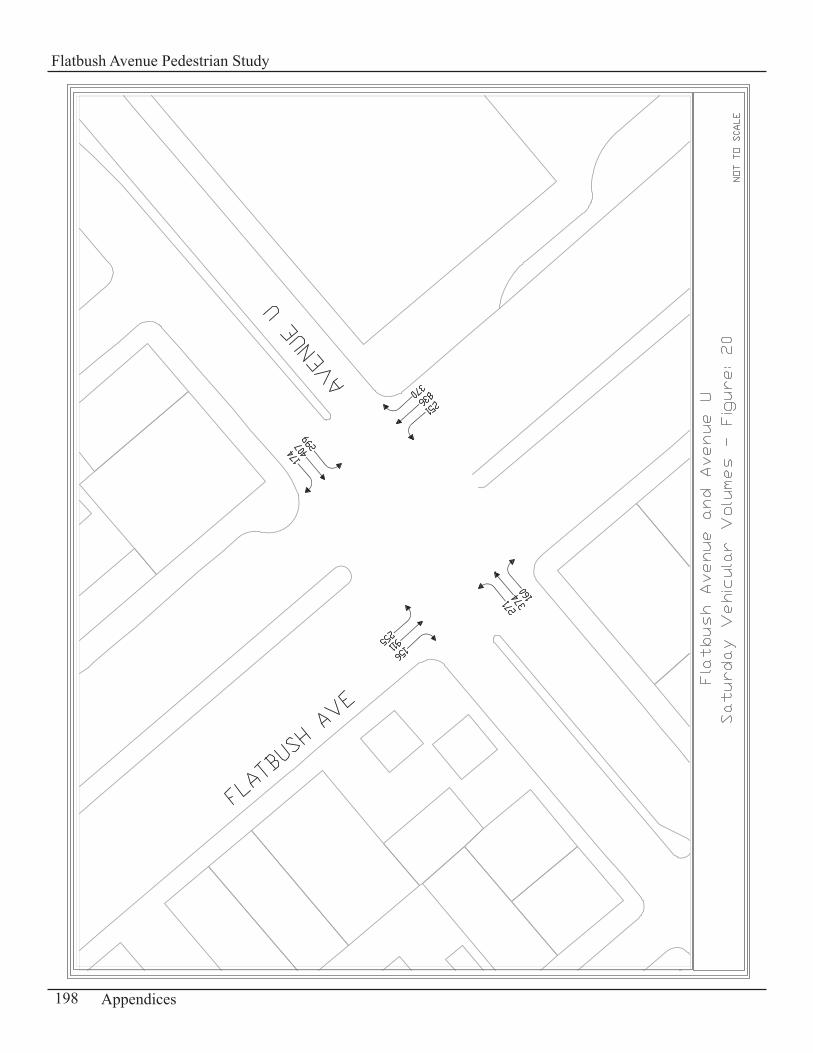
198 Appendices
Flatbush Avenue Pedestrian Study
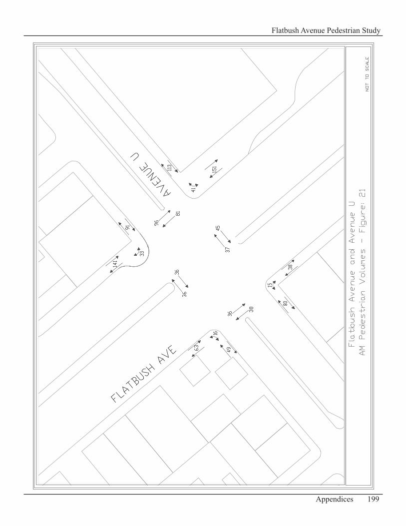
199Appendices
Flatbush Avenue Pedestrian Study
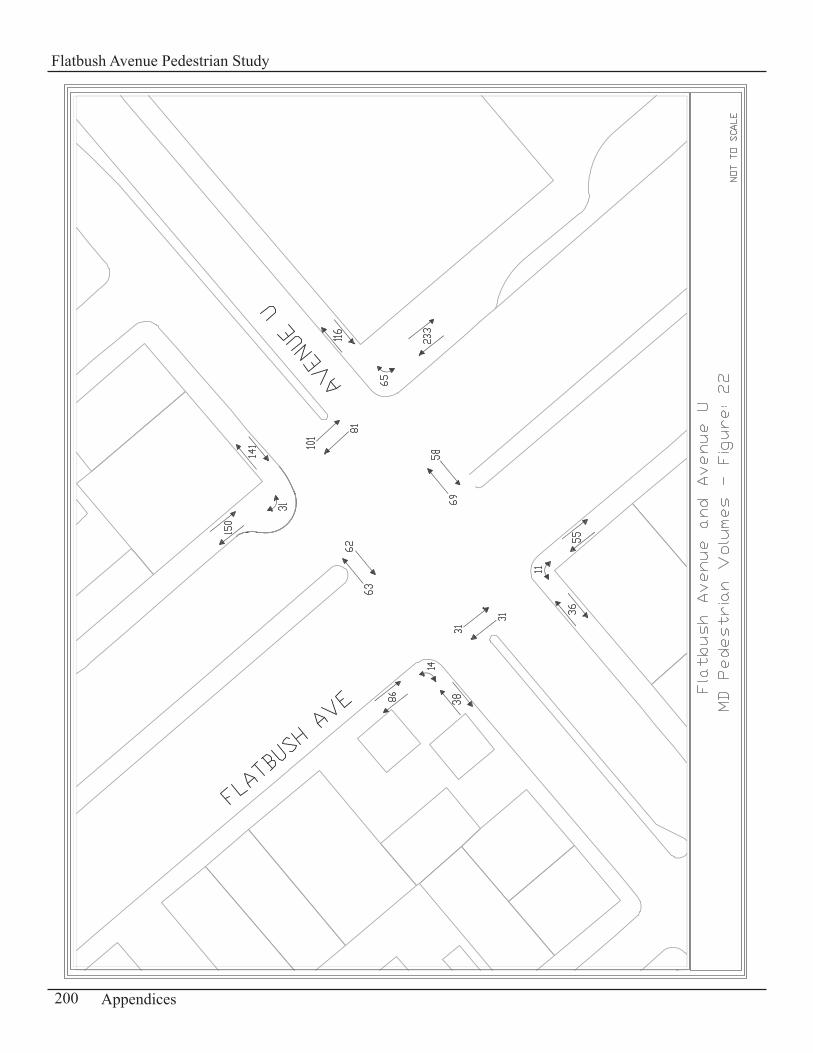
200 Appendices
Flatbush Avenue Pedestrian Study
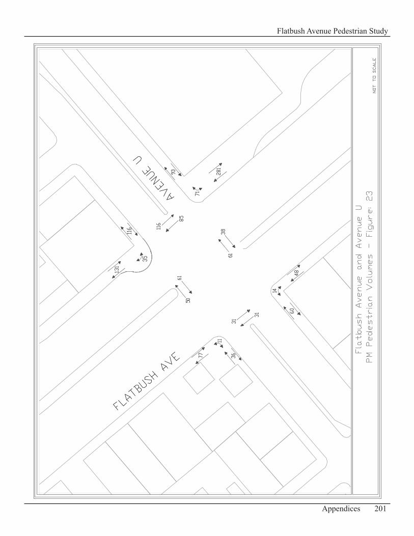
201Appendices
Flatbush Avenue Pedestrian Study

202 Appendices
Flatbush Avenue Pedestrian Study

203Appendices
Flatbush Avenue Pedestrian Study
204 Appendices
Flatbush Avenue Pedestrian Study
Appendix D-2:Standards for Signs Recommended
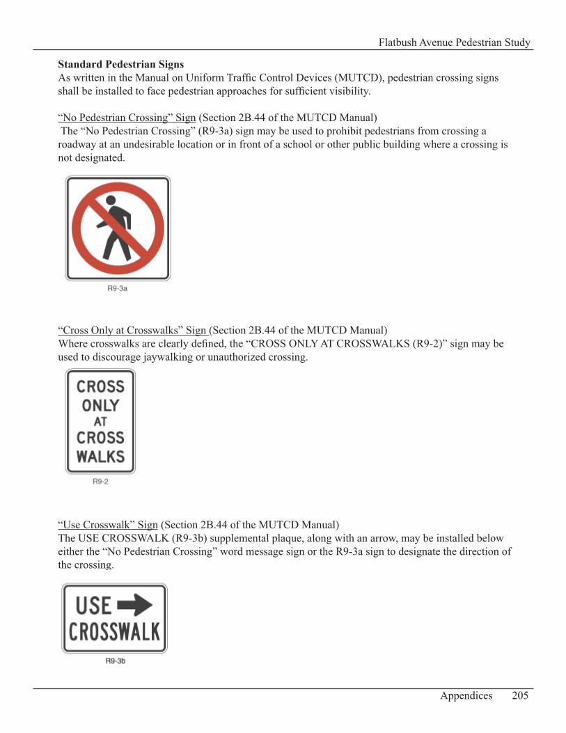
Standard Pedestrian Signs As written in the Manual on Uniform Traffic Control Devices (MUTCD), pedestrian crossing signs shall be installed to face pedestrian approaches for sufficient visibility.
“No Pedestrian Crossing” Sign (Section 2B.44 of the MUTCD Manual) The “No Pedestrian Crossing” (R9-3a) sign may be used to prohibit pedestrians from crossing a roadway at an undesirable location or in front of a school or other public building where a crossing is not designated.
“Cross Only at Crosswalks” Sign (Section 2B.44 of the MUTCD Manual)Where crosswalks are clearly defined, the “CROSS ONLY AT CROSSWALKS (R9-2)” sign may be used to discourage jaywalking or unauthorized crossing.
“Use Crosswalk” Sign (Section 2B.44 of the MUTCD Manual)The USE CROSSWALK (R9-3b) supplemental plaque, along with an arrow, may be installed below either the “No Pedestrian Crossing” word message sign or the R9-3a sign to designate the direction of the crossing.
205Appendices
Flatbush Avenue Pedestrian Study
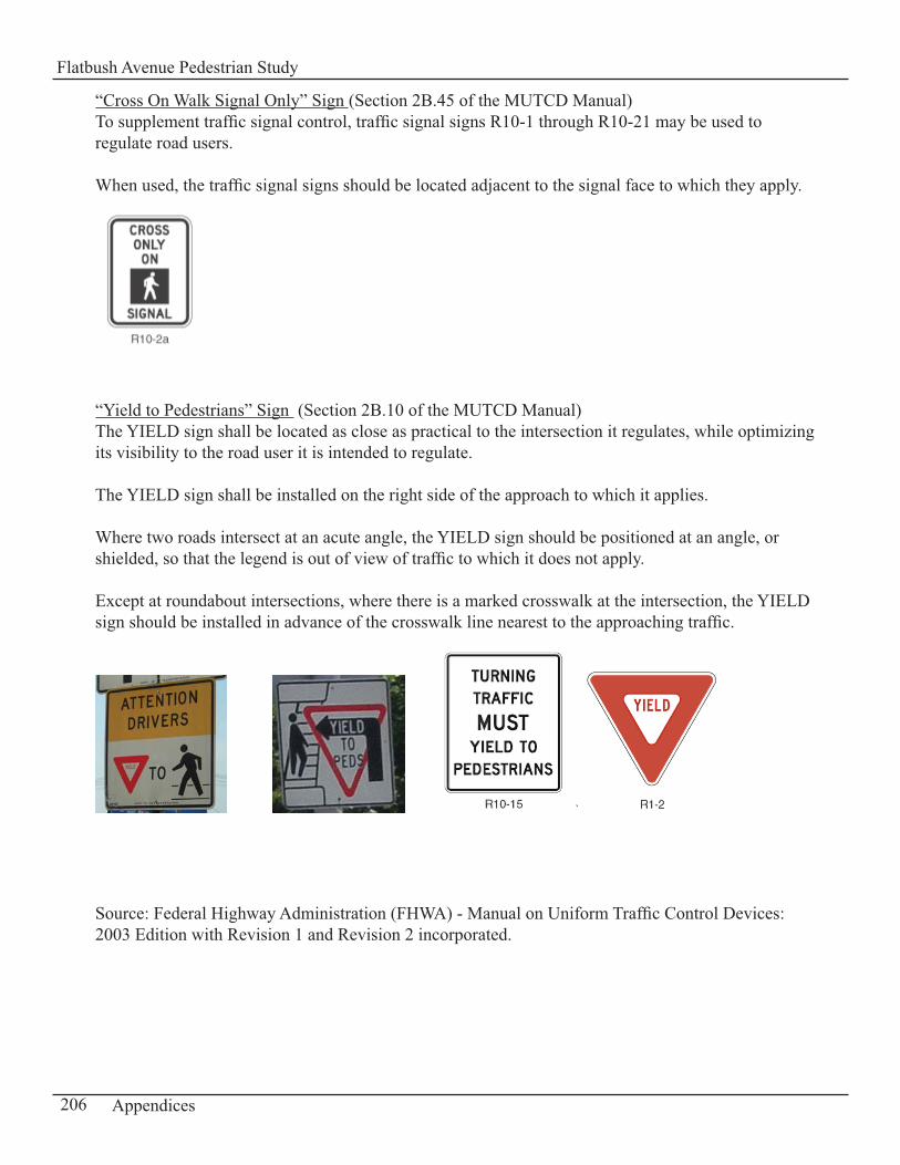
“Cross On Walk Signal Only” Sign (Section 2B.45 of the MUTCD Manual)To supplement traffic signal control, traffic signal signs R10-1 through R10-21 may be used to regulate road users.
When used, the traffic signal signs should be located adjacent to the signal face to which they apply.
“Yield to Pedestrians” Sign (Section 2B.10 of the MUTCD Manual)The YIELD sign shall be located as close as practical to the intersection it regulates, while optimizing its visibility to the road user it is intended to regulate.
The YIELD sign shall be installed on the right side of the approach to which it applies.
Where two roads intersect at an acute angle, the YIELD sign should be positioned at an angle, or shielded, so that the legend is out of view of traffic to which it does not apply.
Except at roundabout intersections, where there is a marked crosswalk at the intersection, the YIELD sign should be installed in advance of the crosswalk line nearest to the approaching traffic.
`
Source: Federal Highway Administration (FHWA) - Manual on Uniform Traffic Control Devices: 2003 Edition with Revision 1 and Revision 2 incorporated.
206 Appendices
Flatbush Avenue Pedestrian Study

207Appendices
Flatbush Avenue Pedestrian Study
208 Appendices
Flatbush Avenue Pedestrian Study
Appendix D-3:Standards for Bus Shelters
Bus Shelter Site Specifications Managed by Cemusa through the Coordinated Street Furniture Franchise, the New York City Department of Transportation has developed a set of site specifications for the placement of bus shelters on the sidewalks throughout the city. Bus shelters are available in four sizes (Standard: 14’x 5’, Narrow: 14’x 3.5’, Short: 10’x 5’, Double: 27’ x 5’) to accommodate various sidewalk widths.
Listed below are the siting criteria developed by the New York City Department of Transportation:Clear Path:1.
Bus Shelters shall be installed to allow a minimum clear path of 7feet in width. In no case shall such clear path be less than 5 feet in width. The clear path for a bus shelter may include the area covered by the bus shelter’s roof overhang, provided such overhang is a minimum of 7 ½ feet high.
Clearance from Curb: 2. All bus shelters shall be installed to allow a straight unobstructed path of a minimum of 3 feet in width between the shelter and the curb. The roof of a bus shelter including any overhang shall be set back from the curb line a minimum distance of 2 feet.
Relation to the Bus Stop: 3. All bus shelters shall be located as close as possible to the head of the bus stop, but no a) less than 10 feet from the head of the bus stop at locations where parking is permitted immediately adjacent to the head of the bus stop.If a bus shelter has only one enclosed end, it should be situated toward the head of the b) bus stop.
Other Minimum Distances:4. All bus shelters shall be:
10 feet from fire hydrants, standpipesa) 7 feet from tree trunksb) 5 feet from tree pits, cellar doorsc) 3 feet from streetlights, traffic signal polesd) 2 feet from ventilation, street signse)
Source: New York City Department of Transportation,
209Appendices
Flatbush Avenue Pedestrian Study
210 Appendices
Flatbush Avenue Pedestrian Study
Appendix D-4:Tree Planting Guidelines
Standard Tree Planting Guidelines
Tree Spacing RequirementsThe following Tree Planting Standards have been provided by the New York City Department of Parks and Recreation. All of these guidelines shall be observed when siting tree pits along sidewalks. These guidelines generally follow regulations of other agencies with street jurisdictions such as Fire, DOT, and MTA. These guidelines are design and species dependent.
Do not plant in front of building entrances in order to permit easy access by the Fire Department.• Minimum distance between trees (center to center) ranges from 20’ to 40’, depending on the tree • species and other local conditions.Minimum distance from a streetlight is 25’ (varies with tree species).• Minimum distance from a stop sign is 30’.• Minimum distance from other traffic signs is 6’.• Suggested distance from a parking meter is no more than 5’ behind the meter, to allow for the • swing of the car doors.Minimum distance from a gas or water valve is 2’ from the edge of the pit.• Minimum distance from an oil fill pipe is 4’ from the edge of the pit.• Minimum distance from a fire hydrant is 5’ from the edge of the pit.• Minimum distance from a curb cut or driveway is 7’.• Minimum distance from a street intersection is 40’. • Minimum distance from the edge of the pit to any opposite obstruction (building wall, stoop, • railing, etc) is from 4’ to 6’, depending upon local conditions and the amount of sidewalk traffic.All tree pits must be contiguous to the street curb (except as noted below, or with the permission • of the Agency representative). Do not plant within bus stops.•
Tree Pit ConfigurationThe minimum allowable tree pit sizes are 5’ x 5’, or 4’ by 6’ for narrow sidewalks. Larger pit sizes should be created wherever space allows, especially where larger trees are planted. On a wide sidewalk, 5’x10’ is the standard pit size. Below is a sample of a tree pit configuration sheet.
Source: New York City Department of Parks and Recreation
211Appendices
Flatbush Avenue Pedestrian Study
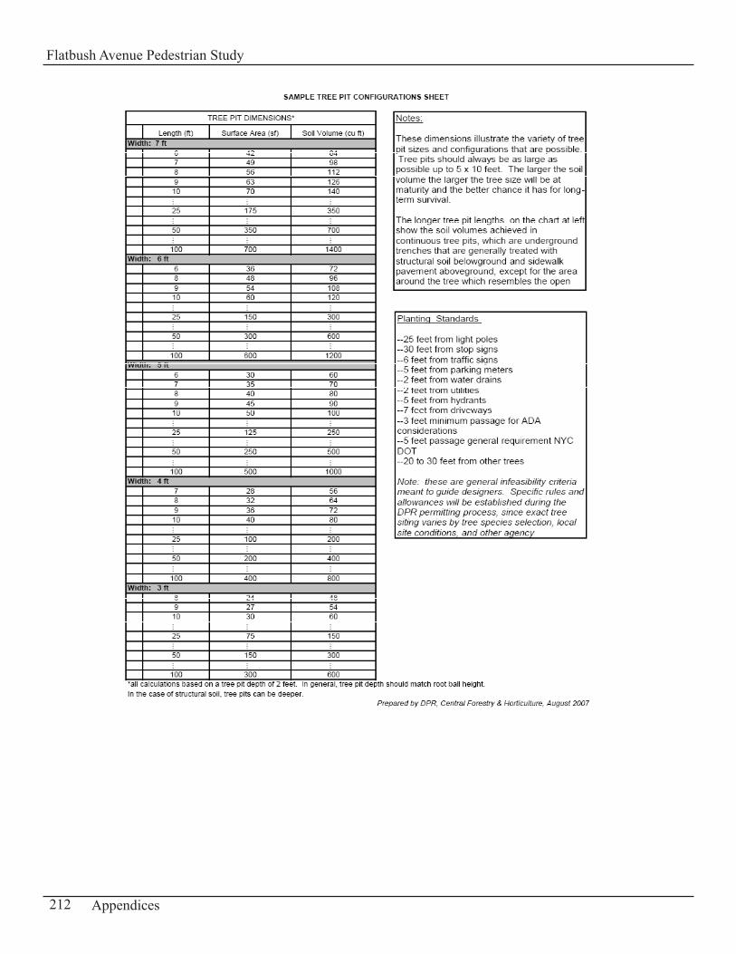
212 Appendices
Flatbush Avenue Pedestrian Study

213Appendices
Flatbush Avenue Pedestrian Study
214 Appendices
Flatbush Avenue Pedestrian Study
Appendix D-5:Literature Search
A review of previous and current relevant studies, documents, reports was done in order to identify from the literature any known pedestrian problem areas within the study area. In addition a review of pedestrian studies of other similar geographical locations was undertaken for the purpose of determining and analyzing project elements that may be relevant to this pedestrian study. Finally an examination of the statements of Community Districts Needs for the fiscal year 2006 was completed to determine any known pedestrian problem areas along the Flatbush Avenue corridor, within the limits of the study area.
215Appendices
Flatbush Avenue Pedestrian Study
Title: Brooklyn Retail Corridors
Author: New York City Department of City Planning and New York City Department of Transportation
Date: July 2003
Synopsis: Section 5.d. Flatlands (Level of Service/Accident Analysis and Recommendations) This study examines and focuses on traffic and pedestrian congestion and safety issues in four retail corridors in the borough of Brooklyn which includes Flatlands, Kings Plaza Shopping Center at Flatbush Avenue and Avenue U.
According to this study, overall this intersection operates at a LOS D for the three weekday peak periods and at LOS E for the weekend peak period. All sidewalks, crosswalks and corners operate at acceptable levels for all peak periods. Accident data for this area suggest that large turning volumes, signal timing/phasing and pedestrian traffic may all be contributing factors to the type of accidents that occur at this intersection.
Issues/ Problems Pedestrian Crossings Pedestrians at the east-west crosswalks ignore crossing signals and begin crossing whenever there is a gap in traffic. Those crossing north-south with the signal often encounter conflicts with northbound right turning vehicles and pedestrians often are forced to wait on a center median which is not wide enough.
Midblock CrossingsPedestrians cross Flatbush Avenue midblock between Avenue U and Avenue V to enter the shopping mall.
Public PlazaThe large plaza in front of the shopping mall does not have pedestrian amenities and lacks a bus shelter. Recommendations in terms of these issues are summarized below:
• On Avenue U, add stop bars to discourage vehicles from encroaching upon the crosswalk• Have two exclusive left-turn lanes instead of one exclusive left-turn lane for northbound
and southbound vehicular traffic• Adjust the signal timing during the weekend peak period to reduce delays• Install a pedestrian separator on Flatbush Avenue between Avenue U and V to prevent
midblock crossings; Relocate the bus stop in the middle of the block (west side of street) to the corner of Flatbush Avenue at Avenue U
• An “Early Implementation Plan” redesigns the plaza as an off-street transit center with bus shelters and other pedestrian amenities
216 Appendices
Flatbush Avenue Pedestrian Study
Title: Safe Streets NYC Study (Traffic Safety Improvements in New York City)
Author: New York City Department of Transportation
Date: April 2006
Synopsis:New York City Department of Transportation (NYCDOT) has accelerated its efforts over the past few years to improve pedestrian and traffic safety by instituting a systematic approach to the identification of locations throughout the city where innovative safety mitigation measures can be implemented. The focus of this study is to identify the top twenty locations and/or intersections which have experienced the highest number of accidents from 1996 to 2001 in New York City and to improve pedestrian and traffic safety at those locations.
Locations with similar geographical locations as the Flatbush Avenue Pedestrian Study are identified and analyzed for project elements that are relevant to the Flatbush Avenue Pedestrian Study. One of these locations is the Fulton Street Corridor located in the Downtown Brooklyn area where NYCDOT has recently instituted safety strategies and measures based on the needs of the area.
Fulton Street Corridor (Flatbush Avenue to Nostrand Avenue)It is a major east-west commercial corridor in Brooklyn and is host to numerous street users. The orientation of Fulton Street in relation to the surrounding street grid form “oblique” angles at these intersections which create safety and operational issues for pedestrians and general traffic.
A few locations such as Hanson Place, Putnam Avenue and Gates Avenue were subject to analysis in the “Safe Streets” study and were improved with the implementation of innovative safety measures. Below is a description of the issues identified at these locations in relation to pedestrians and the improvements made to enhance pedestrian safety.
With the oblique angles, turning vehicles would sometimes proceed through the intersection at high speeds and create conflict with pedestrians crossing. NYCDOT eliminated this conflict through the conversion of the intersection to right angles with the use of markings and flexible bollards. The lengths of the crosswalks were significantly reduced and pedestrian space expanded.
Other treatments were installed along Fulton Street at other locations such as Carlton Avenue, Downing Street, Irving Place Spencer Place etc. These treatments consisted of painted neckdowns and flexible bollards to slow down turning vehicles and alert motorists to the changing street character.
Several crosswalks at intersections with high pedestrian activity along Fulton Street have been updated to high-visibility crosswalks in order to meet current DOT’s standards. In addition Wide Turning Zones (WTZ) was established to permit general traffic to turn on and off Fulton Street. They include signage advising pedestrians of turning vehicles at Wide Turn Zones.
Although many of the mitigation measures were implemented with temporary materials, NYCDOT plans to convert the new pedestrian space and improvements into sidewalk space in the near future.
217Appendices
Flatbush Avenue Pedestrian Study
Title: Streetscape and Pedestrian Improvements in New York City (Technical Memorandum I)
Author: New York City Department of City Planning
Date: N/A
Synopsis: This report discusses the streetscape improvements in many areas of New York City including Downtown Flushing. This study also provides a description of the streetscape elements and treatments that are employed and explains the success of these improvements in different parts of the city with the intent to identify potential aids and impediments to the realization of the Downtown Flushing Pedestrian Project. Many of the improvements proved beneficial to the pedestrian environment, increasing pedestrian safety and movement in the area, as well as improving its appearance.
Here is a summary of the streetscape elements described in the report and were used in many streetscape improvement projects throughout the city:
Traffic Calming Devices - To better serve the non-motorized users and the environment, traffic should be slowed down (less noise, less fumes). Design methods that can accomplish this: sidewalk extensions, speed humps and changes in road surface.
Corners and Crosswalks - Here are a few design methods recommended at the corners and crosswalks: Have “Clear Corner Zones” – space allocated at corners that require to be free of excess elements; “Distinct Corners” – set apart from the sidewalk by the paving material or pattern which can reinforce the identity of an area; “Crosswalks – at heavily traveled locations use high-visibility crosswalks; “Barnes Dance Crosswalk” – addresses signal timing that gives a head start to pedestrians as they cross the street.
Sidewalks and Curbs - Use of standard or distinctive sidewalks and curbs generally in New York City. A maintenance agreement must be reached before approval is granted for a distinctive sidewalk.
Street Lighting - Standard street light fixtures are generally used. They also have equipment that is available for certain specific areas and streets, for example the “Flatbush Lamppost and Teardrop Luminaire” are used on Main St. in Flushing.
Banners on Street Light Poles - Banners are usually attached to lampposts and are regulated by NYCDOT in terms of dimensions, height, support and installation. They are generally maintained by a merchant’s association or BID.
Signage - The Manual on Uniform Traffic Control Devices (MUTCD) has set the standard for signs and usually they are geared towards drivers and on-street users. Off-street signage can deviate from standards.
Street Trees and Accessories - NYCDPR sets the standards. Accessories include tree grates, tree guards or other types of tree pit design. Beyond city standards a maintenance agreement must be reached before a street tree permit is granted.
218 Appendices
Flatbush Avenue Pedestrian Study
Other streetscape elements include street furniture (trash receptacles, benches) and art such as sculpture, murals, gateways etc.
According to this study there have been a number of streetscape improvement projects implemented in Downtown Flushing. A complete list is provided in Appendix C of the report. It includes improvements along Prince Street, Main Street and Union Street with granite curbs, trees, new standard sidewalks etc. and improvements to the Lippmann Plaza.
As part of this study many streetscapes were visited and considered to be a success such as Grand Central, 82nd Street (Jackson Heights), 61st Street (Woodside), etc. The most important factor identified as contributing to these projects success was the maintenance of the streetscape. Safety and security was another major issue that affected the success of a streetscape. If people feel a lack of safety or security they will not visit a certain area. Certain streetscape elements make a strong contribution to the overall success of a streetscape: for example a crosswalk marked with brick pavers provide a clear and visible crossing for pedestrians, sidewalk extensions etc.
219Appendices
Flatbush Avenue Pedestrian Study
Title: 14th Street Transportation Study
Author: New York City Department of City Planning, Transportation Division
Date: April 1998
Synopsis:The 14th Street Transportation Study was conducted to examine the effects of new developments in Union Square and on 14th Street, east of the park. The analysis focused on intersections that were either unsafe or would be directly affected by the new development.
The pedestrian traffic analysis identified the following circulation issues for pedestrians:• Inappropriate curb use and a lack of enforcement of curbside regulations cause buses and
delivery trucks to double park and obstruct crosswalks and moving lanes along 14th Street.• Bicycles locked to street signs partially block crosswalk entrances. • A lack of enforcement of the Mayor’s 1995 Executive Order no.22 which authorized
sidewalk corner clearance policy. A combination of news boxes and garbage cans were obstructing several crosswalk entrances and queuing areas for crossing pedestrians. Pedestrians were then observed forming queues in the road and walking outside designated crosswalks.
• Pedestrians often conflict with vehicles turning left and right along 14th Street at several intersections. The situation worsens when intervals of heavy pedestrian traffic occurs.
• At the corners during some of the congested intervals, limited corner queuing space was available for pedestrians waiting to cross, resulting in queuing off the curb in the street.
• Some of the crosswalks were faded or in poor condition.
The following recommendations are suggested in this study to address the problems that pedestrians often encounter along 14th Street:
• Give pedestrians a few seconds head start over vehicles turning• Provide exclusive turning time for left turns at selected locations while pedestrians are not
walking• Restripe or repaint faded crosswalks• Have a stop bar before crosswalk at locations where pedestrians are often forced to dodge
cars stopped in the crosswalk• Widen crosswalks when necessary • Install a neckdown at the corner where needed• Reduce corner clutter where needed: have newspaper boxes other items blocking
crosswalk entrance removed
220 Appendices
Flatbush Avenue Pedestrian Study
COMMUNITY DISTRICT NEEDS OF BROOKLYNCD#9, CD#14, CD#18
The study area lies within three Community Districts of the borough of Brooklyn:• Community District #9• Community District #14• Community District #18
Community District #9
1. The recommendations are for the community beautification plan. The greening of traffic triangles and city-owned vacant lots to create vest-pocket parks are all components of this plan. Beautifying our neighborhood streets with the planting of street trees is a top priority.
2. The reconstruction of Empire Boulevard from Flatbush to Utica Ave. This route suffers from flooding and drainage problems which affects pedestrians.
Community District # 14
1. Focus on traffic planning in congested commercial stripes along the Flatbush corridor with the need to develop programs for expansion of sidewalk façade improvement programs for these commercial streets.2. The continuation of funding for programs to repair sidewalks along the Flatbush Corridor.
Community District # 18
Transportation issues continue to be a top concern for the community board. The intersections around the Kings Plaza Shopping Center are mentioned in the Community Board #18 Statement of Needs document as examples of locations that present safety issues for pedestrian/vehicular traffic that they request to be addressed. A coordinated effort must be made to implement identified solutions for safer streets and pedestrian crossings. So far to date according to the community board nothing of consequence has been done.
221Appendices
Flatbush Avenue Pedestrian Study
CreditsNew York City Department of City PlanningAmanda M. Burden, AICP, DirectorRichard Barth, Executive DirectorSandy Hornick, Deputy Executive Director for Strategic Planning
Transportation DivisionJack Schmidt, DirectorKevin Olinger, Deputy DirectorStratos Prassas, Team LeaderLise Dorestant, Project ManagerDekka Michael, City PlannerDavid Aigner, City PlannerAlan Ripps, City PlannerSeth Hostetter, City PlannerKenneth Laidlow, Highway Transportation SpecialistMichelle Katopodes, City Planner
Brooklyn OfficePurnima Kapur, DirectorWinston Von Engel, Deputy DirectorDavid Parish