Embed Size (px)
Citation preview
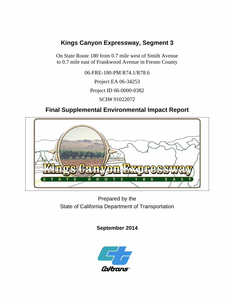
Kings Canyon Expressway, Segment 3
On State Route 180 from 0.7 mile west of Smith Avenue to 0.7 mile east of Frankwood Avenue in Fresno County
06-FRE-180-PM R74.1/R78.6
Project EA 06-34253
Project ID 06-0000-0382
SCH# 91022072
Final Supplemental Environmental Impact Report
Prepared by the
State of California Department of Transportation
September 2014

General Information About This Document Appendix D (Comments and Responses) has been added to the document since the draft
document was circulated for review and comment. Elsewhere, a line in the margin indicates
where an addition or change has been made since the draft document was circulated.
Printing this document: To save paper, we set up this document for two-sided printing (to print
the front and back of a page). Blank pages (or diamond symbols on pages) occur where needed
throughout the document to maintain proper layout of the sections.
For individuals with sensory disabilities, this document is available in Braille, in large print, on audiocassette, or on computer disk. To obtain a copy in one of these alternate formats, please call or write to Caltrans, Attn: Michelle Ray, Senior Environmental Planner, Sierra Pacific Environmental Analysis Branch, 855 M Street, Suite 200, Fresno, CA 93721; (559) 445-5286, or 711.
Kings Canyon Expressway Segment 3 i
SCH# 91022072 06-FRE-180-PM R74.1/R78.6
EA 06-34253 Project ID 06-0000-0382
On State Route 180 from 0.7 mile west of Smith Avenue to 0.7 mile east of Frankwood Avenue in Fresno County
FINAL SUPPLEMENTAL ENVIRONMENTAL IMPACT REPORT
Submitted Pursuant to: (State) Division 13, California Public Resources Code
THE STATE OF CALIFORNIA
Department of Transportation

Kings Canyon Expressway Segment 3 iii
Summary
This final environmental document for Segment 3 of the Kings Canyon Expressway
(FRE180-EA06-34253) is a supplemental report to the previously prepared and certified
State Route 180 Improvement Project Final Environmental Impact Report (September
1995, State Clearinghouse Number 91022072). This Final Supplemental Environmental
Impact Report (FSEIR) presents additional analysis or information in regard to parks and
recreational facilities, relocations, utilities/emergency services, traffic/pedestrian and
bicycle facilities, climate change, and biological impacts (natural communities, wetlands
and other waters, and threatened and endangered species), resulting from changes to the
design of the project and new laws or regulations.
State Route 180 is the main east-west highway in eastern Fresno County, connecting the
Fresno-Clovis metropolitan area to Kings Canyon National Park and Sequoia National
Park, as well as other rural recreational areas in the western Sierra Nevada Mountains.
The route passes through the unincorporated rural communities of Centerville and
Minkler and is important for moving agricultural goods from ranches and farms east of
Fresno. State Route 180 also serves the commuter traffic coming from the developed
foothill communities of Tivy Valley, Wonder Valley and Squaw Valley, as well as the
many residential developments along the Kings River. State Route 180 provides one of
the main crossings of the Kings River in the county.
The project corridor remains as described in the 1995 Final Environmental Impact Report
(FEIR). The existing alignment of State Route 180 crosses the floodplain of the Kings
River, and the surrounding rural area is used mainly for grazing with some low-density
housing and small commercial operations. Exceptions are the small communities of
Centerville, Minkler, and a large sand/rock excavation company south of the existing
route on the west side of the Kings River.
The existing State Route 180 crosses the Kings River in a location where the forks of the
river merge together and there is one body of water to cross. The 1995 Preferred
Alternative remains the least environmentally damaging practicable alternative (LEDPA)
largely due to this existing environmental setting. The California Department of
Transportation (Caltrans) has conducted ongoing environmental studies for the project in
recent years and has determined that crossing the Kings River in a location farther north
or south would result in an increase of impacts to biological resources and
residential/commercial developments.
Summary
Kings Canyon Expressway Segment 3 iv
The proposed project is the third and last segment of a larger State Route 180 East
widening project (FRE180-EA06-34250). The original environmental document
evaluated the proposed improvements from Temperance Avenue to Cove Road (post
miles R65.6 to 84.0). The FEIR was approved on September 29, 1995, and construction
of the project was proposed in four phases. Due to differences in project scope, purpose
and need, scheduling, and funding, the project’s original Segment 4, from Alta Main
Canal to Cove Road, was dropped from consideration. Consequently, the expressway
would be constructed in only three phases.
A National Environmental Policy Act (NEPA) Reevaluation and California
Environmental Quality Act (CEQA) Addendum to File were approved in June 2004 for
Segments 1-3. These environmental documents primarily provided environmental
clearance for right-of-way acquisition and considered design changes related to
intersections of the expressway with local streets, Caltrans Highway Design Manual
standards, a utility corridor, and property access. The project description proposed
constructing a four-lane expressway from east of Temperance Avenue to east of
Academy Avenue, and a two-lane expressway on a four-lane right-of-way from east of
Academy Avenue to the Alta Main Canal.
A second NEPA Reevaluation and CEQA Addendum to File were approved in December
2005 for Segments 1-3. The 2005 environmental documents were necessary to update the
previous Biological Assessment submitted to the U.S. Fish and Wildlife Service. The
project description in the 2005 Reevaluation was the same as the one in the 2004 NEPA
Reevaluation citing that all construction phases are documented in the 1994 Regional
Transportation Plan and the 1994 Federal Transportation Improvement Program.
In spring 2011, the project limits of Segment 2 (FRE180-EA06-34252) were decreased to
avoid additional environmental impacts discovered during supplemental environmental
studies, and the portion of Segment 2 that was dropped was added to Segment 3. The
construction of Segment 1 was completed in fall 2011, and Segment 2 is currently under
construction.
Proposed Action
Segment 3 (FRE180-EA06-34253), the proposed project, will realign and widen State
Route 180 from 0.7 mile west of Smith Avenue to 0.7 mile east of Frankwood Avenue
(post miles R74.1 to R78.6) near the communities of Centerville and Minkler in eastern
Fresno County. The project will widen the existing two-lane conventional highway to a
four-lane divided expressway. This 4.5-mile segment will connect with the previously
Summary
Kings Canyon Expressway Segment 3 v
constructed Kings Canyon Expressway Segment 2 west of Smith Avenue (FRE180-
EA06-34252).
The project will provide intersections for major roads, drainage, signage, and shoulders
while maintaining or improving access for the local road network and community. The
project will require the acquisition of new right-of-way and the abandonment of some
existing State Route 180 right-of-way. The new alignment will cross grazing land and
will intersect with occasional business properties and residential homes. New crossings
will be constructed over the Centerville-Kingsburg Canal, China Slough, Collins Creek,
Kings River, Cameron Slough, Byrd Slough, Carmelita Ditch, and Mt. Campbell Ditch.
Segment 3 begins west of the Centerville-Kingsburg Canal, which runs diagonally across
the realignment of State Route 180. After crossing the canal, the project turns north of
Centerville to avoid eligible historical properties located adjacent to the existing State
Route 180 and then intersects with Oliver Avenue. Residents west of Oliver Avenue
would have access on a new frontage road. Trimmer Springs Road will no longer
intersect with State Route 180 and will be realigned to the west to connect with Oliver
Avenue. After intersecting with Oliver Avenue, the new alignment turns south and the
project constructs a new bridge over China Slough north of the existing crossing.
The project then parallels the existing alignment of State Route 180 past the Kings River.
Along the way, the new alignment will cross grazing land sprinkled with heritage oaks on
the north, woodlands to the south, and Collins Creek, which runs diagonally across the
proposed alignment of State Route 180 and the existing roadway. The large sand/rock
company and residents south of the existing alignment would use a new intersection at
Rio Vista Avenue for access, and a second bridge would be constructed north of the
existing bridge at Kings River. After crossing the Kings River, the project will intersect
Piedra Road, which will be realigned to improve sight distance. New frontage roads will
be constructed for residents located on the east side and west side of Piedra Road north of
State Route 180 for access.
After intersecting with Piedra Road, the new alignment no longer parallels the existing
State Route 180 but passes northeast of the small community of Minkler. The
realignment of this segment of the project is necessary to avoid an historical structure and
to eliminate several sharp turns. The new alignment will require construction of new
bridges over Cameron Slough and Byrd Slough. Reed Avenue will be extended northeast
beyond its current intersection with the existing State Route 180. New intersections will
Summary
Kings Canyon Expressway Segment 3 vi
be constructed at the new State Route 180 and extended Reed Avenue and Frankwood
Avenue. Past Frankwood Avenue, the new alignment will connect with the existing
alignment of State Route 180 before reaching the Alta Main Canal. Segments of the
existing State Route 180 will be converted into frontage or access roads.
California Environmental Quality Act Document
The project is subject to state environmental review requirements and has been prepared
in compliance with the California Environmental Quality Act. Caltrans is the lead agency
under the California Environmental Quality Act. Following receipt of public comments
on the draft Supplemental Environmental Impact Report and circulation of the final
Supplemental Environmental Impact Report, Caltrans will be required to take actions
regarding the environmental document and will determine whether to certify the
Supplemental Environmental Impact Report and issue Findings and a Statement of
Overriding Considerations under the California Environmental Quality Act.
However, because funding for the proposed project includes federal funds, a National
Environmental Policy Act Revalidation will be prepared after circulation and public
comment of this document. Impacts determined significant under the California
Environmental Quality Act may not lead to a determination of significance under the
National Environmental Policy Act. Because the National Environmental Policy Act is
concerned with the significance of the project as a whole, it is quite often the case that a
“lower level” document is prepared for the National Environmental Policy Act.
Summary of Changes
Caltrans has made several design changes to Segment 3 from how the segment was
described in the 1995 environmental document. These changes relate to intersections of
the expressway with local streets, Caltrans design standards, utility corridors, and
property access. Changes in the design or scope of Segment 3 include the following:
Beginning at 0.7 mile west of Smith Avenue (post mile R74.1) to include a
portion of Segment 2 that was dropped for advanced project delivery.
Constructing a four-lane expressway instead of a two-lane limited access highway
on a four-lane right-of-way as stated in the 1995 Environmental Impact Report.
Constructing a 62-foot median as reported in the 2004 and 2005 Environmental
Reevaluations.
Summary
Kings Canyon Expressway Segment 3 vii
Acquiring a utility easement to consolidate the existing utilities along the north
side of the new alignment.
Acquiring Private Vehicle Access Easements (PVAE) for utility and private
access easements to keep properties from becoming “land-locked.”
Raising the profile (height) of the roadway at the Kings River, Cameron Slough,
and Byrd Slough to achieve a mandated 3-foot clearance between high water and
bottom of the bridge (also known as freeboard).
Removing a temporary intersection 0.7 mile west of Smith Avenue and a
temporary cul-de-sac 0.2 mile west of Smith Avenue constructed for Segment 2.
Adding left-turn lanes for northbound and southbound traffic at the intersections
of Piedra Road and Oliver, Rio Vista, Reed and Frankwood avenues.
Realigning Oliver Avenue slightly to the east to avoid an eligible historic
building.
Adding frontage roads for access to the north side of State Route 180 west of
Oliver Avenue, west of Piedra Avenue, and east of Frankwood Avenue.
Eliminating the direct connection of Trimmer Springs Road to State Route 180
(Caltrans Highway Design Manual requirements for intersection spacing).
Realigning Trimmer Springs Road to connect to Oliver Avenue.
Constructing a bridge over China Slough instead of using a box culvert.
Adding a cul-de-sac to the existing State Route 180 east of Collins Creek.
Adding right-turn-only lanes with through bicycle lanes on eastbound State Route
180 at Rio Vista and Reed avenues.
Adding eastbound and westbound acceleration lanes at Rio Vista Avenue.
Adding a traffic signal at Reed Avenue.
Extending the box culverts at the Centerville-Kingsburg Canal and Collins Creek
for frontage roads and private vehicle access easements.
Summary
Kings Canyon Expressway Segment 3 viii
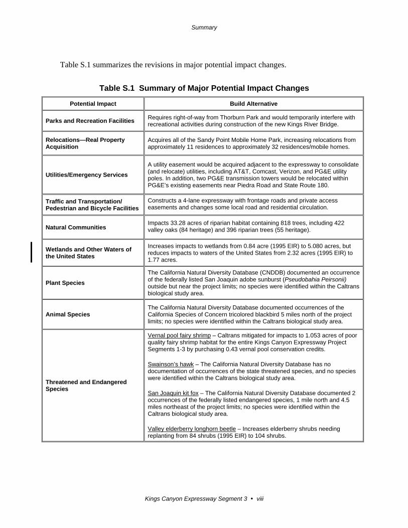
Table S.1 summarizes the revisions in major potential impact changes.
Table S.1 Summary of Major Potential Impact Changes
Potential Impact Build Alternative
Parks and Recreation Facilities Requires right-of-way from Thorburn Park and would temporarily interfere with recreational activities during construction of the new Kings River Bridge.
Relocations—Real Property Acquisition
Acquires all of the Sandy Point Mobile Home Park, increasing relocations from approximately 11 residences to approximately 32 residences/mobile homes.
Utilities/Emergency Services
A utility easement would be acquired adjacent to the expressway to consolidate (and relocate) utilities, including AT&T, Comcast, Verizon, and PG&E utility poles. In addition, two PG&E transmission towers would be relocated within PG&E’s existing easements near Piedra Road and State Route 180.
Traffic and Transportation/ Pedestrian and Bicycle Facilities
Constructs a 4-lane expressway with frontage roads and private access easements and changes some local road and residential circulation.
Natural Communities Impacts 33.28 acres of riparian habitat containing 818 trees, including 422 valley oaks (84 heritage) and 396 riparian trees (55 heritage).
Wetlands and Other Waters of the United States
Increases impacts to wetlands from 0.84 acre (1995 EIR) to 5.080 acres, but reduces impacts to waters of the United States from 2.32 acres (1995 EIR) to 1.77 acres.
Plant Species
The California Natural Diversity Database (CNDDB) documented an occurrence of the federally listed San Joaquin adobe sunburst (Pseudobahia Peirsonii) outside but near the project limits; no species were identified within the Caltrans biological study area.
Animal Species The California Natural Diversity Database documented occurrences of the California Species of Concern tricolored blackbird 5 miles north of the project limits; no species were identified within the Caltrans biological study area.
Threatened and Endangered Species
Vernal pool fairy shrimp – Caltrans mitigated for impacts to 1.053 acres of poor quality fairy shrimp habitat for the entire Kings Canyon Expressway Project Segments 1-3 by purchasing 0.43 vernal pool conservation credits. Swainson’s hawk – The California Natural Diversity Database has no documentation of occurrences of the state threatened species, and no species were identified within the Caltrans biological study area. San Joaquin kit fox – The California Natural Diversity Database documented 2 occurrences of the federally listed endangered species, 1 mile north and 4.5 miles northeast of the project limits; no species were identified within the Caltrans biological study area. Valley elderberry longhorn beetle – Increases elderberry shrubs needing replanting from 84 shrubs (1995 EIR) to 104 shrubs.
Summary
Kings Canyon Expressway Segment 3 ix
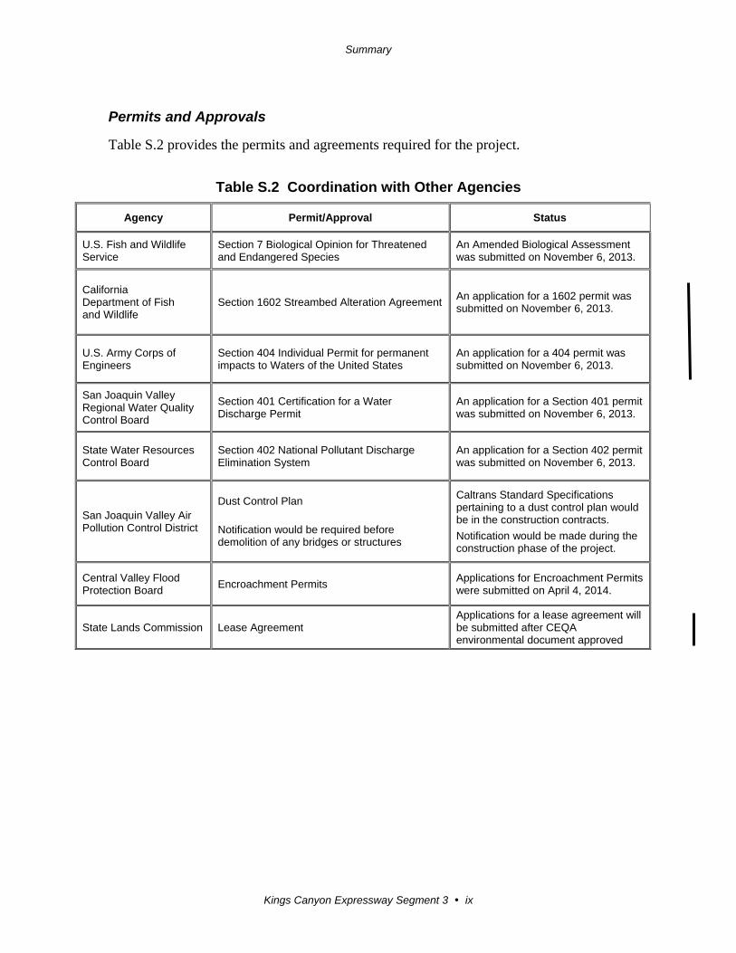
Permits and Approvals
Table S.2 provides the permits and agreements required for the project.
Table S.2 Coordination with Other Agencies
Agency Permit/Approval Status
U.S. Fish and Wildlife Service
Section 7 Biological Opinion for Threatened and Endangered Species
An Amended Biological Assessment was submitted on November 6, 2013.
California Department of Fish and Wildlife
Section 1602 Streambed Alteration Agreement An application for a 1602 permit was submitted on November 6, 2013.
U.S. Army Corps of Engineers
Section 404 Individual Permit for permanent impacts to Waters of the United States
An application for a 404 permit was submitted on November 6, 2013.
San Joaquin Valley Regional Water Quality Control Board
Section 401 Certification for a Water Discharge Permit
An application for a Section 401 permit was submitted on November 6, 2013.
State Water Resources Control Board
Section 402 National Pollutant Discharge Elimination System
An application for a Section 402 permit was submitted on November 6, 2013.
San Joaquin Valley Air Pollution Control District
Dust Control Plan
Notification would be required before demolition of any bridges or structures
Caltrans Standard Specifications pertaining to a dust control plan would be in the construction contracts.
Notification would be made during the construction phase of the project.
Central Valley Flood Protection Board
Encroachment Permits Applications for Encroachment Permits were submitted on April 4, 2014.
State Lands Commission Lease Agreement Applications for a lease agreement will be submitted after CEQA environmental document approved

Kings Canyon Expressway Segment 3 xi
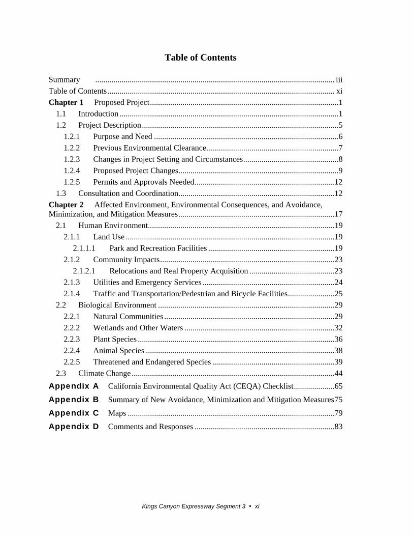
Table of Contents
Summary ...................................................................................................................... iii
Table of Contents ................................................................................................................ xi
Chapter 1 Proposed Project ............................................................................................. 1
1.1 Introduction ............................................................................................................ 1
1.2 Project Description ................................................................................................. 5
1.2.1 Purpose and Need ........................................................................................... 6
1.2.2 Previous Environmental Clearance ................................................................. 7
1.2.3 Changes in Project Setting and Circumstances ............................................... 8
1.2.4 Proposed Project Changes............................................................................... 9
1.2.5 Permits and Approvals Needed ..................................................................... 12
1.3 Consultation and Coordination ............................................................................. 12
Chapter 2 Affected Environment, Environmental Consequences, and Avoidance, Minimization, and Mitigation Measures ............................................................................. 17
2.1 Human Environment ............................................................................................ 19
2.1.1 Land Use ....................................................................................................... 19
2.1.1.1 Park and Recreation Facilities .............................................................. 19
2.1.2 Community Impacts ...................................................................................... 23
2.1.2.1 Relocations and Real Property Acquisition .......................................... 23
2.1.3 Utilities and Emergency Services ................................................................. 24
2.1.4 Traffic and Transportation/Pedestrian and Bicycle Facilities ....................... 25
2.2 Biological Environment ....................................................................................... 29
2.2.1 Natural Communities .................................................................................... 29
2.2.2 Wetlands and Other Waters .......................................................................... 32
2.2.3 Plant Species ................................................................................................. 36
2.2.4 Animal Species ............................................................................................. 38
2.2.5 Threatened and Endangered Species ............................................................ 39
2.3 Climate Change .................................................................................................... 44
Appendix A California Environmental Quality Act (CEQA) Checklist .................... 65
Appendix B Summary of New Avoidance, Minimization and Mitigation Measures 75
Appendix C Maps ...................................................................................................... 79
Appendix D Comments and Responses ..................................................................... 83
Kings Canyon Expressway Segment 3 xii
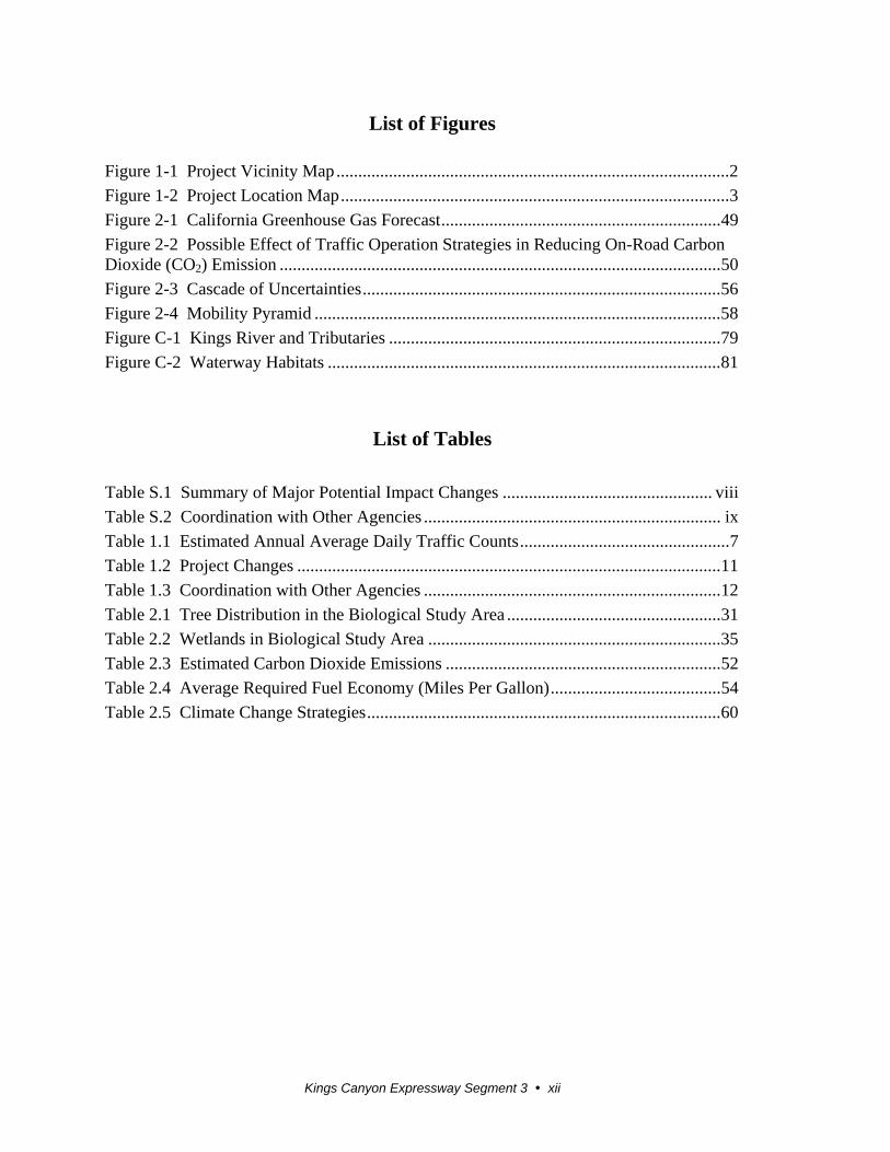
List of Figures
Figure 1-1 Project Vicinity Map .......................................................................................... 2
Figure 1-2 Project Location Map ......................................................................................... 3
Figure 2-1 California Greenhouse Gas Forecast ................................................................ 49
Figure 2-2 Possible Effect of Traffic Operation Strategies in Reducing On-Road Carbon Dioxide (CO2) Emission ..................................................................................................... 50
Figure 2-3 Cascade of Uncertainties .................................................................................. 56
Figure 2-4 Mobility Pyramid ............................................................................................. 58
Figure C-1 Kings River and Tributaries ............................................................................ 79
Figure C-2 Waterway Habitats .......................................................................................... 81
List of Tables
Table S.1 Summary of Major Potential Impact Changes ................................................ viii
Table S.2 Coordination with Other Agencies .................................................................... ix
Table 1.1 Estimated Annual Average Daily Traffic Counts ................................................ 7
Table 1.2 Project Changes ................................................................................................. 11
Table 1.3 Coordination with Other Agencies .................................................................... 12
Table 2.1 Tree Distribution in the Biological Study Area ................................................. 31
Table 2.2 Wetlands in Biological Study Area ................................................................... 35
Table 2.3 Estimated Carbon Dioxide Emissions ............................................................... 52
Table 2.4 Average Required Fuel Economy (Miles Per Gallon) ....................................... 54
Table 2.5 Climate Change Strategies ................................................................................. 60
Kings Canyon Expressway Segment 3 1
Chapter 1 Proposed Project
1.1 Introduction
The California Department of Transportation (Caltrans) is the lead agency for this project
under the California Environmental Quality Act (CEQA).
This final environmental document is a supplemental report to the previously prepared
and certified State Route 180 Improvement Project Final Environmental Impact Report
(September 1995, State Clearinghouse Number 91022072). This Final Supplemental
Environmental Impact Report (FSEIR) presents additional analysis or information in
regard to parks and recreational facilities, relocations, utilities/emergency services,
traffic/pedestrian and bicycle facilities, climate change, and biological impacts (natural
communities, wetlands and other waters, and threatened and endangered species),
resulting from changes to the design of the project and new laws or regulations. Since
1995, additional environmental clearances under the California Environmental Quality
Act and National Environmental Policy Act have been completed for this project and are
discussed in Section 1.2.2 of this document.
Following receipt of public comments on the Draft Supplemental Environmental Impact
Report and circulation of the Final Supplemental Environmental Impact, Caltrans will be
required to take actions regarding the environmental document and will determine
whether to certify the report and issue Findings and a Statement of Overriding
Considerations under the California Environmental Quality Act. Because funding for the
proposed project includes federal funds, a National Environmental Policy Act
Revalidation will be prepared after circulation and public comment of this document.
Impacts determined significant under the California Environmental Quality Act may not
lead to a determination of significance under the National Environmental Policy Act.
Because the National Environmental Policy Act is concerned with the significance of the
project as a whole, it is quite often the case that a “lower level” document is prepared for
the National Environmental Policy Act.
Chapter 1 Proposed Project
Kings Canyon Expressway Segment 3 2
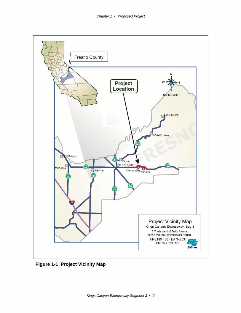
Figure 1-1 Project Vicinity Map

Chapter 1 Proposed Project
Kings Canyon Expressway Segment 3 3
Figure 1-2 Project Location Map

Chapter 1 Proposed Project
Kings Canyon Expressway Segment 3 5
1.2 Project Description
Segment 3 of the Kings Canyon Expressway Project will realign and widen a 4.5-mile
segment of State Route 180 near the rural communities of Centerville and Minkler in
eastern Fresno County (see Figure 1-1). The project begins at 0.7 mile west of Smith
Avenue and ends 0.7 mile east of Frankwood Avenue (post miles R74.1 to R78.6) and
will connect with the previously constructed Kings Canyon Expressway Segment 2 west
of Smith Avenue (FRE180-EA06-34252). The new alignment will widen the existing
two-lane conventional highway to a four-lane divided expressway (see Figure 1-2). The
purpose of the project is to improve continuity, safety, and capacity along State Route
180 to and from Fresno and areas east.
The project will provide intersections for major roads, drainage, signage, and shoulders
while maintaining or improving access for the local road network and community. The
project will require the acquisition of new right-of-way and the abandonment of some
existing State Route 180 right-of-way. The new alignment will cross agricultural land and
will intersect with occasional business properties and residential homes. New crossings
will be constructed over the Centerville-Kingsburg canal, China Slough, Collins Creek,
Kings River, Cameron Slough, Byrd Slough, Carmelita Ditch, and Mt. Campbell Ditch.
Segment 3 begins west of the Centerville-Kingsburg Canal, which runs diagonally across
the realignment of State Route 180. After crossing the canal, the project turns north of
Centerville to avoid eligible historical properties next to the existing State Route 180 and
intersects with Oliver Avenue. Residents west of Oliver Avenue will have access via a
new frontage road. Trimmer Springs Road will no longer intersect with State Route 180
and will be realigned to the west to connect with Oliver Avenue. After intersecting with
Oliver Avenue, the new alignment turns south and the project constructs a new bridge
over China Slough north of the existing crossing.
The project then parallels the existing alignment of State Route 180 past the Kings River.
Along the way, the new alignment will cross grazing land sprinkled with heritage oaks on
the north, woodlands to the south, and Collins Creek, which runs diagonally across the
proposed alignment of State Route 180 and the existing roadway. The large sand/rock
company and residents south of the existing alignment will use a new intersection at Rio
Vista Avenue for access, and a second bridge will be constructed north of the existing
bridge at Kings River. After crossing the Kings River, the project will intersect Piedra
Road, which will be realigned to improve sight distance. New frontage roads will be
Chapter 1 Proposed Project
Kings Canyon Expressway Segment 3 6
constructed for residents on the east side and west side of Piedra Road north of State
Route 180 for access.
After intersecting with Piedra Road, the new alignment no longer parallels the existing
State Route 180 but passes northeast of the small community of Minkler. The
realignment of this segment of the project is necessary to avoid an historical structure and
to eliminate several sharp turns. The new alignment will require construction of new
bridges over Cameron Slough and Byrd Slough. Reed Avenue will be extended northeast
beyond its current intersection with the existing State Route 180. New intersections will
be constructed at the new State Route 180 and extended Reed Avenue and Frankwood
Avenue. Past Frankwood Avenue, the new alignment will connect with the existing
alignment of State Route 180 before reaching the Alta Main Canal. Segments of the
existing State Route 180 will be converted into frontage or access roads.
1.2.1 Purpose and Need
According to the 1995 Environmental Impact Report, the purpose of the project is to
facilitate safe vehicle operation on State Route 180 and improve the capacity of the
highway. The project need included highway deficiencies at several locations in the
project area that were not built to current Caltrans Highway Design Standards, such as
horizontal and vertical alignments, lane widths, shoulder widths, and sight distances.
These deficiencies resulted in low operating speeds, inadequate passing opportunities,
and higher-than-average accident rates. In addition, the existing highway had insufficient
capacity for future project traffic volumes.
Future project traffic volumes have increased beyond the estimated volumes discussed in
the 1995 Environmental Impact Report, however. The estimated traffic volume for the
future year (2010) was based on data prepared by the Fresno County Council of
Governments and Caltrans.
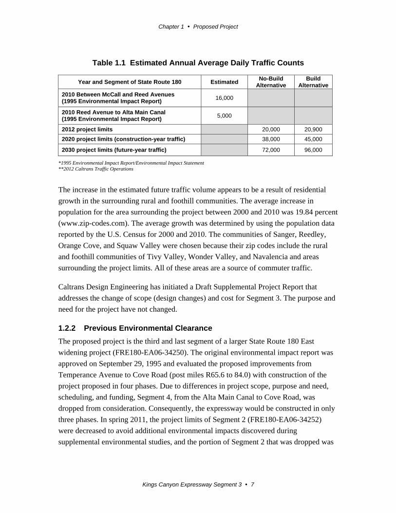
Table 1.1 provides the annual average daily traffic counts that the 1995 Environmental
Impact Report estimated for 2010 and the most recent traffic data for the project for 2012,
2020 and 2030.
Chapter 1 Proposed Project
Kings Canyon Expressway Segment 3 7
Table 1.1 Estimated Annual Average Daily Traffic Counts
Year and Segment of State Route 180 Estimated No-Build
Alternative Build
Alternative
2010 Between McCall and Reed Avenues (1995 Environmental Impact Report)
16,000
2010 Reed Avenue to Alta Main Canal (1995 Environmental Impact Report)
5,000
2012 project limits 20,000 20,900
2020 project limits (construction-year traffic) 38,000 45,000
2030 project limits (future-year traffic) 72,000 96,000
*1995 Environmental Impact Report/Environmental Impact Statement **2012 Caltrans Traffic Operations
The increase in the estimated future traffic volume appears to be a result of residential
growth in the surrounding rural and foothill communities. The average increase in
population for the area surrounding the project between 2000 and 2010 was 19.84 percent
(www.zip-codes.com). The average growth was determined by using the population data
reported by the U.S. Census for 2000 and 2010. The communities of Sanger, Reedley,
Orange Cove, and Squaw Valley were chosen because their zip codes include the rural
and foothill communities of Tivy Valley, Wonder Valley, and Navalencia and areas
surrounding the project limits. All of these areas are a source of commuter traffic.
Caltrans Design Engineering has initiated a Draft Supplemental Project Report that
addresses the change of scope (design changes) and cost for Segment 3. The purpose and
need for the project have not changed.
1.2.2 Previous Environmental Clearance
The proposed project is the third and last segment of a larger State Route 180 East
widening project (FRE180-EA06-34250). The original environmental impact report was
approved on September 29, 1995 and evaluated the proposed improvements from
Temperance Avenue to Cove Road (post miles R65.6 to 84.0) with construction of the
project proposed in four phases. Due to differences in project scope, purpose and need,
scheduling, and funding, Segment 4, from the Alta Main Canal to Cove Road, was
dropped from consideration. Consequently, the expressway would be constructed in only
three phases. In spring 2011, the project limits of Segment 2 (FRE180-EA06-34252)
were decreased to avoid additional environmental impacts discovered during
supplemental environmental studies, and the portion of Segment 2 that was dropped was
Chapter 1 Proposed Project
Kings Canyon Expressway Segment 3 8
added to Segment 3. Construction of Segment 1 was completed in fall 2011, and Segment
2 is currently being built.
A National Environmental Policy Act Reevaluation and California Environmental
Quality Act Addendum to File were approved for Segments 1 through 3 in June 2004.
These environmental documents primarily provided environmental clearance for right-of-
way acquisition and considered design changes related to intersections of the expressway
with local streets, Caltrans Highway Design Manual standards, a utility corridor, and
property access. The project description proposed constructing a four-lane expressway
from east of Temperance Avenue to east of Academy Avenue and a two-lane expressway
on a four-lane right-of-way from east of Academy Avenue to the Alta Main Canal.
A second National Environmental Policy Act Reevaluation and California Environmental
Quality Act Addendum to File were approved in December 2005. The 2005
environmental documents were necessary to update the previous Biological Assessment
submitted to the U.S. Fish and Wildlife Service. The project description in the 2005
Reevaluation was the same as the one in the 2004 National Environmental Policy Act
Reevaluation and all construction phases are documented in the 1994 Regional
Transportation Plan and the 1994 Federal Transportation Improvement Program.
Throughout the life of the project (including Segments 1-3), Caltrans biologists have
been consulting with representatives from the U.S. Fish and Wildlife Service, the
California Department of Fish and Wildlife, and the U.S. Army Corps of Engineers.
1.2.3 Changes in Project Setting and Circumstances
State Route 180 is the main east-west highway in eastern Fresno County, connecting the
Fresno-Clovis metropolitan area to Kings Canyon National Park and Sequoia National
Parks, as well as other rural recreational areas in the western Sierra Nevada Mountains.
The route passes through the unincorporated rural communities of Centerville and
Minkler and is important for moving agricultural goods from ranches and farms east of
Fresno. State Route 180 also serves the commuter traffic coming from the developed
foothill communities of Tivy Valley, Wonder Valley, and Squaw Valley, as well as the
many residential developments along the Kings River. State Route 180 provides one of
the main crossings of the Kings River in the county.
The project corridor remains as described in the 1995 Final Environmental Impact
Report. The existing alignment of State Route 180 crosses the floodplain of the Kings
River where the surrounding rural area is used mostly for grazing, with some low-density
Chapter 1 Proposed Project
Kings Canyon Expressway Segment 3 9
housing and small commercial operations. Exceptions are the small communities of
Centerville and Minkler, and a large sand/rock excavation company south of the existing
route on the west side of the Kings River. The existing State Route 180 crosses the Kings
River at a point where there are no other forks or tributaries (see Appendix C), and the
alignment of the 1995 Preferred Alternative remains the least environmentally damaging
practicable alternative (LEDPA). Caltrans has conducted ongoing environmental studies
for the project in recent years and has determined that crossing the Kings River in a
location farther north or south would result in an increase of impacts to biological
resources and residential/commercial developments.
1.2.4 Proposed Project Changes
Caltrans has made several design changes to the project relating to intersections of the
expressway with local streets, Caltrans design standards, utility corridors, and property
access. Changes in the design or scope of Segment 3 include the following:
Beginning at 0.7 mile west of Smith Avenue (post mile R74.1) to include a
portion of Segment 2 that was dropped for advanced project delivery.
Constructing a four-lane expressway instead of a two-lane limited access highway
on a four-lane right-of-way as stated in the 1995 Environmental Impact Report.
Constructing a 62-foot median as reported in the 2004 and 2005 Environmental
Reevaluations.
Acquiring a utility easement to consolidate the existing utilities along the north
side of the new alignment.
Acquiring Private Vehicle Access Easements (PVAE) for utility and private
access easements to keep properties from becoming “land-locked.”
Raising the profile (height) of the roadway at the Kings River, Cameron Slough,
and Byrd Slough to achieve a mandated 3-foot clearance between high water and
bottom of the bridge (also known as freeboard).
Removing a temporary intersection 0.7 mile west of Smith Avenue and a
temporary cul-de-sac 0.2 mile west of Smith Avenue constructed for Segment 2.
Adding left-turn lanes for northbound and southbound traffic at the intersections
of Piedra Road and Oliver, Rio Vista, Reed and Frankwood avenues.
Chapter 1 Proposed Project
Kings Canyon Expressway Segment 3 10
Realigning Oliver Avenue slightly to the east to avoid an eligible historic
building.
Adding frontage roads for access to the north side of State Route 180 west of
Oliver Avenue, west of Piedra Avenue, and east of Frankwood Avenue.
Eliminating the direct connection of Trimmer Springs Road to State Route 180
(Caltrans Highway Design Manual requirements for intersection spacing).
Realigning Trimmer Springs Road to connect to Oliver Avenue.
Constructing a bridge over China Slough instead of using a box culvert.
Adding a cul-de-sac to the existing State Route 180 east of Collins Creek.
Adding right-turn-only lanes with through bicycle lanes on eastbound State Route
180 at Rio Vista and Reed avenues.
Adding eastbound and westbound acceleration lanes at Rio Vista Avenue.
Adding a traffic signal at Reed Avenue.
Extending the box culverts at the Centerville-Kingsburg Canal and Collins Creek
for frontage roads and private vehicle access easements.
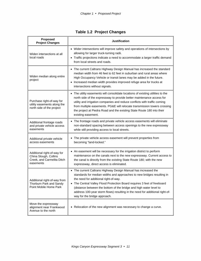
Some of these changes were included in the 2005 Environmental Reevaluation but, for
the convenience of the reader, those changes and the respective justifications have been
included in Table 1.2.
Chapter 1 Proposed Project
Kings Canyon Expressway Segment 3 11
Table 1.2 Project Changes
Proposed Project Changes
Justification
Widen intersections at all local roads
Wider intersections will improve safety and operations of intersections by
allowing for larger truck-turning radii.
Traffic projections indicate a need to accommodate a larger traffic demand
from local streets and roads.
Widen median along entire project
The current Caltrans Highway Design Manual has increased the standard
median width from 46 feet to 62 feet in suburban and rural areas where
High Occupancy Vehicle or transit lanes may be added in the future.
Increased median width provides improved refuge area for trucks at
intersections without signals.
Purchase right-of-way for utility easements along the north side of the project
The utility easements will consolidate locations of existing utilities to the
north side of the expressway to provide better maintenance access for
utility and irrigation companies and reduce conflicts with traffic coming
from multiple easements. PG&E will relocate transmission towers crossing
the project at Piedra Road and the existing State Route 180 into their
existing easement.
Additional frontage roads and private vehicle access easements
The frontage roads and private vehicle access easements will eliminate
non-standard spacing between access openings to the new expressway
while still providing access to local streets.
Additional private vehicle access easements
The private vehicle access easement will prevent properties from
becoming “land-locked.”
Additional right-of-way for China Slough, Collins Creek, and Carmelita Ditch easements
An easement will be necessary for the irrigation district to perform
maintenance on the canals next to the new expressway. Current access to
the canal is directly from the existing State Route 180; with the new
expressway, direct access is eliminated.
Additional right-of-way from Thorburn Park and Sandy Point Mobile Home Park
The current Caltrans Highway Design Manual has increased the
standards for median widths and approaches to new bridges resulting in
the need for additional right-of-way.
The Central Valley Flood Protection Board requires 3 feet of freeboard
(distance between the bottom of the bridge and high water level to
address 100-year storm flows) resulting in the need for additional right-of-
way for the bridge approach.
Move the expressway alignment near Frankwood Avenue to the north
Relocation of the new alignment was necessary to change a curve.
Chapter 1 Proposed Project
Kings Canyon Expressway Segment 3 12
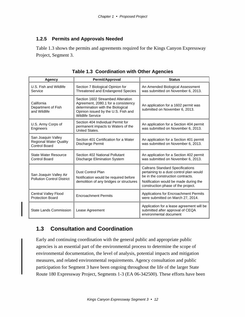
1.2.5 Permits and Approvals Needed
Table 1.3 shows the permits and agreements required for the Kings Canyon Expressway
Project, Segment 3.
Table 1.3 Coordination with Other Agencies
Agency Permit/Approval Status
U.S. Fish and Wildlife Service
Section 7 Biological Opinion for Threatened and Endangered Species
An Amended Biological Assessment was submitted on November 6, 2013.
California Department of Fish and Wildlife
Section 1602 Streambed Alteration Agreement, 2080.1 for a consistency determination with the Biological Opinion issued by the U.S. Fish and Wildlife Service
An application for a 1602 permit was submitted on November 6, 2013.
U.S. Army Corps of Engineers
Section 404 Individual Permit for permanent impacts to Waters of the United States.
An application for a Section 404 permit was submitted on November 6, 2013.
San Joaquin Valley Regional Water Quality Control Board
Section 401 Certification for a Water Discharge Permit
An application for a Section 401 permit was submitted on November 6, 2013.
State Water Resource Control Board
Section 402 National Pollutant Discharge Elimination System
An application for a Section 402 permit was submitted on November 6, 2013.
San Joaquin Valley Air Pollution Control District
Dust Control Plan
Notification would be required before demolition of any bridges or structures
Caltrans Standard Specifications pertaining to a dust control plan would be in the construction contracts.
Notification would be made during the construction phase of the project.
Central Valley Flood Protection Board
Encroachment Permits Applications for Encroachment Permits were submitted on March 27, 2014.
State Lands Commission Lease Agreement Application for a lease agreement will be submitted after approval of CEQA environmental document
1.3 Consultation and Coordination
Early and continuing coordination with the general public and appropriate public
agencies is an essential part of the environmental process to determine the scope of
environmental documentation, the level of analysis, potential impacts and mitigation
measures, and related environmental requirements. Agency consultation and public
participation for Segment 3 have been ongoing throughout the life of the larger State
Route 180 Expressway Project, Segments 1-3 (EA 06-342500). These efforts have been
Chapter 1 Proposed Project
Kings Canyon Expressway Segment 3 13
accomplished through a variety of formal and informal methods, including project
development team meetings and interagency coordination meetings.
Public Participation
Caltrans has held several open forum public information meetings for the Kings Canyon
Expressway Project, Segments 1-3. On May 24, 2001, an information meeting was held
in the town of Centerville at the local elementary school. About 170 people attended the
meeting. In March 2007, an open forum public information meeting was held to show the
proposed design changes to Segment 1 but also included the alignments of Segments 2
and 3. About 100 people attended the meeting held at Fancher Creek Elementary School
in east Fresno.
Two public advertisements of the availability of the Draft Supplemental Environmental
Impact Report with an Opportunity to Request a Public Meeting were published in the
Fresno Bee, and notices were mailed to federal, state, tribal, and local elected officials,
and to school officials in the rural areas of the county. Property owners, emergency
services, and public agencies in neighboring Sanger were notified by mail. One person
requested a public meeting but, after Caltrans staff discussed and addressed the
individual’s concerns, the request was withdrawn; so, no additional public meeting was
held.
Consultation
Consultation for Segment 3 has also been conducted with the following agencies, tribes,
and interested parties:
Consolidated Irrigation District
Kings River Water Association
Kings River Water District
Kings River Conservation District
Kings River Conservancy
Fresno County Parks and Recreation
Choinumi Tribe
Cal Fire
U.S. Army Corps of Engineers
U.S. Fish and Wildlife
California Department of Fish and Wildlife
Central Valley Flood Prevention Board
Chapter 1 Proposed Project
Kings Canyon Expressway Segment 3 14
California Department of Water Resources
California Native American Heritage Commission
California State Lands Commission
U.S. Environmental Protection Agency
Additional consultation with the U.S. Environmental Protection Agency about the project
resulted when, on November 6, 2013, Caltrans biologists submitted a Section 404
Nationwide Permit application to the U.S. Army Corps of Engineers for the project’s
permanent impacts to Waters of the United States. In response to the U.S. Army Corps of
Engineers’ request for comment, the U.S. Environmental Protection Agency submitted a
request to the Corps for more information on the project. Caltrans biologists’ submitted a
response to U.S. Army Corps of Engineers on March 7, 2014.
On July 23, 2014, the U.S. Environmental Protection Agency contacted the Caltrans
Environmental Division requesting a teleconference to discuss the project. On July 24,
2014, a teleconference was held with staff from Caltrans Environmental Division and the
U.S. Environmental Protection Agency. The discussion primarily concerned NEPA 404
Coordination and the increased impacts to Waters of the U.S. and wetlands because the
total impact had increased over 5.0 acres.
Caltrans submitted a NEPA 404 Coordination Report to the U.S. Army Corps of
Engineers for the larger project, State Route 180 Expressway Project, Segments 1-3 (EA
06-342500), on March 15, 1994. At that time, only five waterways were under the U.S.
Army Corps of Engineers’ jurisdiction within the project limits of Segment 3. The impact
to Waters of the U.S. was 2.32 acres, and the impact to the associated wetlands was 0.84
acre. Since 1995, the U.S. Army Corps of Engineers added five additional waterways
under their jurisdiction within the project limits of Segment 3, resulting in increasing the
associated wetland impact to 5.54 acres. Caltrans has decreased the impact to Waters of
the U.S. to 1.82 acre, and the increase in impact to wetlands can be attributed to:
Additional jurisdictional waterways and their associated wetlands
Highway design standards requiring a wider median
Private access, utility, and maintenance easements requiring frontage roads
Watering of permanent pastures creating artificial wetlands
The existing State Route 180 crosses the Kings River in a location where the forks of the
river merge together and there is one body of water to cross. Caltrans has conducted
ongoing environmental studies for the project in recent years and has determined that
crossing the Kings River in a location farther north or south would result in an increase of
Chapter 1 Proposed Project
Kings Canyon Expressway Segment 3 15
impacts to biological resources and residential and commercial properties. Therefore, the
1995 Preferred Alternative remains the least environmentally damaging practicable
alternative (LEDPA).
Notice of Preparation
On January 28, 2014, a Notice of Preparation (NOP) was filed for this project with the
State Clearinghouse. Responsible agencies must transmit their comments on the scope
and content of the Notice of Preparation, focusing on specific information related to their
statutory responsibility with 30 day of receipt of the Notice of Preparation from the lead
Agency (Caltrans). The following agencies responded to the Notice of Preparation:
February 4, 2014, the California State Lands Commission contacted the Project
Manager regarding a General Lease Agreement for its 0.56-acre parcel of land
along the Kings River. Previously, the commission gave Caltrans the right-of-way
to reconstruct the existing bridge over the Kings River. Caltrans has initiated an
application to amend Lease PRC 7533.9 for the construction of the new
westbound bridge over the Kings River.
March 12, 2014, the Fresno Yosemite International Airport submitted a letter
stating the project is not expected to result in any adverse impacts to the airport.
March 13, 2014, the U.S. Federal Emergency Management Agency (FEMA)
submitted a letter regarding floodplain management. Caltrans consulted the
jurisdictional waterway agencies during the development of the project and has
determined the project would not change the existing floodplain.
March 19, 2014, the Native American Heritage Commission submitted a letter of
recommendations for mitigation, consultation, and tribal contacts. The letter
submitted is similar to the letter included in Appendix D. It is Caltrans’ practice to
incorporate the recommendations made by the commission as much as possible.
March 19, 2014, the California Highway Patrol (CHP) sent an email stating safe
passage is one of the primary functions of its agency and it appears Caltrans and
the CHP share common goals. The CHP had no concerns to bring forth in regard
to traffic safety.
May 6, 2014, the San Joaquin Valley Air Pollution Control District submitted a
letter regarding potential impacts on air quality. It is Caltrans’ practice to
incorporate the regulations of the District into the construction contract.

Kings Canyon Expressway Segment 3 17
Chapter 2 Affected Environment, Environmental Consequences, and Avoidance, Minimization, and Mitigation Measures
This chapter explains impacts the project will have on the human, physical, and biological
environments in the project area. It describes the existing environment that can be affected by
the project, potential impacts of the alternatives, and proposed avoidance, minimization,
and/or mitigation measures. Any indirect impacts are also included in the general impacts
analysis and discussions.
As part of the environmental analysis conducted for the project, only new information or
substantial changes are discussed at length and only the avoidance, minimization and
mitigation measures for the project that have changed are included in the CEQA Checklist in
Appendix A. No further discussion is included in this document for any environmental issues
that did not change from the original conclusions of the 1995 Environmental Impact Report.
Therefore, the following environmental issues were considered, but no adverse impacts were
identified:
Land Use – The project is consistent with existing and future land use and with state,
regional, and local plans (Fresno County General Plan 2012, Regional Transportation Plan
2012, Federal Transportation Improvement Program 2012). The project would have an
effect on parks and recreational facilities, which is discussed in Section 2.1.1.1.
Coastal Zone – The project is not within a Coastal Zone, but is near the foothills of the Sierra
Nevada Mountain Range (Field survey 2013).
Wild and Scenic Rivers – No rivers classified as wild or scenic exist within the proposed
project area (Wild and Scenic Resources database, March 2012).
Growth – The findings of the 1995 Final Environmental Impact Report remain valid. The
proposed project eventually would help achieve planned residential development in the
project corridor, but would not accelerate planned growth or induce unplanned growth.
Farmlands and Timberlands – The project requires the purchase of approximately 155 acres
of farmland. Of that, 64 acres are considered Prime and Unique Farmland, and 51 acres
are considered Statewide and Local Important farmland (Natural Resources Conservation
Chapter 2 Affected Environment, Environmental Consequences, and Avoidance, Minimization and/or Mitigation Measures
Kings Canyon Expressway Segment 3 18
Services, Farmland Conversion Impact Rating, 2013). The impact rating total for Segment
3 was 155 points on the NRCS-CPA-106; therefore, the findings of the 1995 Final
Environmental Impact Report remain valid. No forest or tree stands are within the project
area (Field visit, March 2012).
Visual/Aesthetics – The findings of the 1995 Final Environmental Impact Report remain
valid. The proposed project would not have a negative effect on the overall rural character
of the landscape (Visual Impact Assessment, January 2014).
Cultural Resources – No archaeological or historical resources were identified within the
project area of Segment 3 based on surface identification efforts and geo-archaeology
efforts (Cultural Resources Memorandum, January 2014).
Hydrology and Floodplain – The findings of the 1995 Final Environmental Impact Report
and subsequent report remain valid (Email from D. Caldera, Caltrans Hydraulics, January
28, 2013). The floodplain designation on the Flood Insurance Rate Maps (FIRM) issued
by the Federal Emergency Management Agency (FEMA) was changed, but the changes
were minor and only in the wording of descriptions and did not change the design or scope
of the project (Addendum to the 1992 Location Hydraulic Study, April 2004).
Water Quality and Storm Water Runoff – Based on the water quality information and the
nature of the proposed project, no new impacts should occur when compared to the
original design (Re-Evaluation of the Water Quality Report for the State Route 180/Kings
Canyon Expressway Segment #3 in Fresno County, December 2012).
Geology/Soils/Seismic/Topography – No geologic or topographic features were identified
within the project area (National Registry of Natural Landmarks, Tulare County,
California, 2011). No active faults exist within the proposed project area (2010 Fault
Activity Map of California).
Paleontology – The geologic units associated with the project are categorized as “low”
sensitivity for paleontological resources. It is unlikely that paleontological resources will
be encountered because excavation will be within the upper few feet of soil (Updated
Paleontological Identification Report for Kings Canyon Expressway, Segment 3, Fresno
County, September 2011).
Hazardous Waste/Materials – The findings of the 1995 Final Environmental Impact Report
remain valid. A bridge survey on the Centerville-Kingsburg canal bridge on Smith Avenue
Chapter 2 Affected Environment, Environmental Consequences, and Avoidance, Minimization and/or Mitigation Measures
Kings Canyon Expressway Segment 3 19
(Bridge Number 42C-0043) would be completed prior to awarding the construction
contract to determine the appropriate Standard Special Provisions (Memorandum,
December 2013).
Air Quality – The findings of the 1995 Final Environmental Impact Report remain valid
(Environmental [Air Quality] Reevaluation for Kings Canyon Expressway Project
Segment 3, December 2012). Caltrans has determined the project is not a project of air
quality concern and will submit a complete request for a project-level conformity
determination from the Federal Highway Administration (FHWA) and Interagency
Consultation Partners prior to awarding the construction contract.
Noise – No sound abatement is recommended. The area of the proposed project was studied
in 2002 and revisited in 2012, and no new developments within the project limits were
identified. Therefore, the proposed changes to Segment 3 would not have new noise
impacts or result in any changes to the outcome of the noise study completed on
September 12, 2002 (Noise Study Reevaluation for the Kings Canyon Expressway
Segment #3, January 2013).
Energy – When balancing energy used during construction and operation against energy
saved by relieving congestion and other transportation efficiencies, the project would not
have substantial energy effects.
Invasive Species – In compliance with Executive Order 13112 pertaining to invasive species,
best management practices would be used to reduce the potential spread of noxious weeds
to or from the project site. This would include using clean dirt for fill, properly disposing
of soil from any excavated areas, and deploying proper erosion control techniques.
2.1 Human Environment
2.1.1 Land Use
2.1.1.1 Park and Recreation Facilities
Affected Environment
The public is provided access to areas along the Kings River, which is popular for fishing,
rafting, and canoeing. Several public and private recreational facilities sit near the project
area: Thorburn Park, Pierce’s Park campground, Whispering Waters Recreation Park, and a
Kampground of America (KOA).
Chapter 2 Affected Environment, Environmental Consequences, and Avoidance, Minimization and/or Mitigation Measures
Kings Canyon Expressway Segment 3 20
Thorburn Park – This public park is owned by Fresno County, but maintained and operated
by the Kings River Conservancy under an agreement and grant received from the California
Wildlife Conservation Board. During the process to obtain the California Wildlife
Conservation Board grant, an Inter-Governmental Review between Caltrans, Fresno County
and the Kings River Conservancy was conducted to establish a boundary for Thorburn Park
based on the preliminary right-of-way lines for the proposed highway project, including a
utility easement. Subsequently, a cyclone fence was built separating the proposed park from
the proposed right-of-way needed for the highway project.
The park is used mainly for river access and includes an unpaved access road, an unpaved
parking lot, an information kiosk, picnic tables, permanent vault toilets, and a trail
connecting the parking area to a boat launch. It is open year-round, but only on weekends
from September 2 through May 14. Its access gate is locked during non-operational hours.
This facility is north of the existing State Route 180, on the west side of the Kings River. The
public accesses the parking lot via Rio Vista Avenue on the west side of the property parcel.
Pierce’s Park Campground – This campground is privately owned and operated year-round.
Patrons pay for day use or overnight stays at this “dry” campground (the campground has no
water available for campers). The facility does not offer recreational vehicle facilities, and
access to the river is limited to its patrons. The facility is south of the existing State Route
180 on the west side of the Kings River. The public accesses the campground via the existing
State Route 180. Scott’s Canoe Rental is operated seasonally at this location and offers canoe
and tire tube rentals for use on the river when the water level allows it. A mobile home also
sits on this property.
Whispering Waters Recreation Park – This privately owned facility is operated seasonally
from March through November. The park contains two fishing ponds. Patrons pay admission
and for the fish they catch. There is no access to the river from this park, which sits south of
the existing State Route 180 on the east side of the Kings River. The public accesses the park
via the existing State Route 180.
Kampground of America – This facility offers tent camping, full recreational vehicle
hookups, a laundry and showers, WiFi, and a recreational room. The public accesses this
facility via a driveway that is shared with the Sandy Point Mobile Home Park off the existing
State Route 180 or via a dirt road from Piedra Road.
Chapter 2 Affected Environment, Environmental Consequences, and Avoidance, Minimization and/or Mitigation Measures
Kings Canyon Expressway Segment 3 21
Kings River – The Kings River offers the public fishing, rafting, and canoeing at this portion
of the river depending on how much water is released from Pine Flat Dam. At times, there is
not enough release of water to support watercrafts.
Environmental Consequences
Thorburn Park – The Highway Design Standards requiring wider medians and the
requirement for 3 feet of freeboard under the new bridge proposed at the Kings River have
resulted in design changes for the approach of the new bridge. The 3 feet of freeboard, the
distance between the bottom of the bridge and high water level to address 100-year storm
flows, is mandated by the Central Valley Flood Protection Board.
These new design requirements result in an additional sliver of right-of-way, approximately
20 feet wide or 0.1 acre, from the southern boundary of the park. Acquiring additional right-
of-way from the park will require moving the existing cyclone fence 20 feet to the north, a
permanent impact. The relocation of the cyclone fence will also result in moving the utility
easement to the north by 20 feet; this is a temporary easement that will not permanently
interfere with the intended use of Thorburn Park or its activities, features, and attributes.
During construction, access into this facility may be temporarily disrupted due to the
relocation of underground utilities.
Note: Under the National Environmental Policy Act (NEPA), this facility has been
determined a Section 4(f) resource as a publicly owned park under Section 4(f) of the
Department of Transportation Act of 1966, codified in federal law at 49 U.S.C. 303. Caltrans
has also determined the additional right-of-way is a de minimus impact, which, on impacts
on publicly owned parks, is defined as those that do not adversely affect the activities,
features, and attributes of the Section 4(f) resource. Section 4(f) and de minimus impacts are
not determinations made under the California Environmental Quality Act (CEQA) and,
therefore, not ordinarily mentioned in the California Environmental Quality Act (CEQA)
environmental document. However, these determinations are required public notification to
support the National Environmental Policy Act environmental revalidation of the 1995
Environmental Impact Study (EIS).
Pierce’s Park Campground – A sliver of property is needed from the north side of this
property parcel. As a result, the project would relocate the driveway from the north side to
the west side of the property parcel. An access road will be constructed from a proposed cul-
de-sac south of the new alignment of State Route 180 at Rio Vista Road. The project will
relocate the mobile home and its water and septic facilities. During construction, patrons may
Chapter 2 Affected Environment, Environmental Consequences, and Avoidance, Minimization and/or Mitigation Measures
Kings Canyon Expressway Segment 3 22
be temporarily unable to use certain portions of the campground and access into the
campground may be temporarily disrupted.
Whispering Waters Recreation Park – A sliver of right-of-way is needed from the northern
boundary of this property parcel requiring the relocation of the existing driveway. New
access into the park would be constructed on the south side of the property parcel on Lone
Oak Road via the new intersection of Piedra Road and the new alignment of State Route 180.
The project would relocate a breeding pond and move two fishing ponds to the south to
accommodate the new state right-of-way fence. In addition, a PG&E tower would be
relocated within PG&E’s easement, which crosses the park’s existing parking lot. During
construction, patrons may be temporarily unable to use certain portions of the park and
access into the park may be temporarily disrupted.
Kampground of America – No right-of-way is needed from this property parcel, but access
into this facility will be relocated to Piedra Road via a new frontage road. Patrons will access
Piedra Road via the new intersection of Piedra Road and the new alignment of State Route
180. During construction, no disruption is expected for this facility.
Kings River – The project will construct a new two-lane bridge over the Kings River north of
the existing bridge. During construction of the Kings River bridge, the public will not have
access to that location of the river for fishing, rafting or canoeing for safety reasons.
Avoidance, Minimization, and/or Mitigation Measures
Thorburn Park – The acquisition of additional right-of-way from the park cannot be avoided
due to the mandated design requirements. Any constructions activities will be coordinated
with the jurisdictional agency, Fresno County, to avoid interruption to park patrons.
Note: As required by the National Environmental Policy Act, Caltrans would comply with the
public review requirements for a Section 4(f) De Minimus finding on the project’s effect,
which requires concurrence from the responsible official with jurisdiction over the resource
after the public comment period.
Pierce’s Park Campground, Whispering Waters Recreation Park, and Kampground of
America – To minimize impacts during construction, any construction activities will be
coordinated with the respective park or campground to avoid disruptions for park patrons as
much as possible.
Chapter 2 Affected Environment, Environmental Consequences, and Avoidance, Minimization and/or Mitigation Measures
Kings Canyon Expressway Segment 3 23
Kings River – Construction of the bridge across the Kings River will be done during low
water levels as much as possible. Efforts to notify the public about temporary closure to
water activities at the river during construction will be made through local news releases and
public notification.
2.1.2 Community Impacts
2.1.2.1 Relocations and Real Property Acquisition
Affected Environment
The original environmental document reported that only 11 mobile homes would need
relocation. Based on field reviews conducted for the project from Temperance Avenue to the
Alta Main Canal, the Sandy Point Mobile Home Park has approximately 32 mobile homes.
The size, quality and condition of dwellings to be impacted by this project vary widely. Some
parcels are improved with quality dwellings, while others suffer from disrepair. Some of the
manufactured homes are substantial enough to be moved, while others will require
demolition, with the displacees relocated to another area.
In accordance with the Uniform Relocation Assistance and Real Property Acquisition
Policies Act of 1970, as amended, Caltrans will provide relocation advisory assistance to any
person, business, farm or nonprofit organization displaced as a result of the acquisition of
real property for public use.
Environmental Consequences
The Highway Design Standards requiring wider medians and 3 feet of freeboard under the
new bridge proposed at the Kings River have resulted in design changes for the approach of
the new bridge. The 3 feet of freeboard, the distance between the bottom of the bridge and
high water level to address 100-year storm flows, is mandated by the Central Valley Flood
Protection Board. These new design requirements result in additional right-of-way being
needed from the Sandy Point Mobile Home Park. This additional right-of-way will result in
the relocation of all of the mobile homes in the park (about 32 mobile homes). There is also a
potential for several single-family residences and mobile home relocations near the Byrd
Slough.
Avoidance, Minimization, and/or Mitigation Measures
Relocation of the Sandy Point Mobile Home Park cannot be avoided due to the mandated
design requirements for construction of the new bridge. Because the Kings River forks north
Chapter 2 Affected Environment, Environmental Consequences, and Avoidance, Minimization and/or Mitigation Measures
Kings Canyon Expressway Segment 3 24
and south of the existing State Route 180 bridge, any other location for a new bridge will
result in significant environmental impacts.
Adequate relocation resources for homeowners and renters exist within the local area (2013
Relocation Impact Document). All displacees will be contacted by a Relocation Agent, who
will ensure that eligible displacees receive their full relocation benefits, including advisory
assistance, and that all activities will be conducted in accordance with the Uniform
Relocation Assistance and Real Property Acquisition Policies Act of 1970, as amended.
Relocation resources will be available to all displacees free of discrimination. At the time of
the first written offer to purchase, owner occupants are given a detailed explanation of
Caltrans’ “Relocation Program and Services.” Soon after the first written offer to purchase,
tenant occupants of properties to be acquired are given a detailed explanation of Caltrans’
“Relocation Program and Services.”
2.1.3 Utilities and Emergency Services
Affected Environment
Utilities – PG&E currently owns a 30-foot-wide (approximately) easement that diagonally
crosses Piedra Road and the existing State Route 180 in a north-south direction east of the
Kings River. Two transmission towers are located within the realignment of Piedra Road and
the expressway. In addition, overhead utility lines and power poles that carry electrical power
lines, fiber-optic cable, and telephone lines are located throughout the proposed project area.
Emergency Services – Law enforcement is provided by the Fresno County Sheriff’s
Department, and fire suppression is provided by Cal Fire.
Environmental Consequences
Utilities – Caltrans would acquire a new utility easement next to the project to consolidate
utilities. In addition, near Piedra Road, the project requires the relocation of two PG&E
transmission towers within PG&E’s easement. One tower would be relocated within the state
right-of-way west of the new alignment of Piedra Road between the frontage road leading to
the Sandy Point Mobile Home Park and the expressway. The other tower would be relocated
to the southern portion of the Whispering Waters parking lot. The towers would have a base
of about 6 feet by 6 feet.
Emergency Services – Emergency response vehicles would have access via frontage roads.
Although direct access from the expressway has been eliminated (except for intersections),
Chapter 2 Affected Environment, Environmental Consequences, and Avoidance, Minimization and/or Mitigation Measures
Kings Canyon Expressway Segment 3 25
the additional travel lanes will provide a safer and speedier response time for emergency
services by avoiding the conflict with slower-moving vehicles and oncoming traffic.
Avoidance, Minimization, and/or Mitigation Measures
Utilities – Relocation of the towers cannot be avoided, and Caltrans has been consulting with
PG&E and other utilities to minimize the temporary disruption of services as much as
possible.
Emergency Services – A Traffic Management Plan will be developed to handle local traffic
patterns and reduce delays for emergency response vehicles during construction.
2.1.4 Traffic and Transportation/Pedestrian and Bicycle Facilities
Affected Environment
Traffic and Transportation – The existing State Route 180 is a two-lane conventional
highway with narrow or no shoulders and a speed limit of 55 miles per hour. Within the
project limits, the existing highway is intersected by a number of local roads controlled by
stop signs: Smith Avenue, Oliver Avenue, Trimmer Springs Road, Rio Vista Avenue, Piedra
Road, Lone Oak Road, Reed Avenue, and Frankwood Avenue (see Figure 1-2). These roads
are described below:
Smith Avenue – This small road has a bridge over the Centerville-Kingsburg Canal
and provides access to the existing State Route 180 from the north side of the canal.
Oliver Avenue – This road begins at Belmont Avenue to the north and crosses the
existing State Route 180 in Centerville before continuing into the city of Sanger and
the surrounding area.
Trimmer Springs Road – This segment of Trimmer Springs Road begins at Belmont
Avenue to the north and meanders along the river bottom before ending at the
existing State Route 180. Residents on the west side of the Kings River can use either
Trimmer Springs Road or Rio Vista Avenue for access to the existing State Route
180.
Rio Vista Avenue – This road intersects with Trimmer Springs Road and travels
along the west side of the Kings River before ending at the existing State Route 180.
Piedra Road – This road is a major connector to the foothill communities of Tivy
Valley and Wonder Valley, and to residents living on the east side of the Kings River.
Chapter 2 Affected Environment, Environmental Consequences, and Avoidance, Minimization and/or Mitigation Measures
Kings Canyon Expressway Segment 3 26
The road is also a connector to recreational areas along the east side of the Kings
River, such as Avocado Lake and Pine Flat Dam.
Lone Oak Road – This road currently intersects with the existing State Route 180 east
of Piedra Road and provides access to residents living along the east side of the Kings
River south of the existing highway.
Reed Avenue – This road ends at the existing State Route 180 and is a major
connector to the city of Reedley.
Frankwood Avenue – This road begins at Piedra Road near the Friant-Kern Canal
near the foothill community of Tivy Valley and is a north-south connector to the city
of Reedley. The Sherwood Golf Course and a large mobile home park sit along north
Frankwood Avenue.
Trimmer Springs Road, Rio Vista Lane, Piedra Road and Lone Oak Road intersect the
existing highway at a “skewed” angle that restricts a driver’s ability to see clearly to the right
and left; the driver must look nearly all the way behind him- or herself to see approaching
traffic. Drivers are also subject to marked pedestrian crossings and a reduced speed of 45
miles per hour in the community of Centerville. Drivers on the existing State Route 180 must
also be aware of the numerous driveways belonging to rural residents, farmers, ranchers, and
commercial businesses, as well as the recreational areas along the Kings River.
Pedestrian Facilities – The existing State Route 180 has no designated pedestrian facilities,
such as sidewalks or pedestrian walkways within the project limits. But within the
community of Centerville, pedestrian crosswalks are provided at Smith Avenue and Oliver
Avenue.
Bicycle Facilities – Currently, there are no designated Class One (bicycle paths) or Class
Three (bicycle routes) bicycle facilities within the proposed project limits. According to the
recently adopted Fresno County Regional Bicycle and Recreational Trails Master Plan
(September 24, 2013): “Approximately 86 miles of existing Class II bike lanes are generally
located in the eastern section of Fresno County east of Maple Avenue…along Belmont
Avenue to Trimmer Springs Road and then to the Friant-Kern Canal…” The Master Plan also
designates the rural portion of State Route 180 as a “Planned Bikeway” (except for segments
within Tulare County).
Chapter 2 Affected Environment, Environmental Consequences, and Avoidance, Minimization and/or Mitigation Measures
Kings Canyon Expressway Segment 3 27
Environmental Consequences
Traffic and Transportation – Removal of driveways and additional lanes are expected to
reduce accidents and conflicts between slower-moving vehicles and through traffic. The
divided highway or median is anticipated to reduce the number of head-on collisions, and the
wider shoulders (and shoulder backing) will provide a wider recovery zone for drivers
drifting off the travel lanes.
Change in traffic patterns will occur at almost all the local roads that intersect with the
existing State Route 180 (see Figure 1-2):
Smith Avenue – The bridge at Smith Road will be demolished, Smith Avenue will be
eliminated, and a frontage road (Ventura Avenue) will be constructed to provide
access to Oliver Avenue for residents living on the north side of the Centerville-
Kingsburg Canal (see Figure 1-2).
Oliver Avenue – A new intersection will be constructed north of the existing State
Route 180. North of the new intersection, Oliver Avenue will also intersect with a
new frontage road to the west (Ventura Avenue) and the realigned Trimmer Springs
Road to the east to provide access to local residents north of State Route 180.
Trimmer Springs Road – This road will be realigned to the west to intersect with
Oliver Avenue slightly north of the proposed intersection of the expressway and
Oliver Avenue.
Rio Vista Avenue – A new intersection will be constructed slightly to the east of the
existing intersection, removing the skewed angle and providing drivers with access to
the new expressway.
Piedra Road – A new intersection will be constructed to the west of the existing
intersection, removing the skewed angle and providing drivers with access to the new
expressway. This road will also have frontage roads to the east and west to provide
access to local residents.
Lone Oak Road – This road will remain in place. Residents could access the new
expressway via Piedra Road or go south to Reed Avenue. The existing intersection of
Lone Oak Road and the existing State Route 180 will remain, but the existing State
Route 180 will become a frontage road between Lone Oak Road and its new
intersection with the realignment of Reed Avenue.
Chapter 2 Affected Environment, Environmental Consequences, and Avoidance, Minimization and/or Mitigation Measures
Kings Canyon Expressway Segment 3 28
Reed Avenue – This road will be extended beyond the existing State Route 180 to the
northeast to intersect with the new expressway. It will be controlled by traffic signals.
Frankwood Avenue – The existing roadway will be realigned slightly before
intersecting with the new expressway. A frontage road will be constructed to the east
toward Alta Main Canal to provide access to residents living north of the expressway.
Portions of the existing State Route 180 will become a frontage road in the following areas
(west to east):
Within the community of Centerville, the existing State Route 180 will connect with
the newly constructed frontage road completed for Segment 2 east of the Centerville-
Kingsburg Canal and end with a cul-de-sac before crossing China Slough, east of
Trimmer Springs Road.
Between Collins Creek and Rio Vista Avenue, the existing State Route 180 will end
east of China Slough with a cul-de-sac.
Between Lone Oak Road and the new intersection with the realignment of Reed
Avenue, the existing State Route 180 connects Lone Oak Road to Reed Avenue.
Between Reed Avenue and Alta Main Canal, the existing T-intersection of State
Route 180 and Reed Avenue (at the fruit stand) will remain and the existing State
Route 180 will end east of Frankwood Avenue with a cul-de-sac.
Traffic delays are expected to be minimal because most of the new expressway will be built
on new alignments, avoiding any conflict with the existing traffic. The longest detour
expected during construction will be at Frankwood Avenue where drivers will be detoured 2
miles north to Piedra Road to access State Route 180. This detour is needed to avoid any
conflicts with construction equipment and should last about 3 weeks. Based on “test runs”
conducted in December 2013, this particular detour will result in increasing travel times for
commuters living on North Frankwood Avenue, or patrons of the Sherwood Golf Course, by
about 10 minutes.
Pedestrian Facilities – The pedestrian crosswalks on the existing State Route 180 in
Centerville will remain. Although no pedestrian crosswalks will be provided on the new State
Route 180 alignment, the project will provide wider shoulders for pedestrians. The proposed
side ditches will also provide an area for pedestrians away from traffic.
Chapter 2 Affected Environment, Environmental Consequences, and Avoidance, Minimization and/or Mitigation Measures
Kings Canyon Expressway Segment 3 29
Bicycle Facilities – Bike lanes will be provided at right-only turns, but no other bicycle
facilities on the expressway are proposed. The expressway will provide 10-foot paved
shoulders, which will be safer for bicyclists to use.
Avoidance, Minimization, and/or Mitigation Measures
Traffic and Transportation – A Traffic Management Plan will be developed to handle local
traffic patterns and reduce delays, congestion, and the likelihood of accidents during
construction. The Traffic Management Plan includes notifying the public of construction
activities via media outlets, using changeable message signs, using construction strategies,
and using the Central Valley Traffic Management Center, which reduces congestion by
monitoring traffic and informing the public via media outlets, such as radio and television.
Pedestrian and Bicycle Facilities – No mitigation is required.
2.2 Biological Environment
Caltrans completed a Re-evaluation Report for Segment 3 in March 2014. The biological
study area encompassed a 337-acre area containing agricultural fields, eight water crossings,
riparian areas, open fields, ranch-style homes, a mobile home park, and a few local
businesses. The topography of the area consists mostly of flat terrain ranging in elevation
from 385 feet to 400 feet above sea level.
Background research on sensitive species that could occur within the biological study area
was conducted using the California Natural Diversity Database, California Native Plant
Society on-line inventory, and U.S. Fish and Wildlife Service’s official species list for the
Sanger, Round Mountain, Piedra, and Wahtoke quadrangles.
References to the biological study area or the project limits or project (Segment 3) are not the
same. The biological study area is much larger than the project limits or the project, and it
takes into consideration the project limits and adjacent areas surrounding the project limits in
all directions. Reference to the project limits and the impacts resulting from Segment 3
include, but are not always limited to, the proposed right-of-way, utility easements, and
private vehicle access easements.
2.2.1 Natural Communities
This section of the document discusses natural communities of concern. The focus of this
section is on biological communities, not individual plant or animal species. This section also
includes information on wildlife corridors and habitat fragmentation. Wildlife corridors are
Chapter 2 Affected Environment, Environmental Consequences, and Avoidance, Minimization and/or Mitigation Measures
Kings Canyon Expressway Segment 3 30
areas of habitat used by wildlife for seasonal or daily migration. Habitat fragmentation
involves the potential for dividing sensitive habitat and thereby lessening its biological value.
Habitat areas that have been designated as critical habitat under the Federal Endangered
Species Act are discussed below in the Threatened and Endangered Species section, Section
2.2.5. Wetlands and other waters are discussed in Section 2.2.2.
Affected Environment
Valley Oak Woodland – The current Caltrans biological standard for identifying an “oak
woodland” is a 5-acre circular area containing five or more oak trees per acre (25 oak trees).
The 1995 Environmental Impact Report/Environmental Impact Study identified 94 valley
oak trees that were classified as riparian trees but did not identify oak woodland within the
study area.
Oak woodlands support great biological diversity and serve an important ecological function
by protecting soils from erosion and landslides, regulating water flow in watersheds, and
maintaining water quality in streams and rivers. In the 2000 Fresno County General Plan,
valley oaks are identified as significant tree resources due to their overall scarcity (Caltrans
Oak Woodlands Report, August 2014).
Caltrans biologists conducted several surveys in 2012 and 2013 and identified 49.21 acres of
valley oak woodland dominated by valley oaks. The valley oak woodland area contains 226
valley oaks plus 50 riparian trees that are not located within the riparian habitat identified in
the following discussion. Out of the 226 valley oaks and 50 riparian trees, 37 oaks and 26
riparian trees are considered heritage oaks. “Heritage” trees are classified as any tree with a
diameter at breast height equal to or greater than 24 inches.
Trees outside of the identified valley oak woodland include 67 oak trees, including 21 oak
trees considered heritage oaks.
Riparian Habitat – Riparian habitat exists next to waterways within the biological study area.
Dominant species observed within the identified riparian habitat include valley oak, western
sycamore (Platanus racemosa), black willow (Salix gooddingii), tail-leaf willow (Salix
lasiandra caudata), Oregon ash (Fraxinus latifolia), and Fremont cottonwood (Populus
fremontii).
The 2012/2013 surveys conducted by Caltrans biologists identified 33.28 acres of riparian
habitat. The area contained a total of 818 trees, 422 valley oak trees and 396 riparian trees,
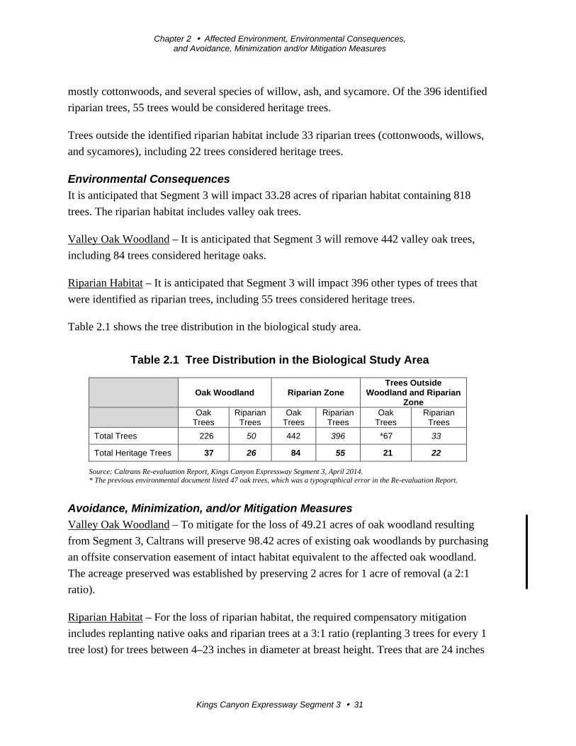
Chapter 2 Affected Environment, Environmental Consequences, and Avoidance, Minimization and/or Mitigation Measures
Kings Canyon Expressway Segment 3 31
mostly cottonwoods, and several species of willow, ash, and sycamore. Of the 396 identified
riparian trees, 55 trees would be considered heritage trees.
Trees outside the identified riparian habitat include 33 riparian trees (cottonwoods, willows,
and sycamores), including 22 trees considered heritage trees.
Environmental Consequences
It is anticipated that Segment 3 will impact 33.28 acres of riparian habitat containing 818
trees. The riparian habitat includes valley oak trees.
Valley Oak Woodland – It is anticipated that Segment 3 will remove 442 valley oak trees,
including 84 trees considered heritage oaks.
Riparian Habitat – It is anticipated that Segment 3 will impact 396 other types of trees that
were identified as riparian trees, including 55 trees considered heritage trees.
Table 2.1 shows the tree distribution in the biological study area.
Table 2.1 Tree Distribution in the Biological Study Area
Oak Woodland Riparian Zone
Trees Outside Woodland and Riparian
Zone
Oak Trees
Riparian Trees
Oak Trees
Riparian Trees
Oak Trees
Riparian Trees
Total Trees 226 50 442 396 *67 33
Total Heritage Trees 37 26 84 55 21 22
Source: Caltrans Re-evaluation Report, Kings Canyon Expressway Segment 3, April 2014. * The previous environmental document listed 47 oak trees, which was a typographical error in the Re-evaluation Report.
Avoidance, Minimization, and/or Mitigation Measures
Valley Oak Woodland – To mitigate for the loss of 49.21 acres of oak woodland resulting
from Segment 3, Caltrans will preserve 98.42 acres of existing oak woodlands by purchasing
an offsite conservation easement of intact habitat equivalent to the affected oak woodland.
The acreage preserved was established by preserving 2 acres for 1 acre of removal (a 2:1
ratio).
Riparian Habitat – For the loss of riparian habitat, the required compensatory mitigation
includes replanting native oaks and riparian trees at a 3:1 ratio (replanting 3 trees for every 1
tree lost) for trees between 4–23 inches in diameter at breast height. Trees that are 24 inches
Chapter 2 Affected Environment, Environmental Consequences, and Avoidance, Minimization and/or Mitigation Measures
Kings Canyon Expressway Segment 3 32
or more in diameter at breast height are defined as heritage trees and require replanting at a
10:1 ratio (replanting 10 trees for every 1 heritage tree lost).
Caltrans proposes to compensate for the loss of native trees at an offsite location within the
Kings River watershed, such as, Sequoia Riverlands Trust or El Rio Reyes Conservation
Trust. The final location depends on whether the facility can meet the mitigation needs.
2.2.2 Wetlands and Other Waters
Regulatory Setting
Wetlands and other waters are protected under a number of laws and regulations. At the
federal level, the Federal Water Pollution Control Act, more commonly referred to as the
Clean Water Act (33 U.S. Code 1344), is the main law regulating wetlands and surface
waters. One purpose of the Clean Water Act is to regulate the discharge of dredged or fill
material into Waters of the U.S., including wetlands. Waters of the U.S. include navigable
waters, interstate waters, territorial seas and other waters that may be used in interstate or
foreign commerce. To classify wetlands for the purposes of the Clean Water Act, we use a
three-parameter approach that includes the presence of: hydrophytic (water-loving)
vegetation, wetland hydrology, and hydric soils (soils formed during saturation/inundation).
All three parameters must be present, under normal circumstances, for an area to be
designated as a jurisdictional wetland under the Clean Water Act.
Section 404 of the Clean Water Act establishes a regulatory program that provides that
discharge of dredged or fill material cannot be permitted if a practicable alternative exists
that is less damaging to the aquatic environment or if the nation’s waters would be
significantly degraded. The Section 404 permit program is run by the U.S. Army Corps of
Engineers with oversight by the U.S. Environmental Protection Agency (U.S. EPA).
The U.S. Army Corps of Engineers issues two types of 404 permits: General and Standard
permits. There are two types of General permits: Regional permits and Nationwide permits.
Regional permits are issued for a general category of activities when they are similar in
nature and cause minimal environmental effect. Nationwide permits are issued to allow a
variety of minor project activities with no more than minimal effects.
Ordinarily, projects that do not meet the criteria for a Nationwide Permit may be permitted
under one of U.S. Army Corps of Engineers Standard permits. There are two types of
Standard permits: Individual permits and Letters of Permission. For Standard permits, the
U.S. Army Corps of Engineers’ decision to approve is based on compliance with the U.S.
Environmental Protection Agency’s Section 404(b)(1) Guidelines (U.S. EPA 40 Code of
Chapter 2 Affected Environment, Environmental Consequences, and Avoidance, Minimization and/or Mitigation Measures
Kings Canyon Expressway Segment 3 33
Federal Regulations Part 230), and whether permit approval is in the public interest. The 404
(b)(1) Guidelines were developed by the U.S. EPA in conjunction with the U.S. Army Corps
of Engineers, and allow the discharge of dredged or fill material into the aquatic system
(Waters of the U.S.) only if there is no practicable alternative that would have less adverse
effects. The guidelines state that the U.S. Army Corps of Engineers may not issue a permit if
there is a least environmentally damaging practicable alternative (LEDPA) to the proposed
discharge that would have lesser effects on waters of the U.S., and not have any other
significant adverse environmental consequences.
The executive order for the Protection of Wetlands (Executive Order 11990) also regulates
the activities of federal agencies with regard to wetlands. Essentially, this order states that a
federal agency, such as the Federal Highway Administration and/or Caltrans, as assigned,
cannot undertake or provide assistance for new construction located in wetlands unless the
head of the agency finds: 1) that there is no practicable alternative to the construction and 2)
the proposed project includes all practicable measures to minimize harm.
At the state level, wetlands and waters are regulated primarily by the State Water Resources
Control Board (SWRCB), the Regional Water Quality Control Board (RWQCB) and the
California Department of Fish and Wildlife. In certain circumstances, the Coastal
Commission (or Bay Conservation and Development Commission or the Tahoe Regional
Planning Agency) may also be involved. Sections 1600-1607 of the California Fish and
Game Code require any agency that proposes a project that will substantially divert or
obstruct the natural flow of or substantially change the bed or bank of a river, stream, or lake
to notify the California Department of Fish and Wildlife before beginning construction. If the
California Department of Fish and Wildlife determines that the project may substantially and
adversely affect fish or wildlife resources, a Lake or Streambed Alteration Agreement will be
required. California Department of Fish and Wildlife jurisdictional limits are usually defined
by the tops of the stream or lake banks, or the outer edge of riparian vegetation, whichever is
wider. Wetlands under jurisdiction of the U.S. Army Corps of Engineers may or may not be
included in the area covered by a Streambed Alteration Agreement obtained from the
California Department of Fish and Wildlife.
The Regional Water Quality Control Boards were established under the Porter-Cologne
Water Quality Control Act to oversee water quality. Discharges under the Porter-Cologne
Act are permitted by Waste Discharge Requirements (WDRs) and may be required even
when the discharge is already permitted or exempt under the Clean Water Act. In compliance
with Section 401 of the Clean Water Act, the Regional Water Quality Control Board also
Chapter 2 Affected Environment, Environmental Consequences, and Avoidance, Minimization and/or Mitigation Measures
Kings Canyon Expressway Segment 3 34
issues water quality certifications for activities that may result in a discharge to Waters of the
U.S. This is most frequently required in tandem with a Section 404 permit request.
Affected Environment
Caltrans biologists conducted wetland delineations for Segment 3 in the spring of 2011 and
spring of 2012, and in August 2014. In the fall of 2012, Caltrans contracted sub-consultants
to complete the wetland delineations, tree counts, and elderberry counts. Fieldwork
conducted by the sub-consultants was completed during the fall of 2012 and into January
2013. After submitting the Preliminary Jurisdictional determination to the U.S. Army Corps
of Engineers, the agency requested additional delineation, which was completed by Caltrans
biologists in July and August 2013, and in August 2014.
Construction of Segment 3 would require 8 water crossings (see Figure 1-2): the Centerville-
Kingsburg Canal, China Slough, Collins Creek, Kings River, Cameron Slough, Byrd Slough,
Carmelita Ditch, and Mount Campbell Ditch. Construction of the project ends before
crossing the Alta Main Canal and Friant-Kern Canal.
All of the identified waterways originate from the Kings River, which flows through Fresno
County and Kings County in a southwestern direction (see maps in Appendix C). The Kings
River is impounded by Pine Flat Dam in Piedra north of the project area.
Below Pine Flat Dam, the Alta Main Canal branches off of the Kings River and flows in a
southern direction into Wahtoke Lake, then flows into the Alta East Branch Canal and the
Reedley Main Canal both continuing to flow southeast. The Byrd Slough branches off of the
Alta Main Canal just north of Friant-Kern Canal, which crosses the Kings River about 10
miles west of Pine Flat Dam.
Just south of Friant-Kern Canal, the Kings River also flows into the Fresno Canal and the
Consolidated Canal. The Consolidated Canal then flows into the Fowler-Switch Canal and
the Centerville-Kingsburg Canal. Collins Creek branches off of the Centerville-Kingsburg
Canal, and China Slough branches off of Collins Creek. China Slough flows back into
Collins Creek, and then Collins Creek flows back into the Kings River.
Just north of the existing State Route 180, a tributary of Cameron Slough flows out of Byrd
Slough and just below the existing State Route 180, a tributary of Cameron Slough flows out
of the Kings River. Both Cameron Slough and Byrd Slough flow back into the Kings River.
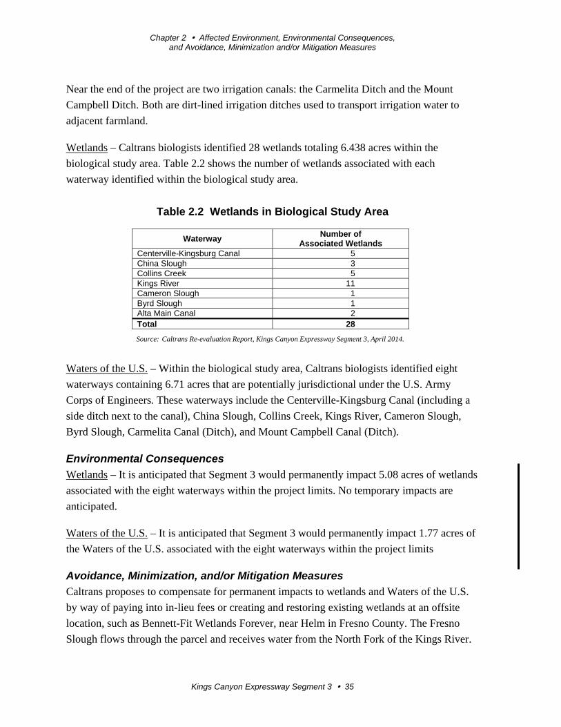
Chapter 2 Affected Environment, Environmental Consequences, and Avoidance, Minimization and/or Mitigation Measures
Kings Canyon Expressway Segment 3 35
Near the end of the project are two irrigation canals: the Carmelita Ditch and the Mount
Campbell Ditch. Both are dirt-lined irrigation ditches used to transport irrigation water to
adjacent farmland.
Wetlands – Caltrans biologists identified 28 wetlands totaling 6.438 acres within the
biological study area. Table 2.2 shows the number of wetlands associated with each
waterway identified within the biological study area.
Table 2.2 Wetlands in Biological Study Area
Waterway Number of
Associated Wetlands Centerville-Kingsburg Canal 5 China Slough 3 Collins Creek 5 Kings River 11 Cameron Slough 1 Byrd Slough 1 Alta Main Canal 2 Total 28
Source: Caltrans Re-evaluation Report, Kings Canyon Expressway Segment 3, April 2014.
Waters of the U.S. – Within the biological study area, Caltrans biologists identified eight
waterways containing 6.71 acres that are potentially jurisdictional under the U.S. Army
Corps of Engineers. These waterways include the Centerville-Kingsburg Canal (including a
side ditch next to the canal), China Slough, Collins Creek, Kings River, Cameron Slough,
Byrd Slough, Carmelita Canal (Ditch), and Mount Campbell Canal (Ditch).
Environmental Consequences
Wetlands – It is anticipated that Segment 3 would permanently impact 5.08 acres of wetlands
associated with the eight waterways within the project limits. No temporary impacts are
anticipated.
Waters of the U.S. – It is anticipated that Segment 3 would permanently impact 1.77 acres of
the Waters of the U.S. associated with the eight waterways within the project limits
Avoidance, Minimization, and/or Mitigation Measures
Caltrans proposes to compensate for permanent impacts to wetlands and Waters of the U.S.
by way of paying into in-lieu fees or creating and restoring existing wetlands at an offsite
location, such as Bennett-Fit Wetlands Forever, near Helm in Fresno County. The Fresno
Slough flows through the parcel and receives water from the North Fork of the Kings River.
Chapter 2 Affected Environment, Environmental Consequences, and Avoidance, Minimization and/or Mitigation Measures
Kings Canyon Expressway Segment 3 36
LEDPA Alternative Analysis – A corridor study was conducted for the project in 1990 to
identify alternative alignments that could minimize environmental impacts. The corridor
study area began at the eastern end of the future State Route 180 freeway/expressway near
the intersection of Fowler and Harvey Avenues in Fresno and extended east for about 9.4
miles to Cove Road (Segments 1-4). After the public hearing for the draft Environmental
Impact Report/Environmental Impact Statement, and based on community and agency input,
Alternative 1A was the preferred alternative selected for funding.
Supplemental environmental studies conducted for Segment 3 have determined that
Alternative 1A remains the least environmentally damaging practicable alternative (LEDPA).
An application for a Section 404 Nationwide Permit was submitted to the U.S. Army Corps
of Engineers on November 6, 2013.
2.2.3 Plant Species
The U.S. Fish and Wildlife Service and California Department of Fish and Wildlife have
regulatory responsibility for the protection of special-status plant species. “Special-status”
species are selected for protection because they are rare and/or subject to population and
habitat declines. “Special status” is a general term for species that are provided varying levels
of regulatory protection. The highest level of protection is given to threatened and
endangered species; these are species that are formally listed or proposed for listing as
endangered or threatened under the Federal Endangered Species Act (FESA) and/or the
California Endangered Species Act (CESA).
This section of the document discusses all the other special-status plant species, including
California Department of Fish and Wildlife species of special concern, U.S. Fish and
Wildlife Service candidate species, and California Native Plant Society rare and endangered
plants.
The regulatory requirements for the Federal Endangered Species Act can be found at 16 U.S.
Code Section 1531, et seq. See also 50 Code of Federal Regulations Part 402. The regulatory
requirements for the California Endangered Species Act can be found at California Fish and
Game Code, Section 2050, et seq. Department projects are also subject to the Native Plant
Protection Act, found at Fish and Game Code, Section 1900-1913, and the California
Environmental Quality Act, California Public Resources Code, Sections 2100-21177.
Affected Environment
Botanical surveys conducted in 2001/2002 for the Kings Canyon Expressway Project,
Segments 1-3, did not identify any special-status plant species. To update the botanical
Chapter 2 Affected Environment, Environmental Consequences, and Avoidance, Minimization and/or Mitigation Measures
Kings Canyon Expressway Segment 3 37
findings, Caltrans biologists conducted botanical surveys for Segment 3 in March 2014. The
following species were identified as having a potential to occur in the area:
Forked hare-leaf – The forked hare-leaf (Lagophylla dichotama) is on the California Native
Plant Society’s 1B list. It is an annual herb that is native to California and endemic (limited)
to California alone. It is a small genus of flowering plants in the Asteraceae family. This
plant has furry leaves and small yellow flowers that open up during the night (CNPS, 2014).
The California forked hare-leaf was not identified within the biological study area for
Segment 3 during the 2014 surveys.
San Joaquin adobe sunburst – The San Joaquin adobe sunburst is federally listed as
threatened, state listed as endangered, and on the California Native Plant Society’s 1B list. It
is an annual herb that is native to California and is part of the Asteraceae family (CNPS,
2014). This plant is 8 to 28 inches tall with triangular feather-shaped leaves with yellow
flowers. This species is typically found in grasslands within bare dark clay soils. The San
Joaquin adobe sunburst was not identified within the biological study area for Segment 3
during the 2014 surveys.
The California Natural Diversity Database documented an occurrence of this plant on the
east side of the Alta Main Canal in Porterville clay soil (the preferred soil for this species) at
the edge of the biological study area, and Porterville clay soil was identified within the
biological study area during the 2014 surveys near the end of the project limits.
Environmental Consequences
Forked hare-leaf – No impacts to the forked hare-leaf are anticipated as a result of the
proposed project.
San Joaquin adobe sunburst – No impacts to the San Joaquin adobe sunburst are anticipated
as a result of the proposed project. Although the San Joaquin adobe sunburst was not
identified during the 2014 botanical surveys, there is a potential for the plant to grow within
the biological study area because the preferred soil is present.
Avoidance, Minimization, and/or Mitigation Measures
California Native Plant Society-listed plants have the potential to occur within the project
area. Botanical surveys will be conducted in the blooming season before construction is
scheduled to begin to minimize potential impacts to any California Native Plant Society-
listed plants. If a California Native Plant Society-listed plant is found in the project area, 4
inches of topsoil from the area where the plant is found will be collected and stored until
Chapter 2 Affected Environment, Environmental Consequences, and Avoidance, Minimization and/or Mitigation Measures
Kings Canyon Expressway Segment 3 38
construction is complete. At that time, the topsoil will be restored to the temporarily
disturbed area.
With the above-mentioned avoidance and minimization measures, there will be no impacts to
the forked hare-leaf (Lagophylla dichotoma).
To minimize potential impacts for the federally listed San Joaquin adobe sunburst
(Pseudobahia Peirsonii), pre-construction surveys would be conducted in the appropriate
blooming period (March and April) prior to the beginning of construction activities.
2.2.4 Animal Species
Regulatory Setting
Many state and federal laws regulate impacts to wildlife. The U.S. Fish and Wildlife Service,
the National Oceanic and Atmospheric Administration’s National Marine Fisheries Service
(NOAA Fisheries Service) and the California Department of Fish and Wildlife are
responsible for implementing these laws. This section discusses potential impacts and permit
requirements associated with animals not listed or proposed for listing under the federal or
state Endangered Species Act. Species listed or proposed for listing as threatened or
endangered are discussed in Section 2.2.5 below. All other special-status animal species are
discussed here, including the California Department of Fish and Wildlife fully protected
species and species of special concern, and U.S. Fish and Wildlife Service or the National
Oceanic and Atmospheric Administration’s National Marine Fisheries Service candidate
species.
Federal laws and regulations relevant to wildlife include the following:
National Environmental Policy Act
Migratory Bird Treaty Act
Fish and Wildlife Coordination Act
State laws and regulations relevant to wildlife include the following:
California Environmental Quality Act
Sections 1600–1603 of the California Fish and Game Code
Sections 4150 and 4152 of the California Fish and Game Code
Chapter 2 Affected Environment, Environmental Consequences, and Avoidance, Minimization and/or Mitigation Measures
Kings Canyon Expressway Segment 3 39
Affected Environment
The tricolored blackbird is considered a California Species of Concern by the California
Department of Fish and Wildlife. This species is similar to the more common red-winged
blackbird, except for a prominent white stripe under the red wing patch, and more pointed
wings and bill. It is common locally throughout the Central Valley, breeding near freshwater,
preferably in emergent wetlands. Tricolored blackbirds usually nest in dense cattails, tules,
and thickets of willows, blackberry, wild rose, and tall forbs. Mud or plant material nests are
usually located a few feet over or near freshwater, or may be hidden on the ground among
low vegetations. The typical breeding season for tricolored blackbirds is mid-April to late
July.
The California Natural Diversity Database documented two occurrences of tricolored
blackbirds 5 miles north of the biological study area.
Environmental Consequences
No impacts to the tricolored blackbird are anticipated as a result of the proposed project.
Although the tricolored blackbird has not been documented within the project site by the
California Natural Diversity Database, there may be additional nesting habitat for this species
in valley freshwater marshes, riparian habitats, and foraging habitats within the biological
study area prior to construction.
Avoidance, Minimization, and/or Mitigation Measures
To minimize potential impacts to the tricolored blackbird, pre-construction surveys would be
conducted within the biological study area. In addition, a standard special provision for
migratory bird protection would be included in the construction contract and would minimize
impacts to the special-status species.
The Federal Migratory Bird Treaty Act protects most North American migratory birds, nests,
and eggs. It is preferable that tree removal occur outside of the nesting season (February 15-
September 1). If tree removal is not conducted during this time, a qualified biologist must
survey all trees and shrubs to be removed for active bird nests prior to the tree removal.
2.2.5 Threatened and Endangered Species
Regulatory Setting
The main federal law protecting threatened and endangered species is the Federal
Endangered Species Act (FESA): 16 U.S. Code Section 1531, et seq. See also 50 Code of
Federal Regulations Part 402. This act and later amendments provide for the conservation of
endangered and threatened species and the ecosystems upon which they depend.
Chapter 2 Affected Environment, Environmental Consequences, and Avoidance, Minimization and/or Mitigation Measures
Kings Canyon Expressway Segment 3 40
Under Section 7 of this act, federal agencies, such as the Federal Highway Administration are
required to consult with the U.S. Fish and Wildlife Service and the National Oceanic and
Atmospheric Administration’s National Marine Fisheries Service (NOAA Fisheries Service)
to ensure that they are not undertaking, funding, permitting, or authorizing actions likely to
jeopardize the continued existence of listed species or destroy or adversely modify
designated critical habitat. Critical habitat is defined as geographic locations critical to the
existence of a threatened or endangered species.
The outcome of consultation under Section 7 may include a Biological Opinion with an
Incidental Take statement, a Letter of Concurrence and/or documentation of a No Effect
finding. Section 3 of the Federal Endangered Species Act defines take as “harass, harm,
pursue, hunt, shoot, wound, kill, trap, capture or collect or any attempt at such conduct.”
California has enacted a similar law at the state level, the California Endangered Species Act
(CESA), California Fish and Game Code Section 2050, et seq. This act emphasizes early
consultation to avoid potential impacts to rare, endangered, and threatened species and to
develop appropriate planning to offset project-caused losses of listed species populations and
their essential habitats.
The California Department of Fish and Wildlife is the agency responsible for implementing
the California Endangered Species Act. Section 2081 of the Fish and Game Code prohibits
“take” of any species determined to be an endangered species or a threatened species. Take is
defined in Section 86 of the Fish and Game Code as “hunt, pursue, catch, capture, or kill, or
attempt to hunt, pursue, catch, capture, or kill.” The California Endangered Species Act
allows for take incidental to otherwise lawful development projects; for these actions, an
incidental take permit is issued by the California Department of Fish and Wildlife.
For species listed under both the Federal Endangered Species Act and the California
Endangered Species Act requiring a Biological Opinion under Section 7 of the Federal
Endangered Species Act, the California Department of Fish and Wildlife may also authorize
impacts to the California Endangered Species Act species by issuing a Consistency
Determination under Section 2080.1 of the Fish and Game Code.
Another federal law, the Magnuson-Stevens Fishery Conservation and Management Act of
1976, was established to conserve and manage fishery resources found off the coast, as well
as anadromous species and Continental Shelf fishery resources of the United States, by
exercising (A) sovereign rights for the purposes of exploring, exploiting, conserving, and
managing all fish within the exclusive economic zone established by Presidential
Chapter 2 Affected Environment, Environmental Consequences, and Avoidance, Minimization and/or Mitigation Measures
Kings Canyon Expressway Segment 3 41
Proclamation 5030, dated March 10, 1983, and (B) exclusive fishery management authority
beyond the exclusive economic zone over such anadromous species, Continental Shelf
fishery resources, and fishery resources in special areas.
Affected Environment
Vernal pool fairy shrimp – The vernal pool fairy shrimp (Branchinecta lynchi) is a federally
listed threatened species. The 1995 Environmental Impact Report/Environmental Impact
Statement determined the Kings Canyon Expressway Project, Segments 1-4, would have a
direct effect to seasonal pools and puddles potentially containing fairy shrimp along the
existing State Route 180. Although the fairy shrimp surveys conducted for the project at that
time determined the seasonal pools and puddles did not contain listed fairy shrimp, it was
also agreed that fairy shrimp may be present.
The vernal pool fairy shrimp is widespread throughout California, but there is only one
occurance recorded near the project site. The location is about 6 miles east of Centerville,
outside the project limits of Segment 3 near State Route 180 and Alta Road. This occurrence
is within the project limits of Segment 4 of the Kings Canyon Expressway Project, which
was dropped from further consideration.
Valley elderberry longhorn beetle – The valley elderberry longhorn beetle (Desmocerus
californicus dimorphus) is listed as a federally threatened species. This beetle is completely
dependent on the blue elderberry shrub (Sambuscus mexicana), a common component of
riparian forests of the Central Valley and associated foothills. The current distribution of the
species is patchy throughout the remaining riparian forests of the Central Valley from
Redding to Bakersfield.
Adults emerge from pupation inside the wood of elderberry shrubs in the spring as the
flowers begin to open. The exit holes made by the emerging adults are distinctive small oval
openings. Often these holes are the only clue that the beetles occur in an area. The adults eat
the elderberry foliage until mating season, about June. The females lay eggs in crevices in the
bark. Upon hatching, the larvae then begin to tunnel into the tree where they will spend 1-2
years eating the interior wood, which is their sole food source.
The 1995 Environmental Impact Report determined the project would not have any direct
impact to any elderberry shrubs growing along the existing highway, but proposed
transplanting any displaced elderberry at a ratio of 3 replantings to every 1 removal. The
2005 Reevaluation of the project identified only 73 elderberry shrubs within the original
study area, and the 2012/2013 surveys conducted by Caltrans biologists identified 134
Chapter 2 Affected Environment, Environmental Consequences, and Avoidance, Minimization and/or Mitigation Measures
Kings Canyon Expressway Segment 3 42
elderberry shrubs within the project limits. The addition of 59 shrubs could be attributed to
new growth of the species.
San Joaquin kit fox – The San Joaquin kit fox is federally listed as endangered and state
listed as threatened. It is the smallest candid species in North America and is mostly
nocturnal. The historic range of the San Joaquin kit fox included most of the San Joaquin
Valley from San Joaquin County southward to southern Kern County. Currently, kit foxes
occur in the remaining native valley floor and surrounding foothills from Kern County north
to Merced County. Distribution is spotty within this range.
The California Natural Diversity Database has documented two known occurrences of San
Joaquin kit foxes within the quadrangle maps that encompass the project site. One of the
occurrences is 1 mile south of State Route 180 in Sanger, and the second occurrence is 4.5
miles northeast of State Route 180. No San Joaquin kit foxes were identified within the
biological study area.
Swainson’s hawk – The Swainson’s hawk is listed as a state threatened species. The
Swainson’s hawk is a summer migrant in the Central Valley that breeds in riparian and oak
savannah habitat and forages in adjacent grasslands or suitable grain or alfalfa fields or
livestock pastures. Swainson’s hawks that breed in California typically spend winters in
Mexico and South America. In the Central Valley, over 85 percent of Swainson’s hawk
territories are in riparian systems that are next to suitable foraging habitat. In addition, the
hawks use lone trees or groves of trees in agricultural fields. Large trees and large willows
are most often used for nesting. Breeding occurs in March to late August, with peak activity
during late May through July.
The Swainson’s hawk was historically regarded as one of the most numerous raptors in the
state. The dramatic decline in the population of the Swainson’s hawk has been attributed to
the loss of native nesting and foraging habitat, and more recently to the loss of suitable
nesting trees. The loss of nesting habitat within riparian areas has been accelerated by flood
control practices and bank stabilization programs.
Environmental Consequences
Vernal pool fairy shrimp – In 2005, the U.S. Fish and Wildlife Service issued a Biological
Opinion requiring Caltrans to mitigate for the loss of 1.053 acres of fairy shrimp habitat.
However, because the habitat was of poor quality, the mitigation ratio was only 0.3 acre to 1
acre of impact (0.3:1 ratio).
Chapter 2 Affected Environment, Environmental Consequences, and Avoidance, Minimization and/or Mitigation Measures
Kings Canyon Expressway Segment 3 43
Valley elderberry longhorn beetle – The project would require the removal of approximately
104 elderberry shrubs within the project limits. However, in 2014, the U.S. Fish and Wildlife
Service approved surveys in the project area to determine whether the endangered species
was present. Pending the results of the tests, the U.S. Fish and Wildlife Service may
determine transplanting of these shrubs and/or mitigation is not required.
San Joaquin kit fox – No impacts to the San Joaquin kit fox are anticipated as a result of the
proposed project. Although no San Joaquin kit foxes were identified within the biological
study area, considering the distribution of the known occurrences and suitable foraging
habitats that are present throughout the biological study area, the San Joaquin kit fox could
den, forage, and disperse throughout the biological study area.
Swainson’s hawk – No impacts to the Swainson’s hawk are anticipated as a result of the
proposed project. Although the Swainson’s hawk has not been documented near the project
site by the California Natural Diversity Database, because of the existing potential nesting
habitat, a Swainson’s hawk could build a nest within the biological study area prior to
construction.
Avoidance, Minimization, and/or Mitigation Measures
Vernal pool fairy shrimp – No avoidance, minimization, or mitigation measures are proposed
for the vernal pool fairy shrimp for Segment 3. Caltrans mitigated impacts to 1.053 acres of
poor quality fairy shrimp habitat by purchasing 0.43 vernal pool conservation credits from
the Great Valley Conservation Bank in Rancho Cordova, California, which was approved by
the U.S. Fish and Wildlife Service for the entire Kings Canyon Expressway Project,
including Segment 3.
Valley elderberry longhorn beetle [if transplanting is required by U.S. Fish and Wildlife
Service] – The 104 elderberry shrubs that are within the project impact area would be
relocated to French Camp Conservation Bank. This facility is a U.S. Fish and Wildlife
Service-approved mitigation bank for the valley elderberry longhorn beetle. In addition, if
mitigation is required by the U.S. Fish and Wildlife Service, Caltrans will purchase
conservation credits at French Camp Conservation Bank.
Swainson’s hawk – The Federal Migratory Bird Treaty Act protects most North American
migratory birds, nests and eggs. It is preferable that tree removal occur outside of the nesting
season (February 15-September 1). If tree removal is not conducted during this time, a
qualified biologist must survey all trees and shrubs to be removed for active bird nests prior
to the tree removal.
Chapter 2 Affected Environment, Environmental Consequences, and Avoidance, Minimization and/or Mitigation Measures
Kings Canyon Expressway Segment 3 44
2.3 Climate Change
Climate change refers to long-term changes in temperature, precipitation, wind patterns, and
other elements of the earth’s climate system. An ever-increasing body of scientific research
attributes these climatological changes to greenhouse gas emissions, particularly those
generated from the production and use of fossil fuels.
While climate change has been a concern for several decades, the establishment of the
Intergovernmental Panel on Climate Change (IPCC) by the United Nations and World
Meteorological Organization in 1988 has led to increased efforts devoted to greenhouse gas
emissions reduction and climate change research and policy. These efforts are primarily
concerned with the emissions of greenhouse gases generated by human activity including
carbon dioxide (CO2), methane (CH4), nitrous oxide (N2O), tetrafluoromethane,
hexafluoroethane, sulfur hexafluoride (SF6), HFC-23 (fluoroform), HFC-134a (s, s, s, 2-
tetrafluoroethane), and HFC-152a (difluoroethane).
In the U.S., the main source of greenhouse gas emissions is electricity generation, followed
by transportation. In California, however, transportation sources (including passenger cars,
light-duty trucks, other trucks, buses, and motorcycles make up the largest source of
greenhouse gas-emitting sources. The dominant greenhouse gas emitted is carbon dioxide
(CO2), mostly from fossil fuel combustion.
There are typically two terms used when discussing the impacts of climate change:
“Greenhouse Gas Mitigation” and “Adaptation.” “Greenhouse Gas Mitigation” is a term for
reducing greenhouse gas emissions to reduce or “mitigate” the impacts of climate change.
“Adaptation” refers to the effort of planning for and adapting to impacts resulting from
climate change (such as adjusting transportation design standards to withstand more intense
storms and higher sea levels).1
There are four primary strategies for reducing greenhouse gas emissions from transportation
sources: 1) improving the transportation system and operational efficiencies, 2) reducing
travel activity, 3) transitioning to lower greenhouse gas-emitting fuels, and 4) improving
vehicle technologies/efficiency. To be most effective, all four strategies should be pursued
cooperatively.2
1 http://climatechange.transportation.org/ghg_mitigation/ 2 http://www.fhwa.dot.gov/environment/climate_change/mitigation/
Chapter 2 Affected Environment, Environmental Consequences, and Avoidance, Minimization and/or Mitigation Measures
Kings Canyon Expressway Segment 3 45
Regulatory Setting
This section outlines state and federal efforts to comprehensively reduce greenhouse
emissions from transportation sources.
State
With passage of several pieces of legislation including State Senate and Assembly Bills and
Executive Orders, California launched an innovative and proactive approach to dealing with
greenhouse gas emissions and climate.
Assembly Bill 1493 (AB 1493), Pavley, Vehicular Emissions: Greenhouse Gases, 2002: This
bill requires the California Air Resources Board (ARB) to develop and implement
regulations to reduce automobile and light truck greenhouse gas emissions. These stricter
emissions standards were designed to apply to automobiles and light trucks beginning with
the 2009-model year.
Executive Order (EO) S-3-05 (June 1, 2005): The goal of this order is to reduce California’s
greenhouse gas emissions to 1) year 2000 levels by 2010, 2) year 1990 levels by the 2020,
and 3) 80 percent below the year 1990 levels by 2050. In 2006, this goal was further
reinforced with the passage of Assembly Bill 32.
Assembly Bill 32 (AB 32), Núñez and Pavley, The Global Warming Solutions Act of 2006:
Assembly Bill 32 sets the same overall greenhouse gas emissions reduction goals as outlined
in Executive Order S-3-05, while further mandating that the California Air Resources Board
create a scoping plan and implement rules to achieve “real, quantifiable, cost-effective
reductions of greenhouse gases.”
Executive Order S-20-06 (October 18, 2006): This order establishes the responsibilities and
roles of the Secretary of the California Environmental Protection Agency (Cal EPA) and
state agencies with regard to climate change.
Executive Order S-01-07 (January 18, 2007): This order set forth the low carbon fuel
standard for California. Under this executive order, the carbon intensity of California’s
transportation fuels is to be reduced by at least 10 percent by 2020.
Senate Bill 97 (SB 97), Chapter 185, 2007, Greenhouse Gas Emissions: This bill required the
Governor’s Office of Planning and Research (OPR) to develop recommended amendments to
the California Environmental Quality Act (CEQA) Guidelines for addressing greenhouse gas
emissions. The amendments became effective on March 18, 2010.
Chapter 2 Affected Environment, Environmental Consequences, and Avoidance, Minimization and/or Mitigation Measures
Kings Canyon Expressway Segment 3 46
Senate Bill 375 (SB 375), Chapter 728, 2008, Sustainable Communities and Climate
Protection: This bill requires the California Air Resources Board (CARB) to set regional
emissions reduction targets from passenger vehicles. The Metropolitan Planning
Organization (MPO) for each region must then develop a “Sustainable Communities
Strategy” (SCS) that integrates transportation, land-use, and housing policies to plan for the
achievement of the emissions target for their region.
Senate Bill 391 (SB 391) Chapter 585, 2009 California Transportation Plan: This bill
requires the State’s long-range transportation plan to meet California’s climate change goals
under Assembly Bill 32.
Federal
Although climate change and greenhouse gas reduction are a concern at the federal level,
currently no regulations or legislation have been enacted specifically addressing greenhouse
gas emissions reductions and climate change at the project level. Neither the U.S.
Environmental Protection Agency (U.S. EPA) nor the Federal Highway Administration
(FHWA) has issued explicit guidance or methods to conduct project-level greenhouse gas
analysis.3
The Federal Highway Administration supports the approach that climate change
considerations should be integrated throughout the transportation decision-making process,
from planning through project development and delivery. Addressing climate change
mitigation and adaptation up front in the planning process will assist in decision-making and
improve efficiency at the program level, and will inform the analysis and stewardship needs
of project-level decision-making. Climate change considerations can be integrated into many
planning factors, such as supporting economic vitality and global efficiency, increasing
safety and mobility, enhancing the environment, promoting energy conservation, and
improving the quality of life.
The four strategies outlined by the Federal Highway Administration to lessen climate change
impacts correlate with efforts that the State is undertaking to deal with transportation and
climate change; these strategies include improved transportation system efficiency, cleaner
fuels, cleaner vehicles, and a reduction in travel activity.
3 To date, no national standards have been established regarding mobile source greenhouse gases, nor has U.S. EPA established any ambient standards, criteria or thresholds for greenhouse gases resulting from mobile sources.
Chapter 2 Affected Environment, Environmental Consequences, and Avoidance, Minimization and/or Mitigation Measures
Kings Canyon Expressway Segment 3 47
Climate change and its associated effects are being addressed through various efforts at the
federal level to improve fuel economy and energy efficiency, such as the “National Clean
Car Program” and Executive Order 13514 - Federal Leadership in Environmental, Energy
and Economic Performance.
Executive Order 13514 (October 5, 2009): This order is focused on reducing greenhouse
gases internally in federal agency missions, programs and operations, but also directs federal
agencies to participate in the Interagency Climate Change Adaptation Task Force, which is
engaged in developing a national strategy for adaptation to climate change.
The U.S. Environmental Protection Agency’s authority to regulate greenhouse gas emissions
stems from the U.S. Supreme Court decision in Massachusetts v. Environmental Protection
Agency (2007). The Supreme Court ruled that greenhouse gases meet the definition of air
pollutants under the existing Clean Air Act and must be regulated if these gases could be
reasonably anticipated to endanger public health or welfare. Responding to the Supreme
Court’s ruling, the U.S. Environmental Protection Agency finalized an endangerment finding
in December 2009. Based on scientific evidence, it found that six greenhouse gases constitute
a threat to public health and welfare. Thus, it is the Supreme Court’s interpretation of the
existing act and the Environmental Protection Agency’s assessment of the scientific evidence
that form the basis for the Environmental Protection Agency’s regulatory actions. The U.S.
Environmental Protection Agency in conjunction with the National Highway Traffic Safety
Administration (NHTSA) issued the first of a series of greenhouse emission standards for
new cars and light-duty vehicles in April 2010.4
The U.S. Environmental Protection Agency and the National Highway Traffic Safety
Administration are taking coordinated steps to enable the production of a new generation of
clean vehicles with reduced greenhouse gas emissions and improved fuel efficiency from on-
road vehicles and engines. These next steps include developing the first-ever greenhouse gas
regulations for heavy-duty engines and vehicles, as well as additional light-duty vehicle
greenhouse gas regulations.
The final combined standards that made up the first phase of this national program apply to
passenger cars, light-duty trucks, and medium-duty passenger vehicles, covering model years
2012 through 2016. The standards implemented by this program are expected to reduce
greenhouse gas emissions by an estimated 960 million metric tons and 1.8 billion barrels of
oil over the lifetime of the vehicles sold under the program (model years 2012-2016). 4 http://www.c2es.org/federal/executive/epa/greenhouse-gas-regulation-faq
Chapter 2 Affected Environment, Environmental Consequences, and Avoidance, Minimization and/or Mitigation Measures
Kings Canyon Expressway Segment 3 48
On August 28, 2012, the U.S. Environmental Protection Agency and the National Highway
Traffic Safety Administration issued a joint Final Rulemaking to extend the National
Program for fuel economy standards to model year 2017 through 2025 passenger vehicles.
Over the lifetime of the model year 2017-2025 standards, this program is projected to save
approximately four billion barrels of oil and two billion metric tons of greenhouse gas
emissions.
The complementary U.S. Environmental Protection Agency and National Highway Traffic
Safety Administration standards that make up the Heavy-Duty National Program apply to
combination tractors (semi trucks), heavy-duty pickup trucks and vans, and vocational
vehicles (including buses and refuse or utility trucks). Together, these standards will cut
greenhouse gas emissions and domestic oil use significantly. This program responds to
President Barack Obama’s 2010 request to jointly establish greenhouse gas emissions and
fuel efficiency standards for the medium- and heavy-duty highway vehicle sector. The
agencies estimate that the combined standards will reduce carbon dioxide (CO2) emissions by
about 270 million metric tons and save about 530 million barrels of oil over the life of model
year 2014 to 2018 heavy-duty vehicles.
Project Analysis
An individual project does not generate enough greenhouse gas emissions to significantly
influence global climate change. Rather, global climate change is a cumulative impact. This
means that a project may contribute to a potential impact through its incremental change in
emissions when combined with the contributions of all other sources of greenhouse gas.5 In
assessing cumulative impacts, it must be determined if a project’s incremental effect is
“cumulatively considerable” (California Environmental Quality Act Guidelines Sections
15064(h)(1) and 15130). To make this determination, we must compare the incremental
impacts of the project with the effects of past, current, and probable future projects.
Gathering sufficient information on a global scale of all past, current, and future projects to
make this determination is a difficult, if not impossible, task.
The Assembly Bill 32 Scoping Plan mandated by Assembly Bill 32 includes the main
strategies California will use to reduce greenhouse gas emissions. As part of its supporting
documentation for the Draft Scoping Plan, the California Air Resources Board released the 5 This approach is supported by the AEP: Recommendations by the Association of Environmental Professionals on How to Analyze GHG Emissions and Global Climate Change in CEQA Documents (March 5, 2007), as well as the South Coast Air Quality Management District (Chapter 6: The CEQA Guide, April 2011) and the US Forest Service (Climate Change Considerations in Project Level NEPA Analysis, July 13, 2009).
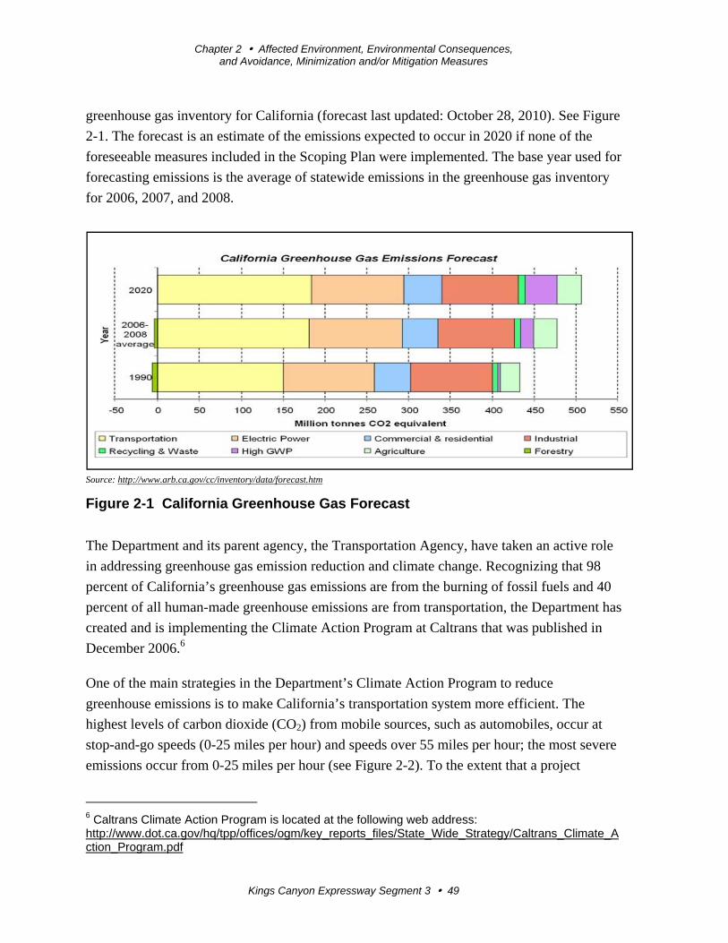
Chapter 2 Affected Environment, Environmental Consequences, and Avoidance, Minimization and/or Mitigation Measures
Kings Canyon Expressway Segment 3 49
greenhouse gas inventory for California (forecast last updated: October 28, 2010). See Figure
2-1. The forecast is an estimate of the emissions expected to occur in 2020 if none of the
foreseeable measures included in the Scoping Plan were implemented. The base year used for
forecasting emissions is the average of statewide emissions in the greenhouse gas inventory
for 2006, 2007, and 2008.
Source: http://www.arb.ca.gov/cc/inventory/data/forecast.htm
Figure 2-1 California Greenhouse Gas Forecast
The Department and its parent agency, the Transportation Agency, have taken an active role
in addressing greenhouse gas emission reduction and climate change. Recognizing that 98
percent of California’s greenhouse gas emissions are from the burning of fossil fuels and 40
percent of all human-made greenhouse emissions are from transportation, the Department has
created and is implementing the Climate Action Program at Caltrans that was published in
December 2006.6
One of the main strategies in the Department’s Climate Action Program to reduce
greenhouse emissions is to make California’s transportation system more efficient. The
highest levels of carbon dioxide (CO2) from mobile sources, such as automobiles, occur at
stop-and-go speeds (0-25 miles per hour) and speeds over 55 miles per hour; the most severe
emissions occur from 0-25 miles per hour (see Figure 2-2). To the extent that a project
6 Caltrans Climate Action Program is located at the following web address: http://www.dot.ca.gov/hq/tpp/offices/ogm/key_reports_files/State_Wide_Strategy/Caltrans_Climate_Action_Program.pdf
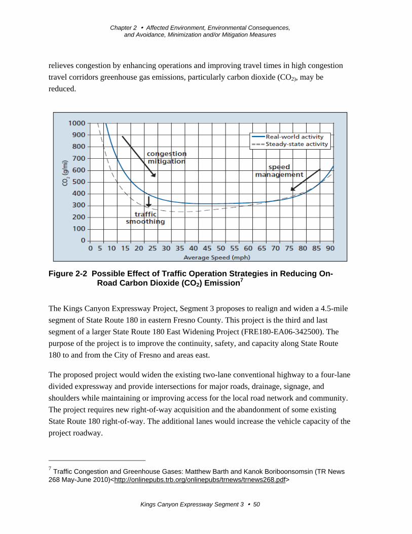
Chapter 2 Affected Environment, Environmental Consequences, and Avoidance, Minimization and/or Mitigation Measures
Kings Canyon Expressway Segment 3 50
relieves congestion by enhancing operations and improving travel times in high congestion
travel corridors greenhouse gas emissions, particularly carbon dioxide (CO2), may be
reduced.
Figure 2-2 Possible Effect of Traffic Operation Strategies in Reducing On-Road Carbon Dioxide (CO2) Emission7
The Kings Canyon Expressway Project, Segment 3 proposes to realign and widen a 4.5-mile
segment of State Route 180 in eastern Fresno County. This project is the third and last
segment of a larger State Route 180 East Widening Project (FRE180-EA06-342500). The
purpose of the project is to improve the continuity, safety, and capacity along State Route
180 to and from the City of Fresno and areas east.
The proposed project would widen the existing two-lane conventional highway to a four-lane
divided expressway and provide intersections for major roads, drainage, signage, and
shoulders while maintaining or improving access for the local road network and community.
The project requires new right-of-way acquisition and the abandonment of some existing
State Route 180 right-of-way. The additional lanes would increase the vehicle capacity of the
project roadway.
7 Traffic Congestion and Greenhouse Gases: Matthew Barth and Kanok Boriboonsomsin (TR News 268 May-June 2010)<http://onlinepubs.trb.org/onlinepubs/trnews/trnews268.pdf>
Chapter 2 Affected Environment, Environmental Consequences, and Avoidance, Minimization and/or Mitigation Measures
Kings Canyon Expressway Segment 3 51
The Fresno Council of Governments (Fresno COG) is the designated Metropolitan Planning
Organization (MPO) in Fresno County, California, and is responsible for regional
transportation planning. Fresno Council of Governments has a 2014 Sustainable
Communities Strategy (SCS) document in conjunction with the regional plan. Sustainable
Communities Strategy plans consider long-term housing, transportation and land use needs
by envisioning how to use resources efficiently, protect existing communities, conserve
farmland and open space, and support the economy while growing over time.
The State Route 180 Improvement Project Final Environmental Impact Report (1995)
evaluated transportation system management (TSM) as a method to increase the efficiency of
moving people over the existing roadway. The objective of transportation system
management is to increase the capacity of the existing transportation facility with minimal
expenditures by such means as restriping the roadway to add lanes, providing left- and right-
turn lanes to minimize disruption of through traffic, providing park-and-ride lots to facilitate
carpooling, instituting employer trip reduction programs, and synchronizing traffic signals to
improve circulation. However, the existing lane and shoulder widths were not to Caltrans
standard and it was not possible to restripe the existing roadway to add lanes. Providing left-
turn lanes would not result in accommodating additional traffic capacity because the two-lane
conventional highway was largely dependent on the ability for motorists to pass. Providing
park-and-ride lots are best suited to major transportation corridors such as State Route 180
and one was constructed in Segment 2 at McCall Avenue. An additional park-and-ride was
not proposed for Segment 3 because it would not necessarily reduce traffic demand.
The State Route 180 Improvement Project Final Environmental Impact Report (1995) also
evaluated mass transit such as bus and light rail transit for the project but determined that,
based on existing and future land use plans for the project area, residential densities would
not support either one.
Quantitative Analysis
The project would relieve traffic congestion and improve traffic flow by providing two
additional travel lanes for State Route 180. As shown in Figure 2-2, vehicles tend to operate
less efficiently at low speeds and very high speeds. However, the highway surface
smoothness and highway’s level of service would be improved if the project is built,
contributing to increased vehicle efficiency through reducing congestion and decreasing
rolling resistance.
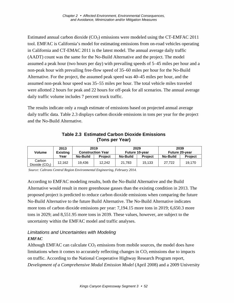
Chapter 2 Affected Environment, Environmental Consequences, and Avoidance, Minimization and/or Mitigation Measures
Kings Canyon Expressway Segment 3 52
Estimated annual carbon dioxide (CO2) emissions were modeled using the CT-EMFAC 2011
tool. EMFAC is California’s model for estimating emissions from on-road vehicles operating
in California and CT-EMAC 2011 is the latest model. The annual average daily traffic
(AADT) count was the same for the No-Build Alternative and the project. The model
assumed a peak hour (two hours per day) with prevailing speeds of 5–45 miles per hour and a
non-peak hour with prevailing free-flow speed of 35–60 miles per hour for the No-Build
Alternative. For the project, the assumed peak speed was 40–45 miles per hour, and the
assumed non-peak hour speed was 35–55 miles per hour. The total vehicle miles traveled
were allotted 2 hours for peak and 22 hours for off-peak for all scenarios. The annual average
daily traffic volume includes 7 percent truck traffic.
The results indicate only a rough estimate of emissions based on projected annual average
daily traffic data. Table 2.3 displays carbon dioxide emissions in tons per year for the project
and the No-Build Alternative.
Table 2.3 Estimated Carbon Dioxide Emissions (Tons per Year)
Volume 2013
Existing Year
2019Construction Year
2029Future 10-year
2039 Future 20-year
No-Build Project No-Build Project No-Build ProjectCarbon
Dioxide (CO2) 12,162 19,436 12,242 21,783 15,133 27,722 19,170
Source: Caltrans Central Region Environmental Engineering, February 2014.
According to EMFAC modeling results, both the No-Build Alternative and the Build
Alternative would result in more greenhouse gasses than the existing condition in 2013. The
proposed project is predicted to reduce carbon dioxide emissions when comparing the future
No-Build Alternative to the future Build Alternative. The No-Build Alternative indicates
more tons of carbon dioxide emissions per year: 7,194.15 more tons in 2019; 6,650.3 more
tons in 2029; and 8,551.95 more tons in 2039. These values, however, are subject to the
uncertainty within the EMFAC model and traffic analyses.
Limitations and Uncertainties with Modeling EMFAC
Although EMFAC can calculate CO2 emissions from mobile sources, the model does have
limitations when it comes to accurately reflecting changes in CO2 emissions due to impacts
on traffic. According to the National Cooperative Highway Research Program report,
Development of a Comprehensive Modal Emission Model (April 2008) and a 2009 University
Chapter 2 Affected Environment, Environmental Consequences, and Avoidance, Minimization and/or Mitigation Measures
Kings Canyon Expressway Segment 3 53
of California study,8 brief but rapid accelerations, such as those occurring during congestion,
can contribute significantly to a vehicle’s CO2 emissions during a typical urban trip. Current
emission-factor models are insensitive to the distribution of such modal events (i.e., cruise,
acceleration, deceleration, and idling) in the operation of a vehicle and instead estimate
emissions by average trip speed. This limitation creates an uncertainty in the model’s results
when compared to the estimated emissions of the various alternatives with the baseline in an
attempt to determine impacts. Although work by the EPA and the California Air Resources
Board is underway on modal-emission models, neither agency has yet approved a modal
emissions model that can be used to conduct this more accurate modeling.
The California Air Resources Board is currently not using EMFAC to create its inventory of
greenhouse gas emissions. It is unclear why the California Air Resources Board has made
this decision. Its website states only this:
REVISION: Both the EMFAC and OFFROAD Models develop CO2 and C4
(methane) emission estimates; however, they are not currently used as the basis for
(CARB’s) official (greenhouse gas) inventory which is based on fuel usage
information. . . However, ARB is working towards reconciling the emission estimates
from the fuel usage approach and the models.9
Other Variables
With the current science, project-level analysis of greenhouse gas emissions has limitations.
Although a greenhouse gas analysis is included for this project, there are numerous key
greenhouse gas variables that are likely to change dramatically during the design life of the
proposed project and would thus dramatically change the projected CO2 emissions.
First, vehicle fuel economy is increasing. The EPA’s annual report, “Light-Duty Automotive
Technology and Fuel Economy Trends: 1975 through 2012 ,”10 which provides data on the
fuel economy and technology characteristics of new light-duty vehicles including cars,
minivans, sport utility vehicles, and pickup trucks, confirms that average fuel economy has
improved each year beginning in 2005, and is now at a record high. Corporate Average Fuel
Economy (CAFE) standards remained the same between model years 1995 and 2003 and
subsequently began setting increasingly higher fuel economy standards for future vehicle
8 Matthew Bartha, Kanok Boriboonsomsin. 2009. Energy and emissions impacts of a freeway-based dynamic eco-driving system. Transportation Research Part D: Transport and Environment
Volume 14, Issue 6, August 2009, Pages 400–410 9 http://www.arb.ca.gov/msei/offroad.htm 10 http://www.epa.gov/oms/fetrends.htm
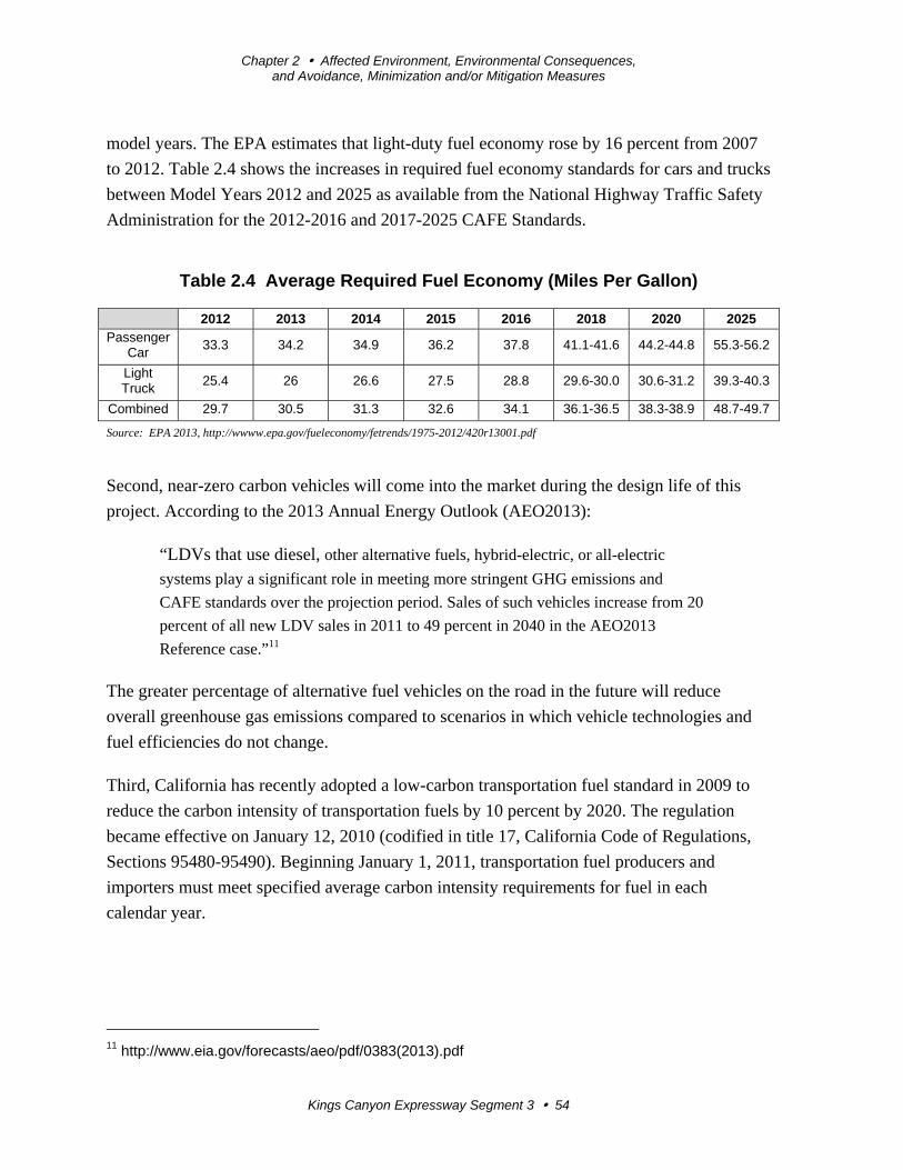
Chapter 2 Affected Environment, Environmental Consequences, and Avoidance, Minimization and/or Mitigation Measures
Kings Canyon Expressway Segment 3 54
model years. The EPA estimates that light-duty fuel economy rose by 16 percent from 2007
to 2012. Table 2.4 shows the increases in required fuel economy standards for cars and trucks
between Model Years 2012 and 2025 as available from the National Highway Traffic Safety
Administration for the 2012-2016 and 2017-2025 CAFE Standards.
Table 2.4 Average Required Fuel Economy (Miles Per Gallon)
2012 2013 2014 2015 2016 2018 2020 2025 Passenger
Car 33.3 34.2 34.9 36.2 37.8 41.1-41.6 44.2-44.8 55.3-56.2
Light Truck
25.4 26 26.6 27.5 28.8 29.6-30.0 30.6-31.2 39.3-40.3
Combined 29.7 30.5 31.3 32.6 34.1 36.1-36.5 38.3-38.9 48.7-49.7
Source: EPA 2013, http://wwww.epa.gov/fueleconomy/fetrends/1975-2012/420r13001.pdf
Second, near-zero carbon vehicles will come into the market during the design life of this
project. According to the 2013 Annual Energy Outlook (AEO2013):
“LDVs that use diesel, other alternative fuels, hybrid-electric, or all-electric
systems play a significant role in meeting more stringent GHG emissions and
CAFE standards over the projection period. Sales of such vehicles increase from 20
percent of all new LDV sales in 2011 to 49 percent in 2040 in the AEO2013
Reference case.”11
The greater percentage of alternative fuel vehicles on the road in the future will reduce
overall greenhouse gas emissions compared to scenarios in which vehicle technologies and
fuel efficiencies do not change.
Third, California has recently adopted a low-carbon transportation fuel standard in 2009 to
reduce the carbon intensity of transportation fuels by 10 percent by 2020. The regulation
became effective on January 12, 2010 (codified in title 17, California Code of Regulations,
Sections 95480-95490). Beginning January 1, 2011, transportation fuel producers and
importers must meet specified average carbon intensity requirements for fuel in each
calendar year.
11 http://www.eia.gov/forecasts/aeo/pdf/0383(2013).pdf
Chapter 2 Affected Environment, Environmental Consequences, and Avoidance, Minimization and/or Mitigation Measures
Kings Canyon Expressway Segment 3 55
Lastly, driver behavior has been changing as the U.S. economy and oil prices have changed.
In its January 2008 report, “Effects of Gasoline Prices on Driving Behavior and Vehicle
Market,”12 the Congressional Budget Office found the following results based on data
collected from California: 1) freeway motorists adjust to higher gas prices by making fewer
trips and driving more slowly; 2) the market share of sports utility vehicles is declining; and
3) the average prices for larger, less-fuel-efficient models declined from 2003 to 2008 as
average prices for the most-fuel-efficient automobiles have risen, showing an increase in
demand for the more fuel-efficient vehicles.
More recent reports from the Energy Information Agency13 and Bureau of Economic
Analysis14 also show slowing re-growth of vehicle sales in the years since its dramatic drop
in 2009 due to the Great Recession as gasoline prices continue to climb to $4 per gallon and
beyond.
Limitations and Uncertainties with Impact Assessment
Taken from pages 5-22 of the National Highway Traffic Safety Administration Final EIS for
MY2017-2025 CAFE Standards (July 2012), Figure 2-3 illustrates how the range of
uncertainties in assessing greenhouse gas impacts grows with each step of the analysis:
“Moss and Schneider (2000) characterize the ‘cascade of uncertainty’ in climate change
simulations Figure 2-3. As indicated in Figure 2-3, the emission estimates used in this EIS
have narrower bands of uncertainty than the global climate effects, which are less uncertain
than regional climate change effects. The effects on climate are, in turn, less uncertain than
the impacts of climate change on affected resources (such as terrestrial and coastal
ecosystems, human health, and other resources […] Although the uncertainty bands broaden
with each successive step in the analytic chain, all values within the bands are not equally
likely; the mid‐range values have the highest likelihood.”15
12 http://www.cbo.gov/ftpdocs/88xx/doc8893/01-14-GasolinePrices.pdf 13http://www.eia.gov/oiaf/aeo/tablebrowser/aeo_query_server/?event=ehExcel.getFile&study=AEO2013®ion=0-0&cases=ref2013-d102312a&table=114-AEO2013&yearFilter=0 14 Historical Vehicle Sales: www.bea.gov/national/xls/gap_hist.xls 15 http://www.nhtsa.gov/staticfiles/rulemaking/pdf/cafe/FINAL_EIS.pdf. page 5-22
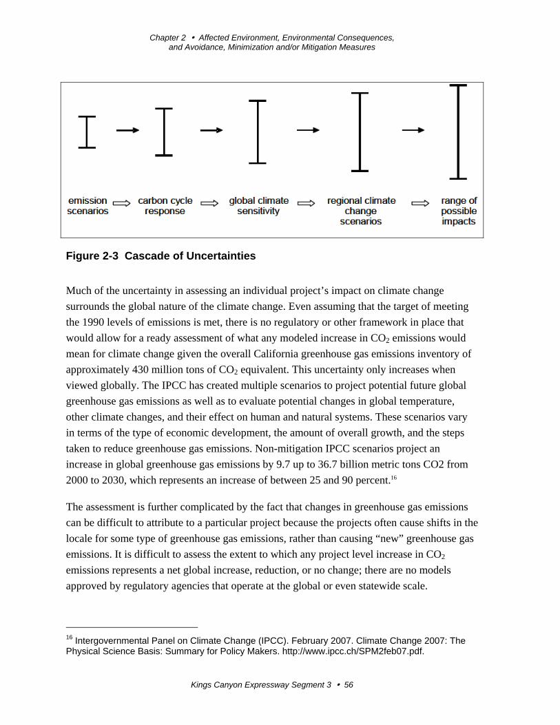
Chapter 2 Affected Environment, Environmental Consequences, and Avoidance, Minimization and/or Mitigation Measures
Kings Canyon Expressway Segment 3 56
Figure 2-3 Cascade of Uncertainties
Much of the uncertainty in assessing an individual project’s impact on climate change
surrounds the global nature of the climate change. Even assuming that the target of meeting
the 1990 levels of emissions is met, there is no regulatory or other framework in place that
would allow for a ready assessment of what any modeled increase in CO2 emissions would
mean for climate change given the overall California greenhouse gas emissions inventory of
approximately 430 million tons of CO2 equivalent. This uncertainty only increases when
viewed globally. The IPCC has created multiple scenarios to project potential future global
greenhouse gas emissions as well as to evaluate potential changes in global temperature,
other climate changes, and their effect on human and natural systems. These scenarios vary
in terms of the type of economic development, the amount of overall growth, and the steps
taken to reduce greenhouse gas emissions. Non-mitigation IPCC scenarios project an
increase in global greenhouse gas emissions by 9.7 up to 36.7 billion metric tons CO2 from
2000 to 2030, which represents an increase of between 25 and 90 percent.16
The assessment is further complicated by the fact that changes in greenhouse gas emissions
can be difficult to attribute to a particular project because the projects often cause shifts in the
locale for some type of greenhouse gas emissions, rather than causing “new” greenhouse gas
emissions. It is difficult to assess the extent to which any project level increase in CO2
emissions represents a net global increase, reduction, or no change; there are no models
approved by regulatory agencies that operate at the global or even statewide scale.
16 Intergovernmental Panel on Climate Change (IPCC). February 2007. Climate Change 2007: The Physical Science Basis: Summary for Policy Makers. http://www.ipcc.ch/SPM2feb07.pdf.
Chapter 2 Affected Environment, Environmental Consequences, and Avoidance, Minimization and/or Mitigation Measures
Kings Canyon Expressway Segment 3 57
Construction Emissions
Greenhouse gas emissions for transportation projects can be divided into those produced
during construction and those produced during operations. Construction greenhouse gas
emissions include emissions produced as a result of material processing, emissions produced
by onsite construction equipment, and emissions arising from traffic delays due to
construction. These emissions will be produced at different levels throughout the
construction phase; their frequency and occurrence can be reduced through innovations in
plans and specifications and by implementing better traffic management during construction
phases.
In addition, with innovations such as longer pavement lives, improved traffic management
plans, and changes in materials, the greenhouse gas emissions produced during construction
can be mitigated to some degree by longer intervals between maintenance and rehabilitation
events.
CEQA Conclusion
While the project will result in a slight increase in greenhouse gas emissions during
construction, it is anticipated that the project will not result in any increase in operational
greenhouse gas emissions compared to the no-build scenarios. While it is Caltrans’
determination that in the absence of further regulatory or scientific information related to
greenhouse gas emissions and CEQA significance it is too speculative to make a significance
determination regarding the project’s direct impact and its contribution on the cumulative
scale to climate change, Caltrans is firmly committed to implementing measures to help
reduce greenhouse gas emissions. These measures are outlined in the following section.
Greenhouse Gas Reduction Strategies
The Department continues to be involved on the Governor’s Climate Action Team as the
California Air Resources Board works to implement Executive Orders S-3-05 and S-01-07
and help achieve the targets set forth in Assembly Bill 32. Many of the strategies the
Department is using to help meet the targets in Assembly Bill 32 come from then-Governor
Arnold Schwarzenegger’s Strategic Growth Plan for California. The Strategic Growth Plan
targeted a significant decrease in traffic congestion below 2008 levels and a corresponding
reduction in greenhouse emissions, while accommodating growth in population and the
economy. The Strategic Growth Plan relies on a complete systems approach to attain carbon
dioxide (CO2) reduction goals: system monitoring and evaluation, maintenance and
preservation, smart land use and demand management, and operational improvements as
shown in Figure 2-4: Mobility Pyramid.
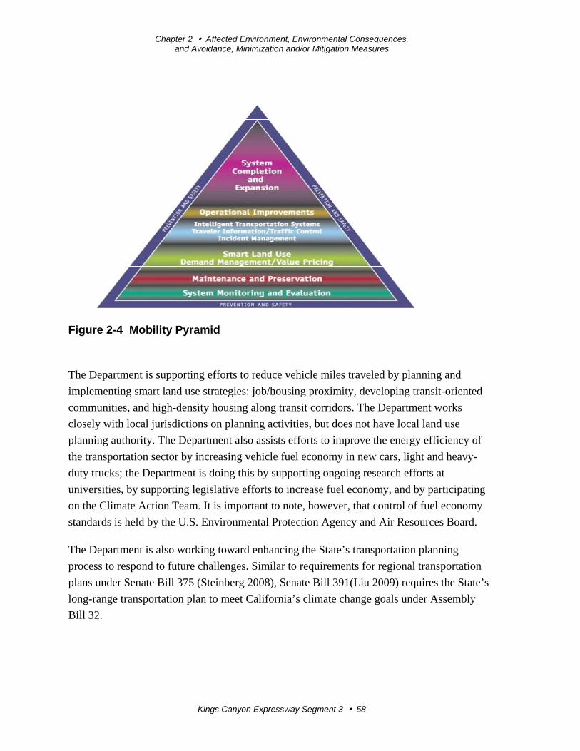
Chapter 2 Affected Environment, Environmental Consequences, and Avoidance, Minimization and/or Mitigation Measures
Kings Canyon Expressway Segment 3 58
Figure 2-4 Mobility Pyramid
The Department is supporting efforts to reduce vehicle miles traveled by planning and
implementing smart land use strategies: job/housing proximity, developing transit-oriented
communities, and high-density housing along transit corridors. The Department works
closely with local jurisdictions on planning activities, but does not have local land use
planning authority. The Department also assists efforts to improve the energy efficiency of
the transportation sector by increasing vehicle fuel economy in new cars, light and heavy-
duty trucks; the Department is doing this by supporting ongoing research efforts at
universities, by supporting legislative efforts to increase fuel economy, and by participating
on the Climate Action Team. It is important to note, however, that control of fuel economy
standards is held by the U.S. Environmental Protection Agency and Air Resources Board.
The Department is also working toward enhancing the State’s transportation planning
process to respond to future challenges. Similar to requirements for regional transportation
plans under Senate Bill 375 (Steinberg 2008), Senate Bill 391(Liu 2009) requires the State’s
long-range transportation plan to meet California’s climate change goals under Assembly
Bill 32.
Chapter 2 Affected Environment, Environmental Consequences, and Avoidance, Minimization and/or Mitigation Measures
Kings Canyon Expressway Segment 3 59
The California Transportation Plan (CTP) is a statewide, long-range transportation plan to
meet our future mobility needs and reduce greenhouse gas emissions. The California
Transportation Plan defines performance-based goals, policies, and strategies to achieve our
collective vision for California’s future, statewide, integrated, multimodal transportation
system.
The purpose of the California Transportation Plan is to provide a common policy framework
that will guide transportation investments and decisions by all levels of government, the
private sector, and other transportation stakeholders. Through this policy framework, the
California Transportation Plan 2040 will identify the statewide transportation system needed
to achieve maximum feasible greenhouse gas emission reductions while meeting the State’s
transportation needs.
Table 2.5 summarizes the Department and statewide efforts being implementing to reduce
greenhouse emissions. More detailed information about each strategy is included in the
Climate Action Program at Caltrans (December 2006).
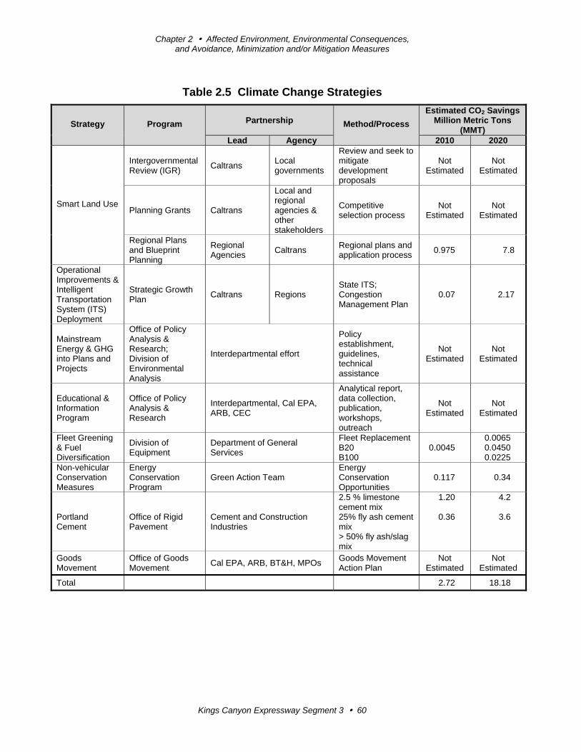
Chapter 2 Affected Environment, Environmental Consequences, and Avoidance, Minimization and/or Mitigation Measures
Kings Canyon Expressway Segment 3 60
Table 2.5 Climate Change Strategies
Strategy Program Partnership Method/Process
Estimated CO2 Savings Million Metric Tons
(MMT) Lead Agency 2010 2020
Smart Land Use
Intergovernmental Review (IGR)
Caltrans Local governments
Review and seek to mitigate development proposals
Not Estimated
Not Estimated
Planning Grants Caltrans
Local and regional agencies & other stakeholders
Competitive selection process
Not Estimated
Not Estimated
Regional Plans and Blueprint Planning
Regional Agencies
Caltrans Regional plans and application process
0.975 7.8
Operational Improvements & Intelligent Transportation System (ITS) Deployment
Strategic Growth Plan
Caltrans Regions State ITS; Congestion Management Plan
0.07 2.17
Mainstream Energy & GHG into Plans and Projects
Office of Policy Analysis & Research; Division of Environmental Analysis
Interdepartmental effort
Policy establishment, guidelines, technical assistance
Not Estimated
Not Estimated
Educational & Information Program
Office of Policy Analysis & Research
Interdepartmental, Cal EPA, ARB, CEC
Analytical report, data collection, publication, workshops, outreach
Not Estimated
Not Estimated
Fleet Greening & Fuel Diversification
Division of Equipment
Department of General Services
Fleet Replacement B20 B100
0.0045 0.0065 0.0450 0.0225
Non-vehicular Conservation Measures
Energy Conservation Program
Green Action Team Energy Conservation Opportunities
0.117 0.34
Portland Cement
Office of Rigid Pavement
Cement and Construction Industries
2.5 % limestone cement mix 25% fly ash cement mix > 50% fly ash/slag mix
1.20
0.36
4.2
3.6
Goods Movement
Office of Goods Movement
Cal EPA, ARB, BT&H, MPOs Goods Movement Action Plan
Not Estimated
Not Estimated
Total 2.72 18.18
Chapter 2 Affected Environment, Environmental Consequences, and Avoidance, Minimization and/or Mitigation Measures
Kings Canyon Expressway Segment 3 61
The Caltrans Director’s Policy 30 (DP-30) Climate Change (June 22, 2012) is intended to
establish a Department policy that will ensure coordinated efforts to incorporate climate
change into Departmental decisions and activities.
Caltrans Activities to Address Climate Change (April 2013)17 provides a comprehensive
overview of activities undertaken by Caltrans statewide to reduce greenhouse gas emissions
resulting from agency operations.
The following measures will also be included in the project to reduce the greenhouse gas
emissions and potential climate change impacts from the project:
Landscaping reduces surface warming and, through photosynthesis, decreases carbon
dioxide (CO2). The project would seed slopes, drainage channels, and other disturbed
areas with native and drought-tolerant shrubs, perennials, and grasses but would not
obstruct the view of the mountains or interfere with the floodway.
The project would incorporate the use of energy-efficient lighting, such as LED
traffic signals.
According to Caltrans Standard Specifications, the contractor must comply with all
local Air Pollution Control District (APCD) rules, ordinances, and regulations for air
quality restrictions.
In 2008, the Air Resources Board (ARB) adopted a regulation for In-Use Off-Road
Diesel Vehicles, which restricts idling time during construction to 5 consecutive
minutes (Advisory Number 377, June 2008 California Environmental Protection
Agency, Air Resources Board).
Also, the Council of Fresno County Governments provides ridesharing services and park-
and-ride facilities. A park-and-ride facility is not planned for this segment of the State Route
180 Expressway, but was constructed within Segment 1 of the Kings Canyon Expressway
Project. Also, Valleyrides.com, in cooperation with the Council of Fresno County
Governments, established the following website, Climate Change Information Portal, which
provides links to information on climate change:
http://www.fresnocog.org/files/Air%20Quality/Climate%20Change/website%20content5-14-
09.pdf
17 http://www.dot.ca.gov/hq/tpp/offices/orip/climate_change/projects_and_studies.shtml
Chapter 2 Affected Environment, Environmental Consequences, and Avoidance, Minimization and/or Mitigation Measures
Kings Canyon Expressway Segment 3 62
Adaptation Strategies
“Adaptation strategies” refer to how the Department and others can plan for the effects of
climate change on the State’s transportation infrastructure and strengthen or protect the
facilities from damage. Climate change is expected to produce increased variability in
precipitation, rising temperatures, rising sea levels, variability in storm surges and intensity,
and the frequency and intensity of wildfires. These changes may affect the transportation
infrastructure in various ways, such as damage to roadbeds from longer periods of intense
heat; increased storm damage from flooding and erosion; and inundation from rising sea
levels. These effects will vary by location and may, in the most extreme cases, require that a
facility be relocated or redesigned. There may also be economic and strategic ramifications
as a result of these types of impacts to the transportation infrastructure.
At the federal level, the Climate Change Adaptation Task Force, co-chaired by the Council
on Environmental Quality (CEQ), the Office of Science and Technology Policy (OSTP), and
the National Oceanic and Atmospheric Administration (NOAA), released its interagency task
force progress report on October 28, 2011,18 outlining the federal government’s progress in
expanding and strengthening the nation’s capacity to better understand, prepare for, and
respond to extreme events and other climate change impacts. The report provides an update
on actions in key areas of federal adaptation, including: building resilience in local
communities, safeguarding critical natural resources such as freshwater, and providing
accessible climate information and tools to help decision-makers manage climate risks.
Climate change adaptation must also involve the natural environment as well. Efforts are
underway on a statewide level to develop strategies to cope with impacts to habitat and
biodiversity through planning and conservation. The results of these efforts will help
California agencies plan and implement mitigation strategies for programs and projects.
On November 14, 2008, then-Governor Arnold Schwarzenegger signed Executive Order S-
13-08, which directed a number of state agencies to address California’s vulnerability to sea
level rise caused by climate change. This order set in motion several agencies and actions to
address the concern of sea level rise. In addition to addressing projected sea level rise, the
California Natural Resources Agency (Resources Agency) was directed to coordinate with
local, regional, state and federal public and private entities to develop The California Climate
Adaptation Strategy (Dec 2009),19 which summarizes the best-known science on climate
18 http://www.whitehouse.gov/administration/eop/ceq/initiatives/adaptation 19 http://www.energy.ca.gov/2009publications/CNRA-1000-2009-027/CNRA-1000-2009-027-F.PDF
Chapter 2 Affected Environment, Environmental Consequences, and Avoidance, Minimization and/or Mitigation Measures
Kings Canyon Expressway Segment 3 63
change impacts to California, assesses California’s vulnerability to the identified impacts,
and then outlines solutions that can be implemented within and across state agencies to
promote resiliency.
The strategy outline is in direct response to Executive Order S-13-08 that specifically asked
the Resources Agency to identify how state agencies can respond to rising temperatures,
changing precipitation patterns, sea level rise, and extreme natural events. Numerous other
state agencies were involved in the creation of the Adaptation Strategy document, including
the California Environmental Protection Agency; Business, Transportation and Housing
(now called the Transportation Agency); Health and Human Services; and the Department of
Agriculture. The document is broken down into strategies for different sectors that include:
public health; biodiversity and habitat; ocean and coastal resources; water management;
agriculture; forestry; and transportation and energy infrastructure. As data continue to be
developed and collected, the State’s adaptation strategy will be updated to reflect current
findings.
The National Academy of Science was directed to prepare a Sea Level Rise Assessment
Report20 to recommend how California should plan for future sea level rise. The report was
released in June 2012 and included the following:
The relative sea level rise projections for California, Oregon, and Washington, taking
into account coastal erosion rates, tidal impacts, El Niño and La Niña events, storm
surge and land subsidence rates.
The range of uncertainty in selected sea level rise projections.
A synthesis of existing information on projected sea level rise impacts to state
infrastructure (such as roads, public facilities and beaches), natural areas, and coastal
and marine ecosystems.
A discussion of future research needs regarding sea level rise.
In 2010, interim guidance was released by the Coastal Ocean Climate Action Team (CO-
CAT) as well as Caltrans as a method to initiate action and discussion of potential risks to the
State’s infrastructure due to projected sea level rise. Subsequently, the Coastal Ocean
Climate Action Team updated the Sea Level Rise guidance to include information presented
in the National Academy’s study.
20 Sea Level Rise for the Coasts of California, Oregon, and Washington: Past, Present, and Future (2012) is available at: http://www.nap.edu/catalog.php?record_id=13389.
Chapter 2 Affected Environment, Environmental Consequences, and Avoidance, Minimization and/or Mitigation Measures
Kings Canyon Expressway Segment 3 64
All state agencies that are planning to construct projects in areas vulnerable to future sea
level rise are directed to consider a range of sea level rise scenarios for the years 2050 and
2100 to assess project vulnerability and, to the extent feasible, reduce expected risks and
increase resiliency to sea level rise. Sea level rise estimates should also be used in
conjunction with information on local uplift and subsidence, coastal erosion rates, predicted
higher high water levels, storm surge and storm wave data.
All projects that have filed a Notice of Preparation (NOP) as of the date of Executive Order
S-13-08, and/or are programmed for construction funding through 2013, or are routine
maintenance projects may, but are not required to, consider these planning guidelines. As
part of the California Environmental Quality Act, an NOP was filed for the 1995
Environmental Impact Report in February 1991, and a subsequent NOP was filed for this
Draft Supplemental EIR on January 28, 2014. However, the project is outside the coastal
zone, and direct impacts to transportation facilities due to projected sea level rise are not
expected.
Executive Order S-13-08 also directed the Business, Transportation, and Housing Agency
(now the Transportation Agency) to prepare a report to assess vulnerability of transportation
systems to sea level rise affecting safety, maintenance and operational improvements of the
system, and economy of the state. The Department continues to work on assessing the
transportation system vulnerability to climate change, including the effect of sea level rise.
Currently, the Department is working to assess which transportation facilities are at greatest
risk from climate change effects. However, without statewide planning scenarios for relative
sea level rise and other climate change effects, the Department has not been able to determine
what change, if any, may be made to its design standards for its transportation facilities. Once
statewide planning scenarios become available, the Department will be able review its
current design standards to determine what changes, if any, may be needed to protect the
transportation system from sea level rise.
Climate change adaptation for transportation infrastructure involves long-term planning and
risk management to address vulnerabilities in the transportation system from increased
precipitation and flooding; the increased frequency and intensity of storms and wildfires;
rising temperatures; and rising sea levels. The Department is an active participant in the
efforts being conducted in response to Executive Order S-13-08 and is mobilizing to be able
to respond to the National Academy of Science Sea Level Rise Assessment Report.
Kings Canyon Expressway Segment 3 65
Appendix A California Environmental Quality Act (CEQA) Checklist
This draft environmental document for Segment 3 is a supplemental report to the
previously prepared and certified State Route 180 Improvement Project Final
Environmental Impact Report, and presents additional analysis or information in regard
to only parks and recreational facilities, relocations, utilities/emergency services,
traffic/pedestrian and bicycle facilities, climate change, and biological impacts (natural
communities, wetlands and other waters, and threatened and endangered species)
resulting from changes to the design of the project and new laws or regulations.
The California Environmental Quality Act impact levels include “potentially significant
impact,” “less than significant impact with mitigation,” “less than significant impact,”
and “no impact.” The 1995 Environmental Impact Report did not include a California
Environmental Quality Act checklist or determine impact threshold. The following
checklist includes the impact levels of the unchanged impact areas based on the original
1995 Environmental Impact Report for the entire project, Segments 1-4, but the
supporting documentation is explained in the original 1995 document.
The impact areas that are affected by the new or changed design items of the project
(Segment 3 only) are indicated by a line in the margin, and supporting documentation for
the new checklist items is discussed in Chapter 2.
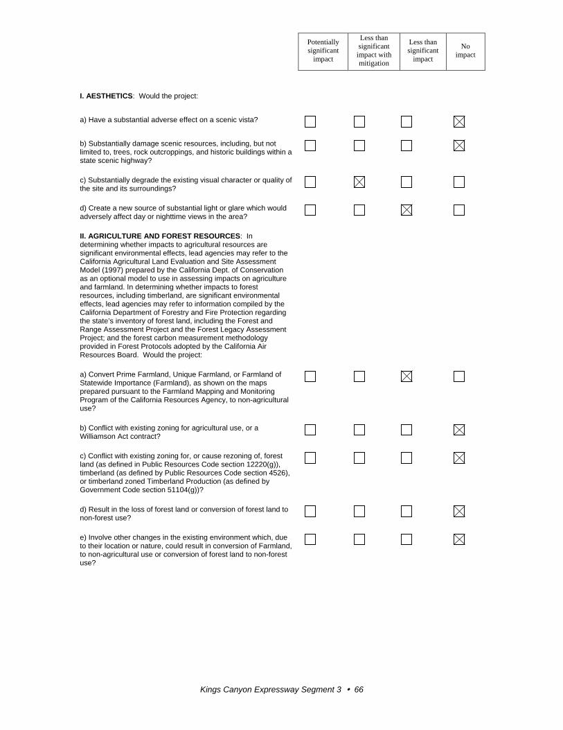
Potentially significant
impact
Less than significant
impact with mitigation
Less than significant
impact
No impact
Kings Canyon Expressway Segment 3 66
I. AESTHETICS: Would the project:
a) Have a substantial adverse effect on a scenic vista?
b) Substantially damage scenic resources, including, but not limited to, trees, rock outcroppings, and historic buildings within a state scenic highway?
c) Substantially degrade the existing visual character or quality of the site and its surroundings?
d) Create a new source of substantial light or glare which would adversely affect day or nighttime views in the area?
II. AGRICULTURE AND FOREST RESOURCES: In determining whether impacts to agricultural resources are significant environmental effects, lead agencies may refer to the California Agricultural Land Evaluation and Site Assessment Model (1997) prepared by the California Dept. of Conservation as an optional model to use in assessing impacts on agriculture and farmland. In determining whether impacts to forest resources, including timberland, are significant environmental effects, lead agencies may refer to information compiled by the California Department of Forestry and Fire Protection regarding the state’s inventory of forest land, including the Forest and Range Assessment Project and the Forest Legacy Assessment Project; and the forest carbon measurement methodology provided in Forest Protocols adopted by the California Air Resources Board. Would the project:
a) Convert Prime Farmland, Unique Farmland, or Farmland of Statewide Importance (Farmland), as shown on the maps prepared pursuant to the Farmland Mapping and Monitoring Program of the California Resources Agency, to non-agricultural use?
b) Conflict with existing zoning for agricultural use, or a Williamson Act contract?
c) Conflict with existing zoning for, or cause rezoning of, forest land (as defined in Public Resources Code section 12220(g)), timberland (as defined by Public Resources Code section 4526), or timberland zoned Timberland Production (as defined by Government Code section 51104(g))?
d) Result in the loss of forest land or conversion of forest land to non-forest use?
e) Involve other changes in the existing environment which, due to their location or nature, could result in conversion of Farmland, to non-agricultural use or conversion of forest land to non-forest use?
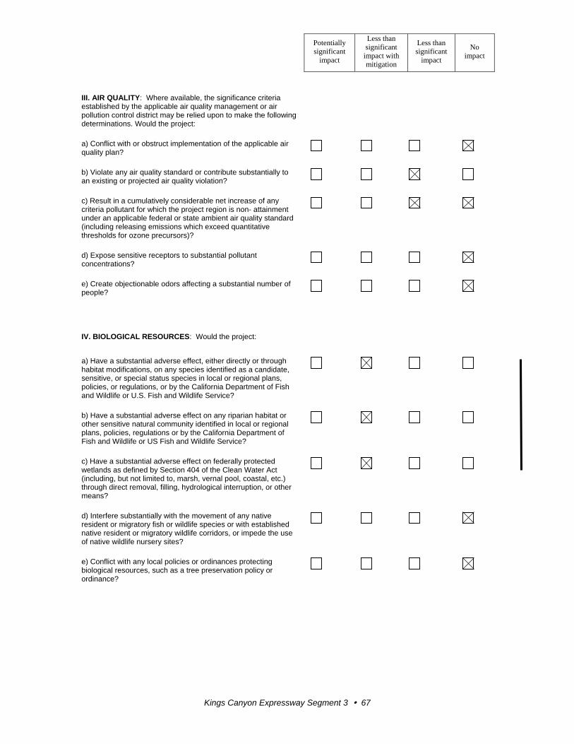
Potentially significant
impact
Less than significant
impact with mitigation
Less than significant
impact
No impact
Kings Canyon Expressway Segment 3 67
III. AIR QUALITY: Where available, the significance criteria established by the applicable air quality management or air pollution control district may be relied upon to make the following determinations. Would the project:
a) Conflict with or obstruct implementation of the applicable air quality plan?
b) Violate any air quality standard or contribute substantially to an existing or projected air quality violation?
c) Result in a cumulatively considerable net increase of any criteria pollutant for which the project region is non- attainment under an applicable federal or state ambient air quality standard (including releasing emissions which exceed quantitative thresholds for ozone precursors)?
d) Expose sensitive receptors to substantial pollutant concentrations?
e) Create objectionable odors affecting a substantial number of people?
IV. BIOLOGICAL RESOURCES: Would the project:
a) Have a substantial adverse effect, either directly or through habitat modifications, on any species identified as a candidate, sensitive, or special status species in local or regional plans, policies, or regulations, or by the California Department of Fish and Wildlife or U.S. Fish and Wildlife Service?
b) Have a substantial adverse effect on any riparian habitat or other sensitive natural community identified in local or regional plans, policies, regulations or by the California Department of Fish and Wildlife or US Fish and Wildlife Service?
c) Have a substantial adverse effect on federally protected wetlands as defined by Section 404 of the Clean Water Act (including, but not limited to, marsh, vernal pool, coastal, etc.) through direct removal, filling, hydrological interruption, or other means?
d) Interfere substantially with the movement of any native resident or migratory fish or wildlife species or with established native resident or migratory wildlife corridors, or impede the use of native wildlife nursery sites?
e) Conflict with any local policies or ordinances protecting biological resources, such as a tree preservation policy or ordinance?
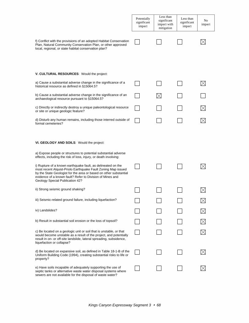
Potentially significant
impact
Less than significant
impact with mitigation
Less than significant
impact
No impact
Kings Canyon Expressway Segment 3 68
f) Conflict with the provisions of an adopted Habitat Conservation Plan, Natural Community Conservation Plan, or other approved local, regional, or state habitat conservation plan?
V. CULTURAL RESOURCES: Would the project:
a) Cause a substantial adverse change in the significance of a historical resource as defined in §15064.5?
b) Cause a substantial adverse change in the significance of an archaeological resource pursuant to §15064.5?
c) Directly or indirectly destroy a unique paleontological resource or site or unique geologic feature?
d) Disturb any human remains, including those interred outside of formal cemeteries?
VI. GEOLOGY AND SOILS: Would the project:
a) Expose people or structures to potential substantial adverse effects, including the risk of loss, injury, or death involving:
i) Rupture of a known earthquake fault, as delineated on the most recent Alquist-Priolo Earthquake Fault Zoning Map issued by the State Geologist for the area or based on other substantial evidence of a known fault? Refer to Division of Mines and Geology Special Publication 42?
ii) Strong seismic ground shaking?
iii) Seismic-related ground failure, including liquefaction?
iv) Landslides?
b) Result in substantial soil erosion or the loss of topsoil?
c) Be located on a geologic unit or soil that is unstable, or that would become unstable as a result of the project, and potentially result in on- or off-site landslide, lateral spreading, subsidence, liquefaction or collapse?
d) Be located on expansive soil, as defined in Table 18-1-B of the Uniform Building Code (1994), creating substantial risks to life or property?
e) Have soils incapable of adequately supporting the use of septic tanks or alternative waste water disposal systems where sewers are not available for the disposal of waste water?
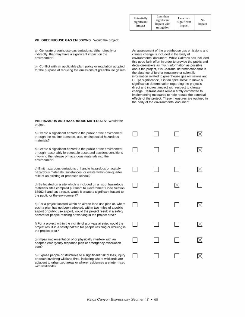
Potentially significant
impact
Less than significant
impact with mitigation
Less than significant
impact
No impact
Kings Canyon Expressway Segment 3 69
VII. GREENHOUSE GAS EMISSIONS: Would the project:
a) Generate greenhouse gas emissions, either directly or indirectly, that may have a significant impact on the environment?
An assessment of the greenhouse gas emissions and climate change is included in the body of environmental document. While Caltrans has included this good faith effort in order to provide the public and decision-makers as much information as possible about the project, it is Caltrans’ determination that in the absence of further regulatory or scientific information related to greenhouse gas emissions and CEQA significance, it is too speculative to make a significance determination regarding the project’s direct and indirect impact with respect to climate change. Caltrans does remain firmly committed to implementing measures to help reduce the potential effects of the project. These measures are outlined in the body of the environmental document.
b) Conflict with an applicable plan, policy or regulation adopted for the purpose of reducing the emissions of greenhouse gases?
VIII. HAZARDS AND HAZARDOUS MATERIALS: Would the project:
a) Create a significant hazard to the public or the environment through the routine transport, use, or disposal of hazardous materials?
b) Create a significant hazard to the public or the environment through reasonably foreseeable upset and accident conditions involving the release of hazardous materials into the environment?
c) Emit hazardous emissions or handle hazardous or acutely hazardous materials, substances, or waste within one-quarter mile of an existing or proposed school?
d) Be located on a site which is included on a list of hazardous materials sites compiled pursuant to Government Code Section 65962.5 and, as a result, would it create a significant hazard to the public or the environment?
e) For a project located within an airport land use plan or, where such a plan has not been adopted, within two miles of a public airport or public use airport, would the project result in a safety hazard for people residing or working in the project area?
f) For a project within the vicinity of a private airstrip, would the project result in a safety hazard for people residing or working in the project area?
g) Impair implementation of or physically interfere with an adopted emergency response plan or emergency evacuation plan?
h) Expose people or structures to a significant risk of loss, injury or death involving wildland fires, including where wildlands are adjacent to urbanized areas or where residences are intermixed with wildlands?
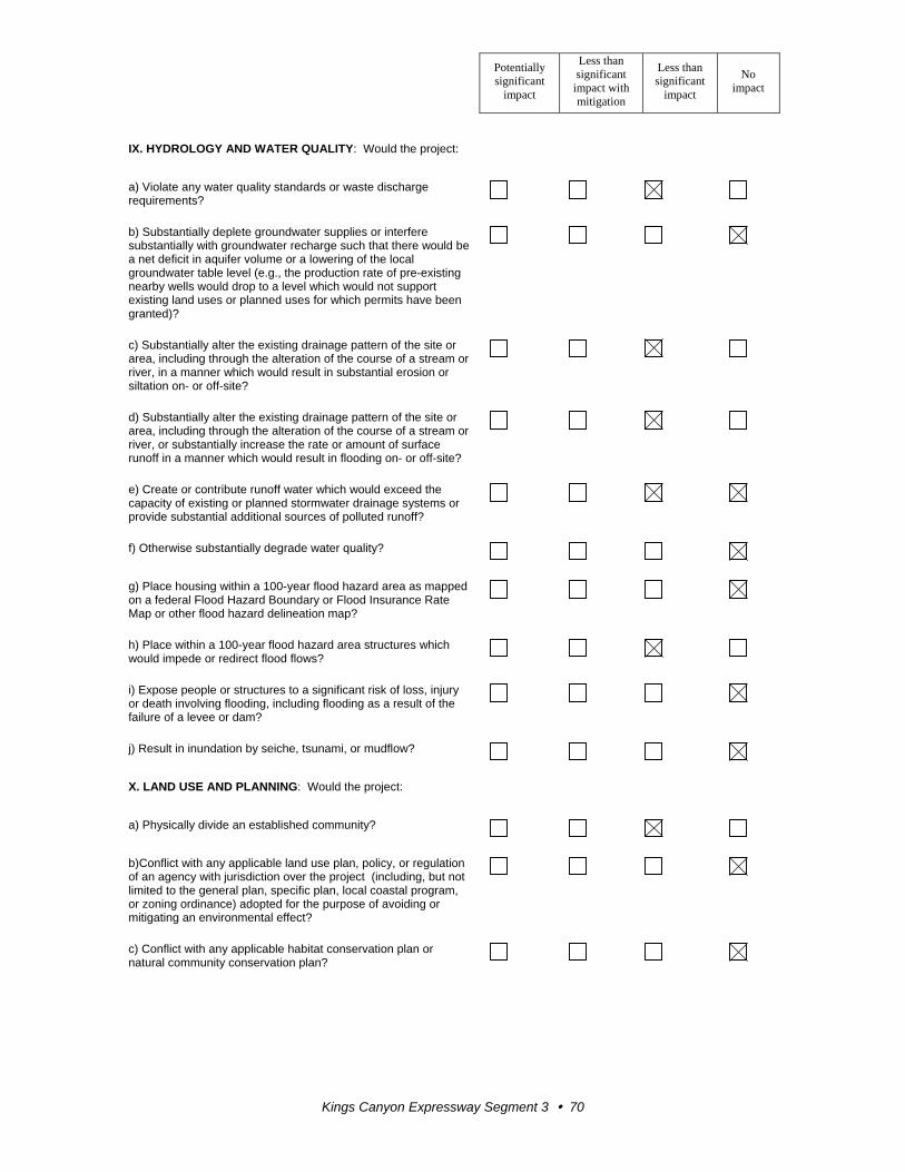
Potentially significant
impact
Less than significant
impact with mitigation
Less than significant
impact
No impact
Kings Canyon Expressway Segment 3 70
IX. HYDROLOGY AND WATER QUALITY: Would the project:
a) Violate any water quality standards or waste discharge requirements?
b) Substantially deplete groundwater supplies or interfere substantially with groundwater recharge such that there would be a net deficit in aquifer volume or a lowering of the local groundwater table level (e.g., the production rate of pre-existing nearby wells would drop to a level which would not support existing land uses or planned uses for which permits have been granted)?
c) Substantially alter the existing drainage pattern of the site or area, including through the alteration of the course of a stream or river, in a manner which would result in substantial erosion or siltation on- or off-site?
d) Substantially alter the existing drainage pattern of the site or area, including through the alteration of the course of a stream or river, or substantially increase the rate or amount of surface runoff in a manner which would result in flooding on- or off-site?
e) Create or contribute runoff water which would exceed the capacity of existing or planned stormwater drainage systems or provide substantial additional sources of polluted runoff?
f) Otherwise substantially degrade water quality?
g) Place housing within a 100-year flood hazard area as mapped on a federal Flood Hazard Boundary or Flood Insurance Rate Map or other flood hazard delineation map?
h) Place within a 100-year flood hazard area structures which would impede or redirect flood flows?
i) Expose people or structures to a significant risk of loss, injury or death involving flooding, including flooding as a result of the failure of a levee or dam?
j) Result in inundation by seiche, tsunami, or mudflow?
X. LAND USE AND PLANNING: Would the project:
a) Physically divide an established community?
b)Conflict with any applicable land use plan, policy, or regulation of an agency with jurisdiction over the project (including, but not limited to the general plan, specific plan, local coastal program, or zoning ordinance) adopted for the purpose of avoiding or mitigating an environmental effect?
c) Conflict with any applicable habitat conservation plan or natural community conservation plan?
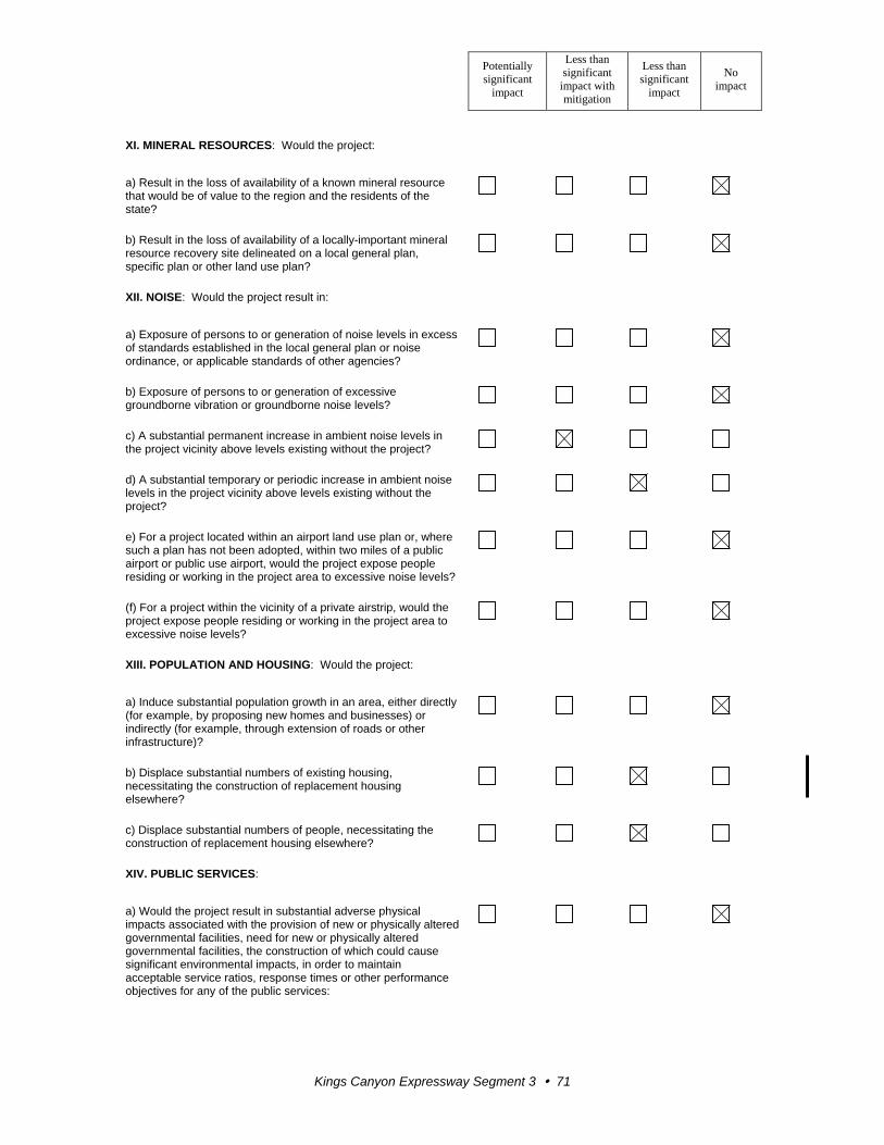
Potentially significant
impact
Less than significant
impact with mitigation
Less than significant
impact
No impact
Kings Canyon Expressway Segment 3 71
XI. MINERAL RESOURCES: Would the project:
a) Result in the loss of availability of a known mineral resource that would be of value to the region and the residents of the state?
b) Result in the loss of availability of a locally-important mineral resource recovery site delineated on a local general plan, specific plan or other land use plan?
XII. NOISE: Would the project result in:
a) Exposure of persons to or generation of noise levels in excess of standards established in the local general plan or noise ordinance, or applicable standards of other agencies?
b) Exposure of persons to or generation of excessive groundborne vibration or groundborne noise levels?
c) A substantial permanent increase in ambient noise levels in the project vicinity above levels existing without the project?
d) A substantial temporary or periodic increase in ambient noise levels in the project vicinity above levels existing without the project?
e) For a project located within an airport land use plan or, where such a plan has not been adopted, within two miles of a public airport or public use airport, would the project expose people residing or working in the project area to excessive noise levels?
(f) For a project within the vicinity of a private airstrip, would the project expose people residing or working in the project area to excessive noise levels?
XIII. POPULATION AND HOUSING: Would the project:
a) Induce substantial population growth in an area, either directly (for example, by proposing new homes and businesses) or indirectly (for example, through extension of roads or other infrastructure)?
b) Displace substantial numbers of existing housing, necessitating the construction of replacement housing elsewhere?
c) Displace substantial numbers of people, necessitating the construction of replacement housing elsewhere?
XIV. PUBLIC SERVICES:
a) Would the project result in substantial adverse physical impacts associated with the provision of new or physically altered governmental facilities, need for new or physically altered governmental facilities, the construction of which could cause significant environmental impacts, in order to maintain acceptable service ratios, response times or other performance objectives for any of the public services:
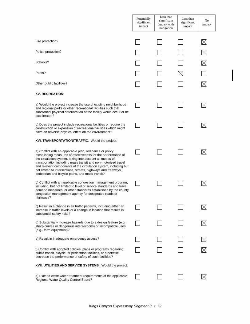
Potentially significant
impact
Less than significant
impact with mitigation
Less than significant
impact
No impact
Kings Canyon Expressway Segment 3 72
Fire protection?
Police protection?
Schools?
Parks?
Other public facilities?
XV. RECREATION:
a) Would the project increase the use of existing neighborhood and regional parks or other recreational facilities such that substantial physical deterioration of the facility would occur or be accelerated?
b) Does the project include recreational facilities or require the construction or expansion of recreational facilities which might have an adverse physical effect on the environment?
XVI. TRANSPORTATION/TRAFFIC: Would the project:
a) Conflict with an applicable plan, ordinance or policy establishing measures of effectiveness for the performance of the circulation system, taking into account all modes of transportation including mass transit and non-motorized travel and relevant components of the circulation system, including but not limited to intersections, streets, highways and freeways, pedestrian and bicycle paths, and mass transit?
b) Conflict with an applicable congestion management program, including, but not limited to level of service standards and travel demand measures, or other standards established by the county congestion management agency for designated roads or highways?
c) Result in a change in air traffic patterns, including either an increase in traffic levels or a change in location that results in substantial safety risks?
d) Substantially increase hazards due to a design feature (e.g., sharp curves or dangerous intersections) or incompatible uses (e.g., farm equipment)?
e) Result in inadequate emergency access?
f) Conflict with adopted policies, plans or programs regarding public transit, bicycle, or pedestrian facilities, or otherwise decrease the performance or safety of such facilities?
XVII. UTILITIES AND SERVICE SYSTEMS: Would the project:
a) Exceed wastewater treatment requirements of the applicable Regional Water Quality Control Board?
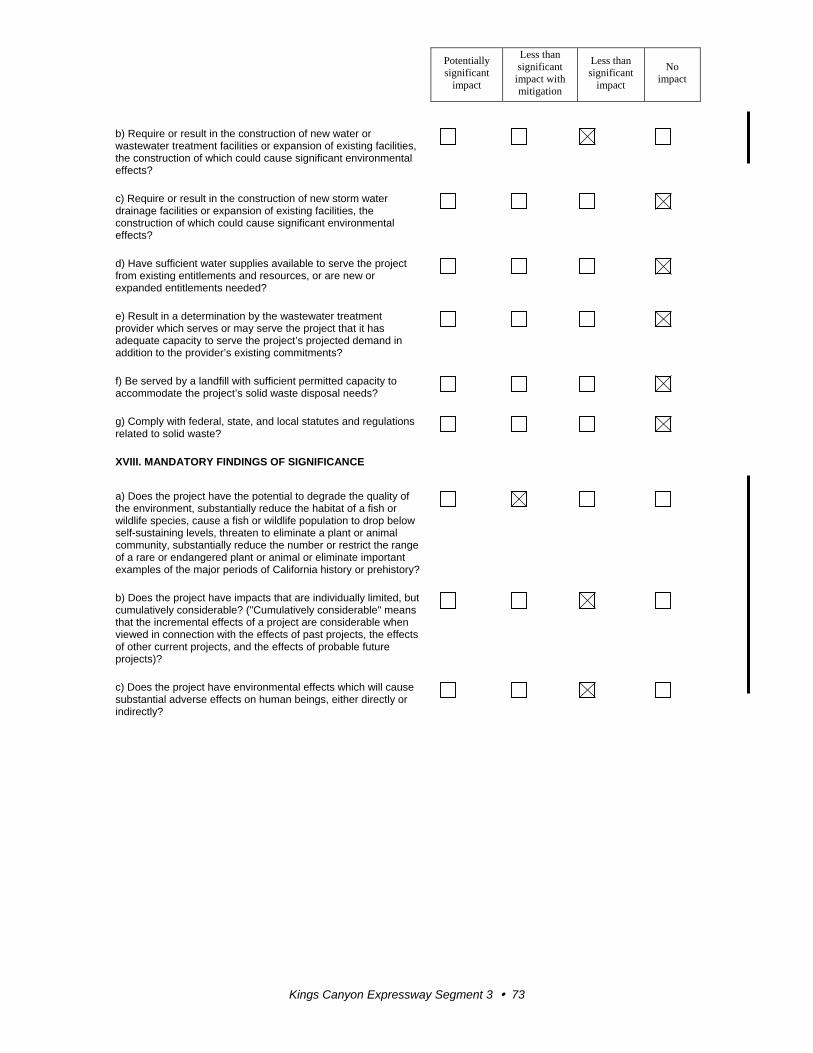
Potentially significant
impact
Less than significant
impact with mitigation
Less than significant
impact
No impact
Kings Canyon Expressway Segment 3 73
b) Require or result in the construction of new water or wastewater treatment facilities or expansion of existing facilities, the construction of which could cause significant environmental effects?
c) Require or result in the construction of new storm water drainage facilities or expansion of existing facilities, the construction of which could cause significant environmental effects?
d) Have sufficient water supplies available to serve the project from existing entitlements and resources, or are new or expanded entitlements needed?
e) Result in a determination by the wastewater treatment provider which serves or may serve the project that it has adequate capacity to serve the project’s projected demand in addition to the provider’s existing commitments?
f) Be served by a landfill with sufficient permitted capacity to accommodate the project’s solid waste disposal needs?
g) Comply with federal, state, and local statutes and regulations related to solid waste?
XVIII. MANDATORY FINDINGS OF SIGNIFICANCE
a) Does the project have the potential to degrade the quality of the environment, substantially reduce the habitat of a fish or wildlife species, cause a fish or wildlife population to drop below self-sustaining levels, threaten to eliminate a plant or animal community, substantially reduce the number or restrict the range of a rare or endangered plant or animal or eliminate important examples of the major periods of California history or prehistory?
b) Does the project have impacts that are individually limited, but cumulatively considerable? ("Cumulatively considerable" means that the incremental effects of a project are considerable when viewed in connection with the effects of past projects, the effects of other current projects, and the effects of probable future projects)?
c) Does the project have environmental effects which will cause substantial adverse effects on human beings, either directly or indirectly?

Kings Canyon Expressway Segment 3 75
Appendix B Summary of New Avoidance, Minimization and Mitigation Measures
Only the new avoidance, minimization, and mitigation measures discussed in this
document are summarized in this appendix. Other measures that remain valid for the
project are included in the 1995 Environmental Impact Report/Environmental Impact
Statement.
Park and Recreation Facilities
Thorburn Park – To minimize impacts during construction, any constructions activities
would be coordinated with the jurisdictional agency, Fresno County, to avoid interruption
to park patrons.
Pierce’s Park Campground, Whispering Waters Recreation Park, and Kampground of
America – To minimize impacts during construction, any constructions activities would
be coordinated with the park or campground to avoid the temporary disruption to patrons
as much as possible.
Kings River – Construction of the bridge across the Kings River would be conducted
during low water levels as much as possible. Efforts to notify the public about temporary
closure to water activities at the river during construction would be made through local
news releases and public notification.
Relocations and Real Property Acquisition
All displacees will be contacted by a Relocation Agent, who will ensure that eligible
displacees receive their full relocation benefits, including advisory assistance, and that all
activities will be conducted in accordance with the Uniform Relocation Assistance and
Real Property Acquisition Policies Act of 1970, as amended. Relocation resources shall
be available to all displacees free of discrimination. At the time of the first written offer
to purchase, owner occupants are given a detailed explanation of Caltrans’ “Relocation
Program and Services.” Tenant occupants of properties to be acquired are contacted soon
after the first written offer to purchase and are given a detailed explanation of Caltrans’
“Relocation Program and Services.” In accordance with the Uniform Relocation
Assistance and Real Property Acquisition Policies Act of 1970, as amended, Caltrans will
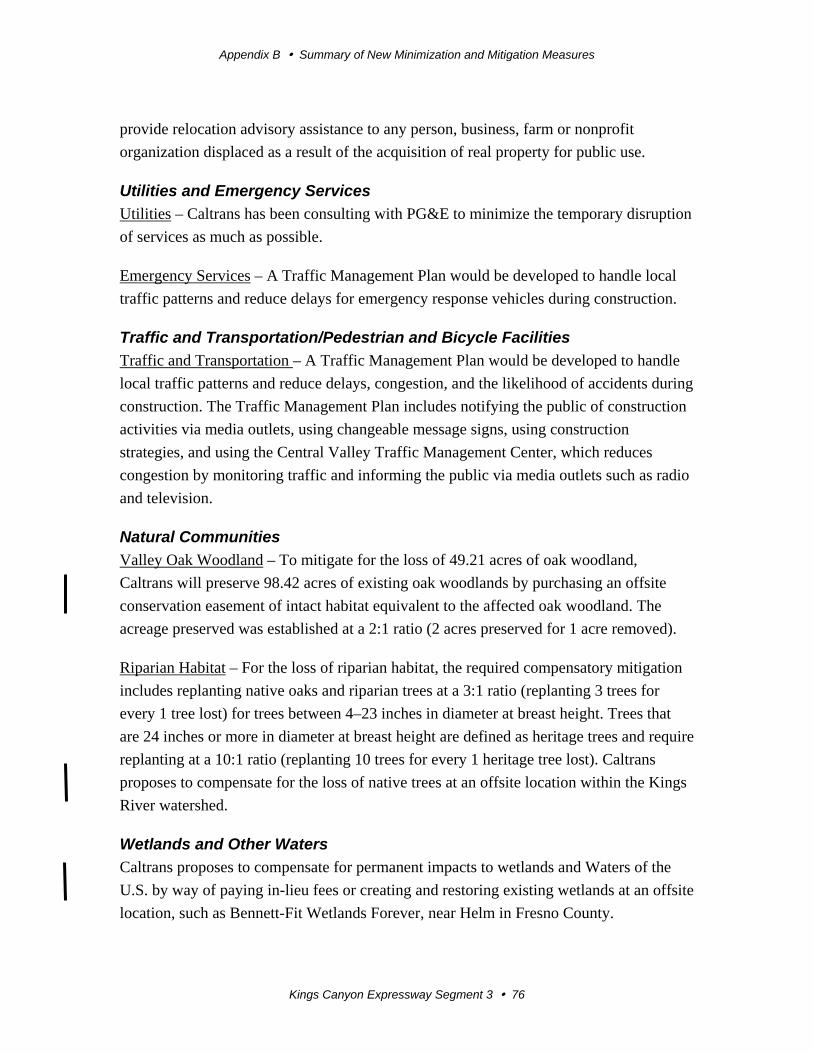
Appendix B Summary of New Minimization and Mitigation Measures
Kings Canyon Expressway Segment 3 76
provide relocation advisory assistance to any person, business, farm or nonprofit
organization displaced as a result of the acquisition of real property for public use.
Utilities and Emergency Services
Utilities – Caltrans has been consulting with PG&E to minimize the temporary disruption
of services as much as possible.
Emergency Services – A Traffic Management Plan would be developed to handle local
traffic patterns and reduce delays for emergency response vehicles during construction.
Traffic and Transportation/Pedestrian and Bicycle Facilities
Traffic and Transportation – A Traffic Management Plan would be developed to handle
local traffic patterns and reduce delays, congestion, and the likelihood of accidents during
construction. The Traffic Management Plan includes notifying the public of construction
activities via media outlets, using changeable message signs, using construction
strategies, and using the Central Valley Traffic Management Center, which reduces
congestion by monitoring traffic and informing the public via media outlets such as radio
and television.
Natural Communities
Valley Oak Woodland – To mitigate for the loss of 49.21 acres of oak woodland,
Caltrans will preserve 98.42 acres of existing oak woodlands by purchasing an offsite
conservation easement of intact habitat equivalent to the affected oak woodland. The
acreage preserved was established at a 2:1 ratio (2 acres preserved for 1 acre removed).
Riparian Habitat – For the loss of riparian habitat, the required compensatory mitigation
includes replanting native oaks and riparian trees at a 3:1 ratio (replanting 3 trees for
every 1 tree lost) for trees between 4–23 inches in diameter at breast height. Trees that
are 24 inches or more in diameter at breast height are defined as heritage trees and require
replanting at a 10:1 ratio (replanting 10 trees for every 1 heritage tree lost). Caltrans
proposes to compensate for the loss of native trees at an offsite location within the Kings
River watershed.
Wetlands and Other Waters
Caltrans proposes to compensate for permanent impacts to wetlands and Waters of the
U.S. by way of paying in-lieu fees or creating and restoring existing wetlands at an offsite
location, such as Bennett-Fit Wetlands Forever, near Helm in Fresno County.
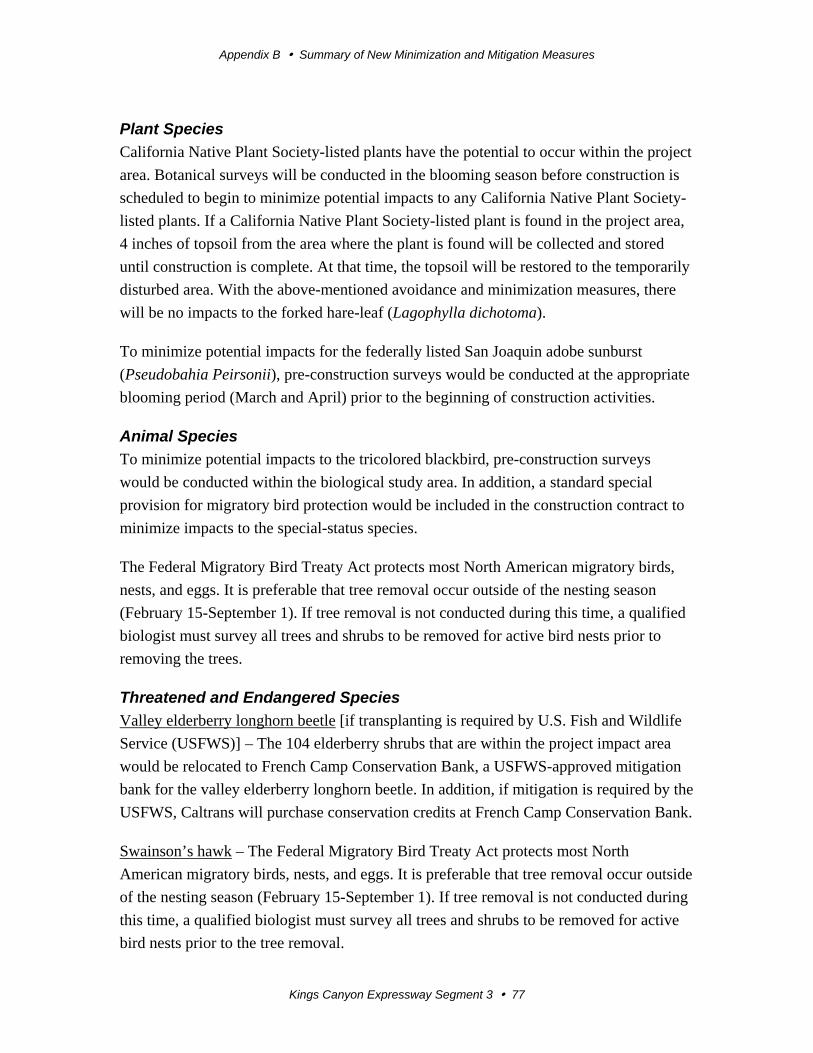
Appendix B Summary of New Minimization and Mitigation Measures
Kings Canyon Expressway Segment 3 77
Plant Species
California Native Plant Society-listed plants have the potential to occur within the project
area. Botanical surveys will be conducted in the blooming season before construction is
scheduled to begin to minimize potential impacts to any California Native Plant Society-
listed plants. If a California Native Plant Society-listed plant is found in the project area,
4 inches of topsoil from the area where the plant is found will be collected and stored
until construction is complete. At that time, the topsoil will be restored to the temporarily
disturbed area. With the above-mentioned avoidance and minimization measures, there
will be no impacts to the forked hare-leaf (Lagophylla dichotoma).
To minimize potential impacts for the federally listed San Joaquin adobe sunburst
(Pseudobahia Peirsonii), pre-construction surveys would be conducted at the appropriate
blooming period (March and April) prior to the beginning of construction activities.
Animal Species
To minimize potential impacts to the tricolored blackbird, pre-construction surveys
would be conducted within the biological study area. In addition, a standard special
provision for migratory bird protection would be included in the construction contract to
minimize impacts to the special-status species.
The Federal Migratory Bird Treaty Act protects most North American migratory birds,
nests, and eggs. It is preferable that tree removal occur outside of the nesting season
(February 15-September 1). If tree removal is not conducted during this time, a qualified
biologist must survey all trees and shrubs to be removed for active bird nests prior to
removing the trees.
Threatened and Endangered Species
Valley elderberry longhorn beetle [if transplanting is required by U.S. Fish and Wildlife
Service (USFWS)] – The 104 elderberry shrubs that are within the project impact area
would be relocated to French Camp Conservation Bank, a USFWS-approved mitigation
bank for the valley elderberry longhorn beetle. In addition, if mitigation is required by the
USFWS, Caltrans will purchase conservation credits at French Camp Conservation Bank.
Swainson’s hawk – The Federal Migratory Bird Treaty Act protects most North
American migratory birds, nests, and eggs. It is preferable that tree removal occur outside
of the nesting season (February 15-September 1). If tree removal is not conducted during
this time, a qualified biologist must survey all trees and shrubs to be removed for active
bird nests prior to the tree removal.

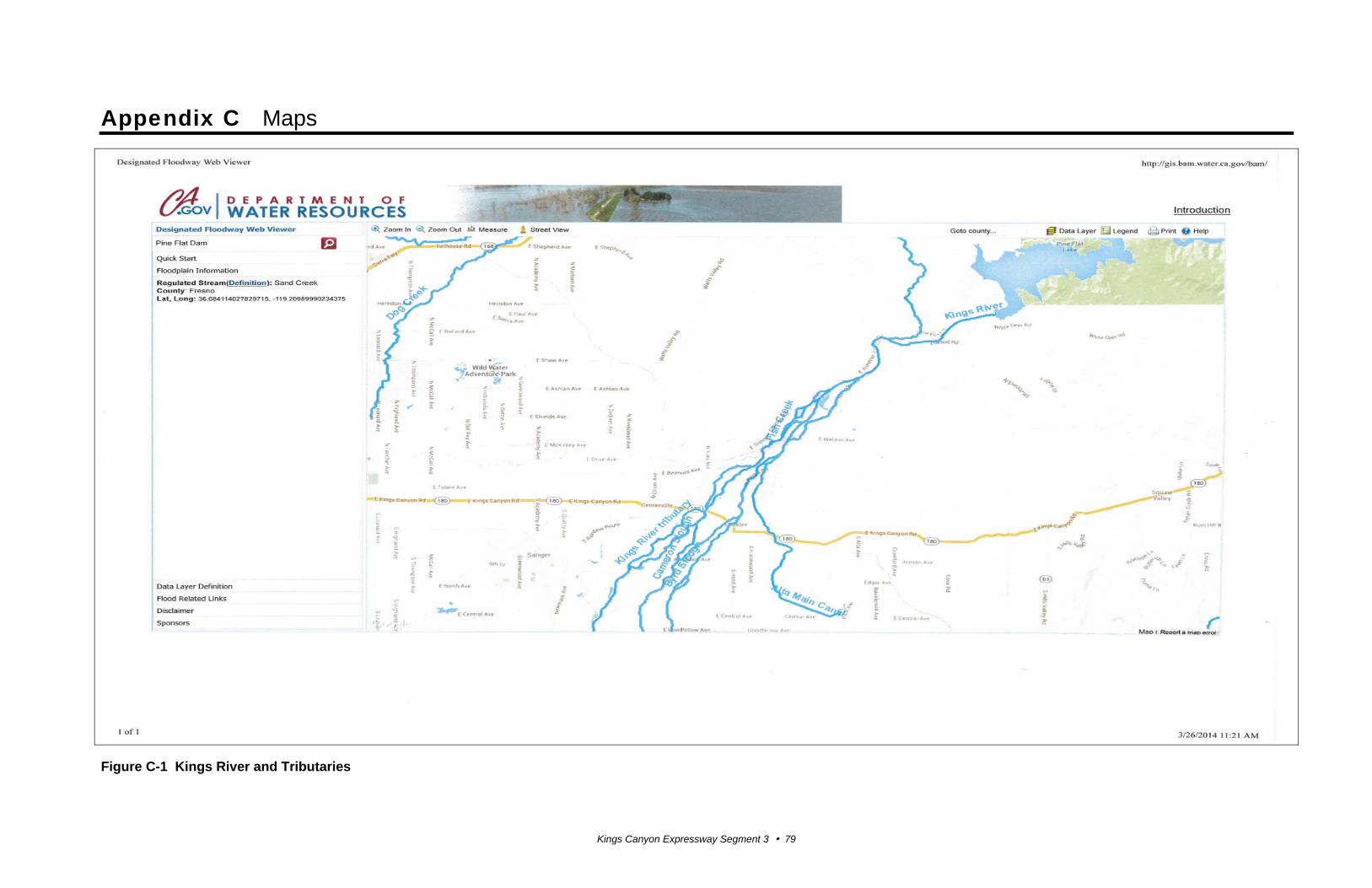
Kings Canyon Expressway Segment 3 79
Appendix C Maps
Figure C-1 Kings River and Tributaries

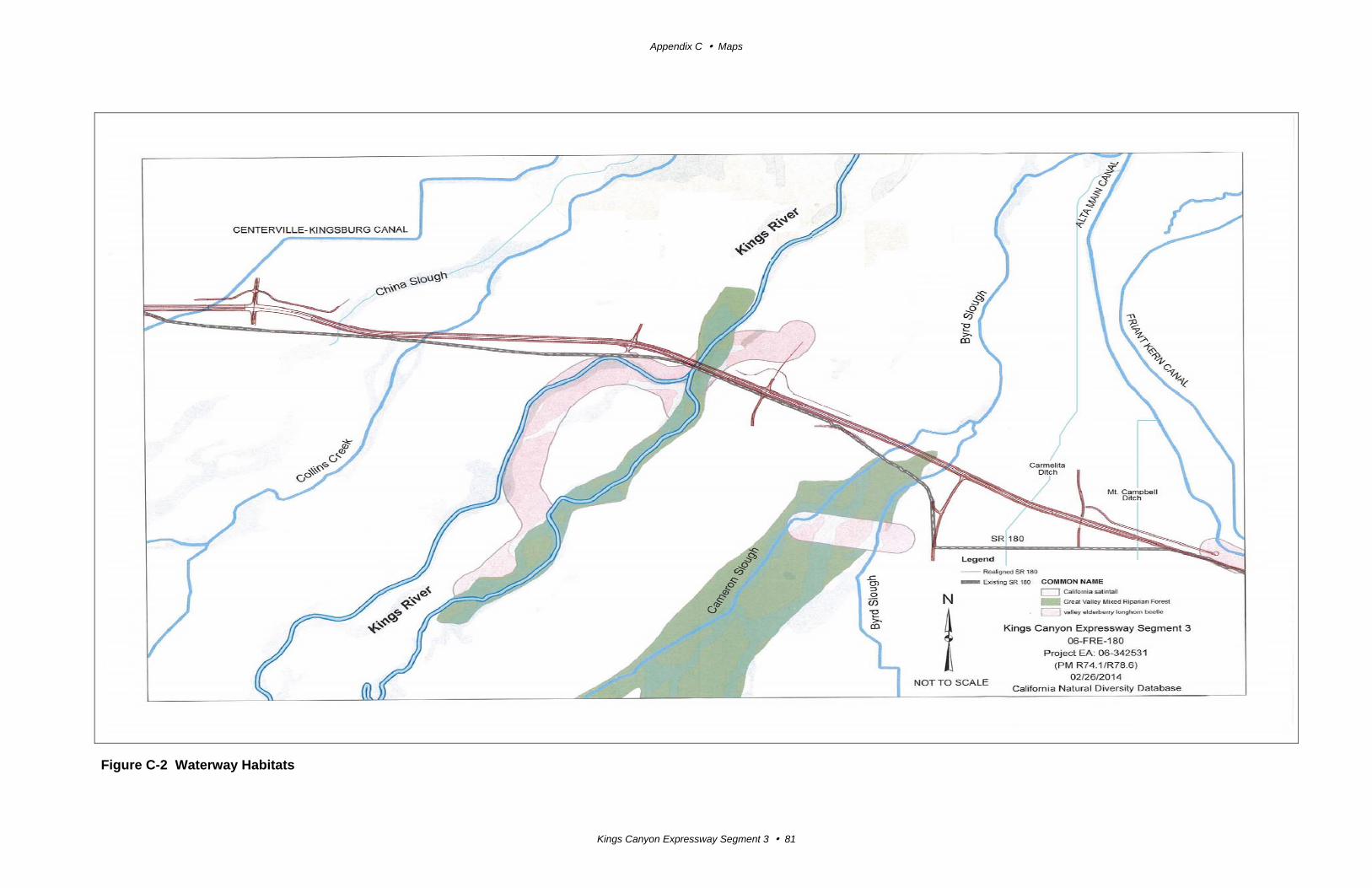
Appendix C Maps
Kings Canyon Expressway Segment 3 81
Figure C-2 Waterway Habitats

Kings Canyon Expressway Segment 3 83
Appendix D Comments and Responses
The Draft Supplement Environmental Impact Report for the Kings Canyon Expressway,
Segment 3 project was circulated for public review and comment from June 13, 2014 to
July 28, 2014.
Caltrans sent letters to federal, state, and local officials and to affected property owners
announcing the availability of the draft environmental document for public review and
comment. Copies of the environmental document were made available to the public at the
Sanger Branch Library, 1812 Seventh Street, Sanger, CA 93257 and the Caltrans District
6 office, 1352 W. Olive Avenue, Fresno, CA 93728.
The document was also accessible electronically at the Caltrans Internet website:
http://www.dot.ca.gov/dist6/factsheets/index.htm.
Comments received on the circulated draft document are provided in this appendix. No
written comments on the project were received from any federal agencies.
Several comments were received from the public, but none were written comments. One
email was sent to the Project Manager inquiring about the construction schedule for the
project and asked for information about bidding the construction contract. One non-profit
contacted the Environmental Branch Senior by telephone inquiring into whether their
organization will be used for mitigation. One property owner requested a public meeting
be held.
The comments in this appendix are organized as follows:
Section 1.0 State Agencies
Section 2.0 Local Agencies
Appendix D Comments and Responses
Kings Canyon Expressway Segment 3 84
Section 1.0 State Agencies
Comments from the State Clearinghouse, page 1 of 2
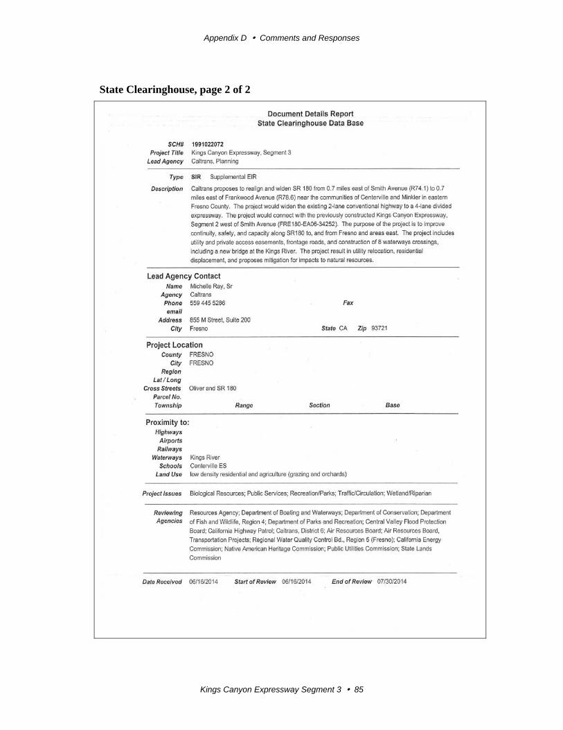
Appendix D Comments and Responses
Kings Canyon Expressway Segment 3 85
State Clearinghouse, page 2 of 2

Appendix D Comments and Responses
Kings Canyon Expressway Segment 3 86
Response to Comments from the State Clearinghouse
The State Clearinghouse letter acknowledges that Caltrans has completed the review
requirements for draft environmental documents as required in the California
Environmental Quality Act. It also requires Caltrans follow Section 21104 c) of the
California Public Resources Code. No response is necessary.
The State Clearinghouse received comment on the project from the Central Valley Flood
Protection Board, which was also submitted directly to Caltrans and is shown on the
following page.
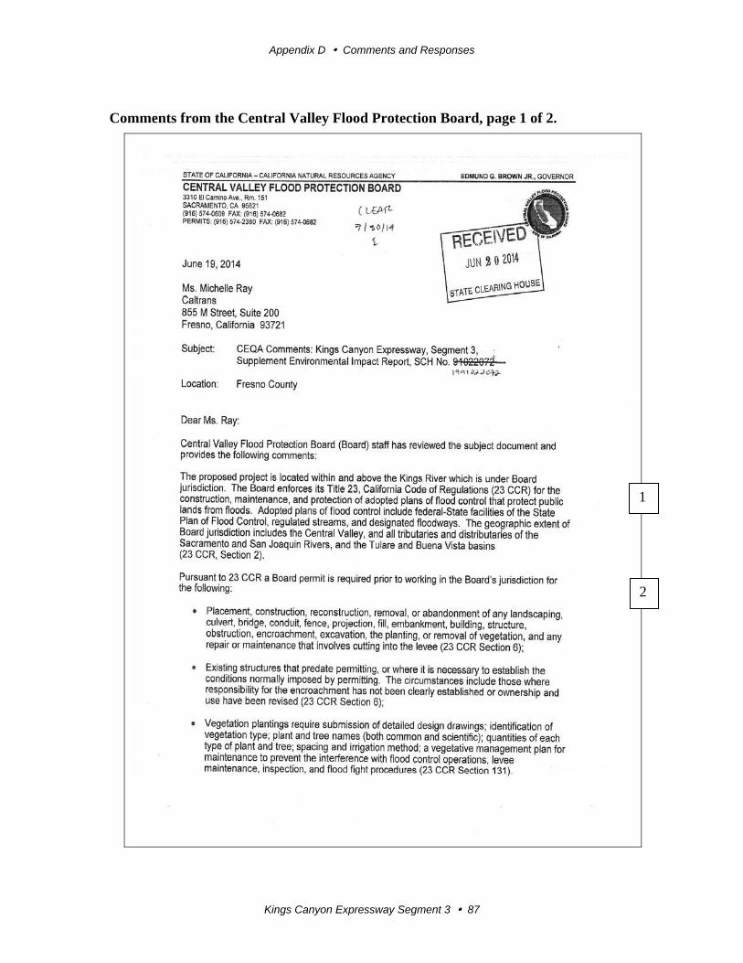
Appendix D Comments and Responses
Kings Canyon Expressway Segment 3 87
Comments from the Central Valley Flood Protection Board, page 1 of 2.
1
2
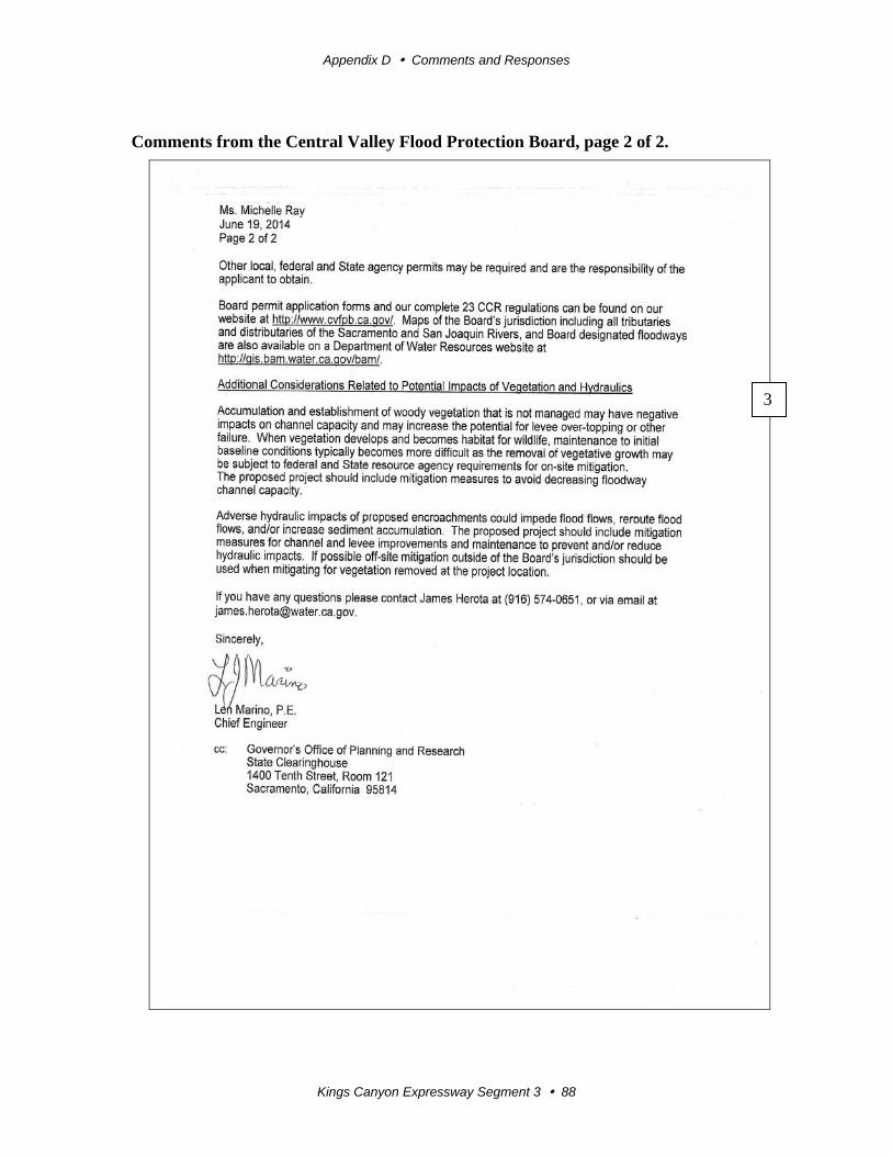
Appendix D Comments and Responses
Kings Canyon Expressway Segment 3 88
Comments from the Central Valley Flood Protection Board, page 2 of 2.
3
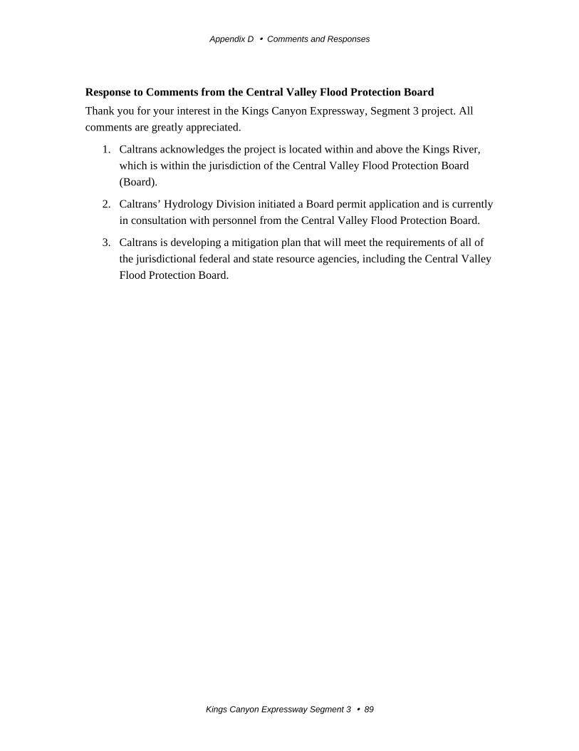
Appendix D Comments and Responses
Kings Canyon Expressway Segment 3 89
Response to Comments from the Central Valley Flood Protection Board
Thank you for your interest in the Kings Canyon Expressway, Segment 3 project. All
comments are greatly appreciated.
1. Caltrans acknowledges the project is located within and above the Kings River,
which is within the jurisdiction of the Central Valley Flood Protection Board
(Board).
2. Caltrans’ Hydrology Division initiated a Board permit application and is currently
in consultation with personnel from the Central Valley Flood Protection Board.
3. Caltrans is developing a mitigation plan that will meet the requirements of all of
the jurisdictional federal and state resource agencies, including the Central Valley
Flood Protection Board.
Appendix D Comments and Responses
Kings Canyon Expressway Segment 3 90
Comments from the Native American Heritage Commission, page 1 of 5
1
2
3
Appendix D Comments and Responses
Kings Canyon Expressway Segment 3 91
Comments from the Native American Heritage Commission, page 2 of 5
4
5
6
7
Appendix D Comments and Responses
Kings Canyon Expressway Segment 3 92
Comments from the Native American Heritage Commission, page 3 of 5
8
Appendix D Comments and Responses
Kings Canyon Expressway Segment 3 93
Comments from the Native American Heritage Commission, page 4 of 5
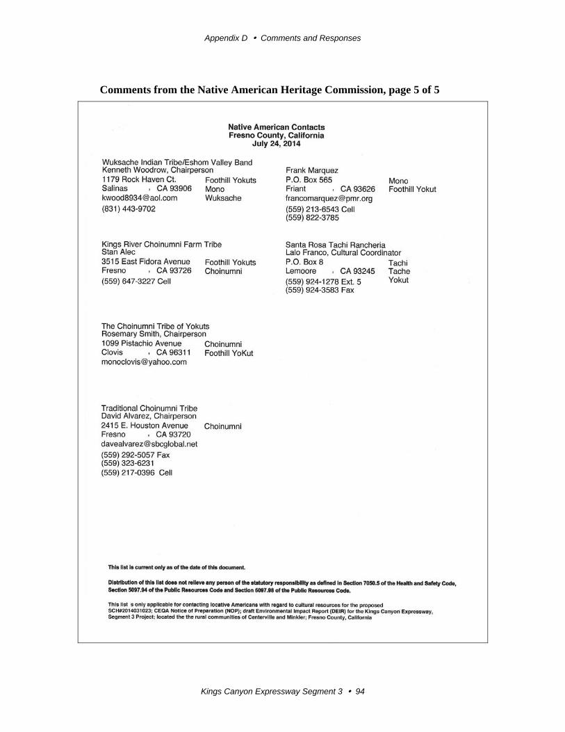
Appendix D Comments and Responses
Kings Canyon Expressway Segment 3 94
Comments from the Native American Heritage Commission, page 5 of 5
Appendix D Comments and Responses
Kings Canyon Expressway Segment 3 95
Response to Comments from the Native American Heritage Commission, page 1 of 2
Thank you for your interest in the Kings Canyon Expressway, Segment 3 project. All
comments are greatly appreciated.
1. Caltrans acknowledges the jurisdiction and special expertise held by the Native
American Heritage Commission.
2. Caltrans recognizes the sensitivity of the Kings River watershed to the Native
American tribes and has coordinated archaeological studies with the interested
tribes.
3. Caltrans’ mitigation plan will include provisions for the identification and
evaluation of accidentally discovered archaeological resources. During
construction, a certified archaeologist will monitor ground-disturbing activities in
areas identified archaeologically sensitive, as needed. Native American
monitoring is included in Caltrans’ mitigation plan.
4. The project includes federal funding, and the Section 106 process has been
applied throughout the development of the project and will continue throughout
construction.
5. Caltrans has completed its archaeological surveys. In addition to pedestrian
surveys, an Extended Phase I geo-archaeological investigation was conducted for
Segment 3 earlier this year to identify any archaeological resources. The Extended
Phase I investigation was coordinated with the local tribes showing interest in the
project, and Native American monitors were present. The report provided to
Caltrans concludes:
“No prehistoric archaeological materials were identified by this investigation and the likelihood of encountering prehistoric archaeological deposits in the project area is considered to be low. Based on the age, nature, and extent of the landscape changes documented by this study, the overall potential for buried prehistoric sites is far lower than expected because most formerly stable land surfaces were either removed, or prevented from forming, by the highly energetic channels that crossed this part of the Kings River fan. For these reasons, no further archaeological study, identification, or monitoring efforts are recommended for the project as it is currently defined and proposed.”
6. Native American contacts were provided by the Native American Heritage
Commission at the start of archaeological studies for the larger Kings Canyon
Expressway Project, Segments 1-3. Consultation with the tribes has been ongoing
for several years.
Appendix D Comments and Responses
Kings Canyon Expressway Segment 3 96
Response to Comments from the Native American Heritage Commission, page 2 of 2
7. No archaeological resources were discovered during the pedestrian surveys and
geo-archaeological testing done for the project; however, Caltrans included a
monitoring provision during construction.
8. Caltrans has included provisions for the discovery of Native American human
remains in our mitigation plans in case of accidental discovery.
Appendix D Comments and Responses
Kings Canyon Expressway Segment 3 97
Section 2.0 Local Agencies
Comments from the Sanger District Chamber of Commerce, page 1 of 4
1
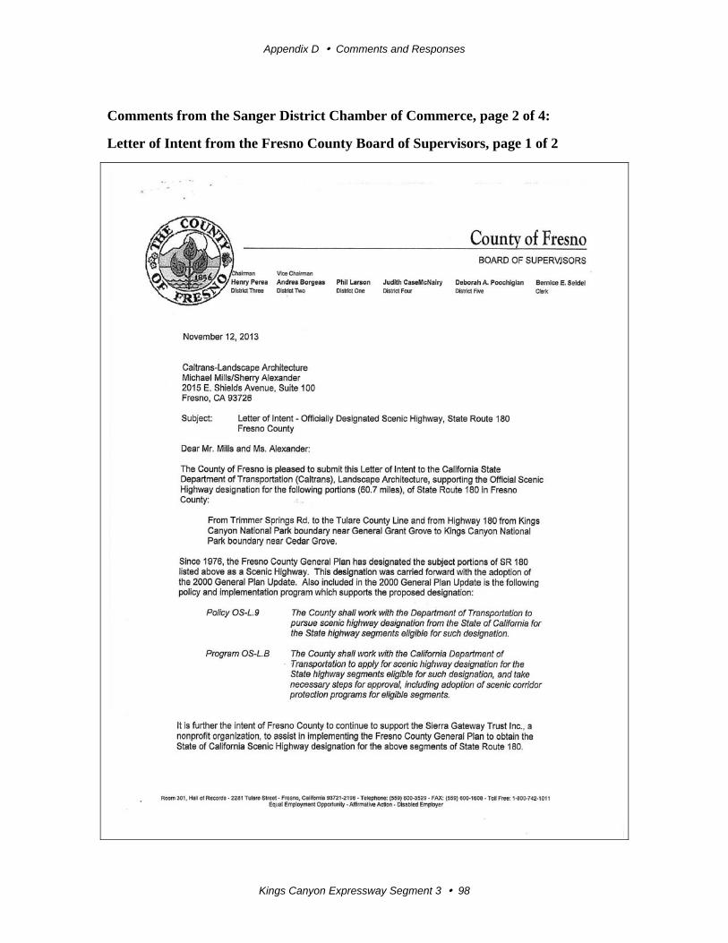
Appendix D Comments and Responses
Kings Canyon Expressway Segment 3 98
Comments from the Sanger District Chamber of Commerce, page 2 of 4:
Letter of Intent from the Fresno County Board of Supervisors, page 1 of 2
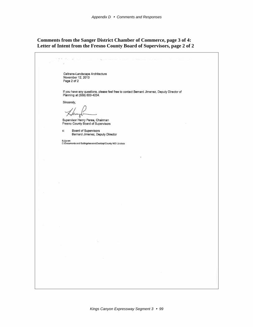
Appendix D Comments and Responses
Kings Canyon Expressway Segment 3 99
Comments from the Sanger District Chamber of Commerce, page 3 of 4: Letter of Intent from the Fresno County Board of Supervisors, page 2 of 2
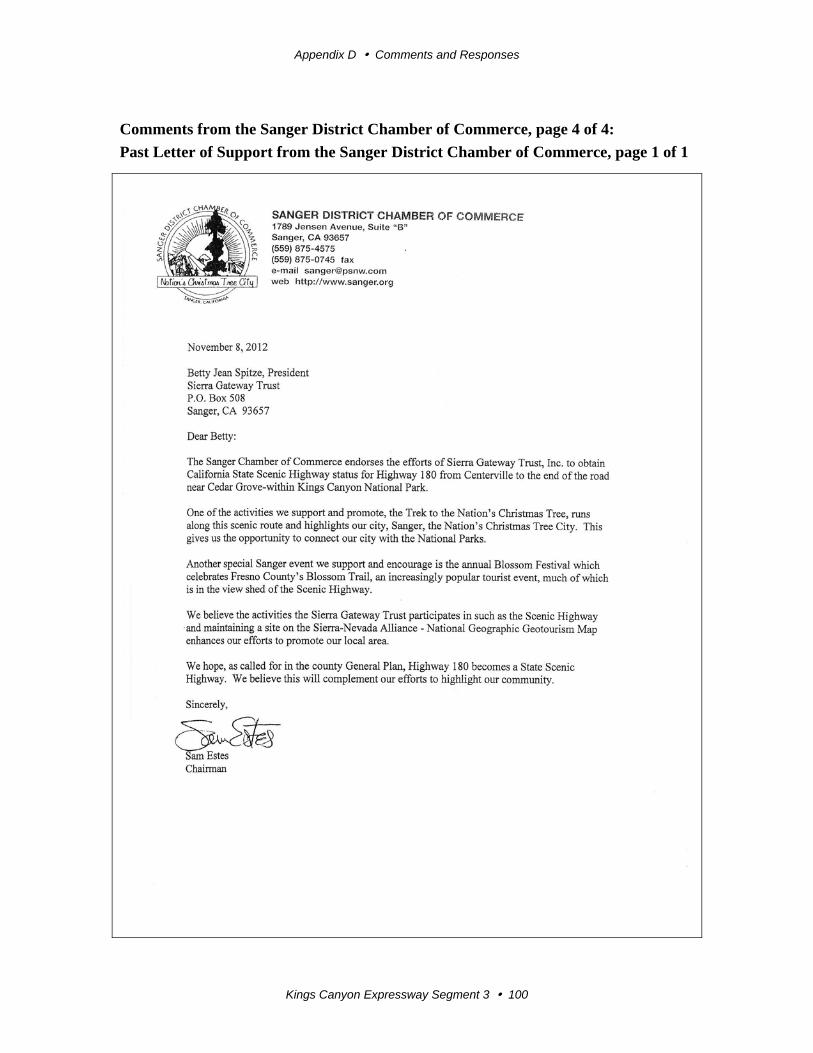
Appendix D Comments and Responses
Kings Canyon Expressway Segment 3 100
Comments from the Sanger District Chamber of Commerce, page 4 of 4:
Past Letter of Support from the Sanger District Chamber of Commerce, page 1 of 1
Appendix D Comments and Responses
Kings Canyon Expressway Segment 3 101
Response to Comments from the Sanger District Chamber of Commerce
Thank you for your interest in the Kings Canyon Expressway, Segment 3 project. All
comments are greatly appreciated.
1. The letters you submitted supporting the designation of State Route 180 as a
Scenic Highway were forwarded to the Caltrans District 6 Landscape Architecture
Division.
In 1976, the Fresno County General Plan designated two segments of State Route
180 in the eastern portion of the county as a Scenic Highway. The first segment is
from Trimmer Springs Road (post mile 74.95) to the Tulare County Line (Post
Mile 110.82), and the second segment is from the Kings Canyon National Park
boundary near General Grant Grove (post mile 112.09) to the Kings Canyon
National Park boundary near Cedar Grove (post mile 137.90). This designation
was carried forward with the adoption of the Fresno County 2000 General Plan
Update.
In 2008, the California State Legislature included in the State Scenic Highway
System (which includes Eligible and Officially Designated State Scenic Routes)
two parts of State Route 180: 1) from Route 65 near Minkler to the General Grant
Grove section of Kings Canyon National Park, and 2) the General Grant Grove
section of the Kings Canyon National Park boundary near Cedar Grove.
A Caltrans Landscape Architect has been working closely with the Sierra
Gateway Trust and the County of Fresno Planning and Development Division
during the process for obtaining Officially Designated State Scenic Highway
Status on the above-listed segments of State Route 180.
Most of the Kings Canyon Expressway, Segment 3 project falls within the area
proposed for Scenic Highway designation and will be included in the Scenic
Highway Management Plan required for Scenic Highway designation.
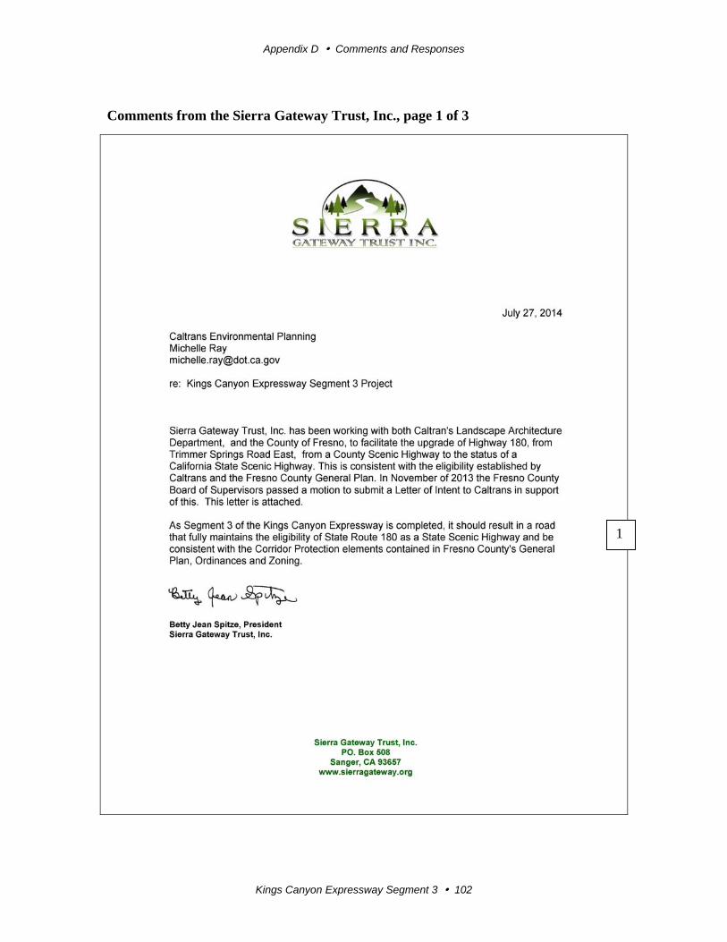
Appendix D Comments and Responses
Kings Canyon Expressway Segment 3 102
Comments from the Sierra Gateway Trust, Inc., page 1 of 3
1
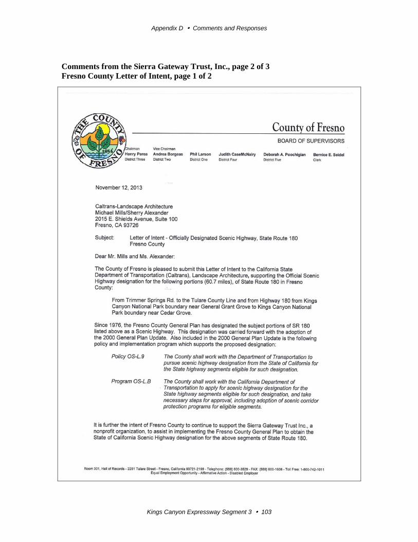
Appendix D Comments and Responses
Kings Canyon Expressway Segment 3 103
Comments from the Sierra Gateway Trust, Inc., page 2 of 3 Fresno County Letter of Intent, page 1 of 2
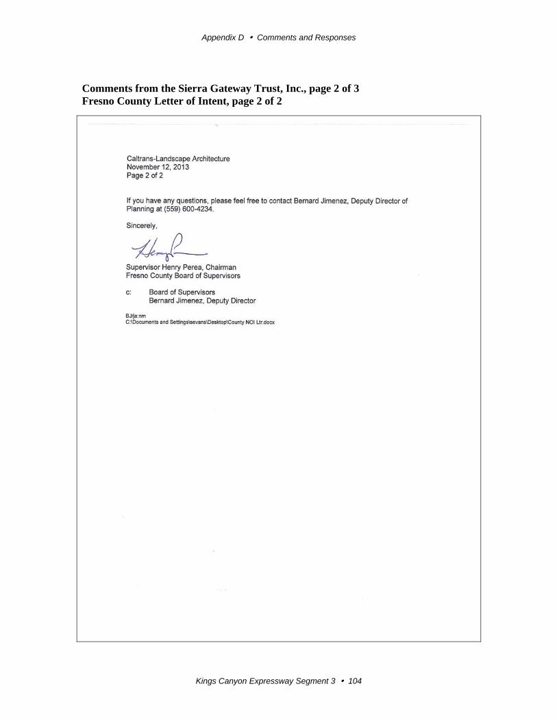
Appendix D Comments and Responses
Kings Canyon Expressway Segment 3 104
Comments from the Sierra Gateway Trust, Inc., page 2 of 3 Fresno County Letter of Intent, page 2 of 2
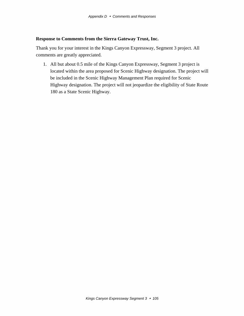
Appendix D Comments and Responses
Kings Canyon Expressway Segment 3 105
Response to Comments from the Sierra Gateway Trust, Inc.
Thank you for your interest in the Kings Canyon Expressway, Segment 3 project. All
comments are greatly appreciated.
1. All but about 0.5 mile of the Kings Canyon Expressway, Segment 3 project is
located within the area proposed for Scenic Highway designation. The project will
be included in the Scenic Highway Management Plan required for Scenic
Highway designation. The project will not jeopardize the eligibility of State Route
180 as a State Scenic Highway.