Embed Size (px)
Citation preview
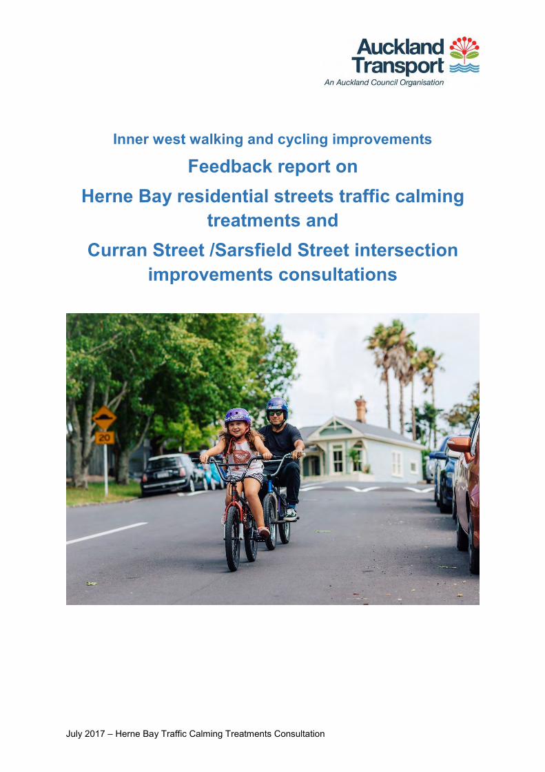
July 2017 – Herne Bay Traffic Calming Treatments Consultation
Inner west walking and cycling improvements
Feedback report on Herne Bay residential streets traffic calming
treatments and Curran Street /Sarsfield Street intersection
improvements consultations
July 2017 – Herne Bay Traffic Calming Treatments Consultation 1
Contents Summary ................................................................................................................... 3
Key themes in feedback ................................................................................................... 3
Outcome ........................................................................................................................... 3
Next steps ........................................................................................................................ 4
Background .............................................................................................................. 5
Project information............................................................................................................ 5
Previous public feedback .................................................................................................. 5
Proposed improvements ................................................................................................... 5
Consultation ............................................................................................................. 7
Activities to raise awareness ............................................................................................ 7
Giving feedback ................................................................................................................ 7
Your feedback .......................................................................................................... 8
Overall support for traffic calming in Herne Bay ................................................................ 9
Themes in comments on proposal .................................................................................. 10
General sentiment ...................................................................................................... 11
Treatment location ..................................................................................................... 12
Treatment design ....................................................................................................... 13
Alternative treatments ................................................................................................ 14
Cycling ....................................................................................................................... 15
Parking ...................................................................................................................... 16
Aesthetics .................................................................................................................. 17
Behavioural and other ................................................................................................ 18
Other submissions ................................................................................................. 19
Herne Bay Residents’ Association .................................................................................. 19
Waitematā Local Board .................................................................................................. 20
Attachment 1: Types of traffic calming treatments proposed ............................ 25
Attachment 2: Feedback form ............................................................................... 27
Attachment 3: Key themes and submitter comments with AT responses ........ 28
Attachment 4: Feedback on Curran and Sarsfield St intersection proposal ... 52
Summary ................................................................................................................. 53
Key themes in feedback ................................................................................................. 53
Outcome ......................................................................................................................... 53
Next steps ...................................................................................................................... 53
July 2017 – Herne Bay Traffic Calming Treatments Consultation 2
Background ............................................................................................................ 54
Project information.......................................................................................................... 54
Previous public feedback ................................................................................................ 54
Proposed improvements ................................................................................................. 54
Consultation ........................................................................................................... 56
Activities to raise awareness .......................................................................................... 56
Giving feedback .............................................................................................................. 56
Your feedback ........................................................................................................ 57
Themes in comments on proposal .................................................................................. 57
Aspects of the proposed design that you liked ................................................................ 58
Aspects of the design you would change and why ..................................................... 60
Curran Street traffic calming suggestions ................................................................... 61
Other comments or concerns ..................................................................................... 65
Appendix 1: Proposed design - Curran/Sarsfield St intersection ...................... 67
Appendix 2: Feedback form .................................................................................. 68
Appendix 3: Key themes and submitter comments with AT responses ........... 69
July 2017 – Herne Bay Traffic Calming Treatments Consultation 3
Summary Key themes in feedback
471 people submitted feedback on the Herne Bay traffic calming treatments proposal. Thank you for your feedback, your time and effort is greatly appreciated.
We have identified these major themes in your feedback:
High level of support (69%) for traffic calming in the Herne Bay area
Good support for proposal (59% generally like proposed treatments)
Concern that road narrowing at treatments will create congestion and reduce cyclist safety (17%)
Concern that parking removal at mid-block treatments will exacerbate existing parking availability issues (17%)
Suggestions to extend the treatment area to include surrounding streets (14%).
Outcome We have used your feedback to help us finalise the location and design of the proposed treatments. As a result, we have decided to:
Install a total of 22 traffic calming treatments (speed tables) at the locations proposed. All speed tables will require road narrowing with planted kerb build-outs. There will be a pedestrian crossing facility at all speed tables except for mid-block speed tables. Please refer to Figure 1 for location map and type of speed tables
Widen mid-block speed tables (9 locations) to 6m (from the proposed 4.5m) to allow two-way traffic through the speed table
Put an additional boundary speed table at the intersection of Clifton Road and Jervois Road (close to Bayfield School)
Remove two on-street parking spaces at each mid-block speed table (9 locations). Additional parking removal may be required close to mid-block speed tables to meet sightline requirements for motorists.
The following changes are to be made to the Curran Street/Sarsfield Street intersection:
o Install new speed tables on Sarsfield Street, either side of its junction with Curran Street, to calm traffic and signal to drivers that they are entering a lower speed environment. Speed tables will have provision for a pedestrian crossing.
July 2017 – Herne Bay Traffic Calming Treatments Consultation 4
o Install a new shared path at the north-western corner of the Curran Street and Sarsfield Street intersection to provide a better connection to the existing shared path further north on Curran Street.
o Install new pedestrian refuge islands on Curran Street, located to the north and south of the Sarsfield Street intersection.
o Remove the right-turn bay on Curran Street into Sarsfield Street East to accommodate the refuge islands
o Investigate installing pedestrian handrail barriers on both Curran Street pedestrian refuges.
Next steps Construction is planned to commence in late 2017 and to be completed by June 2018. We will notify all directly affected people about any changes that develop in the detailed design phase of this project.
July 2017 – Herne Bay Traffic Calming Treatments Consultation 5
Background Project information Auckland Transport (AT) is proposing improvements in the Herne Bay area as part of a wider cycling network from Point Chevalier to the city fringe.
The Herne Bay area has many local community facilities such as nearby beaches, parks, shops, cafes, schools and sports clubs. However, traffic surveys show high traffic volumes and speeds on roads in the area, and residents have concerns about speeding and ‘rat running' (using residential side streets instead of main roads).
We want to address community traffic issues, enhance the look and feel of the Herne Bay area, and improve routes for local people walking or cycling to their local shops, beaches and cafes, or to get to work and attractions in the city centre.
Previous public feedback In March last year, we asked for your feedback on a proposed network of cycling routes in the wider area and received strong community support. We also heard concerns from the Herne Bay Residents’ Association about speeding and 'rat running' in the Herne Bay area.
Initially, the preferred option was to provide a connection for people on bikes via Clifton Road, Argyle Street and Sarsfield Street. However, taking feedback from this consultation on board, we have investigated implementing traffic calming treatments on several streets rather than a cycle lane on a particular street.
Proposed improvements We aim to create a slower speed environment in Herne Bay residential streets so people on bikes and motorists can share the road safely. This will also create a safer and more enjoyable environment for other vulnerable road users, such as pedestrians and children.
Physical measures to reduce traffic speed are preferred over reduced speed limits because they don’t require speed camera or police enforcement to be effective.
We proposed four types of traffic calming treatments that will:
Narrow the road width by using planted raised islands to extend the kerb
Create a speed table by raising the section of road between the kerb build-outs.
July 2017 – Herne Bay Traffic Calming Treatments Consultation 6
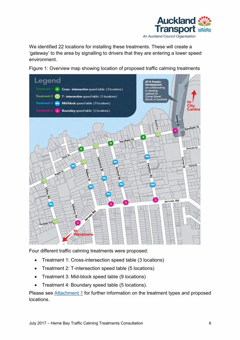
We identified 22 locations for installing these treatments. These will create a ‘gateway’ to the area by signalling to drivers that they are entering a lower speed environment.
Figure 1: Overview map showing location of proposed traffic calming treatments
Four different traffic calming treatments were proposed:
Treatment 1: Cross-intersection speed table (3 locations)
Treatment 2: T-intersection speed table (5 locations)
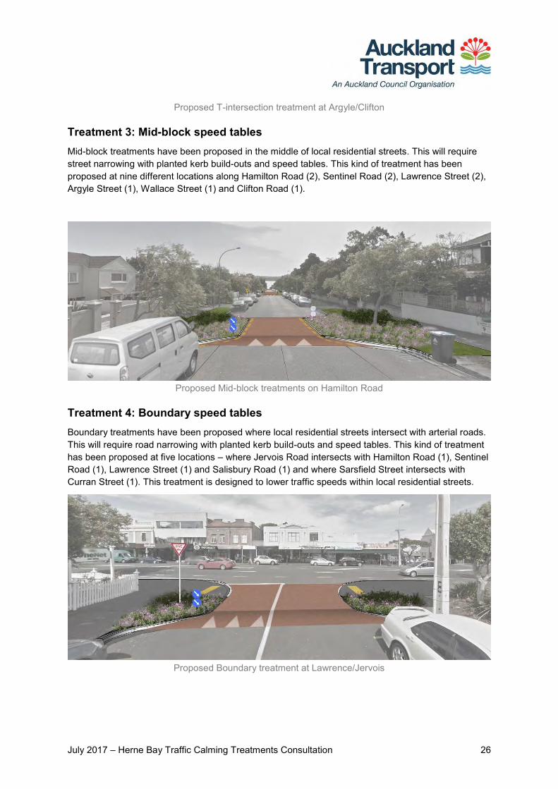
Treatment 3: Mid-block speed table (9 locations)
Treatment 4: Boundary speed table (5 locations). Please see Attachment 1 for further information on the treatment types and proposed locations.
July 2017 – Herne Bay Traffic Calming Treatments Consultation 7
Consultation We consulted on the proposed treatments from 23 November to 18 December 2016.
Activities to raise awareness To let you know about our consultation, we:
Mailed consultation letters and feedback forms to 3062 property owners and occupiers throughout Herne Bay. Additional copies were provided to the Herne Bay Residents Association and the Ley Institute Ponsonby Library
Hand-delivered consultation letters and feedback forms to all businesses along Jervois Road and all properties on the streets along which treatments are proposed. Emmett Street, Tweed Street and Shelly Beach Road were also included on request
Emailed the consultation letter to the Waitematā Local Board, Herne Bay Residents Association, St Mary’s Bay Association, Bike Auckland, Transport Blog, Generation Zero, Bayfield School and Ponsonby Primary school
Set up a project webpage and an online feedback form on our website
Placed an advertisement in the Auckland City Harbour newspaper on 30 November 2016
Distributed a media release on 24 November 2016 and published articles in Auckland City Harbour News and on the Bike Auckland website
Posted information on Facebook through the Waitematā Local Board and Auckland Council pages, as well as on Neighbourly, Twitter and LinkedIn
Held two open days (as advertised in the letter) to provide information about our proposals; at The Governor café, 228 Jervois Road on Thursday 1 December and at the Leys Institute Ponsonby Library, 20 St Marys Road, on Saturday 10 December.
Additional consultation was carried out for the proposed Curran and Sarfield Street intersection improvements from 13 April to 14 May 2017 to address concerns raised in this consultation. Please see Attachment 4 of this report for the consultation feedback analysis for this proposal.
Giving feedback We asked you whether you supported traffic calming in the Herne Bay area, what aspects of the proposed traffic calming treatments you liked and those you would change, and why. We also asked if you had any other comments on the proposal.
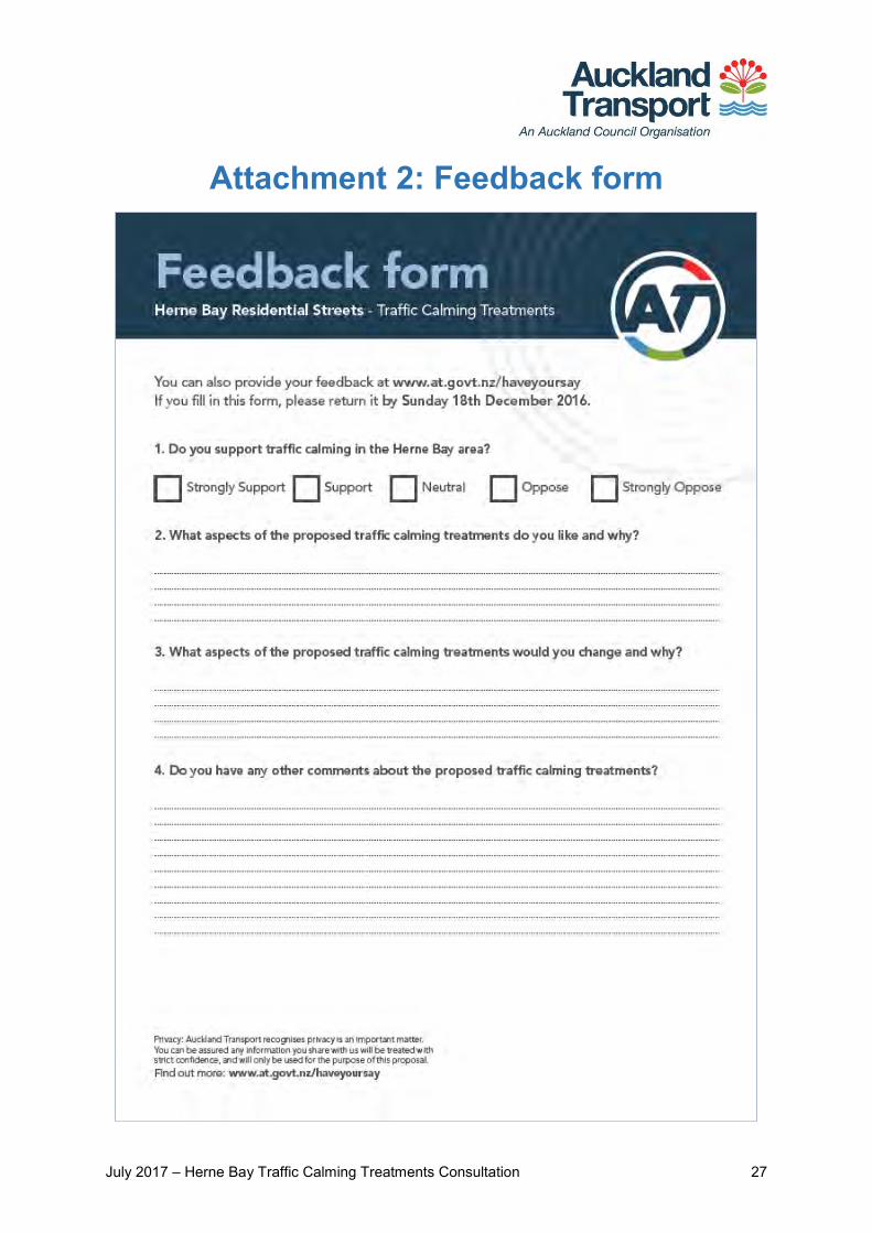
You could provide feedback using an online submission form (on our Have Your Say website) or a hard copy form that we posted or handed out to interested parties. See Attachment 2 at the end of this report for a copy of the feedback form.

July 2017 – Herne Bay Traffic Calming Treatments Consultation 8
Your feedback We received public feedback on the proposal from 471 submitters:
196 of these were submitted online and 275 were submitted using the hardcopy feedback form
380 submitters provided an address. Of these, 318 live in Herne Bay and 62 live elsewhere in Auckland.
Base of N=471.
The Waitematā Local Board and the Herne Bay Residents’ Association also submitted as part of this consultation. These are addressed in the ‘Other submissions’ section.
We also received 4 emails, 6 phone calls and spoke with 25 local residents and business owners at the two open days. Feedback from these sources was considered separately.
Please see Attachment 3 for AT responses to the themes and design suggestions.
50
16
209
41
46
109
0 50 100 150 200 250 300 350
Not provided
Not Herne Bay
Herne Bay
Number of submitters
Sub
mit
ter
add
ress
Submitter address and type of feedback
Hard copyOnline
July 2017 – Herne Bay Traffic Calming Treatments Consultation 9
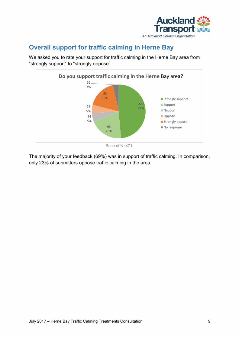
Overall support for traffic calming in Herne Bay We asked you to rate your support for traffic calming in the Herne Bay area from “strongly support” to “strongly oppose”.
Base of N=471.
The majority of your feedback (69%) was in support of traffic calming. In comparison, only 23% of submitters oppose traffic calming in the area.
22949%
9520%
245%
245%
8318%
163%
Do you support traffic calming in the Herne Bay area?
Strongly support
Support
Neutral
Oppose
Strongly oppose
No response
July 2017 – Herne Bay Traffic Calming Treatments Consultation 10
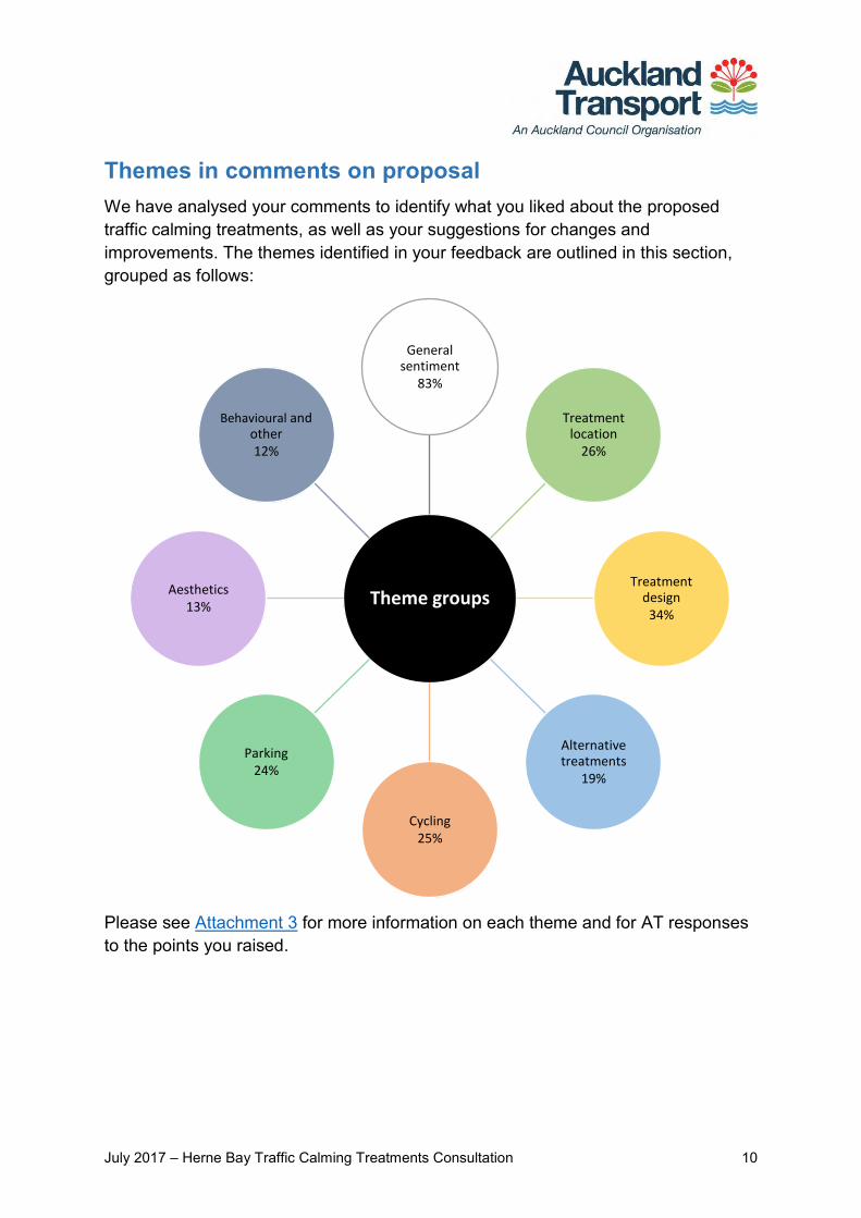
Themes in comments on proposal We have analysed your comments to identify what you liked about the proposed traffic calming treatments, as well as your suggestions for changes and improvements. The themes identified in your feedback are outlined in this section, grouped as follows:
Please see Attachment 3 for more information on each theme and for AT responses to the points you raised.
Theme groups
General sentiment
83%
Treatment location
26%
Treatment design
34%
Alternative treatments
19%
Cycling25%
Parking24%
Aesthetics13%
Behavioural and other12%
July 2017 – Herne Bay Traffic Calming Treatments Consultation 11
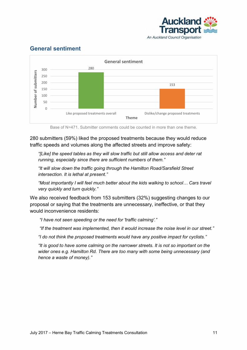
General sentiment
Base of N=471. Submitter comments could be counted in more than one theme.
280 submitters (59%) liked the proposed treatments because they would reduce traffic speeds and volumes along the affected streets and improve safety:
“[Like] the speed tables as they will slow traffic but still allow access and deter rat running, especially since there are sufficient numbers of them.”
“It will slow down the traffic going through the Hamilton Road/Sarsfield Street intersection. It is lethal at present.”
“Most importantly I will feel much better about the kids walking to school… Cars travel very quickly and turn quickly.”
We also received feedback from 153 submitters (32%) suggesting changes to our proposal or saying that the treatments are unnecessary, ineffective, or that they would inconvenience residents:
“I have not seen speeding or the need for 'traffic calming'.”
“If the treatment was implemented, then it would increase the noise level in our street.”
“I do not think the proposed treatments would have any positive impact for cyclists.”
“It is good to have some calming on the narrower streets. It is not so important on the wider ones e.g. Hamilton Rd. There are too many with some being unnecessary (and hence a waste of money).”
280
153
0
50
100
150
200
250
300
Like proposed treatments overall Dislike/change proposed treatments
Nu
mb
er
of
sub
mit
ters
Theme
General sentiment
July 2017 – Herne Bay Traffic Calming Treatments Consultation 12
Treatment location
Base of N=471.Submitter comments could be counted in more than one theme.
Many people requested that the treatment area be extended to other parts of Herne Bay:
“You should include Masons Ave, the average speed is very high at present, and it's the main short-cut road from Cox's Bay to the bridge.”
“Some sort of calming treatment needs to be implemented on Curran Street, especially in front of the school.”
“I would like to see the continuation of traffic control and speed adjacent to Pt Erin Park + pools. Sarsfield Street East has become a "race track" for traffic exiting SH1 on Shelly Beach Road.”
Or that additional treatments be installed within the proposed area:
“Add treatments to Cremorne and Stack Streets as quite a lot of traffic goes through there at speed.”
“I'm not sure one mid-block on Clifton Road is enough. If Sentinel and Hamilton require two then surely Clifton and also Mason Ave does.”
67
35
17 17 16
0
10
20
30
40
50
60
70
80
Extend treatmentarea
Add extra treatment(in area)
Relocate a treatment Traffic spill-overconcerns
Curran/Sarsfieldintersection
Nu
mb
er
of
sub
mit
ters
Theme
Treatment location
July 2017 – Herne Bay Traffic Calming Treatments Consultation 13
Treatment design
Base of N=471.Submitter comments could be counted in more than one theme.
Road narrowing through the treatments was a concern for many:
“Creates a competition for space on the table between cyclist and car.”
“Leaving the side streets and turning on to Jervois Road will create a bottleneck if restricted to one lane. Traffic turning right is often delayed and if not able to slip in and turn left [this] will be an issue.”
Suggested changes to the proposed midblock treatments include removing those proposed along Lawrence, Sentinel or Hamilton Roads, making them two-way, or not installing any at all:
“I think it is overkill down Hamilton Road. I didn't think the traffic was that hectic to warrant so many speed tables.”
“Widen midblock speed tables to allow cars from both directions to cross together - reduce braking + clogging up road.”
Boundary treatments were requested by some submitters to be placed further away from the intersection or made wide enough for three lanes (two exiting, one entering side street):
“The treatment 4 Boundary speed table is extremely unsafe as it requires vehicles to virtually stop while crossing Jervois Rd when turning right across traffic to access Sentinel Rd. The speed table could be moved one car length into Sentinel road to minimise this problem. This was a problem with the existing speed table before re-asphalting reduced the height difference between the two surfaces.”
80
48
28 2822
10
0
10
20
30
40
50
60
70
80
90
Road narrowingconcerns
Change Mid-block treatments
ChangeBoundary
treatments
Change Cross-/T-/all treatments
Speed tableheight or length
concerns
Visibilityconcerns
Nu
mb
er
of
sub
mit
ters
Theme
Treatment design
July 2017 – Herne Bay Traffic Calming Treatments Consultation 14
“I would remove the boundary speed tables at the top of each street where it intersects with Jervois Road… the narrow width of these would create a traffic jam as cars turning left would have to wait for cars turning right to clear.”
Other suggested changes were removal of treatments along particular streets:
“Treatment 1 should not proceed. Sarsfield is a key arterial road for Herne Bay residents to get to and from the bridge.”
“I don't see the point of the calming Treatment 4 for Saratoga Ave or Salisbury Ave (or Masefield Ave) which are all dead end streets.”
Submitters suggested variable changes to speed table heights and lengths:
“Speed tables need to be high enough to ensure car speeds actually reduce.”
“Platforms [should] have a gradient that achieves the objective of slowing traffic without making it a health hazard for people with spinal problems.”
“Important that speed tables are not so abrupt that residents with a speed table in front of their houses suffer excessive noise.”
“I propose the mid-block speed tables be very short, so that we lose no parking spaces.”
Alternative treatments
Base of N=471.Submitter comments could be counted in more than one theme.
Many submitters suggested a speed limit instead of, or in combination with, the proposed traffic calming treatments:
“If you want people to travel at 30kph or 40kph, simple, post that as limit. Lower it first. You are saying it is a problem but people are simply travelling at the speed limit.”
“Introduce a 30 km/h formal speed limit for this area, to reinforce expectations.”
“I would like to see a 40kph zone in Jervois Road.”
4540
23
0
10
20
30
40
50
Lower speed limit Suggest alternative treatments Other treatment design concerns
Nu
mb
er
of
sub
mit
ters
Theme
Alternative/additional treatments
July 2017 – Herne Bay Traffic Calming Treatments Consultation 15
Other alternative treatments proposed included chicanes, speed humps, road closures, and increased enforcement:
“Only use chicanes - better for car suspension, still slow traffic, less vehicle noise for residents.”
“Bump in centre but leave spaces for parking.”
“A diagonal diverter [should] be installed at the intersection of Sarsfield & Hamilton ensuring that none of the local streets in Herne Bay can be used as a short cut by motor vehicles to get to or from the bridge.”
“A police car and camera would do more.”
Respondents also suggested a range of additional and other improvements to the proposed treatment area:
“I would like to draw your attention to the STOP sign at the corner of Stack and Cremorne street. Many drivers do not come to a full stop.”
“Add pedestrian crossings at the intersections that are being modified.”
“Please remove the white lines on Sarsfield Street, to reduce the ‘race track’ effect.”
Cycling
Base of N=471. Submitter comments could be counted in more than one theme.
Many submitters suggested installing dedicated cycleways instead of, or in addition to, the proposed traffic calming treatments:
“Spend the money on separated cycle lanes instead.”
“I think that there should be bicycle lanes painted onto the road, too.”
Bike bypasses through the proposed treatments were also requested by several:
45
26 26 25
7
26
0
10
20
30
40
50
Suggestdedicatedcycleways
Suggest bikebypasses through
treatments
Won't improvecycling
Other cyclingsuggestions
Will improvecycling
Improve cyclingin other areas
Nu
mb
er
of
sub
mit
ters
Theme
Cycling
July 2017 – Herne Bay Traffic Calming Treatments Consultation 16
“[Suggest] bike bypasses for the midblock speed tables so cars slow but bikes don't need to share the narrow space with them.”
Some felt that the proposal would not make cycling in the area easier or safer:
“I fail to see how the introduction of the proposed “traffic calming treatments” in all the side-streets of Herne Bay is going to substitute for the dedicated cycle way or benefit the cycling commuters in any way.
Or made other suggestions about how cycling in the area could be improved:
“Masons Ave [is] wider and safer than Clifton Road for cycles.”
“I'd like to see some signage added indicating that this is a safe cycle route.”
We also received several suggestions to install cycling facilities in neighbouring areas:
“Put a cycleway up Shelly Beach Road - it's very dangerous riding up there and it's the simplest way to come up from Westhaven.”
“I think Curran St should be a candidate for a protected cycle lane on the western side of the road.”
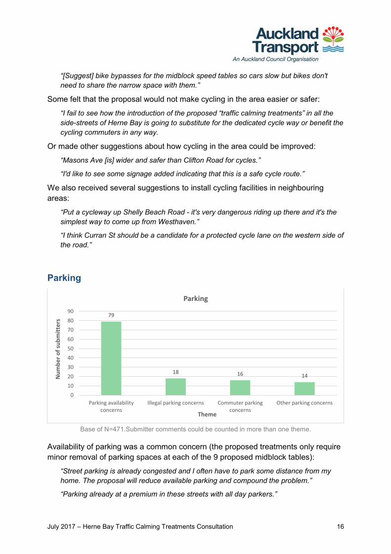
Parking
Base of N=471.Submitter comments could be counted in more than one theme.
Availability of parking was a common concern (the proposed treatments only require minor removal of parking spaces at each of the 9 proposed midblock tables):
“Street parking is already congested and I often have to park some distance from my home. The proposal will reduce available parking and compound the problem.”
“Parking already at a premium in these streets with all day parkers.”
79
18 16 14
0
10
20
30
40
50
60
70
80
90
Parking availabilityconcerns
Illegal parking concerns Commuter parkingconcerns
Other parking concerns
Nu
mb
er
of
sub
mit
ters
Theme
Parking
July 2017 – Herne Bay Traffic Calming Treatments Consultation 17
Illegal or dangerous parking, for example close to intersections and driveways, was also identified as a problem in the area:
“[Like] the T-intersection speed table at junction of Wallace St and Argyle St - at present due to cars parked close to the intersection, visibility is limited when turning.”
“I would put in more and yellow lines indicating no parking around driveways near Herne Bay beach as our drive is constantly being parked over.”
Several submitters also expressed concern about commuter parking, suggesting that time restrictions or a residential parking zone be introduced:
“Introduce 'Residents Parking' to Herne Bay… non-residents are parking all day (catching the bus into CBD) causing parking congestion for residents.”
“If the mid-block speed tables are considered appropriate then time limited parking is also appropriate in Hamilton Road. It is currently a day park area for people working in and around Auckland.”
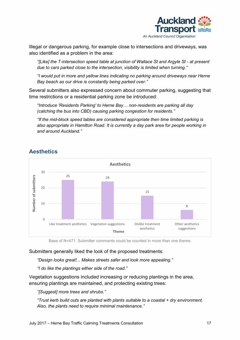
Aesthetics
Base of N=471. Submitter comments could be counted in more than one theme.
Submitters generally liked the look of the proposed treatments:
“Design looks great!... Makes streets safer and look more appealing.”
“I do like the plantings either side of the road.”
Vegetation suggestions included increasing or reducing plantings in the area, ensuring plantings are maintained, and protecting existing trees:
“[Suggest] more trees and shrubs.”
“Trust kerb build outs are planted with plants suitable to a coastal + dry environment. Also, the plants need to require minimal maintenance.”
25 24
15
6
0
10
20
30
Like treatment aesthetics Vegetation suggestions Dislike treatmentaesthetics
Other aestheticssuggestions
Nu
mb
er
of
sub
mit
ters
Theme
Aesthetics
July 2017 – Herne Bay Traffic Calming Treatments Consultation 18
“The number of features along Sarsfield when combined with existing planting features seems excessive.”
A few people found the proposed treatments and/or plantings unattractive:
“The speed tables are very ugly and will spoil the look of the street.”
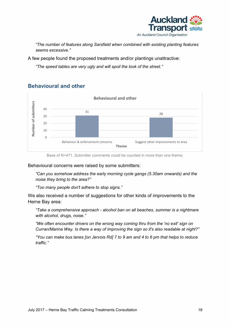
Behavioural and other
Base of N=471. Submitter comments could be counted in more than one theme.
Behavioural concerns were raised by some submitters:
“Can you somehow address the early morning cycle gangs (5.30am onwards) and the noise they bring to the area?”
“Too many people don't adhere to stop signs.”
We also received a number of suggestions for other kinds of improvements to the Herne Bay area:
“Take a comprehensive approach - alcohol ban on all beaches, summer is a nightmare with alcohol, drugs, noise.”
“We often encounter drivers on the wrong way coming thru from the 'no exit' sign on Curran/Marina Way. Is there a way of improving the sign so it's also readable at night?”
“You can make bus lanes [on Jervois Rd] 7 to 9 am and 4 to 6 pm that helps to reduce traffic.”
3128
0
10
20
30
40
Behaviour & enforcement concerns Suggest other improvements to area
Nu
mb
er
of
sub
mit
ters
Theme
Behavioural and other

July 2017 – Herne Bay Traffic Calming Treatments Consultation 19
Other submissions In addition to the public feedback we received through our submission forms, we also received submissions from key interest groups. Feedback from the Herne Bay Residents’ Association and the Waitematā Local Board is summarised below. Concerns and suggestions raised by these groups have been responded to separately.
Herne Bay Residents’ Association The Herne Bay Residents’ Association Incorporated (HBRAI) provided feedback on the proposal in a letter to AT. In general, they support the proposed traffic calming, but had some reservations. These are summarised below.
Traffic displacement concerns
Insufficient investigation of traffic displacement caused by proposal, particularly to Curran Street; also Shelly Beach Road, Emmett and Tweed Streets
Curran Street cannot carry any more traffic and should not be designated as a regional arterial road. Traffic calming and greater priority for pedestrians and cyclists should be implemented
Requests traffic engineering assessment and mitigation plan. Curran Street north of Sarsfield Street
AT should have full jurisdiction over this section of road
Request to be included in discussions between AT and Panuku Development Auckland.
Consultation concerns
Feedback from Herne Bay residents and businesses won’t be given enough weight. Jervois Road businesses have a particular interest in on-street parking which should be considered
The consultation was held at a busy time of year, preventing sufficient consideration of the proposal. Further, collaborative engagement with local residents and businesses should be carried out.
Auckland Transport had several discussions and meetings with HBRAI post public consultation to listen to and address their concerns. We have addressed them through further traffic modelling and traffic impact assessment with a focus on Jervois Rd and Curran St. An independent peer review on the traffic impact assessment was completed in June 2017.
July 2017 – Herne Bay Traffic Calming Treatments Consultation 20
A meeting was held on 15 June 2017 with HBRAI, the project consultant and the independent peer reviewer to clarify the results of the traffic impact assessment report, to close out HBRAI’s concerns.
The traffic impact assessment report confirmed that diverting “rat running” traffic from residential streets to the adjacent arterial streets (Jervois Rd and Curran St) is unlikely to result in any significant change in performance of the signalised intersection at Jervois Rd/Curran St or impact on traffic volumes in Curran Street. The independent peer review report also stated that it is reasonable to assume that the road network will operate similarly to that experienced today, once the project has been completed.
We would like to thank Herne Bay Residents’ Association for taking the time to provide feedback on this project.
Waitematā Local Board The Waitematā Local Board (WLB) provided feedback via email. Feedback is as follows:
The Board supports the completion of the Auckland Cycle Network including the Urban Cycle Investment funded route from Westhaven (City Centre) to Pt Chev via Herne Bay. This route includes sections of the Board’s greenways route that was consulted on in 2012.
The Board notes that Auckland Transport is proposing to take a traffic management zone approach to the cycling improvements (rather than one route with a separated cycle path that would have had a major impact on residential parking) and notes the broad public support for a zonal approach that aims to reduce speeds and vehicle volumes to provide for safe cycling and walking in a number of neighbourhood streets as well as improve local amenity and the street environment.
The Board provides the following feedback on the proposed improvements:
The final design of the traffic calming measures (treatments) must result in reduced speeds and vehicle volumes to create a safe street environment for 8-80 year olds cycling.
The treatments must be designed to enhance neighbourhood amenity and
improve the walking environment through additional planting and traffic calming
Further road safety improvements are supported around Bayfield School to
reduce speeds and provide a safe crossing point at the Clifton Road/Jervois Road intersection. A treatment should be included in this location
July 2017 – Herne Bay Traffic Calming Treatments Consultation 21
Further traffic calming on Curran Street is supported to reduce high speeds
near Ponsonby Primary School Safety improvements are supported at the Jervois Street/Curran Street
intersection to address the concerns raised by the Herne Bay Residents Association
The Board would like to have input into the proposed Sarsfield Street/Curran
Street intersection design and notes that the local community has been advocating for safer crossing points and reduced speeds in this location for some time
The board requests that the greenway route through Salisbury Street and
Salisbury Reserve is incorporated into the project with shared path enhancements and entry and exits from Salisbury Street and Argyle Street
The Board requests that water sensitive design is incorporated into planting at
intersections to reduce storm water overflow. Water sensitive design is a recommended design element in the Local Paths (greenways) Design Guide During heavy rain events storm water in this area mixes with contaminated waste and discharges onto our beaches and waterways. The Council’s Healthy Waters team should be advised to assist with overflow reduction
The Board also supports the extension of the zone if it is demonstrated to be
successful and there is community support
We have considered the board feedback as stated above and have done further assessment as required. The board’s requests with regard to incorporating water sensitive design elements and the greenways route through the Salisbury reserves have been discussed with relevant Auckland Council departments to confirm a way forward.
We would like to thank the Waitematā Local Board for taking the time to provide feedback on this project.
We have provided the following responses to clarify our position with regard to the Local Board feedback.
Waitemata Local Board comments Auckland Transport responses
1 The final design of the traffic calming measures (treatments) must result in reduced speeds and vehicle volumes to create a safe street environment for 8-80 year olds cycling.
The proposal has been developed in accordance with various design guides and standards to ensure the traffic calming treatments will result in reduced speeds to create a safe street

July 2017 – Herne Bay Traffic Calming Treatments Consultation 22
environment. As part of the project’s next phase further design details will be developed and refined accordingly.
2 The treatments must be designed to enhance neighbourhood amenity and improve the walking environment through additional planting and traffic calming
The proposal has been developed to enhance amenity through planting and provides increased and safer crossing locations at a number of the raised speed tables. The proposed traffic calming treatments will result in reduced traffic speeds, further enhancing safety and improving the walking environment.
3 Further road safety improvements are supported around Bayfield School to reduce speeds and provide a safe crossing point at the Clifton Road/Jervois Road intersection. A treatment should be included in this location
An additional boundary speed table treatment at the Clifton Road/Jervois Road intersection will be included and be delivered as part of this project.
4 Further traffic calming on Curran Street is supported to reduce high speeds near Ponsonby Primary School
Improvements at the Curran Street /Sarsfield Street intersection will be included and delivered as part of this project. The proposal is aiming to reduce traffic speeds approaching the Curran Street/Sarsfield Street intersection and provides additional safer pedestrian crossing amenities at the intersection. Post implementation, the intersection performance will be monitored and further traffic calming treatments on Curran Street will be considered (as necessary). Additional consultation was carried out for the proposed Curran Street and Sarsfield Street intersection improvements between13 April to 14 May 2017. Please see Attachment 4 of this report for the consultation feedback analysis for this proposal.
5 Safety improvements are supported at the Jervois Street/Curran Street intersection to address the concerns raised by the Herne Bay Residents Association
Safety improvements at the Jervois Road/Curran Street intersection is outside the project scope and budget. The Board feedback is noted – the intersection will be monitored by AT’s operations team and safety improvements will be considered as necessary.
July 2017 – Herne Bay Traffic Calming Treatments Consultation 23
6 The Board would like to have input into the proposed Sarsfield Street/Curran Street intersection design and notes that the local community has been advocating for safer crossing points and reduced speeds in this location for some time
Improvements at the Curran Street/Sarsfield Street intersection will be included and delivered as part of this project. The proposal includes provision to provide safer crossing amenities for pedestrians and also aims to reduce traffic speeds when approaching the intersection. Additional consultation was carried out for the proposed Curran Street and Sarsfield Street intersection improvements between13 April to 14 May 2017. Please see Attachment 4 of this report for the consultation feedback analysis for this proposal.
7 The Board requests that the greenway route through Salisbury Street and Salisbury Reserve is incorporated into the project with shared path enhancements and entry and exits from Salisbury Street and Argyle Street
The AT Project team has been in contact with Auckland Council's Parks team with a view to co-ordinating the Salisbury Reserve shared path enhancements with the AT Herne Bay walking and cycling improvements project. Unfortunately the delivery programme of the Herne Bay to Westhaven project (to be delivered by June 2018) does not align with Council's current plans. The AT project team has made Council's Parks team aware of Waitemata Local Board’s interest to deliver the Salisbury reserve project. Based on latest correspondence, the Council’s Parks team has initiated concept design for the greenway route through Salisbury Reserve.
8 The Board requests that water sensitive design is incorporated into planting at intersections to reduce storm water overflow. Water sensitive design is a recommended design element in the Local Paths (greenways) Design Guide. During heavy rain events storm water in this area mixes with contaminated waste and discharges onto our beaches and waterways. The Council’s Healthy Waters
The AT Project team has been in contact with Council's Healthy Waters team seeking an opportunity to incorporate water sensitive design into the project scope. Unfortunately the delivery programme of the Herne Bay to Westhaven project (to be delivered by June 2018) does not align with Council's current plans.
July 2017 – Herne Bay Traffic Calming Treatments Consultation 24
team should be advised to assist with overflow reduction.
The cycleway project’s limited scope provides few opportunities to collect or treat storm water. Council's Healthy Waters team will seek other opportunities to implement water sensitive design in the area as part a future project.
9 The Board also supports the extension of the zone if is demonstrated to be successful and there is community support.
This comment is noted by the AT Project team. AT will monitor the completed project’s performance. If it's demonstrated to be successful, extending the treatment to other areas can be considered for future AT projects
A further consultation was carried out for the Curran Street and Sarsfield Street intersection which closed on 14th May 2017. The proposal includes the following:
New speed tables on Sarsfield Street, either side of its junction with Curran Street, to calm traffic and signal to drivers that they are entering a lower speed environment.
A new shared path at the north-western corner of the intersection to provide a better connection to the existing shared path further north on Curran Street.
New pedestrian refuge islands on Curran Street, located on the northern side of the Sarsfield Street intersection for pedestrians crossing between Sarsfield Street and Pt Erin Pool, and on the southern side of the intersection providing an additional crossing point for Ponsonby Primary School. The pedestrian refuges are as wide as possible within the available road space to allow parents with prams, small groups of parents and children, people on bikes and wheelchairs to fit more comfortably. The islands also narrow the road to slow traffic approaching the intersection.
Removing the right-turn bay on Curran Street into Sarsfield Street to accommodate the refuge islands.
Please refer to Attachment 4: Curran Street and Sarfield Street intersection improvements consultation feedback report.
July 2017 – Herne Bay Traffic Calming Treatments Consultation 25
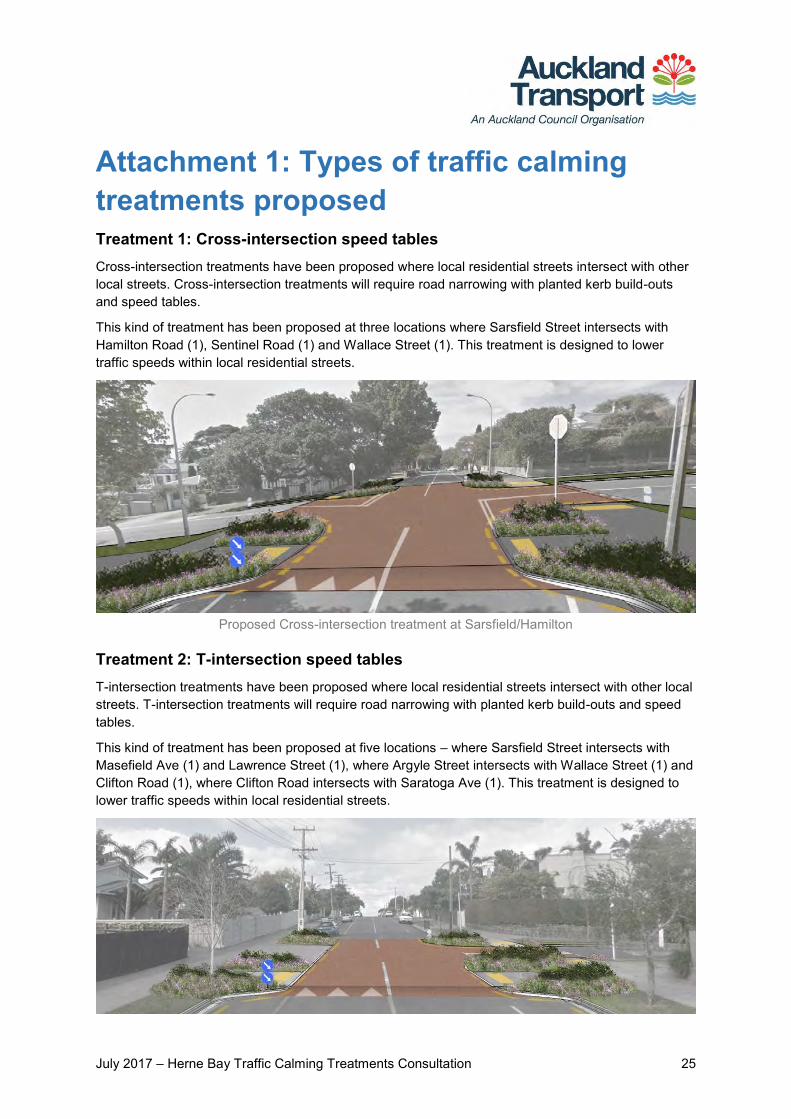
Attachment 1: Types of traffic calming treatments proposed Treatment 1: Cross-intersection speed tables Cross-intersection treatments have been proposed where local residential streets intersect with other local streets. Cross-intersection treatments will require road narrowing with planted kerb build-outs and speed tables.
This kind of treatment has been proposed at three locations where Sarsfield Street intersects with Hamilton Road (1), Sentinel Road (1) and Wallace Street (1). This treatment is designed to lower traffic speeds within local residential streets.
Proposed Cross-intersection treatment at Sarsfield/Hamilton
Treatment 2: T-intersection speed tables T-intersection treatments have been proposed where local residential streets intersect with other local streets. T-intersection treatments will require road narrowing with planted kerb build-outs and speed tables.
This kind of treatment has been proposed at five locations – where Sarsfield Street intersects with Masefield Ave (1) and Lawrence Street (1), where Argyle Street intersects with Wallace Street (1) and Clifton Road (1), where Clifton Road intersects with Saratoga Ave (1). This treatment is designed to lower traffic speeds within local residential streets.
July 2017 – Herne Bay Traffic Calming Treatments Consultation 26
Proposed T-intersection treatment at Argyle/Clifton
Treatment 3: Mid-block speed tables Mid-block treatments have been proposed in the middle of local residential streets. This will require street narrowing with planted kerb build-outs and speed tables. This kind of treatment has been proposed at nine different locations along Hamilton Road (2), Sentinel Road (2), Lawrence Street (2), Argyle Street (1), Wallace Street (1) and Clifton Road (1).
Proposed Mid-block treatments on Hamilton Road
Treatment 4: Boundary speed tables Boundary treatments have been proposed where local residential streets intersect with arterial roads. This will require road narrowing with planted kerb build-outs and speed tables. This kind of treatment has been proposed at five locations – where Jervois Road intersects with Hamilton Road (1), Sentinel Road (1), Lawrence Street (1) and Salisbury Road (1) and where Sarsfield Street intersects with Curran Street (1). This treatment is designed to lower traffic speeds within local residential streets.
Proposed Boundary treatment at Lawrence/Jervois
July 2017 – Herne Bay Traffic Calming Treatments Consultation 27
Attachment 2: Feedback form
July 2017 – Herne Bay Traffic Calming Treatments Consultation 28
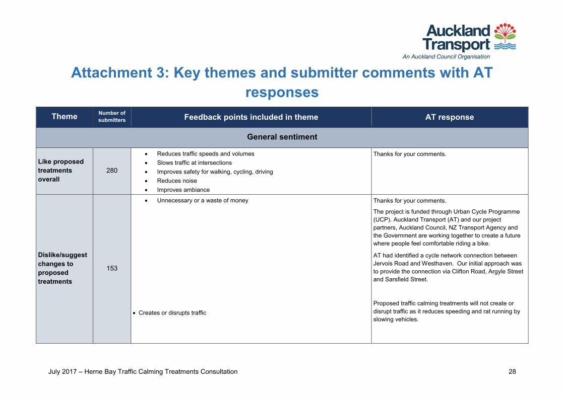
Attachment 3: Key themes and submitter comments with AT responses
Theme Number of submitters Feedback points included in theme AT response
General sentiment
Like proposed treatments overall
280
Reduces traffic speeds and volumes Slows traffic at intersections Improves safety for walking, cycling, driving Reduces noise Improves ambiance
Thanks for your comments.
Dislike/suggest changes to proposed treatments
153
Unnecessary or a waste of money
Creates or disrupts traffic
Thanks for your comments.
The project is funded through Urban Cycle Programme (UCP). Auckland Transport (AT) and our project partners, Auckland Council, NZ Transport Agency and the Government are working together to create a future where people feel comfortable riding a bike.
AT had identified a cycle network connection between Jervois Road and Westhaven. Our initial approach was to provide the connection via Clifton Road, Argyle Street and Sarsfield Street.
Proposed traffic calming treatments will not create or disrupt traffic as it reduces speeding and rat running by slowing vehicles.
July 2017 – Herne Bay Traffic Calming Treatments Consultation 29
Theme Number of submitters Feedback points included in theme AT response
Creates more noise
Ineffective Won’t improve cycling
As we are installing speed tables and not speed humps, noise is not likely to be an issue. Speed table ramps have a gentle slope and a flat top, which allows vehicles to move smoothly up, across and down without scraping cars. Proposed treatments would be effective in slowing down traffic entering residential streets from arterial roads and other local residential streets. People on bikes can take any of the traffic calmed streets between Jervois Road and Sarsfield Street connecting to Westhaven via Curran Street.
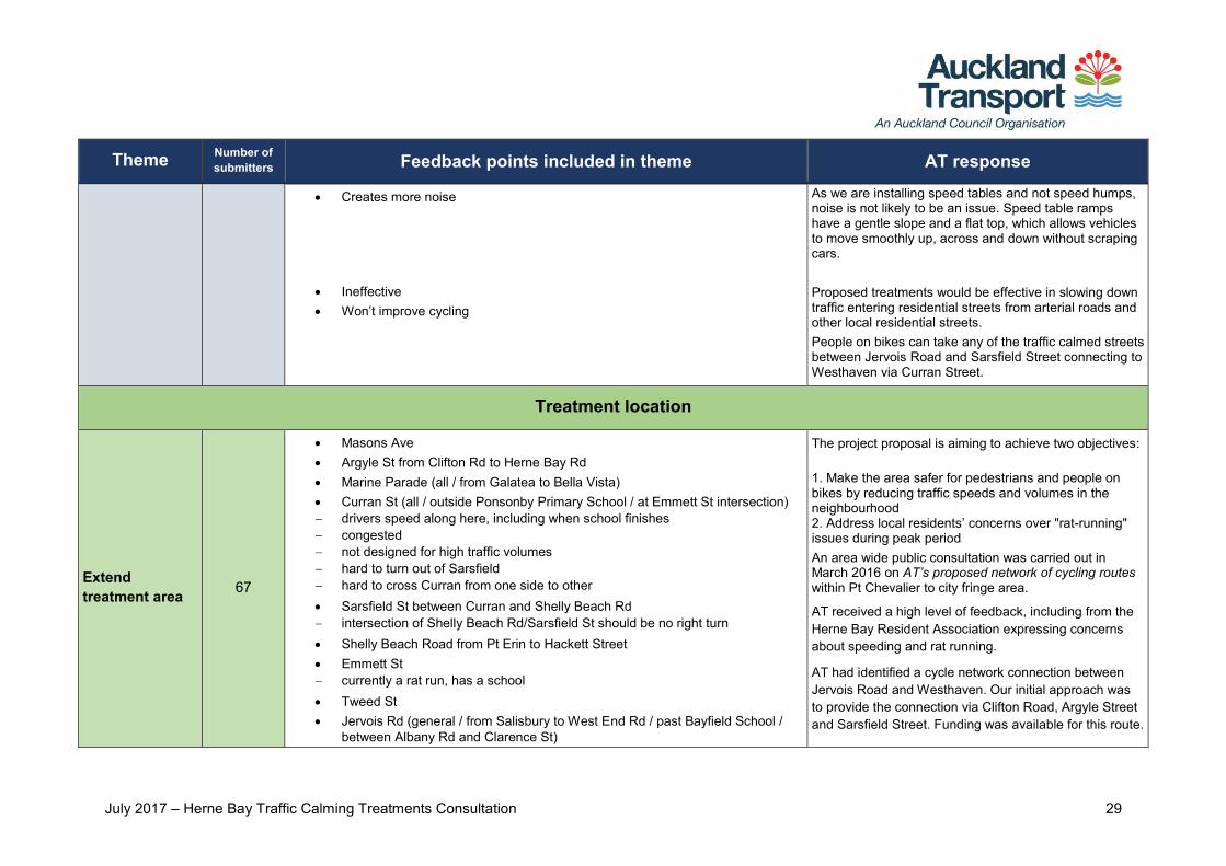
Treatment location
Extend treatment area 67
Masons Ave Argyle St from Clifton Rd to Herne Bay Rd Marine Parade (all / from Galatea to Bella Vista) Curran St (all / outside Ponsonby Primary School / at Emmett St intersection) drivers speed along here, including when school finishes congested not designed for high traffic volumes hard to turn out of Sarsfield hard to cross Curran from one side to other Sarsfield St between Curran and Shelly Beach Rd intersection of Shelly Beach Rd/Sarsfield St should be no right turn Shelly Beach Road from Pt Erin to Hackett Street Emmett St currently a rat run, has a school Tweed St Jervois Rd (general / from Salisbury to West End Rd / past Bayfield School /
between Albany Rd and Clarence St)
The project proposal is aiming to achieve two objectives: 1. Make the area safer for pedestrians and people on bikes by reducing traffic speeds and volumes in the neighbourhood 2. Address local residents’ concerns over "rat-running" issues during peak period An area wide public consultation was carried out in March 2016 on AT’s proposed network of cycling routes within Pt Chevalier to city fringe area.
AT received a high level of feedback, including from the Herne Bay Resident Association expressing concerns about speeding and rat running.
AT had identified a cycle network connection between Jervois Road and Westhaven. Our initial approach was to provide the connection via Clifton Road, Argyle Street and Sarsfield Street. Funding was available for this route.

July 2017 – Herne Bay Traffic Calming Treatments Consultation 30
Theme Number of submitters Feedback points included in theme AT response
John St/Jervois Rd intersection currently congested lots of accidents here suggest speed bumps at both entrances to BP station Wharf Rd suggest boundary speed table suggest Treatment 1 across Jervois/Wharf/Clifton discourage right turns into Clifton (day care + school here) More in residential areas generally / "area-wide" approach
However, taking on board consultation feedback, AT had investigated implementing traffic calming treatments on several streets rather than a cycle lane on a particular street. This would address local community issues around speeding and rat running.
The suggested streets (i.e. Shelly Beach Rd, Emmet St, Tweed St, Wharf Rd, and others) were not identified as the preferred cycling routes Thus, these streets are currently unfunded. The scope of the project does not extend as far as the suggested streets. Suggestions to extend the Local Area Traffic Management (LATM) treatments to the wider area is noted and to be considered for future projects. Concerns regarding Curran St traffic flow and speed are noted and will be passed on to AT traffic operations team to monitor and provide necessary treatments as required.
Add extra treatment (in area)
35
Add Mid-block speed table on Stack St on Clifton Rd (general / near Jervois Rd) on Sarsfield between Sentinel & Hamilton Roads on Hamilton Rd more Mid-block speed tables in general
Suggested additional treatments would result in speed tables that are too close to each other. The spacing of treatments should be fit for purpose, but typically 80m to 120m intervals as any spacing outside of these ranges tends either to be ineffective at either slowing speeds or has the potential to increase noise. Post feedback analysis and further assessment, the speed table locations will stay as proposed.
Add Boundary speed table at Clifton-Jervois intersection (this end most dangerous, discourage right-
turning traffic from Jervois) at Wallace-Jervois intersection
AT will consider installing a boundary speed table at Clifton Road intersection with Jervois Road. It will be investigated as a part of this project.
July 2017 – Herne Bay Traffic Calming Treatments Consultation 31
Theme Number of submitters Feedback points included in theme AT response
The Wallace Street intersection with Jervois Road is already a signalised intersection. Therefore, traffic and pedestrian movements are managed and controlled by traffic signals. Thus, adding a boundary speed table at this intersection will not be appropriate.
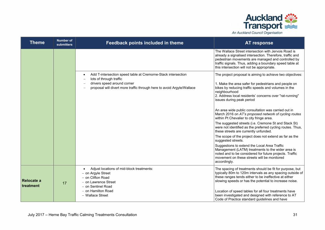
Add T-intersection speed table at Cremorne-Stack intersection lots of through traffic drivers speed around corner proposal will divert more traffic through here to avoid Argyle/Wallace
The project proposal is aiming to achieve two objectives: 1. Make the area safer for pedestrians and people on bikes by reducing traffic speeds and volumes in the neighbourhood 2. Address local residents’ concerns over "rat-running" issues during peak period An area wide public consultation was carried out in March 2016 on AT’s proposed network of cycling routes within Pt Chevalier to city fringe area. The suggested streets (i.e. Cremone St and Stack St) were not identified as the preferred cycling routes. Thus, these streets are currently unfunded. The scope of the project does not extend as far as the suggested streets. Suggestions to extend the Local Area Traffic Management (LATM) treatments to the wider area is noted and to be considered for future projects. Traffic movement on these streets will be monitored accordingly.
Relocate a treatment 17
Adjust locations of mid-block treatments: on Argyle Street on Clifton Road on Lawrence Street on Sentinel Road on Hamilton Road Wallace Street
The spacing of treatments should be fit for purpose, but typically 80m to 120m intervals as any spacing outside of these ranges tends either to be ineffective at either slowing speeds or has the potential to increase noise. Location of speed tables for all four treatments have been investigated and designed with reference to AT Code of Practice standard guidelines and have
July 2017 – Herne Bay Traffic Calming Treatments Consultation 32
Theme Number of submitters Feedback points included in theme AT response
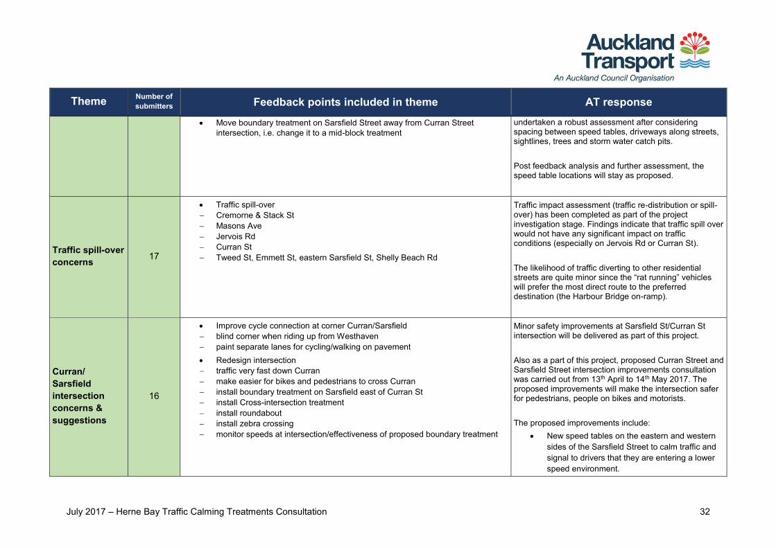
Move boundary treatment on Sarsfield Street away from Curran Street intersection, i.e. change it to a mid-block treatment
undertaken a robust assessment after considering spacing between speed tables, driveways along streets, sightlines, trees and storm water catch pits. Post feedback analysis and further assessment, the speed table locations will stay as proposed.
Traffic spill-over concerns 17
Traffic spill-over Cremorne & Stack St Masons Ave Jervois Rd Curran St Tweed St, Emmett St, eastern Sarsfield St, Shelly Beach Rd
Traffic impact assessment (traffic re-distribution or spill-over) has been completed as part of the project investigation stage. Findings indicate that traffic spill over would not have any significant impact on traffic conditions (especially on Jervois Rd or Curran St). The likelihood of traffic diverting to other residential streets are quite minor since the “rat running” vehicles will prefer the most direct route to the preferred destination (the Harbour Bridge on-ramp).
Curran/ Sarsfield intersection concerns & suggestions
16
Improve cycle connection at corner Curran/Sarsfield blind corner when riding up from Westhaven paint separate lanes for cycling/walking on pavement Redesign intersection traffic very fast down Curran make easier for bikes and pedestrians to cross Curran install boundary treatment on Sarsfield east of Curran St install Cross-intersection treatment install roundabout install zebra crossing monitor speeds at intersection/effectiveness of proposed boundary treatment
Minor safety improvements at Sarsfield St/Curran St intersection will be delivered as part of this project. Also as a part of this project, proposed Curran Street and Sarsfield Street intersection improvements consultation was carried out from 13th April to 14th May 2017. The proposed improvements will make the intersection safer for pedestrians, people on bikes and motorists. The proposed improvements include:
New speed tables on the eastern and western sides of the Sarsfield Street to calm traffic and signal to drivers that they are entering a lower speed environment.
July 2017 – Herne Bay Traffic Calming Treatments Consultation 33
Theme Number of submitters Feedback points included in theme AT response
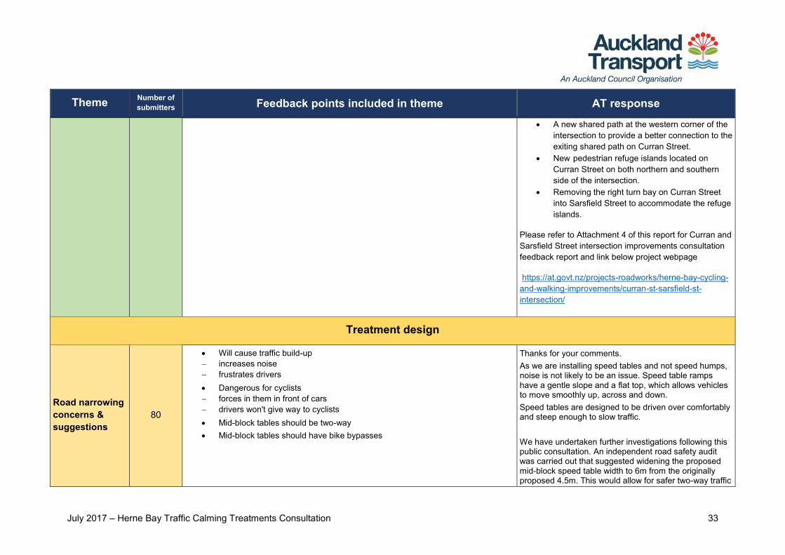
A new shared path at the western corner of the intersection to provide a better connection to the exiting shared path on Curran Street.
New pedestrian refuge islands located on Curran Street on both northern and southern side of the intersection.
Removing the right turn bay on Curran Street into Sarsfield Street to accommodate the refuge islands.
Please refer to Attachment 4 of this report for Curran and Sarsfield Street intersection improvements consultation feedback report and link below project webpage
https://at.govt.nz/projects-roadworks/herne-bay-cycling-and-walking-improvements/curran-st-sarsfield-st-intersection/
Treatment design
Road narrowing concerns & suggestions
80
Will cause traffic build-up increases noise frustrates drivers Dangerous for cyclists forces in them in front of cars drivers won't give way to cyclists Mid-block tables should be two-way Mid-block tables should have bike bypasses
Thanks for your comments. As we are installing speed tables and not speed humps, noise is not likely to be an issue. Speed table ramps have a gentle slope and a flat top, which allows vehicles to move smoothly up, across and down. Speed tables are designed to be driven over comfortably and steep enough to slow traffic. We have undertaken further investigations following this public consultation. An independent road safety audit was carried out that suggested widening the proposed mid-block speed table width to 6m from the originally proposed 4.5m. This would allow for safer two-way traffic
July 2017 – Herne Bay Traffic Calming Treatments Consultation 34
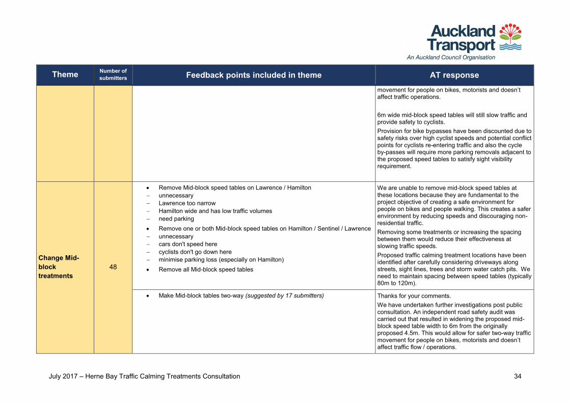
Theme Number of submitters Feedback points included in theme AT response
movement for people on bikes, motorists and doesn’t affect traffic operations. 6m wide mid-block speed tables will still slow traffic and provide safety to cyclists. Provision for bike bypasses have been discounted due to safety risks over high cyclist speeds and potential conflict points for cyclists re-entering traffic and also the cycle by-passes will require more parking removals adjacent to the proposed speed tables to satisfy sight visibility requirement.
Change Mid-block treatments
48
Remove Mid-block speed tables on Lawrence / Hamilton unnecessary Lawrence too narrow Hamilton wide and has low traffic volumes need parking Remove one or both Mid-block speed tables on Hamilton / Sentinel / Lawrence unnecessary cars don't speed here cyclists don't go down here minimise parking loss (especially on Hamilton) Remove all Mid-block speed tables
We are unable to remove mid-block speed tables at these locations because they are fundamental to the project objective of creating a safe environment for people on bikes and people walking. This creates a safer environment by reducing speeds and discouraging non-residential traffic. Removing some treatments or increasing the spacing between them would reduce their effectiveness at slowing traffic speeds. Proposed traffic calming treatment locations have been identified after carefully considering driveways along streets, sight lines, trees and storm water catch pits. We need to maintain spacing between speed tables (typically 80m to 120m).
Make Mid-block tables two-way (suggested by 17 submitters) Thanks for your comments. We have undertaken further investigations post public consultation. An independent road safety audit was carried out that resulted in widening the proposed mid-block speed table width to 6m from the originally proposed 4.5m. This would allow for safer two-way traffic movement for people on bikes, motorists and doesn’t affect traffic flow / operations.
July 2017 – Herne Bay Traffic Calming Treatments Consultation 35
Theme Number of submitters Feedback points included in theme AT response
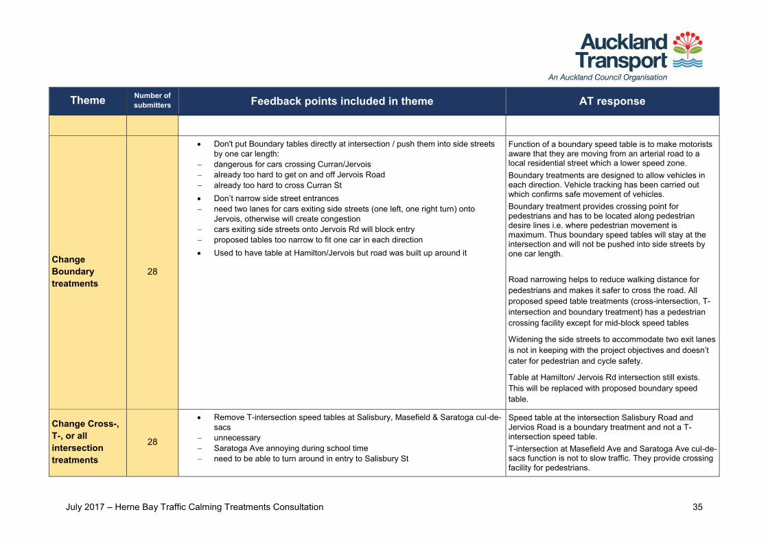
Change Boundary treatments
28
Don't put Boundary tables directly at intersection / push them into side streets by one car length:
dangerous for cars crossing Curran/Jervois already too hard to get on and off Jervois Road already too hard to cross Curran St Don’t narrow side street entrances need two lanes for cars exiting side streets (one left, one right turn) onto
Jervois, otherwise will create congestion cars exiting side streets onto Jervois Rd will block entry proposed tables too narrow to fit one car in each direction Used to have table at Hamilton/Jervois but road was built up around it
Function of a boundary speed table is to make motorists aware that they are moving from an arterial road to a local residential street which a lower speed zone. Boundary treatments are designed to allow vehicles in each direction. Vehicle tracking has been carried out which confirms safe movement of vehicles. Boundary treatment provides crossing point for pedestrians and has to be located along pedestrian desire lines i.e. where pedestrian movement is maximum. Thus boundary speed tables will stay at the intersection and will not be pushed into side streets by one car length. Road narrowing helps to reduce walking distance for pedestrians and makes it safer to cross the road. All proposed speed table treatments (cross-intersection, T-intersection and boundary treatment) has a pedestrian crossing facility except for mid-block speed tables
Widening the side streets to accommodate two exit lanes is not in keeping with the project objectives and doesn’t cater for pedestrian and cycle safety.
Table at Hamilton/ Jervois Rd intersection still exists. This will be replaced with proposed boundary speed table.
Change Cross-, T-, or all intersection treatments
28
Remove T-intersection speed tables at Salisbury, Masefield & Saratoga cul-de-sacs
unnecessary Saratoga Ave annoying during school time need to be able to turn around in entry to Salisbury St
Speed table at the intersection Salisbury Road and Jervios Road is a boundary treatment and not a T- intersection speed table. T-intersection at Masefield Ave and Saratoga Ave cul-de-sacs function is not to slow traffic. They provide crossing facility for pedestrians.
July 2017 – Herne Bay Traffic Calming Treatments Consultation 36
Theme Number of submitters Feedback points included in theme AT response
Remove all tables except along Argyle / Sarsfield Reduce / remove tables along Sarsfield Remove all T-intersection tables (unnecessary)
Removing some treatments or increasing the spacing between them would reduce their effectiveness at slowing traffic speeds. Inclusion of speed tables is fundamental to the project objective of creating a safe environment for people on bikes and people walking. This creates a safer environment by reducing speeds and discouraging non-residential traffic.
T-intersection speed tables along Sarsfield may block driveway access The T-intersection treatment at Sarsfield Street has been designed to accommodate driveway access.
Speed table height or length concerns
22
Don't make speed tables too high or abrupt: make lower than usual to keep noise down minimise damage to cars/drivers/cyclists exacerbation of driver injuries enable drivers in low cars to travel at legal speed Make high enough (to ensure cars reduce speed sufficiently) Prefer short speed tables to reduce parking loss Suggest less steep on outer edges of speed tables so less harsh on cyclists Suggest mountable kerbs at Boundary treatments so easier to drive in and out
of side streets
Speed tables are designed to be driven over comfortably and steep enough to slow traffic. Speed tables will be 100mm high with gentle side ramps, except for boundary speed tables which will be 50mm high with gentle side ramps. This complies with the Auckland Transport Code of Practice guidelines. Kerb details will be investigated at detailed design stage. Suggestion on the gradient are noted. Gradient details will be investigated at detailed design stage.
Visibility concerns 10
Visibility poor along Sarsfield St when exiting driveways when turning into Sarsfield St from side streets narrow with parked cars either side due to existing speed treatments at Wallace St intersection Poor visibility when exiting driveways in area due to cars parked too close Concern that proposed speed tables will block sightlines at driveways /
intersections
Sightline assessments will be carried out during the detailed design phase to ensure the proposal does not limit visibility at key locations, including driveways and intersections. Our proposal design will ensure that we meet the sightline requirements.
July 2017 – Herne Bay Traffic Calming Treatments Consultation 37
Theme Number of submitters Feedback points included in theme AT response
Alternative treatments
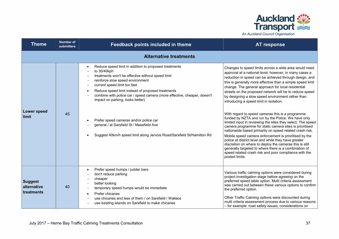
Lower speed limit 45
Reduce speed limit in addition to proposed treatments to 30/40kph treatments won't be effective without speed limit reinforce slow speed environment current speed limit too fast Reduce speed limit instead of proposed treatments combine with police car / speed camera (more effective, cheaper, doesn't
impact on parking, looks better)
Prefer speed cameras and/or police car general / at Sarsfield St / Masefield Ave Suggest 40km/h speed limit along Jervois Road/Sarsfield St/Hamilton Rd
Changes to speed limits across a wide area would need approval at a national level; however, in many cases a reduction in speed can be achieved through design, and this is generally more effective than a simple speed limit change. The general approach for local residential streets on the proposed network will be to reduce speed by designing a slow speed environment rather than introducing a speed limit in isolation.
With regard to speed cameras this is a programme funded by NZTA and run by the Police. We have only limited input in reviewing the sites they select. The speed camera programme for static camera sites is prioritised nationwide based primarily on speed related crash risk. Mobile speed camera enforcement is prioritised by the police at district level and while they have greater discretion on where to deploy the cameras this is still generally targeted to where there is a combination of speed related crash risk and poor compliance with the posted limits.
Suggest alternative treatments
40
Prefer speed humps / judder bars don't reduce parking cheaper better looking temporary speed humps would be immediate Prefer chicanes use chicanes and less of them / on Sarsfield / Wallace use existing islands on Sarsfield to make chicanes
Various traffic calming options were considered during project investigation stage before agreeing on the preferred speed table option. Multi criteria assessment was carried out between these various options to confirm the preferred option. Other Traffic Calming options were discounted during multi criteria assessment process due to various reasons – for example: road safety issues, considerations on
July 2017 – Herne Bay Traffic Calming Treatments Consultation 38
Theme Number of submitters Feedback points included in theme AT response
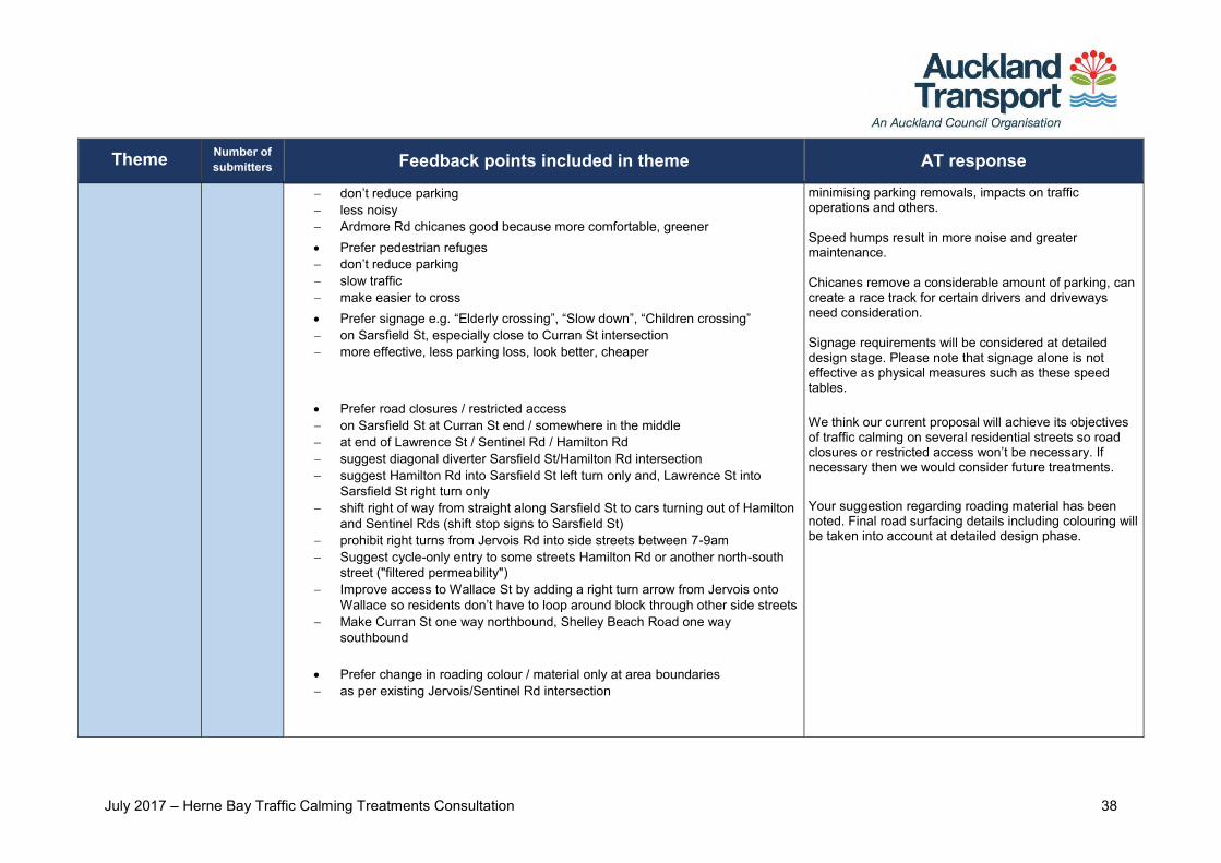
don’t reduce parking less noisy Ardmore Rd chicanes good because more comfortable, greener Prefer pedestrian refuges don’t reduce parking slow traffic make easier to cross Prefer signage e.g. “Elderly crossing”, “Slow down”, “Children crossing” on Sarsfield St, especially close to Curran St intersection more effective, less parking loss, look better, cheaper
Prefer road closures / restricted access on Sarsfield St at Curran St end / somewhere in the middle at end of Lawrence St / Sentinel Rd / Hamilton Rd suggest diagonal diverter Sarsfield St/Hamilton Rd intersection suggest Hamilton Rd into Sarsfield St left turn only and, Lawrence St into
Sarsfield St right turn only shift right of way from straight along Sarsfield St to cars turning out of Hamilton
and Sentinel Rds (shift stop signs to Sarsfield St) prohibit right turns from Jervois Rd into side streets between 7-9am Suggest cycle-only entry to some streets Hamilton Rd or another north-south
street ("filtered permeability") Improve access to Wallace St by adding a right turn arrow from Jervois onto
Wallace so residents don’t have to loop around block through other side streets Make Curran St one way northbound, Shelley Beach Road one way
southbound Prefer change in roading colour / material only at area boundaries as per existing Jervois/Sentinel Rd intersection
minimising parking removals, impacts on traffic operations and others. Speed humps result in more noise and greater maintenance. Chicanes remove a considerable amount of parking, can create a race track for certain drivers and driveways need consideration. Signage requirements will be considered at detailed design stage. Please note that signage alone is not effective as physical measures such as these speed tables. We think our current proposal will achieve its objectives of traffic calming on several residential streets so road closures or restricted access won’t be necessary. If necessary then we would consider future treatments. Your suggestion regarding roading material has been noted. Final road surfacing details including colouring will be taken into account at detailed design phase.
July 2017 – Herne Bay Traffic Calming Treatments Consultation 39
Theme Number of submitters Feedback points included in theme AT response
Other treatment design concerns & suggestions
23
Stack/Cremorne St stop sign issues drivers not stopping suggest replace with stop sign at intersection of Cremorne/Argyle Streets cut fence at corner paint midline on Cremorne St
Thanks for your comments. Implementing stop/give-way control requires consultation and resolving. The safety aspects of this intersection do not suggest a stop control as there have been no crashes at this location and so we would recommend a give-way control is introduced instead. For AT to install a give-way control here we would have to first consult on a proposal.
As the give-way control is legally enforceable it needs to be consulted upon and resolved. We may be able to propose a give-way control after further investigation and the investigation can be initiated by one person’s request.
They can raise the issue for investigation by emailing [email protected] with the details of the issue.
Regarding fence, if it is on private land the owner of the property will have to be asked. Regarding painting midline on Cremorne Street, AT only installs centre lines on arterial/principal and collector roads carrying substantial volumes of non-local traffic.
Add pedestrian/mobility scooter crossings to all modified intersections at Mid-block tables to Clifton/Jervois Rd intersection
Pedestrian crossing facility is provided at the T, cross and boundary treatment intersections. The proposal will provide a safer and better crossing facility for pedestrians and people on mobility scooters. No pedestrian crossing facility will be provided at the mid-block speed table treatment due to safety and sight visibility concerns.
July 2017 – Herne Bay Traffic Calming Treatments Consultation 40
Theme Number of submitters Feedback points included in theme AT response
Give Clifton Rd traffic priority over Argyle St traffic This would encourage rat-running through these streets. Discouraging through traffic is a key objective of this project.
Suggest signage at intersections (slow down etc.) at speed tables, yellow 20 signs similar to John St at Mid-block tables as in Vermont St giving bikes and pedestrians priority
Thanks for your comments. Signage will be developed during detailed design stage.
Remove white midline on Sarsfield St Thanks for your feedback. Line markings will be investigated during detailed design stage.
Sarsfield too busy to be a cycle route Speed tables will help to reduce traffic speeds and volumes. This would create a safer route for cyclists.
Leave space for wheelie bins on kerb Thanks for your comments. We will ensure that there is sufficient space to collect bins from the kerb.
Speed tables on intersection should have right angle corners (not curves) to minimise parking loss
At the corners of existing intersections, there are “no stopping broken yellow line” markings which do not allow any parking. Thus, parking losses at intersection corners are not required.
Ensure streets swept properly after treatments Thanks for your comments. This will be a part of the construction contract requirements.

July 2017 – Herne Bay Traffic Calming Treatments Consultation 41
Theme Number of submitters Feedback points included in theme AT response
Cycling
Suggest dedicated cycleways
45
Put in cycle lanes general / on Sarsfield / along Sarsfield, Argyle & Clifton/on Wallace St/on main
roads physically separated lanes painted cycle lanes shared path along Sarsfield separation only way to improve safety would mean children could cycle to school Make space for cycle lanes by: removing parking narrowing traffic lanes narrowing footpaths & grass verges swapping speed tables & plantings for temporary speed bumps
An area wide public consultation was carried out in March 2016 on AT’s proposed network of cycling routes within Pt Chevalier to city fringe area.
AT received a high level of feedback, including from the Herne Bay Resident Association expressing concerns about speeding and rat running.
AT had identified a cycle network connection between Jervois Road and Westhaven. Our initial approach was to provide the connection via Clifton Road, Argyle Street and Sarsfield Street.
However, taking on board consultation feedback, AT had investigated implementing traffic calming treatments on several streets rather than a cycle lane on a particular street. This would address both cycling route and local community issues around speeding and rat running.
The proposal is aiming to achieve two objectives: 1. Make the area safer for pedestrian and people on bikes by reducing traffic speeds and volumes in the neighbourhood. 2. Address local residents’ concerns over "rat-running" issues during peak period Following investigation, the most effective treatment to achieve these 2 main objectives is a local area
July 2017 – Herne Bay Traffic Calming Treatments Consultation 42
Theme Number of submitters Feedback points included in theme AT response
management traffic (LATM) treatment because a dedicated cycleway along a single route will not address the "rat running" issues in the parallel residential streets. And, it also requires significant parking removals to make space for the dedicated cycle lanes.
Suggest bike bypasses through treatments
26
Put street-level bike bypasses 1.3m wide at Mid-block tables at Mid-block, Boundary, and along the top portion of the "T" at T-intersection
tables where wide enough at all tables avoid bumps for cyclists Make kerb build-outs mountable for cyclists Current design unsafe means cars can't legally pass cyclists on tables forces cyclists in front of cars discourages use of route for cyclists
Thanks for your feedback. Post feedback analysis an independent road safety audit process was carried out, which proposed that mid-block speed table width to be widened to 6m from previous 4.5m. Suggestion for bike bypasses have been discounted due to safety risks over high cyclist speeds and potential conflict points for cyclists re-entering traffic and also the cycle by-passes will require more parking removals adjacent to the proposed speed tables to satisfy sight visibility requirement. Local residents want minimum car park loss.
Won't improve cycling 26
Tables create dangerous pinch points Mid-block / all increases competition between cars and bikes Bumps unpleasant / difficult to ride over Treatments won't benefit cyclists bad for the recreational and sports cyclists who currently use route cyclists will still have to weave in between parked cars to avoid drivers
Thanks for your comments. AT has undertaken further investigations post public consultation. An independent road safety audit was carried that resulted in widening the proposed mid-block speed table width to 6m from previous 4.5m. This would allow for safer two-way traffic movement and won’t create pinch points. As we are installing speed tables and not speed humps, it won’t be unpleasant. Speed table ramps have a gentle
July 2017 – Herne Bay Traffic Calming Treatments Consultation 43
Theme Number of submitters Feedback points included in theme AT response
slope and a flat top, which allows vehicles to move smoothly up, across and down. Speed tables are designed to be driven over comfortably and steep enough to slow traffic. Proposed treatments would benefit people on bikes, pedestrians and motorists. People on bikes can take any residential street that has been traffic calmed.
Will improve cycling 7
Makes cycling safer in general / on Sarsfield provides alternatives better than nothing
Thanks for your comments.
Other cycling suggestions 25
Paint sharrows in combination with reduced speed limit make clear to motorists that need to share
Thanks for comments. Road markings will be considered during Detail Design stage.
Want way-finding signage Want share the road signage
Signage will be considered during Detailed Design stage.
Remove parking general / on Wallace St on one side of street to widen both (shared) lanes on both sides of road to make space for cycle lanes
Our proposal focuses on Local Area Traffic Management (LATM) through speed calming treatments which requires minimum car park removal. Local residents are not supportive of car park removal along streets (only where it is necessary).
Clifton Rd inappropriate for cyclists cyclists don't and shouldn't use Clifton Rd too steep dangerous with school children and school bus build-up Masons Ave a better option
Thanks for your comments. An area wide public consultation was carried out in March 2016 on AT’s proposed network of cycling routes within Pt Chevalier to city fringe area. Clifton Rd was identified as a preferred cycling route.
AT had identified a cycle network connection between Jervois Road and Westhaven. Our initial approach was
July 2017 – Herne Bay Traffic Calming Treatments Consultation 44
Theme Number of submitters Feedback points included in theme AT response
to provide the connection via Clifton Road, Argyle Street and Sarsfield Street.
Consultation feedback raised local residents concerns regarding “rat running” within the residential streets. AT has investigated implementing traffic calming treatments on several streets rather than a cycle lane on a particular street. Local Area Traffic Management (LATM) will help to achieve these concerns and meet needs of people on bikes, pedestrians and motorists.
Need to compensate residents for loss of amenities used for cycling The proposed improvements will bring benefits to all pedestrians, people on bikes and motorists. We want to create a slower speed environment so people on bikes and motorists can share the road safely. This will also create a safer and more enjoyable environment for pedestrians and children.
Improve cycling in other areas 26
Support proposed Pt Chev to city fringe cycleways / want ASAP Install cycleways: along Jervois Road (remove parking / use footpath, don't remove parking) along east end of Curran St (ideally using footpath on park (northern) side) along Shelly Beach Road (easiest way to Herne Bay from Westhaven) along Curran St along Hamilton and John down College Hill Rd, along Ponsonby Rd connecting proposed Greenways Grammar path with Skypath Curran St to Westhaven walk/cycleway make downhill cyclists use road (not enough space for bi-directional)
Thanks for your comments. Based on public consultation feedback on AT’s proposed network of cycling routes - completed in March 2016, AT have noted the preferred cycling routes within the Pt Chev to city fringe area. At this stage, there are several cycling projects that fall under the Urban Cycle Fund 2015 -18 programme and currently have funding available. Other cycling routes that are currently unfunded will be considered as part of future cycle projects scoped for 2018 – 23. Please refer to Pt Chevalier to City Fringe revised cycle network map We have another cycling project ‘Westhaven to CBD’ adjacent to this project which will connect Curran St North to Westhaven then to CBD.
July 2017 – Herne Bay Traffic Calming Treatments Consultation 45
Theme Number of submitters Feedback points included in theme AT response
introduce cycling speed limit Cycleway usage encourage cyclists to use Westhaven bridge force to use cycleways where they exist All shared paths should have separate sides for cyclists and pedestrians
Oppose cycleway along Jervois Rd
People on bikes actively use cycleways. There are some parts within their journey where they need to merge with road traffic to get to their final destination. Each cycle journey is different depending on the route that cyclist takes. In most situations, we try separating people on bikes and pedestrians using shared paths. In some situations, it is not feasible due to limited space available. Jervois Rd is currently unfunded for investigation and construction 2019 and beyond. Please refer to Pt Chevalier to City Fringe revised cycle network map
Parking
Parking availability concerns
79
Don’t want to lose parking oppose treatments due to parking removal appreciate minimal parking removal suggest minimise parking removal suggest make more parking proposal will exacerbate existing parking issues
Prefer restricted parking on Sarsfield to one side move centre line over to create room for cyclists
Thanks for your comments. The current proposal aims to minimise car park removals while meeting project objectives. During early investigation, an option to put in a dedicated cycleway along a preferred route has been discounted since it will not meet the project objectives and will result in significant parking removals along the preferred route. Our Local Area Traffic Management (LATM) approach for Herne Bay residential streets requires minimum car park removal. The proposed mid-block speed table treatments requires loss of two car park at each location (18 car park removal). However, additional parking removal will be required close to mid-block speed tables to meet sightline requirements for motorists.
July 2017 – Herne Bay Traffic Calming Treatments Consultation 46
Theme Number of submitters Feedback points included in theme AT response
We will try our best to keep as much parking as possible and meet project objectives.
Illegal parking concerns 18
Prevent parking too close to / over driveways: general / near Herne Bay beach / on Sarsfield St / along Shelly Beach Rd / at
southern end Hamilton Rd yellow lines already painted on Curran St but cars still park over Prevent parking close to intersections: general / on Jervois Rd / at Argyle St/Clifton Rd / at corner Stack & Cremorne leave 2-3 car width space paint yellow lines Prevent illegal parking at Mid-block speed tables Cars currently parking illegally in communal driveways Concern about double parking around Bayfield School
Thanks for your comments. Sightline assessments will be carried out during detailed design to ensure the proposal does not limit visibility at key locations i.e. driveways and intersections. These concerns will be forwarded to our Parking Compliance team for their ongoing monitoring and action. Changes to road marking to be considered during detailed design stage.
Commuter parking concerns & suggestions
16
Commuter parking concerns: general / on Curran St / Hamilton Rd / Sentinel Rd / Sarsfield St suggest Residential Parking Zone (RPZ) suggest time limits Long-term parking issues ("street garaging")
Thanks for your comments. Demand for parking in the fringe suburbs around central Auckland has increased over the last 5 years and Auckland Transport has received a considerable and increasing number of complaints from residents regarding the lack of parking availability on their streets. In response to this AT has developed an approach to managing this issue which positively prioritises residents and short term parking through the establishment of 2 hour parking zones for which eligible applicants can apply for an annual permit or daily coupon which exempts them from the restriction. This approach was set out in the Auckland Transport Parking Strategy which was widely consulted on.
July 2017 – Herne Bay Traffic Calming Treatments Consultation 47
Theme Number of submitters Feedback points included in theme AT response
Unfortunately the volume of requests Auckland Transport receives on this subject is such that it is impossible to respond to them all immediately. Instead we have a work programme which allows us to prioritise our resources. We have added Herne Bay to this programme. AT is currently completing a proposal for Ponsonby and Parnell and will soon be consulting on a scheme for Grey Lynn and Grafton. At this stage we cannot give you a date when we will be able to consider a proposal for Herne Bay as our programme is very dependent on the delivery of the preceding proposals.
Other parking concerns & suggestions
14
Ban large vans/trucks on narrow roads (Sentinel) Thanks for your comments.
Truck volumes need to exceed 10% for a Heavy Goods Vehicles (HGV) ban on a road. It can be difficult to enforce bans due to limited police time and resources and so there needs to be evidence to support such a ban.
Concern about tradesmen/developers taking up parking Thanks for your comments. Please note that on street parking is for everyone including tradesmen/developers so we can’t limit it local residents only.
Emergency vehicle access concerns The proposed treatments will not compromise emergency vehicle access.
July 2017 – Herne Bay Traffic Calming Treatments Consultation 48
Theme Number of submitters Feedback points included in theme AT response
Suggest angle parking to avoid opening door hazard with cyclists Angle parking creates safety issues for cyclists and it makes it difficult for vehicle manoeuvring. Cyclists to use same lane as vehicles and on some sections we will paint Sharrow’s for people on bikes.
Aesthetics
Like treatment aesthetics 25
Like look of treatments narrowing of street environment will improve streetscape feels safer Like plants greener look appealing safer environment
Thanks for your support and feedback on our proposal.
Vegetation suggestions 24
Don't remove any trees general / in Sentinel Rd Suggest more trees, shrubs in general Don’t want plantings on Sarsfield St combination of new and existing plantings excessive Species for plantings want native plants, suggest small native flax need to be suitable for dry, coastal environment, low maintenance don't put gum trees (dislike those on Kelmarna Ave) keep consistent throughout neighbourhood Height of plantings keep plantings low (maintain visibility for exiting driveways, intersections)
No trees will be removed as a part of this proposal. We will be adding low level planting at the proposed treatment locations. This will create a greener environment and enhance look and feel of local streets in the Herne Bay area. We will not be adding any trees as a part of this proposal. Auckland Council arborist will be consulted on low level plant species that will form a part of planted kerb build-outs and speed tables. This will be determined during detailed design stage. Planting will be maintained by Auckland Council.
July 2017 – Herne Bay Traffic Calming Treatments Consultation 49
Theme Number of submitters Feedback points included in theme AT response
don't put trees as reducing sightlines dangerous add trees to plantings to reduce sightlines & slow people further Plantings need to be maintained council should look after concerned that because no longer maintain berms, won’t maintain plantings suggest teenager planting programme Don’t like plantings ugly dangerous because reduce visibility of pedestrians
already hard enough to reverse out of driveways
Dislike treatment aesthetics
15
Treatments unattractive don't like pink/red colour will ruin wide streets will reduce property values speed tables should be same colour as roads
Thanks for your comments. Your suggestion regarding roading /speed table material has been noted. Final road surfacing details including colouring will be taken into consideration during detailed design stage. We will comply with Auckland Transport standards.
Other aesthetics suggestions 6
Increase pavement size and plantings and reduce parking to make more pedestrian-friendly
This is a traffic calming treatments project aiming to achieve two objectives:
1) Make the area safer for pedestrians and people on bikes by reducing traffic speeds and volumes in the neighbourhood.
2) Address local resident’s concerns over rat-running issues during peak period.
Residents don’t support removal of car parks. Footpath extension and planting is a part of proposed speed tables that narrow road with planted kerb build-outs.
Underground power and fix footpaths This is outside scope of the project. We will pass this onto Road Corridor Maintenance team that looks after footpaths.
July 2017 – Herne Bay Traffic Calming Treatments Consultation 50
Theme Number of submitters Feedback points included in theme AT response
Maintain neighbourhood look This is the intention and was a key consideration following earlier public feedback.
Don't paint ugly cycle lanes, bus lanes, don’t install ugly signs Signage design will be developed during Detail Design stage. Signage strategy will comply with AT Code of Practice standard guidelines.
Behaviour and other
Behaviour & enforcement concerns
31
Motorist behaviour issues (need to change behaviour, enforce road rules) drivers rat-running drivers racing in area (concern speed treatments will encourage) need to enforce speed limits drivers ignoring stop and give way signs in general / at Stack & Cremorne St drivers neglectful / inconsiderate educate drivers about safe driving habits drivers going wrong way up Curran/Marina [Westhaven Drive], suggest make
one-way sign more visible at night red light running at Jervois/Curran Motorist behaviour not an issue proposal penalises "reasonable drivers" speeding not an issue, less than used to be Cyclist behaviour/enforcement loud cycle groups along Sarsfield in early morning inconsiderate cycling, 2-3 abreast, can't pass ignoring stop and give way signs educate cyclists on courtesy toward pedestrians Teach cyclists basic courtesy
Thanks for your comments. Feedback points under this theme relates to either education of cyclists, motorists, or pedestrians, regarding safety or consideration of others. Both the NZ Transport Agency and AT carry out education campaigns to promote cycling and encourage considerate behaviour between people walking, cycling and in cars. These suggestions will be forwarded to AT’s Campaigns team for consideration with public awareness campaigns. This proposal will help to traffic calm local residential streets and reduce speeding, rat running. Motorists, people on bikes and pedestrians will all have to be more aware and be respectful of each other.
July 2017 – Herne Bay Traffic Calming Treatments Consultation 51
Theme Number of submitters Feedback points included in theme AT response
to use existing cycleways to be quiet (early morning cycle gangs along Sarsfield)
Other suggestions 28
Public transport install underground trains / light rail install buses along Sarsfield / Jervois (permanent / during peak hours) Jervois Road improve pavements, particularly on northern side (difficult for elderly) prohibit right turns out of side streets along southern side Jervois Rd
(dangerous, pedestrian died recently) sync west & eastbound traffic lights at Jervois/Kelmarna intersection
(dangerous for eastbound cars turning right into Kelmarna) Install parking building on Ponsonby Road (reduce congestion) Harbour Bridge access: install second harbour crossing remove lights at access onto bridge Implement similar treatments in St Marys Bay / in Grey Lynn side streets along
Great North Rd Sweep roads after sealing (Emmett St, Argyle St) loose stones damaging property / noisy Implement alcohol ban in Herne Bay / on beach
Other comments made which are outside of the scope of this consultation, or the projects which will follow, have been or will be forwarded to the appropriate departments within Auckland Transport.
Thanks for your comments. This will be a part of the construction contract requirements.
Please contact Auckland Council directly regarding Alcohol Ban in Herne Bay or beach areas.
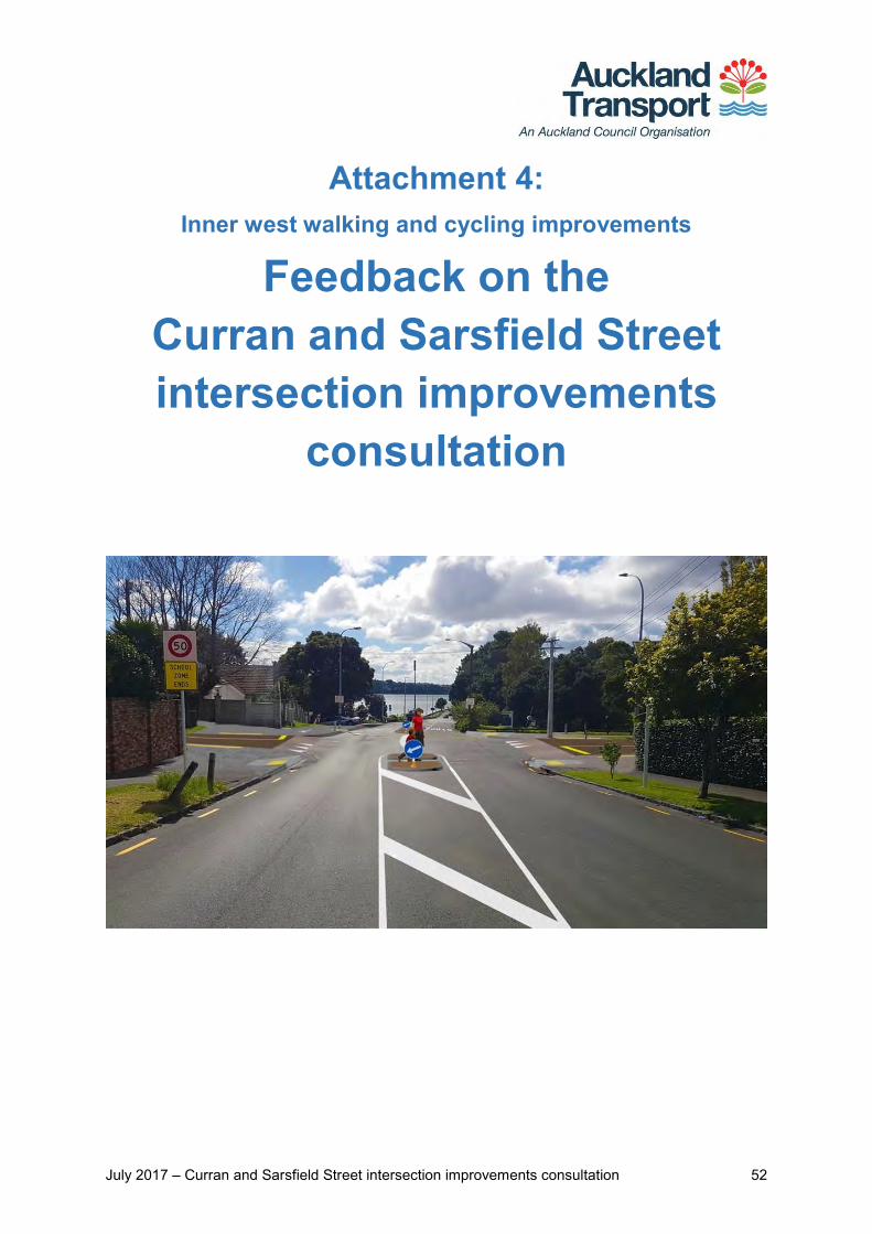
July 2017 – Curran and Sarsfield Street intersection improvements consultation 52
Attachment 4: Inner west walking and cycling improvements
Feedback on the Curran and Sarsfield Street intersection improvements
consultation
July 2017 – Curran and Sarsfield Street intersection improvements consultation 53
Summary Key themes in feedback 170 people submitted feedback to improve the intersection of Curran Street and Sarsfield Street. We have identified these major themes in your feedback:
Good support for the project in general. People liked slower traffic speeds, raised tables, wider footpath, pedestrian refuge islands, shared path/footpath and right turn removal. Notable positive response for the proposed design in its entirety (28% of all submitters)
A large proportion of respondents (36%) suggested the addition of more traffic calming treatments to Curran Street in particular
Concerns about and suggestions for improved cycling facility (28%)
Suggestions for improving pedestrian refuge safety (21%).
Outcome We have used your feedback to help us finalise the design of the proposed treatments. As a result, we have decided to:
Install new speed tables on Sarsfield Street, either side of its junction with Curran Street, to calm traffic and signal to drivers that they are entering a lower speed environment. Speed tables will have provision for a pedestrian crossing
Install a new shared path at the north-western corner of the Sarsfield Street and Curran Street intersection to provide a better connection to the existing shared path further north on Curran Street
Install new pedestrian refuge islands on Curran Street, located to the north and south of the Sarsfield Street intersection.
Remove the right-turn bay on Curran Street into Sarsfield Street to accommodate the refuge islands
Investigate installing pedestrian handrail barriers on both Curran Street pedestrian refuges
Next steps Construction is expected to start in late 2017 to June 2018.
July 2017 – Curran and Sarsfield Street intersection improvements consultation 54
Background Project information Auckland Transport (AT) is proposing improvements in the Herne Bay area as part of a wider cycling network from Point Chevalier to the city fringe. Our proposed changes to the Curran Street and Sarsfield Street intersection aim to make it safer for everyone by reducing vehicle speeds and providing a better environment for people walking and cycling, as part of the Herne Bay residential streets traffic calming treatments project that was open for public feedback from 17 Nov to 18 Dec 2016.
Additional consultation was carried out for the proposed Curran and Sarfield Street intersection improvements from 13 April to 14 May 2017 to address concerns raised in the Herne Bay residential streets traffic calming treatments project.
Previous public feedback Feedback we received during previous consultations in the Herne Bay area highlighted the following safety concerns at this intersection:
High traffic speed when approaching the intersection
Dangerous intersection for pedestrians and cyclists
No crossing facility from western Sarsfield Street to Point Erin Park and Point Erin Pool
No crossing facility on Curran Street near the intersection to provide safe access for children from Ponsonby Primary School.
We had also previously considered the inclusion of a cycle lane on the western side of Curran Street. Further investigation revealed that there is not enough road space to accommodate a cycle lane and pedestrian refuge islands. The refuge islands are necessary for pedestrian safety and to slow traffic.
Proposed improvements To address these concerns raised in previous consultation, we proposed the following improvements to the Curran and Sarsfield Streets intersection:
New speed tables on the eastern and western sides of the Sarsfield Street to calm traffic and signal to drivers that they are entering a lower speed environment
A new shared path at the western corner of the intersection to provide a better connection to the existing shared path on Curran Street
July 2017 – Curran and Sarsfield Street intersection improvements consultation 55
New pedestrian refuge islands on Curran Street, located on the northern side of the intersection for pedestrians crossing between Sarsfield Street and Point Erin Pool, and on the southern end of the intersection providing an additional crossing point for Ponsonby Primary School. The refuges are as wide as possible within the available road space to allow parents with prams, small groups of parents and children, people on bikes and wheelchairs to fit more comfortably. The islands also narrow the road to slow traffic approaching the intersection
Removing the right-turn bay on Curran Street into Sarsfield Street to accommodate the refuge islands.
The new design also subsequently includes a shared path, pram ramps, and footpath widening on the north-west end of Curran Street. Please see Appendix 1 for the proposed design for this intersection.
July 2017 – Curran and Sarsfield Street intersection improvements consultation 56
Consultation We consulted on the proposed design from 13 April to 14 May 2017.
Activities to raise awareness To let you know about our consultation, we:
Mailed consultation letters and feedback forms to 2,800 property owners and occupiers surrounding the intersection
Emailed the consultation letter to the Waitematā Local Board, Herne Bay Residents Association, Bike Auckland and Ponsonby Primary School
Set up a project webpage and an online feedback form on our website
Promoted the project on Facebook and posted information on Facebook through the Waitematā Local Board and Auckland Council pages, as well as on Neighbourly, Twitter and LinkedIn.
Giving feedback We asked you what aspects of the proposed design you liked and why, what aspects you would change and why, and any other comments or suggestions you had about the proposed design.
You could provide feedback using an online submission form (on our Have Your Say website) or a hard copy form that we posted to interested parties. See Appendix 2 at the end of this report for a copy of the feedback form.
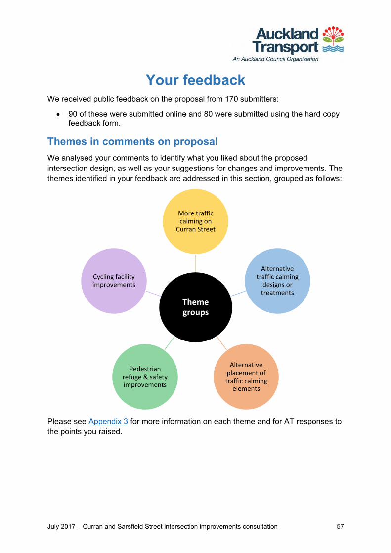
July 2017 – Curran and Sarsfield Street intersection improvements consultation 57
Your feedback We received public feedback on the proposal from 170 submitters:
90 of these were submitted online and 80 were submitted using the hard copy feedback form.
Themes in comments on proposal We analysed your comments to identify what you liked about the proposed intersection design, as well as your suggestions for changes and improvements. The themes identified in your feedback are addressed in this section, grouped as follows:
Please see Appendix 3 for more information on each theme and for AT responses to the points you raised.
Theme groups
More traffic calming on
Curran Street
Alternative traffic calming
designs or treatments
Alternative placement of traffic calming
elements
Pedestrian refuge & safety improvements
Cycling facility improvements
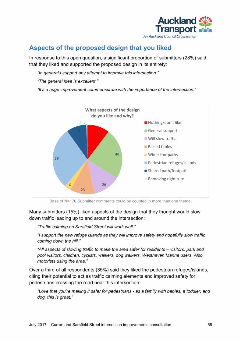
July 2017 – Curran and Sarsfield Street intersection improvements consultation 58
Aspects of the proposed design that you liked In response to this open question, a significant proportion of submitters (28%) said that they liked and supported the proposed design in its entirety:
“In general I support any attempt to improve this intersection.”
“The general idea is excellent.”
“It's a huge improvement commensurate with the importance of the intersection.”
Base of N=170.Submitter comments could be counted in more than one theme.
Many submitters (15%) liked aspects of the design that they thought would slow down traffic leading up to and around the intersection:
“Traffic calming on Sarsfield Street will work well.”
“I support the new refuge islands as they will improve safety and hopefully slow traffic coming down the hill.”
“All aspects of slowing traffic to make the area safer for residents – visitors, park and pool visitors, children, cyclists, walkers, dog walkers, Westhaven Marina users. Also, motorists using the area.”
Over a third of all respondents (35%) said they liked the pedestrian refuges/islands, citing their potential to act as traffic calming elements and improved safety for pedestrians crossing the road near this intersection:
“Love that you’re making it safer for pedestrians - as a family with babies, a toddler, and dog, this is great.”
21
48
26
236
59
19
1
What aspects of the design do you like and why?
Nothing/don’t like
General support
Will slow traffic
Raised tables
Wider footpaths
Pedestrian refuges/islands
Shared path/footpath
Removing right turn

July 2017 – Curran and Sarsfield Street intersection improvements consultation 59
“I like the pedestrian refuges. They will create a safer crossing point from Sarsfield to Point Erin.”
“Use of refuges for pedestrians and to slow down traffic.”
A number of submitters (13.5%) liked the proposed raised tables on Sarsfield Street, to slow down cars driving along this road and entering the Curran Street intersection:
“The raised installations, in my view, are the most effective way of reducing traffic speeds.”
“I also like the 50mm raised table to slow traffic.”
“I like the raised tables; I think this would help cars to slow down (even though there are stop signs at this intersection).”
The shared path was identified by 11% of submitters as a favourable design aspect, supporting both pedestrians and cyclists who use this route and nearby amenities:
“The improvement to the shared pedestrian & cycleway with cycle access away from the main intersection.”
“We will particularly appreciate the new shared path…to provide a better connection to the existing path on Curran Street.”
“Just need to make sure the cycle lane & pedestrian lane are clearly marked please.”
A small portion of submitters liked the proposed wider footpath and removal of the right hand turn from Curran Street into Sarsfield Street:
“The widened footpath and speed table…because the current situation for pedestrians and cyclists using the Curran St-Westhaven path is untenable.”
“Widened footpath on NW corner. I regularly cycle up Curran St cycleway and right turn into Sarsfield, which can often be difficult with pedestrians sharing this space.”
“Taking away the turning lane right from Curran into Sarsfield [Street].”
A smaller but significant proportion of submitters (12%) said they did not like the proposed design. Some said that no changes were needed while others felt the proposed design did not address the main concerns they had with this intersection:
“None. Nothing needs to change at the intersection.”
“I drive around that area often and [I] am yet to see anyone driving too fast around there. Motorists know it's a lower speed environment.”
“It appears to do nothing particularly concrete to manage the amount and speed of traffic on Curran Street…”
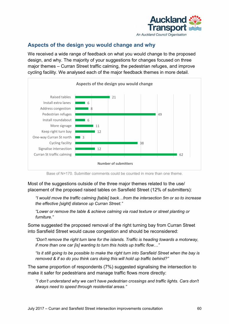
July 2017 – Curran and Sarsfield Street intersection improvements consultation 60
Aspects of the design you would change and why We received a wide range of feedback on what you would change to the proposed design, and why. The majority of your suggestions for changes focused on three major themes – Curran Street traffic calming, the pedestrian refuges, and improve cycling facility. We analysed each of the major feedback themes in more detail.
Base of N=170. Submitter comments could be counted in more than one theme.
Most of the suggestions outside of the three major themes related to the use/ placement of the proposed raised tables on Sarsfield Street (12% of submitters):
“I would move the traffic calming [table] back…from the intersection 5m or so to increase the effective [sight] distance up Curran Street.”
“Lower or remove the table & achieve calming via road texture or street planting or furniture.”
Some suggested the proposed removal of the right turning bay from Curran Street into Sarsfield Street would cause congestion and should be reconsidered:
“Don't remove the right turn lane for the islands. Traffic is heading towards a motorway, if more than one car [is] wanting to turn this holds up traffic flow…”
“Is it still going to be possible to make the right turn into Sarsfield Street when the bay is removed & if so do you think cars doing this will hold up traffic behind?”
The same proportion of respondents (7%) suggested signalising the intersection to make it safer for pedestrians and manage traffic flows more directly:
“I don’t understand why we can't have pedestrian crossings and traffic lights. Cars don't always need to speed through residential areas.”
62
12
38
3
12
11
6
49
8
6
21
Curran St traffic calming
Signalise intersection
Cycling facility
One-way Curran St north
Keep right turn bay
More signage
Install roundabout
Pedestrian refuges
Address congestion
Install extra lanes
Raised tables
Number of submitters
Aspects of the design you would change
July 2017 – Curran and Sarsfield Street intersection improvements consultation 61
“Add lights instead of an island…lights will slow the car down (or stop it) and make it safer for people to cross.”
A smaller proportion suggested changes to signage to, encourage motorists to slow down or modify their behaviour around the intersection:
“Add an electronic, flashing "SLOW" sign visible to traffic approaching the intersection along Sarsfield.”
“[I’d] like to see a sign on Curran St warning traffic that there's a 'Busy Intersection Ahead. Slow Down'.”
“I'd move the 'school zone ends' sign [until] after the intersection…”
Some felt the proposed design may cause congestion for a variety of reasons, and offered solutions to their concerns.
“Pedestrian refuge on Curran St (lower)…could cause unnecessary congestion for traffic queuing for the Harbour Bridge.”
“Ensure two vehicles’ width at Sarsfield Street East so one can turn left whist one turns right.”
Six submitters suggested a roundabout as an alternative to manage traffic from all directions, heading into and exiting the intersection. Three suggested one-waying Curran Street north of the Sarsfield Street intersection and down to the on-ramp.
“Intersection should have a roundabout with compulsory stops from all roads…to stop Curran Street traffic blocking Sarsfield Street and compounding congestion.”
“One-waying Curran Street/ Beach Road was suggested to accommodate cycle lanes and reduce traffic volumes.”
Curran Street traffic calming suggestions
The largest proportion of all respondents (36%) made suggestions to introduce more traffic calming on Curran Street. The majority of these were general suggestions with no specific or preferred solution given:
“Be more aggressive with your approach to speed management on Curran St.”
“Cars routinely speed down Curran St heading for the motorway onramp. Anything to reduce speed here would be welcome.”
“There needs to be some way of slowing the traffic down the Curran Street hill - there are often crashes on the corner of Curran/Sarsfield.”
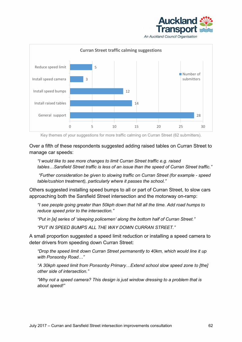
July 2017 – Curran and Sarsfield Street intersection improvements consultation 62
Key themes of your suggestions for more traffic calming on Curran Street (62 submitters).
Over a fifth of these respondents suggested adding raised tables on Curran Street to manage car speeds:
“I would like to see more changes to limit Curran Street traffic e.g. raised tables…Sarsfield Street traffic is less of an issue than the speed of Curran Street traffic.”
“Further consideration be given to slowing traffic on Curran Street (for example - speed table/cushion treatment), particularly where it passes the school.”
Others suggested installing speed bumps to all or part of Curran Street, to slow cars approaching both the Sarsfield Street intersection and the motorway on-ramp:
“I see people going greater than 50kph down that hill all the time. Add road humps to reduce speed prior to the intersection.”
“Put in [a] series of ‘sleeping policemen’ along the bottom half of Curran Street.”
“PUT IN SPEED BUMPS ALL THE WAY DOWN CURRAN STREET.”
A small proportion suggested a speed limit reduction or installing a speed camera to deter drivers from speeding down Curran Street:
“Drop the speed limit down Curran Street permanently to 40km, which would line it up with Ponsonby Road…”
“A 30kph speed limit from Ponsonby Primary…Extend school slow speed zone to [the] other side of intersection.”
“Why not a speed camera? This design is just window dressing to a problem that is about speed!”
28
14
12
3
5
General support
Install raised tables
Install speed bumps
Install speed camera
Reduce speed limit
0 5 10 15 20 25 30
Curran Street traffic calming suggestions
Number ofsubmitters
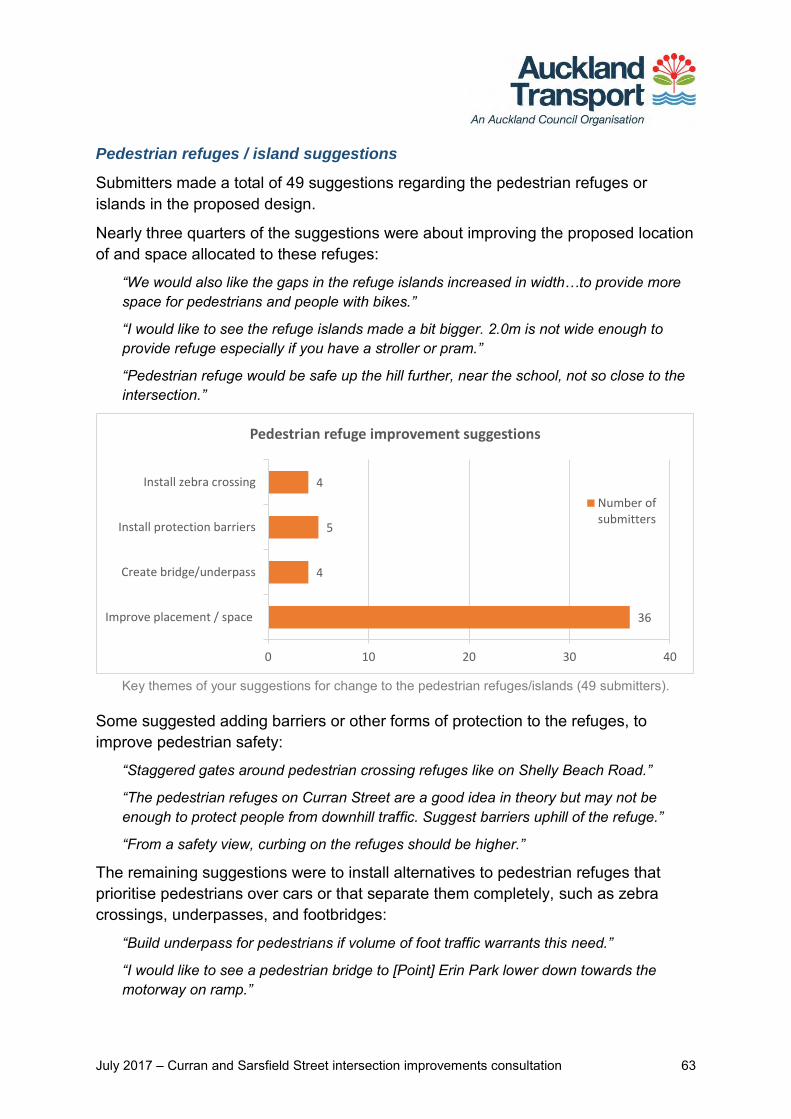
July 2017 – Curran and Sarsfield Street intersection improvements consultation 63
Pedestrian refuges / island suggestions
Submitters made a total of 49 suggestions regarding the pedestrian refuges or islands in the proposed design.
Nearly three quarters of the suggestions were about improving the proposed location of and space allocated to these refuges:
“We would also like the gaps in the refuge islands increased in width…to provide more space for pedestrians and people with bikes.”
“I would like to see the refuge islands made a bit bigger. 2.0m is not wide enough to provide refuge especially if you have a stroller or pram.”
“Pedestrian refuge would be safe up the hill further, near the school, not so close to the intersection.”
Key themes of your suggestions for change to the pedestrian refuges/islands (49 submitters).
Some suggested adding barriers or other forms of protection to the refuges, to improve pedestrian safety:
“Staggered gates around pedestrian crossing refuges like on Shelly Beach Road.”
“The pedestrian refuges on Curran Street are a good idea in theory but may not be enough to protect people from downhill traffic. Suggest barriers uphill of the refuge.”
“From a safety view, curbing on the refuges should be higher.”
The remaining suggestions were to install alternatives to pedestrian refuges that prioritise pedestrians over cars or that separate them completely, such as zebra crossings, underpasses, and footbridges:
“Build underpass for pedestrians if volume of foot traffic warrants this need.”
“I would like to see a pedestrian bridge to [Point] Erin Park lower down towards the motorway on ramp.”
36
4
5
4
Improve placement / space
Create bridge/underpass
Install protection barriers
Install zebra crossing
0 10 20 30 40
Pedestrian refuge improvement suggestions
Number ofsubmitters
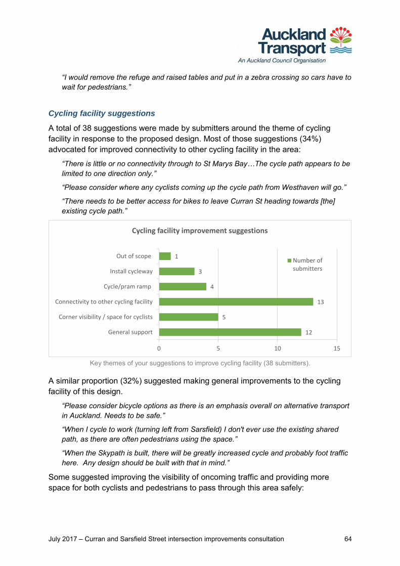
July 2017 – Curran and Sarsfield Street intersection improvements consultation 64
“I would remove the refuge and raised tables and put in a zebra crossing so cars have to wait for pedestrians.”
Cycling facility suggestions
A total of 38 suggestions were made by submitters around the theme of cycling facility in response to the proposed design. Most of those suggestions (34%) advocated for improved connectivity to other cycling facility in the area:
“There is little or no connectivity through to St Marys Bay…The cycle path appears to be limited to one direction only.”
“Please consider where any cyclists coming up the cycle path from Westhaven will go.”
“There needs to be better access for bikes to leave Curran St heading towards [the] existing cycle path.”
Key themes of your suggestions to improve cycling facility (38 submitters).
A similar proportion (32%) suggested making general improvements to the cycling facility of this design.
“Please consider bicycle options as there is an emphasis overall on alternative transport in Auckland. Needs to be safe.”
“When I cycle to work (turning left from Sarsfield) I don't ever use the existing shared path, as there are often pedestrians using the space.”
“When the Skypath is built, there will be greatly increased cycle and probably foot traffic here. Any design should be built with that in mind.”
Some suggested improving the visibility of oncoming traffic and providing more space for both cyclists and pedestrians to pass through this area safely:
12
5
13
4
3
1
General support
Corner visibility / space for cyclists
Connectivity to other cycling facility
Cycle/pram ramp
Install cycleway
Out of scope
0 5 10 15
Cycling facility improvement suggestions
Number ofsubmitters
July 2017 – Curran and Sarsfield Street intersection improvements consultation 65
“Add a mirror or something similar to north-west corner [of the intersection] for visibility for cyclists and walkers. Cyclists coming from Sarsfield St west cannot see what traffic or pedestrians are coming…”
“It's a blind corner. Diverting cycle lanes onto footpath is dangerous.”
“The shared cyclist/pedestrian path down to the harbour is too narrow for safe cycling…I would prefer bike lanes on the road…”
Some suggested modifications to the cycle and pram ramps, to help those on wheels to make safer, smoother transitions from one surface to another.
“It would also be nice to have a smooth ramp for cyclists when they are coming down Curran Street and transitioning onto the shared foot/cycle path from the road.”
“If there could be a kerb drop between the pram crossings on the lower/western side of Sarsfield, and the western side of Curran…so that you can access the shared path by bike after coming down Curran St on your bike.”
One submitter’s suggestion fell outside of the scope of this proposed design.
“Get rid of the yellow and black speed bump going into Westhaven, it’s dangerous for bikes and the footpath is too narrow for bunches of cyclists.”
Other comments or concerns In response to the final question, submitters shared 43 comments or concerns about the proposed intersection design. A number of comments related to parking – some advocated for the removal of parking on these streets, and others expressed concern for potential loss of parking space.
“I…strongly object to car parking on Sarsfield Street, it restricts parking for ratepayers on our streets [and] blocks access.”
“I am against current parking places being removed. There is more & more building & less & less parking in the area.”
“The narrowing also removes parking area which is already at a premium.”
A few concerns were raised about both existing and proposed plantings, and how they might impact peoples’ visibility in and around the intersection.
“Please ensure that the planted area has small shrubs or ground cover so that oncoming traffic, bike, pedestrians aren't obscured.”
“Taking down trees (etc.) which are in line with [oncoming] vehicles in all directions… keeping them trimmed back is essential.”
Some submitters had concerns about the level of traffic calming proposed for Sarsfield Street East, suggesting that more measures were needed.
July 2017 – Curran and Sarsfield Street intersection improvements consultation 66
“There needs to be more to moderate the traffic speed on Sarsfield Street between Shelley Beach Road and Curran Street.”
“Traffic from west to east on Sarsfield St is minimal but the traffic travelling from east to west is busy, they think it’s a faster option than going to top of Shelley Beach Rd.”
Two submitters commented on the timing of works on the final design – when it should take place, and speed of completion.
“Only the delays/disruption caused during construction. Please try and do majority of this in school holidays. Perhaps coincide it with the Curran Street on-ramp.”
“Just triple the workmen and get it done in a third of the time. I am sick of being mired in roadworks around the city.
The majority of comments (24 in total) covered no specific theme and ranged from questions about the proposed design to comments on the consultation process, and references to other problem areas outside the scope of this proposal.
“This work should have priority. A cyclist has already very nearly been killed in Sarsfield Street recently & intersections with Sarsfield & Hamilton is dangerous.”
“Great to be consulted in such an easy manner.”
“How has this been prioritised above the need for traffic lights at the Parawai/Richmond Road intersection?”
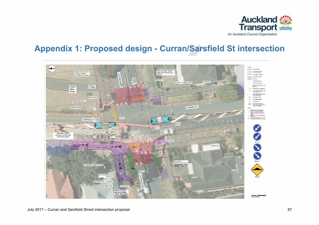
July 2017 – Curran and Sarsfield Street intersection proposal 67
Appendix 1: Proposed design - Curran/Sarsfield St intersection
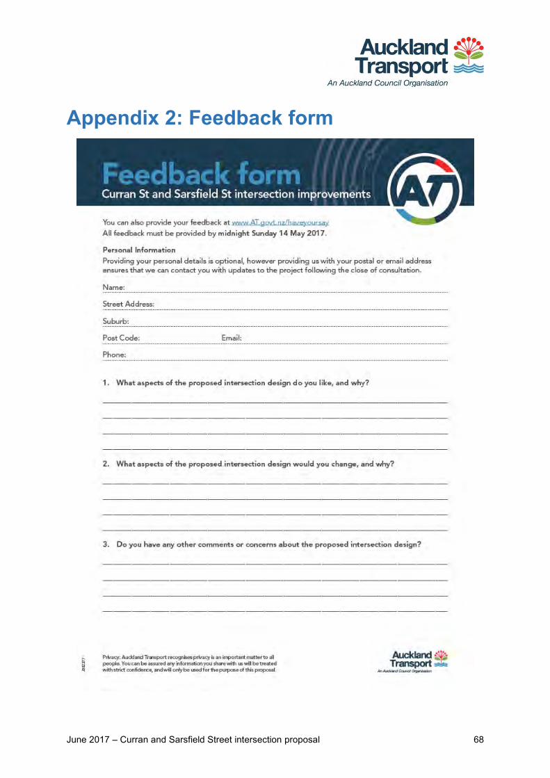
June 2017 – Curran and Sarsfield Street intersection proposal 68
Appendix 2: Feedback form
July 2017 – Curran and Sarsfield Street intersection proposal 69
Appendix 3: Key themes and submitter comments with AT responses
Theme Number of submitters Feedback points included in theme AT response
General sentiment
Generally support the design
48
Fully support the proposed design Net effect of proposed treatments will make this busy intersection safer for all
users - Traffic flow maintained - Addresses pedestrians, cyclists, and motorists alike
Thanks for your comments.
Don’t like the proposed design
21
Not enough focus on slowing traffic or managing traffic flows on Curran Street Pedestrian refuges and pram ramps encourage people to cross an unsafe road - Refuges offer no barriers or protection to pedestrians from speeding cars Pedestrians may block visibility of cars coming from Pt Erin on Sarsfield Street
Thanks for your feedback. The proposed improvements to the Curran and Sarsfield Street intersection will make intersection safer for pedestrians, people on bikes and motorists. New speed tables on the eastern and western sides of the Sarsfield Street will help to reduce traffic speed and signal to drivers that they are entering a lower speed environment. These speed tables also provide a pedestrian crossing point thus improving connections to Point Erin park for pedestrians and people on bikes. Pedestrian refuges and pram crossings provide crossing points which are safe which motorists will comply with. Please note that visibility and sightline checks will be done during next stage which is detailed design phase. Appropriate measure will be taken where visibility becomes an issue.
July 2017 – Curran and Sarsfield Street intersection proposal 70
Theme Number of submitters Feedback points included in theme AT response
Post implementation / construction – Auckland Transport will monitor the traffic operations on Curran St. Further investigation and improvements will be undertaken and implemented as necessary.
Aspects of the design that you liked
Will slow traffic 26
Raised tables on east and west ends of Sarsfield Street will slow traffic down Pedestrian refuge / island will slow traffic coming down the hill on Curran Street Will discourage motorway traffic coming up Curran St from speeding into
Sarsfield St
Thanks for your feedback.
Raised tables 23
Raised tables an effective way to slow traffic overall - Support for their use to slow cars on Sarsfield Street in particular - Dampens use of this street to ‘rat race’ to the northbound motorway on-ramp Designed to support foot traffic; provide safety controls for all pedestrians
Thanks for your feedback.
Wider footpaths 6 Support for widened footpath on the north-west corner of the intersection - Enables better shared use of this busy path – space for pedestrians, cyclists,
and possible future cycle paths - Combined with raised table to the west, provides more tenable solution.
Thanks for your feedback
Pedestrian refuges / islands 59
Provides protection to pedestrians crossing near this intersection, particularly - School children before and after school - People walking from Sarsfield St across to Pt Erin
Refuges / islands also act as traffic calming element on Curran Street However barriers similar to those on Shelley Beach Rd also suggested for better
pedestrian safety and refuge to those waiting in the middle of the road to cross.
Thanks for your feedback. Provision to install handrail barrier protection on the central refuges/islands similar to Shelly Beach Rd will be investigated during Detail Design stage.
Shared path / footpath 19
Support for this shared, wider path as long as it is clearly marked for both pedestrians and cyclists
Potentially safer for cyclists coming up the hill and turning into west Sarsfield St.
Thanks for your feedback.
July 2017 – Curran and Sarsfield Street intersection proposal 71
Theme Number of submitters Feedback points included in theme AT response
Removing right turn 1
Supports the removal of the right hand turn from Curran St into Sarsfield St. Thanks for your comments.
Suggestions for design changes
Do more to slow traffic on Curran Street
62
General desire to see more traffic calming measures introduced to Curran Street
- Cars speeding downhill toward the motorway on Curran Street seen as a big contributing factor to poor safety at this intersection
- Proposed design does not do enough to slow traffic on this street in its entirety.
Thanks for your feedback. The focus of the proposal is to make safety improvements at the Curran St and Sarsfield St intersection and enhance pedestrian crossing facilities. The design is intended to slow traffic speed when approaching the intersection. Post implementation – Auckland Transport will monitor the traffic operations on Curran St. Further investigation and improvements will be undertaken and implemented as necessary.
Add raised tables to Curran Street - Continuity with proposed raised tables on Sarsfield St for traffic calming - Install on both sides of Curran Street to slow both motorway-bound traffic and
cars coming uphill / approaching intersection
Thanks for your feedback. During investigation, provision to install raised speed tables on Curran St was assessed. However, it has been discounted due to traffic flow/operational requirement on Curran St which provides direct connection to the Harbour Bridge on-ramp and currently serves as secondary arterial road. Post implementation/construction – Auckland Transport will monitor the traffic flow /operations on Curran St. Further treatments (i.e. speed cushion and others) will be implemented as necessary.
Add speed bumps to Curran Street - All the way down the street; prevent speeding down the street’s entirety - At the bottom of Curran St, to dampen speed of cars heading to the on-ramp
Thanks for your feedback. Post implementation – Auckland Transport will monitor the traffic operations on
July 2017 – Curran and Sarsfield Street intersection proposal 72
Theme Number of submitters Feedback points included in theme AT response
Curran St. Further treatments (i.e. speed cushion and others) will be implemented as necessary.
Reduce the speed limit on Curran Street - Extend 40km/hr zone from Ponsonby Primary School downhill to the far side of
the Curran/Sarsfield St intersection - Suggestion to also reduce this zone down to 30 km/hr
Thanks for your feedback. Changes to speed limits across a wide area would need approval at a national level; however, in many cases a reduction in speed can be achieved through design, and this is generally more effective than a simple speed limit change. The general approach for local residential streets on the proposed network will be to reduce speed by designing a slow speed environment rather than introducing a speed limit in isolation.
Install speed camera on Curran Street - Pointing up from the bottom of Curran St to discourage uphill/downhill traffic
heading toward the motorway on-ramp or this intersection - May negate the need to install other traffic calming measures
With regard to speed cameras this is a programme funded by New Zealand Transport Agency (NZTA) and run by the Police. We have only limited input in reviewing the sites they select. The speed camera programme for static camera sites is prioritised nationwide based primarily on speed related crash risk. Mobile speed camera enforcement is prioritised by the police at district level and while they have greater discretion on where to deploy the cameras this is still generally targeted to where there is a combination of speed related crash risk and poor compliance with the posted limits.
Signalise intersection 12
Add a set of traffic lights to this intersection instead of pedestrian refuge / island - Manage the movement of cars around this intersection more directly - Give pedestrians a safer means to cross the street, with cars signalled to stop
Thanks for your feedback. During investigation, installing traffic signals at this intersection was assessed. However, since the intersection is located at close proximity to the harbour bridge on-ramp and to the existing traffic signal located in front of Ponsonby Primary School – the provision to add
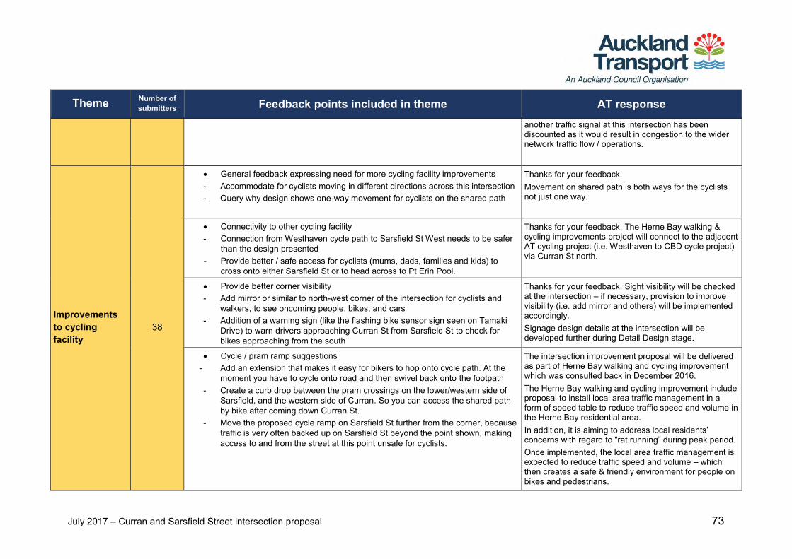
July 2017 – Curran and Sarsfield Street intersection proposal 73
Theme Number of submitters Feedback points included in theme AT response
another traffic signal at this intersection has been discounted as it would result in congestion to the wider network traffic flow / operations.
Improvements to cycling facility
38
General feedback expressing need for more cycling facility improvements - Accommodate for cyclists moving in different directions across this intersection - Query why design shows one-way movement for cyclists on the shared path
Thanks for your feedback. Movement on shared path is both ways for the cyclists not just one way.
Connectivity to other cycling facility - Connection from Westhaven cycle path to Sarsfield St West needs to be safer
than the design presented - Provide better / safe access for cyclists (mums, dads, families and kids) to
cross onto either Sarsfield St or to head across to Pt Erin Pool.
Thanks for your feedback. The Herne Bay walking & cycling improvements project will connect to the adjacent AT cycling project (i.e. Westhaven to CBD cycle project) via Curran St north.
Provide better corner visibility - Add mirror or similar to north-west corner of the intersection for cyclists and
walkers, to see oncoming people, bikes, and cars - Addition of a warning sign (like the flashing bike sensor sign seen on Tamaki
Drive) to warn drivers approaching Curran St from Sarsfield St to check for bikes approaching from the south
Thanks for your feedback. Sight visibility will be checked at the intersection – if necessary, provision to improve visibility (i.e. add mirror and others) will be implemented accordingly. Signage design details at the intersection will be developed further during Detail Design stage.
Cycle / pram ramp suggestions - Add an extension that makes it easy for bikers to hop onto cycle path. At the
moment you have to cycle onto road and then swivel back onto the footpath - Create a curb drop between the pram crossings on the lower/western side of
Sarsfield, and the western side of Curran. So you can access the shared path by bike after coming down Curran St.
- Move the proposed cycle ramp on Sarsfield St further from the corner, because traffic is very often backed up on Sarsfield St beyond the point shown, making access to and from the street at this point unsafe for cyclists.
The intersection improvement proposal will be delivered as part of Herne Bay walking and cycling improvement which was consulted back in December 2016. The Herne Bay walking and cycling improvement include proposal to install local area traffic management in a form of speed table to reduce traffic speed and volume in the Herne Bay residential area. In addition, it is aiming to address local residents’ concerns with regard to “rat running” during peak period. Once implemented, the local area traffic management is expected to reduce traffic speed and volume – which then creates a safe & friendly environment for people on bikes and pedestrians.
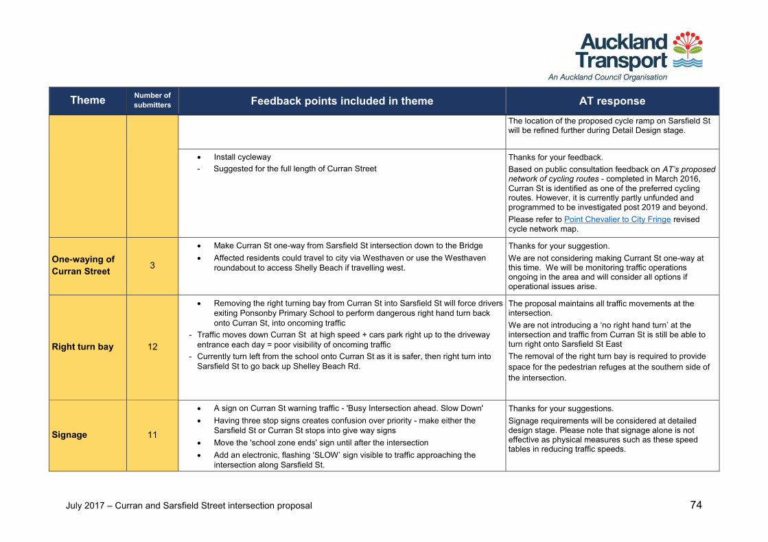
July 2017 – Curran and Sarsfield Street intersection proposal 74
Theme Number of submitters Feedback points included in theme AT response
The location of the proposed cycle ramp on Sarsfield St will be refined further during Detail Design stage.
Install cycleway - Suggested for the full length of Curran Street
Thanks for your feedback. Based on public consultation feedback on AT’s proposed network of cycling routes - completed in March 2016, Curran St is identified as one of the preferred cycling routes. However, it is currently partly unfunded and programmed to be investigated post 2019 and beyond. Please refer to Point Chevalier to City Fringe revised cycle network map.
One-waying of Curran Street 3
Make Curran St one-way from Sarsfield St intersection down to the Bridge Affected residents could travel to city via Westhaven or use the Westhaven
roundabout to access Shelly Beach if travelling west.
Thanks for your suggestion. We are not considering making Currant St one-way at this time. We will be monitoring traffic operations ongoing in the area and will consider all options if operational issues arise.
Right turn bay 12
Removing the right turning bay from Curran St into Sarsfield St will force drivers exiting Ponsonby Primary School to perform dangerous right hand turn back onto Curran St, into oncoming traffic
- Traffic moves down Curran St at high speed + cars park right up to the driveway entrance each day = poor visibility of oncoming traffic
- Currently turn left from the school onto Curran St as it is safer, then right turn into Sarsfield St to go back up Shelley Beach Rd.
The proposal maintains all traffic movements at the intersection. We are not introducing a ‘no right hand turn’ at the intersection and traffic from Curran St is still be able to turn right onto Sarsfield St East The removal of the right turn bay is required to provide space for the pedestrian refuges at the southern side of the intersection.
Signage 11
A sign on Curran St warning traffic - 'Busy Intersection ahead. Slow Down' Having three stop signs creates confusion over priority - make either the
Sarsfield St or Curran St stops into give way signs Move the 'school zone ends' sign until after the intersection Add an electronic, flashing ‘SLOW’ sign visible to traffic approaching the
intersection along Sarsfield St.
Thanks for your suggestions. Signage requirements will be considered at detailed design stage. Please note that signage alone is not effective as physical measures such as these speed tables in reducing traffic speeds.
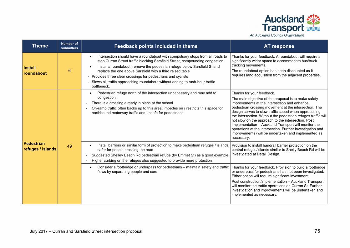
July 2017 – Curran and Sarsfield Street intersection proposal 75
Theme Number of submitters Feedback points included in theme AT response
Install roundabout 6
Intersection should have a roundabout with compulsory stops from all roads to stop Curran Street traffic blocking Sarsfield Street, compounding congestion.
Install a roundabout, remove the pedestrian refuge below Sarsfield St and replace the one above Sarsfield with a third raised table
- Provides three clear crossings for pedestrians and cyclists - Slows all traffic approaching roundabout without adding to rush-hour traffic
bottleneck.
Thanks for your feedback. A roundabout will require a significantly wider space to accommodate bus/truck tracking movements. The roundabout option has been discounted as it requires land acquisition from the adjacent properties.
Pedestrian refuges / islands 49
Pedestrian refuge north of the intersection unnecessary and may add to congestion
- There is a crossing already in place at the school - On-ramp traffic often backs up to this area; impedes on / restricts this space for
northbound motorway traffic and unsafe for pedestrians
Thanks for your feedback. The main objective of the proposal is to make safety improvements at the intersection and enhance pedestrian crossing movement at the intersection. The design serves to slow traffic speed when approaching the intersection. Without the pedestrian refuges traffic will not slow on the approach to the intersection. Post implementation – Auckland Transport will monitor the operations at the intersection. Further investigation and improvements (will be undertaken and implemented as necessary.
Install barriers or similar form of protection to make pedestrian refuges / islands safer for people crossing the road
- Suggested Shelley Beach Rd pedestrian refuge (by Emmet St) as a good example - Higher curbing on the refuges also suggested to provide more protection
Provision to install handrail barrier protection on the central refuges/islands similar to Shelly Beach Rd will be investigated at Detail Design.
Consider a footbridge or underpass for pedestrians – maintain safety and traffic flows by separating people and cars
Thanks for your feedback. Provision to build a footbridge or underpass for pedestrians has not been investigated. Either option will require significant investment. Post construction/implementation – Auckland Transport will monitor the traffic operations on Curran St. Further investigation and improvements will be undertaken and implemented as necessary.
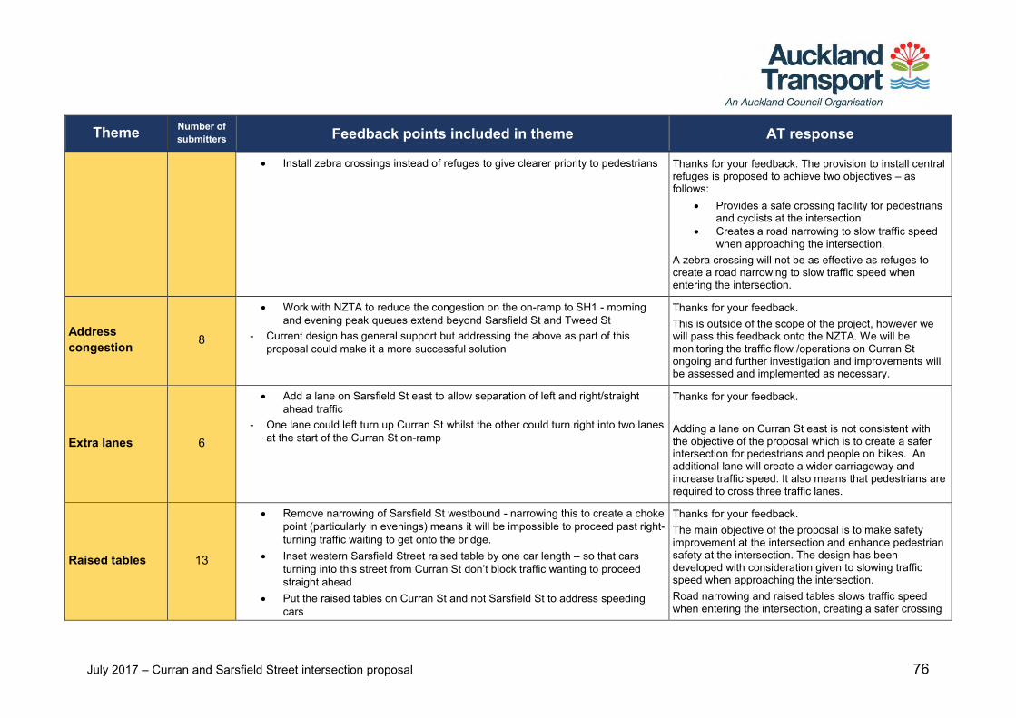
July 2017 – Curran and Sarsfield Street intersection proposal 76
Theme Number of submitters Feedback points included in theme AT response
Install zebra crossings instead of refuges to give clearer priority to pedestrians Thanks for your feedback. The provision to install central refuges is proposed to achieve two objectives – as follows:
Provides a safe crossing facility for pedestrians and cyclists at the intersection
Creates a road narrowing to slow traffic speed when approaching the intersection.
A zebra crossing will not be as effective as refuges to create a road narrowing to slow traffic speed when entering the intersection.
Address congestion 8
Work with NZTA to reduce the congestion on the on-ramp to SH1 - morning and evening peak queues extend beyond Sarsfield St and Tweed St
- Current design has general support but addressing the above as part of this proposal could make it a more successful solution
Thanks for your feedback. This is outside of the scope of the project, however we will pass this feedback onto the NZTA. We will be monitoring the traffic flow /operations on Curran St ongoing and further investigation and improvements will be assessed and implemented as necessary.
Extra lanes 6
Add a lane on Sarsfield St east to allow separation of left and right/straight ahead traffic
- One lane could left turn up Curran St whilst the other could turn right into two lanes at the start of the Curran St on-ramp
Thanks for your feedback. Adding a lane on Curran St east is not consistent with the objective of the proposal which is to create a safer intersection for pedestrians and people on bikes. An additional lane will create a wider carriageway and increase traffic speed. It also means that pedestrians are required to cross three traffic lanes.
Raised tables 13
Remove narrowing of Sarsfield St westbound - narrowing this to create a choke point (particularly in evenings) means it will be impossible to proceed past right-turning traffic waiting to get onto the bridge.
Inset western Sarsfield Street raised table by one car length – so that cars turning into this street from Curran St don’t block traffic wanting to proceed straight ahead
Put the raised tables on Curran St and not Sarsfield St to address speeding cars
Thanks for your feedback. The main objective of the proposal is to make safety improvement at the intersection and enhance pedestrian safety at the intersection. The design has been developed with consideration given to slowing traffic speed when approaching the intersection. Road narrowing and raised tables slows traffic speed when entering the intersection, creating a safer crossing
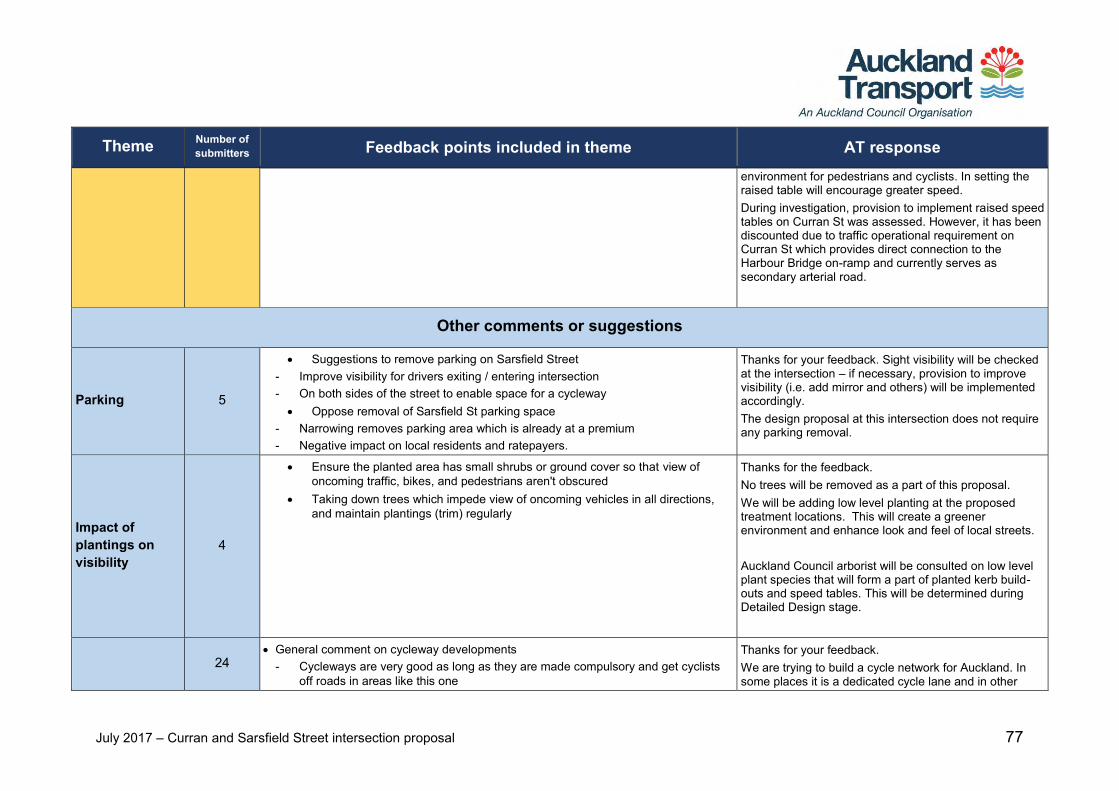
July 2017 – Curran and Sarsfield Street intersection proposal 77
Theme Number of submitters Feedback points included in theme AT response
environment for pedestrians and cyclists. In setting the raised table will encourage greater speed. During investigation, provision to implement raised speed tables on Curran St was assessed. However, it has been discounted due to traffic operational requirement on Curran St which provides direct connection to the Harbour Bridge on-ramp and currently serves as secondary arterial road.
Other comments or suggestions
Parking 5
Suggestions to remove parking on Sarsfield Street - Improve visibility for drivers exiting / entering intersection - On both sides of the street to enable space for a cycleway Oppose removal of Sarsfield St parking space
- Narrowing removes parking area which is already at a premium - Negative impact on local residents and ratepayers.
Thanks for your feedback. Sight visibility will be checked at the intersection – if necessary, provision to improve visibility (i.e. add mirror and others) will be implemented accordingly. The design proposal at this intersection does not require any parking removal.
Impact of plantings on visibility
4
Ensure the planted area has small shrubs or ground cover so that view of oncoming traffic, bikes, and pedestrians aren't obscured
Taking down trees which impede view of oncoming vehicles in all directions, and maintain plantings (trim) regularly
Thanks for the feedback. No trees will be removed as a part of this proposal. We will be adding low level planting at the proposed treatment locations. This will create a greener environment and enhance look and feel of local streets. Auckland Council arborist will be consulted on low level plant species that will form a part of planted kerb build-outs and speed tables. This will be determined during Detailed Design stage.
24 General comment on cycleway developments
- Cycleways are very good as long as they are made compulsory and get cyclists off roads in areas like this one
Thanks for your feedback. We are trying to build a cycle network for Auckland. In some places it is a dedicated cycle lane and in other
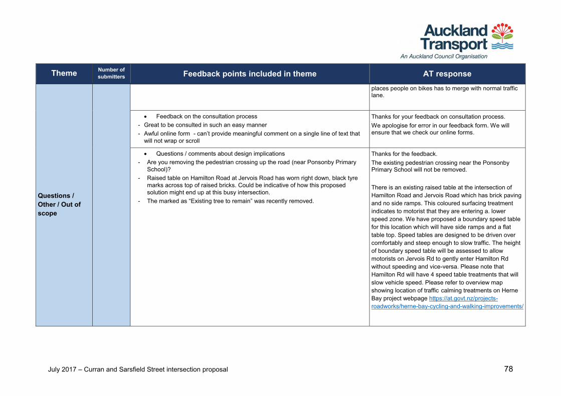
July 2017 – Curran and Sarsfield Street intersection proposal 78
Theme Number of submitters Feedback points included in theme AT response
Questions / Other / Out of scope
places people on bikes has to merge with normal traffic lane.
Feedback on the consultation process - Great to be consulted in such an easy manner - Awful online form - can’t provide meaningful comment on a single line of text that
will not wrap or scroll
Thanks for your feedback on consultation process. We apologise for error in our feedback form. We will ensure that we check our online forms.
Questions / comments about design implications - Are you removing the pedestrian crossing up the road (near Ponsonby Primary
School)? - Raised table on Hamilton Road at Jervois Road has worn right down, black tyre
marks across top of raised bricks. Could be indicative of how this proposed solution might end up at this busy intersection.
- The marked as “Existing tree to remain” was recently removed.
Thanks for the feedback. The existing pedestrian crossing near the Ponsonby Primary School will not be removed. There is an existing raised table at the intersection of Hamilton Road and Jervois Road which has brick paving and no side ramps. This coloured surfacing treatment indicates to motorist that they are entering a. lower speed zone. We have proposed a boundary speed table for this location which will have side ramps and a flat table top. Speed tables are designed to be driven over comfortably and steep enough to slow traffic. The height of boundary speed table will be assessed to allow motorists on Jervois Rd to gently enter Hamilton Rd without speeding and vice-versa. Please note that Hamilton Rd will have 4 speed table treatments that will slow vehicle speed. Please refer to overview map showing location of traffic calming treatments on Herne Bay project webpage https://at.govt.nz/projects-roadworks/herne-bay-cycling-and-walking-improvements/
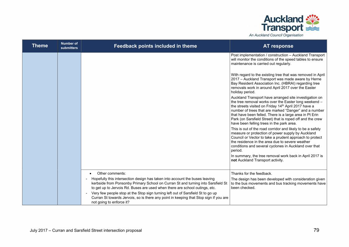
July 2017 – Curran and Sarsfield Street intersection proposal 79
Theme Number of submitters Feedback points included in theme AT response
Post implementation / construction – Auckland Transport will monitor the conditions of the speed tables to ensure maintenance is carried out regularly. With regard to the existing tree that was removed in April 2017 – Auckland Transport was made aware by Herne Bay Resident Association Inc. (HBRAI) regarding tree removals work in around April 2017 over the Easter holiday period. Auckland Transport have arranged site investigation on the tree removal works over the Easter long weekend – the streets visited on Friday 14th April 2017 have a number of trees that are marked “Danger” and a number that have been felled. There is a large area in Pt Erin Park (on Sarsfield Street) that is roped off and the crew have been felling trees in the park area. This is out of the road corridor and likely to be a safety measure or protection of power supply by Auckland Council or Vector to take a prudent approach to protect the residence in the area due to severe weather conditions and several cyclones in Auckland over that period. In summary, the tree removal work back in April 2017 is not Auckland Transport activity.
Other comments: - Hopefully this intersection design has taken into account the buses leaving
kerbside from Ponsonby Primary School on Curran St and turning into Sarsfield St to get up to Jervois Rd. Buses are used when there are school outings, etc.
- Very few people stop at the Stop sign turning left out of Sarsfield St to go up Curran St towards Jervois, so is there any point in keeping that Stop sign if you are not going to enforce it?
Thanks for the feedback. The design has been developed with consideration given to the bus movements and bus tracking movements have been checked.