Embed Size (px)
Citation preview

February 26, 2009February 26, 2009
Aviation Weather Center Aviation Weather Center Pat Murphy WCMPat Murphy WCM
The trusted authority and leading innovator for aviation weather information.

MissionMission
The AWC deliversThe AWC delivers
consistent, timely and accurateconsistent, timely and accurateweather informationweather information
for the world airspace systemfor the world airspace system
We are a team of highly skilled peopleWe are a team of highly skilled peoplededicated to working withdedicated to working with
customers and partnerscustomers and partnersto enhance safe and efficient flightto enhance safe and efficient flight

Weather for theWeather for theNational Airspace System (NAS)National Airspace System (NAS)
AWCAWC Issues all enroute aviation forecastsIssues all enroute aviation forecasts
clouds, visibility, turbulence, icing, thunderstorms, windclouds, visibility, turbulence, icing, thunderstorms, windexcept for terminal areas.except for terminal areas.
Weather Forecast Offices (WFO)Weather Forecast Offices (WFO)Main source of collaborated meso scale and synoptic WxMain source of collaborated meso scale and synoptic Wx Issue TAFsIssue TAFs
24 hour forecast for approx 610 airports24 hour forecast for approx 610 airports CWSUCWSU
Customized services for ARTCCCustomized services for ARTCCSupplements some of AWC’s forecastsSupplements some of AWC’s forecasts

AWC’s CustomersAWC’s Customers
CWSUsCWSUs WFOsWFOs FAA Air Traffic OperationsFAA Air Traffic Operations Flight Service StationsFlight Service Stations Domestic and International Airlines, Charter, Domestic and International Airlines, Charter,
CorporateCorporate Gulf of Mexico’s oil industry (helicopter Gulf of Mexico’s oil industry (helicopter
operations)operations) General AviationGeneral Aviation MilitaryMilitary Worldwide users of AWC website (ADDS)Worldwide users of AWC website (ADDS)

Forecaster Scheduled Products by Forecaster Scheduled Products by NCEP Service Center by MonthNCEP Service Center by Month
Monthly number of forecaster issued products by NCEP Service CentersTotal is 25,380
CPC, 650, 3%HPC, 5100, 20%
OPC, 4590, 18%
SPC, 1380, 5%
SWPC, 400, 2%
TPC, 3360, 13%
AWC, 9900, 39%
AWC
CPC
HPC
OPC
SPC
SWPC
TPC
DOMESTIC OPERATIONSDOMESTIC OPERATIONS

Area Forecasts (FA)Area Forecasts (FA)
Staffing: Staffing: 15 forecasters 24/715 forecasters 24/7 Simulating 6 officesSimulating 6 offices
Text-based Weather Text-based Weather Forecasts for General Forecasts for General Aviation Pilots.Aviation Pilots. Clouds (can’t say IFR)Clouds (can’t say IFR) Visibility (can’t say IFR)Visibility (can’t say IFR) ThunderstormsThunderstorms Rain/Snow/FogRain/Snow/Fog WindWind
Area of responsibility: Area of responsibility: CONUS and coastal CONUS and coastal waterswaters
6570 routine issues annually6570 routine issues annually
SYNOPSIS...AT 02Z LOW PRES NWRN MN WITH CDFNT BJI-PIR-DDY LN AND WRMFNT BJI-EAU-PMM LN. TROF FSD-TBE LN. BY 20Z LOW PRES CNTRL WI WITH CDFNT DLL-PWE-GLD LN AND WRMFNT DLL-ECK LN. ...DARRAH...
ND SCT100. OCNL BKN080 TOP FL180. ISOLD -SHRA. OTLK...VFR. .
SD WRN 1/3...SCT060 SCT120 TOP FL180. TIL 06-08Z OCNL CIG BKN050. WDLY SCT -SHRA/-TSRA. TS TOPS FL400. OTLK...VFR. CNTRL 1/3...SCT080. OCNL BKN060. WDLY SCT -SHRA ISOLD -TSRA. TS TOPS FL400. OTLK...VFR. ERN 1/3...SCT100. BY 05-07Z OCNL BKN080 TOP 160. OTLK...VFR SHRA. .
NE PNHNDL...AGL SCT050. TIL 04-06Z ISOLD -SHRA/-TSRA. TS TOPS FL400. OTLK...VFR. CNTRL AND E...AGL SCT040 BKN080 TOPS LYRD FL180. OCNL CIG OVC030. WDLY SCT -SHRA/-TSRA. TS TOPS FL450. TS POSS SEV. CNTRL BY 06-08Z SCT030 OCNL CIG BKN020. CONDS SPRDG ACRS RMNDR BY 11-13Z. OTLK...VFR. .

AIRMETsAIRMETs
WAUS1 KBOS 042032BOSS WA 042045AIRMET SIERRA UPDT 6 FOR IFR AND MTN OBSCN VALID UNTIL 050300AIRMET MTN OBSCN...ME NH VT NY PA MA MD WV VA FROM 70NW PQI TO MLT TO CON TO HAR TO 30NW GSO TO HMV TO HNN TO JHW TO SYR TO MSS TO YSC TO 70NW PQIMTNS OCNL OBSC IN CLDS/PCPN/BR. CONDS CONTG BYD 03Z THRU 09Z.
Staffing: Staffing: Same forecasters as SIGMETs/FASame forecasters as SIGMETs/FA
Non-thunderstorm weather not Non-thunderstorm weather not meeting SIGMET criteriameeting SIGMET criteria Moderate Icing, Moderate Icing,
Moderate Turbulence,Moderate Turbulence,
Widespread Areas ofWidespread Areas ofIFR i.e. Low Ceilings and Visibility,IFR i.e. Low Ceilings and Visibility,
Mountain ObscurationsMountain Obscurations
Strong Surface Wind Strong Surface Wind
Area of responsibility: Area of responsibility: CONUS and coastal watersCONUS and coastal waters
26280 routine issues annually26280 routine issues annually

Automated ProductsAutomated Products
Forecast Icing Potential (FIP)
Current Icing Product (CIP)
Graphical Turbulence Guidance (GTG)
National Convective Wx Forecast (NCWF)

ADDS Web SiteADDS Web Site
Aviation Digital Data Service (ADDS)Aviation Digital Data Service (ADDS)Developed by NCAR (AWRP funding)Developed by NCAR (AWRP funding)Operational 2003Operational 2003Averaging 10 million hits per day, 100 GB Averaging 10 million hits per day, 100 GB
per dayper dayhttp://adds.AviationWeather.govhttp://adds.AviationWeather.gov

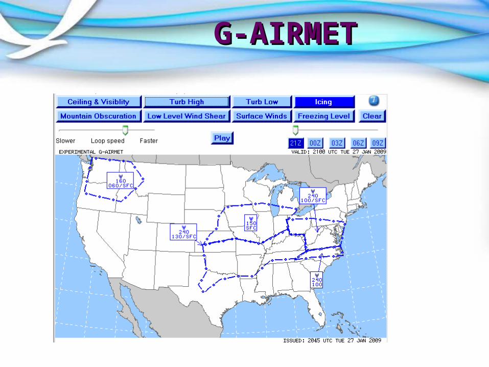
Graphical AIRMETGraphical AIRMETG-AIRMETG-AIRMET
G-AIRMET contains information related to the G-AIRMET contains information related to the occurrence or expected occurrence of en-route occurrence or expected occurrence of en-route weather phenomenon, which may affect safety of weather phenomenon, which may affect safety of aircraftaircraft
Issued at 03:00, 09:00, 15:00, and 21:00 UTCIssued at 03:00, 09:00, 15:00, and 21:00 UTCUpdates (e.g., amendments) issued as necessaryUpdates (e.g., amendments) issued as necessary
G-AIRMET provided in Binary Universal Format G-AIRMET provided in Binary Universal Format Record (BUFR) format via NWS operationRecord (BUFR) format via NWS operationDigital format intended for integration into customer Digital format intended for integration into customer
and partners’ systemsand partners’ systems Basic display interface on AviationWeather.govBasic display interface on AviationWeather.gov

ElementElement G-AIRMETG-AIRMET
TurbulenceTurbulence
(non-convective)(non-convective)
Moderate TurbulenceModerate Turbulence
Surface to 45,000 feetSurface to 45,000 feet
Sustained Surface WindsSustained Surface Winds ≥ ≥ 30 knots30 knots
Low Level Wind ShearLow Level Wind Shear
(non-convective)(non-convective)Wind shear (+/- 10 knots) below 2000 feetWind shear (+/- 10 knots) below 2000 feet AGL AGL
Surface VisibilitySurface Visibility≤≤ 3 miles3 miles
(IFR)(IFR)
Cause of Surface Cause of Surface Visibility restrictionVisibility restriction
Precipitation (PCPN), Mist (BR), Fog (FG), Precipitation (PCPN), Mist (BR), Fog (FG), Haze (HZ), Smoke (FU), Blowing Snow (BLSN)Haze (HZ), Smoke (FU), Blowing Snow (BLSN)
Low CeilingsLow CeilingsCeiling ≤Ceiling ≤ 1000 feet 1000 feet
(IFR)(IFR)
G-AIRMET ElementsG-AIRMET Elements
Some overlap with WFO and CWSU products

ElementElement G-AIRMETG-AIRMET
IcingIcing
(non-convective)(non-convective)
Moderate Airframe IcingModerate Airframe Icing
Surface to 45,000 feetSurface to 45,000 feet
Freezing LevelFreezing LevelLocation of the freezing level at the Surface, Location of the freezing level at the Surface,
4,000, 8,000, 12,000, and 16,0000 feet4,000, 8,000, 12,000, and 16,0000 feet
Multiple Freezing LevelsMultiple Freezing Levels Area and vertical rangeArea and vertical range
Mountain ObscurationMountain Obscuration AreaArea
Cause of Mountain Cause of Mountain ObscurationObscuration
Clouds (CLDS), Precipitation (PCPN), Clouds (CLDS), Precipitation (PCPN),
Mist (BR), Fog (FG), Haze (HZ), Smoke (FU)Mist (BR), Fog (FG), Haze (HZ), Smoke (FU)
SIGMETsSIGMETsIncluded in depiction but not provided as part of the G-Included in depiction but not provided as part of the G-
AIRMET/GFA BUFR messageAIRMET/GFA BUFR message
G-AIRMET Elements G-AIRMET Elements (Cont.)(Cont.)

G-AIRMETG-AIRMET
Intended to be displayed as a graphicIntended to be displayed as a graphic Not a text message converted to a graphicNot a text message converted to a graphic Data intended to be integrated into display systemsData intended to be integrated into display systems Not a “picture”Not a “picture”
Identification of weather hazardIdentification of weather hazard Use Lat/Long instead of VORsUse Lat/Long instead of VORs Uses many more points to describe with more precisionUses many more points to describe with more precision
Quality of informationQuality of information More precision in time and spaceMore precision in time and space More information than text can carryMore information than text can carry Tiny communication costsTiny communication costs

AIRMET and G-AIRMETAIRMET and G-AIRMET
The text AIRMET is a product of the The text AIRMET is a product of the G-AIRMETG-AIRMETAIRMET and G-AIRMET fully consistentAIRMET and G-AIRMET fully consistentThe AIRMET contains less precisionThe AIRMET contains less precisionAdvisory for a period of up to 6 hoursAdvisory for a period of up to 6 hours
a time “smear”a time “smear”The text AIRMET is limited by number of The text AIRMET is limited by number of
characterscharactersUses VORs to describe extent of hazard over a Uses VORs to describe extent of hazard over a
period of time.period of time.
G-AIRMETG-AIRMET

G-AIRMETG-AIRMET
Note: WFO and CWSU collaboration opportunities

Collaboration Collaboration AWC-WFO-CWSUAWC-WFO-CWSU
All three have unique as well as overlapping Aviation All three have unique as well as overlapping Aviation Weather responsibilityWeather responsibility
WFO 5mi radius – WFO 5mi radius – Approach/DepartureApproach/Departure Flight PlanningFlight Planning
AWC AWC Approach/Departure for all that is not a 5 mi circleApproach/Departure for all that is not a 5 mi circle Flight PlanningFlight Planning
CWSUCWSU TRACON – crucialTRACON – crucial
““bridge” between TAF and En-Route forecastbridge” between TAF and En-Route forecast

Collaboration OpportunitiesCollaboration Opportunities
FAA Continually states “weather information FAA Continually states “weather information consistency is favored over accuracy”. consistency is favored over accuracy”.
WFO NDFD gridsWFO NDFD grids Use for FA productionUse for FA production
WindsWinds Wind gustsWind gusts Cloud coverCloud cover WeatherWeather
Use for TAF productionUse for TAF production National Ceiling and Visibility National Ceiling and Visibility
Use as first guess or guidance for a GFE/NDFD grid Use as first guess or guidance for a GFE/NDFD grid population?population?

Area ForecastArea Forecast
FAUS43 KKCI FAUS43 KKCI 261045 FA3W 261045 FA3W CHIC FA 261045 CHIC FA 261045 SYNOPSIS AND VFR CLDS/WX SYNOPSIS VALID UNTIL SYNOPSIS AND VFR CLDS/WX SYNOPSIS VALID UNTIL
270500 270500 CLDS/WX VALID UNTIL 262300...OTLK VALID 262300-270500CLDS/WX VALID UNTIL 262300...OTLK VALID 262300-270500 ND SD NE KS MN IA MO WI LM LS MI LH IL IN KY . ND SD NE KS MN IA MO WI LM LS MI LH IL IN KY . SEE AIRMET SIERRA FOR IFR CONDS AND MTN OBSCN. TS SEE AIRMET SIERRA FOR IFR CONDS AND MTN OBSCN. TS
IMPLY IMPLY SEV OR GTR TURB SEV ICE LLWS AND IFR CONDS. NON MSL SEV OR GTR TURB SEV ICE LLWS AND IFR CONDS. NON MSL HGTSDENOTED BY AGL OR CIG. HGTSDENOTED BY AGL OR CIG. .SYNOPSIS...UPR LVL DISTURBANCE NRN KS-NRN IN FCST .SYNOPSIS...UPR LVL DISTURBANCE NRN KS-NRN IN FCST
05Z SRN 05Z SRN GRTLKS RGN. HIGH PRES THRUT SFC FCST LTL CHANGE GRTLKS RGN. HIGH PRES THRUT SFC FCST LTL CHANGE
THRU PD. THRU PD. . ND SKC OR SCT CI. OTLK...VFR. . . ND SKC OR SCT CI. OTLK...VFR. . .SD...SD.. N 1/3...BKN120 LYRD FL250. OTLK...VFR.N 1/3...BKN120 LYRD FL250. OTLK...VFR. S 2/3...BKN040-045 TOP FL250. VIS 3-5SM -SN BR. BECMG S 2/3...BKN040-045 TOP FL250. VIS 3-5SM -SN BR. BECMG
1719 1719 SCT050 BKN100-120. ERN PTNS OCNL VIS 3-5SM -SN BR.SCT050 BKN100-120. ERN PTNS OCNL VIS 3-5SM -SN BR. OTLK...VFR THRUT. OTLK...VFR THRUT. . NE... NE.. W HLF...OVC040-045 TOP 150 BKN CI. VIS 3-5SM -SN BR.W HLF...OVC040-045 TOP 150 BKN CI. VIS 3-5SM -SN BR. OTLK...MVFR CIG SN. OTLK...MVFR CIG SN. E HLF...SCT-BKN035 OVC050-070 TOP 150 BKN CI. OCNL E HLF...SCT-BKN035 OVC050-070 TOP 150 BKN CI. OCNL
VIS 3-5SM VIS 3-5SM -SN BR. OTLK...MVFR CIG SN. . -SN BR. OTLK...MVFR CIG SN. . KS.. KS.. E HLF...BKN030 OVC050 TOP 160. BKN CI. 15Z OVC025. E HLF...BKN030 OVC050 TOP 160. BKN CI. 15Z OVC025.
OCNL VIS OCNL VIS 3-5SM -FZDZ/-SN BR. OTLK...MVFR CIG SN. 3-5SM -FZDZ/-SN BR. OTLK...MVFR CIG SN. NW...OVC040-050 TOP 150. SCT-BKN CI. VIS 3-5SM -SN BR.NW...OVC040-050 TOP 150. SCT-BKN CI. VIS 3-5SM -SN BR. OTLK...IFR CIG SN. OTLK...IFR CIG SN. SW...SCT040. BECMG 1213 OVC040 TOP 150. AFT 17Z OCNL SW...SCT040. BECMG 1213 OVC040 TOP 150. AFT 17Z OCNL
VIS VIS 3-5SM - SN BR. OTLK...MVFR CIG SN BR.3-5SM - SN BR. OTLK...MVFR CIG SN BR.. MN... MN.. N HLF...SKC OCNL SCT CI. OTLK...VFR. N HLF...SKC OCNL SCT CI. OTLK...VFR. S HLF...SCT-BKN CI. BECMG 1516 SCT-BKN120 LYRD S HLF...SCT-BKN CI. BECMG 1516 SCT-BKN120 LYRD
FL250.FL250. OTLK...VFR. .OTLK...VFR. . .IA...IA.. W 1/3...SCT-BKN035 OVC060 LYRD FL250. VIS 3-5SM -SN W 1/3...SCT-BKN035 OVC060 LYRD FL250. VIS 3-5SM -SN
BR. AFTBR. AFT 17Z OVC020-025. OTLK...MVFR CIG. 17Z OVC020-025. OTLK...MVFR CIG.
3860 Characters3860 Characters Basic formatting takes 60%Basic formatting takes 60%
Can’t mention “IFR”Can’t mention “IFR” Difficult to brief withDifficult to brief with Going to a “Graphical Going to a “Graphical
FA”FA” NextGen ComponentNextGen Component Consistent with other NWS Consistent with other NWS
forecastsforecasts Utilize NDFDUtilize NDFD

Collaboration NCVCollaboration NCV

5km resolution
20-40km resolution

CollaborationCollaboration
Hourly or 3-hourly availability needed to utilize coordination/consistency with AWC

Questions?Questions?