Embed Size (px)
Citation preview

Winter 2006Number 62
This issue:
ARCHAEOLOGYAND URBANREGENERATION
Conservationarea appraisal: akey regenerationtoolp12
RevivingSouthampton’sFrench Quarterp16
The archaeologyof town commonsp33
The ARCHAEOLOGIST
Institute of Field ArchaeologistsSHES, University of Reading, Whiteknights
PO Box 227, Reading RG6 6ABtel 0118 378 6446fax 0118 378 6448
email [email protected] www.archaeologists.net

1
Contents
Editorial
From the Finds Tray
Disciplinary procedure Andrew Taylor
British Archaeological Awards 2006
Defending historic buildings in the regeneration process Lynne Walker
Conservation area appraisal: a key regeneration tool Christopher Catling
Urban regeneration and commercially viable, sustainable heritage solutions Neil Macnab
Reviving Southampton’s French Quarter Richard Brown
The historic environment and regeneration of 20th-century social housing Jonathan Smith
SHARP practice: regenerating Royal Arsenals in Europe Rob Whytehead and Mark Stevenson
Urban waterfronts in Wales Andrew Marvell and Kate Howell
Little Houses make a big difference in historic small towns Robin Turner and Derek Alexander
Great Yarmouth: urban regeneration and the Archaeological Map Ken Hamilton
Archaeology and regeneration in Leicester Chris Wardle and Richard Buckley
The archaeology of town commons Mark Bowden, Graham Brown and Nicky Smith
Worcester: urban regeneration and archaeological partnerships Robin Jackson, Martin Watts
and James Dinn
Rediscovering medieval Salford – archaeology and urban regeneration Norman Redhead
Chester: Contrasting approaches Dan Garner and Mike Morris
The All Party Parliamentary Archaeology Group Christopher Catling
Archaeologists, abstract artists, and oral history: British Waterways restoration programme
in Stourport Justin Hughes
New books reviewed: Shoreline management review and JNAPC code of practice for seabed
development Paola Palma and Dave Parham
Capturing the public value of heritage: the proceedings of the London conference 25-26
January 2006 Christopher Catling
Obituary – Richard Avent
Obituary – David Wilson
New members
Members news
1
2
3
5
6
10
12
14
16
18
20
23
26
28
30
33
34
36
38
40
42
43
44
45
46
47
48
O N T E N T SC
page 23
page 28
page 16
W i n t e r 2 0 0 6 N u m b e r 6 2

2 3T h e A r c h a e o l o g i s t
This edition of TA takes us into urgent nationalconcerns with urban regeneration. Many in thewider world think that, to be effective, suchregeneration must consider people’s need foridentity and a sense of place, which in turn meansbeing able to read and understand the physicalfabric of the communities and thus respect theirown place and contribution to history. And whobetter than archaeologist to make this happen? The history may be Roman (Chester), medieval(Southampton) or 1970s (Southwark), butarchaeologists will always make a valuablecontribution. We hope that the selection of casehistories presented here will inspire even greaterinvolvement of archaeologists in regeneration teams in the future.
At IFA’s AGM in October, Mike Dawson describedactivities of IFA in the past year, David Bakerreported on the work he is doing on stewardship ofthe historic environment, and Kate Geary on theproposed new qualification in archaeologicalpractice. A Council for 2006/7 was voted in nemcon, amendments were made to the Code of conduct,adding sexual orientation and religious belief to thelist of factors that may not be discriminated against,and requiring at least IFA pay minima foremployees. A minor change to special all interestgroup by-laws was a requirement that officersshould normally be members of IFA. Full wordingof these changes can be downloaded fromwww.archaeologists.net.
Two new honorary MIFAs, both eminent in theirown right as well as having given great service toIFA, were voted in. These were Sue Davies, ChiefExecutive of Wessex Archaeology, member of the
UK National Commission for UNESCO and Chairof its Culture Sector Committee (and past Chair ofIFA); and David Breeze, until recently ChiefInspector of Historic Scotland, who has wideresponsibilities for world heritage sites, especiallyon the Roman frontiers, and is chair of BritishArchaeological Awards.
Meanwhile, IFA’s HLF-supported Bursary scheme isprogressing well. Five placements are up andrunning, with RCAHMS, University of Winchester,ADS, English Heritage and Worcestershire CountyCouncil. We are recruiting for a sixth placementwith Cardiff University, and preparations forfurther placements are underway.
Alison Taylor
Ed
it
or
ia
l FROM THE FINDS TRAY
‘Mapping Medieval Townscapes’Queen’s University Belfast and the ADS have launched‘Mapping Medieval Townscapes: a digital atlas of thenew towns of Edward I’, on http://ads.ahds.ac.uk/catalogue/resources.html?atlas_ahrb_2005. Created byKeith Lilley, Chris Lloyd and Steve Trick, the atlas usesmapping as a medium to explore how urban landscapeswere shaped in the middle ages. This atlas project hasdeepened understanding of the forms and formation ofmedieval towns, combining GIS and Global PositioningSystems to map and analyse medieval urban landscapes.
More World HeritageThe Antonine Wall, Pontcysyllte Aqueduct and the twinmonastery of Wearmouth and Jarrow have been chosen as theUK’s next three nominations to become World Heritage Sites.The Antonine Wall was built by Antoninus Pius following there-conquest of southern Scotland in AD142. From 142 toabout 165 it was the north-west frontier of the RomanEmpire. It would form an extension to the Frontiers of theRoman Empire Transnational World Heritage Site presentlyconsisting of Hadrian’s Wall and the Upper Raetian GermanLimes.
Pontcysyllte Aqueduct is one of the world’s most spectacularachievements of waterways engineering. It was a pioneer ofcast iron construction and the highest canal aqueduct everbuilt. The Anglo-Saxon monastery at Wearmouth and Jarrowwas the creation of Benedict Biscop, who returned fromRome determined to build a monastery ‘in the Romanmanner’. Bede was a member of the community from the ageof seven.
Advisory Committee for HistoricWreck Sites (ACHWS)The ACHWS was set up to adviseGovernment on the suitability of wrecksites to be designated for protection onthe grounds of historical, archaeologicalor artistic interest in accordance with the Protection of Wreck Acts 1973. ItsAnnual Report 2005 is now available to download from theMaritime Archaeology pages of English Heritage’s website(www.english-heritage.org.uk). Hard copies of the Report areavailable free from [email protected].
Reducing archaeological risk inconstructionFor construction clients and contractors,failure to follow archaeological goodpractice and comply with planningguidance during the planning, design andconstruction process can lead to delays,legal proceedings and damage toreputations. The Construction IndustryResearch and Information Association(CIRIA) new project Managingarchaeological risk in construction (RP741),with a project team comprising CIRIA,Museum of London Archaeology Service(MoLAS), Scott Wilson and IFA, aims todevelop a best practice guide forconstruction clients and contractors onmanaging risks and maximising benefitsfrom archaeology on construction sites.The guide will enable the user tounderstand and comply with planningguidance on archaeology and the historicenvironment, integrating archaeology intothe project process, and will demonstratethe ways in which archaeology or heritagematters may enhance or add value to adevelopment. Contact Sarah Reid atCIRIA, Classic House, 174-180 Old Street,London EC1V 9BP; Tel: 020 7549 3300;[email protected]
W i n t e r 2 0 0 6 N u m b e r 6 2
Prof David Breeze,
new Hon MIFA
always welcome. It is intended to make TA digitally available to
institutions through the SAL/CBA e-publications initiative. If this
raises copyright issues with any authors, artists or photographers,
please notify the editor. Short articles (max. 1000 words) are
preferred. They should be sent as an email attachment, which must
include captions and credits for illustrations. The editor will edit and
shorten if necessary. Illustrations are very important. These can be
supplied as originals, on CD or as emails, at a minimum resolution of
500 kb. More detailed Notes for contributors for each issue are
available from the editor.
Opinions expressed in The Archaeologist are those of the authors,
and are not necessarily those of IFA.
EDITED by Alison Taylor, IFA,
SHES, University of Reading,
Whiteknights, PO Box 227
READING RG6 6AB
DESIGNED and TYPESET by
Sue Cawood
PRINTED by Duffield Printers
Ltd (Leeds)
Notes to contributors
Themes and deadlines
Spring: Archaeological Field Survey
deadline: 15 December 2006
Summer: Post-medieval archaeology
in Britain
deadline: 15 March 2007
Contributions and letter/emails are
Section of turf ramparts of the Antonine Wall

4 5T h e A r c h a e o l o g i s t
IFA Annual Conference, 2–4 April 2007Planned sessions include:
Plough damage: just too big to handle?Steve Trow, English Heritage
Debating the ethics and values of heritageMark Williams, ArchaeologicalProject Services and Liz Bates,Heritage Trust of Lincolnshire
Great excavationsJohn Schofield, English Heritage
Archaeology and the artsDavid Jennings and DavidWilkinson, Oxford Archaeology
The setting of cultural heritage featuresPaul Masser and Richard Conolly,Headland Archaeology
The archaeology of inclusionTim Phillips, University of Reading
Visions of the future: live debates on bigissues in the historic environmentPeter Hinton, Institute of FieldArchaeologists
IFA workplace trainingKate Geary and Natasha Kingham,Institute of Field Archaeologists
Bells, whistles and machines that goping! Recent advances and applicationsof archaeological scienceJane Sidell, Andrew David andVanessa Straker, English Heritage
Diggers ForumChris Clarke, IFA Diggers Forum
Regeneration and reform: the sector andour influenceCatherine Cavanagh, IFA BuildingsGroup
Three sheets to the wind? Nationalstrategies for ship and boat remainsJulie Satchell, IFA Maritime Group
Pirates, plunder, professionalism?Duncan Brown, IFA Finds Group
Permissions to excavate human remains in English CathedralsIn December 2005, the Coroners’ Section of the Home Office wastransferred to the Department for Constitutional Affairs (DCA), andas a result licences for the removal of human remains are now issuedby the DCA. As Church of England cathedrals (in England) and theirprecincts are not covered by the faculty jurisdiction, the same licenceis required for the removal of human remains as would normally berequired for a site outside Church of England jurisdiction (ie DCAlicence). The Care of Cathedrals Measure 1990 does not provide anyexemption from the Burial Act 1857.
If you require a licence, contact Paul [email protected], 020 7340 6664 or John [email protected], 020 7340 6663. If you have anyqueries or problems, contact Allie Nickell, [email protected],020 7898 1862
FROM THE FINDS TRAY
Low-level aerial photographyIn light of recent accidents with cherry pickers and the health and safetyissues of working at heights on scaffolding etc, a new Aerial-Cam service isaimed specifically at archaeologists’ needs for photography from a raisedperspective. It provides a safe and effective way of photographicallyrecording with oblique and vertical shots from up to 22m above ground,providing high quality images using a telescopic mast mounted on theback of a Landrover. Suitable for recording buildings, gardens, monumentsand archaeological excavations. For details contact [email protected]
Peter Hinton writes: ‘Ethical competence’ is the buzz phrase in professional institute circles at present, emphasising
that professionalism is about more than technical competence, involving as it does an understanding of an institute’s
code of conduct and other guidance on acceptable, proper behaviour. From time to time there are concerns that IFA
members may have breached our Code of conduct: it is important that these are investigated properly, and that justice
is done – and seen to be done. Recognising that our former disciplinary procedure was not adequate, at its AGM in 2005
the Institute adopted revised disciplinary regulations. Clauses 38 and 39 of the regulations require a lay person (who is
not a member of the Institute) to conduct an annual review of cases, presenting his/her findings to Council and
producing a report for publication summarising the cases. Below, Andrew Taylor, IFA’s accountant, sets out his analysis
of our disciplinary work over the past year.
In July, assisted by Barbara Taylor who is also a layperson, I reviewed all the paperwork relating toseven real or potential disciplinary cases sinceSeptember 2005.
Three of the seven potential cases had reached aconclusion. One instance related to an allegationthat work was inadequate: on the basis of thepreliminary investigation the Vice Chair forStandards decided not to accept the allegation asthe evidence showed there was no case to answer(clause 6). In each of the other two cases theallegations were received: both related to theprovision of false information to the institute and inboth cases the Executive committee accepted thefindings of the investigator (clause 9), issuing an‘advisory recommendation’ (clause 13b) andrecording it on the members’ files.
Four files were still ‘live’. In one case a disciplinarypanel was in the process of being appointed(clauses 16-17), and in two others an allegation hadbeen received and was being investigated (clauses9-13). In the remaining case the Chair had decidednot to prepare or have prepared a formal allegationat this stage on the basis that there were mattersthat would be more appropriately resolved bydiscussion (clause 4): the Chair was in the processof arranging IFA facilitation of those discussions.
Part of the job of the reviewer is to assess whetherthere is any suggestion of ‘closing ranks’, anddismissing cases on spurious grounds either to
protect the reputation of the profession and themembers of its representative body, or to avoid time-consuming and costly investigations. I can confirmthat there was no evidence whatsoever to suggestthat the Institute had been anything other thandiligent in investigating the allegations made to itand the causes of potential concern that had come toits notice. I found that the IFA had been extremelythorough in its handling of all the cases, hadcomplied fully with its regulations, and acted in afair and proper manner.
A second part of the reviewer’s role is to commenton possible improvements to the regulations and theprocedures followed. The regulations appear to be fitfor purpose and no changes are proposed. I madefour recommendations regarding housekeeping, andalso suggested that the Institute consider whether toset up a system to monitor compliance with theadvisory recommendations it makes. In some cases(‘do this’) it will be easier than others (‘don’t do thatagain’), but it would enhance the credibility of theInstitute if it were able to monitor whether itsrecommendations had been followed, and may giveit the option of acting if they have not.
Note: since this report a disciplinary panel hasreached its conclusions on one of the cases and hasrecommended a sanction that has been accepted bythe Executive committee. An appeal has beenreceived.
Andrew Taylor
DISCIPLINARYP R O C E D U R E Andrew Taylor
W i n t e r 2 0 0 6 N u m b e r 6 2
Woodhenge, photographed by Aerial-Cam. © Stonehenge Riverside Project
2 0 0 6
7T h e A r c h a e o l o g i s t6
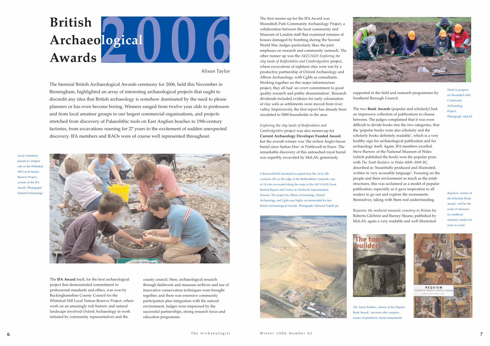
The biennial British Archaeological Awards ceremony for 2006, held this November in
Birmingham, highlighted an array of interesting archaeological projects that ought to
discredit any idea that British archaeology is somehow dominated by the need to please
planners or has even become boring. Winners ranged from twelve year olds to professors
and from local amateur groups to our largest commercial organisations, and projects
stretched from discovery of Palaeolithic tools on East Anglian beaches to 19th-century
factories, from excavations running for 27 years to the excitement of sudden unexpected
discovery. IFA members and RAOs were of course well represented throughout.
The IFA Award itself, for the best archaeologicalproject that demonstrated commitment toprofessional standards and ethics, was won byBuckinghamshire County Council for the Whiteleaf Hill Local Nature Reserve Project, wherework on an amazingly rich historic and naturallandscape involved Oxford Archaeology in workinitiated by community representatives and the
county council. Here, archaeological researchthrough fieldwork and museum archives and use ofinnovative conservation techniques were broughttogether, and there was extensive communityparticipation plus integration with the naturalenvironment. Judges were impressed by thesuccessful partnerships, strong research focus andeducation programme.
The first runner-up for the IFA Award wasShoreditch Park Community Archaeology Project, acollaboration between the local community andMuseum of London staff that examined remains ofhouses damaged by bombing during the SecondWorld War. Judges particularly likes the jointemphases on research and community outreach. Theother runner up was the A421/A428 Exploring theclay lands of Bedfordshire and Cambridgeshire project,where excavations of eighteen sites were run by aproductive partnership of Oxford Archaeology andAlbion Archaeology, with CgMs as consultants.Working together on this major infrastructureproject, they all had ‘an overt commitment to goodquality research and public dissemination’. Researchdividends included evidence for early colonisationof clay soils as settlements were moved from rivervalley. Impressively, the first report has already beencirculated to 5000 households in the area.
Exploring the clay lands of Bedfordshire andCambridgeshire project was also runner-up forCurrent Archaeology Developer Funded Award,but the overall winner was ‘the richest Anglo-Saxonburial since Sutton Hoo’ at Prittlewell in Essex. Theremarkable discovery of this untouched royal burialwas superbly excavated by MoLAS, generously
supported in the field and outreach programmes bySouthend Borough Council.
The two Book Awards (popular and scholarly) hadan impressive collection of publications to choosebetween. The judges complained that it was evendifficult to divide books into the two categories, thatthe ‘popular books were also scholarly and thescholarly books definitely readable’, which is a veryhealthy sign for archaeological publication and forarchaeology itself. Again, IFA members excelled.Steve Burrow of the National Museum of Wales(which published the book) won the popular prizewith The Tomb Builders in Wales 4000–3000 BC,described as ‘beautifully produced and illustrated,written in very accessible language’. Focusing on thepeople and their environment as much as the tombstructures, this was acclaimed as a model of popularpublication, especially as it gave inspiration to allreaders to go out and explore the monumentsthemselves, taking with them real understanding.
Requiem: the medieval monastic cemetery in Britain byRoberta Gilchrist and Barney Sloane, published byMoLAS, again a very readable and well illustrated
British ArchaeologicalAwards
Alison Taylor
W i n t e r 2 0 0 6 N u m b e r 6 2
Local volunteers
played an integral
role in the Whiteleaf
Hill Local Nature
Reserve Project,
winner of the IFA
Award. Photograph:
Oxford Archaeology
Work in progress
on Shoreditch Park
Community
Archaeology
Project.
Photograph: MoLAS
A Roman-British farnstead occupied from the 1st to 4th
centuries AD on the edge of the Bedfordshire claylands, one
of 18 sites excavated along the route of the A421/A428 Great
Barford Bypass and Caxton to Hardwick Improvements
Scheme. The project by Albion Archaeology, Oxford
Archaeology and CgMs was highly recommended for two
British Archaeological Awards. Photograph: Edmund Nuttall plc
Requiem, winner of
the Scholarly Book
Award, ‘will be the
work of reference
for medieval
mortuary studies for
years to come’
The Tomb Builders, winner of the Popular
Book Award, ‘uncovers rthe complex
nature of prehistoric burial monuments’

T h e A r c h a e o l o g i s t
book (and beautifully designed by TA’s designerSue Cawood), won the Scholarly Book Award. Thebook was described as ‘a groundbreaking piece ofsynthesis and analysis exemplifying the impact ofarchaeology alongside little-known documentarysources. This is an exemplary approach to burialstudies that will be the work of reference formedieval mortuary studies for years to come’.
Winners of the Association for IndustrialArchaeology prize were, most appropriately, theSPACE Organisation for regeneration of the CustardFactory itself, where the awards ceremony washeld. Bird’s Custard Factory really was the placethat the stuff we ate in our childhood was inventedand manufactured by Alfred Bird and his son,because his wife was allergic to eggs. The derelictindustrial buildings have now been reborn as anarts and media quarter and centre for creative
industries and were appreciated as an inspiringvenue.
The Young Archaeologist of the Year Award,organised by CBA’s Young Archaeologists’ Club,was a formal finale to a fun weekend that had takenClub members behind the scenes of variousBirmingham heritage attractions. Their two winnersfor this year’s theme of ‘Buildings’ were RachelTaylor and Yvette Taylor (no relations but asignificant surname), for studies of a Cambridgeprimary school and a Somerset windmill.
Not surprisingly, given the standard and quantity ofwork underwater today, there were six high qualitypublications short-listed for the Keith MuckelroyMemorial Award for maritime archaeology. Theoverall prize for ‘an amazing achievement’ went toJulie Gardiner and Michael Allen for Before the Mast:Life and death aboard the Mary Rose, published by theMary Rose Trust, with considerable input fromWessex Archaeology. Apparently, a daunting 54experts were co-ordinated to produce the catalogue,explanation and analysis – and this is only Volume4. The judges commented on how much the bookwas used by land archaeologists as well as themaritime kind, and how it will be a standardreference work for us all for a long time to come.
Other prize winners on the day included theChannel 4 Television Awards. The Broadcast Awardwent to The First Emperor, produced by LionTelevision for Channel 4, the Non-Broadcast Categoryto Sean Caveille for a series of interviews abouttelevision archaeology, and the ICT Award to StanBeckensall and Aron Mazel for Northumberland RockArt: Access to the Beckensall Archive. This remarkablearchive includes over 6000 rock art images pluspanoramic virtual reality views, all of which can besearched in various ways, and is a celebration of thework of the prolific Stan Beckensall. The Upper NeneArchaeological Society won not only the Mick AstonAward for the presentation of archaeology but alsothe Graham Webster Laurels, for work over 27 yearsat Piddington Roman villa. In addition to significantnew information, with a Claudian fort nowsuspected beneath the villa structure, the Friendship-Taylors and the Upper Nene Archaeological Societyhave trained their own volunteers, are publishingresults as fascicules and have also restored aredundant chapel for storage and display as therewas nowhere else in Northamptonshire to depositfinds. Nearly all if this work was through voluntaryeffort.
Discoveries by Mike Chambers, Bob Mulch andPaul Durbridge of flint tools on East Anglian
beaches demonstrated advanced hand-axetechnology now thought to be evidence for theearliest known occupation not only in Britain but inthe whole of northern Europe. These three sharp-sighted amateur archaeologists were the worthywinners of Tarmac’s Finders Award.
The Silver Trowel Award for the greatest initiative
in archaeology rewarded a different sort ofindividual achievement, that of John Barnett, whohas published a whole series of books and articleson the archaeology, especially the industrialarchaeology, of the Peak District. His prolific workis even more valuable for being published at manydifferent levels, significantly raising the profile ofarchaeology in the Peak District.
8 9W i n t e r 2 0 0 6 N u m b e r 6 2
The current Archaeological Award for Prittlewell went
to Southend on Sea Borough Council (their
representative is being cuddled by Mick Aston) and
MoLAS (Ian Blair, far right). Photograph: David Weight
Still digging at
Piddington Roman
villa, with yet
another building
discovered just
outside the villa.
Photograph: Roy
Friendship-Taylor
Prittlewell, ‘the remarkable
discovery of this untouched royal
burial’. Photographs: MoLAS
Rachel Taylor (second from right) and Yvette
Taylor (second from left) with their families at
the National Trust’s restored back-to-back houses
in Birmingham. Photograph: Young
Archaeologists Club (your editor is pale at
thinking that this really is archaoeology)
Sixteenth-century
dinner ware
illustrated in Before
the Mast: Life and
death aboard the
Mary Rose, winner
of the Keith
Muckelroy
Memorial Award
The Custard Factory – once
home of Bird’s Custard, now a
catalyst for creative people in
the West Midlands and host
for the British Archaological
Awards 2006

10 T h e A r c h a e o l o g i s t
In TA 55 I talked about one of the CBA’scases; the Cambridge Nuclear Bunker(thoughtfully described as the ugliestlisted building in Britain). Initiallyproposed for partial demolition which(would have seen one wall left standing)we have since advised on a newapplication which retains the building for storage use with minimal externalchange, and a recording condition forarchival purposes. That’s encouraging andwe do have other examples where webelieve we have made a difference.
DANGERS IN REGENERATIONThe urban regeneration of cities and towns, thoughwelcome in many ways, has led to a number ofcases where advice and gentle pressure can make anessential difference. Obvious cases are industrialsites – maltings, cotton mills, pottery works,ironworks and paper mills etc that are no longer inproduction. Their value now lies in thedevelopment potential of the site, with keybuildings often proposed for residential use (loft-style living in Manchester for example), and minorbuildings (which often played a part in theprocesses carried out on site) usually marked fordemolition, with a substantial element of new build,usually of many storeys.
ATTRITION AND SUBDIVISIONThere are also less obvious forms of attrition. Forexample, subdivision of a Victorian or Edwardianvilla for residential accommodation might involveinsertion of a lift shaft through a prestigiousentrance hall, or partitions breaking throughdecorative plasterwork and obscuring the originalplan form of the building (as illustrated in Bristol).Or it may be the loss of an 18th-century merchantshouse (eg 41 Pilcher Gate, Nottingham), which hasbeen added to in the 19th century as the buildingdropped in status to be used for warehousing andthen manufacturing: we need to make a case for thevalue that we believe these changes add to thebuilding and its site within the Lace MarketConservation Area, rather than accept that theydetract from the building. The same applied to theChurch Inn, Bury, which was proposed fordemolition for road widening and a Morrisonssupermarket.
WORKERS’ HOUSINGMy final example relates to the misguided idea thatregeneration requires demolition of workers’housing. How good it is to see in the government’sresponse to the Culture, Media and SportsCommittee Report on Protecting and Preserving our
11
D E F E N D I N G H I S TO R I C B U I L D I N G Si n t h eregenerat ion process
Lynne Walker
ADACTUS
alterations to
workers’ housing,
Every Street,
Nelson, Whitefield,
Lancashire.
Photograph: Sylvia
Wilson
Heritage October 2006 that many more Victorianhouses in the Pathfinder areas are to be refurbishedrather than demolished. We must however bear inmind that refurbishment comes in many forms.ADACTUS schemes in Whitefield, Lancashire andMoss Side, Manchester see the exteriors of terracesretained but the interiors gutted so that the plan iscompletely re-ordered. Service areas become livingrooms and former parlours become kitchens facingonto the main street, the back of the house is openfrom ground floor to roof slope, one bedroom is lostand in some cases the traditional Lancashire single-storey kitchen to the rear is demolished for frenchdoors overlooking the back alleys. Other notablesites where we became involved were the RoyalWorcester Porcelain site in Worcester, the Ironworkssite, St Edmondsbury in Bury St Edmunds and theNailsworth Maltings, Stroud.
This is just a snapshot of some of the 4000 cases wereceive annually. On top of these, this year weorganised a regional historic farm buildingsconference on behalf of the Historic Farm BuildingsForum at Bolton Abbey estate Yorkshire. There welooked at questions of conversion of traditionalfarm buildings, at new design in the landscape andat appropriate new uses for farm buildings. We alsoopened our headquarters, St Mary’s House, 66Bootham, York, for Heritage Open Days. We heldtwo introductory days on e-planning for ourvolunteers and took part in a pilot scheme withother national amenity societies and six selectedlocal authorities to monitor the effect of the changesin the planning system. And 2007 looks like beinganother interesting year.
Lynne WalkerHistoric Buildings OfficerCouncil for British Archaeology
W i n t e r 2 0 0 6 N u m b e r 6 2
ADACTUS
refurbishment of
terrace housing
Moss Side
Manchester.
Photograph: Sylvia
Wilson
Historic Farm Buildings Conference Yorkshire.
Tithe Barn Bolton Abbey Estate
41 Pilcher Gate, Nottingham – proposed for
demolition. Photograph: the Georgian Group
C
T h e A r c h a e o l o g i s t 13
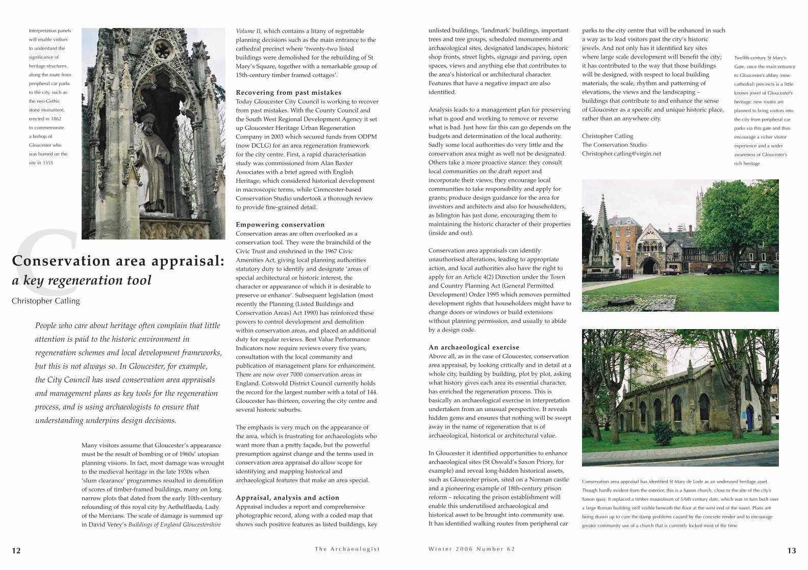
Many visitors assume that Gloucester’s appearancemust be the result of bombing or of 1960s’ utopianplanning visions. In fact, most damage was wroughtto the medieval heritage in the late 1930s when‘slum clearance’ programmes resulted in demolitionof scores of timber-framed buildings, many on longnarrow plots that dated from the early 10th-centuryrefounding of this royal city by Aethelflaeda, Ladyof the Mercians. The scale of damage is summed upin David Verey’s Buildings of England Gloucestershire
Volume II, which contains a litany of regrettableplanning decisions such as the main entrance to thecathedral precinct where ‘twenty-two listedbuildings were demolished for the rebuilding of StMary’s Square, together with a remarkable group of15th-century timber framed cottages’.
Recovering from past mistakesToday Gloucester City Council is working to recoverfrom past mistakes. With the County Council andthe South West Regional Development Agency it setup Gloucester Heritage Urban RegenerationCompany in 2003 which secured funds from ODPM(now DCLG) for an area regeneration frameworkfor the city centre. First, a rapid characterisationstudy was commissioned from Alan BaxterAssociates with a brief agreed with EnglishHeritage, which considered historical developmentin macroscopic terms, while Cirencester-basedConservation Studio undertook a thorough reviewto provide fine-grained detail.
Empowering conservationConservation areas are often overlooked as aconservation tool. They were the brainchild of theCivic Trust and enshrined in the 1967 CivicAmenities Act, giving local planning authoritiesstatutory duty to identify and designate ‘areas ofspecial architectural or historic interest, thecharacter or appearance of which it is desirable topreserve or enhance’. Subsequent legislation (mostrecently the Planning (Listed Buildings andConservation Areas) Act 1990) has reinforced thesepowers to control development and demolitionwithin conservation areas, and placed an additionalduty for regular reviews. Best Value PerformanceIndicators now require reviews every five years,consultation with the local community andpublication of management plans for enhancement.There are now over 7000 conservation areas inEngland. Cotswold District Council currently holdsthe record for the largest number with a total of 144.Gloucester has thirteen, covering the city centre andseveral historic suburbs.
The emphasis is very much on the appearance ofthe area, which is frustrating for archaeologists whowant more than a pretty façade, but the powerfulpresumption against change and the terms used inconservation area appraisal do allow scope foridentifying and mapping historical andarchaeological features that make an area special.
Appraisal, analysis and actionAppraisal includes a report and comprehensivephotographic record, along with a coded map thatshows such positive features as listed buildings, key
unlisted buildings, ‘landmark’ buildings, importanttrees and tree groups, scheduled monuments andarchaeological sites, designated landscapes, historicshop fronts, street lights, signage and paving, openspaces, views and anything else that contributes tothe area’s historical or architectural character.Features that have a negative impact are alsoidentified.
Analysis leads to a management plan for preservingwhat is good and working to remove or reversewhat is bad. Just how far this can go depends on thebudgets and determination of the local authority.Sadly some local authorities do very little and theconservation area might as well not be designated.Others take a more proactive stance: they consultlocal communities on the draft report andincorporate their views; they encourage localcommunities to take responsibility and apply forgrants; produce design guidance for the area forinvestors and architects and also for householders,as Islington has just done, encouraging them tomaintaining the historic character of their properties(inside and out).
Conservation area appraisals can identifyunauthorised alterations, leading to appropriateaction, and local authorities also have the right toapply for an Article 4(2) Direction under the Townand Country Planning Act (General PermittedDevelopment) Order 1995 which removes permitteddevelopment rights that householders might have tochange doors or windows or build extensionswithout planning permission, and usually to abideby a design code.
An archaeological exerciseAbove all, as in the case of Gloucester, conservationarea appraisal, by looking critically and in detail at awhole city, building by building, plot by plot, askingwhat history gives each area its essential character,has enriched the regeneration process. This isbasically an archaeological exercise in interpretationundertaken from an unusual perspective. It revealshidden gems and ensures that nothing will be sweptaway in the name of regeneration that is ofarchaeological, historical or architectural value.
In Gloucester it identified opportunities to enhancearchaeological sites (St Oswald’s Saxon Priory, forexample) and reveal long-hidden historical assets,such as Gloucester prison, sited on a Norman castleand a pioneering example of 18th-century prisonreform – relocating the prison establishment willenable this underutilised archaeological andhistorical asset to be brought into community use. It has identified walking routes from peripheral car
12
Conservation area appraisal: a key regeneration toolChristopher Catling
parks to the city centre that will be enhanced in sucha way as to lead visitors past the city’s historicjewels. And not only has it identified key siteswhere large scale development will benefit the city;it has contributed to the way that those buildingswill be designed, with respect to local buildingmaterials, the scale, rhythm and patterning ofelevations, the views and the landscaping –buildings that contribute to and enhance the senseof Gloucester as a specific and unique historic place,rather than an anywhere city.
Christopher CatlingThe Conservation [email protected]
Twelfth-century St Mary’s
Gate, once the main entrance
to Gloucester’s abbey (now
cathedral) precincts is a little
known jewel of Gloucester’s
heritage: new routes are
planned to bring visitors into
the city from peripheral car
parks via this gate and thus
encourage a richer visitor
experience and a wider
awareness of Gloucester’s
rich heritage
Interpretation panels
will enable visitors
to understand the
significance of
heritage structures
along the route from
peripheral car parks
to the city, such as
the neo-Gothic
stone monument,
erected in 1862
to commemorate
a bishop of
Gloucester who
was burned on the
site in 1555
Conservation area appraisal has identified St Mary de Lode as an underused heritage asset.
Though hardly evident from the exterior, this is a Saxon church, close to the site of the city’s
Saxon quay. It replaced a timber mausoleum of 5/6th century date, which was in turn built over
a large Roman building (still visible beneath the floor at the west end of the nave). Plans are
being drawn up to cure the damp problems caused by the concrete render and to encourage
greater community use of a church that is currently locked most of the time
W i n t e r 2 0 0 6 N u m b e r 6 2
People who care about heritage often complain that little
attention is paid to the historic environment in
regeneration schemes and local development frameworks,
but this is not always so. In Gloucester, for example,
the City Council has used conservation area appraisals
and management plans as key tools for the regeneration
process, and is using archaeologists to ensure that
understanding underpins design decisions.

14 15T h e A r c h a e o l o g i s t
Group to develop heritage construction skills forindustry which will be taught at the new campus.
Consideration of the heritage asset has influencedthis regeneration scheme and been an importantfactor in the development of design solutions. Thedevelopment as a whole has benefited from thedesign and setting of the nearby Llanthony SecundaPriory and the challenge of innovative design.
MARRYING HISTORICAL CONTEXT ANDCONTEMPORARY DESIGNAll these projects demonstrate that there can besuccessful marriages between the public and privatesectors, and historical context and contemporarydesign. The direct benefits to heritage are acombination of preservation in situ and sustainable,sympathetic restoration and reuse withincontemporary townscapes. These developments canaid regeneration of larger areas by drawing peoplein, providing upgraded facilities and public openspace and creating new sustainable communities.
Heritage consultants must be able to understand thewider aspects and implications of commercialdevelopment as well as the economic forces thatdrive regeneration. Our role also encompassesdesign of imaginative and innovative solutionswithin complex multi-faceted projects. Public sectorsupport is important within regeneration, andheritage is an important element allowingindividual projects to stand apart. It is important,however, to realise as professionals thatregeneration will not occur without private sectordevelopment skills.
Neil MacnabSenior Archaeological ConsultantScott WilsonThe Design Innovation Centre46 The Calls, Leeds LS2 7EY
Metropolitan District Council. It involvesregeneration of the historic Wakefield waterfrontarea, including Calder Navigation Warehouse,adjacent to the Aire and Calder Navigation. Thescheme comprises sympathetic conversion of threelisted mill complexes as part of extensive mixed-usedevelopment which will revitalise and give asustainable future for this derelict district on theedge of Wakefield. CTP St James Ltd has provided arobust business case, which has attracted publicsector grants to enable the listed buildings to beretained and converted. The scheme has enabledwaterfront areas and features to be opened up to thepublic and will bring this part of Wakefield backinto the town centre. It also will complement otherregeneration initiatives within the town. Extensivepublic consultation has engendered great supportwith increased understanding of the area’sindustrial archaeology.
LLANTHONY WHARF: MEDIEVAL PRIORY ANDMODERN COLLEGE Scott Wilson were appointed by GLOSCAT (acollege/campus for 16+ education and technicalskills) to design an archaeological strategy forpreservation of nationally important archaeologicalremains associated with, but outside, the scheduledarea of Llanthony Secunda Priory (part of the largerGloucester Quays Regeneration Scheme). Thedevelopment will house the new college. Researchand evaluation informed sensitive design offoundations, including particular pile settings, piletypes, concrete beams and the spanning ofarchaeological remains. We worked closely withdesign engineers, the Gloucester City Councilarchaeology officer and English Heritage.
Made ground was stripped to expose archaeologicalhorizons which were cleaned, planned and assessed.Collaborative design then resulted in the option of apile grid and spanning regime to allow 95% of thearchaeological remains to be preserved. Theserevealed evidence for medieval cloisters, providinginformation on their layout, form, function, date andcharacter. Evidence for medieval burial practicewithin the priory cloister area was also revealed.
Beneficial aspects of this regeneration projectinclude preservation of the majority of thesenationally important archaeological deposits, thesensitive design and setting of the new building inrelation to the Priory, and creation of acontemporary but complementary environmentwithin the heart of the Gloucester Quays. Thearchaeological investigations raised local interest inheritage, and GLOSCAT are now working withEnglish Heritage and the National Heritage Training
GLOSCAT during
excavation, looking
towards Llanthony
Secunda Priory.
© Scott Wilson
Downings Malthouse, Grade II listed Canal-side
warehouse, Gloucester Quays © Peel Holdings
The experience of Scott Wilson Heritage Group, which has been working
in the UK regeneration sector since 2002, shows that in most cases
regeneration, though led by the public sector, cannot be delivered unless
the private sector is also involved. Heritage is important, but one of many
elements within any regeneration scheme. This article illustrates the
approach we have taken in some key projects.
GLOUCESTER QUAYS: HISTORIC BUILDINGSSECURED FOR THE FUTUREThis regeneration scheme covering 25 acres is bisectedby the Gloucester and Sharpness Canal and incorporates14 listed canal-side structures, a conservation area andLlanthony Secunda Priory. Development willcomprise private residential and affordable housing,new highway infrastructure, a canal bridge and afactory outlet as well as retail, hotel and leisurefacilities and a new further education college.
Benefits that flow from this mixed-use regenerationinclude reuse and conversion of listed buildings,particularly derelict canal-side warehouses, andrevitalisation of a run-down area on the edge ofGloucester city centre. Llanthony Secunda Priory, ascheduled monument at the heart of thedevelopment area, will be enhanced and broughtback into the public domain, with long-term plansfor its care, use and appreciation.
The development scheme enjoys public support andhas done much for the heritage within Gloucester. Itshould, however, be borne in mind that heritage wasnot the main driver: without the factory outlet,regeneration would not be commercially viable andlisted buildings would not be refurbishedsympathetically. Combining private sector skills andheritage has created a development scheme that iscreative, vibrant and dynamic, mixing contemporarydesign and historic structures to produce moderndevelopment with a sustainable future. GloucesterQuays is providing a real stimulus for otherregeneration schemes within Gloucester.
WAKEFIELD WATERFRONT: INDUSTRIALARCHAEOLOGY AND REGENERATIONThis major urban regeneration project in the northof England is being undertaken by CTP St James Ltdwith partners British Waterways and Wakefield
W i n t e r 2 0 0 6 N u m b e r 6 2
Urban regeneration and commercially viable,sustainable heritage solutions Neil Macnab
GLOSCAT pre-excavation
plan, revealing pile positions
and areas that require
excavation.
© Scott Wilson

16 17T h e A r c h a e o l o g i s t
Southampton was one of England’s leadingmedieval ports. During the 13th century and againin the 15th century its trade in commodities such aswine, wool and cloth made it one of the mostprosperous and cosmopolitan towns in the country.From the later 16th century much international tradewas lost to other ports (principally London) andSouthampton suffered a long decline, until itsfortunes revived with the growth of passenger tradeto America in the mid 19th century.
� Devastation During the Second World War the city suffereddevastating bombing, and post-war reconstructionpaid little regard to the historic character of the oldtown. Medieval property plots were widened orignored, building heights increased, and theconstruction of the Castle Way inner ring-road in the1950s sliced through the medieval gridded streetpattern.
In 2000 Southampton planning department adoptedthe ‘Southampton Old Town development strategy’.The aim of this was ‘to rediscover, conserve,enhance and redefine the Old Town’s historiccharacter’. Although few timber-framed buildingssurvived war and redevelopment, Southampton stillhas a rich legacy of historic vaulted cellars andstretches of town wall, over ninety listed buildingsand 45 ancient monuments.
� Blight and reinstatementNow, thanks to co-operation between Linden HomesSouthern Ltd and the planning department, newapartments within the French Quarter have includedreinstatement of elements of the medieval streetpattern. Castle Way ring-road has been removed,and the frontage of French Street has been pushedback to its medieval line. Brewhouse Lane, athoroughfare that may date from the origins of themedieval port in the late Saxon period, has beenreinstated, allowing a line of sight from the HighStreet to the medieval Merchant’s House in French
Street. The whole effect is a development insympathy with its surviving medievalsurroundings, a first step in enhancing an areablighted by rapid post-war redevelopment.
Oxford Archaeology was appointed by CgMsConsulting, acting for Linden Homes, to excavatethe area in advance of construction. The site coversapproximately 0.5 ha, with an impressive sequenceof medieval vaulted cellars. The entire footprint ofthe development and all areas subject to below-ground impact were excavated.
� Fossilisation for a thousand yearsPits and structures of late Saxon to 12th-centurydate apparently formed part of a rapidly developingbut loosely structured settlement. In the 13thcentury the whole area was laid out anew, this timeon a formal grid pattern. Excavations revealedthoroughfares and tenement boundaries of the 13thcentury, defined by medieval and later cellar wallsthat had largely survived until 1950. Thisfossilisation of property boundaries allows us tocorrelate the structural history of the site withartefacts and environmental evidence from nearly athousand 13th- to 19th-century backyard pits,cisterns and latrines, and with the wealth ofdocumentary resources for the area. A wide range offinds includes exotic and rare pottery imports, afiring mechanism for a 14th-century crossbow, andthe stock of a 1940s’ chemist shop that was bombedinto the medieval cellar below. The wholeassemblage will provide a massive demographicdataset.
� Polymond Hall/Hampton Court: a Venetianambassador and a nonconformist hymn writerOne interesting property fronting onto French Streethad been a timber building in the 10th to 12thcenturies but by the 13th century is identified indocumentary sources as the location of the ‘greatstone houses of Richard of Leicester’, a leadingtownsman of his day. The property was acquired bySt Denys’s Priory, probably in 1371 as the gift ofRoger Haywode, and in the late 14th century it wasthe residence of another leading citizen, John
Polymond, after whom it was subsequently named.During the 15th century Polymond Hall was hometo an Italian merchant and to the Venetianambassador, and exotic pottery has been recoveredfrom a latrine in the courtyard.
A central courtyard was laid in the 16th century. By the 1620s the property was described as a largehouse with outbuildings, stables, shops, cellars,gardens and orchards. The Nonconformist Wattsfamily lived here from 1675 to 1737, and the housewas the boyhood home of the celebrated hymnwriter Isaac Watts. His father, Isaac Watts Snr, ran aboarding school and a small cloth factory at the site.
In 1737 the property was sold to the Woodfordfamily, who carried out extensive remodelling andrenamed it Hampton Court. The Woodfords may beresponsible for much of thelayout visible on the RoyalEngineers’ Map of 1846,which shows a house builtaround three sides of acourtyard garden with afurther garden to the rear.During the 19th century theproperty became a postoffice and then HamptonCourt Brewery.
Richard BrownOxford [email protected]
RevivingSouthampton’s French QuarterRichard Brown
58 French Street, a medieval
merchant’s house, adjacent
to the site. © Oxford
Archaeology
The site under excavation
(High Street to the right,
Castle Way to the left of the
photograph). © Oxford
Archaeology
An unexpected medieval
well-house (with 16th-
century rebuild) in the back
garden of tenement 237
Polymond Hall/Hampton
Court. © Oxford
New development in the historic
core of Southampton, informed by
historical research and excavation,
is reinstating elements of the
medieval street pattern that had
been lost during unsympathetic
post-war reconstruction.
Reconstruction of the medieval cellar. © Oxford Archaeology
W i n t e r 2 0 0 6 N u m b e r 6 2
18 T h e A r c h a e o l o g i s t
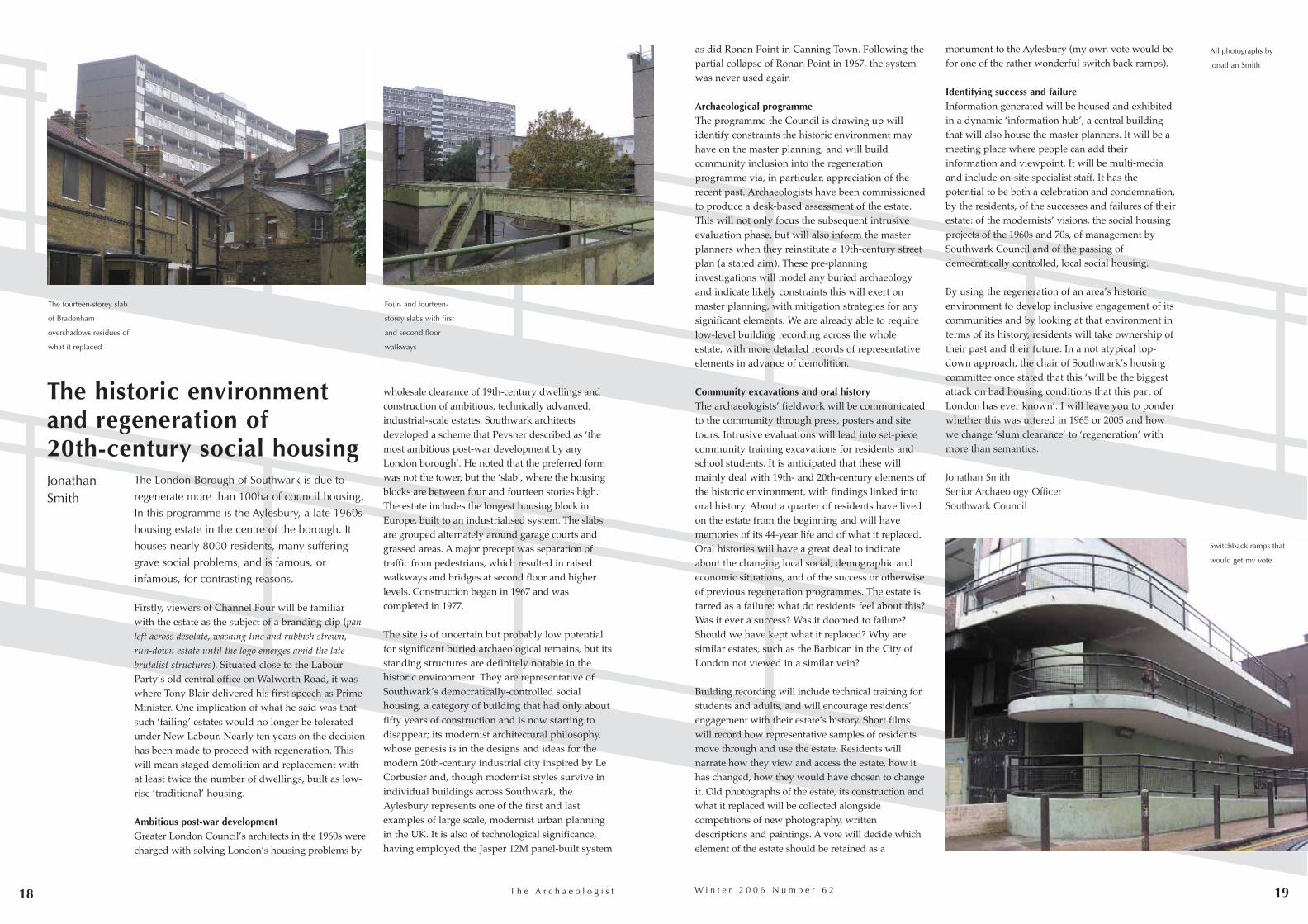
The London Borough of Southwark is due to
regenerate more than 100ha of council housing.
In this programme is the Aylesbury, a late 1960s
housing estate in the centre of the borough. It
houses nearly 8000 residents, many suffering
grave social problems, and is famous, or
infamous, for contrasting reasons.
Firstly, viewers of Channel Four will be familiarwith the estate as the subject of a branding clip (panleft across desolate, washing line and rubbish strewn,run-down estate until the logo emerges amid the latebrutalist structures). Situated close to the LabourParty’s old central office on Walworth Road, it waswhere Tony Blair delivered his first speech as PrimeMinister. One implication of what he said was thatsuch ‘failing’ estates would no longer be toleratedunder New Labour. Nearly ten years on the decisionhas been made to proceed with regeneration. Thiswill mean staged demolition and replacement withat least twice the number of dwellings, built as low-rise ‘traditional’ housing.
Ambitious post-war developmentGreater London Council’s architects in the 1960s werecharged with solving London’s housing problems by
wholesale clearance of 19th-century dwellings andconstruction of ambitious, technically advanced,industrial-scale estates. Southwark architectsdeveloped a scheme that Pevsner described as ‘themost ambitious post-war development by anyLondon borough’. He noted that the preferred formwas not the tower, but the ‘slab’, where the housingblocks are between four and fourteen stories high.The estate includes the longest housing block inEurope, built to an industrialised system. The slabsare grouped alternately around garage courts andgrassed areas. A major precept was separation oftraffic from pedestrians, which resulted in raisedwalkways and bridges at second floor and higherlevels. Construction began in 1967 and wascompleted in 1977.
The site is of uncertain but probably low potentialfor significant buried archaeological remains, but itsstanding structures are definitely notable in thehistoric environment. They are representative ofSouthwark’s democratically-controlled socialhousing, a category of building that had only aboutfifty years of construction and is now starting todisappear; its modernist architectural philosophy,whose genesis is in the designs and ideas for themodern 20th-century industrial city inspired by LeCorbusier and, though modernist styles survive inindividual buildings across Southwark, theAylesbury represents one of the first and lastexamples of large scale, modernist urban planningin the UK. It is also of technological significance,having employed the Jasper 12M panel-built system
19
as did Ronan Point in Canning Town. Following thepartial collapse of Ronan Point in 1967, the systemwas never used again
Archaeological programmeThe programme the Council is drawing up willidentify constraints the historic environment mayhave on the master planning, and will buildcommunity inclusion into the regenerationprogramme via, in particular, appreciation of therecent past. Archaeologists have been commissionedto produce a desk-based assessment of the estate.This will not only focus the subsequent intrusiveevaluation phase, but will also inform the masterplanners when they reinstitute a 19th-century streetplan (a stated aim). These pre-planninginvestigations will model any buried archaeologyand indicate likely constraints this will exert onmaster planning, with mitigation strategies for anysignificant elements. We are already able to requirelow-level building recording across the wholeestate, with more detailed records of representativeelements in advance of demolition.
Community excavations and oral history The archaeologists’ fieldwork will be communicatedto the community through press, posters and sitetours. Intrusive evaluations will lead into set-piececommunity training excavations for residents andschool students. It is anticipated that these willmainly deal with 19th- and 20th-century elements ofthe historic environment, with findings linked intooral history. About a quarter of residents have livedon the estate from the beginning and will havememories of its 44-year life and of what it replaced.Oral histories will have a great deal to indicateabout the changing local social, demographic andeconomic situations, and of the success or otherwiseof previous regeneration programmes. The estate istarred as a failure: what do residents feel about this?Was it ever a success? Was it doomed to failure?Should we have kept what it replaced? Why aresimilar estates, such as the Barbican in the City ofLondon not viewed in a similar vein?
Building recording will include technical training forstudents and adults, and will encourage residents’engagement with their estate’s history. Short filmswill record how representative samples of residentsmove through and use the estate. Residents willnarrate how they view and access the estate, how ithas changed, how they would have chosen to changeit. Old photographs of the estate, its construction andwhat it replaced will be collected alongsidecompetitions of new photography, writtendescriptions and paintings. A vote will decide whichelement of the estate should be retained as a
monument to the Aylesbury (my own vote would befor one of the rather wonderful switch back ramps).
Identifying success and failureInformation generated will be housed and exhibitedin a dynamic ‘information hub’, a central buildingthat will also house the master planners. It will be ameeting place where people can add theirinformation and viewpoint. It will be multi-mediaand include on-site specialist staff. It has thepotential to be both a celebration and condemnation,by the residents, of the successes and failures of theirestate: of the modernists’ visions, the social housingprojects of the 1960s and 70s, of management bySouthwark Council and of the passing ofdemocratically controlled, local social housing.
By using the regeneration of an area’s historicenvironment to develop inclusive engagement of itscommunities and by looking at that environment interms of its history, residents will take ownership oftheir past and their future. In a not atypical top-down approach, the chair of Southwark’s housingcommittee once stated that this ‘will be the biggestattack on bad housing conditions that this part ofLondon has ever known’. I will leave you to ponderwhether this was uttered in 1965 or 2005 and howwe change ‘slum clearance’ to ‘regeneration’ withmore than semantics.
Jonathan SmithSenior Archaeology OfficerSouthwark Council
The historic environment and regeneration of 20th-century social housingJonathan Smith
Four- and fourteen-
storey slabs with first
and second floor
walkways
The fourteen-storey slab
of Bradenham
overshadows residues of
what it replaced
All photographs by
Jonathan Smith
W i n t e r 2 0 0 6 N u m b e r 6 2
Switchback ramps that
would get my vote

20 21T h e A r c h a e o l o g i s t
centuries. In 1985 it was designated a site ofCultural Heritage and added to the list ofAndalucian Historical Heritage in 1988. Post-medieval buildings north of the causeway suppliedtroop needs and facilitated ship building and repair.New buildings increased capacity during theSuccession War of 1700-14. The complex, guardedby flanking batteries, was besieged by Napoleon,and Cadiz became the focus of French-free Spain.The Spanish congress in Cadiz drafted the newconstitution here that became law in 1812. The siteis therefore nationally important and provides keyanniversary dates by which to achieve the site’srehabilitation.
Maltese heritage‘Three Cities’ is the main ancient settlement onMalta, built on tongues of land that project into theGrand Harbour. It was this feature that gave peopletheir livelihoods in trade and in building andrepairing ships. The Knights arrived in 1530 andfortified the Three Cities until a new capital,Valletta, was built on the far side of the harbour. Inthe Second World War Malta sustained almostcontinuous bombing, and afterwards peoplegenerally did not move back to bombed out ancientsettlements, so the area became extremely poor. TheMaltese have tended to focus on the period of theKnights of Malta to build a successful tourist tradebut this has been to the detriment of their morerecent history. Enter the Malta Heritage Trust, whichhas taken on important neglected sites anddeveloped tourist and, equally important,
One outcome was that methods in dealing withheritage issues deserved a wider audience, and aEuropean project under INTERREG IIIc wouldfulfill this aspiration. Finance from LDA and thelead developer, Berkeley Homes (East Thames) Ltd,enabled 21st Century ERA Ltd to win support fromthe European Union funding authority. OxfordArchaeology was invited to take part, havingundertaken building recording and most of thearchaeological fieldwork on site.
Arsenal sites Taking former arsenal sites as the common vehiclein looking at major historic brownfield sites,partners are the University of Cadiz with the RealCarenero and Suazo Bridge, Malta Heritage Trust withtheir Malta at War Museum and Shelters, Three Cities,and the Estonian Arts Academy supported by theEstonian Heritage Board with Battery on the Balticcoast north of Tallinn.
Real CareneroReal Carenero, the old arsenal of the Suazo Bridgesites, in an area of saltmarsh guarding the causewaythat linked Cadiz with mainland Spain, has beenlargely neglected, and squatters and a scrap metalbusiness have taken up residence. Suazo Bridge isRoman in origin but was much repaired in later
S H A R P PRACTICE:
regenerating historic military sitesin EuropeMark Stevenson
ministerial interest. A current venture, the Malta atWar Museum, gives people a chance to learn aboutwhat happened at the individual and family level,with access to wartime shelters kitted out withauthentic donated material. Success of this ventureis dependent upon other enterprises within theThree Cities working together to provide acomplementary package to entice visitors as well asproviding a stronger lobbying voice.
Defences and the prison at TallinnBattery, on the Baltic coast to the west of the mainharbour of Tallinn, was built by Czar Nicholas I in1827 as part of the Baltic defence system to protectthe approach to St Petersburg. The arc-shaped three-storey building contained 162 cannons but wasnever used in anger. Behind the main building twoconverging wings housed the officers, offices andother functions before use of the site changed in 1858to that of a warehouse, flats and an Orthodox church.
Following the Russian Revolution, Estonia declaredindependence but was immediately overrun byGermany. Following the Estonian War ofIndependence in 1920 Battery became first adetention centre and then the central prison ofTallinn. In 1940 Russia captured Estonia, only forGermany to retake it in 1941. Battery was used aspart of the ‘final solution’, with a large number ofpeople being transferred to the prison before beingmurdered. When Russia regained control of Estoniafollowing the war it continued the prison use of thesite, and across the country in the first four years
English Heritage London Region has beeninvolved with regeneration of the former RoyalArsenal, Woolwich site for over ten years. Whenthe original masterplan was approved in 2000, thelandowners, London Development Agency, LDA,were well advanced in an extensive programmeof remediation and basic maintenance of some ofthe 22 Listed Buildings.
In 2001 English Heritage hosted a stakeholderseminar to identify what more needed to be done.
W i n t e r 2 0 0 6 N u m b e r 5 9
Fort St Angelo
dominates the
Grand Harbour of
Malta within an
extensive system of
defences. © English
Heritage
Detail of the central
feature of the Real
Carenero façade,
Cadiz. © English
Heritage
No.1 Dock, The
Grand Harbour,
Three Cities, the
focus of several
initiatives, public
and private, that
are now coming
together to develop
a common strategy
W i n t e r 2 0 0 6 N u m b e r 6 2T h e A r c h a e o l o g i s t 23
60,000 Estonians were either killed or deported.Following Independence in 1991, Estonia joined theEU in 2004 and the prison finally vacated the site in2005. Various schemes have been suggested but therecent declaration by the National Heritage Board isthat it should be a cultural site.
Woolwich Royal ArsenalThe history of The Warren, Woolwich goes back tohurried construction of the triangular Prince RupertFort at the edge of the marsh east of what is nowWoolwich Ferry in 1667, to protect Woolwichdockyard and London from possible Dutch attack.In the 18th century this fort disappeared under landreclamation as the site expanded to provide a widerange of arsenal functions. In 1805 George III re-
named it the Royal Arsenal, and it grew with eachmilitary action within the British empire. By theFirst World War it occupied 1285 acres andemployed 80,000 people, many of them women.
Between the wars there was some non-militarywork such as manufacture of milk churns andlocomotives, to ease unemployment. Thenpreparations for war were stepped up so that by1940 40,000 people were working here. The site waseventually closed in 1967, with 500 acres given tothe GLC to build Thamesmead. The western historiccore was the subject of clearance of many buildingsand the remediation of an earlier infilled canal,before being sold to English Partnerships for £1with the aspiration to see the site regenerated.
SHARP’s diverse mixEach site and partner represent a diverse mix thathas gives SHARP its richness and strength, enablingthe group to produce a clear guidance ‘blueprint’.With a framework for regeneration of historicbrownfield sites, each partner will be encouraged todevelop specific guidance that fits its own planning,political and cultural context.
The project was launched at Woolwich in December2004 to a capacity audience, followed by two roundsof partner meetings in each of the participatingcountries. Round one was primarily fact finding, thesecond to meet local stakeholders, promote SHARPand provide a vehicle to raise local awareness. Ineach country there has been interest expressed bynational newspapers and television as well asregional and national politicians. In the secondround partners spoke in more detail with localrepresentatives and discussed shared experiences inworkshops, looking in detail at the six identifiedthemes: master planning, public/privatepartnership, heritage, tourism, education andsustainable regeneration.
The two-year project is to culminate with aconference at Firepower! the Royal ArtilleryMuseum, Royal Arsenal, Woolwich, 6 February2007. Admission is free but due to limited space,application will need to be made for a seat.
For further information: [email protected]
Mark [email protected]
Major historic ports in south-east Wales (Chepstow, Newport,Cardiff and Swansea), followedby subsidary ports and majorlanding-places and havens, havebeen studied by Glamorgan-Gwent Archaeological Trust with support from Cadw in orderto inform and encourage futureconservation of a crucial heritageresource.
Regional sites and monumentsrecords, the National MonumentsRecord, documentary andcartographic evidence and other published sourcesformed a project database which was linked toOrdnance Survey data using GIS. Historic mapswere geocoded and overlaid with OS data, enablingmap regression. The course of rivers and position ofwaterfront features were plotted, the condition ofknown sites ascertained and further unreportedinterests identified on site visits, and the potentialfor survival of maritime archaeological remains wasassessed. Zoned maps were created to showingareas of high, medium and low potential.
Waterfronts are not static relicts of the past but havealtered, and continue to alter, with changingfashions and requirements. Indeed, the location ofthe modern docks in Cardiff, Newport and Swanseaare all some distance from the medieval harbours,having moved downstream to accommodatepassage of larger vessels. River courses alter overtime through natural erosion or silting. In Cardiffand Swansea, the rivers were canalised in the 19thcentury to create an artificial topography.
Urban waterfronts in WalesAndrew Marvell and Kate Howell
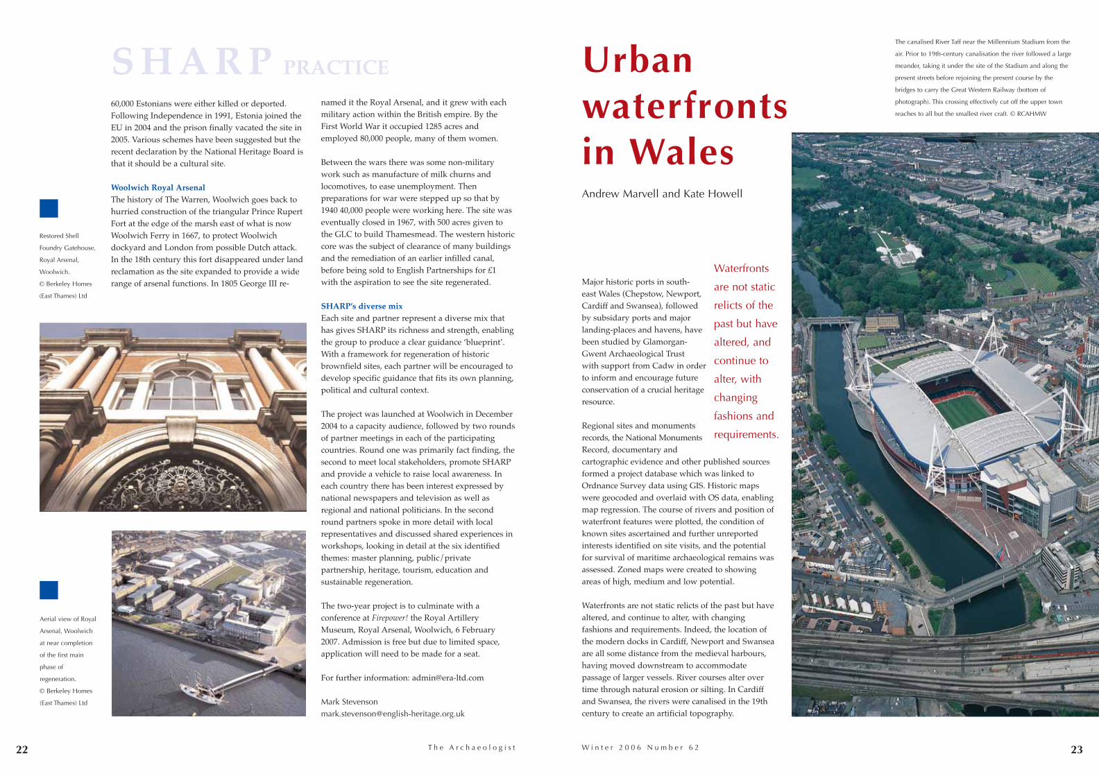
The canalised River Taff near the Millennium Stadium from the
air. Prior to 19th-century canalisation the river followed a large
meander, taking it under the site of the Stadium and along the
present streets before rejoining the present course by the
bridges to carry the Great Western Railway (bottom of
photograph). This crossing effectively cut off the upper town
reaches to all but the smallest river craft. © RCAHMW
Waterfronts
are not static
relicts of the
past but have
altered, and
continue to
alter, with
changing
fashions and
requirements.
Aerial view of Royal
Arsenal, Woolwich
at near completion
of the first main
phase of
regeneration.
© Berkeley Homes
(East Thames) Ltd
Restored Shell
Foundry Gatehouse,
Royal Arsenal,
Woolwich.
© Berkeley Homes
(East Thames) Ltd
22
S H A R P PRACTICE
24 25T h e A r c h a e o l o g i s t
modern environment. The differences andsimilarities of waterfront activities over time can beaddressed, and continuities and changes of useunderstood. In maintaining a connection with thepast, a deep-rooted sense of place can beengendered, which will enhance the experiences ofthose working in, living in and visiting waterfrontlocations.
A booklet on the project, Wales, waterfronts and theworld, Glamorgan-Gwent Archaeological Trust Ltd
The waterfront resource
The cultural heritage resource of these waterfrontlocations takes many forms and may be visible orburied. It includes shipwrecks, wharfs, slipwaysand other structures; transport infrastructure,including roads, railways and canals; buildingsincluding warehouses, churches and lighthouses,and palaeoenvironmental information. Evidencemay be documentary and from oral history sources,or from pictographic, cartographic andphotographic records.
Spectacular archaeological discoveries such as theNewport Ship excite us all, but apparentlymundane remains include a lightship The Juno stillmoored at Briton Ferry, which took part in theevacuation of Allied troops from Dunkirk. Whilstnot always as visually exciting as boats and ships,the information that can be gathered from survivingstructures, transport infrastructure and buildings isof great value when examining the nature andextent of past exploitation of these waterfront areas.These features give an insight into the range of
activities that took place, and demonstrate the scaleof sea-borne and river-borne commerce in the past.
Waterfronts at risk
Waterfront resources are at risk for a variety ofreasons. The locations are increasingly underpressure from urban regeneration projects, and thedesirability of waterside locations for residential,cultural and commercial developments can be seenin the number of schemes currently being plannedand implemented across south-east Wales.Engineering schemes to protect the modernwaterfront settlements, such as flood alleviationprojects, can disturb features, artefacts andpalaeoenvironmental deposits. Developmentpressure means these locations are increasingly builtupon, with loss to the cultural heritage resource,often in a piecemeal manner.
The fragile nature of many waterfront remainsmeans they can be easily damaged. Woodenstructures survive remarkably well whenwaterlogged, but once this anaerobic environment isdisturbed, rapid decay begins.
Why protect waterfronts?
The benefits of preserving the cultural heritage ofwaterfront locations include both social andeconomic advantages. The incorporation of historicfeatures within new developments gives a project aunique aspect, creating a distinctive andcharacteristic new environment that remains linkedwith the past. In commercial schemes thisdistinctiveness can be successfully marketed as aselling point. On a wider scale, the preservation ofthe historic environment is vital for the expandingheritage tourism industry.
The value of preserving historic features is equallyimportant in social terms. Highlighting the historicenvironment of an area encourages respect for the
(ISBN 1-870419-05-7) has been prepared and results have already been disseminated directly to key audiences.
Andrew Marvell and Kate HowellGlamorgan-Gwent Archaeological TrustHeathfield HouseHeathfieldSwanseaSA1 [email protected]
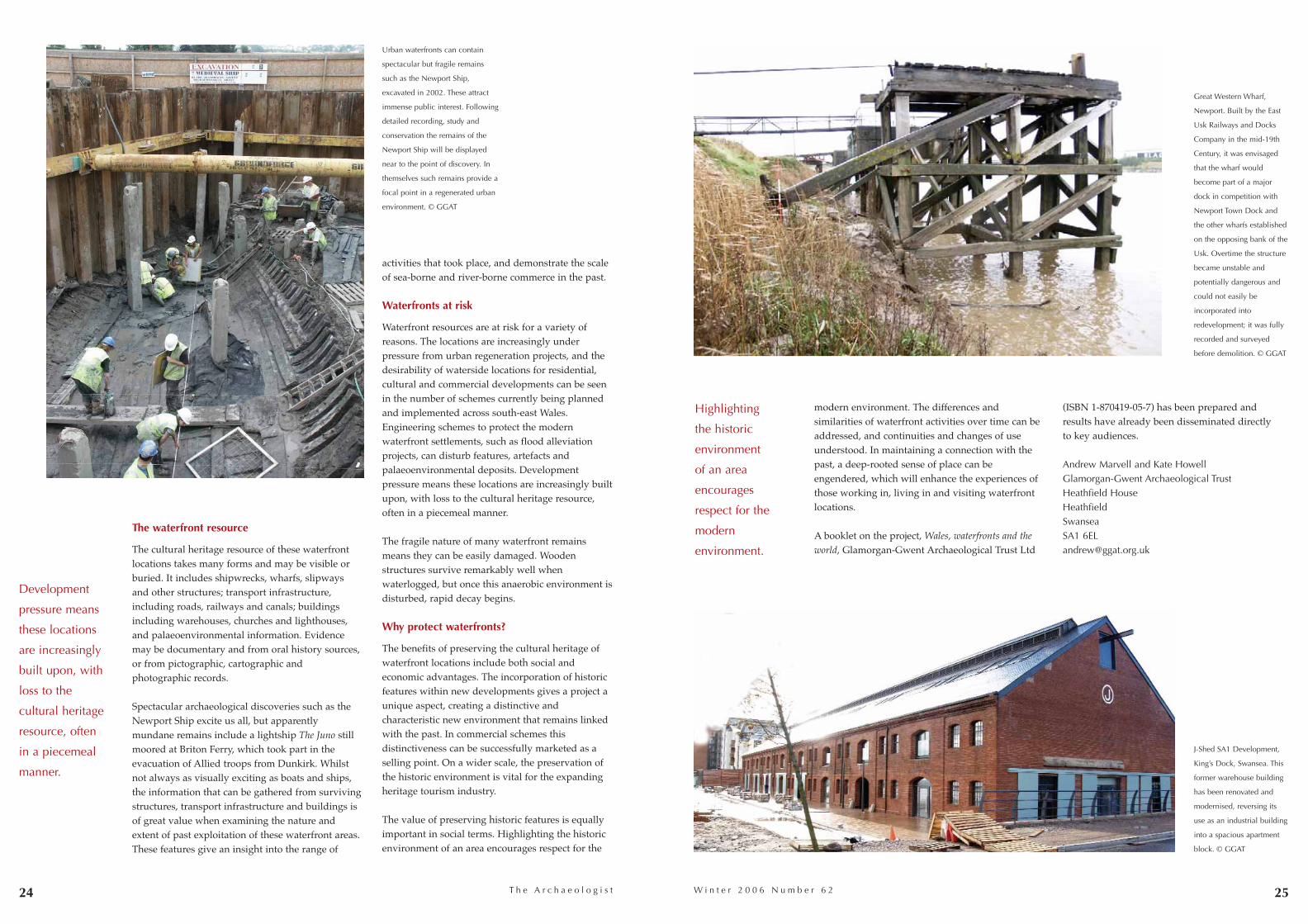
Urban waterfronts can contain
spectacular but fragile remains
such as the Newport Ship,
excavated in 2002. These attract
immense public interest. Following
detailed recording, study and
conservation the remains of the
Newport Ship will be displayed
near to the point of discovery. In
themselves such remains provide a
focal point in a regenerated urban
environment. © GGAT
Development
pressure means
these locations
are increasingly
built upon, with
loss to the
cultural heritage
resource, often
in a piecemeal
manner.
Highlighting
the historic
environment
of an area
encourages
respect for the
modern
environment.
Great Western Wharf,
Newport. Built by the East
Usk Railways and Docks
Company in the mid-19th
Century, it was envisaged
that the wharf would
become part of a major
dock in competition with
Newport Town Dock and
the other wharfs established
on the opposing bank of the
Usk. Overtime the structure
became unstable and
potentially dangerous and
could not easily be
incorporated into
redevelopment; it was fully
recorded and surveyed
before demolition. © GGAT
J-Shed SA1 Development,
King’s Dock, Swansea. This
former warehouse building
has been renovated and
modernised, reversing its
use as an industrial building
into a spacious apartment
block. © GGAT
W i n t e r 2 0 0 6 N u m b e r 6 2
26 27T h e A r c h a e o l o g i s t
Almost from its inception in 1931, the National Trustfor Scotland has been involved in saving smallhistoric houses in declining Scottish burghs. In theprocess it has transformed historic towns such asDunkeld, Culross, the East Neuk of Fife villages –and the vibrant communities that inhabit them. TheLittle Houses Improvement Scheme (LHIS) began inthe 1950s with a simple idea. Take over a historicbuilding in need of TLC; find the resources andrestore it to the conservation standards of the day;then sell it on – almost inevitably at a loss – with aConservation Agreement or Burden that legallyprotects its special qualities in the future. The Fifevillage of Culross is one of the best examples of thisregeneration; a concerted effort led to changing adeclining community into one that has become soproud of itself its burghers are proposing a realisticbid for World Heritage Site status.
Recording and rewardsMore recent projects include a significantarchaeological component, and the scheme has beenimportant in raising the profile of buildingsarchaeology in Scotland. The experience at Bo’nessis typical: a semi-derelict and unvalued structureturns out to be far more interesting than anyonecould have imagined. The challenge is to make thecase for this level of recording to the rest of thebuildings preservation trust movement, despite theproblems of raising even more money. The reward,of course, is that the enhanced historical importanceof the building leads to even greater civic pride, oneof the main aims of such projects.
Dymock’s burning secretDymock’s Building in Bo’ness, once ‘Glasgow’s eastport’, includes a 17th-century merchant’s house withfine panelled rooms, a yard with arched entranceand lean-to stables. With its central location, thedilapidated but historically important building wasideal for conversion through LHIS to amenityhousing for the elderly.
Kirkdale Archaeology Ltd undertook detailedrecording of the upstanding building and excavatedwhere building work would destroy burieddeposits. The results have enhanced ourunderstanding of the town as well as transformingour appreciation of the property, and have heavilyinfluenced the final conversion scheme. The yardarea revealed a sequence of intact cobbled surfaces,with paving and post pads indicating 18th-centurycart sheds and stables. It became evident that manysurrounding structures had been reused forindustrial purposes. During the 19th century twocast-iron pans, about 2m diameter and 1m deep,were dug behind the house. These were initiallythought to be tanks for the settling and separation ofwhale oil products, but chemical analysis of theresidues failed to confirm this interpretation.Another possibility is that they were ‘barking pots’used to steep fishing nets. The base of one of theenigmatic pans was recovered and incorporated inthe final layout of the courtyard.
Excavation west of the house revealed industrialwaste that had been dumped to extend the naturalshoreline, resulting in construction of the town’sWest Pier around 1636. This dump underlay theearliest parts of the merchant’s house and sealedremains of an unsuspected massive, heavily burntstone structure.
Roughly spade-shaped in plan, this structure wasup to 9m across, with walls 1.8m thick surviving to
1.5m. There were two angled embrasures and whatappeared to be flues in the straight southern wall.Heavily heat-affected, the walls of beach stonesoverlay burnt sandy deposits, suggesting thestructure had been used as a kiln or furnace. It waspossibly a salt-pan, a common structure aroundBo’ness in the 16th century.
Archaeological work always attracts public interestand this project was no exception. Open days werewell attended and primary schools took part in aprogramme on ‘How to be a good archaeologist’(www.ntseducation.org.uk). The local communitytook no time to warm to the project and to re-establish ownership of the town’s history.
Detailed recording and research have provided aremarkable insight not just into this structure butthe origins and development of the late medievalburgh of Bo’ness. The building is now a majorasset rather than a liability, and a furthersubstantial restoration project of the nearbyHippodrome Cinema has become the next step inchanging the fortunes of the historic town
Little Houses: the bookThe fascinating history of the politics andpracticalities of NTS work with little houses overits first 75 years is told in Little Houses: the NationalTrust for Scotland’s Improvement Scheme for SmallHistoric Homes by Diane Watters and MilesGlendinning, available from www.rcahms.gov.uk/publications.html.
Robin TurnerHead of Archaeology, National Trust for Scotland
Derek AlexanderNTS West Region Archaeologist, National Trust forScotland
Little Houses make
a big differencein historic small towns
Robin Turner and Derek Alexander
W i n t e r 2 0 0 6 N u m b e r 6 2
Fife Harling stamp, featuring an LHIS
restoration of The Nunnery, Culross
Dymock’s Building: north façade,
before restoration. © NTS
Dymock’s Building: north façade,
after restoration. © NTS
Dymock’s Building:
iron pans, possibly
for steeping fishing
nets. © NTS
Dymock’s Building:
16th-century salt
kiln? © NTS
With several important projects in train, LHIS remains a keyway in which NTS fulfils its statutory aim of promotingconservation, access and enjoyment of Scotland’s heritage.Archaeology, both standing and below ground, is now anintegral part of the process, showing people that they can andshould be proud of their local heritage.
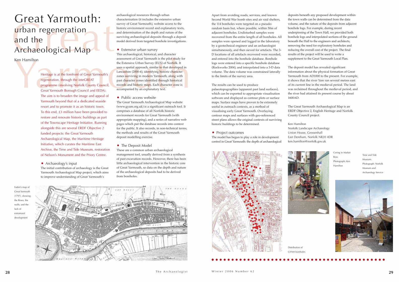
GreatYarmouth
28 29
Heritage is at the forefront of Great Yarmouth’s
regeneration, through the inteGREAT
programme (involving Norfolk County Council,
Great Yarmouth Borough Council and EEDA).
The aim is to broaden the image and appeal of
Yarmouth beyond that of a dedicated seaside
resort and to promote it as an historic town.
To this end, £3 million have been provided to
restore and renovate historic buildings as part
of the Townscape Heritage Initiative. Running
alongside this are several ERDF Objective 2
funded projects: the Great Yarmouth
Archaeological Map, the Maritime Heritage
Initiative, which curates the Maritime East
Archive, the Time and Tide Museum, restoration
of Nelson’s Monument and the Priory Centre.
• Archaeology’s inputThe initial contribution of archaeology is the GreatYarmouth Archaeological Map project, which aimsto improve understanding of Great Yarmouth’s
archaeological resources through urbancharacterisation (it includes the extensive urbansurvey of Great Yarmouth), website access to thehistoric environment record and explanatory texts,and determination of the depth and nature of thesurviving archaeological deposits through a depositmodel derived from targeted borehole investigations.
• Extensive urban surveyThis archaeological, historical, and characterassessment of Great Yarmouth is the pilot study forthe Extensive Urban Survey (EUS) of Norfolk. Ituses a spatial approach, similar to that developed inLancashire (2000-4), identifying historic characterzones surviving in modern Yarmouth, along withpast character zones identified through historicalrecords and historic maps. Each character zone isaccompanied by an explanatory text.
• Public access websiteThe Great Yarmouth Archaeological Map website(www.gyam.org.uk) is a significant outreach tool. Itcomprises a database of all Norfolk historicenvironment records for Great Yarmouth (withappropriate mapping), and a series of narrative webpages which put the database records into contextfor the public. It also records, in non-technical terms,the methods and results of the Great Yarmouthdeposit modelling exercise.
• The Deposit ModelThese are a common urban archaeologicalmanagement tool, usually derived from a synthesisof past excavation records. However, there has beenlittle archaeological intervention in the historic coreof Great Yarmouth, so data on the depth and natureof the archaeological deposits had to be derivedfrom boreholes.
Apart from avoiding roads, services, and knownSecond World War bomb sites and air raid shelters,the 114 boreholes were targeted on a pseudo-random basis but, where possible, within 50m ofadjacent boreholes. Undisturbed samples wererecovered from the entire length of all boreholes. Allsamples were opened and logged in the laboratoryby a geotechnical engineer and an archaeologistsimultaneously, and then sieved for artefacts. The 3-D locations of all artefacts recovered were recorded,and entered into the borehole database. Boreholelogs were entered into a specific borehole database(Rockworks 2004), and interpolated into a 3-D datavolume. The data volume was constrained laterallyto the limits of the survey area.
The results can be used to producepalaeotopographies (apparent past land surfaces),which can be exported to appropriate visualisationsoftware and displayed as contour plots or surfacemaps. Surface maps have proven to be extremelyuseful in outreach contexts, as a method ofvisualising early Great Yarmouth. Overlayingcontour maps and surfaces with geo-referencedstreet plans allows the original contexts of survivinghistoric buildings to be determined.
• Project outcomesThe model has begun to play a role in developmentcontrol in Great Yarmouth: the depth of archaeological
deposits beneath any proposed development withinthe town walls can be determined from the datavolume, and the nature of the deposits from adjacentborehole logs. For example, during recentunderpinning of the Town Hall, we provided bothborehole logs and interpolated sections of the groundbeneath the Hall to the engineers and architects,removing the need for exploratory boreholes andreducing the overall cost of the project. The finalresults of the project will be used to write asupplement to the Great Yarmouth Local Plan.
The deposit model has revealed significantinformation about the physical formation of GreatYarmouth from AD1000 to the present. For example,it shows that the river Yare ran several metres eastof its current line in the medieval period. The landwas reclaimed throughout the medieval period, andthe river had attained its present course by about1600AD.
The Great Yarmouth Archaeological Map is anERDF Objective 2, English Heritage and NorfolkCounty Council project.
Ken HamiltonNorfolk Landscape ArchaeologyUnion House, GressenhallEast Dereham, Norfolk NR20 [email protected]
T h e A r c h a e o l o g i s t
Great Yarmouth: urban regeneration and the Archaeological MapKen Hamilton
W i n t e r 2 0 0 6 N u m b e r 6 2
Coring in Market
Row.
Photograph: Ken
Hamilton
Faden’s map of
Great Yarmouth
(1797), showing
the Rows, the
walls, and the
lack of
extramural
development
Distribution of
GYAM boreholes
Time and Tide
Museum.
Photograph: Norfolk
Museum and
Archaeology Service
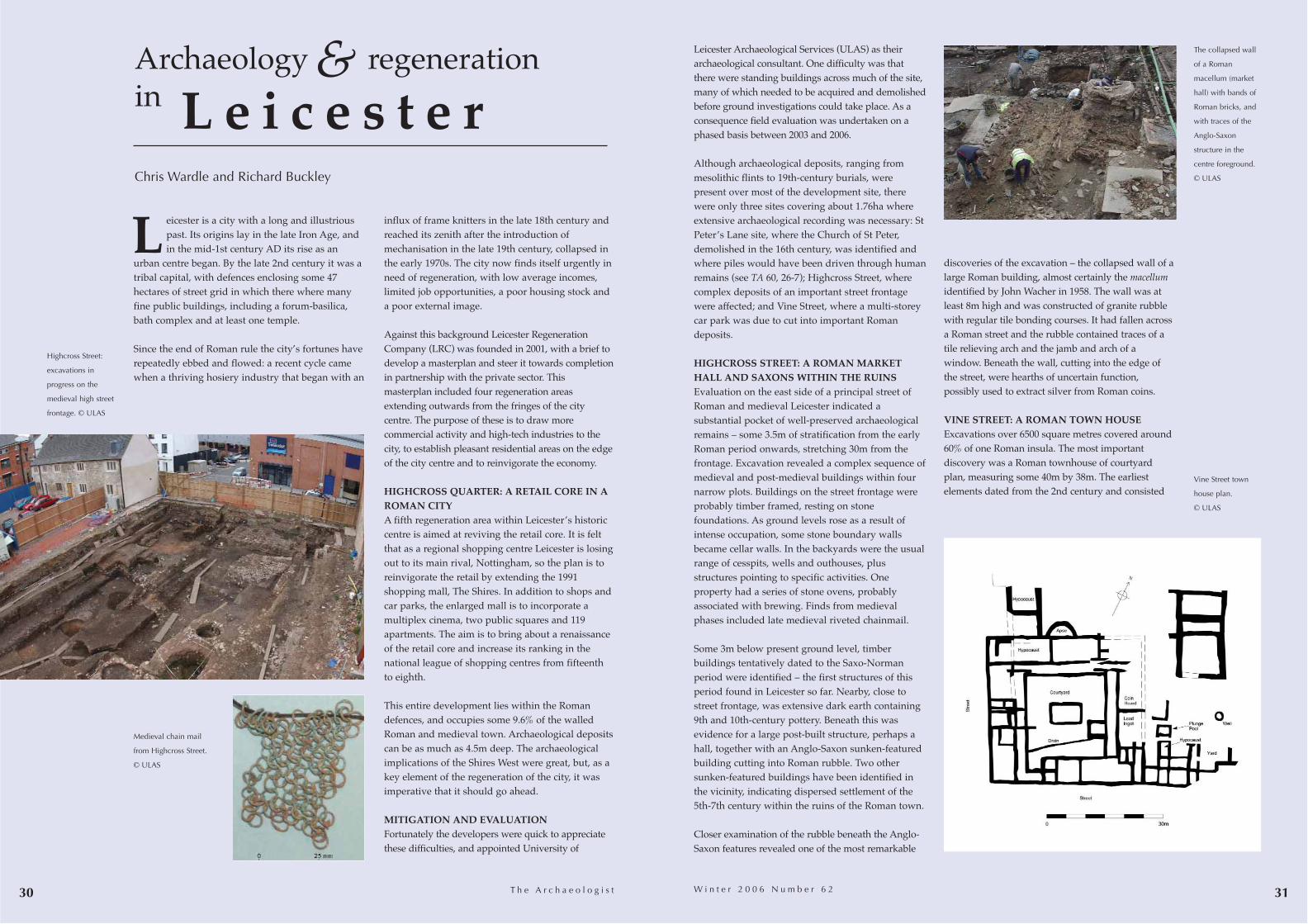
30 31
Leicester Archaeological Services (ULAS) as theirarchaeological consultant. One difficulty was thatthere were standing buildings across much of the site,many of which needed to be acquired and demolishedbefore ground investigations could take place. As aconsequence field evaluation was undertaken on aphased basis between 2003 and 2006.
Although archaeological deposits, ranging frommesolithic flints to 19th-century burials, werepresent over most of the development site, therewere only three sites covering about 1.76ha whereextensive archaeological recording was necessary: StPeter’s Lane site, where the Church of St Peter,demolished in the 16th century, was identified andwhere piles would have been driven through humanremains (see TA 60, 26-7); Highcross Street, wherecomplex deposits of an important street frontagewere affected; and Vine Street, where a multi-storeycar park was due to cut into important Romandeposits.
HIGHCROSS STREET: A ROMAN MARKETHALL AND SAXONS WITHIN THE RUINS Evaluation on the east side of a principal street ofRoman and medieval Leicester indicated asubstantial pocket of well-preserved archaeologicalremains – some 3.5m of stratification from the earlyRoman period onwards, stretching 30m from thefrontage. Excavation revealed a complex sequence ofmedieval and post-medieval buildings within fournarrow plots. Buildings on the street frontage wereprobably timber framed, resting on stonefoundations. As ground levels rose as a result ofintense occupation, some stone boundary wallsbecame cellar walls. In the backyards were the usualrange of cesspits, wells and outhouses, plusstructures pointing to specific activities. Oneproperty had a series of stone ovens, probablyassociated with brewing. Finds from medievalphases included late medieval riveted chainmail.
Some 3m below present ground level, timberbuildings tentatively dated to the Saxo-Normanperiod were identified – the first structures of thisperiod found in Leicester so far. Nearby, close tostreet frontage, was extensive dark earth containing9th and 10th-century pottery. Beneath this wasevidence for a large post-built structure, perhaps ahall, together with an Anglo-Saxon sunken-featuredbuilding cutting into Roman rubble. Two othersunken-featured buildings have been identified inthe vicinity, indicating dispersed settlement of the5th-7th century within the ruins of the Roman town.
Closer examination of the rubble beneath the Anglo-Saxon features revealed one of the most remarkable
T h e A r c h a e o l o g i s t
eicester is a city with a long and illustriouspast. Its origins lay in the late Iron Age, andin the mid-1st century AD its rise as an
urban centre began. By the late 2nd century it was atribal capital, with defences enclosing some 47hectares of street grid in which there where manyfine public buildings, including a forum-basilica,bath complex and at least one temple.
Since the end of Roman rule the city’s fortunes haverepeatedly ebbed and flowed: a recent cycle camewhen a thriving hosiery industry that began with an
influx of frame knitters in the late 18th century andreached its zenith after the introduction ofmechanisation in the late 19th century, collapsed inthe early 1970s. The city now finds itself urgently inneed of regeneration, with low average incomes,limited job opportunities, a poor housing stock anda poor external image.
Against this background Leicester RegenerationCompany (LRC) was founded in 2001, with a brief todevelop a masterplan and steer it towards completionin partnership with the private sector. Thismasterplan included four regeneration areasextending outwards from the fringes of the citycentre. The purpose of these is to draw morecommercial activity and high-tech industries to thecity, to establish pleasant residential areas on the edgeof the city centre and to reinvigorate the economy.
HIGHCROSS QUARTER: A RETAIL CORE IN AROMAN CITYA fifth regeneration area within Leicester’s historiccentre is aimed at reviving the retail core. It is feltthat as a regional shopping centre Leicester is losingout to its main rival, Nottingham, so the plan is toreinvigorate the retail by extending the 1991shopping mall, The Shires. In addition to shops andcar parks, the enlarged mall is to incorporate amultiplex cinema, two public squares and 119apartments. The aim is to bring about a renaissanceof the retail core and increase its ranking in thenational league of shopping centres from fifteenthto eighth.
This entire development lies within the Romandefences, and occupies some 9.6% of the walledRoman and medieval town. Archaeological depositscan be as much as 4.5m deep. The archaeologicalimplications of the Shires West were great, but, as akey element of the regeneration of the city, it wasimperative that it should go ahead.
MITIGATION AND EVALUATIONFortunately the developers were quick to appreciatethese difficulties, and appointed University of
discoveries of the excavation – the collapsed wall of alarge Roman building, almost certainly the macellumidentified by John Wacher in 1958. The wall was atleast 8m high and was constructed of granite rubblewith regular tile bonding courses. It had fallen acrossa Roman street and the rubble contained traces of atile relieving arch and the jamb and arch of awindow. Beneath the wall, cutting into the edge ofthe street, were hearths of uncertain function,possibly used to extract silver from Roman coins.
VINE STREET: A ROMAN TOWN HOUSEExcavations over 6500 square metres covered around60% of one Roman insula. The most importantdiscovery was a Roman townhouse of courtyardplan, measuring some 40m by 38m. The earliestelements dated from the 2nd century and consisted
W i n t e r 2 0 0 6 N u m b e r 6 2
Archaeology regeneration in
Chris Wardle and Richard Buckley
Medieval chain mail
from Highcross Street.
© ULAS
Highcross Street:
excavations in
progress on the
medieval high street
frontage. © ULAS
L e i c e s t e r& The collapsed wall
of a Roman
macellum (market
hall) with bands of
Roman bricks, and
with traces of the
Anglo-Saxon
structure in the
centre foreground.
© ULAS
Vine Street town
house plan.
© ULAS
L
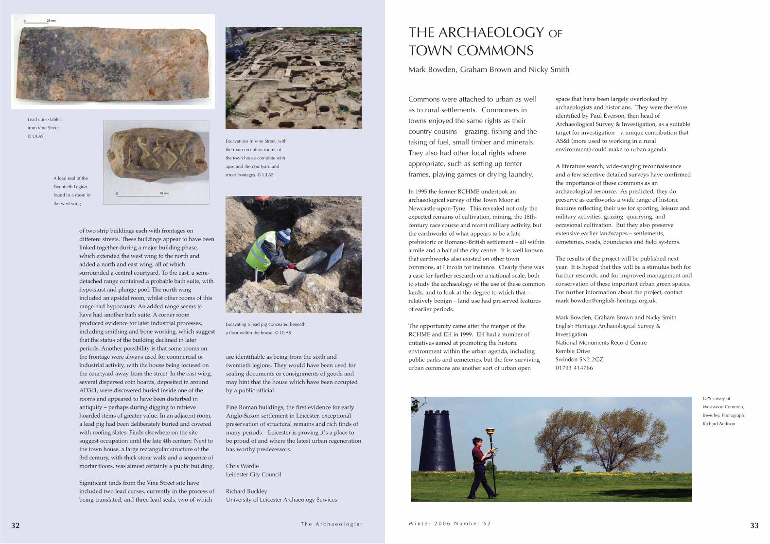
3332
of two strip buildings each with frontages ondifferent streets. These buildings appear to have beenlinked together during a major building phase,which extended the west wing to the north andadded a north and east wing, all of whichsurrounded a central courtyard. To the east, a semi-detached range contained a probable bath suite, withhypocaust and plunge pool. The north wingincluded an apsidal room, whilst other rooms of thisrange had hypocausts. An added range seems tohave had another bath suite. A corner roomproduced evidence for later industrial processes,including smithing and bone working, which suggestthat the status of the building declined in laterperiods. Another possibility is that some rooms onthe frontage were always used for commercial orindustrial activity, with the house being focused onthe courtyard away from the street. In the east wing,several dispersed coin hoards, deposited in aroundAD341, were discovered buried inside one of therooms and appeared to have been disturbed inantiquity – perhaps during digging to retrievehoarded items of greater value. In an adjacent room,a lead pig had been deliberately buried and coveredwith roofing slates. Finds elsewhere on the sitesuggest occupation until the late 4th century. Next tothe town house, a large rectangular structure of the3rd century, with thick stone walls and a sequence ofmortar floors, was almost certainly a public building.
Significant finds from the Vine Street site haveincluded two lead curses, currently in the process ofbeing translated, and three lead seals, two of which
are identifiable as being from the sixth andtwentieth legions. They would have been used forsealing documents or consignments of goods andmay hint that the house which have been occupiedby a public official.
Fine Roman buildings, the first evidence for earlyAnglo-Saxon settlement in Leicester, exceptionalpreservation of structural remains and rich finds ofmany periods – Leicester is proving it’s a place tobe proud of and where the latest urban regenerationhas worthy predecessors.
Chris WardleLeicester City Council
Richard BuckleyUniversity of Leicester Archaeology Services
T h e A r c h a e o l o g i s t
Commons were attached to urban as well
as to rural settlements. Commoners in
towns enjoyed the same rights as their
country cousins – grazing, fishing and the
taking of fuel, small timber and minerals.
They also had other local rights where
appropriate, such as setting up tenter
frames, playing games or drying laundry.
In 1995 the former RCHME undertook anarchaeological survey of the Town Moor atNewcastle-upon-Tyne. This revealed not only theexpected remains of cultivation, mining, the 18th-century race course and recent military activity, butthe earthworks of what appears to be a lateprehistoric or Romano-British settlement – all withina mile and a half of the city centre. It is well knownthat earthworks also existed on other towncommons, at Lincoln for instance. Clearly there wasa case for further research on a national scale, bothto study the archaeology of the use of these commonlands, and to look at the degree to which that –relatively benign – land use had preserved featuresof earlier periods.
The opportunity came after the merger of theRCHME and EH in 1999. EH had a number ofinitiatives aimed at promoting the historicenvironment within the urban agenda, includingpublic parks and cemeteries, but the few survivingurban commons are another sort of urban open
space that have been largely overlooked byarchaeologists and historians. They were thereforeidentified by Paul Everson, then head ofArchaeological Survey & Investigation, as a suitabletarget for investigation – a unique contribution thatAS&I (more used to working in a ruralenvironment) could make to urban agenda.
A literature search, wide-ranging reconnaissanceand a few selective detailed surveys have confirmedthe importance of these commons as anarchaeological resource. As predicted, they dopreserve as earthworks a wide range of historicfeatures reflecting their use for sporting, leisure andmilitary activities, grazing, quarrying, andoccasional cultivation. But they also preserveextensive earlier landscapes – settlements,cemeteries, roads, boundaries and field systems.
The results of the project will be published nextyear. It is hoped that this will be a stimulus both forfurther research, and for improved management andconservation of these important urban green spaces.For further information about the project, [email protected].
Mark Bowden, Graham Brown and Nicky SmithEnglish Heritage Archaeological Survey &InvestigationNational Monuments Record CentreKemble DriveSwindon SN2 2GZ01793 414766
GPS survey of
Westwood Common,
Beverley. Photograph:
Richard Addison
W i n t e r 2 0 0 6 N u m b e r 6 2
THE ARCHAEOLOGY OF
TOWN COMMONSMark Bowden, Graham Brown and Nicky Smith
Excavations in Vine Street, with
the main reception rooms of
the town house complete with
apse and the courtyard and
street frontages. © ULAS
Lead curse tablet
from Vine Street.
© ULAS
Excavating a lead pig concealed beneath
a floor within the house. © ULAS
A lead seal of the
Twentieth Legion
found in a room in
the west wing

34 35
successful tender was implemented through an ICEContract for Archaeological Investigation. Thecollaboration successfully combined WHEAS’extensive local knowledge and specialist finds andenvironmental teams with Cotswold Archaeology’sregional and logistical expertise.
REVEALING HISTORYThe excavation provided the first certain evidence ofa Roman road linking the small town to a presumedford or bridge across the Severn at the end of whatlater became Newport Street. Importantly, this roadhas been shown to have continued in use until amedieval bridge was built and the road shiftedslightly to its current alignment. Later remainsincluded numerous medieval and post-medievalbuildings fronting the street, with ovens, hearthsand other industrial remains providing evidence forleatherworking, iron-smithing, and the weaving anddyeing of cloth in back-plots between the medievalbridge and the commercial heart of the city. Thesurviving foundations of 19th-century courts packedinto the former back plot areas, reflected the rapiddecline in prosperity of the area following theconstruction in 1781 of a new bridge a short distancedownstream, effectively relegating Newport Streetto a minor back lane.
Archaeological input into the regeneration projecthas continued beyond the completion of site work,with the digitised excavation plan providing ablueprint for certain aspects of the newdevelopment, and with the direct involvement ofarchaeological expertise in designing plaques thatwill inform the public of the historical context of the site.
Since completion of fieldwork, joint working on thepost-excavation assessment has continued alongsimilar lines. The collaborative approach has bothfacilitated this element of the regeneration ofWorcester’s riverside and yielded a considerablebody of important archaeological information.Hopefully it has also established a precedent thatwill allow greater exchange of knowledge betweenRAOs and provide more stable employment forarchaeologists within the area.
Robin Jackson Worcestershire Historic Environment and ArchaeologyService
Martin WattsCotswold Archaeology
James DinnWorcester City Council
T h e A r c h a e o l o g i s t
Worcester, with aspirations to develop as a ‘firstrank cathedral and university city’, has several areaswithin and around its historic centre identified forre-development over the next few years. Some ofthese areas, including the Newport Street site, wereonce part of the historic townscape but were clearedin the mid 20th century to become surface car parks.Others are the remains of 19th-century industrialcomplexes (for instance the Royal WorcesterPorcelain factory). Proposed developments includeinnovative riverside re-development of the formercity hospital and a council depot into a secondcampus for the University of Worcester, linked to a‘world class joint academic and public library andhistory centre’.
PLANNING FOR PRESERVATION At Newport Street, an opportunity arose forarchaeologists to examine the largest single areaever investigated within the medieval city walls, inthe context of a strategy which retained the majorityof archaeological remains in situ. The site wasidentified as having importance for the medievaland early post-medieval periods (it included some14 former property holdings), with a high potentialfor significant Roman deposits. ArchenfieldArchaeology, consultants for the project, undertooka desk-based assessment, and brought inWorcestershire Historic Environment andArchaeology Service (WHEAS) to undertake fieldevaluation, leading to a series of archaeologicalplanning conditions. These included fullarchaeological excavation to the formation level fordevelopment, sample excavation of deeper deposits,piled foundations, and monitoring of the impact ofdevelopment on groundwater. Addressing a rangeof research priorities identified in a draft researchframework, developed as part of the UrbanArchaeological Strategy, was central to themitigation strategy.
COMBINED FORCESA rapid start and large staff were required by thedevelopers Cabot Homes, so WHEAS joined forceswith fellow RAO, Cotswold Archaeology, and their
WORCESTER:
Urban regeneration and archaeologicalpartnerships
Robin Jackson, Martin Watts
and James Dinn
Aerial view of the
excavations.
© Mike Glyde
Archaeologists from
Cotswold Archaeology
and WHEAS excavating a
late medieval oven or dye-
vat base. © WHEAS
12th/13th-century cellar
on Newport Street – the
scales are sitting on a
Roman road surface
revealed below its floor.
© WHEAS
W i n t e r 2 0 0 6 N u m b e r 6 2

Salford
36 37T h e A r c h a e o l o g i s t
probably occupied by garden plots, orchards, orcrofts. A number of medieval buildings surviveduntil the 20th century. The market was held on therectangular village green, where there was a marketcross, stocks and the town pump. Alongside was theexchange building or courthouse, in which both thePortmanmote and the Salford Hundred Court sat.
Car parks and derelictionBy 1787-94 industrialisation was changing the town’scharacter. Salford was extending beyond its originalnucleus and the medieval ‘triangle’ was starting toinfill. By 1848 there were dense concentrations ofworkers’ housing, with terraces of back-to-backdwellings, chapels, public houses, and variousindustrial works. A size works, foundry, brewery,tannery, print works and cotton mill were all presentin a very small area. The 20th century saw closure ofthe railway station, industrial decline and slumclearance, with decay leading to an area dominatedby car parks and dereliction. Remarkably, therectangular market place is still discernible at thejunction of Greengate and Gravel Lane.
Rediscoveringmedieval Salford:archaeology andurban regenerationNorman Redhead
Salford City Council has recently produceda master plan for the regeneration ofGreengate, an area of dereliction justacross the River Irwell from the medievalcore of Manchester and the vibrantshopping centre there. This area was oncethe medieval core of Salford, yet nobuildings survive from before the 19thcentury. This scheme has presented aunique opportunity to restore the historicidentity of Salford.
Salford was already an important place in 1086, wasgranted a market in 1228 and by 1230 a charter hadgiven it borough status. A survey of 1346 records129 burgages, but its economic base was only inagriculture and its market declined in the post-medieval period. Until recently knowledge aboutmedieval Salford rested largely upon maps from thepost-medieval period, which show that the basiclayout changed little until the late 18th century. Thetown plan was an irregular triangle, the interior
Regeneration Master PlanThe draft regeneration master plan made littlereference to the historic legacy of the Greengatearea, an oversight identified by the GreaterManchester Archaeological Unit (GMAU) andSalford Conservation Officer. Their amendedstrategy incorporated
• the market place itself, with the cross (and stocks)restored as an iconic landmark structure.Information boards would tell the story of themedieval borough and its later development,illustrated with finds and excavated features
• the other key focal point will be Collier StreetBaths, a Grade II listed building designed byThomas Waterhouse and opened in 1856, whichis on English Heritage’s Buildings At RiskRegister. It is proposed that some 20th-centurybuildings are demolished to open up the fineItalianate façade of this neglected building,allowing it to become an outstanding landmarkbuilding within the new development. The Bathsshould be restored, with commercial and publicuse, one possibility for the latter being anexhibition space telling the story of Greengatearea’s history, archaeology, and regeneration
• a new boulevard between the market place andthe Baths will link key historical focal points forthe regeneration scheme: the Baths to representthe industrial period and the market place andcross for the medieval period. The Baths andCross would be landmark features at either endof the boulevard
• a new park, Greengate, forming a green heart forthe regeneration area adjacent to the marketplace, is already featured in the master plan.GMAU have flagged up the potential forengaging local schools and residents in acommunity archaeology project here, giving asense of ‘ownership’ in the new development
• an archaeological desk-based assessment that willfacilitate exposure and presentation of keyarchaeological features within the designedlandscape, provide an historical andarchaeological framework for informationboards, educational material, press releases etcand informing proposals for communityarchaeological involvement
Development will have a major impact on thearchaeological resource, particularly wherebasement car parking is required. There is alreadysome truncation from 20th-century activities but the
archaeological potential is considerable, with remainsof medieval burgage plots, houses, and industrialremains and workers’ housing from later periodsalready evident from three excavations in theregeneration area. These excavations have providedthe opportunity to engage with key stakeholders, andcouncillors are excited at the prospect of restoringSalford’s historic identity. Collaboration with theSalford University Centre for Virtual Environmentwill add a new dimension to presentation of thearchaeological resource.
It is still early days. An Urban RegenerationCorporation has been established, planning guidanceproduced by Salford City Council and the masterplan has been revised. The regeneration project willre-connect the two cities and provide a new andvibrant city centre quarter, with its own distinctiveidentity based on the restoration of Salford’s medievalpast.
Norman RedheadAssistant County ArchaeologistGreater Manchester Archaeological Unit
W i n t e r 2 0 0 6 N u m b e r 6 2
Salford’s medieval market
place today, with
Manchester Cathedral and
Arndale Shopping Centre
beyond the railway viaduct
on the left
A plan of Manchester
and Salford c 1650The Greengate Towers
development, partly
excavated by Oxford
Archaeology North in 2006,
showing a row of cellared
dwellings. The back yards
lay over a deep black
garden soil which yielded a
substantial assemblage of
17th/18th century pottery. A
13/14th century boundary
ditch runs across the top of
the excavation area
Part of the Abito
development site, excavated
by the University of
Manchester Archaeological
Unit in 2005. Remains
ranged from 13th-century
rubbish pits and property
boundaries to industrial
period back-to-back and
blind back workers’ housing
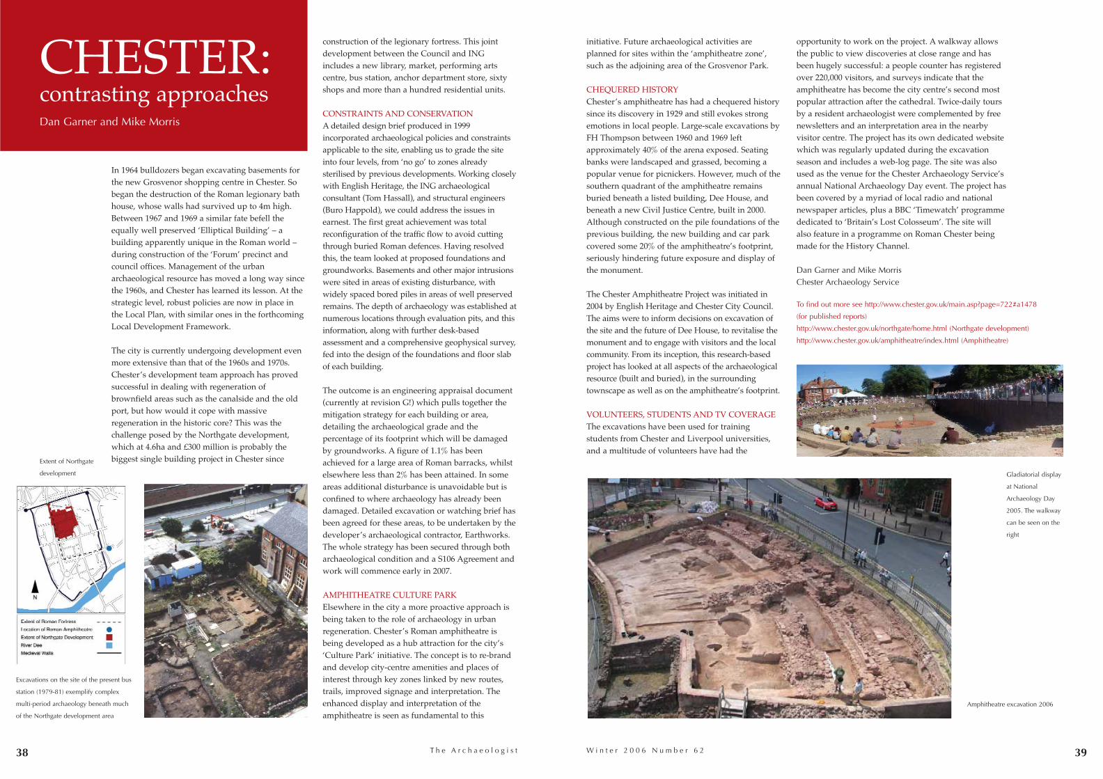
39W i n t e r 2 0 0 6 N u m b e r 6 238
construction of the legionary fortress. This jointdevelopment between the Council and INGincludes a new library, market, performing artscentre, bus station, anchor department store, sixtyshops and more than a hundred residential units.
CONSTRAINTS AND CONSERVATIONA detailed design brief produced in 1999incorporated archaeological policies and constraintsapplicable to the site, enabling us to grade the siteinto four levels, from ‘no go’ to zones alreadysterilised by previous developments. Working closelywith English Heritage, the ING archaeologicalconsultant (Tom Hassall), and structural engineers(Buro Happold), we could address the issues inearnest. The first great achievement was totalreconfiguration of the traffic flow to avoid cuttingthrough buried Roman defences. Having resolvedthis, the team looked at proposed foundations andgroundworks. Basements and other major intrusionswere sited in areas of existing disturbance, withwidely spaced bored piles in areas of well preservedremains. The depth of archaeology was established atnumerous locations through evaluation pits, and thisinformation, along with further desk-basedassessment and a comprehensive geophysical survey,fed into the design of the foundations and floor slabof each building.
The outcome is an engineering appraisal document(currently at revision G!) which pulls together themitigation strategy for each building or area,detailing the archaeological grade and thepercentage of its footprint which will be damagedby groundworks. A figure of 1.1% has beenachieved for a large area of Roman barracks, whilstelsewhere less than 2% has been attained. In someareas additional disturbance is unavoidable but isconfined to where archaeology has already beendamaged. Detailed excavation or watching brief hasbeen agreed for these areas, to be undertaken by thedeveloper’s archaeological contractor, Earthworks.The whole strategy has been secured through botharchaeological condition and a S106 Agreement andwork will commence early in 2007.
AMPHITHEATRE CULTURE PARKElsewhere in the city a more proactive approach isbeing taken to the role of archaeology in urbanregeneration. Chester’s Roman amphitheatre isbeing developed as a hub attraction for the city’s‘Culture Park’ initiative. The concept is to re-brandand develop city-centre amenities and places ofinterest through key zones linked by new routes,trails, improved signage and interpretation. Theenhanced display and interpretation of theamphitheatre is seen as fundamental to this
T h e A r c h a e o l o g i s t
In 1964 bulldozers began excavating basements forthe new Grosvenor shopping centre in Chester. Sobegan the destruction of the Roman legionary bathhouse, whose walls had survived up to 4m high.Between 1967 and 1969 a similar fate befell theequally well preserved ‘Elliptical Building’ – abuilding apparently unique in the Roman world –during construction of the ‘Forum’ precinct andcouncil offices. Management of the urbanarchaeological resource has moved a long way sincethe 1960s, and Chester has learned its lesson. At thestrategic level, robust policies are now in place inthe Local Plan, with similar ones in the forthcomingLocal Development Framework.
The city is currently undergoing development evenmore extensive than that of the 1960s and 1970s.Chester’s development team approach has provedsuccessful in dealing with regeneration ofbrownfield areas such as the canalside and the oldport, but how would it cope with massiveregeneration in the historic core? This was thechallenge posed by the Northgate development,which at 4.6ha and £300 million is probably thebiggest single building project in Chester since
CHESTER:contrasting approachesDan Garner and Mike Morris
initiative. Future archaeological activities areplanned for sites within the ‘amphitheatre zone’,such as the adjoining area of the Grosvenor Park.
CHEQUERED HISTORYChester’s amphitheatre has had a chequered historysince its discovery in 1929 and still evokes strongemotions in local people. Large-scale excavations byFH Thompson between 1960 and 1969 leftapproximately 40% of the arena exposed. Seatingbanks were landscaped and grassed, becoming apopular venue for picnickers. However, much of thesouthern quadrant of the amphitheatre remainsburied beneath a listed building, Dee House, andbeneath a new Civil Justice Centre, built in 2000.Although constructed on the pile foundations of theprevious building, the new building and car parkcovered some 20% of the amphitheatre’s footprint,seriously hindering future exposure and display ofthe monument.
The Chester Amphitheatre Project was initiated in2004 by English Heritage and Chester City Council.The aims were to inform decisions on excavation ofthe site and the future of Dee House, to revitalise themonument and to engage with visitors and the localcommunity. From its inception, this research-basedproject has looked at all aspects of the archaeologicalresource (built and buried), in the surroundingtownscape as well as on the amphitheatre’s footprint.
VOLUNTEERS, STUDENTS AND TV COVERAGEThe excavations have been used for trainingstudents from Chester and Liverpool universities,and a multitude of volunteers have had the
opportunity to work on the project. A walkway allowsthe public to view discoveries at close range and hasbeen hugely successful: a people counter has registeredover 220,000 visitors, and surveys indicate that theamphitheatre has become the city centre’s second mostpopular attraction after the cathedral. Twice-daily toursby a resident archaeologist were complemented by freenewsletters and an interpretation area in the nearbyvisitor centre. The project has its own dedicated websitewhich was regularly updated during the excavationseason and includes a web-log page. The site was alsoused as the venue for the Chester Archaeology Service’sannual National Archaeology Day event. The project hasbeen covered by a myriad of local radio and nationalnewspaper articles, plus a BBC ‘Timewatch’ programmededicated to ‘Britain’s Lost Colosseum’. The site willalso feature in a programme on Roman Chester beingmade for the History Channel.
Dan Garner and Mike MorrisChester Archaeology Service
To find out more see http://www.chester.gov.uk/main.asp?page=722#a1478
(for published reports)
http://www.chester.gov.uk/northgate/home.html (Northgate development)
http://www.chester.gov.uk/amphitheatre/index.html (Amphitheatre)
Extent of Northgate
development
Excavations on the site of the present bus
station (1979-81) exemplify complex
multi-period archaeology beneath much
of the Northgate development area
Amphitheatre excavation 2006
Gladiatorial display
at National
Archaeology Day
2005. The walkway
can be seen on the
right
A P P A G40 T h e A r c h a e o l o g i s t
unqualified support for a bored tunnel to removetraffic from Stonehenge, and commented on manymaritime heritage issues.
� Briefings and questionsIt has received briefings on the current HeritageProtection Review by Harry Reeves of DCMS, on thelooting of Baghdad Museum and measures toretrieve artefacts by Col Matthew Bogdanos of theUS military, on training museum staff as specialconstables for combating illicit trade in antiquitiesby Detective Sergeant Vernon Rapley of theMetropolitan Police, on recent excavations inWestminster Hall by Philip Emery of Giffords, and astatutory requirement for local authorities to providehistoric environment services (preventing furtherproblems like those in Northamptonshire). Mostrecently, Peter Beacham (English Heritage) and PeterHinton (IFA) talked about the imminent HeritageWhite Paper and how it should include restrictionson ploughing scheduled monuments and reforms toplanning guidance to confirm that it is reasonablefor the planning process to require opportunities forpublic participation, and to require commercialwork, where appropriate, to be conducted byaccredited historic environment professionals.
A recent briefing on aggregates and the AggregatesSustainability Levy Fund led to recommendations tostop siphoning of ASLF funds by DEFRA and formore flexible guidelines for pre-pre-applicationevaluation work to improve standards inarchaeological briefs. There have also been tours ofexcavations such as the Museum of London’scommunity excavations at Shoreditch and of WarwickRodwell’s work on Edward the Confessor’s tomb inWestminster Abbey. Suggestions for other tours thathelp inform MPs of the reality of archaeological worktoday are welcome.
Encouraged by APPAG, Parliamentary Questionshave been asked about:
• VAT on listed buildings
• concerns over the downgrading of archaeology
within English Heritage
• progress towards implementing the VallettaConvention
• steps taken to interest young people in archaeology
• success of targets for new users from prioritygroups of museums and heritage (we are doingrather better than the Arts)
• the collapse of the programme of scheduling ofmonuments while listing of buildings increases
• protection of historic wrecks (support has alsobeen rallied for an Early Day Motion on maritimeheritage)
• employment of conservation officers in localauthorities
There is a limit to what back benchers can do aboutany of these issues, but APPAG has proved to be auseful pressure group within parliament, and therehas been an observable improvement in the level ofdebate in parliament about archaeological issues.Those who speak on the subject do so with greaterknowledge and confidence, and are able to drawupon the expertise of the APPAG Advisory Group agroup of archaeologists (including the IFA’s Editor)who benefited from an informal but highlyprofessional course organised by Lord Redesdaleinto how Parliament works and how it should belobbied.
Perhaps the greatest impact that APPAG has had sofar is to reassure archaeologists that their cause isreflected and respected in parliament, to givearchaeology a distinct parliamentary voice (ratherthan being seen as a subset of heritage), and toprovide a channel through which archaeologicalissues can be brought to the attention ofparliamentarians and acted on as necessary.
For further information about APPAG, seewww.appag.org.uk or contact [email protected].
The All Party Parliamentary Archaeology Group(APPAG) was set up in 2001 by the LiberalDemocrat peer, Lord Rupert Redesdale, himself anarchaeology graduate (from Newcastle), effectivelysupported by Dai Morgan-Evans, then GeneralSecretary of the Society of Antiquaries of London.Rupert set up APPAG because he was concerned bythe near invisibility of archaeology in policystatements emanating from English Heritage andfrom Government about the heritage. He wasparticularly incensed by what he saw as an attemptto turn archaeology into an instrument of Laboursocial policy in Power of Place, a publication overwhich many people at English Heritage labouredlong and hard in an attempt to justify the socialvalue of archaeology but which Rupert createdheadlines by irreverently dismissing in the House ofLords as ‘a pile of pants’.
� Lords and MPsAPPAG is not quite the largest all party group inparliament (that is rumoured to be the All PartyParliamentary Beer Group), but with 77 MPs and 53peers it commands a good proportion of backbenchMembers and Lords (all party groups can includeministers and non-parliamentarians (known as‘strangers’ in parliamentary language) amongsttheir membership, but traditionally ministers do notjoin). The current officers are Lord (Colin) Renfrewof Kaimsthorn (Chairman), Lord Howarth ofNewport and Lord Montagu of Beaulieu (ViceChairmen), Lord (Rupert) Redesdale (Secretary) andTim Loughton MP (Treasurer).
� Key issuesThe first task was to try and pin down exactly whatthe key issues were that archaeologists most caredabout that could then be pursued through cross-party discussion and co-operation. Writtensubmissions were requested from national and localarchaeology groups, and a parliamentary inquirywas set up at which leading archaeologists gaveevidence on what they saw as the most pressingproblems.
These were summarised in a report published in
2003, and included problems that remain largelyunresolved. The headline issues were
• the need for an inter-departmental governmentcommittee on archaeology, serviced by a strongteam that could provide policy advice to DCMS
• amalgamation of current archaeologicalorganisations into a single non-governmentalorganisation to lobby for archaeology
• to improve pay and conditions forarchaeologists, with training supported byemployers. Only employers with high standardsshould be able to bid for contracts
• support for implementing the VallettaConvention, with provision for volunteerinvolvement built in
• statutory SMRs (now HERs or HES)
• revisions of the present system of competitivetendering for archaeological contracts
• abolition of Class Consents that allow ploughingof scheduled monuments
• long term support for finds liaison officers underthe Portable Antiquities Scheme
• boosting the study of archaeology, includingprehistory, in schools
• statutory provision for an adequate publicmuseum service
Thanks to Colin Renfrew’s close involvement withissues surrounding illicit trade in antiquities therehas been considerable lobbying on this issue,particularly in relation to the chaos in Iraq anddamage through looting there. The Group has alsobeen involved in campaigning over cuts to localauthority funding of archaeology, has supportedarchaeologists over problems with DCA licensing ofwork on human remains, discussed and gave
41W i n t e r 2 0 0 6 N u m b e r 6 2
T h e A l l P a r t y P a r l i a m e n t a r y A r c h a e o l o g y G r o u p Christopher Catling
Colin Renfrew, Chair of
APPAG
Rupert Redesdale, APPAG’s
Hon Secretary
Dai Morgan-Evans supported
the creation and early days
of APPAG
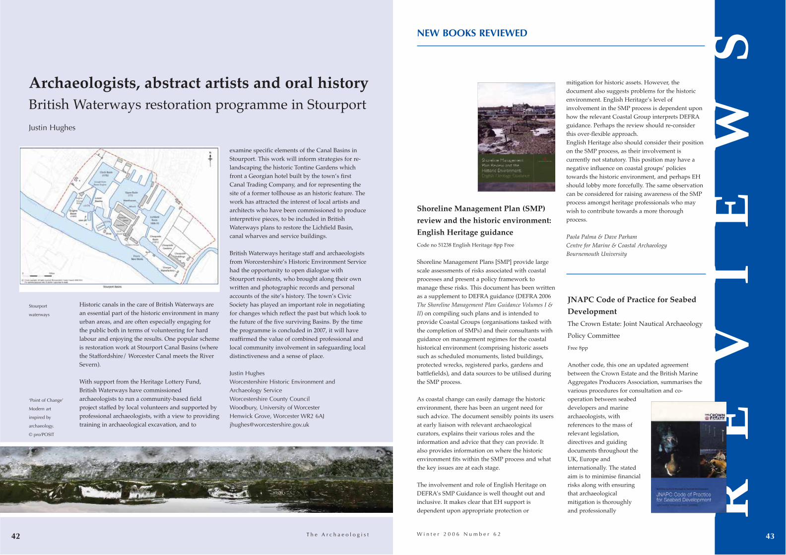
T h e A r c h a e o l o g i s t42
Shoreline Management Plan (SMP)
review and the historic environment:
English Heritage guidance
Code no 51238 English Heritage 8pp Free
Shoreline Management Plans [SMP] provide largescale assessments of risks associated with coastalprocesses and present a policy framework tomanage these risks. This document has been writtenas a supplement to DEFRA guidance (DEFRA 2006The Shoreline Management Plan Guidance Volumes I &II) on compiling such plans and is intended toprovide Coastal Groups (organisations tasked withthe completion of SMPs) and their consultants withguidance on management regimes for the coastalhistorical environment (comprising historic assetssuch as scheduled monuments, listed buildings,protected wrecks, registered parks, gardens andbattlefields), and data sources to be utilised duringthe SMP process.
As coastal change can easily damage the historicenvironment, there has been an urgent need forsuch advice. The document sensibly points its usersat early liaison with relevant archaeologicalcurators, explains their various roles and theinformation and advice that they can provide. Italso provides information on where the historicenvironment fits within the SMP process and whatthe key issues are at each stage.
The involvement and role of English Heritage onDEFRA’s SMP Guidance is well thought out andinclusive. It makes clear that EH support isdependent upon appropriate protection or
JNAPC Code of Practice for Seabed
Development
The Crown Estate: Joint Nautical Archaeology
Policy Committee
Free 8pp
Another code, this one an updated agreementbetween the Crown Estate and the British MarineAggregates Producers Association, summarises thevarious procedures for consultation and co-operation between seabeddevelopers and marinearchaeologists, withreferences to the mass ofrelevant legislation,directives and guidingdocuments throughout theUK, Europe andinternationally. The statedaim is to minimise financialrisks along with ensuringthat archaeologicalmitigation is thoroughlyand professionally
mitigation for historic assets. However, thedocument also suggests problems for the historicenvironment. English Heritage’s level ofinvolvement in the SMP process is dependent uponhow the relevant Coastal Group interprets DEFRAguidance. Perhaps the review should re-considerthis over-flexible approach. English Heritage also should consider their positionon the SMP process, as their involvement iscurrently not statutory. This position may have anegative influence on coastal groups’ policiestowards the historic environment, and perhaps EHshould lobby more forcefully. The same observationcan be considered for raising awareness of the SMPprocess amongst heritage professionals who maywish to contribute towards a more thoroughprocess.
Paola Palma & Dave ParhamCentre for Marine & Coastal Archaeology Bournemouth University
W i n t e r 2 0 0 6 N u m b e r 6 2
Historic canals in the care of British Waterways arean essential part of the historic environment in manyurban areas, and are often especially engaging forthe public both in terms of volunteering for hardlabour and enjoying the results. One popular schemeis restoration work at Stourport Canal Basins (wherethe Staffordshire/ Worcester Canal meets the RiverSevern).
With support from the Heritage Lottery Fund,British Waterways have commissionedarchaeologists to run a community-based fieldproject staffed by local volunteers and supported byprofessional archaeologists, with a view to providingtraining in archaeological excavation, and to
examine specific elements of the Canal Basins inStourport. This work will inform strategies for re-landscaping the historic Tontine Gardens whichfront a Georgian hotel built by the town’s first Canal Trading Company, and for representing thesite of a former tollhouse as an historic feature. Thework has attracted the interest of local artists andarchitects who have been commissioned to produceinterpretive pieces, to be included in BritishWaterways plans to restore the Lichfield Basin, canal wharves and service buildings.
British Waterways heritage staff and archaeologistsfrom Worcestershire’s Historic Environment Servicehad the opportunity to open dialogue withStourport residents, who brought along their ownwritten and photographic records and personalaccounts of the site’s history. The town’s CivicSociety has played an important role in negotiatingfor changes which reflect the past but which look tothe future of the five surviving Basins. By the timethe programme is concluded in 2007, it will havereaffirmed the value of combined professional andlocal community involvement in safeguarding localdistinctiveness and a sense of place.
Justin HughesWorcestershire Historic Environment and Archaeology ServiceWorcestershire County CouncilWoodbury, University of WorcesterHenwick Grove, Worcester WR2 [email protected]
‘Point of Change’
Modern art
inspired by
archaeology.
© pro/POSIT
Stourport
waterways
Archaeologists, abstract artists and oral historyBritish Waterways restoration programme in Stourport
Justin Hughes
RE
VI
EW
S
43
NEW BOOKS REVIEWED

T h e A r c h a e o l o g i s t44
Richard Avent
1948–2006
Richard Avent was at the forefront of the heritagemovement in Britain in his role as Chief Inspector ofAncient Monuments and Historic Buildings atCadw. Richard had read Archaeology at Cardiff,before becoming assistant curator at CarmarthenMuseum. Two years later he became an assistantinspector of ancient monuments, based in Cardiff,and remained there for the rest of his life, becomingprincipal inspector in 1984 on the creation of Cadw,and Chief Inspector six years later.
His academic interests began with Anglo-Saxonbrooches, inspired by excavating South Cadburyunder Leslie Alcock, and he published his MAthesis Anglo-Saxon Garnet Inlaid Disc and CompositeBrooches in 1975 but, as an assistant inspector ofancient monuments, he excavated Laugharne Castlein Carmarthenshire and went on to gain aninternational reputation in castle studies. He wrotethe landmark book Castles of the Princes of Gwynedd(1983), and championed long-term consolidationprojects to halt centuries of decay, including anumber of projects leading to the excavation,consolidation and public display of castles built byWelsh princes, notably Dryslwyn, Dinefwr andDolforwyn castles. This work served as a usefulreminder that not all castles in Wales should be seenas examples of Anglo-Norman aggression.
During his work at Cadw Richard had a significantinfluence over the practice of archaeology, statutoryprotection and the care of nationally importantmonuments in Wales. He saw through the listedbuildings re-survey of Wales between 1984 and2005, and introduced comprehensive assessments ofprehistoric ritual sites, coastal archaeology, deserted
Capturing the public value
of heritage: the proceedings
of the London conference
25–26 January 2006
Kate Clark (ed) 2006
Heritage Lottery Fund, DCMS, English Heritage and the
National Trust £10 (or free pdf) 106pp
Public value is about the politics of heritage andsuch critical issues as who decides who gets whatfor what and from whom. It is not surprisingtherefore that this conference was so popular it hadto turn many potential delegates away. This volumeof edited papers is an excellent consolation prize forthose who couldn’t attend.
‘Public value’ isn’t an easy concept. Readers shouldperhaps ignore Tessa Jowell’s reductive statementsthat it is about public spending decisions based ongiving value for money, and instead read DavidThrosby’s more subtle explanation. He makes thecritical point that public value concepts are distinctfrom economically driven modes of evaluation,which are themselves based on the erroneous ideathat ‘preservation can only be justified for pureeconomic reasons’.
Christina Cameron, of Parks Canada, comes closestto suggesting that heritage is akin to poetry, music,religion or art: all have an economic dimension, butit isn’t their economic value that explains whyhuman beings engage in them. There is nothingnew in this recognition that some human activitiesare functional/economic and others are morespiritual/altruistic, and most societies have had noproblem accommodating both. As Neil Cossonsargues here, instinctively and institutionally weheritage professionals are closer to the public andits values than government; he points to thecreation of hundreds of preservation groups andindependent museums, as well as the birth of theCivic Society movement, as evidence of a‘spontaneous desire by communities to protectbuildings of under-appreciated local value’.
How do we square this with the assertion that theheritage sector is out of touch and needs to learnand apply ‘the public value test’, and the warningthat failure to do so will leave heritage as anirrelevance in ‘a successful, diverse and modernBritain’?
Most papers in this volume emphasise that heritageprofessionals have everything to gain by adoptingworking methods and arguments based on publicvalue, and we have fellow IFA member Kate Clarkto thank for seeking to hammer these concepts intoour consciousness by organising the conference andpublishing the results. But I believe that thepoliticians have got it profoundly wrong if theythink the public, if asked, would vote for less publicspending on heritage. In reality, the sooner thepoliticians listen to what the public really want, thesooner we will have resources to do the job!
Copies can be downloaded from www.english-heritage.org.uk/upload/pdf/Public-Value.pdf; hardcopies can be ordered from English Heritage bycalling Customer Services on 0870 333 1181.
Christopher Catling
settlements, mines and other key types ofarchaeological remains. He initiated a systematicsurvey that produced the first national register ofhistoric gardens. A major contribution that he madeto archaeology in Wales was his support for creationof the four Welsh regional archaeological trusts.Within Cadw, he led the way in producing highquality guide books. Arnold Taylor’s texts on theEdwardian castles were maintained and enhanced,whilst other titles took into account recentscholarship. This series, to which Richard Aventcontributed a number of guide books, continues tobe much admired by both the public and sisterheritage bodies.
Upon his death the Welsh Assembly first minister,Rhodri Morgan, summed up: ‘He was held in thehighest esteem by his colleagues for his greatknowledge and professional judgment but also forhis kindness and wisdom.’ His influence on otherswill continue, and the castles that he studied andconserved will be his permanent memorials.
Richard Avent was married to Sian Rees, a fellowInspector of Ancient Monuments, and died with hisson Rhydian, in a diving accident off Gozo on 2August. He is survived by Sian, their daughter andtheir older son.
Richard Avent
W i n t e r 2 0 0 6 N u m b e r 6 2
RE
VI
EW
S
ME
MB
ER
S
45
Obit uaryundertaken. It is good to see processes outlined thatare so in line with those we have got used to onland. Though principally aimed at profile-raisingwith aggregate producers this is a useful documentfor archaeologists needing reminders for legislationand contacts, and for passing to developer-colleagues.
Copies are available from the Joint NauticalArchaeology Policy Committee, c/o Council forBritish Archaeology, St Mary’s House, 66 Bootham,York, or can be downloaded fromwww.jnapc.org.uk.

T h e A r c h a e o l o g i s t W i n t e r 2 0 0 6 N u m b e r 6 2
New members
ELECTED Member (MIFA)
Alex Bayliss
Jayne Bown
Nikki Cook
Lynden Cooper
Christopher
Dalglish
Magnar Dalland
Heather James
James Keyte
Charles Le
Quesne
Olivia Lelong
Alice Lyons
Jennifer Miller
Rachel Morse
Richard Mortimer
Sarah Percival
Stuart Robertson
Ruth Shaffrey
Klara Spandl
Philip Wise
Associate (AIFA)
Kate Bain
Eleanor Breen
John Brown
Antony Brown
Hugh Corley
Lucie Dingwall
Oliver Gardner
Douglas Gordon
Jessica Grimm
Andrew Leonard
John Percival
David Sneddon
Ian Stewart
Lena Strid
Stephen Townend
Tom Wilson
Practitioner (PIFA)
Jonathan Burton
Kelly Clapperton
David Fell
Rebecca Fitzpatrick
Andrew Francis
Rosalind Gillis
Maureen Kilpatrick
Victoria Osborn
Kate Page-Smith
Mary Peteranna
Alexis Rose-Deacon
Laura Scott
Bob Sparham
Student
Nicola Bettley
Andrea Cross
Bruce Dunsmore
Lisa Fisher
Diana Forster
Asuka Gamo
Josephine Gist
Scott Harrison
Richard Hartis
Karl Jones
Matthew Kendall
Charlotte Marinos
Jeffrey Mikamo-
White
Bryan Moore
Ailsing Ni Labhrai
Zara Pryce-Maher
Anthony Roberts
Hayley Roberts
Imogen Sambrook
John Samways
Rachel Simmons
Timothy Southern
Nyssa Venthem
Robert Wallace
Hannah White
Affiliate
Paul Bowen
Andrew Burring
Joanne Craig
Jeanette Hicks
Sorcha Ni
Foghluda
Angela Teage
Natalie Watson
Holly Wheeler
Rafal Zozula
Member (MIFA)
Timothy Allen
Adam Brossler
Judie English
David Sabin
Huw Sherlock
Associate (AIFA)
Daniel Atkinson
Nathalie Barrett
Michael Dinwiddy
Christopher Dyer
George Geddes
Nicholas Hanks
Wesley Keir
Andrew Peachey
Practitioner (PIFA)
Claire Casey
Kevin Hayward
Guy Salkeld
TRANSFERS
ME
MB
ER
S
47
David Raoul Wilson, BLitt, MA, FSA,MIFA
1932-2006
David Wilson (MIFA) had three careers: as aclassical scholar and Roman archaeologist, as
an aerial photographer, and as a dancehistorian.
David’s interest in Romanarchaeology developed when, as asixth-former, he dug with SheppardFrere on the bombed sites ofCanterbury, when Frere was aschoolmaster at Lancing College.After reading Classics at Oxfordand his National Service heundertook fieldwork in Northern
Anatolia and was then appointedIan Richmond’s research assistant at
Oxford, helping revise RGCollingwood’s classic The Archaeology of
Roman Britain. In 1965, after anexhilarating trial flight, David began his
second career as aerial photographer, joiningKenneth St Joseph’s small pioneering team atCambridge University Committee for AerialPhotography (CUCAP). There he developed newskills, involving both oblique and vertical surveyphotography, that were relevant to many areas ofresearch: agriculture, archaeology, ecology, forestry,geology and geographical subjects of all kinds. Hewas also much involved in undergraduate andextra-mural teaching and the publication ofeducational text-books such as the Roman Frontiersof Britain (1967).
These were the decades that saw the Cambridgeflying programme extend into Ireland, France, theNetherlands and Denmark, and when simplereconnaissance expanded into a mature andsophisticated sub-discipline. David’s contributiontook many influential forms. In the air he wasresponsible for hundreds of new archaeologicaldiscoveries, many of which were neveracknowledged, while, on the ground, his rigorousstandards ensured the consistent technicalexcellence of the CUCAP collection and its
supporting catalogues.
He was one of the most distinguished members ofCBA’s Research Committee in Archaeological AerialPhotography, and Chair of the Committee for theAnglian Region. He was a founder member andsubsequent secretary and chair of the AerialArchaeology Research Group (AARG) and he maderegular and enthusiastic contributions to its annualconference and Newsletter.
Upon St Joseph’s retirement David became theCurator at CUCAP, an increasingly demanding rolethat combined the traditional skills of aerialphotographer, archival conservator, librarian,academic researcher and teacher with theentrepreneurial ability to ensure CUCAP’s survivalin an increasingly competitive university world. Hisresearch resulted in a steady sequence of papers onsubjects as diverse as Neolithic causewayedenclosures, Roman-Celtic temples (1975), villas(1974 and 2004), Roman forts (eg 1977) and smallerRoman towns. His study of the mechanics ofcropmark formation led to Air Photo Interpretationfor Archaeologists (1982), revised 2000.
David’s second wife Elizabeth introduced him toearly dance and the Capriol Society for CourtlyDancing, a move which led him into an entirelynew form of activity. His meticulous research onthe subject resulted in several excellent books,including Domenico of Piacenza (2006), a transcript ofa 15th-century Italian dance treatise. When heretired in 1980 he dedicated himself to historicaldance, setting up a National Resource Centre forHistorical Dance for the Early Dance Circle andcataloguing their substantial archive library.
In his final weeks, David was hard at workupdating Roman Britain from the Air 1977-84,completing the first revision, from 1985 to 1990,with Rebecca Jones (Jones and Wilson, forthcoming).He was also striving to finish his final magnumopus, the complete study of the basse danse from itsearliest form to the latest, found in the late 16th-century volumes of Caroso and Negri.
Derek A [email protected]
EM
BE
RS
46
David Wilson
in 16th-century dance
costume. Photograph:
Hugh Hillyard-Parker
Obi t uary
T h e A r c h a e o l o g i s t
ME
MB
ER
S Members news
48
Patrick Ottaway
Tim Malim
Patrick Ottaway MIFA 4816Patrick Ottaway has recently moved on from YorkArchaeological Trust where had worked for 25years, latterly as Head of Fieldwork. He is nowmanaging his own consultancy, PJO Archaeology,which provides services both to commercialdevelopers and academic institutions. Patrick iscurrently consultant to The Bristol Alliance for theBristol Broadmead Extension and to HammersonUK Properties for The New Shires Development inLeicester. He is writing a book on the Yorkshireregion in Roman times, but also intends to spendtime with his son, Edmund, born last February towife Charmian. Contact:[email protected]
CgMs and John Samuels ArchaeologicalConsultantsOn 11 September, CgMs Consulting acquired JohnSamuels Archaeological Consultants (bothorganisations are RAOs). All the existing staff atJSAC has transferred to CgMs, and ForbesMarsden, previously head of JSAC, has beenappointed Director in charge of the business inNewark. The combination of the CgMs and JSACteams brings the total archaeology team to 23 andhas consolidated CgMs’ position as the largestindependent archaeological consultancy in the UK.
For further information, contact Rob Bourn (0207832 1473 [email protected]) or ForbesMarsden (01636 821 [email protected])
Tim Malim MIFA 1286Tim Malim has just moved to SLR Consulting Ltd to set up a new Archaeology and Heritage Service.SLR specialises in the energy, minerals, wastemanagement, financial, planning and developmentsectors. Tim will be developing a new businesssector for the company and building a team ofheritage staff with complementary skills based inoffices across the country.
Tim was a Principal Archaeologist and Associatewith Gifford from 2002 – 2006 and previously hefounded and directed the Archaeological Field Unitof Cambridgeshire County Council from 1990 –2002. During the 1980s Tim was part of the FenlandSurvey and since then he has continued to conductmany research and heritage management projects inthe region, focusing on prehistory and the Anglo-Saxons, and culminating in his recent publication ofStonea and the Roman Fens (Tempus 2005). He hasalso worked abroad, particularly in Peru, Chile andSri Lanka including acting as a consultant for theCultural Triangle World Heritage Site. Recent workhas involved EIA advice for a Roman goldmine inRomania, a Conservation Management Plan forCockersand Abbey to counter coastal erosion,interpretation panels for Cadw monuments onAnglesey, setting up a community archaeologyproject for Middlewich, and an excavation of Wat’sDyke in Shropshire.
Jeremy Taylor AIFA 1718Somehow, Jeremy (Jez) Taylor was omitted fromthe list of IFA directors in our annual report. Ofcourse, he does still remain a director.