Embed Size (px)
Citation preview
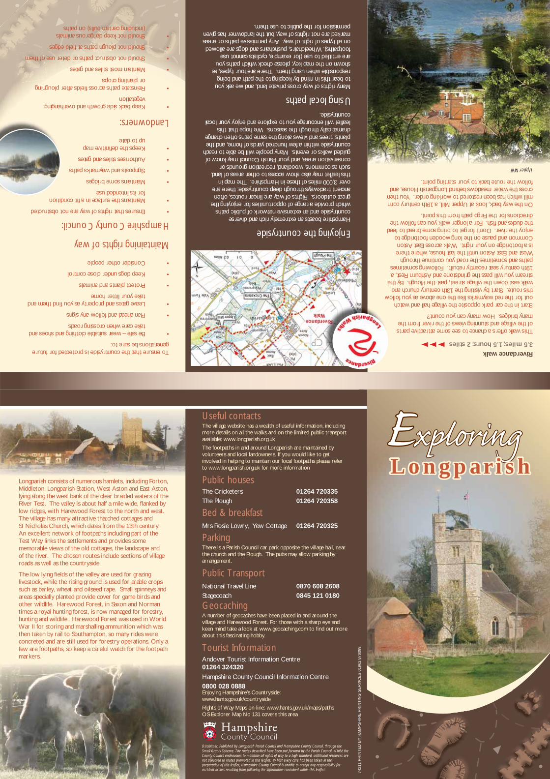
Riverdance walk
3.5 miles; 1.5 hours; 2 stiles
This walk offers a chance to see some attractive parts of the village and stunning views of the river from the many bridges. How many can you count?
Start in the car park opposite the village hall and watch out for the red waymarks like the one above as you follow this route. Start by visiting the 13th century church and walk east down the village street, past the Plough. By the stream you will pass the grindstone and Ashburn Rest, a 19th century seat recently rebuilt. Following sometimes paths and sometimes the road you continue through West and East Aston until the last house, where there is a footbridge on your right. Walk across East Aston Common and pause on the long wooden footbridge to enjoy the river. Don’t forget to bring some bread to feed the ducks and fi sh. For a longer walk you can follow the directions for the Firgo path from this point.
On the way back, look at Upper Mill, a 19th century corn mill which has been restored to working order. You then cross the water meadows behind Longparish House, and follow the route back to your starting point.
Upper Mill
Longparish consists of numerous hamlets, including Forton, Middleton, Longparish Station, West Aston and East Aston, lying along the west bank of the clear braided waters of the River Test. The valley is about half a mile wide, fl anked by low ridges, with Harewood Forest to the north and west. The village has many attractive thatched cottages and St Nicholas Church, which dates from the 13th century. An excellent network of footpaths including part of the Test Way links the settlements and provides some memorable views of the old cottages, the landscape and of the river. The chosen routes include sections of village roads as well as the countryside.
The low lying fi elds of the valley are used for grazing livestock, while the rising ground is used for arable crops such as barley, wheat and oilseed rape. Small spinneys and areas specially planted provide cover for game birds and other wildlife. Harewood Forest, in Saxon and Norman times a royal hunting forest, is now managed for forestry, hunting and wildlife. Harewood Forest was used in World War II for storing and marshalling ammunition which was then taken by rail to Southampton, so many rides were concreted and are still used for forestry operations. Only a few are footpaths, so keep a careful watch for the footpath markers.
EExploringxploring L ongparishL ongparish
Useful contactsThe village website has a wealth of useful information, including more details on all the walks and on the limited public transport available: www.longparish.org.uk
The footpaths in and around Longparish are maintained by volunteers and local landowners. If you would like to get involved in helping to maintain our local footpaths please refer to www.longparish.org.uk for more information
Public housesThe Cricketers 01264 720335
The Plough 01264 720358
Bed & breakfastMrs Rosie Lowry, Yew Cottage 01264 720325
ParkingThere is a Parish Council car park opposite the village hall, near the church and the Plough. The pubs may allow parking by arrangement.
Public TransportNational Travel Line 0870 608 2608
Stagecoach 0845 121 0180
GeocachingA number of geocaches have been placed in and around the village and Harewood Forest. For those with a sharp eye and keen mind take a look at www.geocaching.com to fi nd out more about this fascinating hobby.
Tourist InformationAndover Tourist Information Centre 01264 324320
Hampshire County Council Information Centre
0800 028 0888Enjoying Hampshire’s Countryside: www.hants.gov.uk/countryside
Rights of Way Maps on-line: www.hants.gov.uk/maps/pathsOS Explorer Map No 131 covers this area
Disclaimer: Published by Longparish Parish Council and Hampshire County Council, through the Small Grants Scheme. The routes described have been put forward by the Parish Council. Whilst the County Council endeavours to maintain all rights of way to a high standard, additional resources are not allocated to routes promoted in this leafl et. Whilst every care has been taken in the preparation of this leafl et, Hampshire County Council is unable to accept any responsibility for accident or loss resulting from following the information contained within this leafl et. 74
211
PR
INT
ED
BY
HA
MP
SH
IRE
PR
INT
ING
SE
RV
ICE
S 0
1962
870
099
To ensure that the countryside is protected for future generations be sure to:
• Be safe – wear suitable clothing and shoes and take care when crossing roads
• Plan ahead and follow any signs
• Leave gates and property as you fi nd them and take your litter home
• Protect plants and animals
• Keep dogs under close control
• Consider other people
Maintaining rights of way
Hampshire County Council:
• Ensures that rights of way are not obstructed
• Maintains the surface in a fi t condition for its intended use
• Maintains some bridges
• Signposts and waymarks paths
• Authorises stiles and gates
• Keeps the defi nitive map up to date
Landowners:
• Keep back side growth and overhanging vegetation
• Reinstate paths across fi elds after ploughing or planting crops
• Maintain most stiles and gates
• Should not obstruct paths or deter use of them
• Should not plough paths at fi eld edges
• Should not keep dangerous animals (including certain bulls) on paths
Enjoying the countryside
Hampshire boasts an extremely rich and diverse countryside and an extensive network of public paths which provide a range of opportunities for enjoying the great outdoors. Rights of way are linear routes, often ancient trackways through deep countryside; there are over 3,000 miles of these in Hampshire. The map in this leafl et may also show access to other areas of land, such as commons, woodland, recreation grounds or conservation areas, and your Parish Council may know of guided walks or events. Many people will be able to reach countryside within a few hundred yards of home, and the plants, trees and views along the same paths often change dramatically through the seasons. We hope that this leafl et will encourage you to explore and enjoy your local countryside.
Using local paths
Many rights of way cross private land, and we ask you to bear this in mind by keeping to the path and being responsible when using them. There are four types, as shown on the map key; please check which paths you are entitled to use (for example, cyclists cannot use footpaths). Wheelchairs, pushchairs and dogs are allowed on all types of right of way. Any permissive paths or areas marked are not rights of way, but the landowner has given permission for the public to use them.
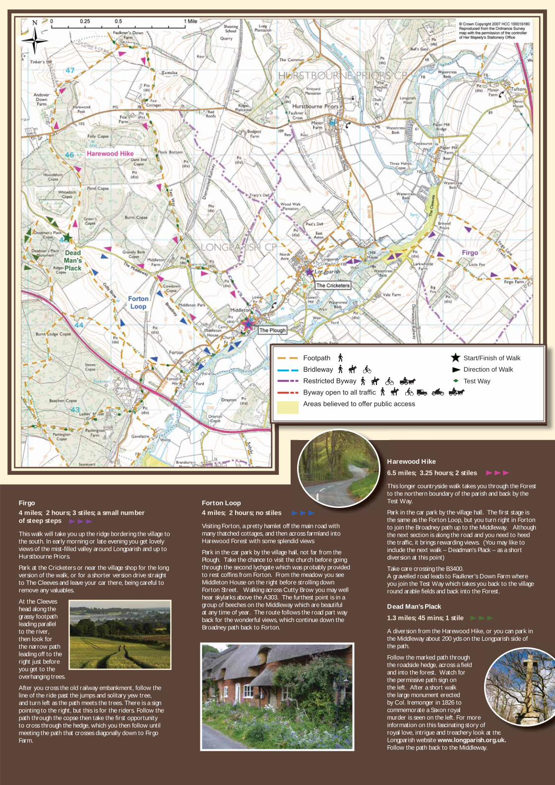
Footpath
Bridleway
Footpath
Bridlewayy
Footpath
Bridleway
Restricted Byway
Byway open to all traffic
Areas believed to offer public access
Start/Finish of Walk
Direction of Walk
Test Way
Firgo
4 miles; 2 hours; 3 stiles; a small number of steep steps
This walk will take you up the ridge bordering the village to the south. In early morning or late evening you get lovely views of the mist-fi lled valley around Longparish and up to Hurstbourne Priors.
Park at the Cricketers or near the village shop for the long version of the walk, or for a shorter version drive straight to The Cleeves and leave your car there, being careful to remove any valuables.
At the Cleeves head along the grassy footpath leading parallel to the river, then look for the narrow path leading off to the right just before you get to the overhanging trees.
After you cross the old railway embankment, follow the line of the ride past the jumps and solitary yew tree, and turn left as the path meets the trees. There is a sign pointing to the right, but this is for the riders. Follow the path through the copse then take the fi rst opportunity to cross through the hedge, which you then follow until meeting the path that crosses diagonally down to Firgo Farm.
Forton Loop
4 miles; 2 hours; no stiles
Visiting Forton, a pretty hamlet off the main road with many thatched cottages, and then across farmland into Harewood Forest with some splendid views
Park in the car park by the village hall, not far from the Plough. Take the chance to visit the church before going through the second lychgate which was probably provided to rest coffi ns from Forton. From the meadow you see Middleton House on the right before strolling down Forton Street. Walking across Cutty Brow you may well hear skylarks above the A303. The furthest point is in a group of beeches on the Middleway which are beautiful at any time of year. The route follows the road part way back for the wonderful views, which continue down the Broadney path back to Forton.
Harewood Hike
6.5 miles; 3.25 hours; 2 stiles
This longer countryside walk takes you through the Forest to the northern boundary of the parish and back by the Test Way.
Park in the car park by the village hall. The fi rst stage is the same as the Forton Loop, but you turn right in Forton to join the Broadney path up to the Middleway. Although the next section is along the road and you need to heed the traffi c, it brings rewarding views. (You may like to include the next walk – Deadman’s Plack – as a short diversion at this point)
Take care crossing the B3400. A gravelled road leads to Faulkner’s Down Farm where you join the Test Way which takes you back to the village round arable fi elds and back into the Forest.
Dead Man’s Plack
1.3 miles; 45 mins; 1 stile
A diversion from the Harewood Hike, or you can park in the Middleway about 200 yds on the Longparish side of the path.
Follow the marked path through the roadside hedge, across a fi eld and into the forest. Watch for the permissive path sign on the left. After a short walk the large monument erected by Col. Iremonger in 1826 to commemorate a Saxon royal murder is seen on the left. For more information on this fascinating story of royal love, intrigue and treachery look at the Longparish website www.longparish.org.uk. Follow the path back to the Middleway.
at the
H
666
TtT
P


![[Alvin b. stiles]_catalyst_manufacture_(chemical_i](https://img.dokumen.tips/doc/110x75/58e546171a28ab3a468b52a1/alvin-b-stilescatalystmanufacturechemicali.jpg)