Embed Size (px)
Citation preview
Maarten Plieger
Nils de Reus
Maarten Plieger
Nils de Reus
http://adaguc.knmi.nl/
This project is sponsored bySpace for Geo-Information
www.rgi.nl
Extending GDAL/OGR andExtending GDAL/OGR and
UMN UMN MapServerMapServer
Providing the building blocks for a Providing the building blocks for a
geospatial infrastructuregeospatial infrastructure
http://adaguc.knmi.nl
ADAGUC Workshop 2008
IntroductionIntroduction
• Overview on the datasets
• UMN MapServer and GDAL / OGR
• Extending the GDAL driver
• Extending the OGR driver
• Patching UMN MapServer
• ADAGUC Web Portal
• Overview on the datasets
• UMN MapServer and GDAL / OGR
• Extending the GDAL driver
• Extending the OGR driver
• Patching UMN MapServer
• ADAGUC Web Portal
This project is sponsored bySpace for Geo-Information
www.rgi.nlhttp://adaguc.knmi.nl/
http://adaguc.knmi.nl
ADAGUC Workshop 2008
DatasetsDatasets
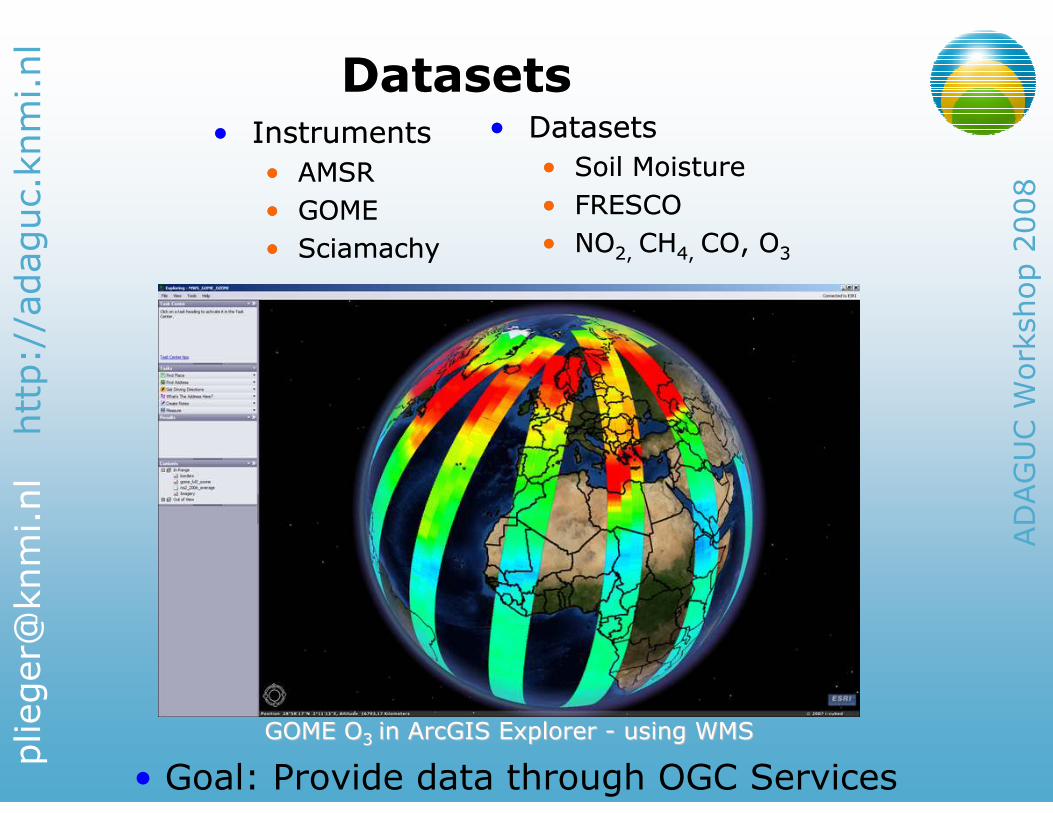
GOME OGOME O3 3 in ArcGIS Explorer in ArcGIS Explorer -- using WMSusing WMS
• Datasets
• Soil Moisture
• FRESCO
• NO2, CH4, CO, O3
• Datasets
• Soil Moisture
• FRESCO
• NO2, CH4, CO, O3
• Goal: Provide data through OGC Services
• Instruments
• AMSR
• GOME
• Sciamachy
• Instruments
• AMSR
• GOME
• Sciamachy
http://adaguc.knmi.nl
ADAGUC Workshop 2008
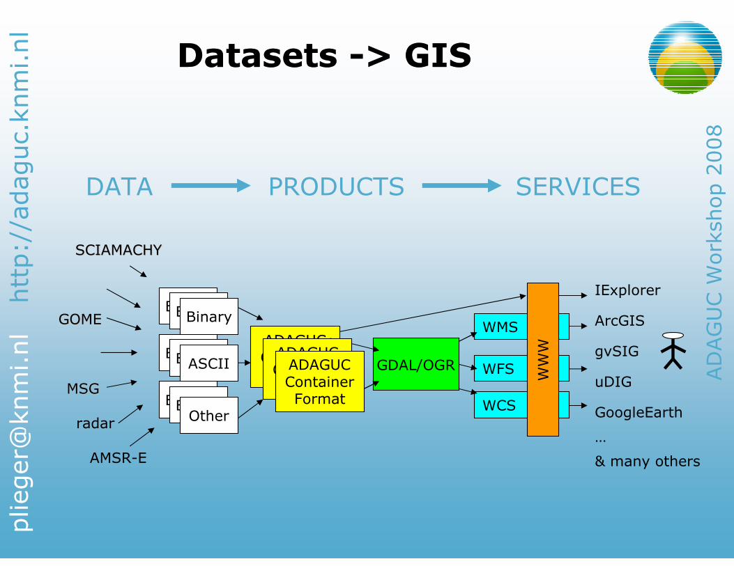
Datasets -> GISDatasets -> GIS
DATA PRODUCTS SERVICES
BinaryBinaryBinary
BinaryBinary
BinaryBinaryOther
WMS
WCS
WFS
ADAGUCContainerFormat
SCIAMACHYSCIAMACHY
radar
GOMEGOME
MSGMSG
GDAL/OGRADAGUCContainerFormat
ADAGUCContainerFormat
ASCII
ArcGIS
WWW
uDIG
gvSIG
GoogleEarth
…
& many others
IExplorer
AMSR-E
http://adaguc.knmi.nl
ADAGUC Workshop 2008
UMN MapServer and GDAL/OGRUMN MapServer and GDAL/OGR
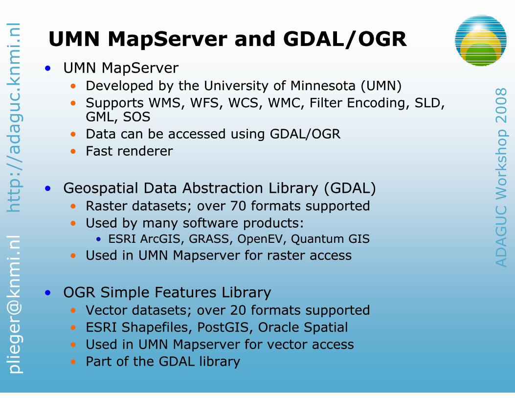
• UMN MapServer
• Developed by the University of Minnesota (UMN)
• Supports WMS, WFS, WCS, WMC, Filter Encoding, SLD, GML, SOS
• Data can be accessed using GDAL/OGR
• Fast renderer
• Geospatial Data Abstraction Library (GDAL)
• Raster datasets; over 70 formats supported
• Used by many software products:• ESRI ArcGIS, GRASS, OpenEV, Quantum GIS
• Used in UMN Mapserver for raster access
• OGR Simple Features Library
• Vector datasets; over 20 formats supported
• ESRI Shapefiles, PostGIS, Oracle Spatial
• Used in UMN Mapserver for vector access
• Part of the GDAL library
http://adaguc.knmi.nl
ADAGUC Workshop 2008
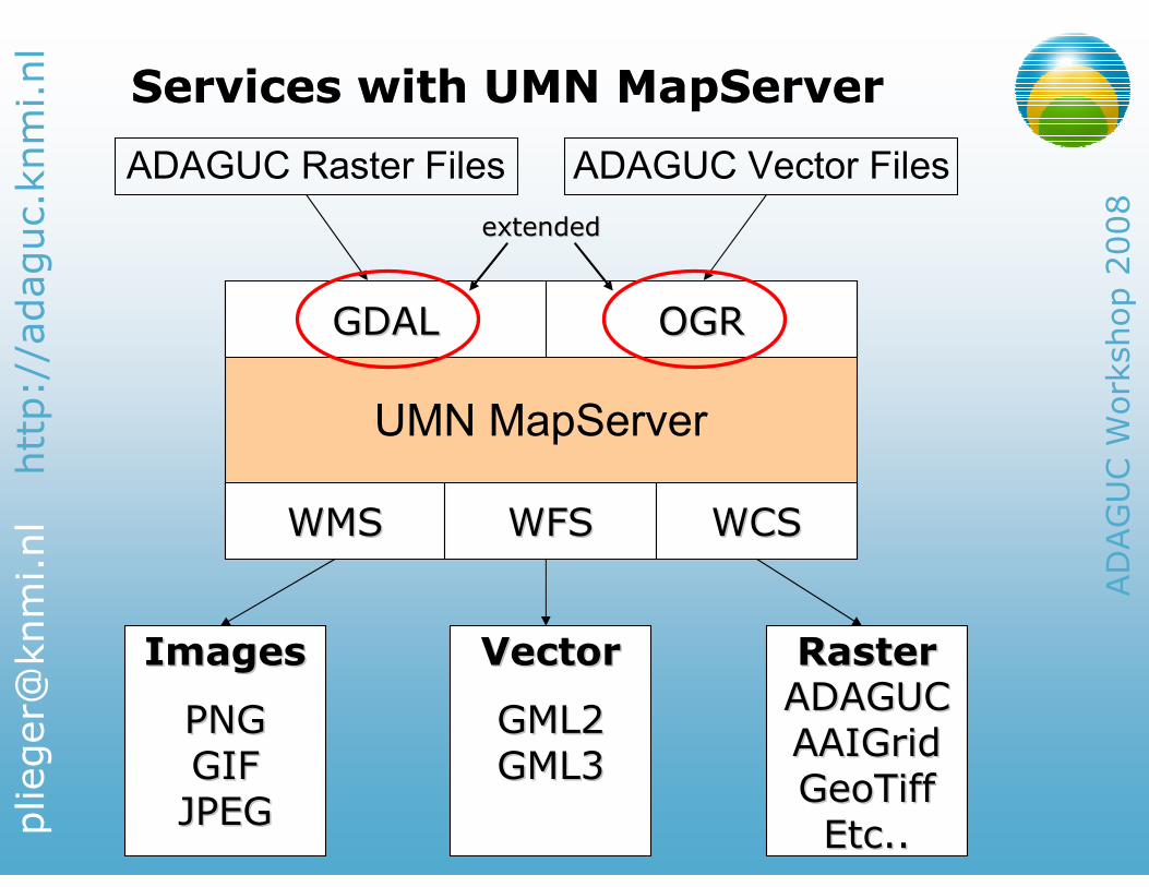
Services with UMN MapServerServices with UMN MapServer
UMN MapServer
ADAGUC Raster Files ADAGUC Vector Files
WMSWMS WFSWFS WCSWCS
GDALGDAL OGROGR
PNGPNG
GIFGIF
JPEGJPEG
GML2GML2
GML3GML3
ADAGUCADAGUC
AAIGridAAIGrid
GeoTiffGeoTiff
Etc..Etc..
ImagesImages VectorVector RasterRaster
extendedextended
http://adaguc.knmi.nl
ADAGUC Workshop 2008
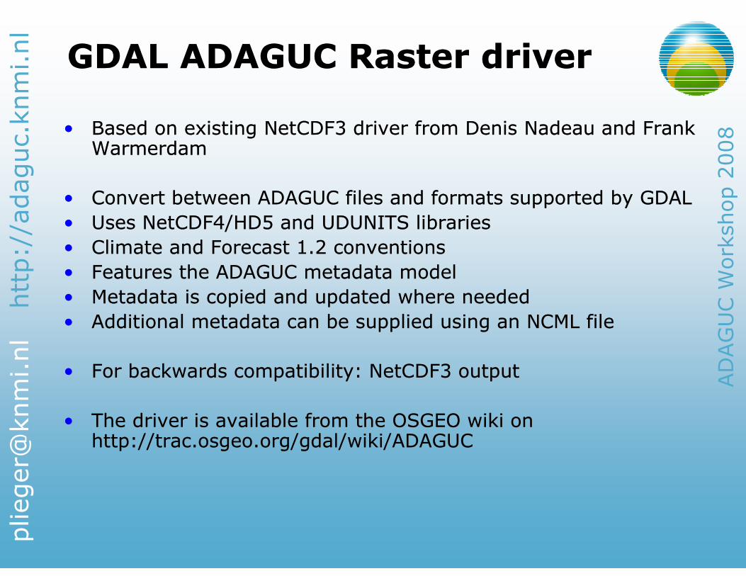
GDAL ADAGUC Raster driverGDAL ADAGUC Raster driver
• Based on existing NetCDF3 driver from Denis Nadeau and Frank Warmerdam
• Convert between ADAGUC files and formats supported by GDAL
• Uses NetCDF4/HD5 and UDUNITS libraries
• Climate and Forecast 1.2 conventions
• Features the ADAGUC metadata model
• Metadata is copied and updated where needed
• Additional metadata can be supplied using an NCML file
• For backwards compatibility: NetCDF3 output
• The driver is available from the OSGEO wiki on http://trac.osgeo.org/gdal/wiki/ADAGUC
http://adaguc.knmi.nl
ADAGUC Workshop 2008
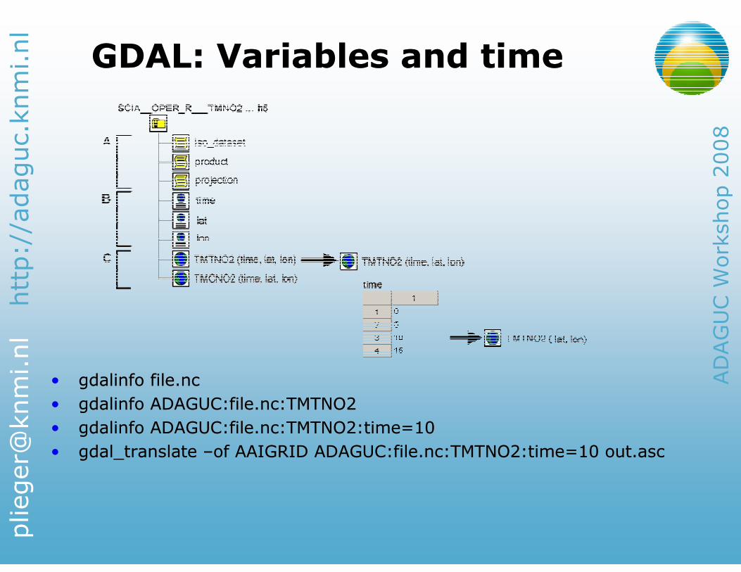
• gdalinfo file.nc
• gdalinfo ADAGUC:file.nc:TMTNO2
• gdalinfo ADAGUC:file.nc:TMTNO2:time=10
• gdal_translate –of AAIGRID ADAGUC:file.nc:TMTNO2:time=10 out.asc
• gdalinfo file.nc
• gdalinfo ADAGUC:file.nc:TMTNO2
• gdalinfo ADAGUC:file.nc:TMTNO2:time=10
• gdal_translate –of AAIGRID ADAGUC:file.nc:TMTNO2:time=10 out.asc
GDAL: Variables and timeGDAL: Variables and time
http://adaguc.knmi.nl
ADAGUC Workshop 2008
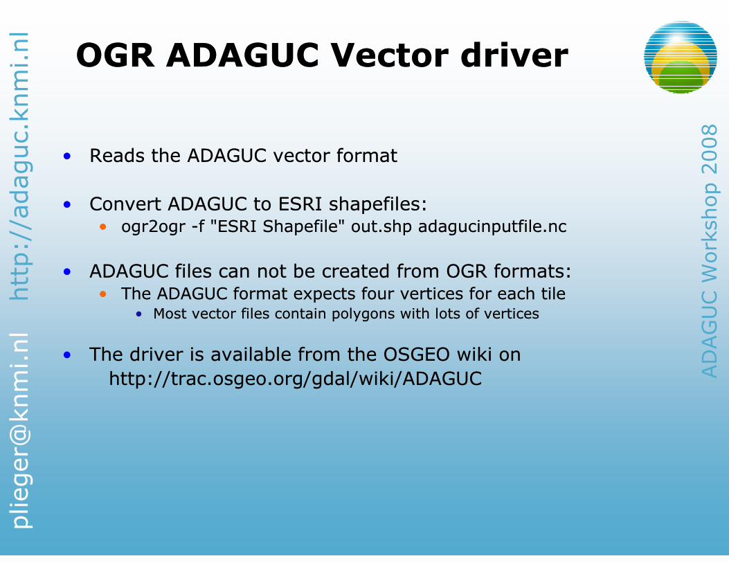
OGR ADAGUC Vector driverOGR ADAGUC Vector driver
• Reads the ADAGUC vector format
• Convert ADAGUC to ESRI shapefiles:• ogr2ogr -f "ESRI Shapefile" out.shp adagucinputfile.nc
• ADAGUC files can not be created from OGR formats:• The ADAGUC format expects four vertices for each tile
• Most vector files contain polygons with lots of vertices
• The driver is available from the OSGEO wiki on
http://trac.osgeo.org/gdal/wiki/ADAGUC
http://adaguc.knmi.nl
ADAGUC Workshop 2008
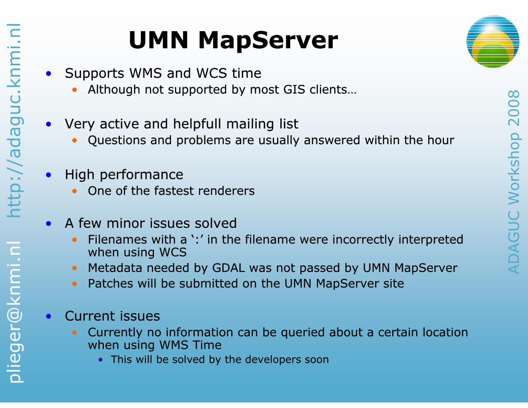
UMN MapServerUMN MapServer
• Supports WMS and WCS time• Although not supported by most GIS clients…
• Very active and helpfull mailing list• Questions and problems are usually answered within the hour
• High performance• One of the fastest renderers
• A few minor issues solved• Filenames with a ‘:’ in the filename were incorrectly interpreted when using WCS
• Metadata needed by GDAL was not passed by UMN MapServer
• Patches will be submitted on the UMN MapServer site
• Current issues• Currently no information can be queried about a certain locationwhen using WMS Time• This will be solved by the developers soon
http://adaguc.knmi.nl
ADAGUC Workshop 2008
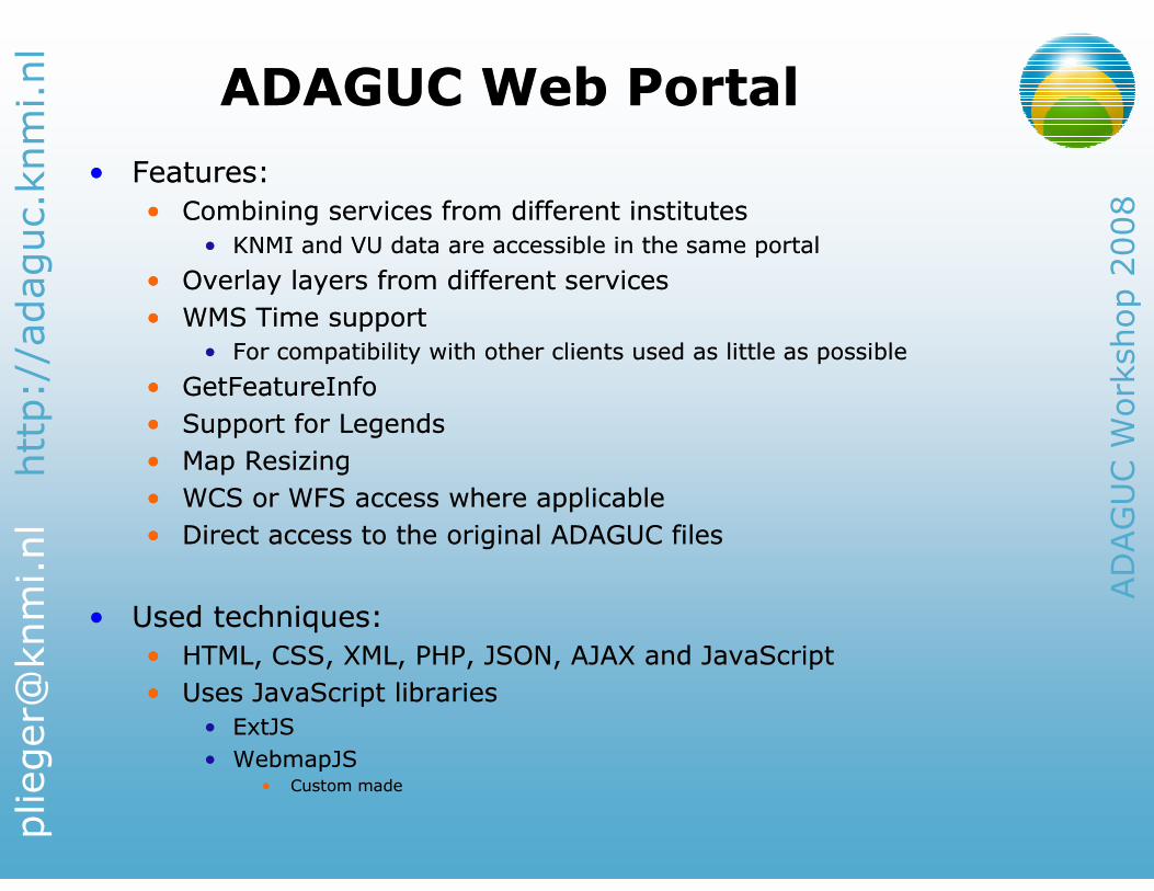
ADAGUC Web PortalADAGUC Web Portal
• Features:
• Combining services from different institutes
• KNMI and VU data are accessible in the same portal
• Overlay layers from different services
• WMS Time support
• For compatibility with other clients used as little as possible
• GetFeatureInfo
• Support for Legends
• Map Resizing
• WCS or WFS access where applicable
• Direct access to the original ADAGUC files
• Used techniques:
• HTML, CSS, XML, PHP, JSON, AJAX and JavaScript
• Uses JavaScript libraries
• ExtJS
• WebmapJS• Custom made
http://adaguc.knmi.nl
ADAGUC Workshop 2008
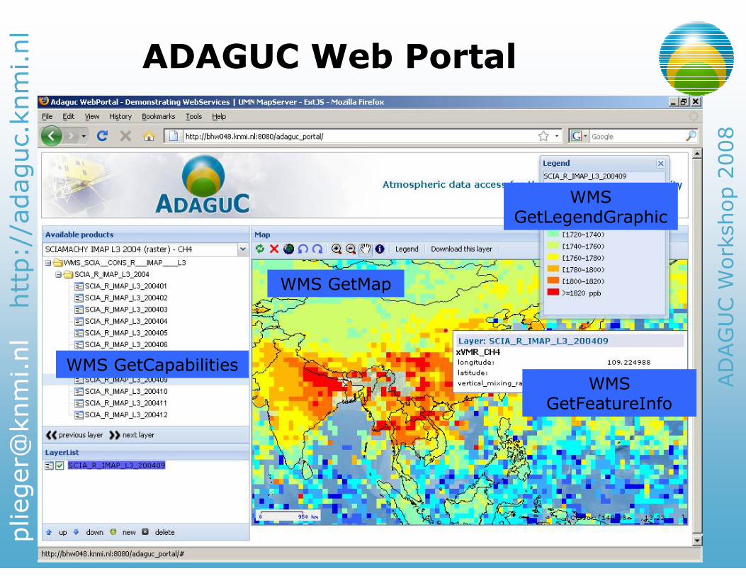
ADAGUC Web PortalADAGUC Web Portal
WMS GetCapabilities
WMS GetMap
WMS GetFeatureInfo
WMS GetLegendGraphic
http://adaguc.knmi.nl
ADAGUC Workshop 2008
Download data from the PortalDownload data from the Portal
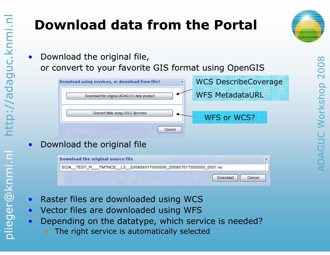
• Download the original file,
or convert to your favorite GIS format using OpenGIS
• Download the original file
• Raster files are downloaded using WCS
• Vector files are downloaded using WFS
• Depending on the datatype, which service is needed?• The right service is automatically selected
• Download the original file,
or convert to your favorite GIS format using OpenGIS
• Download the original file
• Raster files are downloaded using WCS
• Vector files are downloaded using WFS
• Depending on the datatype, which service is needed?• The right service is automatically selected
WCS DescribeCoverage
WFS MetadataURL
WFS or WCS?
http://adaguc.knmi.nl
ADAGUC Workshop 2008
WFS ServiceWFS Service
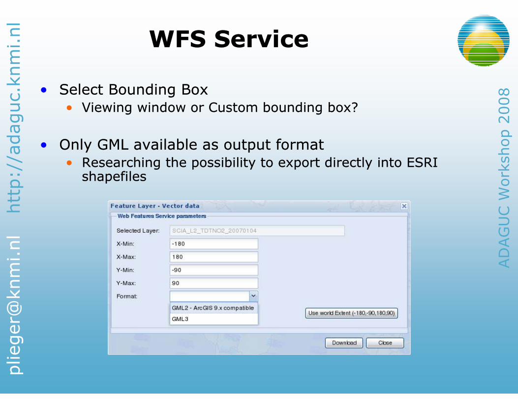
• Select Bounding Box
• Viewing window or Custom bounding box?
• Only GML available as output format
• Researching the possibility to export directly into ESRI shapefiles
• Select Bounding Box
• Viewing window or Custom bounding box?
• Only GML available as output format
• Researching the possibility to export directly into ESRI shapefiles
http://adaguc.knmi.nl
ADAGUC Workshop 2008
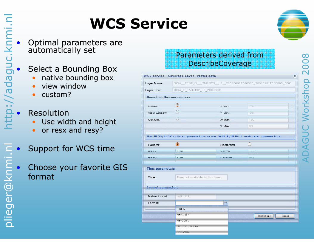
WCS ServiceWCS Service• Optimal parameters are automatically set
• Select a Bounding Box• native bounding box• view window• custom?
• Resolution• Use width and height • or resx and resy?
• Support for WCS time
• Choose your favorite GISformat
• Optimal parameters are automatically set
• Select a Bounding Box• native bounding box• view window• custom?
• Resolution• Use width and height • or resx and resy?
• Support for WCS time
• Choose your favorite GISformat
Parameters derived from DescribeCoverage
http://adaguc.knmi.nl
ADAGUC Workshop 2008
Open IssuesOpen Issues
• GDAL ADAGUC driver
• Supports currently only the dimensions lat, lon and time
• Support for other dimensions like ‘height’ can be added
• OGR ADAGUC driver
• Reads the whole source NetCDF file in to memory
• Should only read the parts that are needed…
• UMN MapServer
• WMS GetFeatureInfo does not yet return data when querying on time layers
• Support for x and y (2D) data is easy
• Support for x, y, time and height is tricky
• Not many GIS clients out there that support WMS time
http://adaguc.knmi.nl
ADAGUC Workshop 2008
• ADAGUC NetCDF4 used with GDAL/OGR and UMN MapServer
• Web Portal communicates with the server using purely OpenGIS services
• Third parties can setup their own services using the building blocks created within the ADAGUC project
• The demonstrated atmospheric datasets are now very well accessible to GIS users!
SummarySummary