Embed Size (px)
Citation preview

Experience Sharing Tour and Workshop on Shelterbelts and Fuel Wood Substitutes in Sudan
By Prof. Hassan A. Musnad and Dr. Nawal Khidir Nasr
December 2004
DCG Proceedings No. 14


Experience Sharing Tour and Workshop on Shelterbelts and Fuel Wood Substitutes in Sudan
Prof. Hassan A. Musnad Dr. Nawal Khidir Nasr
DCG Proceedings No. 14 December 2004

The Drylands Coordination Group (DCG) is an NGO-driven forum for exchange of practical experiences and knowledge on food security and natural resource management in the drylands of Africa. DCG facilitates this exchange of experiences between NGOs and research and policy-making institutions. The DCG activities, which are carried out by DCG members in Ethiopia, Eritrea, Mali and Sudan, aim to contribute to improved food security of vulnerable households and sustainable natural resource management in the drylands of Africa. The founding DCG members consist of ADRA Norway, CARE Norway, Norwegian Church Aid, Norwegian People's Aid, The Strømme Foundation and The Development Fund. Noragric, the Centre for International Environment and Development Studies at the Agricultural University of Norway, provides the secretariat as a facilitating and implementing body for the DCG. The DCG’s activities are funded by NORAD (the Norwegian Agency for Development Cooperation). Extracts from this publication may only be reproduced after prior consultation with the DCG secretariat. The findings, interpretations and conclusions expressed in this publication are entirely those of the author(s) and cannot be attributed directly to the Drylands Coordination Group.
© H.A. Musnad and N. K. Nasr, Drylands Coordination Group Proceedings No. 14 (12, 2004) Drylands Coordination Group c/o Noragric P.O. Box 5003 N-1432 Ås Norway Tel.: +47 64 96 53 30 Fax: +47 64 94 07 60 Internet: http://www.drylands-group.org ISSN: 1502-248X Photo credits: T.A. Benjaminsen, Gry Synnevåg. Cover design: Spekter Reklamebyrå as, Ås. Printed at: Rotator, Ås.

iii
Table of Contents
Acknowledgements............................................................................................................................vi
Acronyms ..........................................................................................................................................vii
The Drylands Coordination Group.............................................................................................. viii
1. INTRODUCTION .......................................................................................................1
1.2 Objectives......................................................................................................................................1 1.2.1 General objective ....................................................................................................................1 1.2.2 Specific Objectives .................................................................................................................2
1.3 Scope of the Study........................................................................................................................2
2. THE PHYSICAL ENVIRONMENT OF THE STUDY AREA………………. 3
2.1 Location.........................................................................................................................................3
2.2 Climate ..........................................................................................................................................3
2.3 Natural Resources ........................................................................................................................3
3. BACKGROUND ..........................................................................................................4
3.1 Wind and Moving Sand...............................................................................................................4
3.2 Techniques and Measures to Control moving sand..................................................................5 3.2.1 Drifting sand ...........................................................................................................................5 3.2.2 Sand dune................................................................................................................................6
3.3 Shelterbelts and Drifting Sand....................................................................................................6
4. TOUR FINDINGS AND SUGGESTION ................................................................1
4.1 Sites Visited.................................................................................................................................11 4.1.1 Um Jawaseer .........................................................................................................................11 4.1.2 El Sherian Plantations and Nursery ......................................................................................11 4.1.3 El Debba................................................................................................................................11 4.1.4 El Debba Site on the E. Bank................................................................................................11 4.1.5 El Getaina and Neaeima........................................................................................................12 4.1.6 West of the White Nile..........................................................................................................12 4.1.7 N. Kordofan Sites..................................................................................................................12 4.1.8 The Area Round Bara ...........................................................................................................12 4.1.9 El Semeih Site.......................................................................................................................13 4.1.10 Kassala ................................................................................................................................13 4.1.11 Port Sudan ...........................................................................................................................13 4.1.12 Tokar ...................................................................................................................................13 4.1.13 Port Sudan – Sawakin – Haya – Atbara – El Damer ..........................................................13 4.1.14 El Damer .............................................................................................................................13

iv
4.1.15 El Hudaiba Research Station...............................................................................................14 4.1.16 El Aleib Shelterbelt.............................................................................................................14 4.1.17 Shendi..................................................................................................................................14 4.1.18 El Dewemat/Gandatu Shelterbelt........................................................................................14
4.2 Establishment of irrigated Shelterbelts at El Hudi east Atbra..............................................16
4.3 Papers Presented at the Workshop ..........................................................................................16
4.4 Group discussion and Recommendations................................................................................17 4.4.1 Introduction...........................................................................................................................17 4.4.2 Group One: Shelterbelt design..............................................................................................17 4.4.3 Group two: suitable species for shelterbelts .........................................................................17 4.4.4 Group three: alternative fuel wood .......................................................................................18 4.4.5 Group four: establishment and irrigation of shelterbelts ......................................................18
5. RECOMMENDATIONS..........................................................................................20
5.1 Specific recommendations for Um Jawasir .............................................................................20
5.2 General Recommendations for Drylands ................................................................................20
6. GUIDELINES FOR UM JAWASIR ......................................................................21
6.1 Suggested Techniques and Design............................................................................................21
6.2 Fuel wood alternatives ...............................................................................................................21
6.3 Suggested Research and Measurements ..................................................................................23
7. REFERENCES .........................................................................................................24
8. APPENDICES ............................................................................................................26
8.1 Further Literature to be examined...........................................................................................26
8.2 Programme .................................................................................................................................27
8.3 List of Participants.....................................................................................................................28
8.4 Sudan maps.................................................................................................................................29

v
List of tables and figures Table 1: Sites visited in the Northern states of Sudan suffering from drifting sand………………..14
Figure 1: Aggregates on an eroded surface with sand deposition, in micro-relief and very
efficiently over large distance leeward of small isolated Panicum turgidum grass, with a beneficial
biomass distribution………………………………………………………………………………….8
Figure 2: Wind measurements leeward of an Acacia tortilis tree with trapped sand all around,
depositions due to soil surface irregularities and Leptadenia pyrotechnica with settled sand in the
background…………………………………………………………………………………………...9
Figure 3: Leptadenia pyrotechnica with settled sand………………………………………………...9
Figure 4: Prosopis juliflora with settled sand……………………………………………………….10
Figure 5: Suggested shelterbelt design…………………………………………………………….. 21
Figure 6: Suggested U shape shelterbelt……………………………………………………………21
Figure 7: Map of the Republic of the Sudan and the sites visited…………………………………..28
Figure 8: Mean annual rainfall...........................................................................................................30
Figure 9: Soil regions of Sudan..........................................................................................................31
Figure 10: Vegetation cover in Sudan................................................................................................32

vi
ACKNOWLEDGEMENTS I would like to thank the dean of the faculty of forestry and range Dr.Abd Elhafeez Ali from the university of science and technology, who participated in the workshop. My sincere thanks are also extended to the director of FNC and his deputy Mr. Ali Korak who participated in the workshop and gave permission to his staff to attend the workshop at Um Jawaseer. Our thanks also go to the director of the forestry research centre for his useful contribution at the workshop. The director of Um Jawaseer and his staff at Um Jawaseer deserve a lot of thanks for the good arrangement during our stay at Um Jawaseer. The director of ADRA Sudan honoured the workshop by attending the first session, welcoming participants and opening the workshop.

vii
ACRONYMS ADRA Adventist Development and Relief Agency F.A.O Food and Agriculture Organization of the United Nations F.N.C Forestry National Corporation F.R.C Forestry Research Centre N.C.R National Centre for Research N.G.O Non- Governmental Organization RAB Part of F.A.O Regional Group SSE Sudan Sahel Ethiopia Programme SUST Sudan University of Science and Technology TTMI Traditional Techniques for Microclimate Improvement (a Dutch project in
Sudan 1989-2001)

viii
THE DRYLANDS COORDINATION GROUP DCG was created after the dissolving of the Sudan Sahel Ethiopia Programme (SSE), which was established by the Norwegian Ministry of Foreign Affairs in response to the catastrophic drought in the Sahel region in 1984-1985. The main objectives of the former SSE programme were food security and environmental rehabilitation. The Drylands Coordination Group (DCG) – which formed later – is an NGO-driven forum for exchange of practical experience and knowledge on food security and natural resource management in the drylands of Africa. The role of DCG is to facilitate the exchange of experiences between NGOs and research, education, and policy-making institutions. DCG activities, which are carried out by DCG members in Ethiopia, Eritrea, Mali and Sudan, aim to contribute to improved food security of the vulnerable households and sustainable natural resource management of the drylands of Africa. DCG Sudan became an independent member in March 2004 after splitting from DCG Ethiopia Sudan, which was formed in April 2000. DCG Sudan was established in Nairobi Kenya from the Norwegian funded NGOs operating in the greater Sudan: ADRA based in Northern Sudan, ADRA based in South Sudan, CARE based in Northern Sudan, NCA based in Northern Sudan, NCA based in Southern Sudan, and NPA based in Southern Sudan.
Experience Sharing Tour and Workshop on Shelterbelts and Fuel Wood Substitutes
1
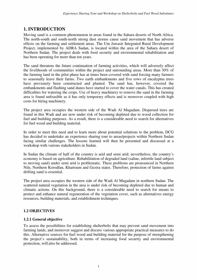
1. INTRODUCTION Moving sand is a common phenomenon in areas found in the Sahara deserts of North Africa. The north-south and south-north strong dust storms cause sand movement that has adverse effects on the farming and settlement areas. The Um Jawasir Integrated Rural Development Project, implemented by ADRA Sudan, is located within the area of the Sahara desert of Northern Sudan. The project deals with food security and environmental rehabilitation and has been operating for more than ten years. The sand threatens the future continuation of farming activities, which will adversely affect the livelihoods of communities within the project and surrounding areas. More than 30% of the farming land in the pilot phase has at times been covered with sand forcing many farmers to seasonally leave their farms. Two earth embankments and five rows of eucalyptus trees have previously been constructed and planted. The sand has, however, covered the embankments and flashing sand dunes have started to cover the water canals. This has created difficulties for watering the crops. Use of heavy machinery to remove the sand in the farming area is found unfeasible as it has only temporary effects and is moreover coupled with high costs for hiring machinery. The project area occupies the western side of the Wadi Al Mugadam. Dispersed trees are found in this Wadi and are now under risk of becoming depleted due to wood collection for fuel and building purposes. As a result, there is a considerable need to search for alternatives for fuel wood and building material. In order to meet this need and to learn more about potential solutions to the problem, DCG has decided to undertake an experience sharing tour to areas/projects within Northern Sudan facing similar challenges. The lessons learned will then be presented and discussed at a workshop with various stakeholders in Sudan. In Sudan the climate of half of the country is arid and semi arid; nevertheless, the country’s economy is based on agriculture. Rehabilitation of degraded land (saline, infertile land subject to moving sand) under semi arid is problematic. These problems are pronounced in Northern Nile, Northern Korodfan, Khartoum and Gezira states. Therefore, protection of farms against drifting sand is essential. The project area occupies the western side of the Wadi Al Mugadam in northern Sudan. The scattered natural vegetation in the area is under risk of becoming depleted due to human and climatic actions. On this background, there is a considerable need to search for means to protect and enhance natural regeneration of the vegetation cover, such as alternatives energy resources, building materials, and establishment techniques.
1.2 OBJECTIVES
1.2.1 General objective To assess the possibilities for establishing shelterbelts that may prevent sand movement into farming lands, and moreover suggest and discuss various appropriate practical measures to do this. Alternative sources for fuel wood and building material for the purpose of strengthening the project’s sustainability, both in terms of increasing food security and environmental protection, will also be addressed.

Drylands Coordination Group
2
1.2.2 Specific Objectives
• Identify appropriate biological and mechanical measures to arrest moving sand. Biologically:
- Identify multipurpose species of trees, shrubs or grasses that possess the following
characteristics: fast growing rate; physical potential to reduce wind velocity and fix sands; unpalatable to livestock and resistant to drought.
Mechanically:
- Identify mechanical measures that control or prevent sand movements.
- Recommend appropriate designs of using these techniques to mitigate the effect of drifting sand.
- Find feasible and acceptable recommendations for substitute/alternative fuel wood and other energy sources that could minimize the cutting and use of the planted trees.
• Hold a workshop to present and discuss recommendations with the project staff at Um Jawasir, as well as with other relevant stakeholders.
1.3 SCOPE OF THE STUDY Extensive literature review focuses on the mechanisms of drifting sand and their control worldwide while particular attention was paid to the Sudanese experiences. The latter were supported by an experience sharing tour to various states in North Sudan (Northern State, Kordofan, State, the Nile State and the Red Sea State) facing the problem in question and having the same climatic condition. The tour was aiming to reach consensus on:
• shelterbelt designs, species, establishment methods, watering, protection and management;
• all methods of sand dune fixation; • species for alternative energy, substitute renewable energy including solar, etc. and; • finally environmental protection and sustainable agriculture in the drylands of Sudan
and elsewhere.
A workshop was then held at the Um Jawasir site for discussion and recommendations.

Experience Sharing Tour and Workshop on Shelterbelts and Fuel Wood Substitutes
3
2. THE PHYSICAL ENVIRONMENT OF THE STUDY AREA The information in the following sections (2.1-2.3) is from an ADRA unpublished report.
2.1 LOCATION The Umjawasir project falls within the arid zone of Sudan. The area lies between latitude 16�
53 ⁄ N and 16 � 56 ⁄ N and longitude 31� 36� E and 31� 40� E. The project lies on the eastern side of Wadi Elmgadam.
2.2 CLIMATE Rainfall The dry lands of Sudan experience low and erratic rainfall. It is also mainly in the summer that the evaporation reduces the rain’s effectiveness (see figure 8, mean annual rainfall). Temperature Extreme high temperature during the summer at an average maximum of 39°C and a minimum of 21°C. During the winter the average is 29°C and 15°C for maximum and minimum temperature respectively. Wind Two main wind directions prevail in the area. The northeast (October- June) strong dry winds with sand storms result from the seasonal movement of the Inter Tropical convergence Zone. During July- September the dominant wind direction is the southern wind. However, wind directions sometimes interchange to west and east directions. Soil Figure 9 (Soil Regions of Sudan) depicts the soil of Sudan. Loamy clay soil with low nitrogen and organic matter with some patches of soil compaction and salinity is generally found in this area. The later increases with irrigation.
2.3 NATURAL RESOURCES Vegetation Cover The cover is scanty and dictated by high temperature and low rainfall. Acacia and ephemeral grasses dominate the cover see figure 10 (Vegetation of Sudan). Ground water table: The area is underlain by a rich underground Nubian sandstone aquifer that is fed and recharged from the river Nile and some seasonal stream. The estimated reservoir is 2x10¹¹ m3. The static water level recorded during 5 years of testing was between 27.6-27.7m. Livestock The recovery of the livestock after the drought of the 1980s tremendously improved the economic, social, and nutritional status of the tribes living in the area. Land use system Apart from the project’s irrigated areas, rain fed cultivation is practised during rainy seasons along and within Wdai El-Mggadam. Sorghum, watermelon, and cucumber are the main crops and vegetables being cultivated.

Drylands Coordination Group
4
3. BACKGROUND
3.1 WIND AND MOVING SAND Wind is an erosive agent, defined as the displacement of air relative to the surface (in a horizontal direction). The differences in atmospheric pressure, which are caused by variation in temperature distribution, are the main causes of wind (WMO, 1983). When it blows strong enough over an erodible surface, particles start to move further inducing soil degradation, erosion processes, particle transportation and deposition. Three modes of motion are recognized:
Saltation: A progression of particles by successive jumps. It is initiated by the direct wind pressure and sustains its motion by its impact with the surface. These ways of transportation depend on the grain size. The higher the particle rises, the larger the path flow and the greater the energy it can gain. The momentum gained is responsible for the continuation of sand movement, even when the shear velocity falls below the fluid threshold (Chepil, l958; Watson, 1989). Prolonged soil movement increases the saltation concentration (avalanching) (Chepil, 1963; Wilson and Cook, 1980; Wolfe and Nickling, 1993).
Creep: Transport affected through successive displacements. The creeping sand is initiated by the moving grains in saltation.
Suspension: Movement of particles carried by a mass of air; the size of the particles is so small that their fall due to gravity is very slow and air turbulence is enough to keep them in the air (Lyles, 1988).
The wind dislodges, transports and deposits particles. By doing so, the wind sorts the surface by selective and non-selective removal and deposition. As a result the surface features change into:
• residual soil material,
• lag sand
• loess
• sand dunes and clay dunes (Bagnold, 1954; Chepil, 1963; Wilson and Cook, 1980).
Two types of dunes can be recognized:
• Fixed dunes;
• Active dunes divided into three different families:
- Crescent dune family;
- Linear dune family;
- Star dune family (Mainguet ,1986).

Experience Sharing Tour and Workshop on Shelterbelts and Fuel Wood Substitutes
5
3.2 TECHNIQUES AND MEASURES TO CONTROL MOVING SAND
3.2.1 Drifting sand To overcome the problems created by hindering passing sand, four approaches have been employed: deposition of drifting sand upwind of the area subject to the sand invasion; enhancement of its transportation over the area under threat; reduction of the sand supply; deflection of the moving sand.
Deposition of drifting sand
The idea is to reduce the wind sand transportation capacity by:
• Ditches, which is a pit or trench upwind;
• a barrier and fence constructed upwind of the area to be protected. It produces an area of reduced sand carrying capacity ahead of and behind the area to be protected. The barrier efficiency depends on wind velocity and size, porosity and morphology of the barrier;
• a vegetation belt.
Enhance sand transportation over the area under threat
The principle is to increase the wind's sand moving capacity by increasing the wind velocity and to minimize sand deposition by reducing the surface ability to trap moving sand as follows:
• aerodynamic streamlining by shaping the surface or removing areas of reduced sand capacity,
• surface treatment with the objective of reducing the potential sand supply downwind.
Reduction of the sand supply
This approach is suitable for areas where intense sand movement occurs and the deposition of sand upwind behind a barrier is so great. The principle is to identify the main source and stabilize the deflating sand body by:
• surface treatment, which can be done by increasing the grain size on the surface; chemical treatment; application of a surface layer of oil or asphalt;
• binding the surface using natural material;
• fences and;
• vegetation cover.
Deflection of the moving sand
This can be done by using the same techniques mentioned earlier, such as barrier and tree belt not to deposit sand, but to deflect the sand stream. Tow types were exercised:
• fence slanted at 45 º to the direction of the drifting sand, and
• V-shaped barrier into the sand stream.

Drylands Coordination Group
6
3.2.2 Sand dune Moving dunes can be dealt with in three ways:
• removal of the dunes mechanically,
• dissipation of the dune by reshaping, trenching or surface stabilization techniques and,
• immobilization of the dunes by changing their aerodynamic form.
The choice depends on the type of the area to be protected, its distance from the dune and to some extent the size of the dune.
3.3 SHELTERBELTS AND DRIFTING SAND Lack of sufficient data on sand flux and variability of physical characteristics of the sand makes the assessment of the performance of many well-established techniques to halt moving sand in the field difficult (Watson, 1985). Important amongst the measures to combat manifestation of desertification in general are tree strips and/or shelterbelts. Shelter plantings in the world have been well researched, but little of the documented research on windbreaks relates to tropical areas (Nicholas, 1988). In a study by Van Eimern et al. (1964) on shelterbelts and windbreaks, only 8 of 1020 documents on the subject referred to tropical zones (Jensen in Nicholas, 1988).
A shelterbelt is defined as a strip of trees and/or shrubs planted to protect fields, homes, canals or other areas from wind and blowing soil or sand (Rocheleau et al., 1988). Windbreaks abstract the wind energy and hence decrease the wind drag on surfaces windward and leeward. The effectiveness of a barrier to reduce avalanching is determined by wind speed and duration, erodibility of the surface, and biomass distribution, shape, height and porosity of the barrier (Chepil and Woodruff, 1963; Lyles, 1988).
Wind erosion of soil can cause serious problems with new tree plantings, either by removing soil from around young trees, or by covering them with substantial drifts (Ritchie, 1988). The major role of shelterbelt planting is to protect agricultural land from soil movement. This movement may be either onto the farming areas in the form of drifting soils, where the windbreaks and dune-fixation plantings will assist in reducing this movement, or within and from the land being farmed, where soil loss reduces productivity and soil abrasion of crop plants may cause significant reductions in yield (Ritchie, 1988). For more theoretical and quantitative studies on wind and air movement near trees and shelterbelts and their consequences consult: Spaan and Stigter 1991; Mohammed et. al., 1996b; Stigter et.al., 1997; Mohammed et. al., 1999; Kainkwa and Stigter, 2000; Stigter et.al., 2000; Onyewotuet al., 2003b.
In Kuwait, mechanical and biological techniques were applied to control sand. Mechanical measures using (windbreak) fences, of corrugated metal plates of 1.5m and 2m high and constructed soil ridges (dykes) were applied. The effectiveness of the fences was determined by the local condition and soil surface roughness, while soil ridges were deflated by severe winds in open areas. In biological control, outer and inner tree belts with 1 to 2 rows in the outer belt were used and their efficiency was found to be controlled by their porosity, their

Experience Sharing Tour and Workshop on Shelterbelts and Fuel Wood Substitutes
7
height, the type of trees and their orientation. However, their assessment showed that they were ineffective and economically unfeasible (Al-Ajmi et al., 1995).
In Saudi Arabia, problems associated with moving dunes are less severe than with drifting sand and relatively few investigations have been done on the former (Kerr, Nigra 1952 and Finkle 1959, cited in Watson 1985). However, different procedures and technologies have been adopted for each case at individual locations.
In Sudan on-farm research has been done in Central Sudan through TTMI (Traditional Techniques for Microclimate Improvement- a comprehensive international research project on this subject). Their quantitative agro-meteorology of the protective eucalyptus shelterbelts recommended the following design aspects (Mohammed et al. 1995a; 1995b; 1996a; 1996b, 1999):
• Trenches as means of sand trap have to be dug during the early stages of shelterbelt establishment;
• The length of the belt has to be longer than the area to be protected;
• It has to be wide in depth to ensure long-term protection; between 25 to 30 m width in depth with staggered planting appears sufficient;
• To protect the belt itself from accumulation of sand and hence obtain a long life span, it has to be high and dense;
• Permeability of the belt is important since very dense belts may be damaged by wind and will create heavy turbulence in the lee-side field (Stigter et al. 1989);
• It has to be perpendicular to the prevailing wind, unless the situation indicates otherwise;
• Openings in the belt have to be avoided;
• Appropriate species have to be selected to tolerate drought, heat, local pests and diseases, illegal "grazing", deposition of sand and sand blasting;
• Species of long life span and of high growth rate are preferred for quick protection;
• A suitable combination of dense shrubs in front of tall strong trees should be found;
• Other benefits than protection are possible, such as byproducts (fuel wood, building poles and animal fodder) with the protective role of the belt remaining top priority.
In a desertified secondary source area of drifting sand encroaching on parts of the one million ha Gezira Irrigation Scheme in Central Sudan, a solution of sand settlement by trees was envisaged by the TTMI research project (Al-Amin 1999). The result showed that the scattered trees of the right densities modify and reduce wind effects. But selection of the species and their densities for different purposes should be supported by more to the point research, (Al-Amin et.al., 2004). The study on selection and establishment using both flood and drip irrigation with different interval and suitability of trees for use in depositing drifting sand had shown that the most successful species for sand settlement under windy conditions were:

Drylands Coordination Group
8
• Leptadenia pyrotechnica (Figure 3): It provides good protection and establishes well with medium irrigation and when protected from sand blasting at early establishment.
• Panicum turgidum (Figure 1): It is difficult to establish, but is extremely efficient in settling drifting sand when found in a cluster.
• Prosopis juliflora (Figure 4): It has reasonable establishment potential and good sand settling properties making it a good choice.
• Acacia totilis (Figure 2): It tolerates well hard conditions and is aerodynamically very successful on large scale when its biomass mass is kept low by grazing (Al-Amin, 1999; Al-Amin et. al 2003 and 2004).
Figure 1: Aggregates on an eroded surface with sand deposition, in micro-relief and very efficiently over large distance leeward of small isolated Panicum turgidum grass, with a beneficial biomass distribution. (Adapted from Al-Amin 1999)

Experience Sharing Tour and Workshop on Shelterbelts and Fuel Wood Substitutes
9
Figure 2: Wind measurements leeward of an Acacia tortilis tree with trapped sand all around, depositions due to soil surface irregularities and Leptadenia pyrotechnica with settled sand in the background. (Adapted from Al-Amin 1999)
Figure 3: Leptadenia pyrotechnica with settled sand. (Adapted from Al-Amin 1999)

Drylands Coordination Group
10
Figure 4: Prosopis juliflora with settled sand. (Adapted from Al-Amin 1999)

Experience Sharing Tour and Workshop on Shelterbelts and Fuel Wood Substitutes
11
4. TOUR FINDINGS AND SUGGESTION
4.1 SITES VISITED Most of the sites visited (see figure 7) are subjected to blowing sand either in form of saltating or /and moving dunes, but no real control measures have been searched or implemented in the sites (summary in table 1). The areas have a dry climate and two dominant wind directions that are north and northeast during wintertime and southwest during summer. The areas with an annual rainfall of less than 100 mm (Nile and Northern States, same climate conditions as Um Jawasir) have adequate ground water; the other states have an annual rainfall of not less than 200 mm.
4.1.1 Um Jawaseer This site suffers from sand drift. There is an urgent need for external and internal shelterbelts. The old external shelterbelt suffered from lack of watering and most of its trees died. Although it was supported by two earth embankments, it failed to offer continuous protection to the adjacent plots. It has been reported that failure resulted from inadequate watering of the eucalyptus trees. Furthermore, the choice of this species did not make the shelterbelt very efficient particularly at the bottom where eucalyptuses lack lower branches. As for internal belts, most of the farmers were not keen to establish them.
4.1.2 El Sherian Plantations and Nursery This organization was able to raise and maintain several tree species (Eucalypts, Albizzia, Neem, Date Palm, etc.); all the species inspected showed good growth. Trees are arranged in the form of plots and homestead shelters. The message forwarded by El Sherian is that in this locality trees can be established if well watered and protected. The site shows the same aridity as Um Jawaseer. The nursery is well designed and sheltered and it contains an adequate number of plantable seedlings.
4.1.3 El Debba The Western bank of the Nile suffers from gully erosion "Haddam" caused by changes in riverbed morphology due to sand pouring into the river causing several islands and pushing water to gully the western bank. Palm trees, pump sites and valuable land get lost as a result of this erosion. This is a continuous hazard that threatens people every year during the flood season. The farmers claim that the removal of rocks that used to exist upstream and the huge source of sand on the eastern bank are the main causes of "Haddam". The Eastern Bank opposite El Debba contains all sorts of dunes, sand sheets, barchans, and dune complexes.
4.1.4 El Debba Site on the E. Bank Several sites were visited and all forms of sand accumulation were seen: sand sheets, sand dune complexes and barchars. All these forms of sand are threatening fertile arable land, as well as the Nile itself. A commendable effort has been done to reduce sand movement (S. O. S. Sahel and FNC). Great extension efforts were also reported on community forestry in the area, but these useful efforts seem extremely meagre compared to the extent of the problem.

Drylands Coordination Group
12
Community participation was felt near the houses and fields, but external shelterbelts away from their holdings received little attention. The main species used was Misquite. When this plant was banned, efforts of sand dune fixation almost ceased awaiting the use of a substitute species. The following support is required for this site:
• Mapping the dune fields by remote sensing technique. • Designing of proper effective external shelterbelt matrix. • More funding, more human resources to implement an agreed plan of reducing sand
movement. • All techniques of sand dune fixation and relevant plants are to be utilized. • Watering and revegetation techniques are required.
4.1.5 El Getaina and Neaeima El Getaina and Neaeima suffer from sand drift; schools and hospitals have huge sand accumulations. External shelterbelts are required along with continuous removal; otherwise buildings have to be abandoned as in the case of Neaima elementary school and staff houses.
4.1.6 West of the White Nile The team held discussions with FNC and Range staff about sand encroachment problems in the area. A field visit was then made to Tayba where sand dunes were fixed by planting Marekh (Leptadenia pyrotechnica). Seedlings of this plant were raised in the nursery. Barbed wire fences against grazing animals protected the planted dunes. The nursery at Ed Dewem contains reclamation plants Merekh (Leptadenia pyrotechnica) seedlings and Tomam (Panican turgidum). At Tayeba both the technique and plant material seem to be very effective and have to be replicated in the area. However, fencing is necessary in this pastoral area.
4.1.7 N. Kordofan Sites El Obied contains several relevant institutions regarding the objective of the mission. With the university of Kordofan staff the team discussed the species, and establishment techniques while a fuel wood substitute of Acacia Senegal for sand dune stabilization was stressed. A discussion was also held with ARC Tree Seed Centre. At FNC, the El Ain forest site for water harvesting was visited and recommended for tree establishment in a semi-arid area. At a site called Kasgail, an irrigated shelterbelt of neem, albizzia, and other indigenous species was visited.
4.1.8 The Area Round Bara The area round Bara was visited and the work of the Swedish-Sudanese Association was inspected while discussions were held between the team and the locals on the problems facing the sustainability of the system. The work of SSA near Bara covers five villages. It provides drinking water from shallow wells for the people and for raising nursery plants while water for a small vegetable and fruit garden is also provided. The project started in 1986 and some of the wells were found working in 2004. The village committees manage this work. Seedlings raised in the nurseries are given partial irrigation at the establishment stage. It seemed to the team that follow up and supervision is still needed in some villages at least to maintain the solar system.

Experience Sharing Tour and Workshop on Shelterbelts and Fuel Wood Substitutes
13
4.1.9 El Semeih Site This site is part of the Abu Hobil scheme and an external shelterbelt has to be established as an integral part of this scheme.
4.1.10 Kassala Discussions were held with FNC staff on the objectives of the mission and directives were given towards the places to be visited suffering from wind erosion. At AROMA sand dunes were photographed and discussions were held with the locals on dusty winds. Reduction in vegetation cover, particularly trees, and years of low rainfall were identified as main factors.
4.1.11 Port Sudan The old shelterbelt was visited witnessing the town's encroached on most of it. However, due to the fact that it was misquite, it still exists and continues to expand while being inter-spaced by illegal dwellings and animal enclosures making it a perfect protection for the town.
4.1.12 Tokar The town is designed with wide streets (> 150M) planned in the direction of the main wind. As a result, the town gets cleaned by the wind. A single row of buildings (police station) was built interrupting the wind and quickly getting buried with sand. The external belt of Tokar suffered from the town’s expansion, but the unaffected areas still exist. The most effective species are Adleep (Sueda monoica) and Misquite. Both of them co-exist to fix this special form of soil, which is not sand. The FNC nursery and plantation plants at Tokar provide a great example of new species introduction (Conocanpus cancifoluis, Eucalypts, Neem, leucena and A. ambliecepse) that show good growth.
4.1.13 Port Sudan – Sawakin – Haya – Atbara – El Damer The team made several stops particularly at Haya to inspect its shelterbelt. Several photos were taken in the buried railway line. In this very interesting leg of the tour the landscape is dominated by hills and valleys. The vegetation cover is good, very lightly grazed or browsed because of lack of water. Very low population is evident. The new road may change this scenery and A. raddiana will soon start to disappear. Before reaching Adbara our team mad a stop at a petroleum site called Elhudai. This site is surrounded by 6 rows shelterbelt from all sites these rows of trees are irrigated using localized watering system. The tree species used for this belt do not include misquite, which is banned by a ministerial decree. The trees have a high survival rate thanks to protection and proper watering.
4.1.14 El Damer At El Damer, discussions were held with FNC staff on the issues of sand movement and on the need for shelter as well as fuel wood substitutes. A meeting was arranged with one of the ministers where he stressed the need for shelterbelts and the creation of a better microclimate for agricultural. He also stressed liasing and extension, as well as the involvement of communities in environmental protection. The team also visited El Damer nursery where seedlings are raised for shelterbelt planting. This nursery supplied seedlings for private farms near Adbara (food security farms). The

Drylands Coordination Group
14
shelter round these farms provides perfect protection and should serve as an example for farming in this arid locality.
4.1.15 El Hudaiba Research Station A visit was paid to the El Hodeiba Research Station (FRC) where attempts at inventing a model for ameliorating the microclimate were sometimes on their programme. New species to be used in shelterbelts were also developed.
4.1.16 El Aleib Shelterbelt This is an old 1972 Misquite shelterbelt protecting farmland. It is still functioning where Misquite is not allowed to invade arable land.
4.1.17 Shendi A visit was made to Shendi nursery that contains interesting species, Ailanthus excelsa, Leuceana leucocephala , Azadirachta indica , Sesspania sesspan and Ptheclobium dulce.
4.1.18 El Dewemat/Gandatu Shelterbelt The last stop was made at this old shelterbelt from around 1940. It offered perfect protection to the farmland; the farms are now extending in the belt. The town and the town/Misquite complex provided perfect protection for the arable land.

Experience Sharing Tour and Workshop on Shelterbelts and Fuel Wood Substitutes
15
Table 1: Sites visited in the Northern states of Sudan suffering from drifting sand Northern State
Sites Visited Techniques used Energy Sources
General Notes
El Sherian Plantation Eucalyptus plantation None Sand deposited within the plantation prevents irrigation.
Argy Prosopis shelter Wood Protects the farm without invading the area
White Nile State El-Geteina-Neaema None Wood Wet year so the vegetation
density recovered
Tayeba Successful dune fixation project (plan-Suda), using mechanical protection at the early stage of establishment of Leptadenia spp. and enclosure
Wood The termination of the foreign fund and inability of the local community are the cause of the bad performance in some parts of the project area.
North Kordofan State Bara None Now real hazard of drifting
sand. Sweden fund has introduced solar energy for drinking water. The community established their farm, but not purposely for dune or passing sand fixation.
Red Sea State Port Sudan Prosopis shelter Different
sources The shelter area is now home to war refugees.
Tokar Prosopis shelter Wood and others
The old city was designed in a way to enhance sand movement; new buildings are wrongly oriented, creating sand dunes within and in the vicinity of the city.
Nile State Ed-Dewemat/ Gandatu
Prosopis shelter Wood and others
An old shelter protecting the farm without invading the area.
El-Hudi 6 rows of 6 different species Not relevant Recently successfully established using simple drip irrigation.

Drylands Coordination Group
16
In conclusion, most of the local communities in the visited area, who are suffering from drifting sand, adapted their life to the situation; it seems that the problem is out of their reach. At the national level no single trial to mitigate the impact of the drifting sand has been implemented.
4.2 ESTABLISHMENT OF IRRIGATED SHELTERBELTS AT EL HUDI EAST ATBRA Shelterbelts are necessary to reduce wind erosion and improve microclimate near and at the Pump station 5. The area is characterized by:
• low rainfall 50-200 mm, erratic, occurring mainly during Uguat; • soil is light with low water holding capacity and slightly saline-sodic; • source of water is mainly underground water with some seasonal "khor" which flows
only in really wet season.
Due to the above, irrigation is necessary and due to water scarcity and the nature of the soil surface irrigation cannot be recommended. Therefore, “drip localized irrigation" was suggested. The tree water requirement was calculated with the Blarey Giodle method (F.A.O paper 24) based on the nearest metrological station (Atbra). It was determined that tree water requirement ranged between 20-150 litre/ day depending on the growth stage. The system was designed accordingly with adjustable emitters (0-200 litre/day). Six different tree species with reasonable drought and salinity tolerance were selected: Acaia Seyal, Acacia Ampliceps, Azadirachta indi; Conicarpus quistifoli; ziziphus Spinacitis and Acacia tortilis. These were grown in six rows. Seedlings were raised in the nursery at the Hudaiba research station for four months and transplanted during September 2003 with 3 meters spacing between plants and 4 meters between rows. Survival percentage of the seedlings ranged between 90-98% for the different species.
4.3 PAPERS PRESENTED AT THE WORKSHOP The first paper presented by Prof. Musnad aimed at presenting what the team has seen during a tour of 14 days and at 17 different stops where sand creep and its magnitude are felt. The efforts made to curb sand movement and to fix sand dunes are also reported. The second paper presented by Dr. Nawal reviewed literature on the problems caused by sand and the different techniques and measures being used to tackle and mitigate the effect of blowing sand worldwide with an emphasis on Sudan’s experiences. Prof. A. A. Salih, Director of the Forestry Research Centre, revealed in the third paper the appropriate watering method for shelterbelt trees. This paper was requested by the touring team, where successful application was seen near Atbra. It was widely discussed by the participants regarding costs and water-use efficiency as water represents a limiting factor at various locations in drylands.

Experience Sharing Tour and Workshop on Shelterbelts and Fuel Wood Substitutes
17
4.4 GROUP DISCUSSION AND RECOMMENDATIONS
4.4.1 Introduction The plenary session, while discussing the presented papers, decided to form four discussion groups to cover the workshop theme and come up with recommendations on each issue raised by the presented papers. The groups were:
• Group One: to discuss and report on shelterbelts; • Group Two: to discuss and report on the selection of tree species for shelterbelts; • Group Three: to discuss and report on alternatives to fuel wood for energy; and • Group Four: to discuss and report on methods of establishment and irrigation of
shelterbelts. Each of the four groups presented a report. These reports contain recommendations. The reports were further discussed in the plenary sessions and group recommendations were either amended or accepted in their presented form.
4.4.2 Group One: Shelterbelt design This group took Um Jawasir as an example and recommended:
• External belt of 6 rows. • Oriented perpendicular to the main wind direction. • Fairly penetrable (30 – 40%) created by a space of 3m × 3m. • A rectangular cross-sectional shape. • Its length should be more than 6 times its average height. • A successive internal belt should follow at a distance of 10 * tree height. • Each of these belts is constituted of three rows of one species. • Irrigation by the localized tube methods (as described by A. A. Salih). • Belts should be protected from nearby sand by various relevant methods. • Tree species as specified by group 2. • A matrix of belts N-S of two rows only.
4.4.3 Group two: suitable species for shelterbelts This group tackled the issue of suitable species for shelterbelts i.e. selection of tree species. Their search considered certain characteristics to select trees to be used in shelterbelts:
• Fast growth. • Adapted to local conditions. • Morphological characteristics. • Site characteristics. • Unpalatable to local animals (i.e. less need for protection).
Taking these criteria into account the group listed 5 indigenous species and 5 exotic tree species in addition to 6 plant species that are useful, but may not meet all the criteria set for shelterbelt planting. These are:
• Dedonea viscosa local name (Erkweet) hedge row plant; • Lawsonia enermis (Henna) for cosmetic use;

Drylands Coordination Group
18
• Panicum turgidom (Tumam) perennial grass; • Cassia senna (Senamekka) medicine plant; • Leptadenia pyrotechniu (Marekh) shrub used for sand dune fixation and; • Capparis decidua (Tundob) desert tree, has edible fruits.
The group also listed 8 species occurring naturally scattered in the area of Wadi El Magadam (Um Jawaseer area). These are:
• Acacia radian, • A. tortilis, Muaerua crassifolia, • Balanites eagyptiaca, • Ziziphus spinachristi, • salvadora persica, • Calatropsi procera and • Grewea tenax.
When this group’s report was discussed a matrix was used to select the species to be used in the shelterbelts. The plenary members further added useful species. In fact, all the species contained in the group two report can find their place in the rehabilitation of the degraded arid lands ecosystem and in the case of Um Jawasir site the species can enrich the natural flora and create roughness that reduce wind speed, or directly fix sand dunes.
4.4.4 Group three: alternative fuel wood This group tackled the issue of alternative fuel wood. They presented the following for discussion at the plenary session:
• Encouragement of farmers to use the available woody species in their farm eg. Kjanus kjan and eucalypts already used as an internal belt.
• Use modified improved stoves to economise the fuel material. Here extension and community training is required for women.
• Utilization of other sources of energy like Butane gas, Kerosene stoves, and solar energy has to be further studied.
The plenary stressed the idea that farmers should grow their own fuel wood and even their timber requirement. Species like Sessbania sessban and Leucaena leucocephala already known to the area in addition to euclypts, Kjanus kjan sorghum straw and other agricultural residue can suffice for the farming and adjacent communities. For improved stoves some extension effort is needed. Other forms of utilization are gradually being introduced in the area and should not be hurried.
4.4.5 Group four: establishment and irrigation of shelterbelts This group tackled the issue of the establishment and irrigation of shelterbelts. The previous three groups settled the questions of shelterbelt design, the species to be used and protection of the adjacent area from tree cutting as farmers were advised to grow their own fuel and timber requirement. This group discussed methods of establishing and irrigating shelterbelts. Their recommendations are as follows:

Experience Sharing Tour and Workshop on Shelterbelts and Fuel Wood Substitutes
19
• Establishment of a nursery to supply adequate seedlings needed for the shelterbelt and
for other uses. - In addition to the central nursery, other nurseries run by the community (women)
should be established. - This central nursery can in the future be run on a commercial basis when demand
for seedlings is expected to increase. - Training in nursery techniques is required.
• Irrigation by open furrow watering of shelterbelt proved to be inefficient due to high evapotranspiration, seepage and burial of irrigation furrows by sand drift. Therefore, the group recommended a form of localized irrigation: - The irrigation requirement /tree has to be calculated based on available climatic
data. - The system should be designed on maximum irrigation
requirements for mature trees. - Drip irrigation is recommended for the control of water saving
and salinity. - The size of the shelterbelt should be decided based on the available water.
• Pilot shelterbelt to test the irrigation system: It is recommended to establish a pilot shelterbelt to be irrigated by the drip system. This requires a storage tank of small capacity. The tank will ensure a continuous supply at constant pressure.
From the presentation of this group and the examples of irrigation seen during the tour, there is a consensus to adopt this method of watering for the shelterbelts to be established. The idea of the pilot system was also approved by the plenary as a researchable area where improvement in design, modification and cost reduction may result.

Drylands Coordination Group
20
5. RECOMMENDATIONS
5.1 SPECIFIC RECOMMENDATIONS FOR UM JAWASIR Based on the groups’ work and discussions in the plenary sessions the following recommendations were made:
• Fixation of the current sand dunes on the northern side, on the earth embankment and near the old shelterbelt site. Mechanical as well as biological methods are to be utilized before the start of the external shelterbelt.
• Establishment of an external shelterbelt of 6 rows. - This belt is to be spaced at 3 × 3 to give penetrability of 30 – 40%. - The belt is to be oriented perpendicular to the main prevailing wind direction. - Units to this shelterbelt should have a length at least 6 times the average height of
trees. - The belt should have a rectangular cross section.
• Internal shelterbelts to be oriented parallel to the external belt at 10 H (heights) from the external belt and from each other. - They are constituted of 3 rows of one species and the same length of sections of
the external belt. - The number of internal belts should cover all the arable area.
• North – South supporting belts of 2 rows of the same species are to be established to complete the matrix over the arable area.
• The tree species recommended by group two should be used. Seedlings have to be large enough (35 – 40 cm high) and raised on a large polythene pot 25 × 40 cm.
• Irrigation by localized tube method (drip) as specified by group four. A nursery for raising adequate seedlings is recommended and in fact it is a prerequisite to most of the work.
• Fuel wood alternatives are recommended as expressed by group three. Extension on the use of an improved stove and training women to build it is recommended.
5.2 GENERAL RECOMMENDATIONS FOR DRYLANDS All recommendations made by this workshop can be useful to drylands. The exception is that shelterbelts, their orientation, penetrability and tree species can be site specific. Also, species used for fuel wood alternatives have to be tested for rate of growth and survival. Water harvesting techniques were found quite effective in establishing tree flora in drylands. They were found to work better on indigenous species. North of Ed Deuem (rainfall < 300 mm), sand dunes were perfectly fixed by planting leptadenia pyrotechnica nursery raised seedlings at the start of the rainy season. North of El Obied (Bara, rainfall < 300 mm) sand dunes were fixed by planting Acacia Senegal (Gum Arabic Tree) using nursery raised seedlings and giving the plants 2 gallons of water during March – May in the first year only. The survival rate was over 80% and trees planted 4 m × 4 m fixed the dunes. For this work water was raised from surface wells using solar energy. The work is largely community based and supported initially by an NGO (Swedish Sudanese Association). The community is interested in the gum and in drinking safe water.

Experience Sharing Tour and Workshop on Shelterbelts and Fuel Wood Substitutes
21
6. GUIDELINES FOR UM JAWASIR
6.1 SUGGESTED TECHNIQUES AND DESIGN Sand flow and dune systems are dynamic, and since at Um Jawasir farms the source is too large (Al-Amin, in preparation) and too distant to be stabilized, therefore the problem needs short and long-term solutions such as:
• Establish external and internal shelterbelts as described in part 5.1 (p.21). • Reduction of avalanching (the sand supply) by increasing the scattered vegetation
covers density upwind, using water harvesting techniques, and suitable species with protection.
• Stabilize the sand dunes threatening the area (in the secondary source area) to decrease the sand supply and increase the life span of the protective measure that has to be implemented. In this respect the work should be done in cooperation with the other NGO's and national bodies in the area.
• The drip irrigation system (section 5.2) is the most appropriate technique for the establishment.
• Selection of drought and or salinity tolerance species is necessary for a good establishment.
• The following species could be used from inside to outside in the following order: eucalyptus microtheca, Leptaenia pyrotechnica, and Panicum turgidum.
• In drylands, irrigation and protection of shelterbelts is fundamental and needs to be supported by alternative sources of energy and a lot of extension and awareness activity to conserve vegetation cover.
6.2 FUEL WOOD ALTERNATIVES
• Encouragement of farmers to use the available non-woody species. For example, Kjanus kjan could be used as fuel wood while eucalyptus, which is already planted as internal shelterbelts, could be used for timber.
• Modified improved stoves (ladai stove) have to be introduced to the community, through the implementation of training workshops for women at the Um Jawasir project area.
• Implementation of other energy sources such as butane gas and solar energy has to be further studied and investigated.

Drylands Coordination Group
22
The project area
i
A
Wind ii
iii
N.B: i, ii, iii, are the sides of the belt, A is the angle on each side (Source: Al-Amin, in preparation)
The belt
Wind
The project area
(Source: Al-Amin, in preparation)
Figure 5: Suggested shelterbelt design
Figure 6: Suggested U shape shelterbelt

Experience Sharing Tour and Workshop on Shelterbelts and Fuel Wood Substitutes
23
6.3 SUGGESTED RESEARCH AND MEASUREMENTS
• A weather station has to be installed in the area to monitor the wind speed and direction, relative humidity, and other climatic parameters.
• Sand flux has to be assessed using a sand catcher and the satellite sand map developed by Al-Amin (in preparation).
• Research has to done on the design suggested in figure 5 in a wind tunnel to find the lengths i, ii, and iii and the angles A of fig 5, that minimize the amount of sand deposited and enhance the deflection of the sand stream.
• Investigate the feasibility of the two designs suggested in figure 5 and 6, technically and economically and the efficiency of the irrigation techniques by comparing the suggested drip irrigation system and the flood irrigation already being used to formulate the appropriate techniques to be implemented.

Drylands Coordination Group
24
7. REFERENCES Al-Amin Nawal, K. N., 1999. The physical potential of indigenous vegetation and other means to suppress and other means to suppress sand movement in a secondary desertification source area near the White Nile in Gezira region (Sudan). Ph.D. thesis. University of Gezira. Wad- Medani, Sudan. Al-amin, Nawal K. Nasr, Kees (C.J.) Stigter, Mutasim A.M. Elagab and Mohammed Bedawi Hussein, 2004. Combating desert encroachment by guiding people, wind and sand. Paper to be presented as the special session 1, convened by C.J. Stigter, at the international symposium on Food Production and Environmental Conservation in the Face of Global Environmental Deterioration (FPEC, 2004, September), Fukoka, Japan. Al-amin, Nawal K. Nasr, C.J. Stigter and Achmed El-Tayeb Mohammed, 2005. Establishment of trees for sand settlement in a completely desertified environment. Arid Land Research and Management, submitted. Al-amin, Nawal K. Nasr, C.J. Stigter and Achmed El-Tayeb Mohammed.Sources and movements of sand endangering the Gezira irrigation Scheme, Central Sudan. To be submitted to Sedimentology. C.J. Stigter, A.E. Mohammed, N.K.N. Al-amin, L.O.Z. Onyewotu, S.B.B. Oteng’i, R.M.R. Kainkwa, 2002. Agroforestry solutions to some African wind problems. J.Wind Engn. Industr. Aerodyn. 90: 1101 – 1114.
C.J.Stigter, N.K.N. Al-amin, S.B.B. Oteng’i, R.M.R. Kainkwa, L.O.Z. Onyewotu, 2003. Scattered trees and wind protection under African conditions. In: Wind Effects on Trees. University of Karlsruhe, Germany. Mohammed, A. E., 1991. The influence of a Eucalyptus shelterbelt on sand movement northwest of Gezira (Sudan). Ph.D. thesis. University of Gezira. Wad- Medani, Sudan. Mohammed A.E, C.J. Stigter, H.S. Adam, 1995. Holding back the desert: a eucalyptus shelterbelt in central Sudan. Agroforestry today 7 (1), 4 – 6. Mohammed A.E, C.J. Stigter, H.S. Adam, 1996. on shelterbelt design for combating sand invasion. Agriculture, ecosystems and Environment 57: 81-90. Chepil, W.S., 1958. Soil conditions that influence wind erosion. Technical Bulletin No. 1185. United State Department of Agriculture, Kansas. Chepil, W.S. and Woodruff, N. P. 1963. The physics of wind erosion and its control. Advances in Agronomy 15: 211-301.

Experience Sharing Tour and Workshop on Shelterbelts and Fuel Wood Substitutes
25
Lyles, L. 1988. Basic wind erosion processes. Agriculture, ecosystems and Environment 22/23: 91-101. Mainquet, M., 1985. A dynamic classification of mobile sand dunes. In: sand dune stabilization, shelterbelts and afforestation in dry zones. FAO Conservation Guide No. 10. Food and Agriculture Organization of the United Nations. Rome: 17-25. Mainquet, M., 1986. The wind and desertification processes in the Sahara-Sahelian and Sahelian regions. In: F. Elbaz and I. M .A. Hassan (eds.),. Physics of desertification, Martinus Nijhoff, Dondrecht: 210-240. Nichkling, S.G. and Wolfe, A., 1993. the protective role of spare vegetation in wind erosion. Progress in Physical Geography 17, 1:50-68. Ratten, L., 1988.Soil degradation ad the future of agriculture I Su-Saharan Africa.Joural of soil and water conservation society 43 (6):444-450. Rocheleau, D., Weber, F. and Field-Juma, a.., 1988. Agroforestry in drylands Africa, International Council for Research in Agroforestry. ICRAF, Nairoi, Keya. Spaan, W,P., Van Dijk, P.M. and Eppink, L.A.A.J. 1991. Wind erosion measurements on the island of Schiermonpikoog, the Netherlands. Department of Irrigation ad Soil & Water conservation. Wageningen Agricultural University, the Netherlands. Watson, A. 1989. Wind flow characteristics and aeolian entrainment. Journal of Arid-Zone Geomorphology. D.S. G. Thomas (eds.). Belowen Press, London. 372:209-231. Watson, A. 1985. The control of wind low sand and moving dues: a review of the methods of sand control in deserts, with observations from Saudi Arabia. Quarterly Journal of Engineering Geology 18:237-252. Wilson, S. I. Ad Cook, R. U., 1980. Wind erosion. In: M. I. Kirkby, M. J. ad R. P. C. Morga, (eds.). Soil erosion. John Wiley & Sons. New York, 217-251. WMO. 1989. Land management I arid ad semi-arid areas. Technical note o.186. Geneva. Switzerland.

Drylands Coordination Group
26
8. APPENDICES
8.1 FURTHER LITERATURE TO BE EXAMINED 1) The Saharan studies vol. No. 1 1991 P.79-100 "experience on sand dune fixation in
Elmustran" This reference contains most of the techniques of sand dune fixation. It is well illustrated and tackles most of the situations met at Elmustran.
2) Save the Nile campaign 1997. This a pamphlet containing seven project profiles issued by the Ministry of Agriculture and Animal resources at Dongola. The main stress is on ways of tackling riverbank erosion, locally termed "Hadam". The worry is that sands blowing into the Nile between Ed Debba and Dongola created several islands, changed the riverbed morphology, caused bank erosion and threaten to close the Nile or change its course. Sudan and Egypt are interested in this problem.
3) Wind erodability of soils from N.Darfur state Gaafer H. Medani, Mukhtar A. Mustafa 2003. U.K.J of Agric. Science 11(3). This article illustrates that wind erosion is taking place across the arid zone of Sudan.
4) The Sudan National water policy documents (1999) contain a component "environmental conservation" by prof. Musnad, where he stresses the effect of sand movement on surface water resources and the environment in general.
5) Northern Province community forestry project Ed Debba 1999 by Mohammed A/ Elmahmoud Ibrahim; this is a project document and report on the work of S.O.S Sahel. This NGO has done a great effort on sand creep in the area. The extension and community involvement are useful for similar areas.
6) Prof. H.A. Musnad (2000). This paper entitled “creeping sand on buildings and agricultural lands" was presented at the conference of "challenges to development in dryland". The conference was sponsored by the national resource centre. The paper described sand encroachments on several sites visited during the ADRA activity. The paper is in Arabic with an English abstract.
7) Prof. M Tulba (1985) Today and tomorrow conference Heads in the sand "Goal Arid Lands” Prof. Tulba Director of UNEP. This paper was represented and distributed by UNEP and discusses desertification, particularly hazards of sand.
8) Combating desertification by integrated utilization of the Jatrophe plant Reinherd K.Henning (1998). A pamphlet produced during a workshop and demonstration on the use of Jatropha. This plant is easy to raise by seeds or by cuttings. It is not palatable to animals and produces oil seeds, which is not edible but can be used for soap making and as fuel.
9) Tree species proposed for agro-forestry in drylands. Dr. Haider Elsafi. This selection of tree species is the result of Dr. Haider Elsafi research, who was at El-Hudeiba research station near Ed-Damer. The main objective of his research is to find tree species other than Prosopis. Spp, which was a banned by a ministerial decree. The species selected and recommended for use were mainly cladophilluos. El-Hudeiba research station was one of the places visited during the tour.
10) Guide to sand dune fixation, RAB/FAO. This FAO publication documents the results of the RAB project.
11) Sand Dune environment of N. Sudan Dr. Anwar Sheikh El-Din (1985). This is one of the national researches. It describes the environment of N-Sudan and how sand dunes were formed. The lack of vegetation cover, the huge dune sources, the dry climate and unidirectional strong winds helped the formation of barchans dune complexes of all shapes.

Experience Sharing Tour and Workshop on Shelterbelts and Fuel Wood Substitutes
27
8.2 PROGRAMME Day one:
1. Registration of participants 2. Welcome address by ADRA director 3. Tour to Um Jawasir farm 4. Inspection of the posters show: large plates photographed during the tour 5. Introduction of the participants
Day two: 6. Presentation of papers 6.1. Tour description and findings- Prof. Musnad
6.2 Literature review on sand movement and shelterbelts- Dr. Nawal khidir 6.3 Irrigation methods in drylands- Prof. A.A. Salioh
Day three: 7. Discussion and comments on presented papers, posters and the Um Jawasir site.
Formation of four groups 8. Discussion of group reports in a plenary meeting 9. Recommendations
9.1 General 9.2 Specific for Um Jawasir
10. Closure of workshop and group photographs
Drylands Coordination Group
28
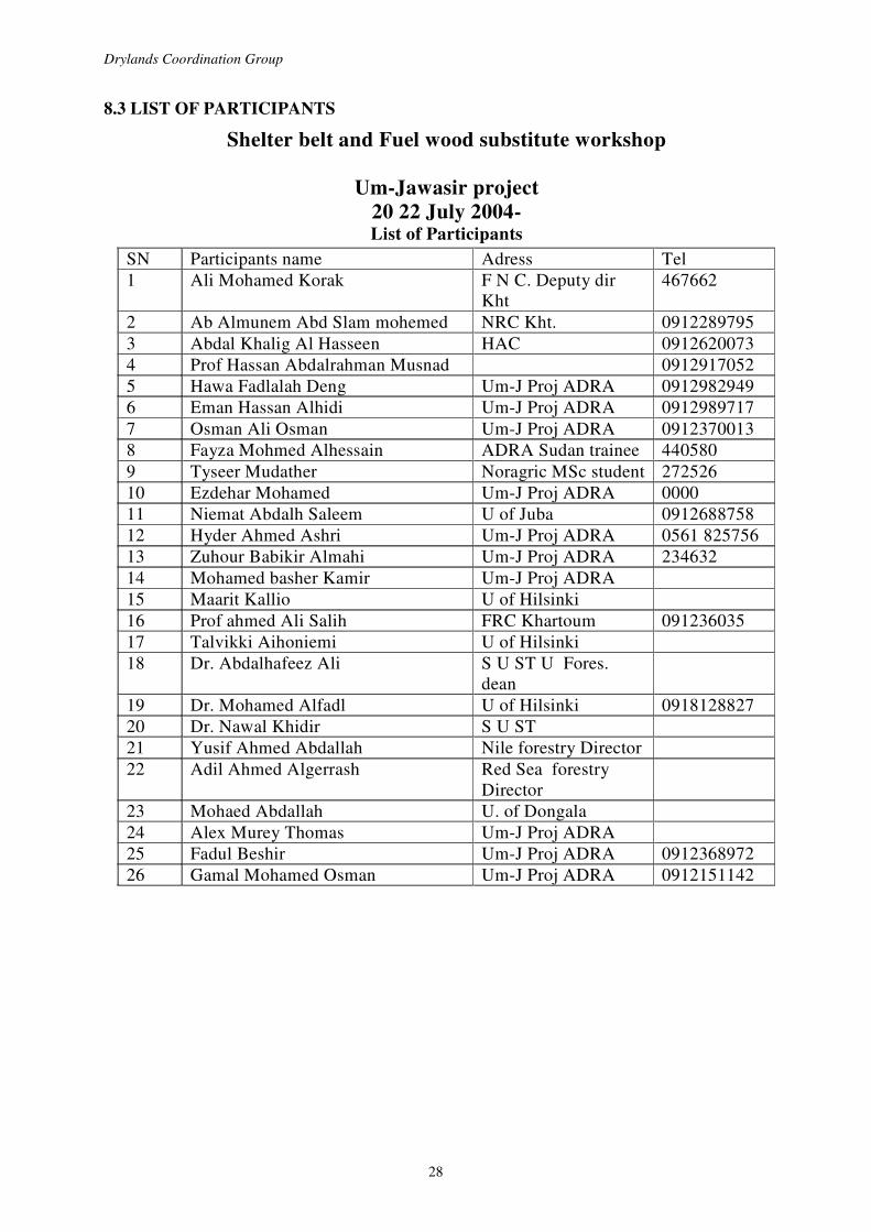
8.3 LIST OF PARTICIPANTS
Shelter belt and Fuel wood substitute workshop
Um-Jawasir project 20 22 July 2004- List of Participants
SN Participants name Adress Tel 1 Ali Mohamed Korak F N C. Deputy dir
Kht 467662
2 Ab Almunem Abd Slam mohemed NRC Kht. 0912289795 3 Abdal Khalig Al Hasseen HAC 0912620073 4 Prof Hassan Abdalrahman Musnad 0912917052 5 Hawa Fadlalah Deng Um-J Proj ADRA 0912982949 6 Eman Hassan Alhidi Um-J Proj ADRA 0912989717 7 Osman Ali Osman Um-J Proj ADRA 0912370013 8 Fayza Mohmed Alhessain ADRA Sudan trainee 440580 9 Tyseer Mudather Noragric MSc student 272526 10 Ezdehar Mohamed Um-J Proj ADRA 0000 11 Niemat Abdalh Saleem U of Juba 0912688758 12 Hyder Ahmed Ashri Um-J Proj ADRA 0561 825756 13 Zuhour Babikir Almahi Um-J Proj ADRA 234632 14 Mohamed basher Kamir Um-J Proj ADRA 15 Maarit Kallio U of Hilsinki 16 Prof ahmed Ali Salih FRC Khartoum 091236035 17 Talvikki Aihoniemi U of Hilsinki 18 Dr. Abdalhafeez Ali S U ST U Fores.
dean
19 Dr. Mohamed Alfadl U of Hilsinki 0918128827 20 Dr. Nawal Khidir S U ST 21 Yusif Ahmed Abdallah Nile forestry Director 22 Adil Ahmed Algerrash Red Sea forestry
Director
23 Mohaed Abdallah U. of Dongala 24 Alex Murey Thomas Um-J Proj ADRA 25 Fadul Beshir Um-J Proj ADRA 0912368972 26 Gamal Mohamed Osman Um-J Proj ADRA 0912151142

Experience Sharing Tour and Workshop on Shelterbelts and Fuel Wood Substitutes
29
8.4 SUDAN MAPS
KHARTOUM
K ASSALA
SHENDI
A TBARA TOKAR
SAWAKINJ
PORT SUDAN
U MJAWASIR
EL SHIRIAN
ED DABBA West Bank
ED DABBA East Bank
EL DEUEM ( Tayba )
EL OBIED ( Bara )
12o N
* Please note that all areas visited as shown in the above map are 12o North latitude.
Figure 7: Map of the Republic of the Sudan and the sites visited

Drylands Coordination Group
30
Figure 8: Mean annual rainfall

Experience Sharing Tour and Workshop on Shelterbelts and Fuel Wood Substitutes
31
Figure 9: Soil regions of Sudan

Drylands Coordination Group
32
Figure 10: Vegetation cover in Sudan

Experience Sharing Tour and Workshop on Shelterbelts and Fuel Wood Substitutes
33
List of Publications Reports: 1 A. Synnevåg, G. et Halassy, S. 1998: “Etude des indicateurs de la sécurité alimentaire dans deux sites de la zone d’intervention de l’AEN-Mali: Bambara Maodé et Ndaki (Gourma Malien)”, Groupe de Coordination des Zones Arides et Noragric, Agricultural University of Norway. 1 B. Synnevåg, G. and Halassy, S. 1998: “Food Security Indicators in Two Sites of Norwegian Church Aid’s Intervention Zone in Mali: Bambara Maoudé and N’Daki (Malian Gourma)”, Drylands Coordination Group and Noragric, Agricultural University of Norway. 2 A. Aune, J.B. and Doumbia, M.D. 1998: “Integrated Plant Nutrient Management (IPNM), Case studies of two projects in Mali: CARE Macina programme and PIDEB”, Drylands Coordination Group and Noragric, Agricultural University of Norway. 2 B. Aune, J.B. et Doumbia, M.D. 1998: “Gestion Intégrée de Nutriments Végétaux (GINV), Etude de Cas de deux projets au Mali: Programme de CARE Macina et PIDEB”, Groupe de Coordination des Zones Arides et Noragric, Agricultural University of Norway. 3 A. Berge, G., Larsen, K., Rye, S., Dembele, S.M. and Hassan, M. 1999: “Synthesis report and Four Case Studies on Gender Issues and Development of an Improved Focus on Women in Natural Resource Management and Agricultural Projects”, Drylands Coordination Group and Noragric, Agricultural University of Norway. 3 B. Berge, G., Larsen, K., Rye, S., Dembele, S.M. et Hassan, M. 1999:“Rapport de synthèse et quatre études de cas sur Les Questions de Genre et Développement d’une Approche Améliorée concernant les Femmes et les Projets d’Agriculture et de Gestion des Ressources Naturelles”, Groupe de Coordination des Zones Arides et Noragric, Agricultural University of Norway. 4 A. Sydness, M. et Ba, B. 1999: “Processus de decentralisation, développement institutionnel et reorganisation des ONG financées par la Norvège au Mali”, Groupe de Coordination des Zones Arides et Noragric, Agricultural University of Norway. 4 B. Sydness, M. and Ba, B. 1999: “Decentralisation Process, Institution Development and Phasing out of the Norwegian Involvement in Mali”, Drylands Coordination Group and Noragric, Agricultural University of Norway. 5. Waktola, A. and Michael, D.G. 1999: “Institutional Development and Phasing Out of the Norwegian Involvement, the Case of Awash Conservation and Development Project, Ethiopia”, Drylands Coordination Group and Noragric, Agricultural University of Norway. 6. Waktola, A. 1999: “Exploratory Study of Two Regions in Ethiopia: Identification of Target Areas and partners for Intervention”, Drylands Coordination Group and Noragric, Agricultural University of Norway. 7. Mossige, A. 2000: “Workshop on Gender and Rural Development – Training Manual”, Drylands Coordination Group and Noragric, Agricultural University of Norway. 8. Synnevåg, G. et Halassy, S. 2000: ”Sécurité Sémenciére: Etude de la gestion et de

Drylands Coordination Group
34
l’approvisionnement en semences dans deux villages du cercle de Ké-Macina au Mali: Kélle et Tangana”, Groupe de Coordination des Zones Arides et Noragric, Agricultural University of Norway. 9. Abesha, D., Waktola, A, Aune, J.B. 2000: ”Agricutural Extension in the Drylands of Ethiopia”, Drylands Coordination Group and Noragric, Agricultural University of Norway. 10. Sydness, M., Doumbia, S. et Diakité K. 2000: ”Atelier sur la désentralisation au Mali”, Groupe de Coordination des Zones Arides et Noragric, Agricultural University of Norway. 11. N’Dior, P. A. et Traore, N. 2000: ”Etude sur les programmes d’espargne et de credit au Mali”, Groupe de Coordination des Zones Arides et Noragric, Agricultural University of Norway. 12. Lode, K. and G. Kassa. 2001: ”Proceedings from a Workshop on Conflict Resolution Organised by the Drylands Coordination Group (DCG), November 8-10, 2000 Nazareth, Ethiopia”, Drylands Coordination Group and Noragric, Agricultural University of Norway. 13. Shiferaw, B. and A. Wolday, 2001: “Revisiting the Regulatory and Supervision Framework of the Micro-Finance Industry in Ethiopia”, Drylands Coordination Group and Noragric, Agricultural University of Norway. 14 A. Doumbia, M. D., A. Berthé and J. B. Aune, 2001: “Intergrated Plant Nutrition Management (IPNM): Practical Testing of Technologies with Farmers Groups”, Drylands Coordination Group and Noragric, Agricultural University of Norway. 14 B. Doumbia, M. D., A. Berthé and J. B. Aune, 2001: “Gestion Intégrée de Nutriments Végetaux (GINV): Tests Pratiques de Technologies avec des Groupes de Paysans”, Groupe de Coordination des Zones Arides et Noragric, Agricultural University of Norway. 15. Larsen, K. and M. Hassan, 2001: “Perceptions of Knowledge and Coping Strategies in Nomadic Communities – The case of the Hawawir in Northern Sudan”, Drylands Coordination Group and Noragric, Agricultural University of Norway. 16 A. Mossige, A., Berkele, Y. & Maiga, S., 2001: “Participation of Civil Society in the national Action Programs of the United Nation’s Convention to Combat Desertification: Synthesis of an Assessment in Ethiopia and Mali”, Drylands Coordination Group and Noragric, Agricultural University of Norway. 16 B. Mossige, A., Berkele, Y. & Maiga, S., 2001: “La Participation de la Societe Civile aux Programme d’Actions Nationaux de la Convention des Nations Unies sur la lutte contre la Desertification”, Groupe de Coordination des Zones Arides et Noragric, Agricultural University of Norway. 17. Kebebew, F., D. Tsegaye and G. Synnevåg., 2001: “Traditional Coping Strategies of the Afar and Borana Pastoralists in Response to Drought”, Drylands Coordination Group and Noragric, Agricultural University of Norway. 18. Shanmugaratnam, N., D. Mamer and M. R. Kenyi, 2002: “From Emergency Relief to Local Development and Civil Society Building: Experiences from the Norwegian Peoples’ Aid’s Interventions in Southern Sudan”, Drylands Coordination Group and Noragric, Agricultural University of Norway. 19. Mitiku, H. and S. N. Merga, 2002: Workshop on the Experience of Water Harvesting in the Drylands of Ethiopia: Principles and practices”, Drylands Coordination Group and Noragric, Agricultural University of Norway.

Experience Sharing Tour and Workshop on Shelterbelts and Fuel Wood Substitutes
35
20. Tesfai, M., V. Dawod and K. Abreha, 2002: Management of Salt-affected Soils in the NCEW « Shemshemia » Irrigation Scheme in the Upper Gash Valley of Eritrea”, Drylands Coordination Group and Noragric, Agricultural University of Norway. 21. Doumbia, M. D., A. Berthé and J. B. Aune, 2002: “Gestion Intégrée de Nutriments Végetaux (GINV): Tests Pratiques de Technologies avec des Groupes de Paysans- Rapport de la Campagne 2001”, Groupe de Coordination des Zones Arides et Noragric, Agricultural University of Norway. 22. Haidara, Y., Dembele, M. et Bacha, A. “Formation sur la lutte contre la desertificationatelier organisé par groupe de coordination des zones arides (gcoza) du 07 au 10 octobre 2002 a gossi (Mali)”, Groupe de Coordination des Zones Arides et Noragric, Agricultural University of Norway. 23. Aune, J. B. 2003. “Desertification control, rural development and reduced CO2 emissions
through the Clean Development Mechanism of the Kyoto Protocol - an impasse or a way forward?” Drylands Coordination Group and Noragric, Agricultural University of Norway. 24. Larsen, K. and Hassan, M. 2003. “Sedentarisation of Nomadic People: The Case of the Hawawir in Um Jawasir, Northern Sudan”, Drylands Coordination Group and Noragric, Agricultural University of Norway. 25. Cissé, I. et Keita, M.S. 2003. ”Etude d’impacts socio-économique et environnemental des plaines aménagées pour riziculture au Mali.” Groupe de Coordination des Zones Arides et Noragric, Agricultural University of Norway. 26. Berkele, Y. and Mossige, A. 2003. ”Indicators to Promote Civil Society’s (NGOs and CBOs) Participation in the implementation of Ethiopia’s National and Regional Action Programs of the United Nations Convention to Combat Desertification. A guideline Document”, Drylands Coordination Group and Noragric, Agricultural University of Norway. 26B. Berkele, Y. and Mossige, A. 2003. ”Indicateurs visant à promouvoir la participation de la société civile (ONG et OCB) à la mise en oeuvre en Ethiopie des Programmes d’action national et régionaux de la Convention des Nations Unies sur la lutte contre la desertification”. Drylands Coordination Group and Noragric, Agricultural University of Norway. 27. Assefa, F., Dawd, M. and Abesha, A. D. 2003. “Implementation Aspects of Integrated Pest Management (IPM): Policy and Extension Gap in Ethiopia”, Drylands Coordination Group and Noragric, Agricultural University of Norway. 28. Haile, A., Selassie, D.G., Zereyacob, B. and Abraham, B. 2003, “On-Farm Storage Studies in Eritrea”, Drylands Coordination Group and Noragric, Agricultural University of Norway. 29. Doumbia, M.D., Berthé, A., Aune, J.B. 2003, “Gestion Intégrée de Nutriments Végétaux (GINV): Tests Pratiques et Vulgarisation de Technologies”, Groupe de Coordination des Zones Arides et Noragric, Agricultural University of Norway.
30. Mossige, A. and M. Macina 2004, “Indicateurs visant à promouvoir et suivre la participation de la Société Civile (ONG et OCB) dans la mise en œuvre des Programmes d’Action National, Régional et Communal de la Convention des Nations Unies sur la lutte contre la désertification”, Groupe de Coordination des Zones Arides et Noragric, Agricultural University of Norway. 31. Tesfay, Y. and Tafere, K. 2004. “Indigenous Rangeland resources and Conflict Management by the North Afar Pastoral Groups in Ethiopia. A Pastoral Forum Organized by the Drylands Coordination Group (DCG) in Ethiopia, June 27-28, 2003, Mekelle, Ethiopia”, Drylands Coordination Group and Noragric, Agricultural University of Norway.

Drylands Coordination Group
36
32. Kebede, D. and Retta, S. 2004. “Gender, HIV/AIDS and Food Security, Linkage and Integration into Development Interventions”, Drylands Coordination Group and Noragric, Agricultural University of Norway.
33. Kidane, A., Araia, W., Ghebremichael, Z, and Gobezay, G. 2004. “Survey on striga and crop husbandry practices in relation to striga management and control of sorgum (Sorghum bicholor) in the Goluge sub zone: Lessons to be learned and creating awareness”, Drylands Coordination Group and Noragric, Agricultural University of Norway. 34. Kibreab, G., Berhane, T., and Ghezae, E. 2004. “A Study to Determine the Extent and Use of Environmental Impact Assessment of Agricultural Development Projects – A Case Study”, Drylands Coordination Group and Noragric, Agricultural University of Norway. 35. Meehan, F. 2004. “Female Headed Household in Tigray, Ethiopia. A Study Review”. Drylands Coordination Group and Noragric, Agricultural University of Norway. Proceedings: 1. Seminar on the Formation of DCG Ethiopia-Sudan. Proceedings from a Seminar organised by the Drylands Coordination Group in Nazareth, Ethiopia, April 10-12, 2000. DCG/Noragric, Agricultural University of Norway, Ås. 2. Seminar on the Formation of DCG Eritrea. Proceedings from a Seminar Hosted by the National Confederation of Eritrean Workers (NCEW) in Asmara, Eritrea, March 26th-28th, 2001. DCG/Noragric, Agricultural University of Norway, Ås. 3. Amha, W. 2001. Revisiting the Regulatory and Supervision Framework of the Microfinance Industry in Ethiopia. Proceedings from a Seminar Organised by the Relief Society of Tigray (REST), on behalf of the Drylands Coordination Group in Ethiopia and Sudan, In Mekelle, August 25, 2001. DCG/Noragric, Agricultural University of Norway, Ås. 4. Mossige, A. and Berkele, Y. 2001. Civil Society’s Participation in the National Action Program to Combat Desrtification and Mitigate the Effects of Dought in Ethiopia. Proceedings from a Workshop organised by the Drylands Coordination Group (DCG) in Ethiopia, Debre Zeit, September 13-14, 2001. DCG/Noragric, Agricultural University of Norway, Ås. 5. Maiga, S. et Mossige, A. 2001. Participation de la Societe Civile dans la Mies en Euvre Programme d’action pour la Convention Sur la Desertification (CCD) au Mali. L’atelier Organise par le Groupe Coordination sur les Zones Arides (GCOZA) Au Centre Aoua Keita, Bamako, Les 5 et 6 novembre 2001. GCOZA/Noragric, Agricultural University of Norway, Ås. 6. Do conventions need civil society? A critical review of the role of civil society in the implementation of international conventions. Proceeding from a Seminar Arranged by the Drylands Coordination Group and Forum for Development and Environment (ForUM) in Oslo, January 15th, 2002. DCG/Noragric, Agricultural University of Norway, Ås. 7. Berkele, Y. 2002. Workshop on training of trainers in UNCCD/NAP implementation in Ethiopia. Proceedings from a workshop arranged by the Drylands Coordination Group in Ethiopia, Nazareth, June 10-15, 2002, DCG/Noragric, Agricultural University of Norway, Ås. 8. Sustainable livelihoods of farmers and pastoralists in Eritrea. Proceedings from a workshop organised by DCG Eritrea in National Confederation of Eritrean Workers Conference Hall, Asmara, November 28 –29, 2002. DCG/Noragric, Agricultural University Of Norway, Ås. 9. DCG networking seminar 2002, 15th-22nd November 2002, Khartoum, Sudan. DCG/Noragric, Agricultural University of Norway, Ås.

Experience Sharing Tour and Workshop on Shelterbelts and Fuel Wood Substitutes
37
10. Soumana, D. 2003. Atelier d’information, d’exchange et de réflexion sur l’élargissement du Groupe de Coordination des Zones Arides (GCoZA) au Mali, Au Centre Aoua Keita, Bamako, Les 18 et 19 février 2003. DCG/Noragric, Agricultural University of Norway, Ås. 11. Ati, H. A.and Nimir A. A. H. 2004. Training Course On The Role Of Local Institutions In Regulating Resource Use and Conflict Management, Um Jawaseer, June 2003. DCG/Noragric, Agricultural University of Norway, Ås. 12. Berkele, Y. and Ayalew, B. 2004. Training of Trainers in Implementation of UNCCD/NAP in Ethiopia. Third Round, 10-14 Nov. 2003. DCG/Noragric, Agricultural University of Norway, Ås. 13. Macina, M. 2004. Atelier National et Campagne d’Information et de Sensibilisation sur la CCD. Un Atelier Organisé par la Coordination des Associations et ONG Féminines au Mali (CAFO) en partenariat avec le Groupe de Coordination des Zones Arides (GCoZA). Les 29-30 novembre 2004 à Bamako, Mali. DCG/Noragric, Agricultural University of Norway, Ås. 14. Musnad, H.A. and Nasr N. K. 2004. Experience Sharing Tour and Workshop on Shelterbelts and Fuel Wood Substitutes in Sudan. DCG/Noragric, Agricultural University of Norway, Ås.

Drylands Coordination Group
38
Drylands Coordination Group Addresses in Norway: ADRA Norge Akersgata 74, 0180 Oslo, Norway Tel: +47 22 11 20 80, Fax: +47 22 20 53 27 e-mail: [email protected] CARE Norge Universitetsgt. 12, 0164 Oslo, Norway Tel: +47 22 20 39 30, Fax: +47 22 20 39 36 e-mail: [email protected] Development Fund Grensen 9b, 0159 Oslo, Norway Tel: +47 23 10 96 00, Fax: .+47 23 10 96 01 e-mail: [email protected] Norwegian Church Aid P.O. Box 4544 Torshov, 0404 Oslo, Norway Tel: +47 22 22 22 99, Fax: + 47 22 22 24 20 e-mail: [email protected] Norwegian People’s Aid P.O. Box 8844 Youngstorget, 0028 Oslo, Norway Tel: + 47 22 03 77 00, Fax: + 47 22 17 70 82 e-mail: [email protected] Noragric, Centre for International Environment and Development Studies Agricultural University of Norway, P.O. Box 5003, 1432 Ås, Norway Tel: +47 64 94 99 50, Fax: +47 64 94 07 60 e-mail: [email protected]