Embed Size (px)
Citation preview

Petition for a Declaratory Ruling
Exhibits
Exhibit K – Vernal Pool Survey Technical Memorandum

Petition for a Declaratory Ruling
Exhibits
This page intentionally left blank.

\\CTMIDDAT\projects\42256.00\tech\Vernal Pool Survey\Vernal Pool_Memo_final_6-16-2017.docx
100 Great Meadow Road Suite 200 Wethersfield, CT 06109-2377 P 860.807.4300
To: Susan Moberg PWS Date: June 16, 2017
Project #: 42256.00
From: Jeff Peterson, PWS Chelsea Glinka ENV SP
Re: Vernal Pool Survey for the Tobacco Valley Solar Project Simsbury, Connecticut
Proposed Project and Site Description DWW Solar II LLC (DWW) proposed the Tobacco Valley Solar Farm (the Project) in response to the New England Clean Energy request for proposals solicited by the Connecticut Department of Energy and Environmental Protection (CT DEEP), Eversource Energy, National Grid, and Unitil. In October of 2016, DWW’s Simsbury project was selected as one of the bidders to enter final contract negotiations with Eversource Energy. The proposed Project includes a new 26.4 MW-AC solar power generating facility located on ±156 acres of land previously developed for agriculture in Simsbury, Connecticut (the Project), and it is adjacent to Connecticut Light & Power’s existing 115 kV Northeast Simsbury substation. The Project is proposed on five parcels of land identified by the Town of Simsbury Tax Assessor as G03-403-032, G03-403-012, G03-403-026-32H, G03-403-014, and H05-103-024, collectively referred to herein as the Project Site.
Wetlands and Vernal Pool Resources A delineation of inland wetlands and watercourses was completed within the Project Site between December 2016 and April 2017. This delineation determined that there are nine wetland systems with three perennial streams and four farm ponds within the Project Site. All the wetlands were investigated for vernal pool indicators by VHB staff between April 3, April 19, 2017, and May 11, 2017. The result of the surveys was that no vernal pools were identified within the Project Site. The findings are presented in more detail below.
Vernal Pool Identification Criteria The CT DEEP no longer provides a definition of vernal pool on its website.1 Calhoun and Klemens (2002) noted that there was no official definition for a vernal pool in Connecticut and cited the following guidance provided by Donahue 1995:
a) physical features and the presence of one or more obligate species,
b) water for approximately 2 months during the growing season,
c) a confined depression that lacks a permanent outlet stream,
d) no fish, and
e) dries out in most years.
The Connecticut Association of Wetland Scientist’s website notes that a DEP Task Force developed the following vernal pool draft definition:
1 http://www.ct.gov/deep/cwp/view.asp?a=2720&q=325676&depNav_GID=1654 (accessed 5/1/2017)

Ref: 42256.000 June 16, 2017 Page 2
\\CTMIDDAT\projects\42256.00\tech\Vernal Pool Survey\Vernal Pool_Memo_final_6-16-2017.docx
Vernal pool means a seasonal watercourse in a defined depression or basin, that lacks a fish population and supports or is capable of supporting breeding and development of amphibian or invertebrate species recognized as obligate to such watercourses. These species include spotted salamander, Jefferson salamander complex, marbled salamander, wood frog, and fairy shrimp.
Table 1 Vernal Pool Obligate Species
Jefferson salamander (Ambystoma jeffersonianum) Wood frog (Lithobates sylvaticus)
Spotted salamander (Ambystoma maculatum) Eastern spadefoot toad (Scaphiopus holbrookii)
Marbled salamander (Ambystoma opacum) Fairy shrimp (Eubranchipus spp.)
These criteria are similar, although the second does not require the pool to dry in most years.
Methodology to Identify Vernal Pools Vernal pools were surveyed in April of 2017 by traversing the wetlands to find pools that could hold amphibians. Once potential vernal pools were identified, VHB logged auditory cues (e.g. wood frog breeding calls). Wearing waders VHB dip netted within the pools looking primarily for wood frog and spotted salamander adults, egg masses or spotted salamander spermatophores along the pool edge. VHB focused the surveys most intensely in areas where substrate, such as submerged branches, beds of reed-canary grass or other emergent species were present. Dip netting, minnow traps, baited fishing lines and visual surveys using polarized glasses were used to determine the presence/absence of fish. Photographs were taken of the pools investigated and of specimens captured during sampling.
Findings The only potential vernal pools observed within the Project Site consisted of four farm ponds constructed as part of the irrigation system that supported the crop production on the parts of the Project Site managed as tilled field. Two types of farm ponds are present: impoundments constructed in perennial streams and ponds excavated into groundwater. All four ponds were found to support fish populations and therefore are not vernal pools. Wood frog were encountered in puddles which had formed during snow melt in the access drive from County Road just northwest of Litchfield Drive. These puddles had dried entirely by April 19th such that successful breeding could not occur in them.
VHB found wood frog egg masses and a small number of chorusing adults at the edge of the southernmost Farm Pond 4. This pond held a large population of an unidentified juvenile Centrarchid (Lepomis sp. bluegill or sunfish) and larger fish up to an estimated five inches in length were observed from the shore. A description of each resource area investigated is provided below.

Ref: 42256.000 June 16, 2017 Page 3
\\CTMIDDAT\projects\42256.00\tech\Vernal Pool Survey\Vernal Pool_Memo_final_6-16-2017.docx
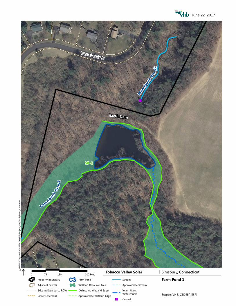
Farm Pond 1
This irrigation pond is in the northwestern portion of the Project Site approximately 550 feet south east of the intersection of Munnisunk Drive and Tim Clark Circle. This pond is impounded by an earthen dam constructed across Munnisunk Brook. The surface area of the pond is 1.2 acres. A large corrugated metal riser pipe serves as the outlet control for the level of the pond. The pond is several feet deep and cannot be crossed while wearing waders. Still backwater areas appear to provide suitable vernal pool habitat.
VHB observed adult green frog (Lithobates clamitans) and northern spring peeper (Pseudacris crucifer) along the shores of this pond. No adults or egg masses of any vernal pool obligate species were found during the perimeter search. Depredated mussel shells were common along the shoreline of the pond. VHB observed fish in the pond and captured juvenile Centrarchids (Lepomis sp.) in a minnow trap and adult golden pond shiners (Notemigonus crysoleucas). Photographs are appended. The presence of fish in the pond means that this resource area is not a vernal pool.
Farm Pond 2
This excavated farm pond also is part of the irrigation system for the farm. Farm Pond 2 is located approximately 500 feet northeast of the cul-de-sac at the end of Berkshire Way. The water surface area of the pond is about one acre. The pond is too deep to wade more than 15 to 20 feet in from the shoreline. This pond has no natural inlet or outlet. An irrigation line from Pond 1 is used to supply water to this pond and water in this pond is used to irrigate crops.
Perimeter visual and dip-net surveys did not reveal any evidence of obligate species in this resource area. The northern shoreline of the pond includes an area of floating reed canary-grass that appeared particularly suitable for wood frog or spotted salamander breeding. During the final inspection on April 19th, this area was covered with strings of American toad (Anaxyrus americanus) eggs. However, no evidence of wood frog or spotted salamanders breeding was observed.
Fish presence was suspected as the pond was visited by a pair of hooded mergansers and a belted kingfisher during the investigation. Dip netting produced second year green frog larva with leg buds and juvenile brown bullhead (Ameiurus nebulosus). Fleeting observations of larger fish and schools of juvenile centrarchids were also made as they broke the water surface while feeding or escaping predation.
The absence of evidence of use by vernal pool obligate species and presence of fish led to the conclusion that this resource area is not a vernal pool.
Farm Pond 3
This impoundment constructed on Saxton Brook is about one third of an acre in area. Farm Pond 3 is located approximately 700 feet west of the temporary cul-de-sac at the end of Casterbridge Crossing. It was constructed by a combination of excavation and construction of an earth dam across the stream. The earth dam has partially breached in the northern corner of the pond and water flows through the pond at a lower elevation. An intake structure for diverting stream flow for use in irrigation remains in this pond.

Ref: 42256.000 June 16, 2017 Page 4
\\CTMIDDAT\projects\42256.00\tech\Vernal Pool Survey\Vernal Pool_Memo_final_6-16-2017.docx
Our visual and dipnet surveys around the entire pond perimeter did not produce any evidence of use by an obligate species. We were unable to capture fish with a baited minnow trap placed at several locations in the pond. VHB observed a belted kingfisher (Megaceryle alcyon) catch and consume a small fish. During our multiple observations, VHB found the pond is frequented by a pair of hooded mergansers (Lophodytes cucullatus) which include small fish in their diet. Finally, on May 11, 2017 large schools of juvenile centrarchids were observed close to shore in the northwest corner of the pond.
VHB concluded that this small pond constructed in a perennial watercourse is not a vernal pool.
Farm Pond 4
This excavated farm pond is the southernmost of the four potential vernal pools investigated in the Project Site. It is approximately 800 feet south of the intersection of Kilbourn Road with Hoskins Road. This pond has no inlet but an ephemeral outlet was flowing at the time of the inspection. The pond has a surface area of about 0.4 acres.
This pond held a small raft of wood frog eggs (estimated 6–8) along its western shoreline where a red maple sapling dipped into the water. A small group of adults would chorus when sunlight broke from behind clouds. No evidence of spotted salamander breeding was observed.
Painted turtle (Chrysemys picta) was also observed sunning in the pond on May 11, 2017. Inspection of the pond found that it held a large population of Centrarchids (Lepomis sp.) in multiple age classes. Despite the presence of wood frog, the presence of these fish led VHB to conclude that Farm Pond 4 is not a vernal pool.
Conclusions No vernal pools were found within the limits of the property being considered for the Project. Wetland systems do extend beyond the property limits and vernal pools may occur off-site near the Project. A summary of findings is presented in Table 1 below.
Table 2 Summary of Findings
Pond ID Area (ac) Inlet/Outlet
Flowing Obligate Species
Fish Present
Vernal Pool Criteria Met
Farm Pond 1 1.2 Yes None detected Yes No Farm Pond 2 1.0 No None detected Yes No Farm Pond 3 0.3 Yes None detected Yes No Farm Pond 4 0.4 No inlet; Outlet-Yes Wood frog1 Yes No
1: An estimated six to eight egg masses and small group of chorusing wood frog observed near northwest corner of Farm Pond 4

Ref: 42256.000 June 16, 2017 Page 5
\\CTMIDDAT\projects\42256.00\tech\Vernal Pool Survey\Vernal Pool_Memo_final_6-16-2017.docx
References: Calhoun, A. J. K. and M. W. Klemens. 2002. Best development practices: Conserving pool-breeding amphibians in residential and commercial developments in the northeastern United States. MCA Technical Paper No. 5, Metropolitan Conservation Alliance, Wildlife Conservation Society, Bronx, New York.
Connecticut Association of Wetland Scientists vernal pool web page fact sheet: http://www.ctwetlands.org/forms/CAWS_VernalPoolMonitoring_FactSheet.pdf
Donahue, D. F. 1996. A guide to the identification and protection of vernal pool wetlands in Connecticut. University of Connecticut Cooperative Extension Program.
Klemens, M. W. 1993. Amphibians and reptiles of Connecticut and adjacent regions. State Geological and Natural History Survey of Connecticut, Bulletin No. 112, Connecticut Department of Environmental Protection, Hartford, CT.
Whitworth, W. R. 1996. Freshwater Fishes of Connecticut. 2nd ed. State Geological and Natural History Survey of Connecticut Bulletin 114, Connecticut Department of Environmental Protection, Hartford, CT.

Ref: 42256.000 June 16, 2017 Page 6
\\CTMIDDAT\projects\42256.00\tech\Vernal Pool Survey\Vernal Pool_Memo_final_6-16-2017.docx
Farm Pond 1 Photos Farm Pond 1 - Photo 1 Description:
An intermittent stream enters Farm Pond 1 from the southeast. This area looked likely to provide vernal pool habitat, however no evidence of obligate species was found in this pond. Munnisunk Brook, a perennial tributary to the Farmington River, enters the pond from its northwestern corner that is not visible in this photograph.
Farm Pond 1 - Photo 2 Description:
View of the corrugated metal riser pipe that serves as the outlet at Farm Pond 1. The pond is an impoundment of Munnisunk Brook and another intermittent tributary. This photo was taken from the earth dam at the northeast side of the pond looking southwest across the pond.

Ref: 42256.000 June 16, 2017 Page 7
\\CTMIDDAT\projects\42256.00\tech\Vernal Pool Survey\Vernal Pool_Memo_final_6-16-2017.docx
Farm Pond 1 - Photo 3 Description: Adult golden pond shiners are present in Pond 1. The presence of these fish confirms the pond is not a vernal pool.
Farm Pond 1 - Photo 4 Description:
Spring peeper observed along the pond’s shoreline. Spring peeper is not an obligate vernal pool species.
Ref: 42256.000 June 16, 2017 Page 8
\\CTMIDDAT\projects\42256.00\tech\Vernal Pool Survey\Vernal Pool_Memo_final_6-16-2017.docx
Farm Pond 1 - Photo 5 Description: A juvenile Centrarchid was captured in a minnow trap placed in Farm Pond 1.

Ref: 42256.000 June 16, 2017 Page 9
\\CTMIDDAT\projects\42256.00\tech\Vernal Pool Survey\Vernal Pool_Memo_final_6-16-2017.docx
Farm Pond 2 Photos Farm Pond 2 - Photo 1 Description:
Farm Pond 2 was excavated below the water table next to tobacco barns. This irrigation pond held fish and second year green frog larvae indicating it does not dry.
Farm Pond 2 - Photo 2 Description:
Dip netting did not result in any vernal pool obligate species captures, but three brown bullhead juveniles were captured, all similar in size to the specimen in this photo.
Ref: 42256.000 June 16, 2017 Page 10
\\CTMIDDAT\projects\42256.00\tech\Vernal Pool Survey\Vernal Pool_Memo_final_6-16-2017.docx
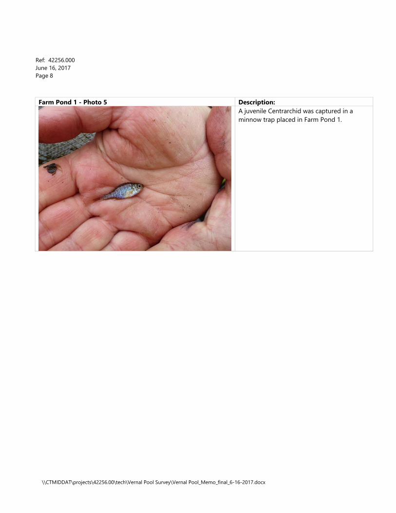
Farm Pond 2 - Photo 3 Description: Second year green frog larvae were also common. This robust individual was beginning to develop hind legs.
Farm Pond 2 - Photo 4 Description:
American toad use this pond to spawn, but are not obligate vernal pool species. American toad preferred the submerged reed canary grass found along the north side of the pond as a substrate for egg deposition. Large schools of American toad larvae such as seen in this photographed were present on May 11, 2017.

Ref: 42256.000 June 16, 2017 Page 11
\\CTMIDDAT\projects\42256.00\tech\Vernal Pool Survey\Vernal Pool_Memo_final_6-16-2017.docx
Farm Pond 2 - Photo 5 Description: This photo shows the existing condition along the north side of Pond 2 where a shelf of partially submerged reed canary grass attracted spawning American toad.

Ref: 42256.000 June 16, 2017 Page 12
\\CTMIDDAT\projects\42256.00\tech\Vernal Pool Survey\Vernal Pool_Memo_final_6-16-2017.docx
Farm Pond 3 Photos Farm Pond 3 - Photo 1 Description:
Farm Pond 3 is an impoundment along Saxton Brook (foreground). It was constructed through a combination of excavation and construction of an earth impoundment.
Farm Pond 3 - Photo 2 Description:
No evidence of use by obligate vernal pool species was found. While we were unable to capture and identify fish in the pond, we did witness a belted kingfisher capture and consume a fish from this pond. Painted turtles were photographed sunning in this pond on May 11, 2017. This instream impoundment is not a vernal pool.

Ref: 42256.000 June 16, 2017 Page 13
\\CTMIDDAT\projects\42256.00\tech\Vernal Pool Survey\Vernal Pool_Memo_final_6-16-2017.docx
Farm Pond 4 Photos Farm Pond 4 - Photo 1 Description:
View of Farm Pond 4 looking southwest towards outlet. The pond was constructed by cutting into the northern hillside and constructing a berm along the southern half of the pond.
Farm Pond 4 - Photo 2 Description:
View of Farm Pond 4 looking north along the western bank. A small raft of wood frog eggs was found attached to the downed red maple sapling visible near the far corner of the pond.
Ref: 42256.000 June 16, 2017 Page 14
\\CTMIDDAT\projects\42256.00\tech\Vernal Pool Survey\Vernal Pool_Memo_final_6-16-2017.docx
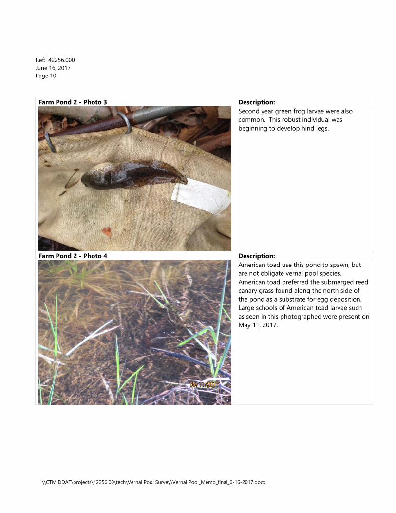
Farm Pond 4 - Photo 3 Description: A small raft of wood frog eggs was attached to the branches of a red maple sapling that had recently bent into the pond.
Farm Pond 4 - Photo 4 Description:
Farm Pond 4 supported a large population of an unidentified Centrarchid (Lepomis sp.). These juveniles were caught in a baited minnow trap placed in the pond. Larger fish were also observed within the pond.
Ref: 42256.000 June 16, 2017 Page 15
\\CTMIDDAT\projects\42256.00\tech\Vernal Pool Survey\Vernal Pool_Memo_final_6-16-2017.docx
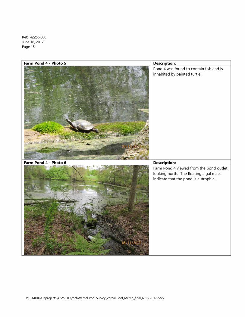
Farm Pond 4 - Photo 5 Description: Pond 4 was found to contain fish and is inhabited by painted turtle.
Farm Pond 4 - Photo 6 Description:
Farm Pond 4 viewed from the pond outlet looking north. The floating algal mats indicate that the pond is eutrophic.

!(
!(
!(
!(
!(!(
!(!(
!(!(!(
!(
!(
!(
!(!(
!(!(
!(
!(
!(
!(
!(
!(
!(!(
!(!(
!(!(!(!(
!(!(
Mun nisunk B rook
Munnisun
k Bro
ok
Bissell B rook
Saxton Brook
Saxton Br ook
")
")
")
")")
")")")")
3-1003-107
GranbySimsbury
1
2
3
4
W-5
W-2
W-6W-6
W-6
W-6
W-8W-9
W-1
W-1
W-4
W-1
W-3
W-7
6-198
6-5096-501
6-100
5-1005-110
4-1004-130
2-137
2-1001-203
1-1001-300
1-310
1-400 100-480
6-611
6-600
6-700
6-722
8-180
8-100
9-1109-100
7-1007-107
6-300
6-414
6-2006-223Ho
ward
St
Hawks Ln
Field Dr
Kilbo
urn Rd
Weatherly Rd
Brianwood Ln
Hopm
eado
w St
Tuller
Ely Ln
OldSim
sbury
Rd Salmon Brook St
Flintlo
ck
Ridge
Rebe
cca
Ln
Westwood Dr
Oakwood Dr Ice Pond Rd
Simsbury Pines
Gretel Ln
Dorset Crossing
North
Dr
Halwood DrOx
Yoke Dr
Willard St
Musket Trl
Gordon St
Powder Horn Dr
Wesco
tt Rd
Litchfield Dr
Saxto
nBroo
k Dr
Old Barge Rd
Squad
ron Lin
e Rd
HopmeadowSt
County Rd
Hoskins Rd
Munn
isunk
Dr
Ely Pl
BrettonwoodDr
Cente
rwoo
d RdKnoll
wood
Cir
BrettonwoodDrTim Clark Cir
Berkshire Way
Tobacco Valley Solar Simsbury, ConnecticutWetland Delineation Map
i 0 650 1300325 Feet
June 20, 2017\\N
HBED
ATA\
chec
kin\42
256.0
0\GIS\
Projec
t\May
2017
\Wetl
and_
Reso
urces.
mxd
Property BoundaryAdjacent ParcelsTown BoundaryExisting Eversource ROWExisting Gravel Road
Wetland Resource AreaFarm PondDelineated Wetland EdgeApproximate Wetland EdgeStreamApproximate Stream
!( Wetland Flag ") Culvert
Source: VHB, CTDEEP, ESRI
")
Munnisunk Br
ook
Munnis
unk Bro
ok
Earth Dam
W-1
Munnisunk Dr
Farm Pond 1i 0 150 30075 Feet
\\NHB
EDAT
A\ch
eckin
\4225
6.00\G
IS\Pro
ject\M
ay20
17\Po
nd_A
reas.m
xdJune 22, 2017
Tobacco Valley Solar Simsbury, ConnecticutProperty BoundaryAdjacent ParcelsExisting Eversource ROWSewer Easement
Farm PondWetland Resource AreaDelineated Wetland EdgeApproximate Wetland Edge
StreamApproximate StreamIntermittent Watercourse
") CulvertSource: VHB, CTDEEP, ESRI

Pond Spoils
W-5
W-2
W-4
Berkshire Way
Farm Pond 2i 0 150 30075 Feet
\\NHB
EDAT
A\ch
eckin
\4225
6.00\G
IS\Pro
ject\M
ay20
17\Po
nd_A
reas.m
xdJune 22, 2017
Tobacco Valley Solar Simsbury, ConnecticutProperty BoundaryAdjacent ParcelsExisting Eversource ROWSewer Easement
Farm PondWetland Resource AreaDelineated Wetland EdgeApproximate Wetland Edge
StreamApproximate StreamIntermittent Watercourse
") CulvertSource: VHB, CTDEEP, ESRI

")")
")")
")")
Earth
Berm
Sax t onB
rook
Sax
ton Brook
W-6W-6
W-6
Farm Pond 3i 0 150 30075 Feet
\\NHB
EDAT
A\ch
eckin
\4225
6.00\G
IS\Pro
ject\M
ay20
17\Po
nd_A
reas.m
xdJune 22, 2017
Tobacco Valley Solar Simsbury, ConnecticutProperty BoundaryAdjacent ParcelsExisting Eversource ROWSewer Easement
Farm PondWetland Resource AreaDelineated Wetland EdgeApproximate Wetland Edge
StreamApproximate StreamIntermittent Watercourse
") CulvertSource: VHB, CTDEEP, ESRI

Bi ss ell Bro o k
Pond Spoils
W-8
Farm Pond 4i 0 150 30075 Feet
\\NHB
EDAT
A\ch
eckin
\4225
6.00\G
IS\Pro
ject\M
ay20
17\Po
nd_A
reas.m
xdJune 22, 2017
Tobacco Valley Solar Simsbury, ConnecticutProperty BoundaryAdjacent ParcelsExisting Eversource ROWSewer Easement
Farm PondWetland Resource AreaDelineated Wetland EdgeApproximate Wetland Edge
StreamApproximate StreamIntermittent Watercourse
") CulvertSource: VHB, CTDEEP, ESRI