Embed Size (px)
Citation preview
Evaporite Geology of Fifth Ore Zone Carlsbad District Southeastern New Mexico
GEOLOGICAL SURVEY BULLETIN 1252-B
Evaporite Geology of Fifth Ore Zone Carlsbad District Southeastern New MexicoBy CHARLES L. JONES and BETH M. MADSEN
CONTRIBUTIONS TO ECONOMIC GEOLOGY
GEOLOGICAL SURVEY BULLETIN 1252-B
A study of complex evaporite stratigraphy and potash occurrences
UNITED STATES GOVERNMENT PRINTING OFFICE, WASHINGTON : 1968
UNITED STATES DEPARTMENT OF THE INTERIOR
STEWART L. UDALL, Secretary
GEOLOGICAL SURVEY
William T. Pecora, Director
For sale by the Superintendent of Documents, U.S. Government Printing Office Washington, D.C. 20402
CONTENTS
Page
Abstract _____________________________ 1Introduction _____________________________________ 1
Purpose and scope ______________________________ 1Area of investigation ____________________________ 2Method of study and presentation ___________________ 2Acknowledgments _____________________________ 6Previous work _______________________________ 6
Synopsis of evaporite geology __________________________ 7Geology of Fifth ore zone _________________________ 10
Stratigraphy _______________________________. 10Lithology ______________________________ _. 12Internal structure _________________________. 14Thickness _______________________________. 15Stratigraphic relations ______________________. 15
Potash occurrences __________________________. 16Massive deposits ____________________________. 16Disseminated deposits ____________________. 39
References cited ________________________________. 20
ILLUSTRATIONS
[Plates in pocket]
PLATE 1. Simplified geologic map of Fifth ore zone.2. Stratigraphic diagram showing general character and relations of
Upper Permian rocks.3. Stratigraphic diagram of Fifth ore zone.
PageFIGURE 1. Index map of southeastern New Mexico ___________ B3
III

CONTRIBUTIONS TO ECONOMIC GEOLOGY
EVAPORITE GEOLOGY OF FIFTH ORE ZONE CARLSBAD DISTRICT, SOUTHEASTERN NEW MEXICO
By CHARLES L. JONES and BETH M. MADSEN
Abstract
Analysis of cores, samples, and geophysical well logs shows that the Fifth ore zone of the Carlsbad district is a laterally persistent unit of halite, argillaceous halite, and claystone containing a variety of potassic minerals and rocks.
The potash is in massive and disseminated deposits, and in both types preservation of bedding and other stratigraphic details is virtually complete. The two types of deposits are characterized by closely similar suites of potassic bittern minerals, but only the massive deposits contain the langbeinitic and sylvitic saline rocks of economic importance. The main deposit of these rocks thickens and thins irregularly along its length; it varies markedly in lithology from place to place; and in form it is a labyrinthic complex, not a simple seam or blanketlike deposit in a layered sequence of evaporitic rocks.
INTRODUCTION
PURPOSE AND SCOPE
The Carlsbad district, in the southeastern part of New Mexico, is widely known for its output of potassium salts from ore zones in the Upper Permian Salado Formation. The district completely dominates the mining and processing of potassic ores in the United States; its mines produce annually nearly one-fourth of the world's potash supply. The aggregate output from the mines in the brief period of 32 years (1931-63) amounts to 205 million tons of potassic ores from which potassium salts worth roughly $1.2 billion have been extracted. The bulk of the ore tonnage was sylvitic ore from mines throughout the area. The remainder
Bl
B2 CONTRIBUTIONS TO ECONOMIC GEOLOGY
was langbeinitic ore from a single mine in the southern part of the district, obtained in part from a potassic salt bed in the Salado long known as the Fifth ore zone, in which sylvitic and langbeinitic ores are about equally important.
The present report describes the Fifth ore zone in an area where the geologic structure is simple, and the evaporite strati graphy and potash occurrences are complex. The megascopic features, spatial distribution, and interrelationship of the evapo- ritic rocks and ores are emphasized. The origin and subsequent events in their history are not discussed here, because to do so would require an extended description and discussion of other sylvite-langbeinite-bearing ore zones in the Salado Formation. Owing to the complex stratigraphy of the ore zone, it has been necessary to study many sections to determine and analyze the distribution and relationship of the evaporitic rocks and ores. This study will aid, indirectly, in the search for potassic ore bodies by providing basic data and mapping that can be used by geolo gists and engineers engaged in exploration for potassium salts in the Carlsbad district.
AREA OF INVESTIGATION
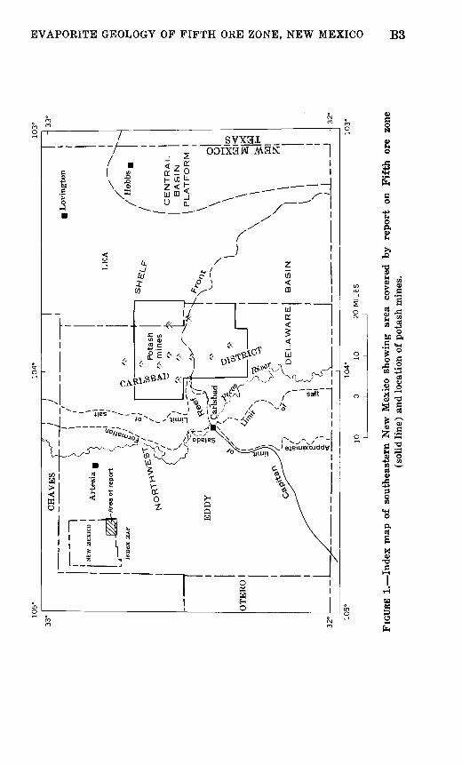
The term "Carlsbad district" is here applied to a broad area of widely spaced potash mines in the Pecos valley of southeastern New Mexico. The district lies east of the Pecos River at the lati tude of Carlsbad, N. Mex. (fig. 1), and includes wide stretches of the gypsiferous lowlands and adjoining sandy plains which flank the Pecos along much of its course through New Mexico and Texas. The gypsiferous lowlands form an irregular karst plain with many isolated depressions, linear draws, and other solution-subsidence features related to the removal of gypsum, salt, and other materials of the Rustler and Salado Formations of Late Permian (Ochoa) age. Low scarps capped by beds of sandstone and other resistent rocks border the lowlands and generally mark the western limit of sandy plains, where the bed rock consists of the Upper Permian Dewey Lake Redbeds and other red-bed formations of Triassic and Quaternary age. Across much of the sandy plains, the surface is covered with thick deposits of loose, windblown sands; the irregular, hummocky sand-dune topography has moderate relief.
METHOD OF STUDY AND PRESENTATION
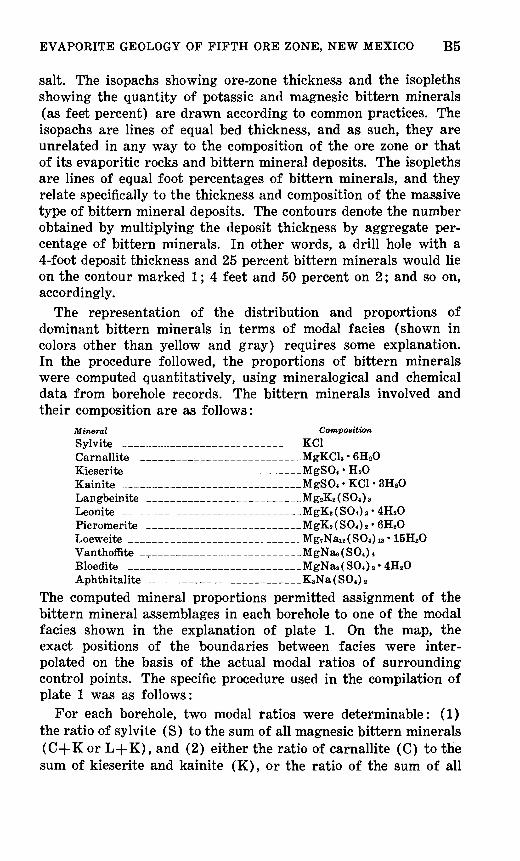
The present investigation is a study of subsurface geology that is based primarily on drill cores from about 350 exploratory
Itt> 89 * 01m ri-
|32' I*
oo83s-£B O
8-1W crq
§
3-
OOIX3W M3N '3NOZ 3HO
B4 CONTRIBUTIONS TO ECONOMIC GEOLOGY
borings for potassium salts in the Carlsbad district. For purpose of comparison, drill cores from borings in southeastern Chaves County and southern Lea County, N. Mex., were examined also. In addition, the sections of the Fifth ore zone exposed along the walls of rooms and entries on the 800 level of the International Minerals & Chemical Corp. mine were studied.
The method of study and the terms used in describing drill cores and rocks seen in mine workings are similar to those commonly applied to rocks on the outcrop. Individual rock units or layers in the cores or mine faces are distinguished on the basis of mineral composition, color, texture, and structure; details of these properties are determined from chemical analyses and from megascopic and microscopic examination of core or chip samples and thin sections. Minerals are identified from crushed grains in immersion oils under the petrographic microscope. The refrac tive indices and optical properties of all the evaporitic minerals found in the ore zone are normal and agree very closely with the values cited by Schaller and Henderson (1932) in their mineralogic description of drill cores from the Carlsbad area and other parts of the southeastern New Mexico potash field.
The geologic map of the Fifth ore zone in the Carlsbad district (pi. 1), which accompanies this report, is simplified and somewhat generalized to accommodate a wide variety of subsurface data. This map includes data derived from study of the 350 cores examined plus information from nearly 700 additional borings. Bed-by-bed correlation and analysis of core, sample, and geo physical well logs (including radioactivity, sonic, electric, and caliper logs) of the many borings involves considerable uncer tainty and many limitations, but the map is believed to portray salient geologic features of the ore zone in this area of complex potash occurrences. The map brings together, in a readily com prehended form, a part of the great mass of subsurface data that has been acquired by leaseholders and by the U.S. Geological Survey during more than four decades of exploration for potas sium salts in the Carlsbad area.
The geologic map shows for the most part the distribution in the Fifth ore zone of mineralized and barren (unmineralized) rock salt and the argillic residue now found where there has been extensive subsurface solution. The details of lateral variations in the ore zone are shown by patterns, contours, and colors. The fine and coarse ruling indicates the type of bittern mineral deposit (massive or disseminated) found in the areas of mineralized rock
EVAPORITE GEOLOGY OF FIFTH ORE ZONE, NEW MEXICO B5
salt. The isopachs showing ore-zone thickness and the isopleths showing the quantity of potassic and magnesic bittern minerals (as feet percent) are drawn according to common practices. The isopachs are lines of equal bed thickness, and as such, they are unrelated in any way to the composition of the ore zone or that of its evaporitic rocks and bittern mineral deposits. The isopleths are lines of equal foot percentages of bittern minerals, and they relate specifically to the thickness and composition of the massive type of bittern mineral deposits. The contours denote the number obtained by multiplying the deposit thickness by aggregate per centage of bittern minerals. In other words, a drill hole with a 4-foot deposit thickness and 25 percent bittern minerals would lie on the contour marked 1; 4 feet and 50 percent on 2; and so on, accordingly.
The representation of the distribution and proportions of dominant bittern minerals in terms of modal facies (shown in colors other than yellow and gray) requires some explanation. In the procedure followed, the proportions of bittern minerals were computed quantitatively, using mineralogical and chemical data from borehole records. The bittern minerals involved and their composition are as follows:
Mineral Composition
Sylvite ____________________KC1 Carnallite __________________MgKCU 6H20 Kieserite ___________________MgSO* H 20 Kainite ____________________MgSO* KC1 3H 20 Langbeinite _________________Mg2K2 (S04) 8 Leonite ____________________MgK^SOOs- 4H20 Picromerite __________________MgK2 (S04) 2 - 6H20 Loeweite ___________________Mg7Nai2 (S04)i8 ' 15H20 Vanthoffite _,_________________MgNaefSO*)* Bloedite ____________________MgNa2 (S04> 2 4H20 Aphthitalite _________________KaNafSO*),,
The computed mineral proportions permitted assignment of the bittern mineral assemblages in each borehole to one of the modal facies shown in the explanation of plate 1. On the map, the exact positions of the boundaries between facies were inter polated on the basis of the actual modal ratios of surrounding control points. The specific procedure used in the compilation of plate 1 was as follows:
For each borehole, two modal ratios were determinable: (1) the ratio of sylvite (S) to the sum of all magnesic bittern minerals (C+K or L+K), and (2) either the ratio of carnallite (C) to the sum of kieserite and kainite (K), or the ratio of the sum of all
B6 CONTRIBUTIONS TO ECONOMIC GEOLOGY
potassium and sodium sulfate-bearing bittern minerals (L) (such as langbeinite and loeweite) to the sum of kieserite and kainite (K). On completion of this step, contour maps showing variations in each of the modal ratios were prepared independently of one another and superposed. Then, boundaries between mineralog- ically distinct parts of the massive bittern mineral deposits were drawn in accordance with the modal-facies classification shown in the map explanation. This manner of depicting the distribution and proportions of dominant bittern minerals or mineral groups is patterned closely after the fairly conventional lithofacies analytical technique in which lithic-ratio contour maps are super posed and graphic patterns used to represent lithofacies. On plate 1, different colors are used to represent certain classes or types of deposit bittern mineralogy. The key to the colors is the classification chart in the map explanation, which shows the nature of the individual classes or types of modal facies as well as their relationship.
ACKNOWLEDGMENTS
The study and mapping of the Fifth ore zone would have been impossible without the cooperation of mining companies and leaseholders in the Carlsbad district. Every facility required in the examining and sampling of drill core was freely extended by all companies and leaseholders, and we acknowledge the great mass of essential lithologic, mineralogic, and chemical data made available from well logs and exploration records of the American Potash & Chemical Corp., Continental Potash Corp., Duval Corp., International Minerals & Chemical Corp., Kermac Potash Corp., National Potash Co., Potash Company of America, Southwest Potash Corp., United States Borax & Chemical Corp., and W & W Drilling Co.
PREVIOUS WORK
The geology of the Pecos valley in southeastern New Mexico in general and of the rock salt and associated potash deposits in particular has been described by many authors. Hoots (1925) and Barton (1928) made regional reconnaissance studies in con nection with the early exploration for potassium salts. Subsequent studies by Lang (1937), Kroenlein (1939), and Adams (1944) contributed greatly to present knowledge of the geology and stratigraphy of salt-bearing formations in the region. The saline minerals of the formations were investigated by Schaller and
EVAPORITE GEOLOGY OF FIFTH ORE ZONE, NEW MEXICO B7
Henderson (1932), and various details of the occurrence and regional distribution of the potassic minerals and rocks were presented by Mansfield and Lang (1935) and by Jones (1954). Stipp and Haigler (1957) outlined the structural geology of southeastern New Mexico and included a structure contour map of a major part of the area underlain by salt-bearing formations.
Other work, related specifically to the potash deposits, involved studies based largely on mine examinations. Ageton (1936) described and classified-various types of salt occurrences found in sylvitic ore bodies. In more recent years, Cathcart (1949) discussed the occurrence of picromerite-bearing fractures in langbeinitic lenses and enclosing rock salt, and Dunlap (1951) gave a detailed account of local variations in thickness and type of rock within salt beds found on the 800 level of the International Minerals & Chemical Corp. potash mine.
SYNOPSIS OF EVAPORITE GEOLOGY
The Pecos valley in the vicinity of the Carlsbad district is under lain chiefly by gypsum and other rocks of the predominantly evaporitic Ochoa Series of Late Permian age. These rocks include three evaporite formations, from oldest to youngest, the Castile, the Salado, and the Rustler. They have a combined thickness of about 4,000 feet. Neither the Castile nor the Rustler Formation is economically important, and they are considered here only to the brief extent required to indicate the general character and nature of the Ochoa Series to which ore-bearing salt beds in the Salado Formation belong. The salt beds are not exposed in out crops of the area, but they have been penetrated in exploratory borings for potassium salts and petroleum.
Considered broadly, the Castile, Salado, and Rustler Formations are cyclical subdivisions of a major evaporite sequence between two groups of dissimilar rocks, of which the lower comprises the Capitan Limestone and associated carbonate-bearing formations of pre-Ochoa (Guadalupe) age, and the upper comprises the Dewey Lake Redbeds of Ochoa age. As shown schematically on plate 2, they correspond in large measure to successive stages or zones in a crude three-part vertical transition from limestone and anhydrite, through rock salt and associated potash deposits, to anhydrite and dolomite. In general, the three formations repre sent a transitional zone between underlying reefoid and normal marine limestones and overlying red beds deposited under brack ish or restricted marine conditions. They are composed mainly
B8 CONTRIBUTIONS TO ECONOMIC GEOLOGY
of anhydrite and rock salt, but include a series of evaporitic rocks that range in composition from calcitic limestone to complex potassic and magnesic rocks and ores.
Of the three evaporite formations, the Salado is probably the most distinctive; it is predominantly rock salt and contains many potassic ores and rocks of scientific and economic interest. Thin to thick beds of magnesitic anhydrite and other sulfatic evaporite rocks are present, and there is invariably a gossanlike "caprock" or leached zone of gypsiferous and clayey residue in areas where subsurface solution has removed halite and other readily soluble salts from one or more parts of the formation. Equally character istic of the formation, but of greater significance in unraveling its history, is a coarse and fine layering of halite and other evapo- rites which shows that there were many cycles of flooding and desiccation during Salado time. Repetition of lithic sequence is particularly common, and thin to thick units of rhythmically inter- layered halite and argillaceous halite alternate with generally thinner units of anhydrite and other evaporites. These anhydritic units are rhythmically layered sequences of magnesite and some sulfatic or chloridic evaporite, such as anhydrite or halite, pseudo- morphous after gypsum. A thin claystone layer is at the base of practically every anhydritic unit, and these claystones seem to form the basal member of a sedimentation or cyclothemic evapo rite unit in which there is a transition upward from magnesite, through anhydrite, polyhalite, or glauberite, to halite and argil laceous halite. The argillaceous halite may give way gradatiorially upward to claystone, but more commonly, it is sharply terminated above by a fairly even, clear-cut corrosion surface that carries a thin coating or film of claystone.
All the potassic ores so far known in the Salado Formation are found in bittern mineral deposits of one general massive type; these deposits are restricted to certain groups of mineralized salt beds, or ore zones, within a fairly small stratigraphic interval, about 120-300 feet thick, near the middle of the formation (pi. 2). The deposits are typically labyrinthic complexes, not simple blanketlike masses or seams in layered sequences of evaporitic rocks. Most are irregularly lenticular to tabular bodies that con form in a general way to the dip of enclosing salt beds and gen erally contain one or more magnesic saline rocks in addition to the potassic saline rocks typical of bedded potash deposits the world over. There is much lateral variation in rock type; for example, the deposits in some sections are devoid of potassic rocks and consist entirely of magnesic rocks. Both the potassic and
EVAPORITE GEOLOGY OF FIFTH ORE ZONE, NEW MEXICO B9
magnesic rocks are typically coarse-grained polymineralic evapo- rites made up almost entirely of halite and one or more potassium- or magnesium-bearing bittern minerals, but they include traces to minor amounts of anhydrite (CaS04 ), polyhalite (Ca2K2Mg- (S04 ) 4 -2H2 0), quartz (Si02 ), talc (Mg3 (OH) 2Si4010 ), mag- nesite (MgC03 ), and clayey to silty detrital materials. Sylvite, carnallite, langbeinite, and kainite are the principal bittern minerals of these rocks; but kieserite, leonite, bloedite, loeweite, vanthoffite, picromerite, thenardite, and aphthitalite are also present, in some places in appreciable quantities.
Unlike most deposits of their kind, the massive deposits in the Salado Formation straddle the hinge zone or line of separation between two tectonic units the Delaware basin on the south and the Northwest shelf on the north which subsided unequally from time to time during much of the Permian. Because of greater subsidence, the basin generally stood at lower levels than the shelf and received greater thickness of evaporitic sediments (pi. 2). The importance of the basin and the nature of its role, if any, in the localization and accumulation of valuable potash ores are highly conjectural. Neither the ores nor the deposits in which they occur are restricted to the basin; in fact, as shown very generally by the location of potash mines in the Carlsbad area, the most productive segments of the massive deposits are found in the shelf area and not in the basin. However, there are at least four productive deposits that lie partly or completely within the basin; two of them are at the very edge of the basin (fig. 1). They straddle the steep south-facing flank of the narrow arcuate belt of Capitan Limestone, which borders the Delaware basin in the Carlsbad district and elsewhere in southeastern New Mexico.
The structure of the area in which the massive deposits of potassic and magnesic rocks occur is simple. The dominant struc ture is a general eastward dip averaging roughly 85-90 feet per mile. There are places where the regional dip is interrupted by small domal uplifts, a few larger folds, and some eastward- plunging monoclinal flexures that generally parallel the margin of the basin; but there are no strong or well-defined zones of folding or faulting representing response to compressive or tensional forces. Many of the domal uplifts are reefoid knolls or "highs" on the Capitan Limestone that were reelevated in Salado time, as indicated by strong convergence of salt and anhydrite beds over the structures.
307-162 O - 68 - 2
BIO CONTRIBUTIONS TO ECONOMIC GEOLOGY
GEOLOGY OF FIFTH ORE ZONE
STRATIGRAPHY
The name "Fifth ore zone" was introduced informally by geologists and engineers of the U.S. Geological Survey for local use in designating one of the economically important members of the Salado Formation in the Carlsbad district, and the term has been used more than a decade by mining companies in the area. As indicated by Jones and others (1960, fig. 1), it is applied to a thin sequence of halite and argillaceous halite beds near the middle of the Salado Formation that contains potassium minerals in commercially valuable quantities. If it were not for the pres ence of the bittern minerals sylvite and langbeinite, more than likely the saline assemblage of the Fifth ore zone would completely escape notice, for the rocks in the zone are not distinctive. As a potassic ore zone, though, they are a source of both geologic and economic interest, well known to geologists and engineers in the Carlsbad area from mine shafts, from many exploratory borings drilled in search for potassium salts, and from extensive mine workings on the 800 level of the International Minerals & Chemi cal Corp. mine. An earlier study of some stratigraphic and lithologic features of the Fifth ore zone was made in this mine by Dunlap (1951).
As presently known and distinguished from other parts of the Salado Formation, the Fifth ore zone is simply a laterally per sistent salt bed that contains a potash deposit of economic importance. It corresponds very closely to the "Potash bed no. 22" in the abridged stratigraphic section published by Smith (1938, fig. 2) and also to the potash bed that has been known at one time or another as "No. 2-A," "No. L-2," and "No. 2" at the principal mine site of the United States Borax & Chemical Corp., the Potash Company of America, and the International Minerals & Chemical Corp., respectively. More likely than not, it also corresponds to the lowermost of the seven potash beds of economic interest in the upper part of the McNutt potash zone of Kroenlein (1939, p. 1691).
The Fifth ore zone is distinguished from other potassium-rich parts of the Salado Formation primarily by its stratigraphic position. The zone is generally about 700-800 feet below the top of the Salado (pi.. 2), though it may be as close as 100 feet in areas where subsurface salt solution has reduced the upper part of the formation to a leached zone having only a fraction of the thickness of the rock originally present. No matter how large or
EVAPORITE GEOLOGY OF FIFTH ORE ZONE, NEW MEXICO Bll
small the distance may be from the top of the Salado, the ore zone lies 10-40 feet above a persistent and rather distinctive anhydrite marker bed, which is as much as 15 feet thick in places. This marker bed has a characteristic varvelike arrangement of thin magnesite layers and layers of anhydrite or some other mineral such as halite, polyhalite, and sylvite pseudomorphous after gypsum. A thin, widespread layer of polyhalite is present a few inches to as much as 6 feet below the ore zone (pi. 3), and there is another small polyhalite layer a short distance above the ore zone at most places in the western and northern parts of the report area. The boundaries of the Fifth ore zone are placed to include in the zone the stratigraphically lowest and highest bed of argillaceous halite in the interval between the two polyhalite layers. They are not necessarily at the same stratigraphic hori zons throughout the area; but practically all the salt beds between the lowest and uppermost argillaceous halite are weakly to strongly mineralized with sylvite, langbeinite, or some other potassium- or magnesium-bearing bittern mineral at one place or another in the potash district, and, as compared to adjacent beds in this respect, they have considerable lithologic homogeneity. There is a fairly characteristic pattern to the order in which thick to thin beds of halite and argillaceous halite succeed one another, but the potash deposits formed by potassic and magnesic saline rocks constitute the obvious lithologic feature that sets the zone apart from adajcent salt beds and makes it a fairly natural and useful stratigraphic unit.
The Fifth ore zone is not separately identifiable at most places in the western part of the report area. There, the ore zone and other parts of the Salado Formation have been extensively in vaded by meteoric ground water, and very few, if any, parts of the ore zone have escaped the solution and removal of halite and other water-soluble materials. Aside from an occasional saliferous outlier, practically the only thing that remains of many feet of strata formerly present is an argillic residue about one-thirtieth to one-sixtieth of the thickness of the rock that was originally present. Largely unconsolidated and brine-saturated, the argillic residue has the consistency of wet modeling clay and consists of water-insoluble silicate, oxide, and carbonate minerals. Despite a thickness of probably no more than 4 inches at the very most, the residue is of special interest to mining companies in the district. No part of the area underlain by the argillic residue will yield favorable results in exploratory drilling for potassium salts in the Fifth ore zone; any potassium salts that may have been
B12 CONTRIBUTIONS TO ECONOMIC GEOLOGY
present at one time would have been removed along with halite and other soluble materials during formation of the argillic residue.
Lithology
The Fifth ore zone throughout most of the report area is dominated almost entirely by halite and argillaceous halite; a little claystone is invariably present. The relative amounts of the rock types vary from place to place, but it is estimated that argillaceous halite makes up about 60 percent of the ore zone and halite, the bulk of the remainder. The argillaceous halite is commonly brown or tan; locally, it grades to light green, greenish gray, or even smoky gray at places where carnallite, sylvite, or some other bittern mineral is present. The halite is typically a rather distinct reddish-orange rock in the southern and central parts of the area; but there is a lightening of its color northward, and most of the halite is almost colorless or white at many places in the northern part of the area.
The argillaceous halite of the ore zone generally is massive. Nearly all the rock is in discrete layers, as much as 5 feet thick, that either lie between thin seams or partings of claystone or have a layer of halite below and a seam of claystone above. Locally, it is thin layered with a regular varvelike arrangement of bands alternately rich and poor in clayey and silty detrital materials. Some of the layers are thin, broad, and sheetlike; most of these layers have districtwide extent, though there are places where some of them are absent, owing possibly to non- deposition, but probably more likely to some combination of short-term postdepositional solution and channeling. Other layers of argillaceous halite are broad, wedge-shaped bodies that gen erally pinch out southward, interfingering with halite completely devoid of clay, silt, and other detrital materials (pi. 3). Regard less of their form, layers of argillaceous halite are a major com ponent of the rock sequence, making up roughly 45-50 percent of the ore zone along the southern edge of the report area and as much as 80 percent in the northern part of the area.
Petrographically, the argillaceous halite of the ore zone is a compact megacrystalline evaporite rock. It consists of 90 percent or more of the mineral halite, and it invariably contains, besides clayey and silty detrital materials, one or more authigenic evapo rite minerals as a minor accessory constituent. Anhydrite, poly- halite, hematite, quartz, and magnesite are the principal and most
EVAPORITE GEOLOGY OF FIFTH ORE ZONE, NEW MEXICO B13
widely distributed authigenic accessory constitutents, but there are one or more potassic and (or) magnesic bittern minerals in much of the argillaceous halite in the northern half of the report area. The mineral halite is usually in anhedral to subhedral grains and invariably forms a coarse-grained groundmass in which associated detrital materials occur as aggregates of frag- mental clay- and silt-sized particles. The detrital materials asso ciated with the halite commonly fill small angular or sinuous cavities in the rock, or they may be concentrated in the interstices between halite grains, or even spread through the grains in a fairly random fashion. Much of the halite has sparse inclusions of single crystals, crystal clusters, or crystalline aggregates of one or more authigenic evaporite minerals, and there are commonly inclusions of brine and gas filling small secondary cubic and rectangular cavities, as well as countless tiny primary negative-crystal cavities which mark growth lines in the halite.
Next to the argillaceous halite, halite is the only other evapo rite rock of major quantitative importance in the Fifth ore zone; it makes up roughly 20-30 percent of the ore zone in the northern part of the report area, and about 50-55 percent in the southern part. Layers of the rock reach a maximum thickness of about 6 feet. Typically, they are bordered on one side by a thin seam or parting of claystone and on the other by a layer of argillaceous halite into which the rock grades without any perceptible break in the lithic sequence. Many of the halite layers are broad, wedgelike bodies that thicken southward across the report area but thin and pinch out northward (pi. 3). Other halite layers are elongate lenses that occupy troughlike depressions that in general parallel the hinge zone or line of separation between the Delaware basin and the Northwest shelf. In their general shape and form, they resemble channel-fill deposits, but they may be the remnants of what were formerly widespread halite layers, preserved in elongate troughs and basins while solution or erosional processes extensively removed materials from the rises or crests of high- standing areas.
Within layers, practically all the halite of the ore zone is massive and free of any discernible stratification or bedding planes, though locally, it is faintly banded with small streaky masses of poly- halite. Aside from this banding, the rock is virtually a mono- mineralic evaporite which is 97 percent or more halite and commonly contains only traces or very minor amounts of any accessory mineral or materials. The bulk of the halite occurs as
B14 CONTRIBUTIONS TO ECONOMIC GEOLOGY
megascopically even-grained aggregates of anhedral crystals, with well-interlocked margins, forming a distinctly coarse-grained mass. One or more accessory minerals commonly occur in the halite as small single crystals or as finer grained aggregates of anhedral to subhedral crystals showing well-formed crystal faces. The most common and widely distributed accessory mineral is polyhalite; but anhydrite and one or another bittern mineral, such as carnallite, kieserite, or sylvite, are present in traces to minor amounts at many places in the northern part of the report area. As in the argillaceous halite, small quantities of brine and gas are found in small secondary cubic and rectangular cavities and in tiny primary negative-crystal cavities which mark growth lines.
Internal Structure
At most places in the Carlsbad potash field and nearby areas in southeastern New Mexico, the halite, argillaceous halite, and claystone of the Fifth ore zone represent strongly cyclic deposi tion. In a sedimentation unit, which may range in thickness from a few inches to about 8 feet, the rock grades upward from halite, through argillaceous halite, to claystone. The halite member of the lithic sequence in each unit has a generally smooth, even base, and grades upward without perceptible break into the argilla ceous halite. The claystone, which forms the final or capping layer in each unit, may overlie the argillaceous halite with gradational contact; but more often than not, it rests on a corrosion surface that typically is a fairly smooth, clear-cut break in the lithic sequence.
There are at least 10, and possibly as many as 12, sedimentation units in the Fifth ore zone. This multiplicity should be empha sized rather strongly, because it indicates that the ore zone includes the products of at least 10 separate periods of flooding and desiccation, rather than of a single period, as might be inferred from the presence of a large massive deposit of potassic and magnesic ores. The total number of periods of flooding and desiccation is unknown, because the number of sedimentation units is not definitely known, owing to the overlap and pinchout of some units and the extensive lensing and intergrading of halite and argillaceous halite members of other units. Estimating the number of periods is also greatly complicated by the presence of corrosion surfaces along which unknown, and probably differ ent, thicknesses of sediments may have been removed during the periods of flooding that interrupted salt deposition from time to time.
EVAPORITE GEOLOGY OF FIFTH ORE ZONE, NEW MEXICO B15
Thickness
The Fifth ore zone in the potash field has a generally small but highly variable thickness that decreases irregularly northward across the area, averaging about 18 feet at the southern edge of the area but only about 6 feet at the northern edge. The two- thirds reduction in average thickness between the southern and northernmost parts of the potash field is large, but not excessively so for halitic members of the Salado Formation in the general area; the reduction is part of a broad pattern of regional changes in thickness that involves appreciable thinning to the north, not only of the Fifth ore zone, but also of nearly every other part of the Salado as well. Besides the regional changes in ore-zone thickness, there is locally a general reduction in ore-zone thickness at or very near the edge of the Northwest shelf, and the ore zone is thinner in the shelf area than in the Delaware basin. In fact, it is only a few tenths of a foot thick over parts of the shelf area underlain by high-standing knolls or mounds of Capitan Lime stone, though it has a thickness of 25 feet or more over wide stretches of the basin.
The variability of its thickness is one of the more outstanding features of the Fifth ore zone in the potash district, and the most casual inspection of the geologic map (pi. 1) reveals many promi nent minima and maxima of thickness a mile or so in diameter. Practically no part of the district is completely free of such features, and there is a marked irregularity in their distribution, as though the saline materials of the ore zone accumulated on a highly irregular sea floor containing many relatively high stand ing knolls or banks and isolated topographic depressions or basins. That this may have been the actual circumstance in some instances is strongly suggested by pronounced thinning of the whole ore zone and many of its component salt beds over pre-Salado reef knolls or mounds at the Getty, Barber, Halfway, and many other small oil fields which appear as domal features on the structure ma,p of southeastern New Mexico published by Stipp and Haigler (1957). Just how closely or extensively submarine topographic features or preexisting structures may be reflected by local thin ning or thickening of the ore zone is unknown; but they do seem to have been, at least locally, an important factor in limiting or controlling the thickness of ore-zone sediments.
Stratigraphic Relations
The Fifth ore zone is virtually concordant with the salt beds that lie below and above it throughout the potash district and
B16 CONTRIBUTIONS TO ECONOMIC GEOLOGY
nearby areas in southeastern New Mexico. The contact of the underlying halite layer with the Fifth ore zone is gradational and marked by a gradual change from a generally reddish-orange rock containing sparse crystals and small nodular and streaky masses of polyhalite to a brownish rock liberally spotted with many small inclusions of clayey and quartzose detrital materials. The contact with the overlying halite layer is typically a sharp, fairly even corrosion surface occupied by a filmlike parting of brown, and locally greenish-gray, claystone. The claystone sepa rates very readily from the overlying halite, forming an extensive, well-marked plane of weakness along the top of the ore zone.
POTASH OCCURRENCES
The potash occurrences of the Fifth ore zone can be subdivided into two main types, massive deposits and disseminated deposits. Except for small discordant lenses and veins of sylvite and carnallite, these two types of deposits are the only rocks in the ore zone that contain potassic and magnesic bittern minerals. They are characterized by closely similar suites of bittern minerals but differ markedly in one major respect. The massive deposits are potassic and magnesic rocks consisting predom inantly of both halite and one or more bittern minerals, whereas the disseminated deposits are also halite rich but contain only traces to very minor amounts of bittern materials. As a rule, the massive deposits are distinctly compact bodies that have sharp, clear-cut outlines, and the disseminated deposits are very incon spicuous zones that fade gradually into the enclosing rock and have vague limits. Locally, the two types of deposits are difficult to differentiate.
Massive Deposits
The Fifth ore zone massive deposits are found at depths of about 360 to almost 2,000 feet below the surface in eastern Eddy County and western Lea County. They are scattered irregularly and discontinuously within the broad potash field that, straddling the hinge zone separating the Delaware basin and Northwest shelf, includes about equally wide segments of basin and shelf area. All the deposits within this field lie no more than 15 miles north or south of the edges of the basin and no more than 20 miles from the west limit of saliferous materials in the ore zone. The limits of the field are approximately located, owing to wide gaps between drill holes.
EVAPORITE GEOLOGY OF FIFTH ORE ZONE, NEW MEXICO BIT
The massive deposits are generally composed of potassic saline rocks or a mixture of potassic and magnesic rocks. All massive deposits so far known in the Fifth ore, however, contain some bodies that are virtually free of potassium and are instead com posed of rock salt (both halite and argillaceous halite) and one or more magnesic saline rocks. Both potassic and magnesic rocks are generally in discrete masses or bodies, some in sharp contacts with one another, others separated by septa of rock salt. They appear to be typical polymineralic evaporite rocks of the sort usually found in saline potash deposits of marine origin. In general, they consist of both halite and one or more potassium- and (or) magnesium-bearing bittern minerals, with which clayey and quartzose detrital materials, anhydrite, polyhalite, hematite, talc, and magnesite occur in traces to minor amounts. Rocks that contain sylvite or langbeinite as their main bittern mineral pre dominate and are about equally abundant; but they give way locally to rocks that contain carnallite, kieserite, kainite, bloedite, or some combination of these minerals with or without sylvite, langbeinite, leonite, vanthoffite, or loeweite. Most, if not all, of these rocks are megascopically equigranular and coarse grained, and have an average grain size, of about 1 cm; they are decidedly colorful, ranging from white through red, orange, and amber to various shades of greenish, brownish, and smoky gray.
The bulk of the potassic and magnesic saline rocks in the ore zone are in a single large massive deposit that underlies part of the potash field in Eddy County and continues eastward beneath Lea County. This deposit is by far the most important part of the Fifth ore zone with respect to potash resources, and it has been explored rather intensely from its southern to its very north ernmost edge. Along most of its length the deposit lies in the middle and higher parts of the ore zone and, as shown diagram- matically on plate 3, extends irregularly into and through most of the salt beds and many of the larger cyclical units of halite, argillaceous halite, and associated claystone that make up the principal parts of the ore zone. The transition from the potassic or related magnesic saline rock of the massive deposit to rock salt is typically abrupt, and there is no disruption of bedding structures or loss of stratigraphic detail at the edge of the deposit. Preservation of bedding features and stratigraphic detail is virtually complete at most places in the massive deposit, and even some of the smallest of claystone partings and seams which coat corrosion surfaces in the ore zone can be found and traced almost as readily within the massive deposit as in the enclosing rock.
B18 CONTRIBUTIONS TO ECONOMIC GEOLOGY
As the map shows, the main deposit of potassic and magnesic saline rocks is notably irregular in outline; in form it is not a simple blanket, layer, or seam but a labyrinthic complex (pi. 1). It is made up of strips or segments that split and come together in a generally haphazard fashion, somewhat reminiscent of the irregular dividing and reuniting channels of a braided stream. The individual segments are irregular in outline. They may have almost any shape, but generally they are markedly elongate bodies, with lobes or protuberances projecting outward along their flanks. They range in size from lenticular or discoidal masses only a few hundred feet across to broad sinuous bodies a mile or so wide and several miles long. In many of the segments the maximum thickness is about 3 feet; others are somewhat thicker, and some reach a maximum thickness of about 9 feet in parts of the deposit that have been mined for langbeinite and sylvite. Along the segments there is much erratic thickening and thinning. Abrupt changes in deposit thickness of as much as 3 feet in distances of a few inches are common on the 800 level of the International Minerals & Chemical Corp. mine, where Dunlap (1951) conducted his studies of the distribution of langbeinitic and sylvitic ore bodies.
The main massive deposit is predominantly langbeinitic and sylvitic saline rocks, but there are many subordinate bodies of carnallitic, kainitic, kieseritic, bloeditic, and various other related sulfatic magnesium-bearing saline rocks. Lithologically, it is by far the most complex part of the Fifth ore zone, and any attempt to describe fully all its potassic and magnesic saline rocks would require lengthy and somewhat repetitious accounts of lithologic and petrographic details that are beyond the scope of the present report. In general, the potassic and magnesic rocks are modally distinguishable and have very similar granitoidlike textures and irregularly interfingering to gradational contacts. They consist of discrete crystals and crystalline aggregates of one or more bittern minerals set in a polymineralic groundmass that is 95 percent or more halite, 2-3 percent clayey and quartzose detrital materials, and a percent or so anhydrite, polyhalite, talc, quartz (authigenic), and magnesite. The bittern mineral or minerals present as crystals and crystalline aggregates may be carnallite, sylvite, kieserite, kainite, langbeinite, leonite, bloedite, vanthof- fite, or loeweite. Mixtures of two or more of these minerals are common, and there are some mineralogically distinct rocks in the deposits that are characterized by complex mixtures involving as many as five bittern minerals. In none of the rocks has carnal-
EVAPORITE GEOLOGY OF FIFTH ORE ZONE, NEW MEXICO B19
lite been detected occurring in association with langbeinite, bloedite, or any other potassium-bearing or sodium sulfate- bearing bittern mineral.
On a regional scale, lateral zoning of bittern mineralogy is distinct in the main massive deposit. In a series of transverse zones that extend practically the full width of the deposit, the bittern mineral changes from predominantly carnallite at the north end of the deposit, through predominantly sylvite and a mixed zone of chiefly sylvite and langbeinite and varying amounts of kieserite, kainite, and leonite to predominantly langbeinite at the south end. This sequence of minerals is from strongly chloridic bittern minerals in the relatively high-standing Northwest shelf area to sulfatic bittern minerals in the lower standing Delaware basin, and it corresponds to a broad lateral zoning from more to less soluble bittern salts in an offshore, or possibly more pre cisely, a shelf-to-basin direction.
Isopleth trends within the main massive deposit appear to have no relation to the changes in bittern mineralogy. The dis tribution of drill holes showing a predominant mineral (for ex ample, those containing sylvite predominantly) does not seem to be related to local belts of increase or decrease in quantity of bittern minerals. It is possible that an actual relationship exists unrecognized because of the low density of drill holes from which modal information was available during compilation of the map (Pi. 1).
Disseminated Deposits
The disseminated deposits found in the Fifth ore zone are fairly rude, shapeless potash deposits consisting of an impregnation of bittern minerals in a host of rock salt and interstratified clay- stone. These deposits are many times more numerous than the massive deposits of potassic and magnesic saline rocks, and no attempt was made to map separately all that were found during the present study. However, the areas in which the rock in one or more parts of the Fifth ore zone contains disseminated bittern minerals are shown on plate 1, which gives a general idea of the distribution of the deposits and their virtually pervasive nature in parts of the Carlsbad district. At the same time, it should be noted that the disseminated deposits in many parts of the area extend from the Fifth ore zone into, and through, underlying and (or) overlying salt beds, and that in many places the disseminated and massive deposits are superposed and are for the most part coextensive.
B20 CONTRIBUTIONS TO ECONOMIC GEOLOGY
Unlike the massive deposits, the disseminated deposits occur chiefly in the Northwest shelf. They are scattered widely, and almost continuously, over large sections of the shelf area in the report area, and in much of the region to the north. They occur also in the Delaware basin, but not very extensively; they are mostly confined to more or less distinct zones or aureolelike belts that either partly rim the massive deposits of potassic and mag- nesic saline rocks or extend outward from their flanks as long tongues or small fingerlike protuberances of weakly mineralized rock. Boundaries at the junction with the massive deposits are commonly sharp and marked by an abrupt change in composition, texture, or color. Other boundaries are generally vague, and the mineralized rock fades gradually into rock that is devoid of bittern minerals.
In the disseminated deposits, the mineralized or potassium- bearing material consists of host rock and sparse particles of bittern minerals. Halite and argillaceous halite are the main host for the bittern mineral particles, but any interstratified claystone present is generally impregnated with particles and (or) veinlets of bittern minerals. Carnallite, sylvite, and kieserite are the main bittern minerals of the deposits; but kainite, leonite, langbeinite, and bloedite are locally important deposit constituents. One or more of these minerals are peppered through the host rock in the form of specks, grains, and multigranular blebs; in places they are accompanied by veinlets and small lenses, but they constitute only a small proportion of the mass. Generally, the total content of bittern minerals is no more than about 3 or 4 percent, far too low to encourage mining or even exploratory drilling of any known disseminated deposit in the Carlsbad area or any other part of southeastern New Mexico.
REFERENCES CITED
Adams, J. E., 1944, Upper Permian Ochoa series of Delware basin, WestTexas and southeastern New Mexico: Am. Assoc. Petroleum GeologistsBull., v. 28, no. 11, p. 1596-1625.
Ageton, R. V., 1936, Salt occurrences in the potash mines of New Mexico:Am. Inst. Mining Metall. Engineers Trans., v. 129, p. 353-363.
Cathcart, J. B., Jr., 1949, Open fracture in langbeinite, International Mineralsand Chemical Corporation's potash mine, Eddy County, New Mexico:Am. Inst. Mining Metall. Engineers Trans., v. 184, p. 256-258.
Barton, N. EL, 1928, "Red beds" and associated formations in New Mexico,with an outline of the geology of the State: U.S. Geol. Survey Bull.794, 356 p.
Dunlap, J. C., 1951, Geologic studies in a New Mexico potash mine: Econ.Geology, v. 46, no. 8, p. 909-923.
EVAPORITE GEOLOGY OF FIFTH ORE ZONE, NEW MEXICO B21
Hoots, H. W., 1925, Geology of part of western Texas and southeasternNew Mexico, with special reference to salt and potash: U.S. Geol.Survey Bull. 780, p. 33-126.
Jones, C. L. [1954], The occurrence and distribution of potassium mineralsin southeastern New Mexico: New Mexico Geol. Soc. Guidebook, 5thField Conf., October 1954, p. 107-112.
Jones, C. L., Bowles, G. C., and Bell, K. G., 1960, Experimental drill-holelogging in potash deposits of the Carlsbad district, New Mexico: U.S.Geol. Survey open-file report, Jan. 15, 1960, 22 p.
Kroenlein, G. A., 1939, Salt, potash, and anhydrite in Castile formation ofsoutheast New Mexico: Am. Assoc. Petroleum Geologists Bull., v. 23,no. 11, p. 1682-1693.
Lang, W. B., 1937, The Permian formations of the Pecos valley of NewMexico and Texas: Am. Assoc. Petroleum Geologists Bull., v. 21, no. 7,p. 833-898.
Mansfield, G. R., and Lang, W. B., 1935, The Texas New Mexico potashdeposits: Texas Univ. Bull. 34, p. 641-832.
Schaller, W. T., and Henderson, E. P., 1932, Mineralogy of drill cores fromthe potash field of New Mexico and Texas: U.S. Geol. Survey Bull. 833,124 p.
Smith, H. I., 1938, Potash in the Permian salt basin [Texas and NewMexico]: Indus, and Eng. Chemistry, v. 30, no. 8, p. 854-860.
Stipp, T. F., and Haigler, L. B., 1957, Preliminary structure contour mapof a part of southeastern New Mexico showing oil and gas development:U.S. Geol. Survey Oil and Gas Inv. Map OM-177, scale 1:126,720.
U. S. GOVERNMENT PRINTING OFFICE : 1968 O - 307-162