Embed Size (px)
Citation preview
http://www.iaeme.com/IJCIET/index.asp 773 [email protected]
International Journal of Civil Engineering and Technology (IJCIET) Volume 8, Issue 10, October 2017, pp. 773–780, Article ID: IJCIET_08_10_081
Available online at http://http://www.iaeme.com/ijciet/issues.asp?JType=IJCIET&VType=8&IType=10
ISSN Print: 0976-6308 and ISSN Online: 0976-6316
© IAEME Publication Scopus Indexed
EVALUATION OF TSUNAMI EVACUATION
PLANS IN PADANG, INDONESIA
B. M. Kemal
Civil Engineering Department
University of Andalas, Padang - 27116, West Sumatera, Indonesia
Yosritzal
Civil Engineering Department
University of Andalas, Padang - 27116, West Sumatera, Indonesia
Y. B. Aulia
Civil Engineering Department
University of Andalas, Padang - 27116, West Sumatera, Indonesia
ABSTRACT
This paper presents an evaluation of the of Padang’s tsunami evacuation plans.
The plans consist of horizontal evacuation to tsunami free zones and vertical
evacuation to the nearest shelter. Three possible epicenters are simulated to estimate
the most dangerous earthquake with tsunami scenario. Base on the speed of tsunami
wave and the time required to prepare evacuation, an effective evacuation time was
estimated. The average walking speed of people in evacuation plan was used to
estimate the coverage area of shelters and to draw a line describing the farthest point
where people could reach the safety zone within the effective evacuation time. By
drawing the areas where people in the areas are possible to reach the safety zone on a
map, blank area where people in the area could not be safe without adding more
shelters or change evacuation plan was identified.
Keywords: Tsunami, Shelter, Padang, Evacuation, Coverage Area
Cite this Article: B. M. Kemal, Yosritzal and Y. B. Aulia, Evaluation of tsunami
evacuation plans in Padang, Indonesia, International Journal of Civil Engineering and
Technology, 8(10), 2017, pp. 773–780
http://www.iaeme.com/IJCIET/issues.asp?JType=IJCIET&VType=8&IType=10
1. INTRODUCTION
People in Padang are threatened by the most anticipating earthquake and tsunami which was
predicted by many scholars (Rino, et al., 2012). Many world largest earthquake have been hit
the city. For example, the M 9.1 earthquake near Aceh on December 26, 2004; the M 8.6
earthquake near Nias Island on March 28, 2005; and the M 8.5 and M 7.9 earthquake near
Mentawai Island on September 12, 2007 (Rino, et al., 2012; Yosritzal, et al., 2016).

B. M. Kemal, Yosritzal and Y. B. Aulia
http://www.iaeme.com/IJCIET/index.asp 774 [email protected]
Learning from the 2004 Aceh’s earthquake which followed by a tsunami shortly after the
initial shock, some preparations have been made by authorities such as setting evacuation
scenarios either horizontally or vertically. Some temporary evacuation sites or shelters have
been assigned which includes new shelter buildings and some structurally reinforced of
existing buildings. Nevertheless, less attention has been made in evaluating the capacity and
adequacy of the shelters (Yosritzal et al., 2016).
Yosritzal et al. (2016) attempted to draw the coverage area of each shelters as circles and
estimate the adequacy of the shelter servicing population within the area. However, it is
arguable that the estimate contains bias as it assumes that the coverage area is a circle. In fact,
it is unreasonable to ask people who were already far away from the coast to evacuate to a
shelter which located more nearer to the coast. Therefore, this paper is based on Yosritzal et
al. (2016) with some updates on the estimation of the coverage area of shelters by changing
the area from circle to a more realistic form.
This paper aims to investigate the coverage areas of tsunami evacuation plans based on
the effective available evacuation time (EAET) and spot uncovered area to allow the
authorities to make further plan to safe them.
2. LITERATURE REVIEW
Tsunami is a series of ocean waves occur after an impulsive disturbance of the under water
ground vertically (Pond and Pickard, 1983) or horizontally (Tanioka and Satake, 1995). The
tsunami sends surges of water onto land as a result of a tectonic earthquake, volcanic eruption,
and underwater landslide (Ward, 1982). However, in Indonesia, earthquake is the most often
causal (Puspito and Triyoso, 1994). Characteristics of tsunami are: length of wave is about
100-200 km or more, within 10-60 minutes’ periods, and the speed of the wave is depending
on the depth of water.
In December 26, 2004, one of the deadliest natural disasters in history occurs in Indonesia.
Preceded by a magnitude 9.1 earthquake, the tsunami killed 227,898 people in 14 countries
around the Indian Ocean with about 78% of them in Indonesia (Folger, 2014). Folger (2014)
noted that it is not the worst of it. The worst ones is that scientists believe within the next few
decades, a large tsunami will strike the Indian Ocean again. The question is will Indonesia be
ready?
As part of the preparation, Indonesian government establish National Board for Disaster
Management (Badan Nasional Penanggulangan Bencana - BNPB) with many province and
district branches. BNPB (2012) outlined strategies in mitigation and resilience of tsunami
with some programmes such as: to build tsunami early warning system, to build shelters in
residential areas, sea wall, planting mangrove along the beach to reduce tsunami forces, to
improve community knowledge especially those who live at the coastal region on tsunami and
how to survive tsunami and to report as soon as possible the sign of tsunami to authorised
officers.
Government has also enacted a regulation about disaster mitigation namely PP No. 64
Tahun 2010, where mitigation is defined as all effort attempted to reduce the risk of disaster,
either physically or non-physically. Physical preparations include activities in reinforced older
structures or build a new structure that can be used as a shelter whilst non-physical
preparations are an improvement in capacity of the buildings to deal with disasters in the
coastal areas and small islands.

Evaluation of tsunami evacuation plans in Padang, Indonesia
http://www.iaeme.com/IJCIET/index.asp 775 [email protected]
3. METHODOLOGY
Data for this study is taken from Yosritzal et al. (2016) such as the scenarios of earthquake,
walking speed and EAET which will be explained further in next section. Similar to Yosritzal
et al. (2016) this study used Google Earth application in estimating and drawing the coverage
areas of each evacuation strategy. Different from Yosritzal et al. (2016), the coverage area of
the shelters in this paper was estimated by considering the natural hazard such as building,
street, valley and river. Furthermore, in this paper, it is assumed that people will not be
evacuated to a shelter if the position of the shelter is nearer to the coast, but one third of the
farthest distance that can be follow within the EAET.
4. RESULTS AND DISCUSSION
4.1. Estimation of the Available Evacuation Time
The available evacuation time used in this study is based on the finding of Yosritzal et al.
(2016). Yosritzal et al. (2016) simulated three scenarios of the epicenter of the earthquake and
then estimated the propagation time of the tsunami wave to the land as shown in Figure 1. The
location of each epicenter was chosen because big earthquake occurred at the location years
ago. The selected epicenters are located at megathrust area, i.e. an area where some reverse
or thrust faults exist. In this area, there are some locations with high potential of very shallow
earthquake centers to happen, which could lead to further impacts of tsunamis. The west area
of the Mentawai islands is the highest probability to trigger a major earthquake followed by
tsunami (Putra, 2011). This has been proven by the report that the major earthquakes in 1797,
1833, and the last one in 25th
October 2010 (Gunawan BMKG, 2011) were occurred in this
area.
The propagation time was estimated based on the ocean depth shown in the Google Earth
Application and acceleration due to gravity. It was found that the shortest propagation time
has been the epicenter 3 which was located under the sea between Siberut and Sipora Island.
The distance from the epicenter to the land was 213 km and the average speed of the wave is
344,5 km/hour and the wave propagation time was 37 minutes. With assumption that
authorities spent 5 minutes for deciding whether tsunami most likely to happen (BKMG,
2015), 3 minutes for spreading the information and 10-12 minutes for the people to prepare
everything before starting to evacuate, the effective evacuation time would be 17.1 minutes.
Figure 1 Epicenter Scenarios (Yosritzal, et al., 2016)
B. M. Kemal, Yosritzal and Y. B. Aulia
http://www.iaeme.com/IJCIET/index.asp 776 [email protected]
4.2 Evacuation Scenarios
There are two types of evacuation scenarios available for Padang namely horizontally and
vertically evacuation. Horizontal evacuation is to evacuate people from the lower land to a
hilly land higher than the highest land predicted to be reached by the wave. Vertical
evacuation is to evacuate people from the lower land to nearest strong with at least 3-storey
building or higher than the highest predicted tsunami wave. Scholars predict the highest wave
would be 5 m above sea level.
As the effective evacuation time was 17.1 minutes as estimated by Yosritzal et al. (2016),
the distance of horizontal evacuation would be the most importance thing to evaluate. The
distance is influenced by the walking speed during evacuation. Yosritzal et al. (2016) found
that the walking speed is 1.33 m/s whilst Rienne et al. (2010) found 1.3 m/s for adult and 1.5
m/s for children. Therefore, the distance would be in 1.37 km in average.
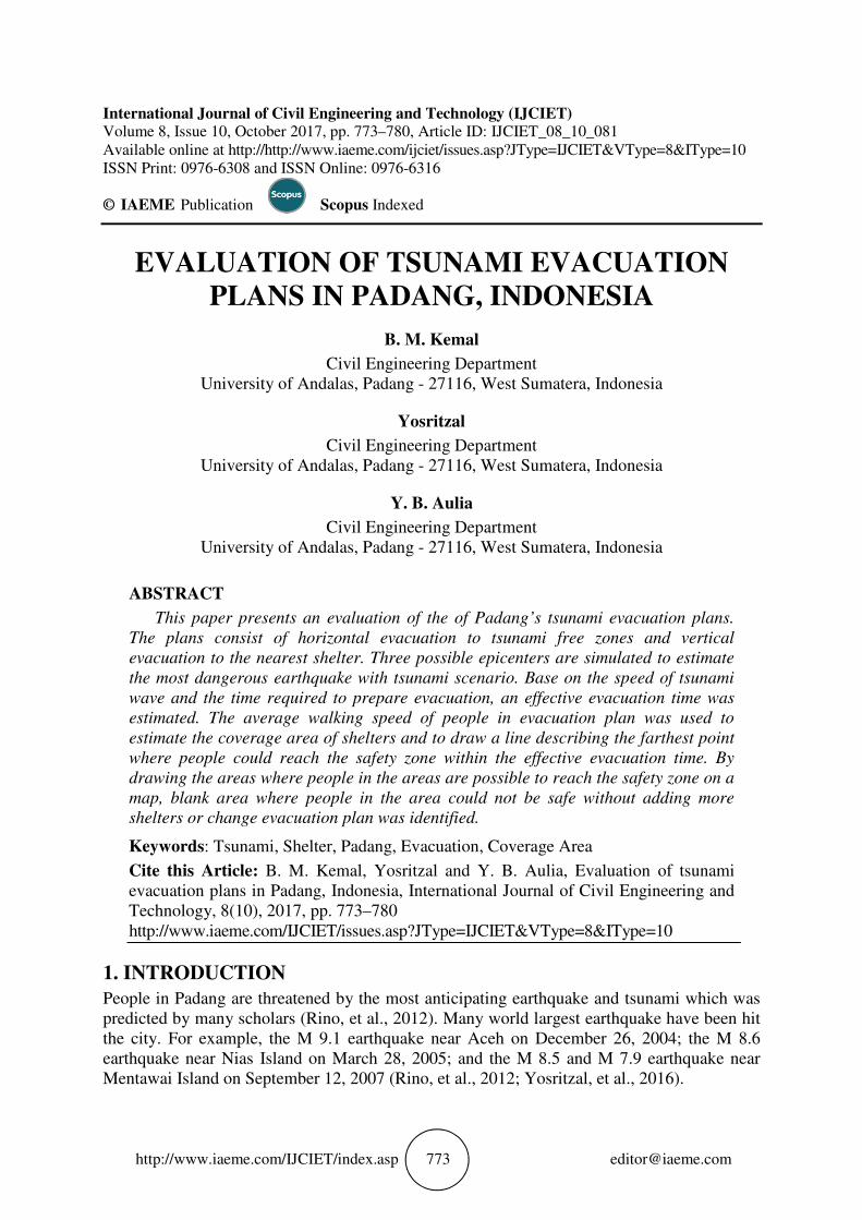
4.2.1. Horizontal Evacuation
Perhaps horizontal evacuation is cheaper than vertical because the infrastructures have already
exist. Therefore, the first scenario is to evacuate all vulnerable people horizontally. First the
safety zone border line was drawn and then a line of 1.37 km the effective evacuation distance
was plotted from the safety zone border to the beach. The area between the lines is the area
where people possible to reach the safety zone within 17.1 minutes’ effective evacuation time.
Figure 2 shows the area.
As shown in Figure 2, the green shading is the area where people possible to reach the
safety zone.
Figure 2 Area for Horizontal Evacuation

Evaluation of tsunami evacuation plans in Padang, Indonesia
http://www.iaeme.com/IJCIET/index.asp 777 [email protected]
Green spots are the location of existing shelters. As shown in the Figure 2, a large part of
Padang specifically the nearest place to the seashore is not shaded. Those people would not
possible to reach the safety zone within 17.1 minutes and therefore horizontal evacuation
alone would not be enough.
4.2.2. Vertical Evacuation
In this scenario, all of the vulnerable people will be evacuate vertically to the nearest shelter.
There are 24 shelters set by authorities in Padang as shown in Table 1.
Table 1 Shelters in Padang in 2015 (source: BPBD Prov. Sumbar, 2016)
No. Name Capacity
1 Masjid Raya Sumatera Barat 4000
2 Masjid NurulIman 2500
3 Masjid Al Muhajirin 4000
4 Masjid Darussalam 5000
5 Masjid NurulHaq 4000
6 Hotel Grand Zuri 3000
7 Hotel Ina Muara 4000
8 Hotel Mercure 3000
9 Hotel Ibis 3000
10 BPK PerwakilanSumbar 2000
11 KanwilDitjenPerbendaharaan Negara 2000
12 Kantor Gubernur 5000
13 Kantor DinasPrasjaltarkimSumbar 5000
14 Kantor BappedaSumbar 2000
15 Gedung DPRD Sumbar 2000
16 Gedung Bank Indonesia 1000
17 GedungFak. Olah Raga UNP 2000
18 Gedungpascasarjana Univ. Bung Hatta 2000
19 GedungKesenian UNP 2000
20 SMK Negeri 5 Padang 3000
21 TK AL Azhar 3000
22 SMP Negeri 25 Padang 3000
23 SMA Negeri 1 Padang 3000
24 SD Negeri 24 Purus 3000
Based on the 17.1 minutes’ effective evacuation time, a shaded area was made around the
shelters.
Yosritzal et al. (2016) designed the coverage area as a circle with radius of 1.37 km and
the shelter as the center without taking street/natural hazard into account. This approach is
reasonable because people should be evacuated within 17.1 minutes time to the nearest
possible safety zone (shelter) even though the shelter is closer to the beach than the location
of the people at that time. People should not be evacuated to a safety zone away from the
beach if the location cannot be reach within 17.1 minutes. However, Yosritzal et al. (2016) yet
to take into account natural hazard such as river and valley or man made hazard such as fence
and building. Therefore, in this presented study, those hazards are taking into account so that
the coverage area would not be a circle but make a shape in response to the the hazard.
Furthermore, when the area coincident with each other, the area will be divided between the

B. M. Kemal, Yosritzal and Y. B. Aulia
http://www.iaeme.com/IJCIET/index.asp 778 [email protected]
shelters. The shaded area is the coverage area of the shelter which shows that people in this
area should be evacuate to the shelter.
Figure 3 shows the coverage area of the shelter with hazard is taking into account. Similar
to the horizontal evacuation, a large part of the seashore area has been covered by the shelters
however, yet a lot more areas have not been covered. So, vertical evacuation alone would also
not enough to safe people.
Figure 3 Coverage area of the shelters
4.2.3. Combo Evacuation
Combo evacuation is a combination of horizontal and vertical evacuation. People who are
possible to reach the safety zone within 17.1 minutes are recommended to do horizontal
evacuation whilst those who are not, are recommended to conduct vertical evacuation to the
nearest shelters. With the effective evacuation time in mind, there will be some people who
can neither reach the safety zone nor shelters. Authorities should provide more shelters for
them. This will be discussed later in another paper.
Figure 4 shows the area coverage by the combo evacuation where people in those area are
possible to reach the shelters or safety zone within the effective evacuation time.

Evaluation of tsunami evacuation plans in Padang, Indonesia
http://www.iaeme.com/IJCIET/index.asp 779 [email protected]
Figure 4 Combo evacuation
The green shaded area is the area of those who possible to reach the safety zone by
horizontal evacuation whilst the area with red boundary is the coverage area of the shelters.
There are some shelters coverage area coincides with the horizontal evacuation which means
those who are in this area have a choice whether to evacuate horizontally or vertically.
However, some areas are not covered by both horizontal and vertical evacuation area. It is
recommended for the authorities to prepare an evacuation plan for them.
5. CONCLUSION
Horizontal and vertical evacuation has been simulated in this study. It is found that the
horizontal evacuation plan alone would not be enough to evacuate people in the vulnerable
areas. Similarly, vertical evacuation to the existing shelters would not be enough as well.
There are a lot of areas not covered by the evacuation plan. Therefore, combo evacuation is
recommended for Padang. Using combo evacuation, the coverage area much larger than the
single evacuation plan.
Even though combo evacuation covers larger areas, some vulnerable areas are still leaving
helpless. Therefore, the authorities are recommended to make an evacuation plan for them
such as build new shelters or reinforced the existing building and use them as temporary
evacuation sites.

B. M. Kemal, Yosritzal and Y. B. Aulia
http://www.iaeme.com/IJCIET/index.asp 780 [email protected]
ACKNOWLEDGEMENTS
We would like to show our gratitude to the Faculty of Engineering - University of Andalas for
their funding support under contract number: 026/UN.16.09.D/PL/2017 and colleagues at
Civil Engineering Department who had provided insight and expertise that greatly assisted the
research.
REFERENCES
[1] BMKG. Sistem Desiminasi InaTEWS. Badan Meteorologi, Klimatologi dan Geofisika,
(Retrieved on 28th August 2015), 2015,
http://inatews.bmkg.go.id/new/about_inatews.php?urt=13.
[2] BNPB. Buku Saku Tanggap Tangkas Tangguh Menghadapi Bencana, Badan Nasional
Penanggulangan Bencana (BNPB), Jakarta, 2012
[3] BPBD Prov. Sumbar. Shelter di Kota Padang dan Pesisir Selatan. Retrieved at 4th
September 2016, from url: http://bpbd.sumbarprov.go.id/details/news.
[4] Borero, J.C., Sieh, K., Chileh, M. and Synolakis, Tsunami Inundation Modeling for
Western Sumatera, Proceeding of the National Academy of Sciences of the United Stated
of America, Vol. 103 No. 52. 2006, Pages 19673-19677.
[5] Folger T. (2014) Will Indonesia Be Ready for the Next Tsunami? Retrivied from
http://news.nationalgeographic.com/news/2014/12/141226-tsunami-indonesia-
catastrophe-banda-aceh-warning-science/ accessed on 2nd May 2017.
[6] Gunawan, M. T. EarthquakePotential Near Sumatera Island, Workshop for Preparing for
Conducting an Earthquake Simulation, BMKG, Gladi Posko BNPB, Padang, 2011.
[7] Pond, S. and Pickard, G.L. Introductory Dynamical Oceanography, 2nd edition, London,
Butterworth Heinemann, 1983.
[8] Puspito, N.T. and Triyoso, W.,. Aspek kegempaan Tsunami di Indonesia, Suatu Tinjauan
Awal, Seminar Sehari Masalah Tsunami di Indonesia dan aspek-aspeknya. Bandung,
1994, pp. 128-150.
[9] Putra, A. P. Penataan Ruang Berbasis Mitigasi Bencana Kabupaten Kepulauan
Mentawai.Jurnal Penanggulangan Bencana, BNPB, Volume 2 No. 1, 2011, p. 11-20
[10] Rienne, T., Tillander, K., and Gronberg, P.. Data Collection and Analysis of Evacuation
Situations. ESPOO 2010. VTT Tiedotteita – Research Notes 2562, 2010, 46 p. + app. 92
p.
[11] Rino, Meilano, I., Gumilar, I., and Hilman, D.H (2012) Tectonic Strain in Sumatera Based
on Continuous Sumatran GPS Array (SuGAr) Observation 2007-2008., Indonesian
Journal of Geospatial, Vol. 2, No. 1, 2012.
[12] Tanioka, K. and Satake, K. Tsunami Generation by Horizontal Displacement of Ocean
Bottom, Geophysical Research Letters, Volume 23, Issue 8, 15 April 1996. Pages 861–
864.
[13] Yosritzal, Badrul Mustafa Kemal, and Firmana Siddik (2016) Estimation of coverage area
of tsunami shelters in Padang. Proceeding of National Conference of Applied Sciences,
Engineering, Business and Information Technology. Politeknik Negeri Padang, 15-16
Oktober 2016.
[14] Md Mostafizur Rahman and Eizo Nakaza, Experimental and Numerical Simulation of
Tsunami Bore Impact on a Building. International Journal of Civil Engineering and
Technology, 7(4), 2016, pp.13–23.
[15] Kent Inagaki, Eizo Nakaza, Carolyn Schaab and Satoshi Tanaka, Distribution
Characteristics of Pine Trees along the Coast of Sendai City Swept away by the 2011
Tohoku Region Tsunami. International Journal of Civil Engineering and Technology,
7(6), 2016, pp.434– 443.