Embed Size (px)
Citation preview

EVALUATING LEARNING MATERIAL FOR MAP READING
Lorraine Innes, Chief Directorate, Surveys and Mapping, Department of LandAffairs, Republic of South Africa
ABSTRACT
In 1997 the South African national mapping organisation (the Chief Directorate:Surveys and Mapping) launched a national campaign to promote mapawareness and map literacy. One product of the MapAware Project is MapTrix:a self-instruction programme for learning to read the 1:50 000 Topographic Mapof South Africa. The National Department of Land Affairs, through the nationalmapping organisation, sponsored two thousand MapTrix Kits for under-resourced schools throughout South Africa. At the nine provincial MapTrixpresentation ceremonies, geography education authorities were requested toallocate donated Kits to those schools most in need of learning materials formap use. The names and contact details of these schools were requested sothat placement and adoption of the materials could be investigated. A survey ofgeography educators’ opinions was conducted by means of a postalquestionnaire. Biographical details of educators revealed their level of trainingfor teaching map use and the resources available to them for performing thistask. The evaluation of all aspects of the learning material and of the attitudeand behaviour of educators and learners while using MapTrix is reported. Thequestionnaire included an invitation to collaborate in the further development ofthe learning material for the higher order skills of map and photo analysis andinterpretation. The response of the educators is described.
KEY WORDS: topographic map reading, spatial skills, evaluation of learningmaterials, self-instruction, attitude scale.
BACKGROUND
Visionary planning initiated in 1995 eventually led to the appointment of a full-timegeographer and short-term consultant on 1 June 1997 to develop a Map Awarenessand Map Literacy Project for the South African national mapping organisation.Charged with this responsibility is the Chief Directorate of Surveys and Mapping(CDSM) in the Department of Land Affairs (DLA) (Hanekom, 1998).
The MapAware Project addresses the problem of low levels of map literacy in SouthAfrica (Innes 1999a). This is evidenced by poor performance in school leavers’geography practical examinations (Magi, 1981; Davies, 1988; Burton, 1990;Ndlwana, 1991; Cowie, 1994; McGee et al., 1995; Sekete, 1995; Tshibalo andSchulze, 2000) and the low ratio of maps sold, per head of population (Clarke,1997). CDSM undertook to provide maps to schools (Clarke, 1996) and the processwas formalised with an undertaking to put the local topographic map sheet on thewall of every senior secondary geography classroom in South Africa (Innes, 1997).Apart from five free maps, MapPacks include information to help educators use themaps in geography education; activities that develop environmental responsibility areencouraged (Naisch et al., 1979; Innes, 1999b and 1999c). Other MapAware

teaching aids include the MapAware Test Map, Gordon’s Bay Training Map (withaccompanying co-ordinate exercise) and the MapAware Symbols Video. Staff of theMapAware project assist educators to access appropriate spatial informationproducts from the National Map Series and process the 33 % discount (GovernmentGazette, 2001) offered to approved educational institutions that promote map usethrough geography and/or environmental education.
Much of the research that informed the products and processes of the MapAwareProject was conducted during the development of MapTrix: a self-instructionprogramme for learning to read the 1:50 000 Topographic Map of South Africa(Innes, 1998 & 2000a). A Kit contains all the material required to administer theMapTrix programme. The main component is a set of 52 work cards, each has ageography lesson with accompanying map extract, a map reading exercise andselected symbol explanations illustrated by colour photographs. Also included are52 answer cards, learner response booklets and the MapTrix Educator’s Guide.
MapTrix was launched in October 2000 at the 80th anniversary celebrations ofCDSM. Minister of Education, Professor Kader Asmal, accepted a donation from theDLA of two thousand Kits on behalf of schools teaching geography to Grade 12(Tickner, 2000). Of these, 200 Kits were made available to schools as prizes in acompetition run by The Teacher (2001). One thousand eight hundred Kits werepresented to provincial education authorities during February and March 2001. Theywere asked to allocate Kits to those schools most in need of materials to improveperformance in the practical examination for Grade 12 geography. A further 1000Kits were published for commercial distribution.
In order to assist educators in the implementation of the learning programme, atraining video was produced (Chief Directorate: Surveys and Mapping, 2000b). Atthe nine presentation ceremonies, attended by provincial education authoritiesresponsible for geography, the video was shown and its use in teacher trainingrecommended. Authorities were requested to provide CDSM with the name andaddress of each school allocated a MapTrix Kit. This information was required tosurvey educators’ and learners’ opinions of MapTrix and to invite educators tocollaborate in the development of further learning materials (Innes, 2000b & 2001).
LEARNER SUPPORT MATERIAL FOR MAP READING IN SOUTH AFRICA
Map reading can be defined as “the recognition and identification of map symbolsand the comprehension of the geographic features that they represent” (Innes1998, 1). This is the basic skill level in a hierarchy that includes the analysis andultimately the interpretation of spatial information. The 1:50 000 topographic map ofSouth Africa is the base map of the national map series. Its study is prescribed forthe practical matric (Grade 12) geography paper. This map (on 1916 sheets) is thusthe focus of learning materials developed by the national mapping organisation andmade available to formal and informal education so as to promote and improve mapliteracy (Innes and Engel, 2001a & 2001b). Guidance from education departments(e.g. Smit, 1994) as well as general geography school texts and specific texts formap use (from Liebenberg et al 1976 to Burton and Pitt, 1993 to name a few) all usemaps from this series.

Research revealed that maps were generally not available in all schools and thatmany geography educators had received inadequate training (Magi, 1981; McGee etal., 1995; Sekete, 1995). This motivated the development of a self-instructionprogramme so that maps, lessons and exercises could be delivered directly into thehands of geography learners (Innes, 1999d). It is recognised that higher order mapuse skills also need to be developed. It is proposed that a self-instruction method foranalysing and interpreting spatial information, provisionally named MapTrix 2, shouldbe developed as a companion to MapTrix but first it is necessary to evaluate theexisting programme. This paper is a report on the evaluation of MapTrix as a meansto improve the map reading ability of learners in under-resourced classrooms inSouth Africa.
QUESTIONNAIRE SURVEY
The evaluation of the learning material was conducted using a postal questionnairesurvey. Following the guidelines of Bless and Higson-Smith (1995) a draftquestionnaire was drawn up covering various issues: the practical (access to thematerials), demographic (educator and learner profiles), behavioural (tasks andperformance) and attitudinal or perceptual (positive or negative impact or response).Because attitude to an innovative educational intervention strategy is likely toinfluence adoption rates, it was decided to incorporate attitude scales into the surveyquestionnaire. These were included so as to produce a measurable attitude ‘score’and to identify particular strengths and weaknesses in the programme and learningmaterials.
Huysamen (1994) reviews the attitude scales developed by Likert, Guttman andothers but cautions that researchers need to “compile attitude scales themselves tomeasure the attitudes relevant to their research” Huysamen (1994, 125). The aspectof the Guttman scale adapted for the attitude scales used in the evaluation ofMapTrix was the simple yes/no response style. This was selected in preference tothe degree of agreement or disagreement (on a scale of 5) used by Lickert. Boththese scales use a variety of statements graded from most to least favourable.Rather than impersonal statements, a series of questions was asked about theparticipants’ personal experience of using MapTrix. The score is simply the numberof statements with which the participant has agreed. Instructions were kept to aminimum and the responses were largely confined to a yes or no response.
Two attitude scales were developed, one to assess the educators’ evaluation oflearner attitudes and behaviour and the other to assess the educators’ evaluation oftheir own response to the MapTrix programme and procedures. Each consisted oftwenty questions to which a yes or no answer was required. The order of yes/noresponses was varied to “counteract the possible effect of acquiescence”(Huysamen, 1994, 129). Participants could also opt not to answer at all or to returna not applicable (n/a) response. Because the scale was developed to evaluatewhether educators (and learners) were positively disposed towards MapTrix, positiveresponses were allocated a value of 1, all other responses a zero value.
A pilot survey was conducted with six educators at schools in the local area(Western Cape). The schools selected ranged from extremely well resourced to onewith minimal resources. Structured face-to-face interviews were conducted with

three educators; structured telephone interviews were conducted with the others whohad each received the draft questionnaire for close scrutiny beforehand. Allparticipants were asked to comment on the clarity of the questions and theirsuggestions were later incorporated into the final document. An educator from anunder-resourced school advised that questionnaires should be addressed to theschool principals, not senior geography educators. He intimated that, because of thestrict hierarchical authority structure in many schools, unless a task was assigned bythe principal it would not be undertaken. (The efficacy of this suggestion is disputedin the light of the fact that 1200 questionnaires have not been returned.)
The structure of the final questionnaire is summarised in Table 1 below. It consistedof four A4 pages but the majority of answers required only a tick (¸ or ˚). Thefigures in brackets indicate the number of answers that could be eliminated asoptions, depending on prior responses (e.g. If your answer is NO, please explain).
TABLE 1: MAPTRIX QUESTIONNAIRE: ANALYSIS OF QUESTION TYPE ANDNUMBER
SectionTicked
responses1 or 2
words ornumbers
Comments(phrases,
sentences)A. Access to MapTrix and personaldetails of educator
17 (10) 2 (1) 2
B. Educator’s evaluation of attitudeand behaviour of learners
20 3 (3) 4
C. Further development of the MapTrixlearning programme
4
D. Educator’s evaluation of theMapTrix programme and procedures
28 (3) 8 2 (2)
E. Educator’s evaluation of existingMapTrix components
10 4 (4) 2 (2)
Totals 79 (13) 17 (8) 10 (4)
Educators at the 2000 schools that received donated MapTrix Kits were theproposed target population for the survey. Apart from the 200 competition winners ofwhich the school names and addresses were known, 1399 school names weresupplied by provincial education authorities. Only 230 of the names were suppliedwith postal addresses but many missing addresses were traced in the EducationManagement Information System (EMIS). Unfortunately 156 school names couldnot be matched with those in the database. A total of 58 duplicate names werefound (25 of which were in the Eastern Cape). It was later discovered that some ofthe names supplied were those of schools for which education authorities hadpurchased Kits. Twenty percent of the donated MapTrix Kits remain unaccountedfor, because the details of recipient schools have not been supplied.
Approximately one year after delivery of the learning materials to the provinces, 1410questionnaires to survey educator and learner opinions of MapTrix were posted outbetween January and March 2002. Each envelope also contained a brochuredescribing all the products and services of the MapAware Project (including theMapTrix Kit and Training Video). Of those despatched, the post office returned 32because the addresses were incorrect or post boxes were no longer operative. This

reduced the potential respondents to 1378. A total of 178 educators (12,9%)eventually responded. Only 97 had responded by the original deadline date, whichwas extended by three months. An appeal to national and provincial educationauthorities for assistance led to some geography learning facilitators (subjectadvisors) requesting the return of questionnaires to their district offices. These werethen submitted in batches, the latest arriving late in July.
It was distressing to discover that 55 educators (30,9 %) indicated that their schoolshad not received the MapTrix Kits that had been allocated to them by their provincialeducation authorities. 31 respondents (17.4 %) had received the Kits but had eithernot used them yet or completed too few of the questions to effectively evaluate thelearning materials. Responses showed that MapTrix Kits had been at their schoolsfor between one and 18 months, averaging 8.6 months. A total of 92 respondents(51,7%) had received the Kits, had used them and were thus able to complete thequestionnaire to evaluate MapTrix.
Before reporting on the evaluation of MapTrix, and whether it is useful in improvingmap use skills in under-resourced geography classrooms, the conditions for effectivemap use education in those classrooms are investigated.
Access to resources and training for teaching map use
In section A of the questionnaire, access to learning materials, teaching aids andeducator training were evaluated. Most of the questions in this section were of ageneral nature and could be answered by all 178 educators who responded whetherthey had received a MapTrix Kit or not. Many participants left spaces blank so onlyticked answers and written responses were analysed. Here, as elsewhere in thereport, no answers were assumed to be either positive or negative by default.
In response to the question on MapTrix information and/or training received prior toarrival of the questionnaire, 13 educators had seen the article (and competition)published in The Teacher (2001), 48 had received information via their subjectadvisors of which 36 had attended workshops. Only 10 had seen the MapTrix Videoand 21 had found out about the Kit from information in the MapAware Brochure.Many of the educators had acquired their information from more than one of theabove sources, four had found out about MapTrix elsewhere. 83 respondents(46.6 %) had received no prior information about MapTrix before the questionnaire orthe Kit arrived at their schools. The survey revealed that once the Kit and/or thequestionnaire had arrived, 105 (59 %) shared the information with fellow geographyteachers.
Geography teaching experience of respondents ranged from 1 year (or less) to 30years with a mean of 9.8 years. 112 educators (62.9 %) felt that they had beenadequately prepared to teach map use but only 100 (56.2 %) indicated that theycurrently felt confident of their map use skills. While 6 (3.4 %) believed that usingMapTrix could not improve their skills and 11 (6.2 %) were undecided, 161 (90.4 %)of the educators who responded believed that using MapTrix could lead to animprovement in their own map use skills. This was the first indication of a positiveattitude towards the learning programme.

With regard to resources available at their schools, 135 (75.8 %) educators felt thatthese were not adequate for the general needs of their schools and 139 (78.1 %)indicated that their geography resources were inadequate. Of the latter group 84 %(117 of 139) took the trouble to comment on the resources not available to them forteaching map use to their geography classes. As with the analysis of all commentssolicited in the survey, words or phrases were noted as they appeared, repeatincidents were recorded then similarities were grouped into categories.
The plight of 23 of the 117 educators who commented (19.6 %) appeared quitedesperate. Of these, 15 stated that they require ‘everything’ or ‘anything to help us’and 8 indicated the need for an equipped geography classroom. In most cases,however, educators were less vague about the specific items they required. In Table2 the requested items are listed and ranked according to most urgent need.
TABLE 2: RESOURCES FOR TEACHING MAP USE THAT ARE NEEDED BYPARTICIPATING EDUCATORS
General 38Topographic maps 40Local topographicmap sheets
23Maps
Aerial photographsand/or orthophotomaps
18
119
Globes 18Compasses 6Stereoscopes 12Opisometers 4Mathematicalequipment
6
Special equipment
3D models 5
51
Overhead projector 5Transparencies 1Television andvideo machine
14
Videos 10Computers 2Slide Projector 1
Electronicequipment and
accessories
Light table 1
34
Text books 11Atlases 5TextsSundries(exercises, syllabusetc)
4 20
Workshops on mapuse
6Training and/orassistance
Senior/ additionaleducator
2
8

MapTrix Kits were identified as necessary resources by 20 educators, some becausethey had not received their allocated Kits and others needed more Kits because onewas not enough. Of the 178 educators who responded 26 (16.3 %) indicated thatthey had adequate resources and no needs. The resources available to the othersare summarised in Table 3. Of the 77 times that maps are mentioned, the suppliesare adequate for class numbers in only 28 cases.
TABLE 3: RESOURCES FOR TEACHING MAP USE THAT ARE AVAILABLE TOPARTICIPATING EDUCATORS
Overhead projector 1Electronicequipment and
accessoriesVideos 2
3
globes 9stereoscopes 3Special equipmentmathematicalequipment
214
Text books 14atlases 5Textssundries(exercises, syllabusetc)
221
General• some• enough
3228
Maps
Topographic maps,aerial photographsand/or orthophotomaps (from pastexams)
17
77
The majority of schools responding to the survey are clearly under-resourced. Thiscan be confirmed by two facts (above all else): only 56.2 % of the 178 seniorgeography educators surveyed are confident of their own map use skills (90.4 %believe these can be improved by a basic map reading programme) and 78 % lackadequate resources for teaching map use.
Evaluation of MapTrix
Data from the 92 questionnaires that provided a full evaluation (more than threequarters of the answers completed) is included in the discussion that follows.Because class numbers have an impact on the administration and efficacy ofMapTrix these are described first. The evaluation then considers three yardsticks.(i) Items in the attitude scales are evaluated individually to identify strengths andweaknesses. (ii) The educators’ scores for learners’ and their own attitudes arerecorded and analysed. (iii) The answers to the open-ended questions areevaluated to identify those aspects that educators found most and least favourable.The measures are compared with each other where relevant.

Class sizes and grades
MapTrix was designed for use by one to a maximum of 40 learners in Grade 10working simultaneously. The data from Section D indicated that 92 educatorsevaluated MapTrix with an estimated 10 311 learners in 296 classes of greatlyvarying size, ranging in level from Grade 8 to Grade 12. (Some educators gave thetotal number of learners and the total number of classes; in such cases the learnerswere divided equally between classes. In other cases educators gave mean classsizes.) On average each educator was responsible for teaching map reading to 112learners. The breakdown of learner numbers is presented in Table 4. In most casesmaximum class sizes were far larger than the capacity of the programme.
TABLE 4: RANGE AND SIZE OF CLASSES THAT USED MAPTRIXGrade 8 9 10 11 12 Total
Learners (total) 337 546 2744 3337 3347 10 311Classes (total) 10 16 73 92 105 296Average number oflearners per class
33.7 34.13 37.59 36.27 31.88 34.83
Maximum 40 48 102 84 62 102Minimum 29 20 13 14 5 5Times grade wasrecommended byeducators for usingMapTrix
9 15 57 54 52
Educators’ perceptions of learner attitude and behaviour
The first of the attitude scales, constructed to elicit 20 possible ticked responses,was included in Section B. Of these responses, 7 were related to learner attitudeand 13 to their behaviour. YES answers to half the questions added a positive scorewhile NO replies to the other half indicated a positive evaluation. Theoretically, toelicit a maximum positive attitude score of 20 points, educators would agree with allthe questions worded to elicit a positive response (e.g. when evaluating learnerattitude ‘did the majority of learners like to mark their own answers?’ -YES) anddisagree with all those worded negatively (e.g. when evaluating learner behaviour‘did the majority of learners have difficulty finding the correct answers on the maps?’- NO). The twenty items and preferred replies are listed in Tables 5a and 5b with thenumber (and percentage) of educators that selected them.
TABLE 5A: ITEMS USED TO TEST EDUCATORS’ PERCEPTIONS OF LEARNERATTITUDES TO MAPTRIXNo. Question Repl
yTot
al%
B. 1. In your experience of using MapTrix did the majority of learnersb. • like to mark their own answers? YES 82 89.0c. • fail to understand at least 8 of the 10 questions in
each exercise?NO 65 70.3
k. • enjoy the MapTrix learning periods? YES 88 95.2B. 2. In your experience of using MapTrix as a teaching aid, did the above
average learners
a. • become bored because they found MapTrix tooeasy?
NO 77 83.3
b. • willingly play the role of peer tutor to assist theirclassmates?
YES 78 84.3
B. 3. In your experience of using MapTrix as a teaching aid, did the belowaverage learners
a. • become frustrated and therefore fail to completethe programme because they found MapTrix toodifficult?
NO 68 73.9
b. • feel encouraged by their improvement due torepeated practice?
YES 77 83.3
TABLE 5B: ITEMS USED TO TEST EDUCATORS’ PERCEPTIONS OF LEARNERBEHAVIOUR WHILE USING MAPTRIXNo. Question Repl
yTot
al%
B. 1. In your experience of using MapTrix as a teaching aid, did the majority oflearners
a. • find the procedure very complex and keep askingquestions?
NO 48 52.1
d. • efficiently and independently follow the self-instruction procedure once they got used to it?
YES 76 82.6
e. • have difficulty finding the correct answers on themaps?
NO 64 69.6
f. • search through all the information (lessons andillustrations) for answers?
YES 68 73.9
g. • usually guess the answers without looking at theavailable information?
NO 61 66.3
h. • have difficulty using the playing card symbols tofind the correct answer cards to match their workcards?
NO 73 79.3
i. • always mark their own work strictly according to theanswer cards?
YES 70 76.1
j. • correctly fill in the bar graphs to monitor their ownprogress?
YES 55 59.8
l. • fail to complete the programme in the 12 learningperiods recommended?
NO 45 48.9
B. 2. In your experience of using MapTrix as a teaching aid, did the aboveaverage learners
c. • need to complete only 12 - 16 exercises in order tomaster all four themes?
YES 53 57.6
d. • take 12 periods or more to finish the programme? NO 25 27.2B. 3. In your experience of using MapTrix as a teaching aid, did the below
average learnersc. • take much longer than 12 periods to complete the
programme?NO 33 35.9
d. • eventually master all four themes? YES 50 54.3

The majority of educators rated learner attitude to MapTrix very highly (Table 5a)with 95.2 % indicating that the majority of learners enjoyed the MapTrix periods,especially marking their own answers (89 %). Educators’ perceptions of learnerbehaviour (Table 5b) generally scored lower than attitude. However, 82.6% of theeducators indicated that the majority of learners efficiently and independentlyfollowed the self-instruction procedure once they got used to it, easily found theanswer cards to match their work cards (79.3 %) and then marked their answersstrictly according to the answers provided (76.1 %).
The items that scored the lowest were all related to the time factor. The 12 learningperiods envisaged for the programme appear to be too few. The average length ofgeography learning periods (as indicated by responses to Question 5 in Section D)was 44 minutes ranging from 30 minutes to a maximum of 60 minutes. Because ofthis range it is difficult to quantify the average time taken to complete the programmebut learners of all ability levels generally took longer than anticipated.
In response to the question ‘did the majority of learners fail to complete theprogramme in the 12 learning periods recommended’, 6 educators did not answer,41 answered YES and less than half (48.9 %) answered NO. The lowest score wasattained for the item ‘did the above average learners take 12 periods or more tofinish the programme?’ The preferred answer was NO but only 27.2 % of educatorsagreed; 55 educators answered YES and 12 did not answer. 50 educators indicatedthat below average learners were taking longer, some up to 30 periods. Although inmost cases educators indicated that below average learners eventually completedthe programme they were reluctant to indicate that learners attained mastery. Manyeducators (18) failed to answer the question ‘did below average learners eventuallymaster all four themes’, 24 answered NO leaving only 54.3 % who answered YES.The fact that many class sizes were far larger than recommended probably lead toindividuals having to wait for required work cards, protracting the time unnecessarilyand possibly contributing to the low completion rate.
In Appendix A, the number codes allocated to schools are listed with educators’attitude scores as well as the mean, median and mode of the data. Numbers wereallocated to school names listed alphabetically per province. Questionnairesreturned anonymously were numbered from 3000 onwards as they were received.Table 6 shows a breakdown of scores categorised according to frequency.
TABLE 6: EDUCATORS’ RATING SCORES FOR LEARNER ATTITUDE ANDBEHAVIOUR WHILE USING MAPTRIXScore Attitude category Number of
educators%
0 – 10 Negative 14 15.211 – 14 Positive 31 33.715 – 17 Very positive 37 40.218 - 20 Strongly positive 10 10.9
Total 92 100
The majority of educators (78, 84.8 %) rated learner attitude and behaviour positivelyof which 37 (40,2 %) were very positive and 10 (10,9 %) were strongly positive. Toillustrate the rating score, an evaluation of educators’ comments was also

undertaken. In Table 7 educators’ perceptions are categorised according to thelearners’ favourite components (the full colour symbol illustrations and maps),aspects of the self-instruction methodology (it’s easy/like playing) and the activities(the opportunity to practice).
Although some educators neglected to fill in comments on either learner likes ordislikes, many listed likes but left the dislikes space blank. In 33 cases theyindicated that learners disliked nothing (or liked everything). In no case were onlylearner dislikes recorded. In Table 8 learner dislikes are summarised, the first threecategories can all be linked to the language of instruction. The third item in Table 8‘takes too long, too much reading’ may help to explain the time problem.
TABLE 7: EDUCATORS’ PERCEPTIONS OF WHAT LEARNERS LIKED MOSTABOUT MAPTRIX
Aspect of the MapTrix programmeNumber oftimes cited(out of 102)
Pictures/illustrations,information/explanations of symbols
24
Maps (full colour, ‘reality’) 13Geography lessons 3Getting to know different places 3
Components learners likedhaving
Grid reference/lines 2• because it’s easy/like playing 16• independently, at their own pace 6• in groups 5
Methodology: learnersliked working
• in competition with each other 1Practising, revising, getting to knowquestion styles
14
Searching for interesting/new things 5Marking their answers 6Recording progress (seeingimprovement)
3
Activities learners likeddoing
Competing with others 1
TABLE 8: EDUCATORS’ PERCEPTIONS OF WHAT LEARNERS LIKED LEASTABOUT MAPTRIX
Aspect of the MapTrix programmeNumber oftimes cited(out of 25)
Not in mother tongue 9Tricky questions 6Takes too long, too much reading 4Repetitive, level does not varyNot enough calculations
3
Symbols too smallDrawing bar graphsNot enough work cards
2
Not enough games, no orthophoto maps, too many calculations, nolocal area maps, hard to find answers
1 each
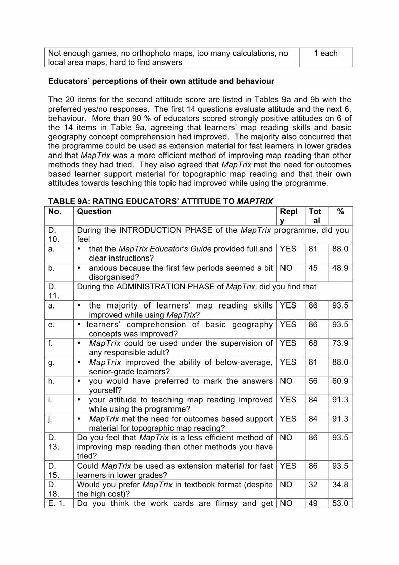
Educators’ perceptions of their own attitude and behaviour
The 20 items for the second attitude score are listed in Tables 9a and 9b with thepreferred yes/no responses. The first 14 questions evaluate attitude and the next 6,behaviour. More than 90 % of educators scored strongly positive attitudes on 6 ofthe 14 items in Table 9a, agreeing that learners’ map reading skills and basicgeography concept comprehension had improved. The majority also concurred thatthe programme could be used as extension material for fast learners in lower gradesand that MapTrix was a more efficient method of improving map reading than othermethods they had tried. They also agreed that MapTrix met the need for outcomesbased learner support material for topographic map reading and that their ownattitudes towards teaching this topic had improved while using the programme.
TABLE 9A: RATING EDUCATORS’ ATTITUDE TO MAPTRIXNo. Question Repl
yTot
al%
D.10.
During the INTRODUCTION PHASE of the MapTrix programme, did youfeel
a. • that the MapTrix Educator’s Guide provided full andclear instructions?
YES 81 88.0
b. • anxious because the first few periods seemed a bitdisorganised?
NO 45 48.9
D.11.
During the ADMINISTRATION PHASE of MapTrix, did you find that
a. • the majority of learners’ map reading skillsimproved while using MapTrix?
YES 86 93.5
e. • learners’ comprehension of basic geographyconcepts was improved?
YES 86 93.5
f. • MapTrix could be used under the supervision ofany responsible adult?
YES 68 73.9
g. • MapTrix improved the ability of below-average,senior-grade learners?
YES 81 88.0
h. • you would have preferred to mark the answersyourself?
NO 56 60.9
i. • your attitude to teaching map reading improvedwhile using the programme?
YES 84 91.3
j. • MapTrix met the need for outcomes based supportmaterial for topographic map reading?
YES 84 91.3
D.13.
Do you feel that MapTrix is a less efficient method ofimproving map reading than other methods you havetried?
NO 86 93.5
D.15.
Could MapTrix be used as extension material for fastlearners in lower grades?
YES 86 93.5
D.18.
Would you prefer MapTrix in textbook format (despitethe high cost)?
NO 32 34.8
E. 1. Do you think the work cards are flimsy and getdamaged too easily?
NO 49 53.0

damaged too easily?E. 3. Are there too few work cards in the Kit to keep all the
learners in the class busy?NO 41 44.6
TABLE 9B: RATING EDUCATORS’ BEHAVIOUR IN RESPONSE TO USINGMAPTRIXNo. Question Repl
yTot
al%
D.11.
During the ADMINISTRATION PHASE of MapTrix, did you find that
b. • you were too busy with administration to help yourbelow-average learners?
NO 49 53.0
d. • you had to impose discipline in the classroom moreoften than usual?
NO 63 68.5
D.12.
If you continue to teach geography, will you useMapTrix with your classes again?
YES 89 96.7
D.14.
Will you discourage other geography educators fromusing MapTrix?
NO 86 93.5
D.16.
Would you recommend that your school purchasemore MapTrix Kits?
YES 79 85.9
D.17.
If you use MapTrix in the future, will you administer theprogramme and procedures differently from thosesuggested?
NO 71 77.2
Despite their favourable responses (Table 9a & 9b) and comments (Table 11), themajority of educators (57, 62 %) would prefer the programme in textbook format.Just over half (47, 51 %) indicated that there were too few cards to keep all learnersbusy. Despite the fact that 88.0 % felt that the MapTrix Educator’s Guide providedfull and clear instructions, 48.9 % felt anxious because the first few periods seemeda bit disorganised. Both these factors are influenced by the fact that there weremore learners in the class than MapTrix was designed to accommodate. The itemon which there was the highest degree of concurrence (96.7 %) in Table 9b was thateducators would use MapTrix again; 93.5 % indicated that they would not discourageother educators from using the programme. All scores in this section were positive,the lowest (53.0 %) expressing a concern that educators were too busyadministering the programme to help below-average learners (again theconsequence of large numbers).
In Appendix B the scores attained by responding educators are listed, these reflecttheir attitudes to MapTrix and are summarised in Table 10. It is interesting thateducators rate their own attitude and behaviour when using MapTrix more favourablythan that of their learners. 89 or 96.7 % viewed the programme in a positive lightwith 42 (45.6 %) very positive and 18 (19.6 %) strongly positive. Only 3 (3.3 %) werenegative.
TABLE 10: EDUCATORS’ RATING SCORES OF THEIR OWN RESPONSE TOUSING MAPTRIXScore Attitude category Number of
educators%
0 – 10 Negative 3 3.3

11 – 14 Positive 29 31.515 – 17 Very positive 42 45.618 – 20 Strongly positive 18 19.6
Total 92 100
To illustrate the statistics, educators were asked to comment on the mainadvantages and disadvantages of using the self-instruction method. In Table 11 atotal of 83 positive comments are recorded. (It appears that some educatorsmisunderstood the question because many comments related specifically toMapTrix; these have not been discussed here.) Although they had scored learnerattitude and behaviour lower than their own, most educators commented on benefitsto the learners; they identified very few advantages for themselves. The exceptionswere the four educators who observed that their evaluation of learner performancewas made easier and the three who indicated that they got more work done in lesstime. The advantages to learners regarding working independently and improvedskills and understanding, reflect the findings in the analysis of the attitude scaleitems.
TABLE 11: ADVANTAGES OF SELF-INSTRUCTION IDENTIFIED BYPARTICIPATING EDUCATORS
Aspect of self-instructionNumber oftimes cited(out of 83)
Learner independence (including: self-motivated, active participation,discovery, enquiry and synonymous phrases)
29
Improved understanding of learners (including: confidence, skills,practical ability and synonymous phrases)
16
Learners work at their own pace 10Group work, assisting each otherAware of progress (they can identify and correct problems)
7
Learner enjoymentEvaluation is easy (because learners mark their own work)
4
More work done in less time 3General comments: syllabus related, language improvement, equalopportunity for all learners
1 each
In all cases where educators made comments, none entered only disadvantages. Inmany cases where advantages had been mentioned, the disadvantage space hadbeen left blank while 26 educators entered ‘none’, ‘nothing’ or ‘n/a’. Table 12 lists 38identified disadvantages, the majority (11) indicate that self-instruction was too timeconsuming. This can be expected in classes of many more than 40 learners. It wasdisappointing to note that dishonesty of learners was a concern for ten educators.The disadvantage of the learning materials not being in their learners’ mother tonguewas a specific problem for nine.
TABLE 12: DISADVANTAGES OF SELF-INSTRUCTION IDENTIFIED BYPARTICIPATING EDUCATORS
Aspect of self-instructionNumber oftimes cited

(out of 38)Time consuming 11Dishonesty (cheating, copying) 10Unfamiliar English words 9Slow, lazy learners do not work 5Don’t follow instructions (can’t do self instruction) 4Learners are discouraged by difficulties/mistakes 3General comments: shy learners held others up, don’t know if theygrasp it, too much information, can’t help slow learners
1 each
Evaluation of MapTrix components
Only 41 educators (44.6 %) agreed that there were enough work cards in the Kitwhile only 49 educators (53.3 %) felt that the cards were sturdy enough. Fewereducators (23, 25 %) felt there were not enough work cards on each topic, somesuggesting that more should be included for landscape. Concurring with the positivecomments of learners about the full colour symbol illustrations, 84 educators (91 %)agreed that these helped learners understand the map symbols. The majority ofeducators (81, 88 %) felt that the lessons were clear and easy to understand.
General format of the MapTrix Kit and programme
Although the majority of educators evidenced a positive attitude to the programme itwas surprising to find that 57 (58.7 %) indicated that they would prefer MapTrix intextbook format. Of those who preferred this option, 48 educators (52.1 %) indicatedthat they would like to use this format themselves and with their classes while 5would like MapTrix ‘textbooks’ for themselves only.
A small number (3) felt that the self-instruction method was less efficient than theirpreferred methodologies which one indicated as the ‘demonstration’ method, theother two did not comment. 15 educators indicated that they would administer theprogramme differently from that suggested of which 10 offered some alternatives.Four would prefer to integrate the MapTrix exercises with their own learningprogrammes when they deal with the geography lesson topics separately while onefelt that all the map skills should be integrated when using each map. Two felt thatthey would have to work harder if they used the programme again, one realising thatlearners could not be left ‘to practice on their own’ and the other indicated that moreactive participation was required ‘to enhance learning and teaching’. One wouldprefer to use videos, another to have a copy of the Kit exclusively for their own use.One educator indicated that they would have preferred to mark all the answers.
LANGUAGE OF LEARNING MATERIALS
The last item in the questionnaire enquired whether some or all of MapTrix should betranslated from English into another language and if so what language that shouldbe. This is of great relevance in a multi-lingual country such as South Africa, whichnow recognises eleven official languages. (Prior to 1994 English and Afrikaans, bothspoken by the white minority, were the only official languages). Table 13 gives abreakdown of the languages spoken at home by learners, used for teaching and

selected for examination. It also indicates the educators’ selections of translationoptions.
TABLE 13: LANGUAGES USED BY EDUCATORS AND LEARNERSMother
tongue ofmajority of
learners
n LOLT*Language of
matricexamination
MapTrixtranslationrequests
Languagerequested
Afrikaans (andanotherlanguage)
23(3)
Afrikaans (andEnglish)
Afrikaans(and English)
18 Afrikaans
IsiZulu (andanotherlanguage)
18(1)
English English 1 Zulu
Sesotho 17 English (andAfrikaans)
English (andAfrikaans)
1 Afrikaans
English (andanotherlanguage)
11(2)
English (andAfrikaans)
English (andAfrikaans)
2 Afrikaans
IsiXhosa (andanotherlanguage)
8(1)
English (andXhosa)
English 1 Xhosa
Setswana (andanotherlanguage)
7(1)
English English 0 -
Xitsonga 4 English (andXitsonga)
English 1 Tsonga
Siswati 1 English English 1 SiswatiIsiNdebele 1 English English 0 -Sepedi 1 English English 0 -Tshivenda 1 English English 0 -Totals 88 23LOLT* language of learning and teaching
Four educators declined to give the language of their classes. Of the 88 that did, themajority (23, 25 %) were Afrikaans speaking, 18 of whom felt that MapTrix should betranslated into Afrikaans. Two educators teaching mixed English and Afrikaansclasses requested translation. Only four of the 54 educators (61.4 %) teachinggeography to learners who speak traditional African languages at home requestedtranslation. This supported the opinion of the educators interviewed in the pilot studywho believed that having all material in the language of the final examinations wouldafford learners the opportunity to practice map reading under examination conditionsthus improving their scores. Geography examinations are not conducted in any ofthe traditional African languages.
FURTHER DEVELOPMENT OF THE MAPTRIX PROGRAMME
The first question of Section C was included to gauge whether conversion of MapTrixto a computer-based learning programme would render it useful in schools. It was

encouraging to find that 44 schools (47.8 %) had computer terminals available tolearners, indicating a recent increase in availability.
Designed as an introductory programme for map reading, MapTrix does not meet allthe needs of learners preparing for the matric geography practical paper, yet 43educators (46.7 %) felt that it did so. This is reflected in Table 4 where educatorsrecommended Grade 12 almost as often as Grades 10 and 11 as the most suitableGrade for using MapTrix. However, 87 (94.6 %) concurred that a self-instructionprogramme for map and photo analysis would be helpful. This disparity may stemfrom the fact that for educators from under-resourced schools the priority is justgetting candidates to pass the practical examination, rather than assuring that theymaster the full range of map use skills.
The last section of the questionnaire carried an invitation to educators to collaboratein the development of learning materials for map and photo analysis andinterpretation. While 61 educators (66 %) indicated (in Section C) that they wouldlike to participate in the development of an advanced version of MapTrix, only 3correctly followed the instructions for selecting work cards in order to participate inthis process. A total of 20 educators partially followed instructions, 9 namingpreferred topics, 5 preferred places whether included in the MapTrix programme ornot and others indicating only 1 work card or a suit of cards. This finding was mostdisappointing as the proposed collaborative writing process would rely heavily onwritten instructions to co-authors.
CONCLUSION
The main aim of the survey was to evaluate MapTrix as a means to improve mapreading ability in under-resourced classrooms in South Africa. High attitude ratingscores and positive free-response comments indicated that map reading (along withgeneral geographic concept comprehension) could be improved by the use of theMapTrix programme. The positive attitudes of educators (96.7 %) and learners (84.8%) bode well for wide adoption of the programme. However, large class numbersand difficulty with the language of the learning materials caused the assumed timeperiod required to master basic topographic map reading to be exceeded. Two Kitscan be used simultaneously to solve the problem of numbers. Translation could beconsidered to make the learning material more accessible.
Investigation into the placement of the learning materials revealed that about 400MapTrix Kits could not be traced, eighteen months after the donation was made.Many school names provided could not be traced in the Education ManagementInformation System (EMIS). Many months after Kits had arrived at some schools,they had still not been used. These factors and apathy meant that a low percentageof participants completed the evaluation of the learning materials (only 92 educatorsout of the 2000 for whom the Kits were intended). Perhaps the most disappointing ofall is the lack of commitment to collaborate in the further development of the learningmaterials for photo and map analysis and interpretation. Even those that showedsome interest failed to follow the instructions for initiating the collaboration process.The investigation has shown that many senior geography educators lack confidencein their own map use skills and also lack the resources to teach map use. However,the response to the survey evaluating the MapTrix learning materials for topographic

map reading was poor and may thus not be fully representative of all under-resourced schools where geography is offered to Grade 12.
Action research is usually aimed at the solution of a practical problem rather than atthe testing or development of a theory (Huysamen, 1994). On these grounds,MapTrix can be seen as one possible solution to the practical problem of poor mapuse performance at under-resourced schools in South Africa. Further investigation isplanned including monitoring pass rates for the geography practical examination fora few years before and after the introduction of MapTrix into geography classrooms.Should the self-instruction method prove successful in significantly improving mapuse performance, this could support the theory that self-instruction can improvelearner performance in other cognitive skills as well.
It is in the nature of action research that the design may be continually changed andadapted. It was proposed that having produced learning materials to improve thebasic skill of map reading that other educators would become participants during thenext phase of the research and help to develop materials to enhance the higherorder skills of analysis and interpretation. This process now appears to be injeopardy requiring the adaptation of the research design.
A further cause for reconsideration is the fact that the majority of educators wouldprefer a textbook format for delivery of the programme. It was proposed that asecond set of 52 advanced work cards be developed for use in conjunction with themaps on the existing MapTrix work cards. These would carry the illustrated lessonsand exercises for analysis and interpretation of spatial information. It now appearsthat this may not meet geography educators needs. The finding that many schoolsare now equipped with computer facilities suggests that the development of acomputer-based learning programme for advanced spatial skills may be a viableoption.
Whatever form the next phase of learning material development takes, it remains thegoal of the researcher to investigate methods of improving the spatial literacy oflearners and educators in South Africa. In a country where the majority of thepopulation was denied land rights for so long, it is only when we can all use spatialinformation to take documented visual ownership of the spaces we occupy, that wecan effectively become environmentally responsible for them.
Acknowledgements
The participation of all educators who filled in and returned the MapTrixQuestionnaires is gratefully acknowledged, as is the assistance of subject advisorsand learning facilitators who provided the details of schools that received MapTrixKits. Grateful thanks to Steven Jansen (CDSM) for his invaluable assistance withentering, collating and analysing data from the MapTrix Questionnaires.
Paper prepared for presentation at IGU 2002, Durban by L. M. Innes, principalgeographer, Chief Directorate: Surveys and Mapping, Private Bag X10, Mowbray,7705, Republic of South Africa. [email protected].

REFERENCES
Bless, C. and Higson-Smith, C. (1995) Fundamentals of Social Research Methods:An African Perspective. Cape Town: Juta.
Burton, M. and Pitt, I. (1993) South African Mapcraft. Pietermartizburg: Shuter andShooter.
Burton, M.StJ.W. (1990) Examining mapwork in standard 10: an update. Paper tabledat the annual meeting of Moderators and Examiners for Geography, 24 August1990, Bloemfontein.
Chief Directorate of Surveys and Mapping (2000a) 80 Years of Surveying and MappingSouth Africa. Pretoria: Commemorative book by Media Production Unit ofDepartment of Land Affairs.
Chief Directorate of Surveys and Mapping (2000b) Reading a Topographic Map withMapTrix. Cape Town: Video distributed by Edumedia (Western Cape EducationDepartment).
Clarke, D.G. (1996) Learning to read maps. Landinfo, 3: 8-9. Pretoria: Newsletter of theDepartment of Land Affairs.
Clarke, D.G. (1997) Mapping for the reconstruction of South Africa. In D. Rhind (Ed.)Framework for the World. Cambridge: GeoInformation International.
Cowie, T. (1994) The relationship between standard 10 higher grade geography andthe first year geography undergraduate course at university: an examination.Geogram, South African Geographical Society Schools Newsletter, 10: 3-7.
Davies, D.H. (1988) School geography: a university perspective. South AfricanGeographer, 15(1/2): 116-126.
Government Gazette No 22145 (2001) Government Notice 715 Office Fees in Terms ofSection 8 of the Land Survey Act, No 8 of 1997, to be charged in the office ofthe Chief Director of Surveys and Mapping. Pretoria: Government PrintingWorks.
Hanekom, D., Minister for Agriculture and Land Affairs (1998) Address to the NationalAssembly on the Occasion of the Budget Vote of the Department of LandAffairs. Cape Town: Parliamentary Report 23 April 1998.
Huysamen, G.K. (1994) Methodology for the Social and Behavioural Sciences.Halfway House (South Africa): Southern.
Innes, L.M. (1997) The South African 1:50 000 topographic map. Learning Press,educational supplement to City Press, 24 August 1997.
Innes, L.M. (1998) Learning to read the South African 1:50 000 topographic map: thedevelopment of a self-instruction method. Johannesburg: Unpublished Master ofEducation dissertation, University of the Witwatersrand.
Innes, L.M. (1999a) First steps towards map literacy for all in South Africa. ICANews, August 1999.
Innes, L.M. (1999b) MapAware and Environmental Education: improving map literacytogether. Paper presented at the annual conference of the EnvironmentalEducation Association of Southern Africa (EEASA 7-10 September 1999),Grahamstown: Rhodes University.
Innes, L.M. (1999c) Using Topographic and Orthophoto Maps in schoolenvironmental projects. Workshop presented at the annual conference of theEnvironmental Education Association of Southern Africa (EEASA 7-10September 1999), Grahamstown: Rhodes University.
Innes, L.M. (1999d) The role of geography education in developing map literacy inSouth Africa. Paper presented at the Biennial Conference of the Society of

South African Geographers (SSAG 5-9 July 1999), Windhoek: University ofNamibia.
Innes, L.M. (2000a) MapTrix: a self-instruction programme for learning to read the1:50 000 Topographic Map of South Africa, Cape Town: Juta.
Innes, L.M. (2000b) Launching MapTrix. Journal, (House Journal of the Departmentof Land Affairs), 5/2000: 8-9.
Innes, L.M. (2001) Distribution of MapTrix Kits. Journal (House Journal of theDepartment of Land Affairs), 2/2001: 39.
Innes, L.M. and Engel, B.P. (2001a) Map Literacy Training. Paper presented at theConference of South African Surveyors (CONSAS 11-14 March 2001) CapeTown.
Innes, L.M. and Engel, B.P. (2001b) The Role of the National Mapping Organisationin Map Literacy Education and Training. Paper presented at BiennialInternational Conference of the Society of South African Geographers (SSAG02-05 July 2001) Goudini Spa (Western Cape, South Africa).
Liebenberg, E.C., Rootman, P.J. and van Huysteen, M.K.R. (1976) The South AfricanLandscape. Durban: Butterworth.
Magi, L.M. (1981) Black university geography students’ perception of school geographyand the geography teacher. South African Geographer, 9(2), 145-153.
McGee, O., Grant, L. and Madikizela, N. (1995) Teaching geography tounderprepared students in South African universities: the Pietermaritzburgexperience. Paper presented at the First International Geography Conferenceof the Society for South African Geographers (SSAG 10-14 July 1995),Pietermaritzburg: University of Durban-Westville.
Naisch, M., Kent, A. and Rawling, E. (1979) The man-environment approach togeography. Journal of Environmental Education, 10(June), 48-54.
Naisch, M.C. (1982) Mental development and the learning of geography. In N. J.Graves (Ed) New Unesco Source Book for Geography Teaching,Longman/The Unesco Press: 16-54.
Ndlwana, M. (1991) A Critical Analysis of Problems Encountered by Senior SecondarySchool Pupils in the Reading and Interpretation of 1:50 000 Topographical Mapsand Aerial Photographs with Special Reference to Black Pupils in Transkei.Grahamstown (South Africa): Unpublished M.Ed. Thesis, Rhodes University.
Sekete, P.G.I. (1995) An investigation into problems with topographic mapcomprehension by first year college of education students in North West(Province). Johannesburg: Unpublished Master of Science research report,University of the Witwatersrand.
Smit, T. (1994) The reading of topographical maps – an elementary model forsecondary schools. Paper presented at the IGU Conference (September 1994)in Prague and published in Geographiedidaktishe Forschungen, 25.
The Teacher (2001) Geography Teachers stop teaching map work! and Can youread a map?, The Teacher 5(1) educational newspaper published by Mail andGuardian, Johannesburg.
Tickner, P. (2000) South Africa's National Mapping Organisation celebrates 80 yearsof service excellence. ICA News, 35: 3-4.
Tshibalo, A. E. and Schulze, S. (2000) Co-operative learning in tertiary education:Teaching mapwork to Geography students. South African Journal ofEducation, 20(3), 230-234.

School Number Score3031 3
57 4
246 5
165 5
531 6
1390 7
1078 7
1313 8
1310 9
808 9
1064 9
1130 9
872 10
1172 10
3009 11
1312 11
3029 11
1018 11
466 11
3028 11
1373 11
3010 12
3020 12
538 12
735 12
1110 12
1222 12
1274 12
3002 12
534 12
3008 13
3023 13
716 13
783 13
1265 13
430 13
480 14
535 14
545 14
3005 14
3021 14
825 14
903 14
1247 14
3004 14
147 15
215 15
1411 15
3025 15
continued3026 15
567 15
886 15
941 15
997 15
1039 15
1076 15
772 15
721 15
334 15
3001 15
12 16
464 16
3011 16
3006 16
530 16
3022 16
918 16
930 16
1203 16
3003 16
144 17
181 17
3013 17
203 17
3024 17
541 17
3027 17
3030 17
989 17
150 17
1257 17
558 17
565 18
1169 18
707 18
759 18
1156 18
1238 18
1359 18
1236 19
518 19
24 20
Mean 13.66Median 15Mode 15
APPENDIX A: EDUCATORS’ SCORES FOR LEARNERS’ ATTITUDEAND BEHAVIOUR WHEN USING MAPTRIX

School Number Score886 6
480 10
1130 10
3010 11
531 11
57 11
1373 11
165 12
3021 12
772 12
1359 12
3031 12
1312 13
3020 13
567 13
918 13
1064 13
1265 13
1078 13
1257 13
430 13
3004 13
3001 13
558 13
534 13
535 14
246 14
3006 14
3022 14
808 14
872 14
3003 14
215 15
1310 15
538 15
3029 15
3030 15
716 15
735 15
825 15
903 15
930 15
941 15
989 15
1110 15
1172 15
1203 15
144 16
3013 16
continued1390 16
3026 16
783 16
1039 16
1222 16
1236 16
1274 16
1076 16
721 16
518 16
464 17
3009 17
3005 17
1411 17
1313 17
3023 17
3024 17
3027 17
997 17
1238 17
1247 17
1018 17
466 17
334 17
3028 17
12 18
147 18
203 18
3025 18
541 18
707 18
1156 18
150 18
3002 18
545 19
565 19
24 19
1169 19
3011 19
3008 19
530 19
759 19
181 20
Mean 15.25Median 15Mode 17
APPENDIX B: EDUCATORS’ SCORES FOR THEIR ATTITUDE ANDBEHAVIOUR WHEN USING MAPTRIX