Embed Size (px)
Citation preview
Page 1 of 40
Land SearchesGovernment of Alberta
To the ETS – Land SearchesOnline Training Course
Welcome Land Searches is one of the available
features in the Electronic Transfer System (ETS) that enables clients to request a variety of reports that show status information on Crown surface land and Crown minerals in the Province of Alberta.
Information being reported for the search results come from the following sources:
• Alberta Mineral Information System
• Geographic Land Information Management and Planning System
This module will provide you with an understanding on how to use the Land Search functionality in ETS. It also describes the requirements for accessing the system and how to submit requests and retrieve results.
Page 2 of 40
Land SearchesGovernment of Alberta
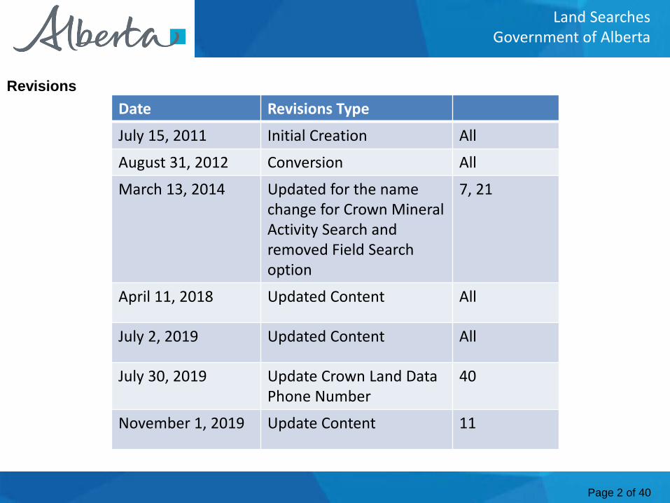
Date Revisions Type
July 15, 2011 Initial Creation All
August 31, 2012 Conversion All
March 13, 2014 Updated for the name change for Crown Mineral Activity Search and removed Field Search option
7, 21
April 11, 2018 Updated Content All
July 2, 2019 Updated Content All
July 30, 2019 Update Crown Land Data Phone Number
40
November 1, 2019 Update Content 11
Revisions
Page 3 of 40
Land SearchesGovernment of Alberta
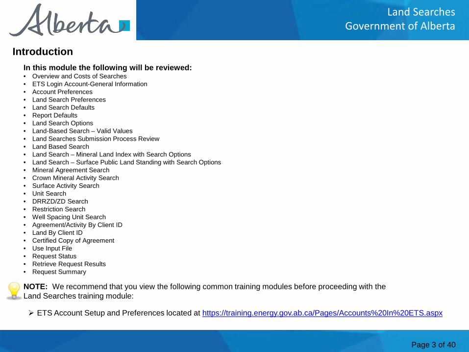
NOTE: We recommend that you view the following common training modules before proceeding with the Land Searches training module:
In this module the following will be reviewed:• Overview and Costs of Searches• ETS Login Account-General Information• Account Preferences• Land Search Preferences• Land Search Defaults• Report Defaults• Land Search Options• Land-Based Search – Valid Values• Land Searches Submission Process Review• Land Based Search• Land Search – Mineral Land Index with Search Options • Land Search – Surface Public Land Standing with Search Options• Mineral Agreement Search• Crown Mineral Activity Search• Surface Activity Search• Unit Search• DRRZD/ZD Search• Restriction Search• Well Spacing Unit Search• Agreement/Activity By Client ID• Land By Client ID• Certified Copy of Agreement• Use Input File• Request Status• Retrieve Request Results• Request Summary
Introduction
ETS Account Setup and Preferences located at https://training.energy.gov.ab.ca/Pages/Accounts%20In%20ETS.aspx
Page 4 of 40
Land SearchesGovernment of Alberta
Overview and Costs of SearchesMineral Land Index SearchTo search by a land description, this report will provide if selected; Agreements, Units, Wells, Restrictions, Crown Mineral Ownership, Fields, Projects, DRRZD/ZDs, Well Spacing and Units. The fee is $30.00 per request (Detail or Summary).Surface Public Land Standing SearchThis search returns information on any surface interest and/or activity in the specified parcel(s) of land that matches the search criteria entered. The report includes information on Land Status, Geo-Administrative Areas, Surface Activities, Titles, and client names/addresses. Fee $1 per land parcel* requested with a minimum fee of $5.00 to a maximum of $75.00.Surface Documentation Summary SearchThis report is a summary of the Surface Public Standing Search. Fee $1.00 per land parcel* requested with a minimum fee of $5.00 to a maximum of $75.00. *Land parcel means a quarter section, half section, section or consecutive sequence of sections up to and including one complete township.Mineral Land Index Search by Client IDThis search is by Land Description and Client ID, Specific Agreement Number(s) are not required. Report will provide if selected, Agreements, Units, Wells, Restrictions, Crown Mineral Ownership, Fields, Projects, DRRZD/ZDs, Well Spacing. & Units. Fee $30.00 per request (Detail or Summary). Maximum of 6 Client IDs per request.Surface Activity Detail SearchThis report provides surface activity information including; the Activity Type, Serial Number and Activity Type Decode, Status, Activity Area in Hectares and Acres, Client Name/Address, Ownership Flag, Service Address Flag, More Owners Flag, Key File ID, within 100 meters of a Waterbody Flag, Option to Purchase Flag, Application, Letter of Authority, Effective, Expiry, Cancellation, Reinstatement, Amendment, Renewal, Amended and LOA Dates. Fee: $6.00 for each Surface Activity Detail.Surface activity standing searchThis search returns information on any surface interest and/or activity that matches the search criteria entered, similar to the Surface Public Land Standing Search. This report utilizes the land keys of the requested surface activity to identify all other activities intersecting with it, the information is organized by quarter section. The report includes information on Land Status, Geo-Administrative Areas, Activities and Titles, and Client Name/Addresses. Fee $1 per land parcel* requested with a minimum fee of $5.00 with a maximum fee of $75.00 for each Surface Activity Standing Report.
* Land parcel means a quarter section, half section, section or consecutive sequence of sections up to and including one complete township.
Continued onto next page
Page 5 of 40
Land SearchesGovernment of Alberta
Overview and Costs of Searches - Continued
Mineral Agreement SearchThis report will provide agreement information which includes; the Agreement Status, Agreement Area, various dates, the Term of the Agreement, Term Adjustments, related Agreements, Service Address, Current Participants, Land/Zone Description, and Production Entity Activity. This report will be provided when Agreement Type(s) and Number(s) are supplied. Fee $6.00 per agreement.DRRZD/ZD SearchThis report will give detailed information about the requested DRRZD or ZD. A DRRZD/ZD is a unique ID number assigned by the Alberta Energy Regulator (AER). Fee $6.00 per DRRZD/ZD.Restriction SearchThis report will give detailed information about the requested restriction. Restrictions apply to areas in the province of Alberta that have surface access or geologic concerns in the development of mineral resources. Fee $6.00 per Restriction.Unit SearchThis report will give detailed information about the requested Unit. A Unit establishes a relationship between Lessees and Lessors to operate a group of leases for the recovery of Oil and Gas, as a single consolidated Unit without regard to separate ownerships. Fee $6.00 per Unit.Well Spacing Unit SearchWell Spacing Unit (SU order) is a specific area allocated by the AER for the purpose of drilling for and producing Oil or Gas. Which is not a standard Spacing Unit. The standard Spacing Units are one section for gas and a quarter-section for oil. Fee $6.00 per Well Spacing Unit.Mineral Agreement Search by Client IDThis report provides all Mineral Agreement Information for the requested Client ID(s). The report information is the same as the Mineral Agreement Search. Fee $30.00 per request, maximum of 6 Client ID(s) per requestUnit Search by Client IDThis report will provide all Unit Information for the requested Client ID(s). The report information is the same as the Unit Search.Fee $30.00 per request, maximum of 6 Client ID(s) per request.Surface Activity Search by Client IDThis report provides all Surface Activity Information for the requested Client ID(s). The report information is the same as the Surface Activity Detail Search. Fee $30.00 per request, maximum of 6 client ids per request.Certified Copy of AgreementA Certified Copy of an agreement can only be requested by the Designated Representative or a Lessee of the Agreement. The fee for a Certified Copy is $30.00 per document.
Page 6 of 40
Land SearchesGovernment of Alberta
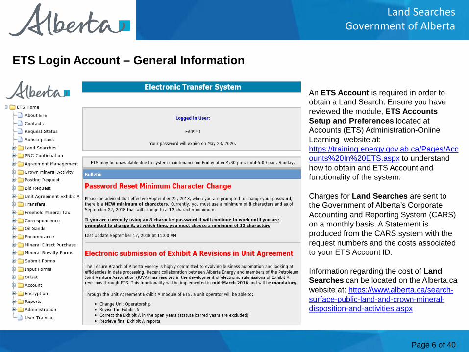
An ETS Account is required in order to obtain a Land Search. Ensure you have reviewed the module, ETS Accounts Setup and Preferences located at Accounts (ETS) Administration-Online Learning website at: https://training.energy.gov.ab.ca/Pages/Accounts%20In%20ETS.aspx to understand how to obtain and ETS Account and functionality of the system.
Charges for Land Searches are sent to the Government of Alberta’s Corporate Accounting and Reporting System (CARS) on a monthly basis. A Statement is produced from the CARS system with the request numbers and the costs associated to your ETS Account ID.
Information regarding the cost of Land Searches can be located on the Alberta.ca website at: https://www.alberta.ca/search-surface-public-land-and-crown-mineral-disposition-and-activities.aspx
ETS Login Account – General Information
Page 7 of 40
Land SearchesGovernment of Alberta
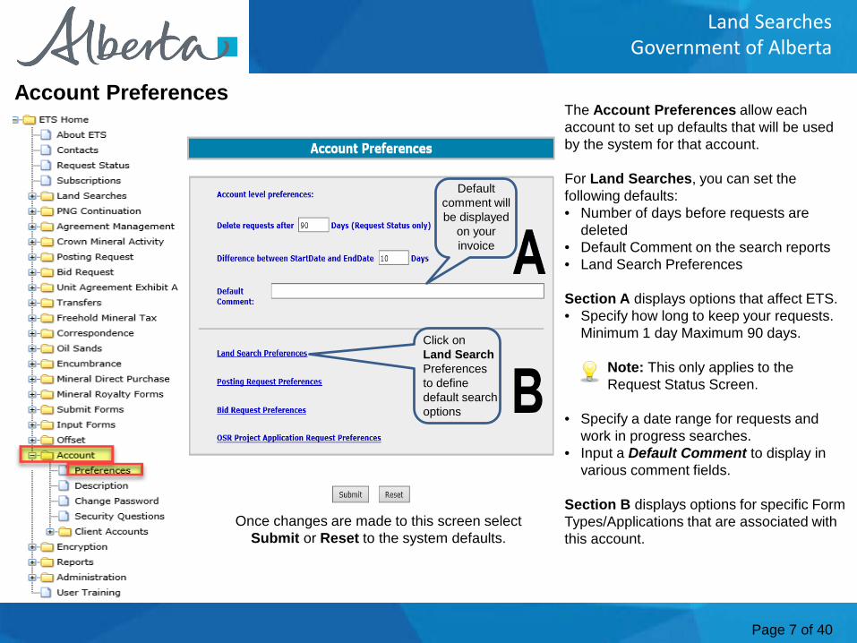
Account PreferencesThe Account Preferences allow each account to set up defaults that will be used by the system for that account.
For Land Searches, you can set the following defaults:• Number of days before requests are
deleted• Default Comment on the search reports• Land Search Preferences
Section A displays options that affect ETS.• Specify how long to keep your requests.
Minimum 1 day Maximum 90 days.
Note: This only applies to the Request Status Screen.
• Specify a date range for requests and work in progress searches.
• Input a Default Comment to display in various comment fields.
Section B displays options for specific Form Types/Applications that are associated with this account.
Once changes are made to this screen select Submit or Reset to the system defaults.
Default comment will be displayed
on your invoice
Click onLand Search Preferences to define default search options
Page 8 of 40
Land SearchesGovernment of Alberta
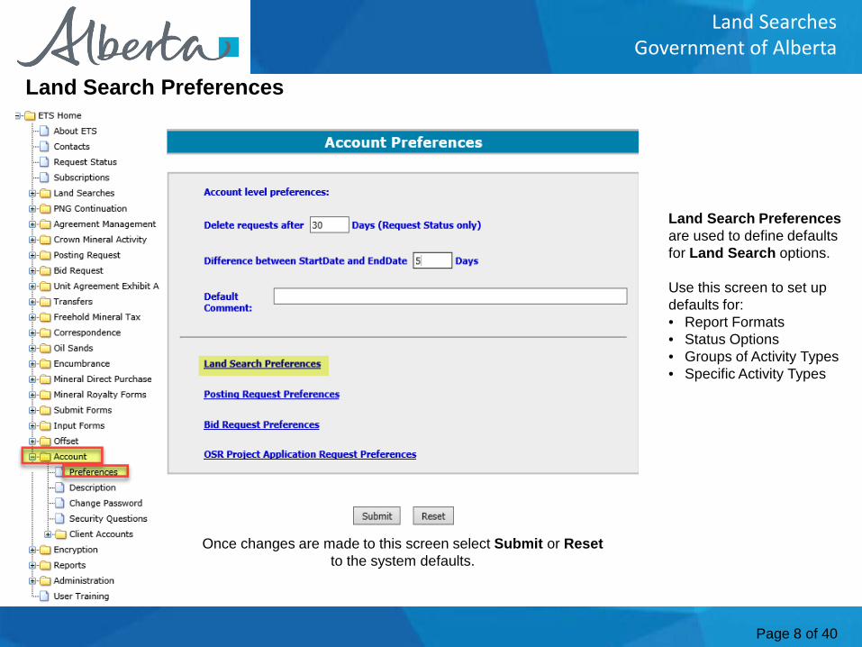
Land Search Preferencesare used to define defaults for Land Search options.
Use this screen to set up defaults for:• Report Formats• Status Options• Groups of Activity Types• Specific Activity Types
Land Search Preferences
Once changes are made to this screen select Submit or Resetto the system defaults.
Page 9 of 40
Land SearchesGovernment of Alberta
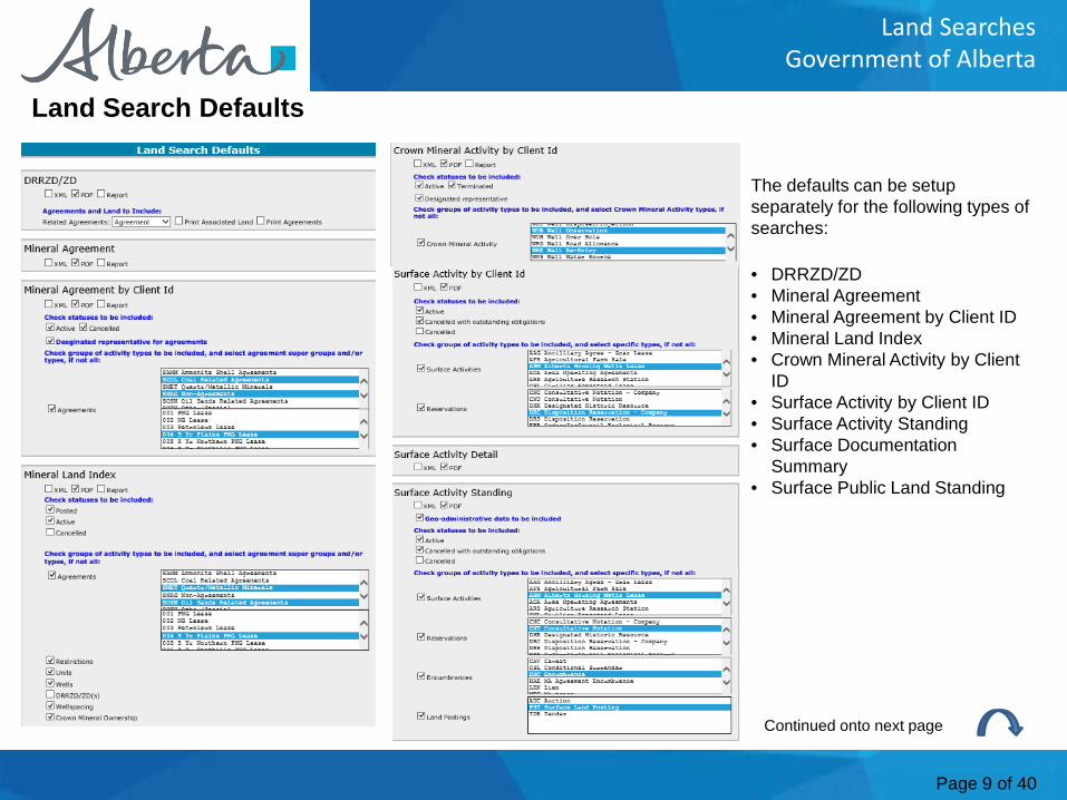
Land Search Defaults
The defaults can be setup separately for the following types of searches:
• DRRZD/ZD• Mineral Agreement• Mineral Agreement by Client ID• Mineral Land Index• Crown Mineral Activity by Client
ID• Surface Activity by Client ID• Surface Activity Standing• Surface Documentation
Summary• Surface Public Land Standing
Continued onto next page
Page 10 of 40
Land SearchesGovernment of Alberta
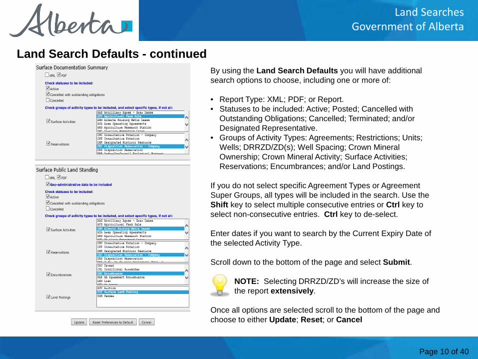
Land Search Defaults - continuedBy using the Land Search Defaults you will have additional search options to choose, including one or more of:
• Report Type: XML; PDF; or Report.• Statuses to be included: Active; Posted; Cancelled with
Outstanding Obligations; Cancelled; Terminated; and/or Designated Representative.
• Groups of Activity Types: Agreements; Restrictions; Units; Wells; DRRZD/ZD(s); Well Spacing; Crown Mineral Ownership; Crown Mineral Activity; Surface Activities; Reservations; Encumbrances; and/or Land Postings.
If you do not select specific Agreement Types or Agreement Super Groups, all types will be included in the search. Use the Shift key to select multiple consecutive entries or Ctrl key to select non-consecutive entries. Ctrl key to de-select.
Enter dates if you want to search by the Current Expiry Date of the selected Activity Type.
Scroll down to the bottom of the page and select Submit.
NOTE: Selecting DRRZD/ZD’s will increase the size of the report extensively.
Once all options are selected scroll to the bottom of the page and choose to either Update; Reset; or Cancel
Page 11 of 40
Land SearchesGovernment of Alberta
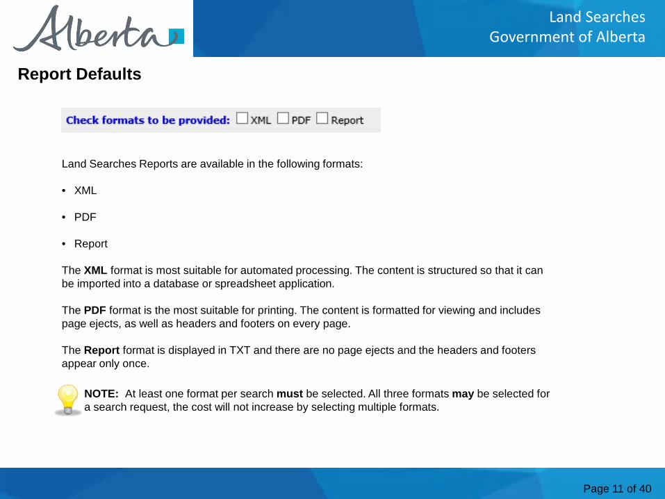
Land Searches Reports are available in the following formats:
• XML
• Report
The XML format is most suitable for automated processing. The content is structured so that it can be imported into a database or spreadsheet application.
The PDF format is the most suitable for printing. The content is formatted for viewing and includes page ejects, as well as headers and footers on every page.
The Report format is displayed in TXT and there are no page ejects and the headers and footers appear only once.
Report Defaults
NOTE: At least one format per search must be selected. All three formats may be selected for a search request, the cost will not increase by selecting multiple formats.
Page 12 of 40
Land SearchesGovernment of Alberta
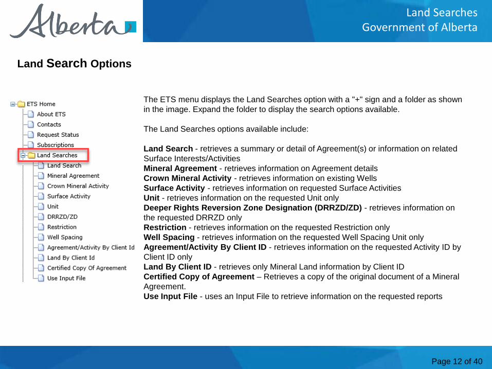
The ETS menu displays the Land Searches option with a "+" sign and a folder as shown in the image. Expand the folder to display the search options available.
The Land Searches options available include:
Land Search - retrieves a summary or detail of Agreement(s) or information on related Surface Interests/ActivitiesMineral Agreement - retrieves information on Agreement detailsCrown Mineral Activity - retrieves information on existing WellsSurface Activity - retrieves information on requested Surface ActivitiesUnit - retrieves information on the requested Unit onlyDeeper Rights Reversion Zone Designation (DRRZD/ZD) - retrieves information on the requested DRRZD onlyRestriction - retrieves information on the requested Restriction onlyWell Spacing - retrieves information on the requested Well Spacing Unit onlyAgreement/Activity By Client ID - retrieves information on the requested Activity ID by Client ID onlyLand By Client ID - retrieves only Mineral Land information by Client ID Certified Copy of Agreement – Retrieves a copy of the original document of a Mineral Agreement.Use Input File - uses an Input File to retrieve information on the requested reports
Land Search Options
Page 13 of 40
Land SearchesGovernment of Alberta
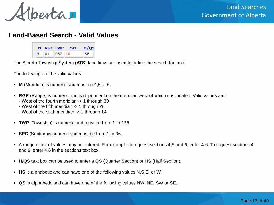
The Alberta Township System (ATS) land keys are used to define the search for land.
The following are the valid values:
• M (Meridian) is numeric and must be 4,5 or 6.
• RGE (Range) is numeric and is dependent on the meridian west of which it is located. Valid values are: - West of the fourth meridian -> 1 through 30- West of the fifth meridian -> 1 through 28- West of the sixth meridian -> 1 through 14
• TWP (Township) is numeric and must be from 1 to 126.
• SEC (Section)is numeric and must be from 1 to 36.
• A range or list of values may be entered. For example to request sections 4,5 and 6, enter 4-6. To request sections 4 and 6, enter 4,6 in the sections text box.
• H/QS text box can be used to enter a QS (Quarter Section) or HS (Half Section).
• HS is alphabetic and can have one of the following values N,S,E, or W.
• QS is alphabetic and can have one of the following values NW, NE, SW or SE.
Land-Based Search - Valid Values
Page 14 of 40
Land SearchesGovernment of Alberta
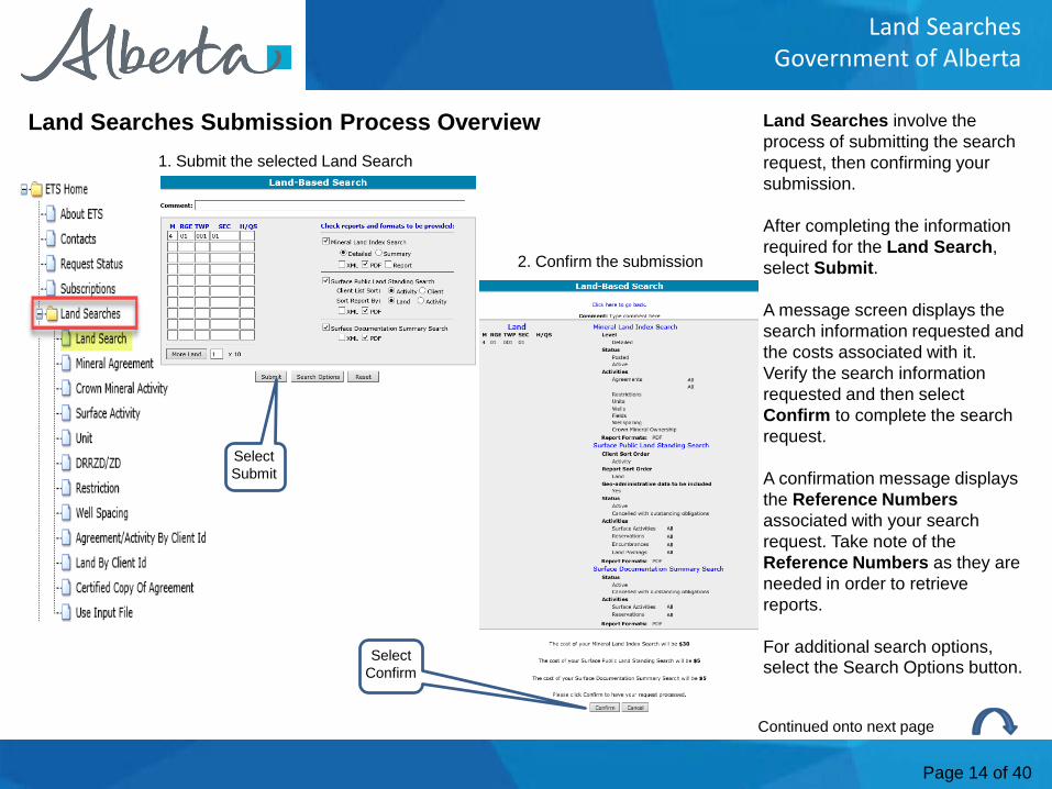
Land Searches involve the process of submitting the search request, then confirming your submission.
After completing the information required for the Land Search, select Submit.
A message screen displays the search information requested and the costs associated with it. Verify the search information requested and then select Confirm to complete the search request.
A confirmation message displays the Reference Numbers associated with your search request. Take note of the Reference Numbers as they are needed in order to retrieve reports.
For additional search options, select the Search Options button.
Land Searches Submission Process Overview1. Submit the selected Land Search
2. Confirm the submission
Continued onto next page
Select Submit
Select Confirm
Page 15 of 40
Land SearchesGovernment of Alberta
Land Searches Submission Process Overview - Continued
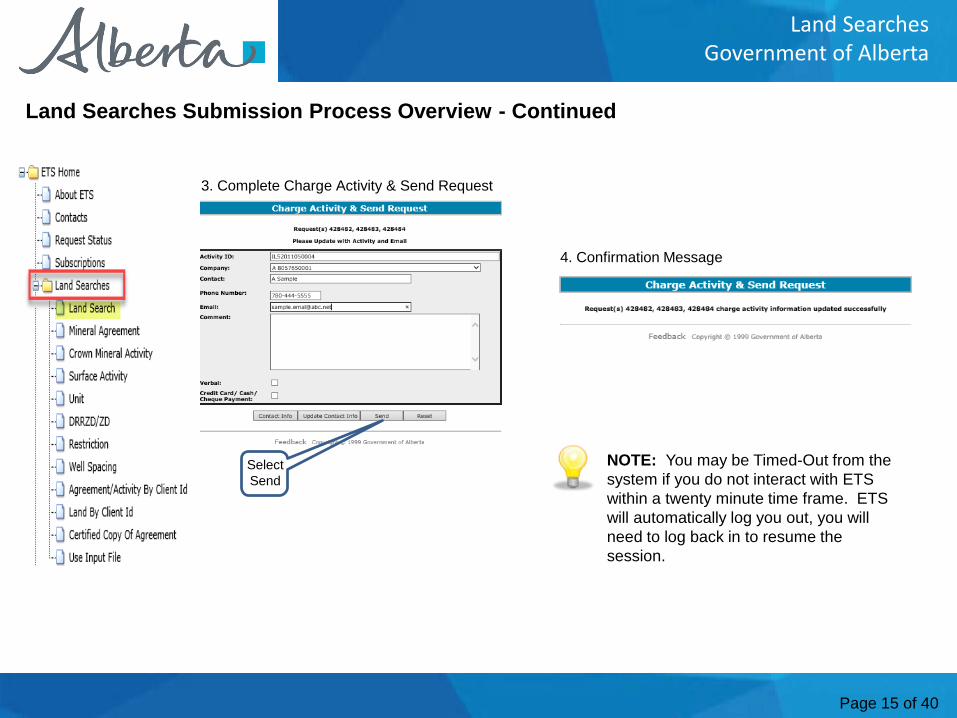
3. Complete Charge Activity & Send Request
Select Send
4. Confirmation Message
NOTE: You may be Timed-Out from the system if you do not interact with ETS within a twenty minute time frame. ETS will automatically log you out, you will need to log back in to resume the session.
Page 16 of 40
Land SearchesGovernment of Alberta
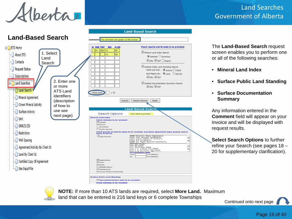
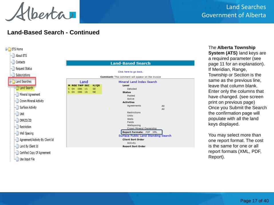
The Land-Based Search request screen enables you to perform one or all of the following searches:
• Mineral Land Index
• Surface Public Land Standing
• Surface Documentation Summary
Any information entered in the Comment field will appear on your invoice and will be displayed with request results.
Select Search Options to further refine your Search (see pages 18 –20 for supplementary clarification).
Land-Based Search
1. Select Land Search
NOTE: If more than 10 ATS lands are required, select More Land. Maximum land that can be entered is 216 land keys or 6 complete Townships
2. Enter one or more ATS Land identifiers (description of how to use see next page)
Continued onto next page
Page 17 of 40
Land SearchesGovernment of Alberta
The Alberta Township System (ATS) land keys are a required parameter (see page 11 for an explanation). If Meridian, Range, Township or Section is the same as the previous line, leave that column blank. Enter only the columns that have changed. (see screen print on previous page) Once you Submit the Search the confirmation page will populate with all the land keys displayed.
You may select more than one report format. The cost is the same for one or all report formats (XML, PDF, Report).
Land-Based Search - Continued
Page 18 of 40
Land SearchesGovernment of Alberta
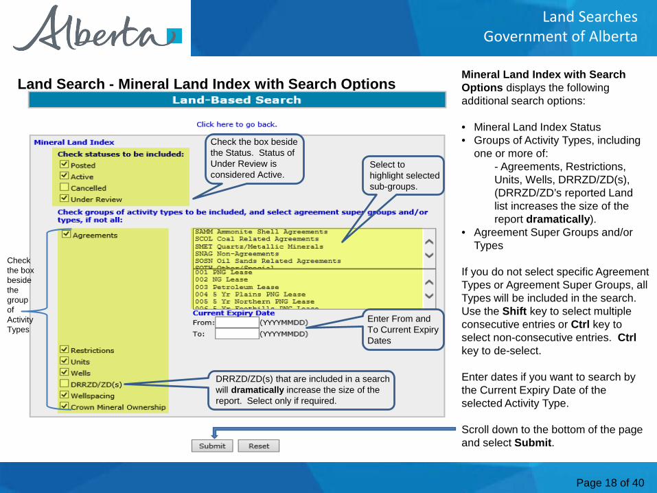
Mineral Land Index with Search Options displays the following additional search options:
• Mineral Land Index Status• Groups of Activity Types, including
one or more of:- Agreements, Restrictions, Units, Wells, DRRZD/ZD(s), (DRRZD/ZD’s reported Land list increases the size of the report dramatically).
• Agreement Super Groups and/or Types
If you do not select specific Agreement Types or Agreement Super Groups, all Types will be included in the search. Use the Shift key to select multiple consecutive entries or Ctrl key to select non-consecutive entries. Ctrlkey to de-select.
Enter dates if you want to search by the Current Expiry Date of the selected Activity Type.
Scroll down to the bottom of the page and select Submit.
Land Search - Mineral Land Index with Search Options
Check the box beside the Status. Status of Under Review is considered Active.
Select to highlight selected sub-groups.
Enter From and To Current Expiry Dates
DRRZD/ZD(s) that are included in a search will dramatically increase the size of the report. Select only if required.
Check the box beside the group of Activity Types
Page 19 of 40
Land SearchesGovernment of Alberta
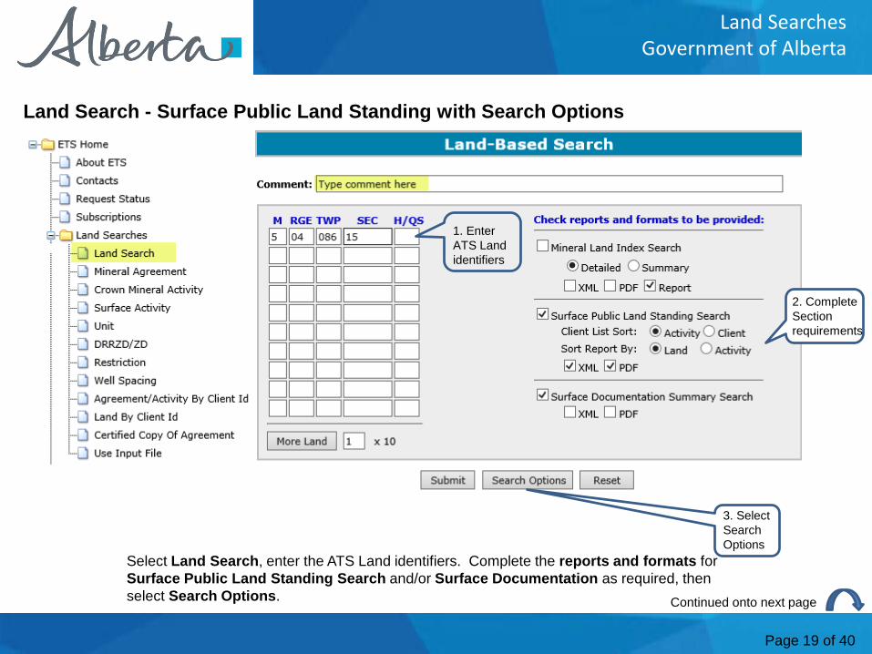
Land Search - Surface Public Land Standing with Search Options
Continued onto next page
Select Land Search, enter the ATS Land identifiers. Complete the reports and formats for Surface Public Land Standing Search and/or Surface Documentation as required, then select Search Options.
2. Complete Section requirements
3. Select Search Options
1. Enter ATS Land identifiers
Page 20 of 40
Land SearchesGovernment of Alberta
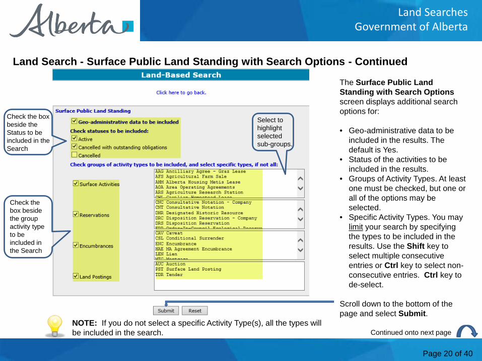
The Surface Public Land Standing with Search Optionsscreen displays additional search options for:
• Geo-administrative data to be included in the results. The default is Yes.
• Status of the activities to be included in the results.
• Groups of Activity Types. At least one must be checked, but one or all of the options may be selected.
• Specific Activity Types. You may limit your search by specifying the types to be included in the results. Use the Shift key to select multiple consecutive entries or Ctrl key to select non-consecutive entries. Ctrl key to de-select.
Scroll down to the bottom of the page and select Submit.
Land Search - Surface Public Land Standing with Search Options - Continued
Check the box beside the Status to be included in the Search
Check the box beside the group activity type to be included in the Search
NOTE: If you do not select a specific Activity Type(s), all the types will be included in the search. Continued onto next page
Select to highlight selected sub-groups.
Page 21 of 40
Land SearchesGovernment of Alberta
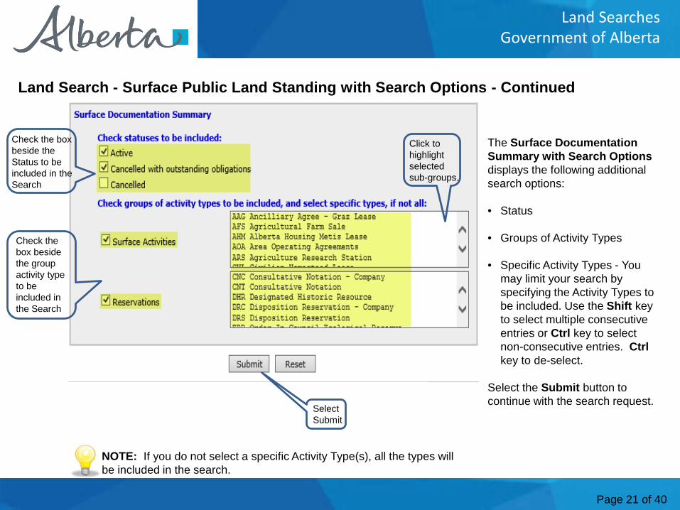
The Surface Documentation Summary with Search Optionsdisplays the following additional search options:
• Status
• Groups of Activity Types
• Specific Activity Types - You may limit your search by specifying the Activity Types to be included. Use the Shift key to select multiple consecutive entries or Ctrl key to select non-consecutive entries. Ctrlkey to de-select.
Select the Submit button to continue with the search request.
Land Search - Surface Public Land Standing with Search Options - Continued
Check the box beside the Status to be included in the Search
Check the box beside the group activity type to be included in the Search
Click to highlight selected sub-groups.
Select Submit
NOTE: If you do not select a specific Activity Type(s), all the types will be included in the search.
Page 22 of 40
Land SearchesGovernment of Alberta
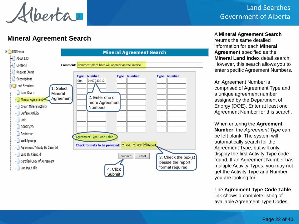
A Mineral Agreement Searchreturns the same detailed information for each MineralAgreement specified as the Mineral Land Index detail search. However, this search allows you to enter specific Agreement Numbers.
An Agreement Number is comprised of Agreement Type and a unique agreement number assigned by the Department of Energy (DOE). Enter at least one Agreement Number for this search.
When entering the Agreement Number, the Agreement Type can be left blank. The system will automatically search for the Agreement Type, but will only display the first Activity Type code found. If an Agreement Number has multiple Activity Types, you may not get the Activity Type and Number you are looking for.
The Agreement Type Code Tablelink shows a complete listing of available Agreement Type Codes.
Mineral Agreement Search
1. Select Mineral Agreement 2. Enter one or
more Agreement Numbers
3. Check the box(s) beside the report format required.4. Click
Submit
Page 23 of 40
Land SearchesGovernment of Alberta
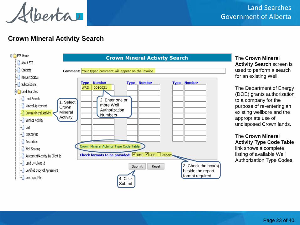
The Crown Mineral Activity Search screen is used to perform a search for an existing Well.
The Department of Energy (DOE) grants authorization to a company for the purpose of re-entering an existing wellbore and the appropriate use of undisposed Crown lands.
The Crown Mineral Activity Type Code Tablelink shows a complete listing of available Well Authorization Type Codes.
Crown Mineral Activity Search
1. Select Crown Mineral Activity
2. Enter one or more Well Authorization Numbers
3. Check the box(s) beside the report format required.4. Click
Submit
Page 24 of 40
Land SearchesGovernment of Alberta
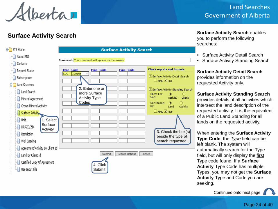
Surface Activity Search enables you to perform the following searches:
• Surface Activity Detail Search• Surface Activity Standing Search
Surface Activity Detail Searchprovides information on the requested Activity only.
Surface Activity Standing Searchprovides details of all activities which intersect the land description of the requested activity. It is the equivalent of a Public Land Standing for all lands on the requested activity.
When entering the Surface Activity Type Code, the Type field can be left blank. The system will automatically search for the Type field, but will only display the firstType code found. If a Surface Activity Type Code has multiple Types, you may not get the Surface Activity Type and Code you are seeking.
Surface Activity Search
Continued onto next page
1. Select Surface Activity
2. Enter one or more Surface Activity Type Codes
3. Check the box(s) beside the type of search requested
4. Click Submit
Page 25 of 40
Land SearchesGovernment of Alberta
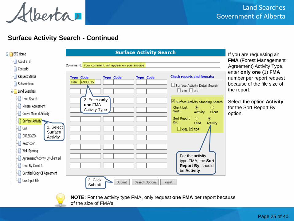
If you are requesting an FMA (Forest Management Agreement) Activity Type, enter only one (1) FMAnumber per report request because of the file size of the report.
Select the option Activityfor the Sort Report By option.
Surface Activity Search - Continued
1. Select Surface Activity
NOTE: For the activity type FMA, only request one FMA per report because of the size of FMA’s.
3. Click Submit
2. Enter onlyone FMA Activity Type
For the activity type FMA, the Sort Report By, should be Activity
Page 26 of 40
Land SearchesGovernment of Alberta
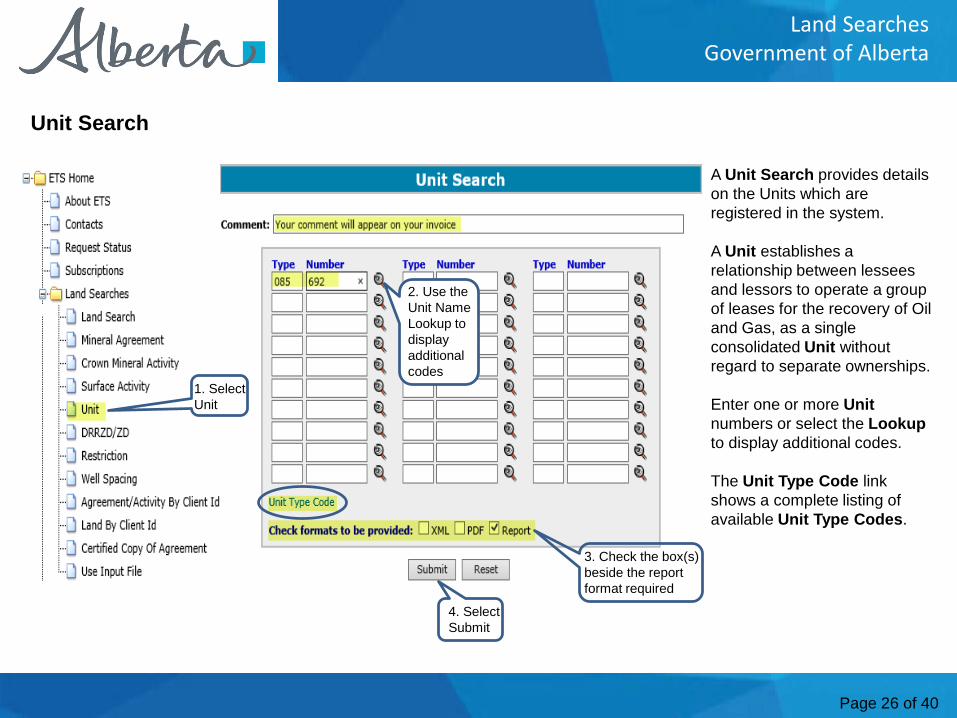
A Unit Search provides details on the Units which are registered in the system.
A Unit establishes a relationship between lessees and lessors to operate a group of leases for the recovery of Oil and Gas, as a single consolidated Unit without regard to separate ownerships.
Enter one or more Unitnumbers or select the Lookupto display additional codes.
The Unit Type Code link shows a complete listing of available Unit Type Codes.
Unit Search
1. Select Unit
2. Use the Unit Name Lookup to display additional codes
4. Select Submit
3. Check the box(s) beside the report format required
Page 27 of 40
Land SearchesGovernment of Alberta
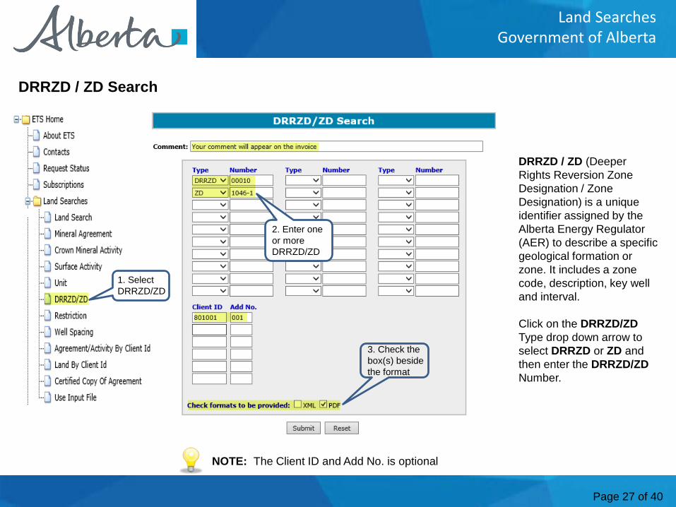
DRRZD / ZD (Deeper Rights Reversion Zone Designation / Zone Designation) is a unique identifier assigned by the Alberta Energy Regulator (AER) to describe a specific geological formation or zone. It includes a zone code, description, key well and interval.
Click on the DRRZD/ZDType drop down arrow to select DRRZD or ZD and then enter the DRRZD/ZDNumber.
DRRZD / ZD Search
NOTE: The Client ID and Add No. is optional
1. Select DRRZD/ZD
2. Enter one or more DRRZD/ZD
3. Check the box(s) beside the format
Page 28 of 40
Land SearchesGovernment of Alberta
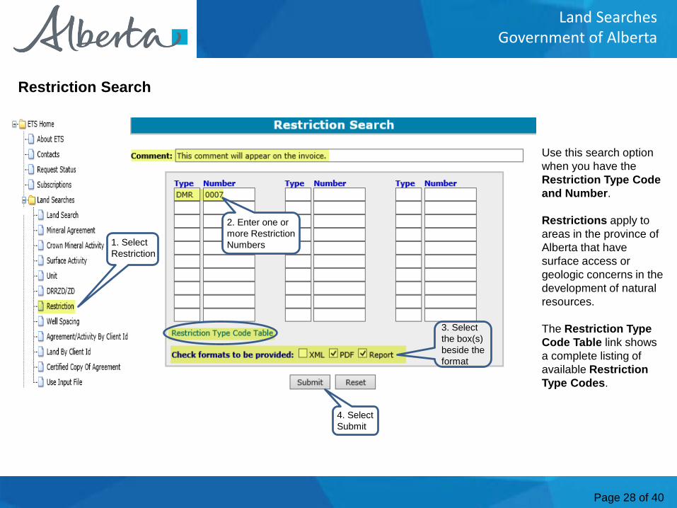
Use this search option when you have the Restriction Type Code and Number.
Restrictions apply to areas in the province of Alberta that have surface access or geologic concerns in the development of natural resources.
The Restriction Type Code Table link shows a complete listing of available Restriction Type Codes.
Restriction Search
1. Select Restriction
2. Enter one or more Restriction Numbers
3. Select the box(s) beside the format
4. Select Submit
Page 29 of 40
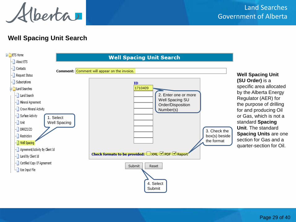
Land SearchesGovernment of Alberta
Well Spacing Unit (SU Order) is a specific area allocated by the Alberta Energy Regulator (AER) for the purpose of drilling for and producing Oil or Gas, which is not a standard Spacing Unit. The standard Spacing Units are one section for Gas and a quarter-section for Oil.
Well Spacing Unit Search
1. Select Well Spacing
2. Enter one or more Well Spacing SU Order/Disposition Number(s)
3. Check the box(s) beside the format
4. Select Submit
Page 30 of 40
Land SearchesGovernment of Alberta
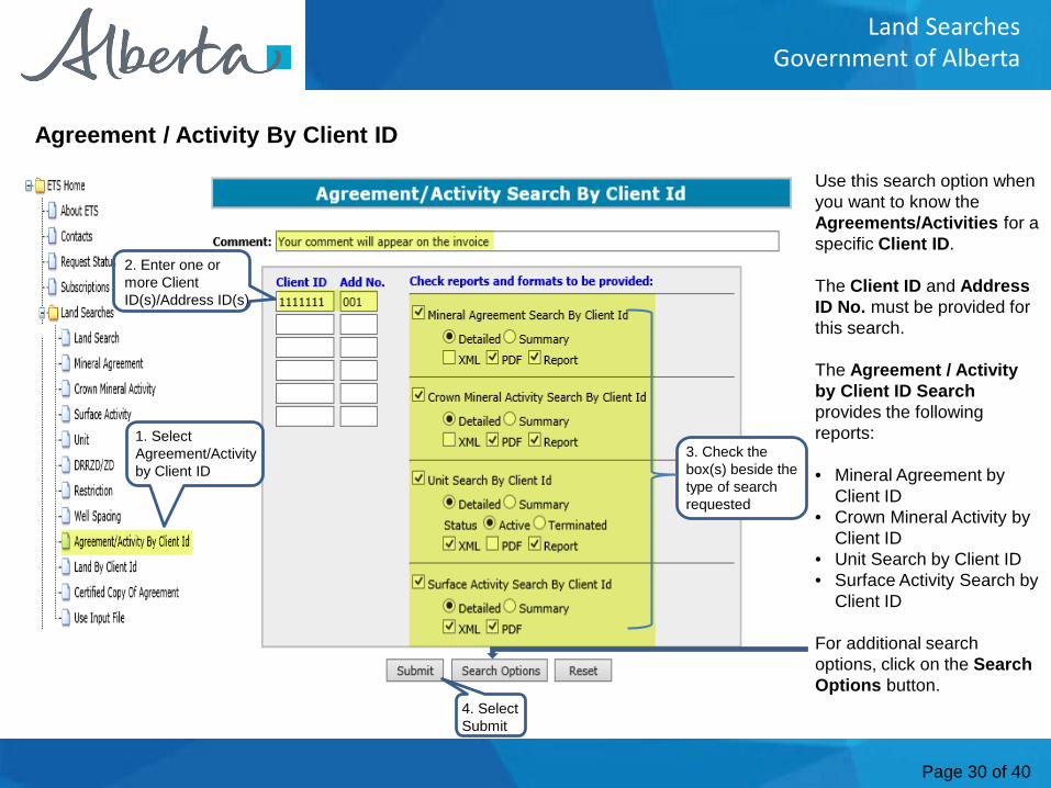
Use this search option when you want to know the Agreements/Activities for a specific Client ID.
The Client ID and Address ID No. must be provided for this search.
The Agreement / Activity by Client ID Searchprovides the following reports:
• Mineral Agreement by Client ID
• Crown Mineral Activity by Client ID
• Unit Search by Client ID• Surface Activity Search by
Client ID
For additional search options, click on the Search Options button.
Agreement / Activity By Client ID
1. Select Agreement/Activity by Client ID
4. Select Submit
2. Enter one or more Client ID(s)/Address ID(s)
3. Check the box(s) beside the type of search requested
Page 31 of 40
Land SearchesGovernment of Alberta
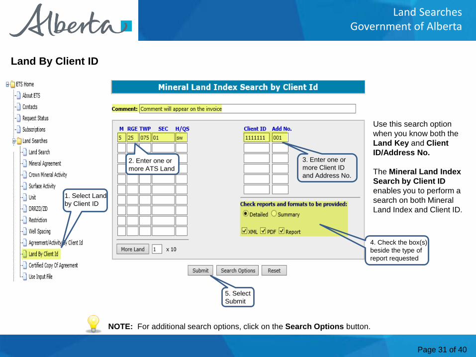
Use this search option when you know both the Land Key and ClientID/Address No.
The Mineral Land Index Search by Client IDenables you to perform a search on both Mineral Land Index and Client ID.
Land By Client ID
NOTE: For additional search options, click on the Search Options button.
1. Select Land by Client ID
5. Select Submit
2. Enter one or more ATS Land
3. Enter one or more Client ID and Address No.
4. Check the box(s) beside the type of report requested
Page 32 of 40
Land SearchesGovernment of Alberta
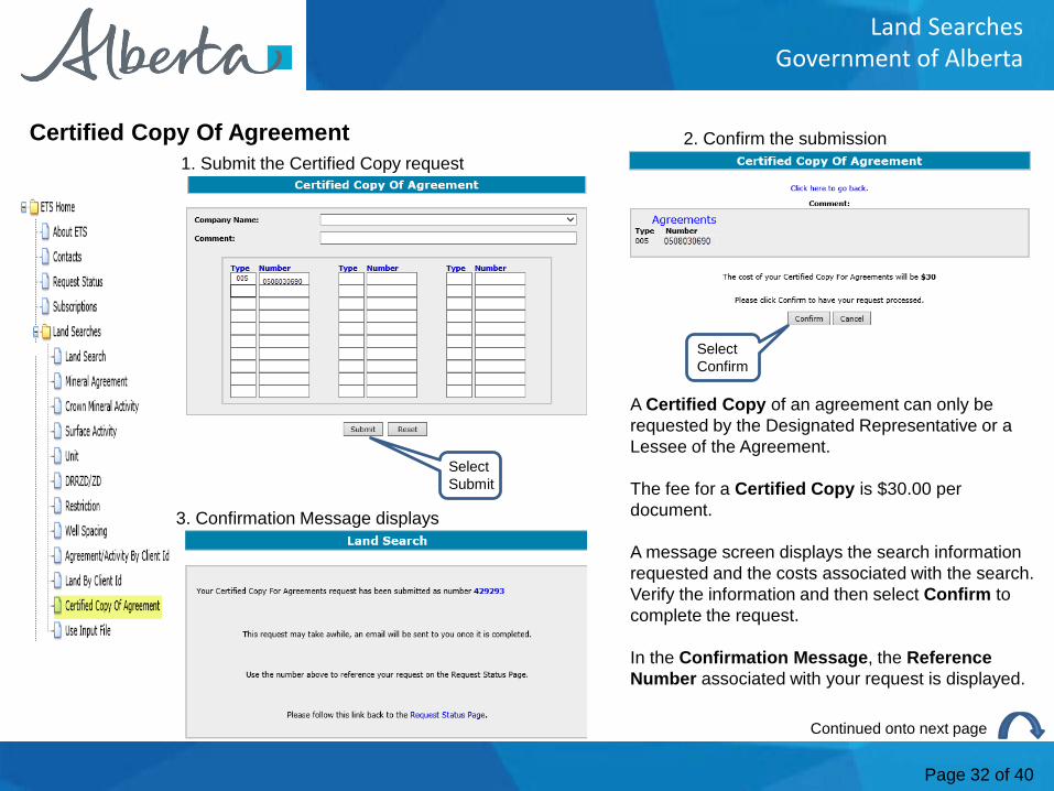
Certified Copy Of Agreement
A Certified Copy of an agreement can only be requested by the Designated Representative or a Lessee of the Agreement.
The fee for a Certified Copy is $30.00 per document.
A message screen displays the search information requested and the costs associated with the search. Verify the information and then select Confirm to complete the request.
In the Confirmation Message, the ReferenceNumber associated with your request is displayed.
2. Confirm the submission1. Submit the Certified Copy request
3. Confirmation Message displays
Select Submit
Select Confirm
Continued onto next page
Page 33 of 40
Land SearchesGovernment of Alberta
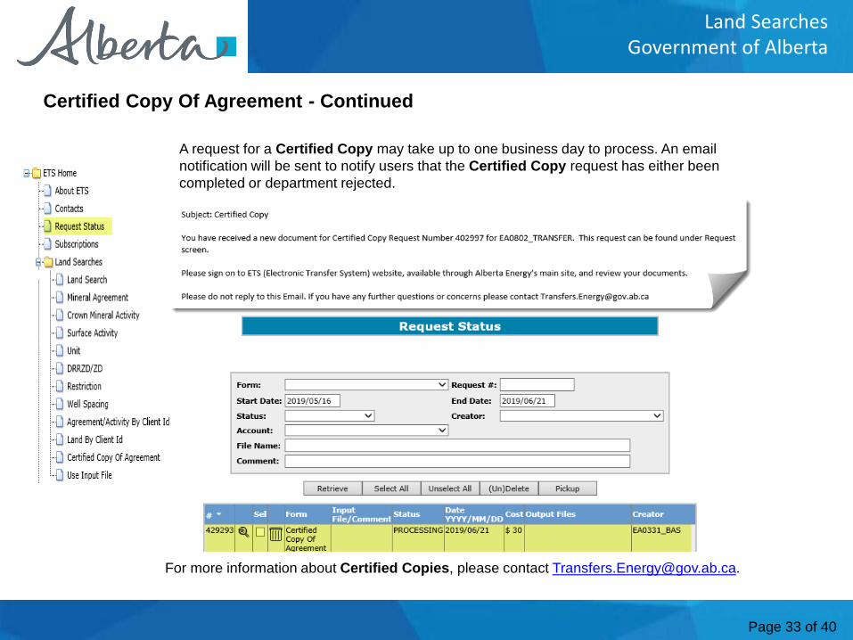
Certified Copy Of Agreement - Continued
A request for a Certified Copy may take up to one business day to process. An email notification will be sent to notify users that the Certified Copy request has either been completed or department rejected.
For more information about Certified Copies, please contact [email protected].
Page 34 of 40
Land SearchesGovernment of Alberta
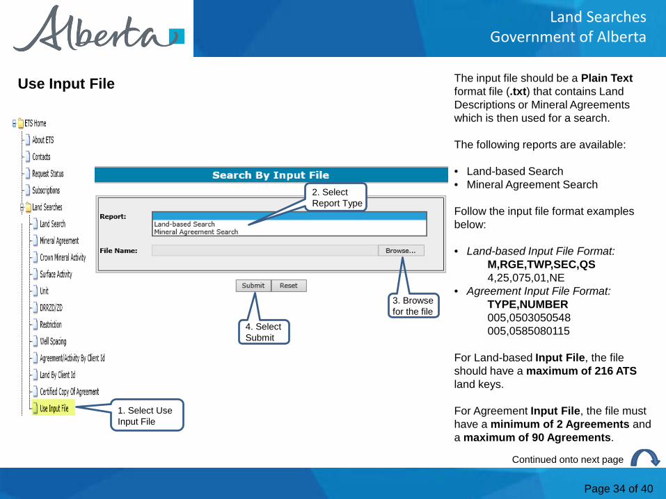
The input file should be a Plain Text format file (.txt) that contains Land Descriptions or Mineral Agreements which is then used for a search.
The following reports are available:
• Land-based Search• Mineral Agreement Search
Follow the input file format examples below:
• Land-based Input File Format:M,RGE,TWP,SEC,QS4,25,075,01,NE
• Agreement Input File Format:TYPE,NUMBER005,0503050548005,0585080115
For Land-based Input File, the file should have a maximum of 216 ATS land keys.
For Agreement Input File, the file must have a minimum of 2 Agreements and a maximum of 90 Agreements.
Use Input File
1. Select Use Input File
2. Select Report Type
3. Browse for the file
4. Select Submit
Continued onto next page
Page 35 of 40
Land SearchesGovernment of Alberta
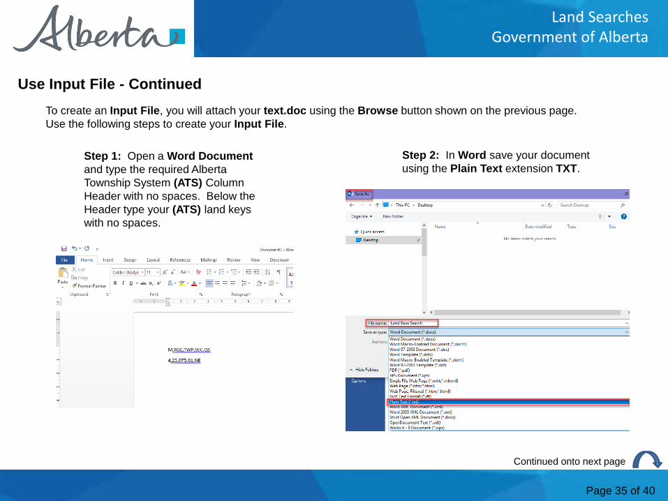
Use Input File - ContinuedTo create an Input File, you will attach your text.doc using the Browse button shown on the previous page. Use the following steps to create your Input File.
Step 1: Open a Word Documentand type the required Alberta Township System (ATS) Column Header with no spaces. Below the Header type your (ATS) land keys with no spaces.
Step 2: In Word save your document using the Plain Text extension TXT.
Continued onto next page
Page 36 of 40
Land SearchesGovernment of Alberta
Use Input File - Continued
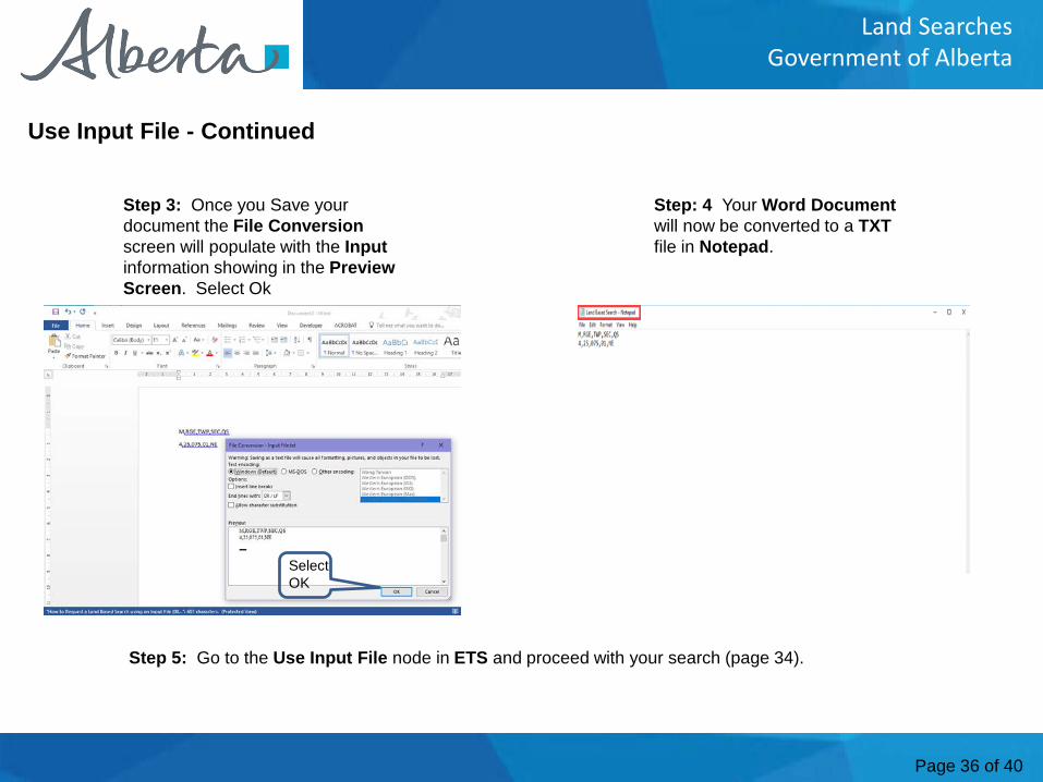
Step 3: Once you Save your document the File Conversion screen will populate with the Inputinformation showing in the PreviewScreen. Select Ok
Select OK
Step: 4 Your Word Document will now be converted to a TXTfile in Notepad.
Step 5: Go to the Use Input File node in ETS and proceed with your search (page 34).
Page 37 of 40
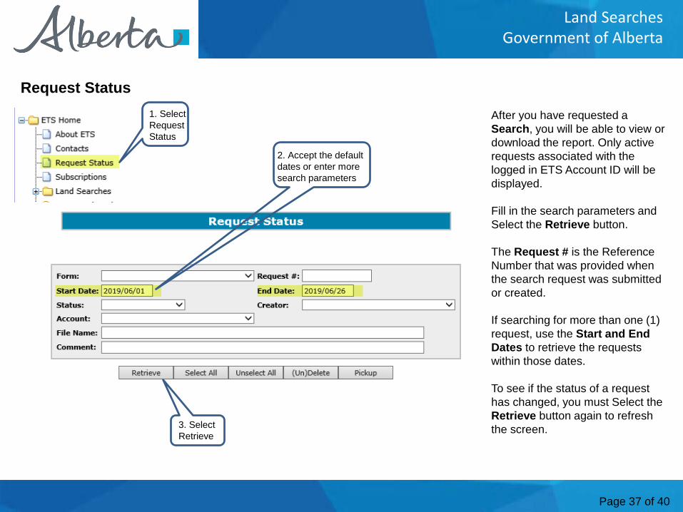
Land SearchesGovernment of Alberta
After you have requested a Search, you will be able to view or download the report. Only active requests associated with the logged in ETS Account ID will be displayed.
Fill in the search parameters and Select the Retrieve button.
The Request # is the Reference Number that was provided when the search request was submitted or created.
If searching for more than one (1) request, use the Start and End Dates to retrieve the requests within those dates.
To see if the status of a request has changed, you must Select the Retrieve button again to refresh the screen.
Request Status1. Select Request Status
2. Accept the default dates or enter more search parameters
3. Select Retrieve
Page 38 of 40
Land SearchesGovernment of Alberta
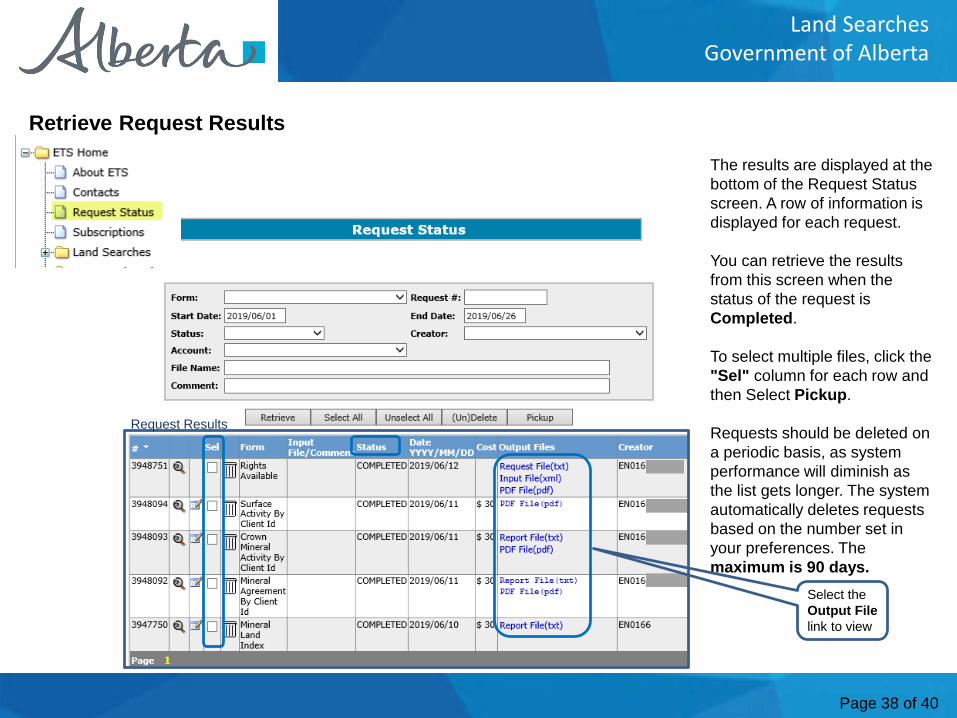
The results are displayed at the bottom of the Request Status screen. A row of information is displayed for each request.
You can retrieve the results from this screen when the status of the request is Completed.
To select multiple files, click the "Sel" column for each row and then Select Pickup.
Requests should be deleted on a periodic basis, as system performance will diminish as the list gets longer. The system automatically deletes requests based on the number set in your preferences. The maximum is 90 days.
Retrieve Request Results
Request Results
Select the Output File link to view
Page 39 of 40
Land SearchesGovernment of Alberta
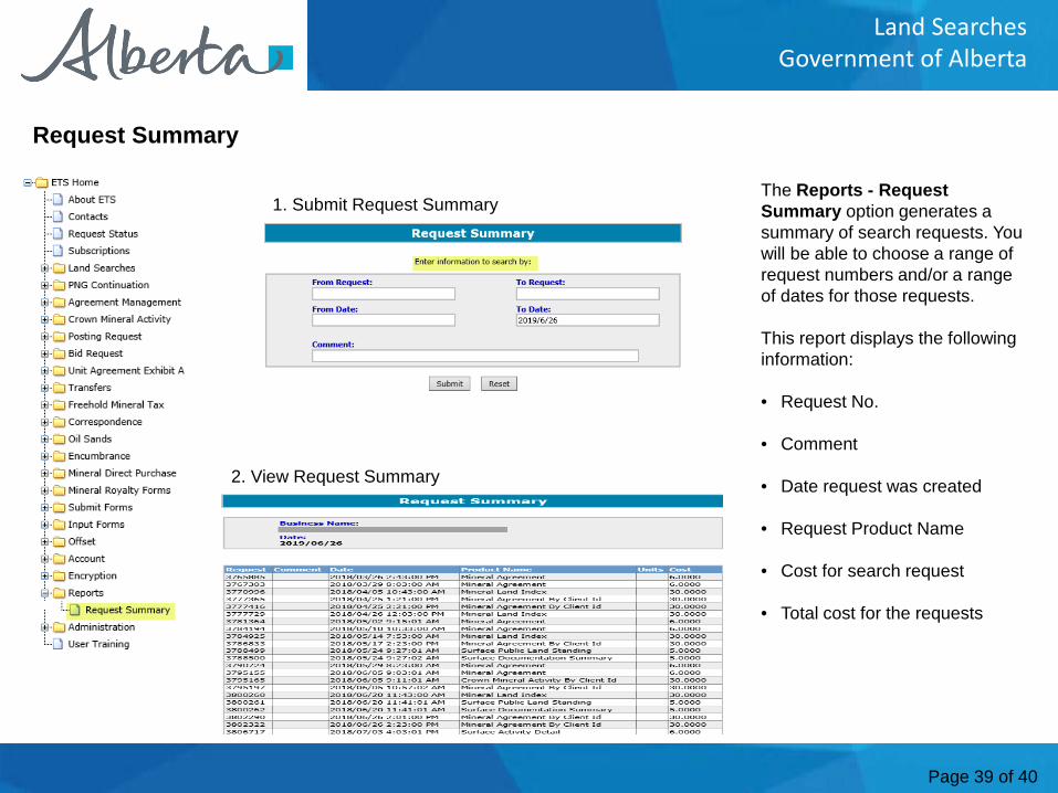
The Reports - Request Summary option generates a summary of search requests. You will be able to choose a range of request numbers and/or a range of dates for those requests.
This report displays the following information:
• Request No.
• Comment
• Date request was created
• Request Product Name
• Cost for search request
• Total cost for the requests
Request Summary
1. Submit Request Summary
2. View Request Summary
Page 40 of 40
Land SearchesGovernment of Alberta
Congratulations!You have completed the ETS – Land Searches
Online Training Course
Conclusion
To access Courses, Guides, Forms for all of your ETS Businessplease see ETS Support & Alberta Online Learning at: https://training.energy.gov.ab.ca/Pages/Accounts%20In%20ETS.aspx
For information on your ETS account, please contact:
Alberta Energy Crown Land DataPhone: (780) 644-2300 E-mail inquiries: [email protected]