Embed Size (px)
Citation preview
Environmental Assessment Tree Removal to Improve FAA Radar Coverage Youngstown Air Reserve Station Youngstown – Warren Regional Airport Vienna, Ohio 44473 Submitted to:
Youngstown Air Reserve Station 910TH Airlift Wing 910 MSG/CEV Contract No. FA6656-09-F-053 Prepared by:
Weston Solutions, Inc. 711 E. Monument Avenue Dayton, OH 45402 December 2009

Report Documentation Page Form ApprovedOMB No. 0704-0188
Public reporting burden for the collection of information is estimated to average 1 hour per response, including the time for reviewing instructions, searching existing data sources, gathering andmaintaining the data needed, and completing and reviewing the collection of information. Send comments regarding this burden estimate or any other aspect of this collection of information,including suggestions for reducing this burden, to Washington Headquarters Services, Directorate for Information Operations and Reports, 1215 Jefferson Davis Highway, Suite 1204, ArlingtonVA 22202-4302. Respondents should be aware that notwithstanding any other provision of law, no person shall be subject to a penalty for failing to comply with a collection of information if itdoes not display a currently valid OMB control number.
1. REPORT DATE DEC 2009 2. REPORT TYPE
3. DATES COVERED 00-00-2009 to 00-00-2009
4. TITLE AND SUBTITLE Environmental Assessment: Tree Removal to Improve FAA RadarCoverage Youngstown Air Reserve Station
5a. CONTRACT NUMBER
5b. GRANT NUMBER
5c. PROGRAM ELEMENT NUMBER
6. AUTHOR(S) 5d. PROJECT NUMBER
5e. TASK NUMBER
5f. WORK UNIT NUMBER
7. PERFORMING ORGANIZATION NAME(S) AND ADDRESS(ES) Weston Solutions Inc,711 E. Monument Avenue,Dayton,OH,45402
8. PERFORMING ORGANIZATIONREPORT NUMBER
9. SPONSORING/MONITORING AGENCY NAME(S) AND ADDRESS(ES) 10. SPONSOR/MONITOR’S ACRONYM(S)
11. SPONSOR/MONITOR’S REPORT NUMBER(S)
12. DISTRIBUTION/AVAILABILITY STATEMENT Approved for public release; distribution unlimited
13. SUPPLEMENTARY NOTES
14. ABSTRACT
15. SUBJECT TERMS
16. SECURITY CLASSIFICATION OF: 17. LIMITATION OF ABSTRACT Same as
Report (SAR)
18. NUMBEROF PAGES
73
19a. NAME OFRESPONSIBLE PERSON
a. REPORT unclassified
b. ABSTRACT unclassified
c. THIS PAGE unclassified
Standard Form 298 (Rev. 8-98) Prescribed by ANSI Std Z39-18

Introduction
FINDING OF NO SIGNIFICANT IMPACT
Environmental Assessment
Tree Removal to Improve FAA Radar Coverage Youngstown Air Reserve Station
An environmental assessment (EA) was prepared to evaluate the environmental consequences of a request for assistance from the Federal Aviation Administration (FAA) to improve low altitude radar coverage for the Youngstown-Warren Regional Airport (YNG). The trees have been shown to interfere with radar signals from the Youngstown-Warren Regional Airport (YNG) Airport Surveillance Radar tower, thereby impacting the Air Traffic Control Tower's (ATCT) ability to provide complete coverage for all civilian and military low altitude flights emanating from the northeast.
The purpose of the proposed action is to protect human health and safety by removing the trees interfering with radar coverage to the extent necessary within an approximately 20 acre wedge of the woodlot in the northeast section of YARS. This woodlot, including the proposed action wedge, also contains jurisdictional wetlands. Approximately 6.5 acres of jurisdictional wetlands are within the 20 acre proposed action site. An EA has been prepared to evaluate the environmental consequences of a request for assistance from the Federal Aviation Administration (FAA) in determining the most viable approach with the least impact to address the radar coverage issue while ensuring that the US Air Force fulfills its legal obligations as stewards of the Federal land, including protection of the wetlands.
Proposed Action and Alternatives
A number of potential approaches or alternatives addressing the issue of the trees interfering with radar coverage were evaluated and eliminated from further study due to potential impact and/or lack of feasibility. These included tree clearing by bulldozing and similar methods as well as topping of the tree canopies at heights above 35 feet.
In addition to the Proposed Action, Selective Tree Removal, a No Action alternative and a Clear Cutting Alternative were evaluated. Under the No Action Alternative, no tree cutting or removal would occur. The current radar coverage problem would continue and current flight safety issues would persist.
Under the Clear Cutting Alternative. all of the trees within the approximately 20 acre wedge would be cut/removed by commercial logging methods. All trees of sufficient size would be cleared to stump level and the trees would be removed from the woodlot and YARS. Logging debris would also be removed and properly disposed of off base. None of the wood is considered mercantile. The impact evaluation analysis identified

specific impact avoidance and mitigation measures that were incorporated into this and the Proposed Action alternatives.
Proposed Action: Selective Tree Removal
The Proposed Action is also recommended as the Preferred Alternative. The Proposed Action calls for development of a plan that will include selective removal of one-half to two-thirds of the trees located in the woodlot wedge that are over 35 feet high, which includes nearly all of the trees in the woodlot. The proposed plan is flexible as to the actual approach used to remove the trees within the woodlot, ranging from the selective cutting of individual larger and taller trees, to clear cutting plots or corridors within the woodlot. The preferred approach is to preserve wooded plots located in the wetlands. This approach would allow for greater tree retention within and less disturbance of the wetlands. as well as the potential to preserve some trees for visual buffering and maintenance of the woodland character of the woodlot area. The selective tree removal would be accomplished by standard commercial logging techniques subject to the required impact avoidance and mitigation measures.
The specific impact avoidance and mitigation measures that must be adhered to in the Clear Cutting and Selective Tree Removal alternatives are as follows:
• Restricting the logging operation in the jurisdictional wetlands to the winter season , preferably with little snow cover when the ground is frozen , or to the dry late summer/fall season when there is no free water in an unlined auger hold within 18 inches of the surface.
• No tree removal through bulldozing or similar methods involving grading, uprooting, or stump removal in the jurisdictional wetlands.
• No placement of fill, including organic material (tree stumps, significant debris, wood chips) in the jurisdictional wetlands.
• Use of Best Management Practices as appropriate including seeding larger denuded areas with quick cover grasses, erosion and sediment control, and health and safety measures for both workers and installation personnel.
Environmental Consequences
The environmental impact consequences of the Clear Cutting Alternative and the Proposed Action are described below. No impacts other than the continuation of a flight safety issue due to the radar interference are associated with the No Action Alternative.
Vegetation
The Clear Cutting Alternative would result in a major, relatively long-term impact to the woodland area of YARS as its forest character would change in the woodlot wedge to an open field and later brush/shrub environment. Trees would ultimately regenerate, particularly if aggressive invasive species were controlled . The Proposed Action would result in a major loss of the woodlot canopy, but the selective cutting would allow parts

of the current forest environment, complete with its understory, to remain. Under either alternative, the loss of vegetation would represent only a very small and insignificant percentage of local area forests, thereby resulting in only minimal overall negative impact.
Wildlife
Minor negative impacts would result from the loss of forest habitat and disturbance of wildlife under either alternative, but less so with the Proposed Action . Some new habitat would result over the short term , particularly with an open brush environment associated with the Proposed Action.
Threatened and Endangered Species
No Threatened and Endangered Species are known to exist at YARS or in the vicinity. All potential Indiana Bat nesting trees in the project area were previously removed prior to the bat nesting season as a mitigation measure. No impact to Threatened and Endangered Species would result from the project.
Wetlands
Potential impact to the jurisdictional wetlands would be controlled by the impact avoidance measures that must be incorporated into the project. Accordingly, no adverse impacts to the wetlands are anticipated under either alternative. The Proposed Action, however. would result in much less potential disturbance to the wetlands from all likely sources.
Groundwater
No negative impact to groundwater is anticipated from either alternative with implementation of the required mitigation measures. The relationship between the wetlands and perched water tables would be maintained by following these impact avoidance measures.
Surface Water
Increased surface runoff would result from the tree removal project with the greatest potential impact associated with the Clear Cutting Alternative. The potential impact, however, would be short-term and minor with implementation of the impact avoidance mitigation measures. Depending on the tree removal plan. potential impact from the Proposed Action would be negligible with implementation of the mitigation measures.
Floodplain
No impacts to any floodplains would result from either alternative.
Installation Restoration Program Sites (IRP)
The tree removal project would have no effect on any IRP sites.
Potentially serious negative impacts to the hydric soils in the jurisdictional wetlands could occur, particularly with the Clear Cutting Alternative, without implementation of the impact avoidance mitigation measures. With mitigation, including erosion control measures, potential impacts would be short-term and minor.
Land Use
Neither alternative would alter the open space/natural area land use of the woodlot. The Clear Cutting Alternative, however, would significantly change the aesthetic forest character of the area. With the Proposed Action , the woodland character of the site could be largely retained , thereby resulting in only minor impact.
Cultural Resources
No impacts to cultural resources would result from the tree clearing project.
Air Quality
Minor, short-term impacts to air quality would result from the Clear Cutting Alternative and to a Jesser extent from the Proposed Action. The impacts would result from logging equipment and vehicle emissions as well as fugitive dust from logging operations.
Short-term, minor noise impacts are anticipated from the Clear Cutting Alternative and to a lesser extent from the Proposed Action. Logging operations would generate potentially annoying noise for the duration of the project that could significantly increase background sound levels. The impact would be short-term and minor, however, as there are no sensitive receptors near the project site. The nearest residents are several hundred feet from the site and the project duration would be relatively short (6 to 10 weeks).
Health and Safety
The tree clearing project would result in a long-term beneficial impact on flight safety at the Youngstown-Warren Regional Airport (YNG) by eliminating the radar interference problem. This problem would persist under the No Action Alternative. No impacts to workers or YARS personnel are anticipated from either alternative with compliance with applicable health and safety regulations.

Socioeconomics
Short-term, nominal benefits would result from the tree clearing project through employment and generated income. There would be a long-term benefit to YNG and YARS and , thereby the region, through the improved radar signal and operational flight safety enhancement and maintenance of their respective long-term mission status.
Transportationff raffic
No adverse impacts to transportation or traffic are anticipated from either alternative. Air traffic at YNG would benefit from the improvement in radar coverage and associated flight safety.
Utilities
The tree clearing project would have no effect on any YARS utilities.
Finding of No Significant Impact
The Proposed Action involves removing a stand of trees in a woodlot containing jurisdictional wetlands. The removal is necessary to eliminate a radar interference issue affecting low altitude military and civilian flights emanating from the northeast at the Youngstown-Warren Regional Airport. The Environmental Assessment concluded that the Proposed Action will not result in any significant adverse impact to the environment and that it will result in a positive impact to human health and safety. The Proposed Action does not constitute a major Federal action that would result in any significant cumulative impacts or irretrievable or irreversible losses. This constitutes a Finding of No Significant Impact (FONSI) in accordance with the requirements of the National Environmental Policy Act, the Council on Environmental Quality regulations, and 32 CFR 989. Therefore an Environmental Impact statement (EJS) does not need to be prep4/!L UDO K. McGREGOR, Colonel, USAFR Commander
/7h£dzoto DATE

Environmental Assessment Tree Removal to Improve
FAA Radar Coverage
Youngstown Air Reserve Station
Youngstown – Warren Regional Airport Vienna, Ohio 44473
Submitted to:
Youngstown Air Reserve Station 910TH Airlift Wing
910 MSG/CEV
Contract No. FA6656-09-F-053
Prepared by: Weston Solutions, Inc.
711 East Monument Ave. Dayton, OH 45402
December 2009

Table of Contents
Section Page
Environmental Assessment Tree Removal to Improve FAA Radar Coverage i
1.0 Purpose and Need for Action ....................................................................................... 1-1
1.1 Introduction .................................................................................................................. 1-1 1.2 Proposed Project ......................................................................................................... 1-2 1.3 Objective ...................................................................................................................... 1-6 1.4 Regulatory Requirements ............................................................................................ 1-6
2.0 The Proposed Action and Alternatives ....................................................................... 2-1
2.1 Introduction .................................................................................................................. 2-1 2.2 Process Used to Formulate Alternatives ..................................................................... 2-1 2.3 Alternatives Eliminated from Further Consideration .................................................... 2-2 2.4 Description of Alternatives Considered ....................................................................... 2-3
2.4.1 Clear Cutting Alternative ...................................................................................... 2-3 2.4.1.1 Clear Cut Tree Removal .................................................................................................. 2‐3
2.4.2 Proposed Action: Selective Tree Removal .......................................................... 2-3 2.4.3 No Action Alternative ............................................................................................ 2-4
2.5 Summary Comparison of Alternatives ......................................................................... 2-4 2.5.1 Clear Cutting Alternative ...................................................................................... 2-5 2.5.2 Proposed Action: Selective Tree Removal .......................................................... 2-5 2.5.3 No Action Alternative ............................................................................................ 2-5 2.5.4 Preferred Alternative ............................................................................................ 2-6
3.0 Affected Environment ................................................................................................... 3-1
3.1 Introduction .................................................................................................................. 3-1 3.2 Biological Resources ................................................................................................... 3-1
3.2.1 Vegetation ............................................................................................................ 3-1 3.2.2 Wildlife .................................................................................................................. 3-2 3.2.3 Threatened and Endangered Species .................................................................. 3-2 3.2.4 Wetlands .............................................................................................................. 3-3
3.3 Water Resources ......................................................................................................... 3-4 3.3.1 Groundwater ......................................................................................................... 3-4 3.3.2 Surface Water ...................................................................................................... 3-4 3.3.3 Floodplains ........................................................................................................... 3-5
3.4 Installation Restoration Program (IRP) ........................................................................ 3-5 3.5 Soils ............................................................................................................................. 3-6 3.6 Land Use ..................................................................................................................... 3-6 3.7 Cultural Resources ...................................................................................................... 3-7 3.8 Air Quality .................................................................................................................... 3-7 3.9 Noise ........................................................................................................................... 3-8 3.10 Health and Safety ........................................................................................................ 3-9 3.11 Socioeconomics .......................................................................................................... 3-9 3.12 Transportation/Traffic ................................................................................................ 3-11 3.13 Utilities ....................................................................................................................... 3-11
4.0 Environmental Consequences ..................................................................................... 4-1
4.1 Introduction .................................................................................................................. 4-1 4.2 Biological Resources ................................................................................................... 4-1
4.2.1 Vegetation ............................................................................................................ 4-1

Table of Contents
Section Page
Environmental Assessment Tree Removal to Improve FAA Radar Coverage ii
4.2.1.1 Clear Cutting Alternative ................................................................................................ 4‐1 4.2.1.2 Proposed Action: Selective Tree Removal .................................................................... 4‐2 4.2.1.3 No Action Alternative ..................................................................................................... 4‐2
4.2.2 Wildlife .................................................................................................................. 4-2 4.2.2.1 Clear Cutting Alternative ................................................................................................ 4‐2 4.2.2.2 Proposed Action: Selective Tree Removal .................................................................... 4‐3 4.2.2.3 No Action Alternative ..................................................................................................... 4‐3
4.2.3 Threatened and Endangered Species .................................................................. 4-3 4.2.3.1 Proposed Action ............................................................................................................. 4‐3 4.2.3.2 Proposed Action: Selective Tree Removal .................................................................... 4‐3 4.2.3.3 No Action Alternative ..................................................................................................... 4‐4
4.2.4 Wetlands .............................................................................................................. 4-4 4.2.4.1 Clear Cutting Alternative ................................................................................................ 4‐4 4.2.4.2 Proposed Action: Selective Tree Removal .................................................................... 4‐5 4.2.4.3 No Action Alternative ..................................................................................................... 4‐5
4.3 Water Resources ......................................................................................................... 4-5 4.3.1 Groundwater ......................................................................................................... 4-5
4.3.1.1 Clear Cutting Alternative ................................................................................................ 4‐5 4.3.1.2 Proposed Action: Selective Tree Removal .................................................................... 4‐6 4.3.1.3 No Action Alternative ..................................................................................................... 4‐6
4.3.2 Surface Water ...................................................................................................... 4-6 4.3.2.1 Clear Cutting Alternative ................................................................................................ 4‐6 4.3.2.2 Proposed Action: Selective Tree Removal .................................................................... 4‐7 4.3.2.3 No Action Alternative ..................................................................................................... 4‐8
4.3.3 Floodplain ............................................................................................................. 4-8 4.3.3.1 Clear Cutting Alternative ................................................................................................ 4‐8 4.3.3.2 Proposed Action: Selective Tree Removal .................................................................... 4‐8 4.3.3.3 No Action Alternative ..................................................................................................... 4‐8
4.4 Installation Restoration Program Sites ........................................................................ 4-8 4.4.1 Clear Cutting Alternative ...................................................................................... 4-8 4.4.2 Proposed Action: Selective Tree Removal .......................................................... 4-8 4.4.3 No Action Alternative ............................................................................................ 4-8
4.5 Soils ............................................................................................................................. 4-8 4.5.1 Clear Cutting Alternative ...................................................................................... 4-8 4.5.2 Proposed Action: Selective Tree Removal .......................................................... 4-9 4.5.3 No Action Alternative ............................................................................................ 4-9
4.6 Land Use ..................................................................................................................... 4-9 4.6.1 Clear Cutting Alternative ...................................................................................... 4-9 4.6.2 Proposed Action: Selective Tree Removal .......................................................... 4-9 4.6.3 No Action Alternative ............................................................................................ 4-9
4.7 Cultural Resources .................................................................................................... 4-10 4.7.1 Clear Cutting Alternative .................................................................................... 4-10 4.7.2 Proposed Action: Selective Tree Removal ........................................................ 4-10 4.7.3 No Action Alternative .......................................................................................... 4-10
4.8 Air Quality .................................................................................................................. 4-10 4.8.1 Clear Cutting Alternative .................................................................................... 4-10

Table of Contents
Section Page
Environmental Assessment Tree Removal to Improve FAA Radar Coverage iii
4.8.2 Proposed Action: Selective Tree Removal ........................................................ 4-10 4.8.3 No Action Alternative .......................................................................................... 4-11
4.9 Noise ......................................................................................................................... 4-11 4.9.1 Clear Cutting Alternative .................................................................................... 4-11 4.9.2 Proposed Action: Selective Tree Removal ........................................................ 4-11 4.9.3 No Action Alternative .......................................................................................... 4-11
4.10 Health and Safety ...................................................................................................... 4-11 4.10.1 Clear Cutting Alternative .................................................................................... 4-11 4.10.2 Proposed Action: Selective Tree Removal ........................................................ 4-12 4.10.3 No Action Alternative .......................................................................................... 4-12
4.11 Socioeconomics ........................................................................................................ 4-12 4.11.1 Clear Cutting Alternative .................................................................................... 4-12 4.11.2 Proposed Action: Selective Tree Removal ........................................................ 4-12 4.11.3 No Action Alternative .......................................................................................... 4-12
4.12 Transportation/Traffic ................................................................................................ 4-13 4.12.1 Clear Cutting Alternative .................................................................................... 4-13 4.12.2 Proposed Action: Selective Tree Removal ........................................................ 4-13 4.12.3 No Action Alternative .......................................................................................... 4-13
4.13 Utilities ....................................................................................................................... 4-13 4.13.1 Clear Cutting Alternative .................................................................................... 4-13 4.13.2 Proposed Action: Selective Tree Removal ........................................................ 4-13 4.13.3 No Action Alternative .......................................................................................... 4-13
4.14 Cumulative Impacts ................................................................................................... 4-13 4.15 Unavoidable Adverse Effects .................................................................................... 4-14 4.16 Relationship of Short-Term Uses and Long-Term Productivity ................................. 4-14 4.17 Irreversible and Irretrievable Commitments of Resources......................................... 4-14
5.0 List of Preparers ............................................................................................................ 5-1
6.0 List of Agencies and Persons Consulted ................................................................... 6-1
7.0 References ..................................................................................................................... 7-1
Appendix A – Correspondence/Photographs

Environmental Assessment Tree Removal to Improve FAA Radar Coverage iv
List of Figures
Figure 1 – Regional Location Figure 2 – Project Study Area Figure 3 – Proposed Woodlot Wedge
Environmental Assessment Tree Removal to Improve FAA Radar Coverage 1-1
1.0 Purpose and Need for Action 1.1 Introduction This section includes four subsections: an introduction to the proposed action, a brief description of the undertaking, a discussion of objectives, and a summary of pertinent environmental regulatory requirements. The purpose of this Environmental Assessment (EA) is to evaluate the environmental consequences of a request for assistance from the Federal Aviation Administration (FAA) to improve low altitude radar coverage for the Youngstown-Warren Regional Airport (YNG). To improve the YNG radar coverage, the FAA installed a new Airport Surveillance Radar system (ASR-11) in 2007. Optimization tests of the new system revealed a significant screening problem affecting low altitude radar coverage. The data collected and evaluated by the FAA from flight data testing indicated that a significantly sized woodlot at YARS was causing the screening, specifically the 50-70 foot trees on the 1200 foot MSL hill at YARS (FAA, 2008). Test flights in late 2007 with both leaves on and off the trees indicated the woodlot as the cause of the radar screening. The testing also indicated that radar coverage increased, in some cases significantly, when the leaves were off of the trees. Specific directional bearings from the radar tower determined the specific radar azimuth wedge that was most affected and where tree removal would have the maximum benefit for improving the radar coverage. The targeted woodlot at YARS is characterized by a sizeable area of jurisdictional wetlands. The FAA radar coverage problem impacts the YNG Air Traffic Control Tower’s (ATCT) ability to provide complete coverage for all civilian and military flights emanating from the direction of Meadville, PA to the northeast of YARS. Currently, radar coverage for low altitude flights from this direction are handled under non-radar instrument flight rules (IFR) control. This means that there is only intermittent radar coverage for low altitude aircraft from this direction. The FAA is responsible for providing a safe, secure, and efficient national aviation system that contributes to national security and maintains national aviation safety including the safe and efficient use of navigable airspace as part of its Air Traffic Management (ATM) mission. The ATCT at YNG is an integral part of the FAA network that operates under air traffic rules, assigns use of airspace, and controls air traffic. Accordingly, the FAA has requested permission from the U.S. Air Force (USAF) to address the radar coverage problem caused by the woodlot at YARS. The USAF has full responsibility for stewardship of the YARS installation including the requirement under Executive Order (EO) 11990 to maintain the integrity of the installation wetlands. This requirement includes the avoidance of any impacts including direct or indirect destruction, loss, or degradation of the

Environmental Assessment Tree Removal to Improve FAA Radar Coverage 1-2
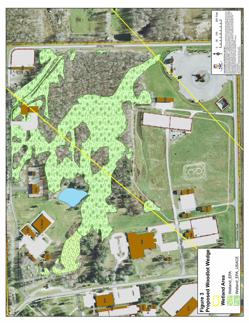
wetlands in the subject woodlot and to preserve and enhance the natural and beneficial values of the wetlands. The USAF stewardship responsibilities apply to the management of Federal lands and facilities as well as any Federal undertakings and activities that affect land use, including, but not limited to, water and related land resources planning, regulating, and licensing. Thus, the USAF initiated this environmental assessment (EA) to determine what action would be the most viable and least impacting for the FAA to address the radar coverage issue while ensuring that the USAF most effectively fulfills its legal obligations. This EA, therefore, discusses the proposed action of removing a wedge of the wooded wetlands at YARS. This EA has been performed in accordance with the National Environmental Policy Act (NEPA) of 1969, 40 Code of Federal Regulations (CFR), Part 1500, the Council on Environmental Quality (CEQ) regulations implementing NEPA, and the U. S. Air Force (USAF) Environmental Impact Analysis Process (EIAP) as established in 32 CFR 989. 1.2 Proposed Project YARS is located in the northeast section of Ohio, approximately 12 miles north of the City of Youngstown. The 230 acre base is adjacent to the Youngstown – Warren Regional Airport in Vienna Township, Trumbull County (Figure 1). The base is the home of the 910TH Airlift Wing of the U.S. Air Force Reserve which supports national objectives by providing mission-ready C-130 airlift forces, including a state-of-the-art aerial spray capability. This capability represents the only full-time, fixed-wing aerial spay mission in the Department of Defense. The base is also home to U.S. Navy and Marine Corps tenants. The significant woodlot at YARS, which is also the source of the radar screening, covers the less developed northeast sector of the base (Figure 2). This approximately 27 acre woodland, which is the largest block of undeveloped land at the base, contains an interconnected area of jurisdictional wetlands. The woodlot tree removal project would involve tree cutting within a wedge of the existing woodland tract. A boundary delineating the western margin of the critical radar coverage wedge (azimuth) from the YNG ATCT through YARS was surveyed and marked on the ground in the fall of 2008. All of the trees east of this boundary to Perimeter Road constitute the woodlot wedge as shown in Figure 3. The trees within the wedge, constituting approximately 20 acres of the woodlot, would be cut. Specifically, the tree canopy of the woodlot which generally occurs from approximately 50 to 70 feet above the ground needs to be cut. According to FAA analyses, the canopy leaves are primarily responsible for the radar screening (FAA, 2008) and a canopy cutting approach that results in improved coverage throughout the year might be acceptable (Goodrich, 2009).

00.5
10.2
5
MilesK Vicinit
y Loca
tionYou
ngstow
n Air R
eserve
Statio
n Gene
ral Pla
n
Ohi
oO
hio
Penn
sylv
ania
Penn
sylv
ania
New
Yor
kN
ew Y
ork
Wes
t Vi
rgin
iaW
est
Virg
inia Vi
rgin
iaVi
rgin
ia
Mic
higa
nM
ichi
gan
Ken
tuck
yK
entu
cky
Mar
ylan
dM
aryl
and
Cleve
land
Pittsb
urgh
Akron
Youn
gstow
n
Canto
n
§̈ ¦76
§̈ ¦80
§̈ ¦680
§̈ ¦76£ ¤322
£ ¤422
£ ¤62
£ ¤224
£ ¤62
£ ¤62
£ ¤224
Trum
bull
Porta
ge
Maho
ning
Geau
ga
Stark
Merc
er
Colum
biana
Asht
abula
Lawr
ence
Craw
ford
Beav
er
Lake
UV193
UV11
King G
raves
King G
raves
Ridge
Henn HydeFigur
e A
Figur
e B
Figur
e C
Figur
e C:
Figur
e B:
Figur
e A:
010
020
050
Miles
08
164
Miles
Cana
daLa
ke
Erie
Base
map D
ata So
urce:
ESRI
USA
Bas
e Map
2008
Figur
e 1Re
giona
l Loc
ation
_̂

540
540
517
517
504
504
539
539
F-902
8F-9
028
530
530
533
533
541
541
534
534
505
505
532
532
535
535
506
506
513
513
538
538
545
545
518
518
528
528
536
536
507
507
537
537
F-141
7F-1
417
531
531
F-141
7F-1
417
F-600
6F-6
006
529
529
F-600
6F-6
006
525
525
F-600
9F-6
009
Perimeter Road
Herriman Road
Marin
e Roa
d
Camp Road
Navy
Driv
e
Perim
eter R
oad
Perim
eter R
oad
Figur
e 2Pr
oject
Stud
y Area
Proje
cted C
leared
Wetl
and
Proje
cted C
leared
Fores
t
Wetla
nd Ar
eaWe
tland
_EPA
Wetla
nd_E
PA_U
SACE
Fores
t Man
agem
ent A
rea
010
020
050
Feet
K TH
IS DO
CUME
NT IS
FOR
OFFIC
IAL US
E ONL
Y.TH
IS MA
P/IMA
GE W
AS PR
ODUC
ED TH
ROUG
H THE
U.S.
DEPA
RTME
NT O
F DEF
ENCE
(DOD
) OFF
ICE O
F THE
UNITE
D STA
TES A
IR FO
RCE R
ESER
VE CO
MMAN
D (AF
RC) B
Y THE
YOUN
GSTO
WN AI
R RES
ERVE
STAT
ION,
CIVIL
ENGE
NERR
ING
DEPA
RTME
NT –
VIENN
A, OH
. ALL
IMAG
ERY I
S THE
SOLE
PROP
ERTY
OF T
HE U
NITED
STAT
ES G
OVER
NMEN
T AND
IS N
OT TO
BE R
EPRU
DCED
WITH
OUT T
HE CO
NCEN
T OF T
HE O
FFIC
E OF T
HEAF
RC, S
UCH A
N ACT
WILL
BE A
CLEA
R VIO
LATIO
N OF
U.S.
COPY
RIGHT
LAWS
. YOU
NGST
OWN A
RS CI
VILEN
GENE
RRIN
G DE
PART
MENT
SHAL
L NOT
BE LI
ABLE
FOR
ERRO
RS, O
MISS
IONS
OR
DAMA
GES T
HAT
RESU
LT FR
OM IN
APPR
OPRIA
TE US
E OF T
HIS D
OCUM
ENT.
THIS
DOCU
MENT
IS A
DRAF
T COP
Y AND
IS SU
BJEC
T TO
CHAN
GE.
11 De
cemb
er 20
08NA
D 198
3 STA
TE PL
ANE O
HIO FI
PS 34
01 FE
ETDA
TA SO
URCE
: YOU
NGST
OWN A
RS G
EOBA
SE
540
540
517
517
504
504
539
539
F-902
8F-9
028
530
530
533
533
541
541
534
534
505
505
532
532
535
535
506
506
513
513
538
538
545
545
518
518
528
528
536
536
507
507
537
537
F-141
7F-1
417
531
531
F-141
7F-1
417
F-600
6F-6
006
529
529
F-600
6F-6
006
525
525
F-600
9F-6
009
Perimeter Road
Herriman Road
Marin
e Roa
d
Camp Road
Navy
Driv
e
Perim
eter R
oad
Perim
eter R
oad
Figur
e 3Pr
opos
ed W
oodlo
t Wed
ge
Wetla
nd Ar
eaWe
tland
_EPA
Wetla
nd_E
PA_U
SACE
010
020
050
Feet
K TH
IS DO
CUME
NT IS
FOR
OFFIC
IAL US
E ONL
Y.TH
IS MA
P/IMA
GE W
AS PR
ODUC
ED TH
ROUG
H THE
U.S.
DEPA
RTME
NT O
F DEF
ENCE
(DOD
) OFF
ICE O
F THE
UNITE
D STA
TES A
IR FO
RCE R
ESER
VE CO
MMAN
D (AF
RC) B
Y THE
YOUN
GSTO
WN AI
R RES
ERVE
STAT
ION,
CIVIL
ENGE
NERR
ING
DEPA
RTME
NT –
VIENN
A, OH
. ALL
IMAG
ERY I
S THE
SOLE
PROP
ERTY
OF T
HE U
NITED
STAT
ES G
OVER
NMEN
T AND
IS N
OT TO
BE R
EPRU
DCED
WITH
OUT T
HE CO
NCEN
T OF T
HE O
FFIC
E OF T
HEAF
RC, S
UCH A
N ACT
WILL
BE A
CLEA
R VIO
LATIO
N OF
U.S.
COPY
RIGHT
LAWS
. YOU
NGST
OWN A
RS CI
VILEN
GENE
RRIN
G DE
PART
MENT
SHAL
L NOT
BE LI
ABLE
FOR
ERRO
RS, O
MISS
IONS
OR
DAMA
GES T
HAT
RESU
LT FR
OM IN
APPR
OPRIA
TE US
E OF T
HIS D
OCUM
ENT.
THIS
DOCU
MENT
IS A
DRAF
T COP
Y AND
IS SU
BJEC
T TO
CHAN
GE.
11 De
cemb
er 20
08NA
D 198
3 STA
TE PL
ANE O
HIO FI
PS 34
01 FE
ETDA
TA SO
URCE
: YOU
NGST
OWN A
RS G
EOBA
SE

Environmental Assessment Tree Removal to Improve FAA Radar Coverage 1-6
Thus, a range of possible cutting alternatives would potentially address the purpose and need for the project. These are addressed in Section 2.0. 1.3 Objective The objective of this EA is to support the interrelated decisions associated with the prospective FAA alternatives concerning the tree cutting project and to provide the decision maker and the public with information required to understand the short-term and long-term environmental consequences of the proposed action, alternative actions, and of no action as an alternative and to determine the significance of those actions. This EA provides a recommended action based on the Preferred Alternative as well as appropriate measures to mitigate any adverse effects and the determination of whether a Finding of No Significant Impact (FONSI) will be made if the potential impacts are not considered significant. 1.4 Regulatory Requirements The USAFR must comply with numerous statutes, regulations, and policy/instruction directives including the Code of Federal Regulations and Executive Orders. These are addressed, in part, through the EIAP and NEPA evaluation processes. Significant impact to jurisdictional wetlands would require compliance with Executive Order 11990 and a Section 401 Water Quality Certification from the OEPA and a Section 404 Wetlands Permit from the USACE. Mitigation requirements may be triggered by permits or procedural compliance. Appropriate project specifications may include these regulatory and/or mitigation requirements. Specifications for the proposed project will ensure that tree clearing or cutting activities avoid any circumstances that would trigger these compliance requirements.
Environmental Assessment Tree Removal to Improve FAA Radar Coverage 2-1
2.0 The Proposed Action and Alternatives 2.1 Introduction This section details the Proposed Action and the process used to formulate alternatives. A number of alternatives to the Proposed Action, in addition to the No Action Alternative, were identified and evaluated. 2.2 Process Used to Formulate Alternatives The NEPA process requires consideration of a full range of reasonable alternatives to the proposed action, including a no action alternative. The intention is to select an alternative that meets the underlying purpose, mission, or need of the proposed project, but which minimizes potential adverse environmental impacts and/or other negative consequences. Reasonable alternatives are those actions that may meet the purpose and mission for the project and deserve further analysis before choosing a course of action. The approximately 27 acre woodlot at YARS, as shown in Figure 2, is responsible for the radar screening affecting the YNG radar tower. There are no locational alternatives to improving the radar coverage as both the ATCT and the woodlot are fixed locations. The woodlot also contains jurisdictional wetlands which constitute both a site and operational constraint to any proposed action. The process employed to formulate project alternatives included an initial on-site evaluation of the woodlot by commercial loggers in 2008 and 2009. They determined that there was no mercantable timber in the woodlot; in fact, costs would be associated with cutting and removing the trees. Various YARS staff were consulted regarding project alternatives and finally, an on-site assessment of woodlot characteristics and possible alternatives was completed by Weston in October 2009. Characteristics assessed included tree size, shape, height, and woodlot density, as well as topography and wetland drainage. Project factors evaluated during this process included reasonableness/feasibility, cost effectiveness, safety, and avoidance of any compliance issues surrounding the wetlands. The evaluation process determined that the woodlot is an even-aged stand with trees primarily of the same age and size. Over 90% of the trees are above 50 feet in height with most being from 60-65 feet high. Virtually all of the tree canopies are above 50 feet height with the largest and tallest trees having the largest canopies. The tree stand is relatively dense and the tree boles are generally too small for climbing to heights far above the ground. There is insufficient space for large equipment, such as a lift, to move throughout the woodlot.

Environmental Assessment Tree Removal to Improve FAA Radar Coverage 2-2
Based on this evaluation, several potential operational tree cutting/clearing methods were deemed as unreasonable. These included any approaches utilizing bulldozing and stump removal (tree eradication). These methods would result in excessive ground disturbance with resulting likely grading, filling, and related impacts to the wetlands. Tree eradication through chemical treatment means was also considered to be unreasonable both because of potential wetlands contamination and because, in the long term, it is unnecessary. Tree regrowth is not an issue over the next approximately 15 years since the FAA plans to replace its current radar towers with NextGen (Next Generation Air Transportation System) technologies by 2025. Raising the existing tower would, therefore, not be cost effective. Although cutting the trees at a height between 35 to 50 feet (topping) would achieve the project purpose, this approach was deemed as impracticable due to the inability to use lift equipment, difficulty of scaling the trees, and safety and excessive cost concerns. Additionally, the remaining tree boles would be susceptible to disease, death, and windthrow. Thus, topping as an alternative was not considered further. Two feasible alternatives were identified as a result of the formulation process. The first alternative is clear cutting in which all of the trees in the woodlot wedge would be cut to stump level and removed. The second alternative is selective removal in which one-half to two-thirds of the woodlot would be removed. The selective removal could be achieved in a number of ways ranging from thinning to clear-cut plots or corridors. Both of these alternatives would accomplish the project purpose and both could be undertaken while employing the operational constraints. Since the selective removal alternative would preserve more of the woodlot and result in less overall environmental impact, it is the Preferred Alternative and Proposed Action. Lastly, the No Action Alternative was considered. Under the No Action Alternative, no woodlot clearing would occur. The No Action Alternative also serves as a baseline for comparative evaluation of potential environmental consequences. 2.3 Alternatives Eliminated from Further Consideration As discussed in Section 2.2, several alternative approaches/alternatives were deemed as unfeasible and are not considered further. The Proposed Action and the Clear Cutting Alternative were designated as the only reasonable alternatives for evaluation. No other significant action or operational alternatives were deemed as reasonable for evaluation in this EA. As required by NEPA, the No Action Alternative was also designated for evaluation.

Environmental Assessment Tree Removal to Improve FAA Radar Coverage 2-3
2.4 Description of Alternatives Considered 2.4.1 Clear Cutting Alternative This alternative would include the cutting of all trees to stump level at or near the ground in the major woodlot in the northeastern section of the base (Figure 2). The area to be cut consists of approximately 20 acres. The locational relationship of the cut area to the overall woodlot is shown in Figure 3. This alternative is described in detail below. 2.4.1.1 Clear Cut Tree Removal This alternative includes the clear cutting of approximately 20 acres of the woodlot in the northeast section of the base in order to remove the radar signal screening obstruction for the YNG ATCT. The tree cutting could be accomplished utilizing a variety of methods and equipment employed by commercial loggers. These range from manual chain saw felling and log skidding to shear cutters and log grapplers and trailers. Small woody material would be wood chipped and disposed of off base or otherwise removed from the woodlot. Much of the woodlot also contains jurisdictional wetlands which will be preserved (Figure 3). Grading and/or fill placement including organic fill (tree debris) cannot occur in the jurisdictional wetlands as required by USAF compliance with the Clean Water Act and EO 11990. Rutting and/or displacement of soils by equipment used in the wetlands must be avoided. This alternative as well as the Proposed Action shall be accomplished when the soils would be least vulnerable to equipment rutting; i.e. during the winter with frozen soil conditions or in late summer with no free water in an unlined auger hole within 18 inches of the soil surface. In winter, it is preferred that there is little or no snow to insulate the soils. Thus, the trees would be cut and salvaged as feasible, but the stumps, shrubs, and saplings will remain. The tree cutting would occur within the yellow line wedge as shown on Figure 3, essentially from the western yellow boundary, east to Perimeter Road. This yellow boundary line has been surveyed to reflect the radar wedge bearing that offers the most benefit for enhanced low altitude YNG ATCT radar coverage. The boundary has been marked in the field for reference. 2.4.2 Proposed Action: Selective Tree Removal The Proposed Action consists of tree cutting within the woodlot wedge, but in a selective rather than clear cut manner. The objective of the proposed Selective Tree Removal Alternative is to thin the woodlot, and thereby, reduce the radar screening tree canopy by one-half to two-thirds. This canopy reduction would

Environmental Assessment Tree Removal to Improve FAA Radar Coverage 2-4
likely reduce the screening interference sufficiently to allow the desired radar coverage improvement (Goodrich, 2009). If additional radar coverage was required, further thinning could be undertaken. The Proposed Action thinning could be accomplished in a number of ways. The first would be to selectively log all of the larger diameter trees, e.g. greater than 15 inch diameter breast high (dbh). This method would insure removal of all of the largest tree canopies. Other tree thinning options would include clear cutting a number of plots throughout the woodlot or cutting a number of corridors through the woodlot similar to utility or fire-break corridors. In both cases the clearing would total the desired one-half to two-thirds thinning. The method with the least potential impact to the wetlands and, therefore, the preferred approach, would be to leave wooded plots that are coincident with the jurisdictional wetlands to the extent possible. The wetlands comprise approximately 7 acres or just over one-third of the woodlot wedge. The Proposed Action allows significant flexibility in the selective thinning of the woodlot. With the assistance of a professional forester, a selective removal plan would be developed that would not only meet the project purpose, but also allow for maximum protection of the jurisdictional wetlands and woodlot aesthetic values. The same operational constraints as with the clear cut alternative, however, would apply as required mitigation for the Proposed Action. 2.4.3 No Action Alternative Under the No Action Alternative, no tree removal would occur. Existing conditions would remain and operations would continue under current limitations. The woodlot would continue to create a radar screening problem affecting the YNG new Airport Surveillance Radar System (ASR-11). The ongoing safety risks and FAA flight operation problems stemming from the radar screening would continue. All low level flights emanating from the northeast would be negatively affected. This alternative also serves as a baseline against which the Proposed Action and the Clear Cutting alternatives will be evaluated and compared. 2.5 Summary Comparison of Alternatives Section 3 of this EA describes environmental features pertinent to the Project Area and alternatives analysis. Section 4 details the anticipated potential impacts of the Proposed Action and each alternative. This section presents a brief comparison of those impacts. Resource areas with no potential impact are not included in this comparison. Potential environmental impacts are classified and described by numerous terms referring to the outcome (beneficial/adverse or negative), duration (short-term/long-term), mode (direct/indirect), and magnitude and/or severity of the action being analyzed. Magnitude and severity of impacts are generally

Environmental Assessment Tree Removal to Improve FAA Radar Coverage 2-5
described as significant, major, minor, minimal or nominal, and negligible. Significant impacts generally result from substantial effects to resources or values associated with important, critical, protected, and or controversial concerns. Minor impacts are serious, relevant, and measurable, but with mitigation, do not reach the level of major or significant. Minimal or nominal impacts are measurable and relevant, but limited in area, effect, and/or duration. Negligible impacts are inconsequential with conditions remaining essentially unchanged. 2.5.1 Clear Cutting Alternative This alternative would result in the temporary to semi-permanent loss of approximately 20 acres of natural area, mostly medium to low value woodland. This would result in a major change to the aesthetic character of the northeast section of YARS. Minor impacts would also occur to other vegetation, wildlife, and land use. Long term impacts to health and safety, air quality, and noise would be negligible with mitigation. Short term nominal to minor impacts would affect surface waters, air quality, and noise. Implementation of Best Management Practices and other mitigation measures, as stipulated above for protection of the jurisdictional wetlands, would reduce potential impacts and prevent minor to potentially major impacts from becoming more adverse. The Clear Cutting Alternative would eliminate the potential health and safety impacts associated with the woodlot radar screening problem. 2.5.2 Proposed Action: Selective Tree Removal The Proposed Action would have essentially the same types of impact as the Clear Cutting Alternative, albeit at a reduced scale. Only 10 to 13 acres of the woodlot would be cut and the flexibility exists to allow more avoidance of and protection for the wetlands as well as greater preservation of woodland aesthetics. Other potential impacts from surface runoff to air quality would be similarly lessened. The Proposed Action would also be potentially more beneficial for certain wildlife species. The same mitigation requirements would apply. The Proposed Action would also eliminate the radar screening problem. 2.5.3 No Action Alternative The No Action Alternative would result in on-going safety risks and inefficient operations for the FAA at YNG. The safety and flight operation problems associated with the ATCT radar screening obstruction would continue, specifically for all low level flights emanating from the northeast.

Environmental Assessment Tree Removal to Improve FAA Radar Coverage 2-6
2.5.4 Preferred Alternative The Proposed Action best meets the objective of removing the radar screening obstructions in a safe and least-impacting manner. The Proposed Action would result in only minor impact after mitigation. This alternative best balances the objective of eliminating or reducing the radar screening issue until the FAA employs NextGen technology while ensuring that the USAF best fulfills its role as steward of the wetlands at YARS. Consequentially, the Proposed Action is recommended as the Preferred Alternative.

Environmental Assessment Tree Removal to Improve FAA Radar Coverage 3-1
3.0 Affected Environment 3.1 Introduction This section describes the environment of the Project Study Area and specific associated geographic area, such as the base or region, that would be potentially affected by the Proposed Action and alternatives. This section also provides the background information and a basis for the analysis of environmental impact in Section 4.0. The primary Project Study Area is outlined in Figure 2. 3.2 Biological Resources
3.2.1 Vegetation Vegetation in the Project Study Area consists of an approximately contiguous 27 acres of mixed northern hardwoods and additional, relatively open areas characterized by individual or small clumps of trees, shrubs, forbs, and grasses. The woodland, which covers part of the Proposed Action location, is characterized by a relatively young, even-aged stand of red maple (Acer rubrum) [U.S. Air Force Reserve Command, Integrated Natural Resources Management Plan (INRMP), 2003]. This woodland type, including age and species, reflects both the prior land disturbance and poor drainage of the area [Engineering Environmental Management, Inc. (E2M), 2002]. The woodlot was further field-analyzed in October, 2009 during which canopy heights and tree density and other characteristics were assessed. Tree heights were measured with an Abney level. Over 90% of the trees exceed 50 feet in height, most between 60-65 feet. Larger specimen trees to 36 inch dbh are scattered throughout the woodland, although most are smaller. These include sugar maple (Acer saccharum) American beech (Fagus grandifolia), and red oak (Quercus rubra) on more upland areas and red maple, green ash (Fraxinus pennsylvanica), and tulip tree (Liriodendron tulipifera), and poplars/cottonwood (Populus spp.) in wetter areas. Scattered white pine (Pinus strobus) are found near the margins of the woodland, particularly around the small pond at the northwest margin of the woodland. Scattered shrubs including dogwood (Cornus spp.) and spicebush (Lindera benzoin) and northern arrowwood (Viburnum recognitum) characterize the understory. Photographs depicting the general characteristics of the location are included in Appendix A.

Environmental Assessment Tree Removal to Improve FAA Radar Coverage 3-2
3.2.2 Wildlife The fauna found in the Project Study Area include species commonly found in similar habitats in this part of Ohio. Mammals could include deer, fox, raccoon, opossum, skunks, rabbits, groundhogs, squirrels, and chipmunks. Amphibians include toads, frogs, and salamanders. A wide range of birds from Canada geese to common song birds are found within and near the Project Study Area. According to the U.S. Fish & Wildlife Service (USF&WS, 1995), the woodlot itself is too small to support neotropical forest nesting birds, but it may be of value to other species including migratory birds. Similarly, the habitat is too restricted to support hunting or trapping. Base fencing typically restricts deer from entry. The woodlot and surrounding area does provide moderate habitat for song birds, limited habitat for amphibians, and the small pond supports warm water fish including bass and bluegill (e2M, 2002). Habitat enhancement that might attract birds is discouraged by the installation BASH (Bird Aircraft Strike Hazard) program which seeks to eliminate the potential for bird activity near the active flightline (Harland Bartholomew & Associates, 2005). 3.2.3 Threatened and Endangered Species Compliance with Air Force Policy Directive (AFPD) 32-70, Environmental Quality, and AFI 32-7064, Integrated Natural Resource Management Plan (INRMP), requires all Air Force properties to protect species classified as endangered or threatened under the Endangered Species Act of 1973 (ESA) and to comply with State of Ohio Law 1531.25 and its implementing regulations for species listed by the state as threatened and endangered (T&E). To comply with these requirements, YARS conducted a Threatened and Endangered Species Survey in 1996 (Parsons Engineering, 1996). No T&E species were identified on the installation and none are known to occur in the vicinity. YARS is located within the range of several T&E or special status species including the Indiana bat (Myotis sodalis), bald eagle (Haliaeetus leucocephalus), eastern massasauga rattlesnake (Sistrurus c. catenatus), and clubshell (Pleurobema clava, a mussel). The eastern massasauga rattlesnake is a federal candidate species usually found in wet areas including wet prairies, marshes, and low lying areas. No suitable habitat exists in the specific Project Study Area according to U.S. Fish & Wildlife Service (op. cit., 1995). Similarly, no habitat exists in the vicinity for the bald eagle or clubshell. Copies of correspondence with the Ohio Department of Natural Resources (ODNR) and the USF&WS regarding the potential occurrences of threatened and endangered species and other natural features in the Project Study Area are provided in Appendix A. The ODNR indicated that it had no records of rare or

Environmental Assessment Tree Removal to Improve FAA Radar Coverage 3-3
endangered species, no natural preserves, no unique ecological sites, or any breeding animal concentrations within one-half mile of the Project Study Area. The USF&WS had indicated that the Project Study Area woodlot may contain trees that provide summer habitat for the Indiana bat and requested further coordination before cutting of trees on the site. The concern was for specific trees that may serve as maternity brood or roost trees for the bat. These are typically trees with exfoliating bark or snags with peeling bark and cavities. The USF&WS requested a field survey for such trees and implementation of mitigation as appropriate. Weston conducted a field survey of the Project Area woodlands on 12 June, 2006 to identify any potential Indiana bat brood or roost trees. Eight potential habitat trees were identified and marked with spray paint. Only one of the trees, a 40 inch dbh maple, was characterized by favorable bat habitat conditions. The other seven trees were smaller with only marginal exfoliating bark. These trees were removed prior to April 15, 2009 as a mitigation measure to ensure no impact to potential habitat trees during the bat nesting season. 3.2.4 Wetlands A comprehensive wetlands survey of YARS was conducted in 2001 and 2002 (e2M, 2002). The survey, utilizing the official 1987 U.S. Army Corps of Engineers (ACE) methodology, identified 12.46 acres of ACE jurisdictional wetlands and 0.89 acres of isolated wetlands regulated by OEPA. Nearly all of these wetlands are located in the Project Study Area. Approximately 0.5 acres of the ACE wetlands were recently filled due to construction of Building 539, the new munitions maintenance facility (Figure 3). The wetlands were field delineated and categorized for functional and ecological value according to OEPA’s Ohio Rapid Assessment Method (ORAM). This method facilitates protection of wetlands by comparative assessment of potential impact according to the value class of the wetlands. The most valuable wetlands are Category 3 with Category 2 and Category 1 wetlands possessing lesser wetland function and ecological values, respectively. The entire wetland complex is located in the northeast section of the base, mostly within the Project Study Area (Figure 2). The wooded wetlands occupy most of the central portion of the approximate 27 acre contiguous woodland. The wetlands are characterized primarily by the red maple overstory and other vegetation as described in Section 3.2.1. The location of the wetland tree removal project coincides with approximately 50% of the YARS jurisdictional wetlands. Primary functions of the wetlands include moderate storm water storage and song bird habitat, along with limited amphibian reproductive habitat. None of the

Environmental Assessment Tree Removal to Improve FAA Radar Coverage 3-4
wetlands have unique or unusual features. All of the jurisdictional wetlands are Category 1 or Category 2 wetlands according to ORAM scoring. The Category 2 wetlands have moderate ecological values. These wetlands have no threatened or endangered species, no significant habitat or wildlife use, and relatively low species diversity. Category 1 wetlands have minimal ecological values. Some characteristics of the wetlands are depicted in the photographs of the Project Study Area in Appendix A. As wetlands are regulated under various statutes including Section 404 of the Clean Water Act, OAC 3745-1-54, Wetlands Anti Degradation and OAC 3745-32, Section 401 Water Quality Certification, and Executive Order 11990, Protection of Wetlands, YARS must comply with the regulatory requirements before implementing any actions which may impact the wetlands. Under Secretary of the Air Force Order 780.1, issued in April 1991 and embodied in AFI 32-7064, a Finding of No Practical Alternative (FONPA) must be approved by a properly designated official before any action is undertaken in the Federal wetlands. 3.3 Water Resources 3.3.1 Groundwater Groundwater at YARS is closely related to the underlying geology. Located within the glaciated Allegheny Plateau, groundwater is found in both the glacial gravels, till, and sand deposits as well as the bedrock formations. The glacial substrate is irregularly distributed across the base, ranging from very shallow deposits to depths of over 100 feet. Accordingly, no significant groundwater aquifers are associated with these glacial deposits. Groundwater is seasonally near the surface over much of the Project Study Area, in part due to numerous perched water tables which contribute to the hydric soil and wetland conditions. Principal groundwater resources are associated with Pennsylvanian age sandstones of the Pottsville Formation at depths of less than 100 feet to over 300 feet. The aquifer is confined and average yields are about 10 gpm. Mississippian age shales and sandstones of the Cuyahoga Group also provide groundwater at less than 200 feet bgs with yields of 10gpm (U.S. Department of Agriculture, 1992). No sole source aquifers under XX USC 1424(e) of the Safe Drinking Water Act are found on or near YARS. 3.3.2 Surface Water YARS is located near several drainage divides, but within the Ohio River Basin. Most installation storm water drains westerly to intermittent streams flowing to Spring Run which discharges to Mosquito Creek and, ultimately, the Mahoning
Environmental Assessment Tree Removal to Improve FAA Radar Coverage 3-5
River. A northeast section of YARS drains to the southeast through intermittent streams, ultimately reaching the South Branch of Yankee Run, which drains to the Shenango River in Pennsylvania. The small pond in the Project Study Area outlets to this drainage. Other than the small pond (less than one acre), there are no significant surface water features on base. Storm water flows overland, through culverts, and drainage ditches to five outfalls. Three of the outfalls are piped, while two are overland flow and/or intermittent channels. The installation is covered by a State of Ohio General Storm Water Permit for Industrial Activity. As required by the permit, the installation Storm Water Pollution Prevention Plan (SWP3) includes Best Management Practices (BMPs) to prevent pollution, principally from aircraft deicing and snow/ice control. The installation Sustainability Action Plan calls for management activities to encourage groundwater recharge and the INRMP includes provisions to prevent erosion and sedimentation to the wetlands. Storm water runoff from construction activities can impact water quality by contributing sediment and other pollutants exposed at construction sites. The National Pollutant Discharge Elimination System (NPDES) Storm Water Program, Phase II rules, addresses construction activities that disturb one acre or more of land. Youngstown ARS applies for coverage under OEPA General Permit No. OHC000003 Authorization for Storm Water Discharges Associated with Construction Activity for disturbances that exceed one acre. Trumbull County Soil and Water Conservation District (SWCD) must approve an Erosion and Soil (E&S) Control Plan for each coverage under OEPA Permit OHC000003 prior to construction and perform regular inspections on these projects. 3.3.3 Floodplains As there are no significant streams on or adjacent to YARS, there are no officially designated floodplains in the vicinity. The various intermittent channels and drainage ditches on the installation are managed as part of the storm water system. 3.4 Installation Restoration Program (IRP) There are five IRP sites at YARS [Harland Bartholomew & Associates (HBA), 2005]. The five IRP sites include former drum storage and transformer storage areas, a waste oil/solvent corral, a POL/lead sludge disposal area, and a fuel line leak area. All of these sites have been studied under the IRP and all are now closed with No Further Action (NFA) determination status (YARS, 2006, 5). Only one site, the former drum storage area (SS-01), is near the Project Study Area.

Environmental Assessment Tree Removal to Improve FAA Radar Coverage 3-6
3.5 Soils The U.S. Department of Agriculture, Natural Resource Conservation Service (NRCS) soil survey of Trumbull County (USDA, 1992) has identified six soil series at YARS. Most of the installation is characterized by Udorthent soils – those that have been cut or filled with a wide range of soil properties. This reflects the highly developed nature of the base. The Project Study Area, however, is dominated by two soil series, the Rawson and the Haskins, with minor areas of Wadsworth and Mitiwanga. The characteristics of these soils are important because of their relationship to the wetlands and vegetation of the area. Rawson soils, formed on loamy sediments and glacial till, are moderately well drained with moderately slow to very slow permeability. An intermittent perched water table occurs between 2 to 3.5 feet depth. This soil is non-hydric, but has hydric components. The Haskins soils are deep, poorly drained soils formed on glacial till with a seasonal perched water table at 0.5 to 1.5 feet depth. Permeability varies from moderate in the upper loamy lenses to very slow in the deeper clayey lenses. This soil is non-hydric, but has hydric components. The other two soil series were also formed primarily on till and are somewhat poorly drained. The Wadsworth soil has a fragipan (nearly impervious lens) at 18 to 30 inches depth with slow to very slow permeability. The Mitiwanga soil has a seasonal high water table at 6 to 12 inch depth. 3.6 Land Use YARS encompasses approximately 230 acres, most of which consists of improved land committed to military activity and airport support operations. An additional 91 acres of land are leased from the Youngstown-Warren Regional Airport Authority for assault runway use. The developed areas of YARS include buildings and structures committed to administrative, aircraft and airfield operations, maintenance, civil engineering, and personnel and mission support activities. A network of roads, parking areas, and walkways, as well as aircraft aprons, connects the various structures. Undeveloped or open space areas are primarily limited to the far eastern section of the base. Land uses abutting the base include the airport to the southeast, south, and southwest; some rural residential properties to the east; and primarily agricultural or woodland areas to the north and northwest. A comprehensive General Plan for YARS was issued in 2005 (HBA, 2005). The plan provides a detailed assessment of current and future land uses, and issues associated with both. The plan also provides a vision for development of the

Environmental Assessment Tree Removal to Improve FAA Radar Coverage 3-7
base including supplying mission-critical facilities, meeting “Force Protection” standards, creating a pedestrian-friendly place to train, and for achieving sustainability goals. A framework for future development and mission expansion improvements is detailed over an approximate seven-year horizon. The plan categorizes installation Open Space as either developable or as natural resource preservation. Current land use at the Proposed Action location is Open Space. The Proposed Action location is located in natural resource preservation Open Space, which reflects the existing woodland/wetland land cover. Explosive safety zone or quantity/distance restrictions (ESQDs) are associated with Buildings 533, 537, and 539 in the existing munitions complex. These 100-foot arc constraint zones extend partly into the Proposed Action location, which presents an IL site issue for this part of the base. The entire Project Study Area lies beyond the 65 dB (decibel) noise contour surrounding airfield operations. 3.7 Cultural Resources According to the YARS Cultural Resources Contingency Plan (U.S. Air Force Reserve Command, 2001), four different surveys have been conducted on the installation over the years to identify either historic or prehistoric resources. The most significant of these surveys are the 1995 basewide Phase I historic building survey and the 1995 Phase I archaeological survey by Resource Applications Inc. (RAI, 1995). In 1989, archaeological maps at the Ohio Historical Society were reviewed by Mr. James Murphy, a state certified archaeologist. No known archaeologic sites were found on or near the base. An update of the 1995 historic building survey was recently completed (Historic Preservation Associates, 2009). This recent survey evaluated all of the installation buildings and significant structures with a particular focus on their “Cold War” status. Only the installation water tower was determined to be potentially eligible for listing in the National Register of Historic Places. Based on these studies, no historic or prehistoric resources are known to exist at YARS. Coordination applicable to the Proposed Action and alternative locations and any potential cultural resource implications was completed with the State Historic Preservation Office (SHPO) as part of the EA prepared for the construction of the Munitions Maintenance Facility, Building 539. Coordination response indicating general concurrence with the lack of cultural resources was received in April, 2006. The correspondence is included in Appendix A. 3.8 Air Quality The Clean Air Act Amendments of 1990 (CAAA) tasked the USEPA with generating a revised set of rules governing the establishment of air quality standards and rules governing emissions of pollutants. The National Ambient Air

Environmental Assessment Tree Removal to Improve FAA Radar Coverage 3-8
Quality Standards (NAAQS) set concentration levels for the following pollutants, often referred to as “criteria air pollutants”: carbon monoxide (CO), nitrogen oxides (NOx), sulfur dioxide (SO2), lead, ozone (O3; note: emissions of volatile organic compounds or VOCs are regarded as precursors of ozone), and particulate matter equal to or less than 2.5 microns in diameter (PM2.5). Lead is also regulated as a hazardous air pollutant (HAP). Air quality issues associated with the Proposed Action are primarily related to the potential generation of pollutants during clearing activities and fugitive emissions from vehicles. Air quality is typically good in the vicinity of YARS, and is generally affected only locally by military and civilian vehicle emissions, particulate pollution from vehicle traffic, industrial sources, and construction activities. Mobile sources such as vehicle and aircraft emissions are generally not regulated and are not covered under existing permitting requirements. Specific emissions sources at YARS include natural gas boilers, fuel cell maintenance, engine test stands, paint spray booths, refueling operations, and emergency power generators. YARS is located in Trumbull County in the Youngstown-Warren Metropolitan Statistical Area (MSA) which is currently designated as maintenance for the 8-hour ozone standard. The county is in attainment for the other criteria pollutants. The designation results in a requirement for an air quality conformity applicability analysis for Federal actions to determine whether or not Conformity Rules apply. Applicability hinges on emission increases from the action or exceedence of de-minimus emissions of criteria pollutants. YARS prepares an annual base-wide Air Emissions Inventory Report that covers all operations for the previous year. This activity includes an emissions inventory of all potential installation emission sources and an analysis of the applicability of governing regulations. The status of each source type is assessed. YARS is exempt from Title V of the CAA Amendments of 1990 since potential emissions are below major source thresholds. Most of the installation sources are de minimus. There are five air sources currently on OEPA registration status. Emergency generators and emergency fire pumps with internal combustion engines greater than 50 HP fall under permit-by-rule exemptions which require record keeping. 3.9 Noise Noise levels associated with YARS operations can create conflicts related to activities both on and off the base. Flight activities at YARS that contribute to the noise environment include the 910th Airlift Wing and the aircraft operations of the Youngstown-Warren Regional Airport. Flight operations of the 910th Airlift Wing include the missions of the 12 assigned C-130 aircraft as well as transient aircraft such as C-130s utilizing the installation’s engine repair facility. Limited
Environmental Assessment Tree Removal to Improve FAA Radar Coverage 3-9
commercial airline service is currently available at the airport, with primarily chartered and general/corporate aircraft utilizing the facility. Noise levels can be considered in terms of levels ranging from those in a typical home at 40dB, to levels at which noise begins to harm hearing when exposed for a long period (8 hours) at 90dB. Typical noise sources in and around the Project Location include aircraft, active use of the firing range, and traffic. Military aircraft operations and vehicle traffic are the existing primary sources of noise in the Project Study Area. A Federal Aviation Administration Part 150 Study established the 65dB LDN (day-night average sound level) noise contour around the airfield in 1993. Virtually all of YARS, including the Project Study Area, lies outside this noise threshold boundary. This noise level represents existing conditions to which potential noise levels from construction and demolition can be compared. 3.10 Health and Safety General health and safety issues associated with the Proposed Action include worker safety and public safety during clearing operations as well as recognition of the ESQDs associated with the existing munitions complex. Occupational and public safety issues are addressed with respect to site clearing and tree cutting activities. Short-term health and safety issues for the Proposed Action include hazards from site clearing activities associated with logging and tree cutting operations. Such hazards include physical hazards (including heavy and light on-site equipment usage, power tools, noise), hazardous materials, and underground/ overhead utility work. Additionally, the current radar screening issue associated with the YARS woodlot presents a safety threat for low level flights at YNG emanating from the northeast. Two ESQDs are associated with Buildings 533 and 537 respectively, which adjoin the Proposed Action location. These zones could affect site clearing activities. 3.11 Socioeconomics YARS is located within the Youngstown-Warren MSA, which includes Mahoning and Trumbull Counties in Ohio and Mercer County in Pennsylvania. The region grew steadily with population peaking in the 1970s at over 600,000 inhabitants (U.S Census Bureau, 2000). The population of Youngstown, the region’s largest city, actually peaked in 1960 at 167,000. With the decline of the steel industry, an economic mainstay of the region into the 1970s, and more recently, manufacturing in general, the region has endured

Environmental Assessment Tree Removal to Improve FAA Radar Coverage 3-10
declines in numerous socioeconomic indicators. Population of the MSA in 2000 was 602,964, a decline from 613,623 in 1990. The population is projected to fall to 571,000 by 2020 (Ohio Department of Development, 2005). Trumbull County, which includes the City of Warren and YARS, has followed a similar population trend reaching a peak of 241,863 in 1980, decreasing to 225,116 in 2000, and projected to decline to 211,000 by 2020 (Ohio Department of Development, 2005). The regional population declines over the last several decades, as well as the projected future declines, are principally related to the loss of manufacturing jobs in the region. Nationally, employment in the iron and steel industry alone dropped from 399,000 in 1980 to 169,000 only nine years later (U.S. Statistical Abstract). More than 3 million U.S. manufacturing jobs were lost between 1998 and 2003 (Economic Policy Institute, 2005), and this trend has continued statewide. In the context of regional decline, the importance of YARS as both a major and relatively steady employer is evident. The base was listed as one of only five employers in the Youngstown-Warren area with more than 2,000 employees in 2005 (Youngstown-Warren Regional Chamber of Commerce, 2005). Of the other four, two were hospitals/health care providers and two were associated with the automotive industry – Delphi Packard Electric Systems and General Motors Lordstown Assembly. Delphi has recently begun to emerge from its bankruptcy reorganization and its Warren-area plants remain operational, although at reduced employment levels. Some production jobs are in the process of being transferred from a closed Delphi plant in Mississippi to Warren (www.cleveland.com/business, 2009). Similarly, General Motors has recently emerged from bankruptcy reorganization with the Lordstown plant remaining open, but with variable levels of employment. Nine other employers were listed by the Chamber of Commerce in 2005 as having from 1,000 to 2,000 employees; all but two of these are governmental or educational institutions. Another 19 non-governmental employers were listed with 500 to 1,000 employees including seven manufacturing operations. As of September, 2004, YARS had 2,239 authorized personnel positions including over 1,100 USAF Reservists (YARS Fact Sheet). These base jobs generate a payroll of over $50 million. When combined with local base expenditures of over $28 million and a more than $17 million payroll from indirect job creation, the economic impact of the base is more than $95 million annually. Clearly, the ongoing mission and operations of YARS is of vital socioeconomic importance to the region. Similarly, the Youngstown-Warren Regional Airport is considered important to the economic well-being of the region. The Western Reserve Port Authority (WRPA) operates the airport and in conjunction with the Youngstown-Warren Regional
Environmental Assessment Tree Removal to Improve FAA Radar Coverage 3-11
Chamber of Commerce plays a leading role in economic development. During 2008, YNG had 60,845 aircraft operations, an average of 166 per day. Of these, 59% were general aviation and 38% were military (Wikipedia, 2009). Commercial service was recently restored with scheduled flights to and from Orlando, Florida. 3.12 Transportation/Traffic YARS is served by a network of highways that allow ready access to the base. These include Ohio State Routes 11 and 193. From these routes the base is accessed by King Graves Road, a county road. The General Plan has recommended changes to the YARS road alignment and gate access configurations in order to improve force protection and to reduce potential traffic congestion. On base, circulation is hampered by the lack of a clear hierarchy for the roads, lack of pedestrian connections, and an inefficient location of parking. Force protection issues are common. 3.13 Utilities YARS is currently served by all major utilities including potable water, sanitary and storm sewers, electricity, natural gas, and communications. All of the systems have been rated as adequate, with most of the infrastructure in very good condition (HBA, 2005). The lone exception is the storm water drainage system which has inadequate drainage in some locations. Potable water is supplied to YARS by Trumbull County’s Southeast Water District and sanitary is provided by the County’s Mosquito Creek Sewer District. Both systems have adequate capacities. YARS also has an industrial wastewater collection system and an industrial pre-treatment facility in Building 309 that discharges into the sanitary system. Electricity is provided by Ohio Edison which also has responsibility for the on-base distribution system. Natural gas is supplied by Dominion Gas to a tap at the base perimeter. Most of the base buildings have independent gas heat sources. Both the electricity and gas systems are in need of force protection upgrades according to the General Plan. The base fire department is integrated with the local emergency and HAZMAT response system. Solid waste services at YARS are contracted out with disposal at a licensed landfill.

Environmental Assessment Tree Removal to Improve FAA Radar Coverage 4-1
4.0 Environmental Consequences 4.1 Introduction The purpose of this section is to provide an evaluation of the potential impact associated with the Proposed Action, selective tree removal in the wooded wetland area. The consequences of implementing the Proposed Action and the Clear Cutting Alternative are compared with each other and the No Action Alternative, which represents the baseline conditions. Mitigation measures, particularly with respect to scheduling logging operations in the dry fall or winter period as discussed in Section 2, are common to both action alternatives. 4.2 Biological Resources
4.2.1 Vegetation 4.2.1.1 Clear Cutting Alternative The approximately 20 acre wooded tract described in the Proposed Action would be cleared under this alternative. This tract is characterized by wooded wetlands. The vegetation includes specimen trees up to 36 inches dbh along with understory shrubs, forbs, and wild flowers. Figure 3 depicts the proposed clearing wedge of the woodland, as well as adjoining land use and vegetative cover. The proposed tree clearing would involve the entire 20 acres between the FAA wedge western boundary, shown as a yellow line on Figure 3, and Perimeter Road on the north and east. This alternative would result in the clearance and removal of all 20 acres of the red maple woodland and some understory. Mitigation already completed consisted of removal of potential bat habitat trees prior to 15 April, 2009, as required by coordination with the USF&WS, to ensure no impact to Indiana bat habitat trees, at least during the nesting season. With this alternative, the potential vegetation loss would represent a major, relatively long-term impact to the existing approximately 27 acre woodland area of the base. However, the tree stumps would remain in the wetland tree clearing area and the associated natural area would remain. Many of the stumps would sprout new growth which would cover the area within several growing seasons. Shrubs would also respond with vigorous growth as would sapling trees. The opportunity for unwanted vegetation growth, specifically invasive species like Chinese honeysuckle (Lonicera spp.), would be facilitated by clear cutting the woodlot. Loss of the trees would result in less evaportranspiration which would result in wetter soil conditions and more surface water. Similarly, loss of the whole woodlot wedge would greatly alter the woodland aesthetics of YARS and the neighborhood to the east. The woodland would become an open, brushy area. Loss of the woodlot, while substantial and significant to the installation, would
Environmental Assessment Tree Removal to Improve FAA Radar Coverage 4-2
represent only a very small and insignificant percentage of the local area forests; thereby resulting in only minimal overall impact. 4.2.1.2 Proposed Action: Selective Tree Removal Under the Proposed Action, the entire 20 acre woodlot wedge would be cut or logged as with the Clear Cutting Alternative, but in a selective manner that would remove only one-half to two-thirds of the stand. This Preferred Alternative is flexible as to how the density reduction of the woodlot tree canopy is accomplished. Smaller trees could be left intact. Tree clumps or islands, rows of trees or some combination thereof, would remain. This flexibility would potentially allow for less disturbance to the wetland vegetation and greater opportunity for retention of aesthetic values. The Proposed Action would still result in a major loss of the woodlot canopy cover. This would represent a lesser impact to vegetation than the Clear Cutting Alternative. Parts of the current forest environment complete with its understory would remain. 4.2.1.3 No Action Alternative No vegetation would be affected by the No Action Alternative. 4.2.2 Wildlife 4.2.2.1 Clear Cutting Alternative The Clear Cutting Alternative would result in a change in the type of habitat existing in the wetland tree removal wedge. Coordination with the ODNR and the USF&WS indicated the lack of any critical habitat or sites of significant ecological value at YARS or in the surrounding vicinity. Use of heavy equipment for the tree removal has the potential to impact wetlands habitats depending on the season when the work is done. Similarly, the loss of shade canopy would somewhat alter the nature of the wetlands, which might affect some species. Potential impacts to wildlife include the loss or modification of vernal pools and other wetland areas that are of value to the less mobile amphibian species. Loss or modification of the jurisdictional vernal pools and other wetland areas are prohibited without regulatory permits. Project specifications will require wetlands protection as discussed under required mitigation in Section 2. This loss or modification of vernal pools and other wetland areas shall be prevented by careful tree removal procedures and seasonal timing of the work (see Wetlands). Some bird habitat would be lost; however, nesting birds or other nesting wildlife would not be affected since mitigation will restrict work to the dry fall or winter seasons. More mobile wildlife, including the common mammals and birds, would be expected to move from the disturbed areas to adjoining undisturbed areas.
Environmental Assessment Tree Removal to Improve FAA Radar Coverage 4-3
With mitigation, the impacts to wildlife are expected to be minor. Short-term, temporary impacts to wildlife would also result from tree removal activities, particularly forest dependant species. No long-term impact to any specific wildlife species is expected. 4.2.2.2 Proposed Action: Selective Tree Removal Potential impact to wildlife under the Proposed Action would be similar to, but less than, that of the Clear Cutting Alternative. Most of the tree canopy would be removed with similar results. However, sections of the existing woodlot would remain essentially intact and overall, more wildlife habitat would be preserved. With selective thinning, the juxtapositioning of forest environments with more open, brushy environments, would create edge niches which are attractive to many species. 4.2.2.3 No Action Alternative Wildlife in the Project Study Area would not be impacted by this alternative. 4.2.3 Threatened and Endangered Species 4.2.3.1 Proposed Action No threatened or endangered species nor their habitats are known to exist in the Project Study Area or YARS vicinity. As discussed in Section 3.2.3, no such species nor their habitats have been identified. Correspondence with ODNR also indicated the lack of any records of such species in the area surrounding the installation. Correspondence with the USF&WS, however, indicated that the Project Study Area lies within the range of several special status species. Project Study Area habitat for these species, however, is limited to summer brood or nesting trees for the Indiana bat. The USF&WS requested further coordination before any woodland clearing to ensure that such trees are avoided or possible impacts are otherwise mitigated. A survey for the presence of such trees was discussed with USF&WS (2006) and was conducted on 12 June, 2006. As described in Section 3.2.3, several candidate habitat trees were field identified and marked. All of these trees were removed prior to the 2009 bat nesting season as a mitigation measure. With this mitigation, no impacts to threatened or endangered species would be expected. 4.2.3.2 Proposed Action: Selective Tree Removal No impacts to threatened or endangered species would be expected from the Proposed Action.

Environmental Assessment Tree Removal to Improve FAA Radar Coverage 4-4
4.2.3.3 No Action Alternative Threatened or endangered species would not be impacted under the No Action Alternative. 4.2.4 Wetlands 4.2.4.1 Clear Cutting Alternative Implementation of the Clear Cutting Alternative would not result in the loss of any jurisdictional wetlands. Tree clearing disturbance, however, including ground disturbance, erosion, runoff and sedimentation, tree debris, as well as equipment vehicle tracks and compaction could occur if proper mitigation measures are not followed, particularly with the tree clearing in the approximately 6.6 acres of wooded wetlands (Figure 3). With careful project design and implementation, wetlands should not be adversely impacted. Tree clearing, however, would seriously impact the hydric soils and surface hydrology of the wetland area if the work were done during the wet season, specifically March 15 to July 15, resulting in an adverse impact to the wetlands. Scheduling the work for winter time conditions, specifically with frozen ground and/or late summer or fall dry conditions as discussed in Section 2, would mitigate any potential serious impact to the wetlands. As discussed previously, this mitigation will be a project requirement. The Clear Cutting Alternative would result in more surface runoff across the woodlot site for three to five years. The additional runoff would occur in the first and second years as the vegetation reestablishes itself. Any particularly disturbed, bare earth areas would be candidates for seeding with a quick cover type of grass, rye, or oats as a BMP mitigation measure. This would help to prevent/reduce potential erosion and runoff. The additional available runoff would result from a reduction in site evapotranspiration, reduced precipitation interception, and a change in the runoff coefficient associated with the land cover change. The additional available runoff would potentially provide more water for some of the site wetlands. Some vernal pools would likely expand both horizontally and depth wise, thereby persisting longer into the spring season. Other wetland areas would likely benefit from more saturated conditions. Although the additional runoff could result in some added sediment transport to the wetlands, this effect is anticipated to be minor since the site is largely characterized by an essentially flat to irregular topography, including areas of internal drainage. As the vegetation at the site regenerates over a three to five or more year period, site hydrology would return to the current conditions. The wetlands would adjust accordingly. The potential increase in surface water could enhance hydric and

Environmental Assessment Tree Removal to Improve FAA Radar Coverage 4-5
surface hydrology conditions favorable to the wetlands and their related perched groundwater tables. Compliance with the mitigation measures would result, then, in no adverse impact to the wetland resources of the Study Area. 4.2.4.2 Proposed Action: Selective Tree Removal The potential impact to the wetlands from this alternative would be of the same type as for the Clear Cutting Alternative, but in a potentially much reduced manner. Depending on the final Proposed Action thinning plan, potential disturbance to the wetlands could be largely avoided. Less potential disturbance to hydric soils would result. Evapotranspiration would not be reduced as much, less land cover would change, and additional runoff would be reduced. Remaining woodlot areas or forested buffer strips would act to further reduce the potential runoff. The same mitigation would apply to the Proposed Action. 4.2.4.3 No Action Alternative No wetland impacts would result from the No Action Alternative. 4.3 Water Resources
4.3.1 Groundwater 4.3.1.1 Clear Cutting Alternative Tree clearing activities would have no effect on the groundwater aquifers which exist at depths well below potential disturbance. Various perched water tables, which are seasonal and relatively near the surface throughout the Project Study Area and especially in the wetland zones, may be impacted by tree clearing including heavy equipment use during the woodlot logging operation. The subsurface hydrogeology may be altered over a limited area. This potential impact is expected to be minimal with implementation of mitigation measures. The additional surface runoff resulting from the tree clearing would also likely contribute to additional groundwater recharge of the perched water tables in the woodlot. The potential impact in the woodlot is related to the wetland impacts, as the perched water tables generally sustain or contribute to the hydrology of the vernal pools. Because of the sensitivity of the wetland areas throughout the woodlot, spill prevention and Best Management Practices (BMPs) would be implemented as project specifications to avoid potential indirect impact to the wetlands. Scheduling the logging operation during the dry fall to winter season would mitigate any potential impact to groundwater.

Environmental Assessment Tree Removal to Improve FAA Radar Coverage 4-6
4.3.1.2 Proposed Action: Selective Tree Removal The potential impact to groundwater from the Proposed Action is the same, but somewhat less than for the Clear Cutting Alternative. Similarly, the impact would be avoided with the same mitigation. 4.3.1.3 No Action Alternative The No Action Alternative would have no impact on groundwater. 4.3.2 Surface Water 4.3.2.1 Clear Cutting Alternative As discussed in Section 4.2.4.1, the tree clearing project would result in increased surface water runoff from the site. Site elevation is relatively higher than much of the surrounding area, both on and off base. Accordingly, the woodlot represents a headwaters area with surface drainage ultimately flowing in a generally southeasterly direction toward Perimeter Road. The woodlot is relatively flat as there is only five feet of relief from its higher western margins to Perimeter Road, a distance of about 800 feet. Additionally, the woodlot contains numerous depressions and small areas of internal drainage which contribute to the vernal pools. Overland flow is the principal drainage mechanism for most of the site. A YARS facility map places the entire northeast section of the base, including the woodlot, into a single 43.6 acre watershed draining to Base Outfall 005 near the southeast perimeter of the base (EA Engineering, Science, and Technology, 2008). All runoff from the approximately 20 acre tree clearing site would drain ultimately to this outfall. Field inspection in October, 2009 indicated that the outfall is functioning adequately with some of its drainage coming from the more impervious adjacent training areas which characterize the southern section of the watershed to the west of the outfall. The outfall consists of a grated box inlet which connects to a 24 inch concrete culvert under Perimeter Road. Drainage from the culvert flows off the base in a generally overland manner which suggests relatively minor discharges. Tree clearing, particularly clear cutting, would alter the land cover characteristics of the site. The site would become less permeable which would lead to more runoff, thus a higher runoff coefficient.
Environmental Assessment Tree Removal to Improve FAA Radar Coverage 4-7
The additional runoff would be contained or at least detained, in part, by the wetland vernal pools and various ditches including those bordering Perimeter Road. Although the tree-cleared site would become more impermeable, i.e. have a higher runoff coefficient, than currently, the difference could be relatively minor depending on remaining vegetation, logging slash, etc. Typical runoff coefficients for forest land range from 0.05 to 0.25, while those for a meadow range from 0.1 to 0.5, and for unimproved land, which is likely the most appropriate classification for the site post logging, range from 0.1 to 0.3. Rational Method calculations utilizing the proper soil classification, a runoff coefficient of 0.1, and a 10-year 24 hour rainfall event appropriate to Trumbull County of 3.5 inches produces a discharge of 0.29 cubic feet per second (cfs) for the 20 acre project site. For a 50-year 24 hour rainfall event of 4.5 inches, the discharge increases to 0.375 cfs. Discharge from the 20 acre site increases to 1.46 cfs and 1.875 cfs for the respective rainfall events when the runoff coefficient is increased to 0.50, which would characterize a meadow type land cover. The outfall culvert is sized to handle flows of approximately 6.8 cfs, thus no outfall problems are anticipated. While it can be concluded that the surface runoff from the approximate 20 acre cleared area would increase as a result of this alternative, the potential impact to Outfall 005 and the various channels, depressions, and pools appears to be slight. Additionally, substantial detention capacity exists in the contributing ditches. The potential runoff impact would be temporary until site vegetation reestablished itself. A permit for storm water discharge associated with disturbance of one acre or more of land is required under the NPDES permit for construction activities from the Ohio EPA and the Trumbull County SWCD must approve an E&S Control Plan for each project with coverage under the OEPA permit. Since project specifications for the tree clearing project will prohibit grading and similar land disturbance, these permits will not be required. With seasonal mitigation being employed for the woodlot logging operation, little impact would be expected from the tree removal project. Logging will not be permitted during the spring to early summer season, approximately March 1 to July 31. 4.3.2.2 Proposed Action: Selective Tree Removal Potential impact to surface water from the Proposed Action would be similar to that of the Clear Cutting Alternative, but less impacting. Depending on the cutting plan, little to no additional runoff would occur. The same potential mitigation would also apply.
Environmental Assessment Tree Removal to Improve FAA Radar Coverage 4-8
4.3.2.3 No Action Alternative The No Action Alternative would have no effect on surface water resources. 4.3.3 Floodplain 4.3.3.1 Clear Cutting Alternative There are no surface streams nor any defined floodplains in the Project Study Area. Consequently, there are no floodplain effects associated with the project. Some temporary additional runoff would increase the discharge leaving the base from Outfall 005. 4.3.3.2 Proposed Action: Selective Tree Removal The Proposed Action would have no effect on any floodplains. 4.3.3.3 No Action Alternative This alternative would have no effect on any floodplains. 4.4 Installation Restoration Program Sites 4.4.1 Clear Cutting Alternative No IRP sites are located near the woodlot location. The project would have no effect on any IRP sites nor be affected by any IRP sites. 4.4.2 Proposed Action: Selective Tree Removal The Proposed Action would have no effect on nor any relationship to any IRP sites. 4.4.3 No Action Alternative The No Action Alternative would have no impact on any IRP sites. 4.5 Soils 4.5.1 Clear Cutting Alternative Tree clearing of the woodlot has the potential to impact particularly the hydric soils which are a critical component of the wetlands. If the work were done during the wet season, the soils could be readily compacted by heavy equipment use and skidding operations, and accelerated erosion and/or sedimentation could
Environmental Assessment Tree Removal to Improve FAA Radar Coverage 4-9
potentially affect small areas of wetlands. By restricting the clearing project to the winter season or a very dry fall period as discussed in Sections 2.4.1.1 and 4.2.4.1, the potential impact would be mitigated. The Wetlands Tree Removal project specifications will ensure that field clearing not occur during the spring to early summer season, approximately March 1 to July 31 and that any activities which might induce soil erosion, and thus possible sedimentation of the wetlands, be restricted and/or mitigated including the use of quick cover seeding to protect any denuded areas. 4.5.2 Proposed Action: Selective Tree Removal Potential soil impacts from the Proposed Action are the same as for the Clear Cutting Alternative, but potentially much reduced in extent and degree of possible soil disturbance. 4.5.3 No Action Alternative Soils would not be impacted under the No Action Alternative. 4.6 Land Use 4.6.1 Clear Cutting Alternative The woodlot tree clearing project would not alter the existing open space/natural area land use of the FAA wedge area, but it would alter its natural character, particularly from aesthetic, buffering, and screening perspectives. This would be most noticeable to the off-base residents to the east, but would also affect the recreational users of the area including the walkers and runners on Perimeter Road. The Clear Cutting Alternative would, therefore, result in a long-term, but minor impact to current installation land use. 4.6.2 Proposed Action: Selective Tree Removal The Proposed Action would result in only minimal potential impact depending on the adopted plan. The land use character would be only minimally disturbed and the potential would exist to largely retain the woodland aesthetics of the site. 4.6.3 No Action Alternative Under the No Action Alternative, land use would not change at the Proposed Action location.
Environmental Assessment Tree Removal to Improve FAA Radar Coverage 4-10
4.7 Cultural Resources 4.7.1 Clear Cutting Alternative No cultural resources have been identified anywhere in or adjacent to the entire Project Study Area. There are no potentially historic buildings nearby and the probability of any archaeological resources in the area is very low. The recently completed installation building survey concluded that there were no buildings at YARS that were potentially historic. The YARS water tower was determined to be potentially eligible for listing on the National Register of Historic Places. The water tower, however, is remote (over 1,000 feet) from the woodlot. No impacts are anticipated. Coordination with the SHPO was completed for prior EA studies in the same area (Youngstown Air Reserve Station, Construct Munitions Facility EA, 2006). Documentation is provided by correspondence in Appendix A. The SHPO has concurred with the assessment of limited probability for archaeological deposits and no effect to any historic properties. Should any unidentified, potential resources be discovered during project implementation, precautionary measures as set forth in the YARS Cultural Resources Contingency Plan, which is embodied in YARS construction specifications, would be followed. No impacts to cultural resources would result from the tree clearing project. 4.7.2 Proposed Action: Selective Tree Removal No impacts to cultural resources would result from the Proposed Action. 4.7.3 No Action Alternative No impacts to cultural resources would result from the No Action Alternative. 4.8 Air Quality 4.8.1 Clear Cutting Alternative Minor, short-term impacts to air quality would be expected from the Clear Cutting Alternative from various sources including exhaust emissions from vehicles and logging equipment. Construction BMPs, including dust suppression and equipment controls, would minimize particulate and emission materials. These impacts would be minor and short term. 4.8.2 Proposed Action: Selective Tree Removal Potential air quality impacts from the Proposed Action would be similar to those of the Clear Cutting Alternative, but reduced due to less logging.

Environmental Assessment Tree Removal to Improve FAA Radar Coverage 4-11
4.8.3 No Action Alternative Because no tree clearing would take place, no increase in emissions would be expected. There would be no change to current air quality and no impact. 4.9 Noise 4.9.1 Clear Cutting Alternative Short-term minor impacts from tree clearing activities, particularly from truck, heavy equipment and chain saw operations, would be expected to increase ambient noise levels. At 50 feet, noise levels generated by standard construction equipment range from 72 to 94 dB. While noticeable and potentially annoying to vicinity visitors such as walkers or joggers along Perimeter Road, the noise will be intermittent and temporary, although multiple chainsaws used in the tree clearing project would likely result in a near continuous noise source for the duration of the logging which could extend for several weeks. Chain saws and wood chippers can generate noise up to 125 dB which is significantly loud and potentially harmful over an extended exposure. The noise could increase background sound levels (65 dB) by greater than 25 dB at 50 feet. Although there are no sensitive receptors near the woodlot location, and no receptors within 100 feet, minor noise impact would be expected to the residents east of Perimeter Road. If the logging were conducted during winter-time, outdoor exposure of residents would be minimized. Logging crews would be subject to more noise; however, adherence to OSHA health and safety regulations would minimize any adverse effects. 4.9.2 Proposed Action: Selective Tree Removal Potential noise from the Proposed Action would be similar to that of the Clear Cutting Alternative, however, the noise would be somewhat reduced in duration and possible intensity due to the reduced scope of the logging. 4.9.3 No Action Alternative The No Action Alternative would have no effect on ambient noise levels. 4.10 Health and Safety 4.10.1 Clear Cutting Alternative Because project workers would be responsible for complying with standard operating procedures and applicable health and safety plans and regulations including OSHA 29 CFR 1910, no impacts to health and safety would be expected from the Clear Cutting Alternative. Similarly, base personnel would be
Environmental Assessment Tree Removal to Improve FAA Radar Coverage 4-12
excluded from the work zones. The Clear Cutting Alternative would result in a long-term beneficial impact on flight safety by eliminating the radar screening. 4.10.2 Proposed Action: Selective Tree Removal Health and safety implication for workers and base personnel would be the same as for the Clear Cutting Alternative. The Proposed Action would also result in a long-term beneficial impact on flight safety. 4.10.3 No Action Alternative With the No Action Alternative, the woodlot would continue to cause a potential flight safety problem by obstructing the radar signal from the YNG’s new Airport Surveillance Radar System (ASR-11). 4.11 Socioeconomics 4.11.1 Clear Cutting Alternative Nominal, beneficial, short-term socioeconomic impacts would occur as a result of logging of the woodlot. The nominal beneficial impact to the local economy would result from employment and income generated through contracts and services associated with the project. The project would have a long-term, nominal, beneficial socioeconomic impact for the region. The benefit is related to the improved radar capabilities of the FAA including an enhanced radar signal from YNG’s new Airport Surveillance Radar System (ASR-11). Preserving and enhancing operations at YNG would support the economic development objectives of the region. The associated benefit to the US Air Force would be the preservation of unimpeded operations at the installation which would support the long-term status of YARS as a major regional employer. 4.11.2 Proposed Action: Selective Tree Removal Socioeconomic benefits under the Proposed Action would be the same as those of the Clear Cutting Alternative. 4.11.3 No Action Alternative The No Action Alternative would have no immediate effect on socioeconomics. In the long-term, however, the potential loss of mission capability for the FAA could result in potential economic loss for the region. Additionally, the 910th Airlift Wing’s inability to fly under complete radar coverage could jeopardize future potential operations and subsequent growth of YARS. This would represent a potential economic loss for the region.

Environmental Assessment Tree Removal to Improve FAA Radar Coverage 4-13
4.12 Transportation/Traffic 4.12.1 Clear Cutting Alternative The Clear Cutting Alternative would improve a flight safety issue and provide a long-term enhanced radar signal benefit. No adverse effects to traffic or transportation are anticipated. 4.12.2 Proposed Action: Selective Tree Removal The Proposed Action would improve a flight safety issue and, thereby, enhance the air transportation potentials of YNG. There are no negative transportation/ traffic impacts. 4.12.3 No Action Alternative The No Action Alternative would not eliminate the adverse impacts to flight operations associated with the radar signal interference. Flight operations at YNG would continue to be negatively affected. 4.13 Utilities 4.13.1 Clear Cutting Alternative The logging operation would have no impact on utilities. 4.13.2 Proposed Action: Selective Tree Removal
The Proposed Action would have no impact on utilities. 4.13.3 No Action Alternative No impact would occur to YARS or area utilities under the No Action Alternative. 4.14 Cumulative Impacts Cumulative effects are those which may result from the incremental impact of the federal action (implementation of the project) when added to other past, present, and reasonable foreseeable future actions, regardless of what agency (federal or non-federal) or person undertakes such actions (40 CFR 1508.7). No other significant actions are known to be occurring or planned which would result in any incremental adverse impact. Some programs are in place to improve infrastructure, and/or contribute to long-term YARS plans. These include replacement of selective components of various utility systems and

Environmental Assessment Tree Removal to Improve FAA Radar Coverage 4-14
implementation of anti - terrorism/force protection measures. Cumulative impacts would not be expected. Although no plans or projects are known that would result in additional development of the woodlot/wetlands, the Clear Cutting Alternative could result in pressure to develop the area since it would seem less “natural” and more primed for development. 4.15 Unavoidable Adverse Effects There would be several short-term and long-term unavoidable adverse impacts associated with the Proposed Action as discussed in the sections above. However, with implementation of the mitigation measures described in the respective impact areas, no significant unavoidable adverse environmental effects would result from implementation of the Proposed Action. Similarly, no overall significant adverse impacts would result from implementation of the Clear Cutting Alternative. The No Action Alternative would continue the current operational radar coverage problems and prolong the flight safety issues for all civilian and military aircraft with low level flight paths from the northeast. 4.16 Relationship of Short-Term Uses and Long-Term
Productivity Neither the Proposed Action nor the Clear Cutting Alternative would affect the long-term productivity of the environment. Implementation of the Proposed Action would enhance the long-term productivity of YNG and the US Air Force installation. The No Action Alternative would result in continued operational inefficiencies. No significant environmental consequences nor depletion of natural resources have been identified through this EA. The woodlands lost can be regenerated on site within a long-term productivity time frame. 4.17 Irreversible and Irretrievable Commitments of Resources CEQ regulations in 40 CFR 1502.16 require that an agency identify any irreversible or irretrievable commitments of resources that would be involved in the proposed action, should it be implemented. Capital, energy, materials, and labor would be required for the action. Adequate supplies are available without affecting local requirements for these products. These resources are not retrievable.

Environmental Assessment Tree Removal to Improve FAA Radar Coverage 5-1
5.0 List of Preparers
John Koerner, Program Manager, Senior Scientist/Planner, Weston Solutions B.A. Geography/Botany, University of Michigan M.A. Physical Geography, University of Colorado Ph.D. Candidacy, Geography/Geology, University of Michigan 38 years experience

Environmental Assessment Tree Removal to Improve FAA Radar Coverage 6-1
6.0 List of Agencies and Persons Consulted The following persons and agencies have been consulted during the preparation of this EA. Name Affiliation Subject Mary Knapp, PhD USF&WS T & E Species John Tarantine 910MSG/CEV Overall Project Max Shifflet 910MSG/CEV Project Data Major Oren Leff 910 AWA/JA Overall Project Megan Symor USFWS Indiana Bat Debbie Woischke ODNR Natural Resources Nathan Young SHPO Cultural Resources Mallory Gilbert, Ph.D. Gilbert Environmental Natural Resources/ Wetlands

Environmental Assessment Tree Removal to Improve FAA Radar Coverage 7-1
7.0 References Burgess & Niple, January 1999, Soil Investigation at Firing Range, Youngstown Air Reserve Station Burgess & Niple, September 1999, Clean Up Soil; Replace Bullet Trap at Firing Range Dayton Daily News, February 14, 2006, Delphi’s Future. EA Engineering, Science, and Technology, 2008, Facility Map Economic Policy Institute, 2005, Trade Deficits and Manufacturing Job Loss, EPI Briefing Paper #171, www.epinet.org engineering. environmental Management, Inc., September, 2002, Wetland Identification and Delineation Report at Youngstown Air Reserve Station, Ohio Federal Aviation Administration, 2008, Power Point Presentation, YNG Goodrich, Michael, FAA, Operations Engineering, Fort Worth, TX, Personal Communication with John Koerner (Weston), November, 2009 and Wind Turbine Evaluation (Goodrich - email [email protected]) Harland Bartholomew & Associates, February, 2005, General Plan, Youngstown Air Reserve Station Historic Preservation Associates, November, 2009, Evaluation of Cold War Era and Potential National Register of Historic Places Eligible Properties, Youngstown Air Reserve Station IT Corporation, December 2002, Final Environmental Assessment, Construction of Fully Contained Small Arms Range Complex, Wright-Patterson Air Force Base Ohio Department of Development, 2005, Ohio County Profiles, www.odod.state.oh.us Montgomery-Watson, Inc., 1997, Management Action Plan, Youngstown Air Reserve Station National Institute for Occupational Safety and Health (NIOSH), December 1975, Lead Exposure and Design Considerations for Indoor Firing Ranges, HEW Publication No. 76-130

Environmental Assessment Tree Removal to Improve FAA Radar Coverage 7-2
Parsons Engineering-Science, October 1996, Natural Resources Survey Youngstown Air Reserve Station, Vienna, Ohio Resources Applications, Inc., April 1996, Archaeological Survey Youngstown Air Reserve Station, Vienna, Ohio Resources Applications, Inc., April 1996, Historic Buildings Survey, Youngstown Air reserve Station, Vienna, Ohio Statistical Abstract of the United States, U.S. Census Bureau, 2006, & various years U.S. Air Force Reserve Command, 910th Airlift Wing, Youngstown Air Reserve Station, 2003, Integrated Natural Resource Management Plan U.S. Air Force Reserve Command, 910th Airlift Wing, Youngstown Air Reserve Station 2001, Cultural Resources Contingency Plan U.S. Bureau of Census, 2000; American Fact Finder, www.factfinder.census.gov U.S. Department of Agriculture, Soil Conservation Service, 1992, Soil Survey of Trumbull County, Ohio U.S. Department of Commerce, Bureau of the Census, 2001, Decennial Census of the Population U.S. Fish & Wildlife Service, 1995, Letter commenting on Integrated Natural Resources Management Plan U.S. Fish & Wildlife Service, 2006, Personal Communication with Megan Symor (USF&WS) and John Koerner (Weston), March, 2006 www.cleveland.com/business, Internet, Cleveland Plain Dealer, 2009 Wikipedia (Internet http:/en.wikipedia.org, November, 2009 Youngstown Air Reserve Station, undated, Fact Sheet, available online, www.youngstown.afrc.af.mil Youngstown Air Reserve Station, 2005, Air Emission Inventory Report Youngstown Air Reserve Station, 2006, Environmental Assessment, Construct Munitions Maintenance Facility Youngstown Air Reserve Station, 2008, Capital Improvement Plan, Exhibit M-1, General Plan

Environmental Assessment Tree Removal to Improve FAA Radar Coverage 7-3
Youngstown Air Reserve Station 1, Personal Communication with John Tarantine (YARS) and John Koerner (Weston), December, 2005 Youngstown Air Reserve Station 2, Personal Communication with Max Shifflet (YARS) and John Koerner (Weston), April, 2006 Youngstown Air Reserve Station 3, Personal Communication with John Tarantine and Max Shifflet (YARS) and John Koerner (Weston), April 2006 Youngstown Air Reserve Station 4, Personal Communication with John Tarantine and Max Shifflet (YARS) and John Koerner (Weston), October, 2005 Youngstown Air Reserve Station 5, Personal Communication with Max Shifflet (YARS) and John Koerner (Weston), December, 2005 and April, 2006 Youngstown Air Reserve Station 6, Personal Communication with John Tarantine and Max Shifflet (YARS) and John Koerner (Weston), April, 2006 Youngstown Air Reserve Station 7, Personal Communication with John Tarantine and Max Shifflet (YARS) and John Koerner (Weston), October, 2008.

Environmental Assessment Tree Removal to Improve FAA Radar Coverage 1
Appendix A
Correspondence/Photographs
The correspondence in Appendix A was initiated in 2005 in support of environmental documentation for Project ZQEL 05-0007 Construct Munitions
Maintenance Facility. The Project Study Area for that environmental documentation was the same as that evaluated in this EA and, therefore, the
data, evaluations, and conclusions associated with the correspondence are valid and applicable to this EA.

Environmental Assessment Tree Removal to Improve FAA Radar Coverage 2
April 4, 2006
John M. Koerner Weston Solutions, Inc. 2566 Kohnleo Drive Miamisburg, Ohio 45342-3669
Dear Mr. Koerner:
__ ._ .... - ..... ~-~-
OHIO BISTOlY
liJ
Re: Munl1ions Maintenance Building, Building 543, Youngstown Air Reserve Station, Vienna, Trumbull County, Ohio.
This is in response to your additional correspondence, received on February 8, 2006, regarding the proposed construction of a new munitions maintenance building at the Youngstown Air Reserve Station in Trumbull County, Ohio. My comments are made pursuant to Section 106 of the National Historic Preservation Act of 1966, as amended, and the associated regulations at 36 CFR Part 800.
Based on the information Included in your submission, the project footprint does not appe~r to have a high probability for archaeological deposits. I am unable to determine whether any properties in the area of potential effect (APE) are eligible for the National Register of Historic Places. However, Based on the limited information provided, I can concur that the proposed project will not affect historic properties.
No further coordination with this office is necessary unless there is a change in the project. If new or additional historic properties are discovered during implementation of this project, or if the project changes, this office should be notified as required by 36 CFR Section 800.13.
If you have any questions regarding this matter, please call me, at (614) 298-2000 or at [email protected]. Thank you for your cooperation.
Sincerely,
I\.~~- 'dGU~ Nathan J. Young, Project Reviews Manager Resource Protection and Review
1004390
0810 HISt ORICAL SOCIETY
OMo Hlstorfc Prturvation Officr
567 Ean Hud$0n StTeet. Columbu~. Ohio 432U·t030 ph: 514.2'98.2000 h:: 61'.29&l037 www.ohiohi.Jtory.org

Environmental Assessment Tree Removal to Improve FAA Radar Coverage 3
~ w.~....,...,,., 2566 Kohnle Drive Miamisbvrg. Ohio 45342·3669 937-38<1-4200 • Fax 937-)84-4201
t • www.weslonsoluttons.com
Mr. Nathan J. Young Project Reviews Manager, Resource Protection & Review Ohio Historic Preservation Office 567 East Hudson Street Columbus, Ohio 43211-1030
2 February 2006
Subject: Munitions Maintenance Facility, Building 543, Youngstown Air Reserve Station, Vienna, Trumbull County, Ohio
Dear Mr. Young,
In response to your letter of24 January, 2006 requesting additional information regarding the subject project, I have enclosed the following documentation:
1) A section of the USGS 7.5 minute Cortland quad with the project location highlighted. This project location is entirely within the Youngstown Air Reserve Base and includes the Proposed Site as well as Alternative Sites 1 and 2. I have placed the letters A, B, and Con the quad section to locate each of these sutes, respectively. These sites were also indicated on the location base map sent to your o ffice with our original letter ofS December, 2005. The locations of the sites are approximate as detailed design of the project has not yet occurred.
2) Photographs from each of the sites taken in the four cardinal directions as indicated on each photograph. The approximate locations of the photography and the general direction of the views have been highlighted on the attached base map showing the Project Site & Location. This is the base map referenced in #1 above. The photography locations are approximately coincident with the Proposed Site and Alternative Sites, respectively. I have also included two additional photographs - one of the view west along Perimeter Road at the northern edge of the base adjacent to the Proposed Site, and the second indicating the view east along Perimeter Road at the southern margin of the base adjacent to Alternate Site 2. The photographs are on the included CD.
As can be seen from the photographs, most of the project location is wooded although the Alternative 2 location is an open field. The only buildings even close to the sites are the existing, relatively new munitions buildings (537 and 533) as sllown in the photograph (View west from the Proposed Site). Several other strUctures can be seen in the photographs (View north and View west) at Alternate Site 2. These structures include a Civil Engineering storage building less than 50 years old (535-View north), Base Vehicle
an employee-<>wrJCd ccmpany

Environmental Assessment Tree Removal to Improve FAA Radar Coverage 4
Wash facility and two new Flight Readiness buildings (536 and 538) some distance to the west. The readiness buildings include office and training facilities. All of these buildings are shown on the Project Site and Location base drawing.
No offsite structures are proximate to any of the sites, the closest being several residences to the east of Alternative Site l beyond Perimeter Road. No buildings on base over 50 years old are near any of the sites and none of these buildings would be affected by tbe project.
We would appreciate your prompt review, and comments or concurrence with our assessment at your earliest convenience. Should your office have any questions or require further information, please don 't hesitate to contact me at 937-384-4232 or by email at [email protected] .
Copy: 11r. John Tarantine
.Sincerely,
Jolu111. Koerner Program Manager Weston Solutions
910 11SG/CEV Youngstown Air Reserve Station
Attachments: 1. Figures 2. CD
2

Environmental Assessment Tree Removal to Improve FAA Radar Coverage 5
United States Department of the Interior
FISH AND WILDLIFE SERVICE
Mr. John Koerner Weston Solutions, Inc. 2566 Kohnle Dr. Miamisburg, OH 45342-3669
Dear l'v1r. Koerner:
Ecological Services 6950 Americana Parkway, Suite H Reynoldsburg, Ohio 43068-4127
(614) 469-6923 Fax: (614) 469-6919
December 19, 2005
This is in response to your December 2, 2005 letter requesting information we may have regarding the occurrence or possible occurrence of Federally-listed threatened or endangered species within the vicinity of the proposed site. The project involves the construction of a proposed 4,680 square-foot munitions maintenance facility, and installation of utility Jines, sewers, access drive, parking area, and pavement at the Youngstown Air Reserve Station, Vienna, Trumbull Cotmty, Ohio (Project# ZQEL 05-007). Currently, th~ area proposed for construction is composed of3.5 acres of upland and wetland woods, approximately 50 years in age, and domina~ed by red maple. . . . . .
There are no FedC<ral wilderness areas, wildlife refuges, or designated.Critical Habitat within the vicinity of the proposed project. · · ·· · · · · '
The Servicei-ecommen9;> that impacts to streams and wetlands be avoided, and buffers surrounding these systems be preserved. Streams and wetlands provide valuable habitat for fish and wildlife resources, and the filtering capacity of wetlands helps to improve water quality. Naturally vegetated buffers surrounding these systems are also important in preserving their wildlife-habitat and water quality-enhancement properties. The proposed. activities do not constitute a water-dependent activity, as described in the Section 404(b )(I) guidelines, 40 CFR 230.10. Therefore, practicable alternatives that do not impact the special aquatic site (i.e., wetlands) are presumed to be available, unless clearly demonstrated otherwise .. Therefore, before applying for a Section 404 permit, the client should closely evaluate all project alternatives that do not affect wetlands, and if possible, select an alternative that avoids impacts to the aquatic resource.
ENDANGERED SPECIES COMMENTS: The proposed project lies within the range of the Indiana bat (Myotis soda/is), a Federally-listed endangered species. Since first listed as endangered in 1967, their population has declined by nearly 60%. Several factors have contributed to the decline oftl1e Indiana bat, including the loss and degradation of suitable hibemacula, human disturbance during hibernation, pesticides, and the Joss and degradation of forested habitat, particularly stands oflarge, mature trees. Fragmentation of forest habitat may also contribute to ~eclines. Summer habitat requirements for the species are not well defined but the following are considered important:
I . Dead or live trees and snags with peeling or exfoliating bark, split tree trunk and/or branches, or cavities, which may be used as maternity roost areas.
2. Liv.C< trees .(su~ll· as shagbark hickory and oaks) which have -~xfoliating bark.
·3. Stream corridors,)'iparian areas, and upland woodlots which provide forage sites.

Environmental Assessment Tree Removal to Improve FAA Radar Coverage 6
Should the proposed site contain trees or associated habitats exhibiting any of the characteristics listed above, we recommend that the habitat and surrounding trees be saved wherever possible. lftbe trees must be cut, further coordination with this office is requested to dete.rrnine if surveys are warranted. Any survey should be designed and conducted in coordination with the Endangered Species Coordinator for this office.
The project lies within the range of the clubshell mussel, bald eagle, and eastern massasauga, federal endangered, threatened, and candidate species, respectively. Due to the project type, location, and onsite habitat, these species would not be expected within the project area, and no impacts to these species are anticipated. Relative to these species, this precludes the need for further action 011 this project as required by the 1973 Endangered Species Act, as amended. If project plans change or if portions of the proposed project were not evaluated, it is our recommendation that you contact our office for further review.
This technical assistance letter is submitted in accordance with provisions of the Fish and Wildlife Coordination Act (48 Stat. 401, as amended; 16 U.S.C.661 et seq.), the Endangered Species Act of 1973, as amended, and is consistent with the intent of the National Environmental Policy Act of 1969, and the U.S. Fish and Wildlife Service's Mitigation Policy.
If you have questions, or if we may be of further assistance in this matter, please contact Megan Seymour at extension 16 in this office. ·
Sincerely,
~~~T 11" Supervisor
cc: ODNR, DOW, SCEA Unit, Columbus, OH

Environmental Assessment Tree Removal to Improve FAA Radar Coverage 7
~ w"'"''''"'-'~ 2566 Kohnle Drive Miamisburg, Ohio 45342 ·3669 937·384·4200 • Fax 937-384-4201 ~.--""""""'-
Dr. Mary Knapp, Supervisor U.S. Fish ami Wildlife Service Ecological Services 6950 Americana Parkway, Suite H Reynoldsburg, Ohio 43068-4115
2 December 2005
Subject: Environmental Assessment, Construct Munitions Maintenance Facility, Building 543, Youngstown Air Reserve Station, Vienna, Ohio
Dear Dr. Knapp,
The Youngstown Air Reserve Station (Y ARS), U. S. Air Force Reserve is seeking informal consultation with the U.S. Fish and Wildlife Service in compliance with Section 7 oftbe Endangered Species Act for construction of a new munitions maintenance facility at the base, Project ZQEL 05-007. Y ARS has initiated an Environmental Assessment (EA) for the subject project in accordance with the requirements ofNEPA and U.S. Air Force procedures applicable to the project.
The geographic location of the proposed project is Trumbull County, T.4 N, R. 2 W, Vienna Township. This location is depicted on the attached map (Figure 1) from the USGS Cortland 7.5 minute quadrangle. The project site is located in an undeveloped, wooded section of the base (Figure 2). The proposed site consists of about 3.5 acres which includes approximately 2.3 acres of U.S. Army Corps of Engineers (USACE) jurisdictional wetlands. Your office previously assisted Y ARS in categorizing undeveloped areas of the base for fish and wildlife management (see attached 1995 letter). No unique or special fish, wildlife or habitats were identified at that time.
The proposed project includes construction of an approximate 4,680 square foot munitions maintenance facility, including two anticipated future additions, with extension and connection of utilities: water, electricity, gas, communications, and stonn!sanitary sewers. A new access drive, parking, and pavement area would total about 21,800 square feet 3Jld bring the total development footprint to just over one-balf acre. Project design is at the conceptual stage. The new facility is needed to accommodate the munitions maintenance mission of the military units stationed at Y ARS. Current space is inadequate and operations are in violation <;>fU.S. Air Force instructions and safety standards.
In addition to the Proposed Action, two other site alternatives are being evaluated. The first site is in the more upland wooded area along Perimeter Road and the other is in the training area near the flight line (Figure 2). Both sites are remote from current munitions facilities and both sites would result in additional area subject to explosive hazard. A No Action alternative will also be evaluated.
an employee-cwned company

Environmental Assessment Tree Removal to Improve FAA Radar Coverage 8
A wetland study and delineation ofYARS was conducted in 2002 (Wetland Identification and Delineation Report, Youngstown Air reserve Station, Ohio, e2M, 2002). The survey idcnti fied approximately 12.46 acres ofUSACE jurisdictional wetlands and 0.89 acres of isolated wetlands reguJated by the OEP A. The 12 plus acres of wetJands consist of a relatively contiguous tract within the approximate 30 acre woodland identified in the referenced 1995 Jetter. Most of this area was formerly drained and disturbed agricultural land according to the 2002 study, but has been relatively undisturbed for the past 50 years.
The wooded wetlands are dominated by a young red maple overstory and are largely characterized by a sparsely vegetated understory. According to the OEPA's Ohio Rapid Assessment Method (ORAM) scoring system, all of the wetlands are Category I or 2; there are no Category 3 wetlands on base. No threatened or endangered species are known to exist in the area according to a natural resources survey done in 1996 (Natural Resources Survey, Youngstown Air Reserve Station, Vienna, Ohio, Parsons EngineeringScience, 1996).
1 am requesting comment from your agency regarding the presence or absence of Federal and State-listed species that may be located within 0.5 miles of the proposed project location. In addition, please comment on the presence or absence of areas of ecological concern including wetlands, national wild and scenic rivers, wi ldJifc areas/refuges, or wildlife management areas that may be located within any areas that may be disturl>ed by the project We have also contacted the ODNR's Division of Natural Areas and Preserves for a search of their Natural Heritage Database.
Please send your comments to me at the address listed on the letterhead. If you have any questions, please call me at 937-384-4218 or contact me by email at [email protected]. Thank you for your assistance.
Copy Mr. John Tarantine
910 MSG/CEV Youngstown Air Reserve Station
Attachments
Sincerely,
fml iL--John M. Koerner Senior Environmental Scientist Weston Solutions
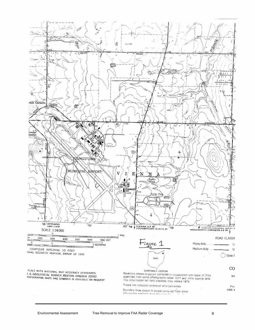
Environmental Assessment Tree Removal to Improve FAA Radar Coverage 9
:' ~- --· ... - ·- - · ·- -- -:.
·· ----"--';---
\
526 ! IGII~ARD! 4866 IINW
SCALE 1:2400J
'JJ/·--~·· 1,-u. .,..
.,_ ~"'"
..,--..
(~ i '1117
· I .... .. ·,~ ... •/
==3:===:=c::=i0e=:;=:;;=:;;:===:==:;==s:==:;==:=:;==:=:;==:;;Sl MILE :>o 2000 3000 sooo ROAD CLASSif
6000 1000 FEET
E.i:5:=E=a:::=E=c=0Es==s==:=:;==s=:;=:;o;::=;~J KILOMET(R
1
CONTOUR INTERVAL lO FEET ONAL GEODETIC VERTICAL DATUM OF 1929
PliES WITH NATIONAL MAP ACCURACY STANDARDS J, S. GEOLOGICAL SURVEY, RESTON, VIRGINIA 22092 TOPOGRAPHIC MAPS AND SYM BOLS IS AVAILABLE ON REQUEST
1=:~re. 1_ Hea;y-duty .... ....... --~- Li
u Medium-duly ... -~--1----..__r.! ' I
j OHIO /
~ ./ / -~..J
QUADRANGLE LOCA11011
Revisions shown m purple com_oiled in cooperation 'Ni!h State of Ohio agencies from aerial pho!ographs !a~en 1977 and o!her source da:a. This in!orma11on not fie!d checked. Map edited 1979
Purp!e ~int ind;cates ex. tension of t.u'Jan areas.
Boundary Hr,es shown in purpte COI'iipiled tiom rat~st infnrr,:~;tinl"\ :u..,tl-.h1 .... ,,. ............ ... .... .... _ , ,. ·•
()state F
co N4
PH AM$ 4
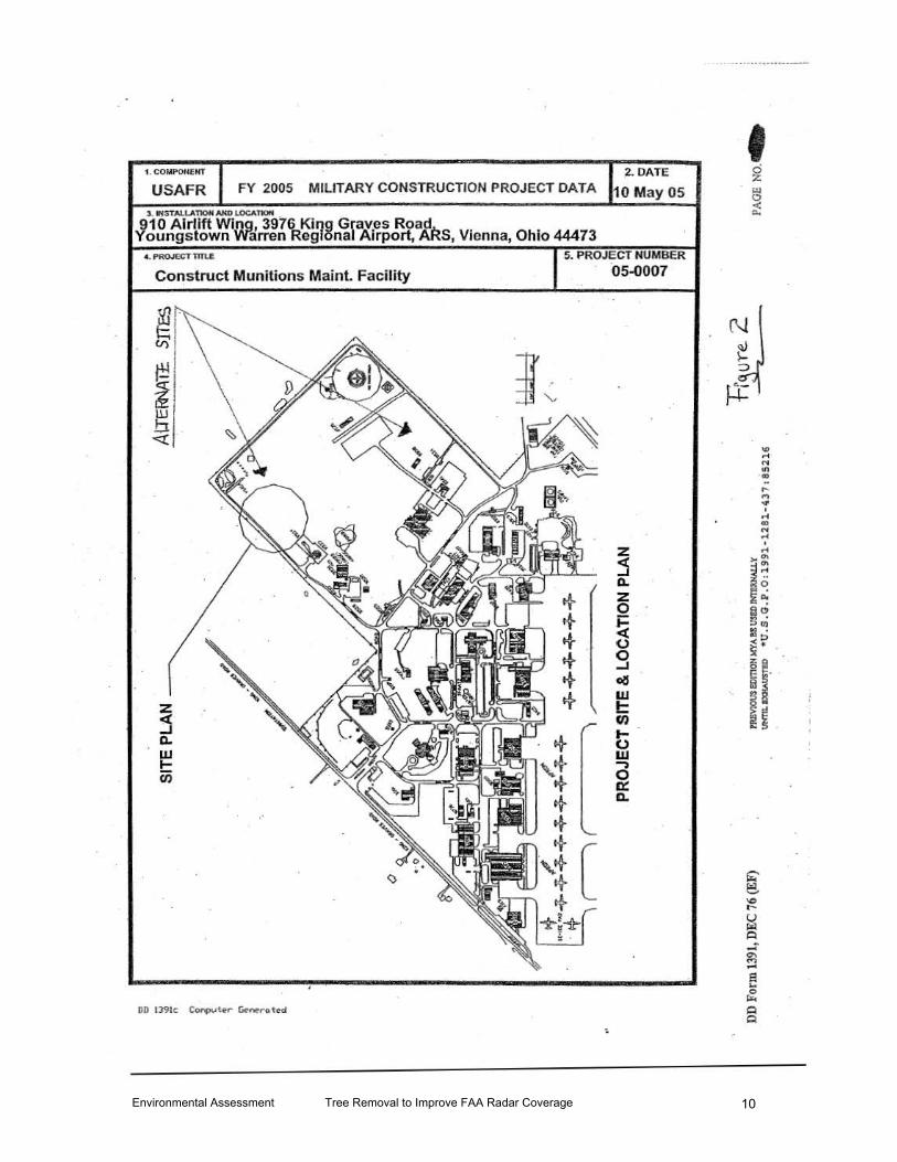
Environmental Assessment Tree Removal to Improve FAA Radar Coverage 10
1. COMI'OHENT
USAFR 2. DATE
FY 2005 MILITARY CONSTRUCTION PROJECT DATA 10 May OS
). IHSTlloU.A'I10fl AND I.OCA,_
910 Alrtlft Wing, 3976 King Graves Road Youngstown Warren Regional Airport, AAS, Vienna, Ohio 44473
Construct Munitions Maint. Facility
5. PROJECT NUMBER
05-0007
z j Q. z 0
!i 0 0 -I ol:l w t:: en ... 0 w -,
~ ll.
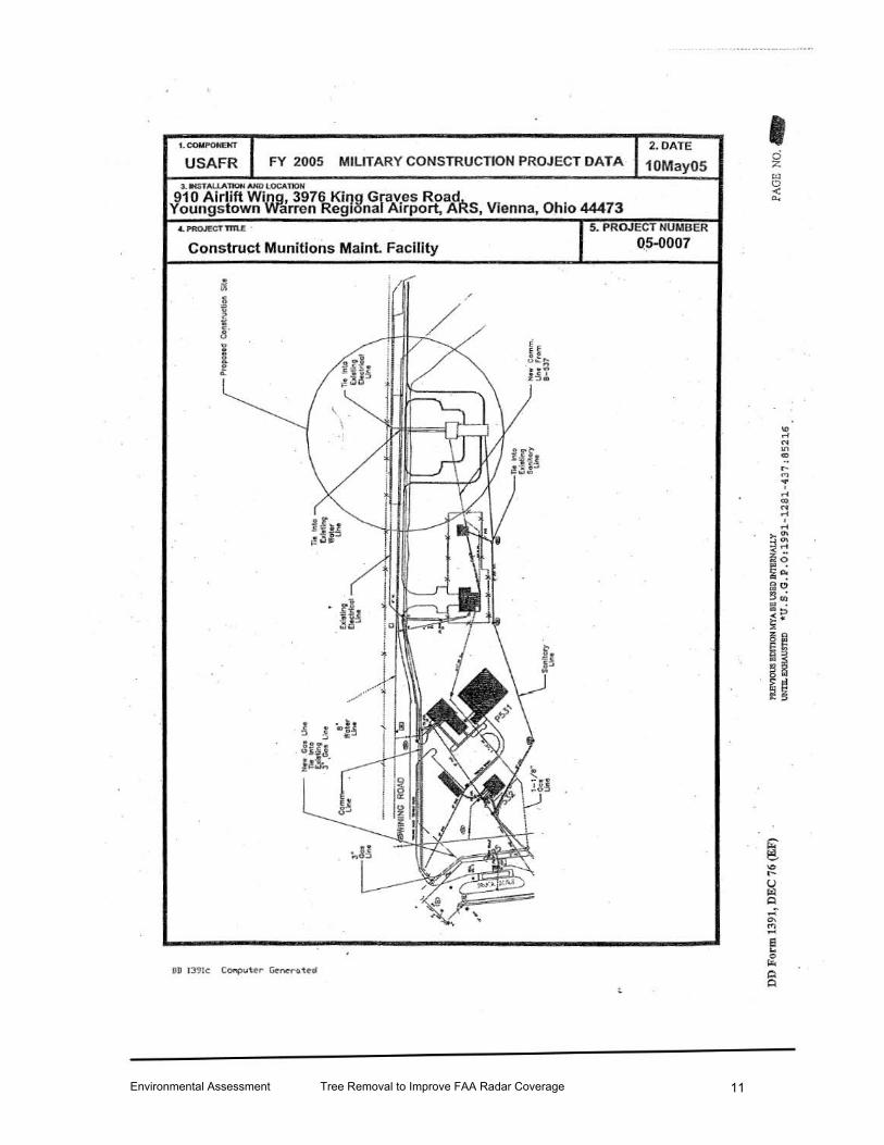
Environmental Assessment Tree Removal to Improve FAA Radar Coverage 11
USAFR FY 2005 MILITARY CONSTRUCTION PROJECT DATA 2.0ATE
10May05 J. _,-AU.ATIOH NfO LOCATIOH
910 A irlift Wing, 3976 Kil)g Graves Road Youngstown Warren Reg1onal Airport, ARS, Vienna, Ohio 44473
Construct Munitions Malnt Facility
5. PROJECT NUMBER
0.5-0007
<
I
[ "" t-u ~ Q ..... "' "' ... e ... 0
"" A A

Environmental Assessment Tree Removal to Improve FAA Radar Coverage 12
11/ 22/ 05 TUB 13 : 47 FAX 6091175 /
910 CIVIL ENG.R
/ .'
United States Department of the Interior
IHitDUWlA TOo
.Mr. Larry o. IA~a&r 910 Airlift Wing/CB
FISH AND WU.DUFESERVICE ~Scmccs
r.9SO·H Amen...., Porlcw:\, R<,..oldaba:z. Ohio 45061
COHM: 614/469- 6923 FAX: 614/469- 6919 August 16, 1995
3976 King Graves Road Younqatown-warran Rql. Aprt. ARS Vienna, Ohio 44473-09.:l0
Dee.r .Mr. Leaaa..r:
Thia reaponde to your r~eet for aasietance in oategorizinq certain lands on the YoUDC]atown Air Rea~e Basa as to their auita.bi.lity for fi.ah and wildlife lllallag~t. Kr. Bill ''Xw:ey of this effie• v.ieitad the ~LrGae in quaation wi th Kr. Greg Wykle of your ata.ff on Auguilt 14 . We have alae raviewG<.l the inatal.lation .clauific:ati.on rulee and would li.lce to S'UI::mit to. you the following obaarY&tione and recommendations.
1. The 36 ilerco of unilllproved louui a.re uiuzuitable tor any but the mo&t · reatrietive hunting and trapping proqra,ms baoauee of tho J.ilzU.tad oiz:e of the parcel. Sa!aty coru~idarations nlight malce. hwrt.inq inadvinbia and t here was no t GnOUSJh habitat for fur bearerii to ~:~alee trapping faaoible.
2. Fishing opportuniti.ee are · &lao l ilnitad, but the pond d.ocaa have IIOCM
recreational fiahi.J:Ig potential. Large Q1ZIIIbera o.f Ul&l.l bluegi..l.la -re observed in the polld. . . 3. The art.im&ted 30 aeres o£. wocxUand .is too aaall an area to inte:rlllrt: liiOUlY or tha neotropi.c&l forest JWstinq birds. Contiguous tr&ct.a of about 200 acraa sGIQal to be tha l.QW end of what these birdll li.lco. Rowe.var, th.iJI iA not to aay that many other spac:i.es o~ llligratory bird.a don't uac the area. The &rCla llli.'1ht ha .. acme potential for bird wa.tchinCJ and natur,e wallca.
4. RBc::oMIGJIDA'l'IOll: From our admittedly l.i.zi.ted Wlde.rsta..nd1.nq of the inrt.alla.tio~ c;.lallification system, ·we rc~nd that the land :parcel in qu•atioo ~e aseiqned to Category II. We su99eat that the area be uaed infozmal.ly "for fishing, bird wa.tchinq, nature wal.lc.8, · and. other a c:ti v iti.GIII th&t arfil c ompatible with .ita :preaent ability to GUpport fiah and wildlife . Category II would· appear to be the proper category buGd on •rgeou.rc:e lLDitationa. •
If yo\l have qu•utiona or we may he of further aoeistance in ~ matter please contact Mr. Bill Xuray of this office at 614-469- 6923.
Sincerely,
Supervisor
c c: : c. SuprGnant, FWS Pi~h. :Res ., Carterville, .IL
la:I002
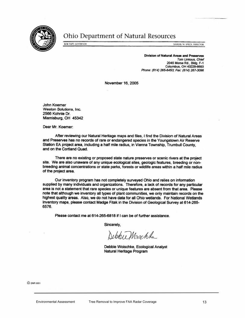
Environmental Assessment Tree Removal to Improve FAA Radar Coverage 13
@ ONIGOOt
Ohio Department of Natural Resources IOIT.uT GO\'£l>SOll
John Koerner Weston Solutions, Inc. 2566 Kohnle Or. Miamisburg, OH 45342
Dear Mr. Koerner:
November 16, 2005
Division of N&ln' Ar.- Md p_._ Tom L.inJrDua, ChifJf
2045 Morn Rd., Bldg. F-1 Columbus, OH 4~
Phone: (814) 28~: Fflx: (6 14) 287.;J096
Att.er reviewing our Natural Heritage maps and files, I find the Division of Natural Areas and Preserves has no records of rare or endangered species in the Youngstown Air Reserve Station EA project area, including a half mile radius, in Vienna Township, Trumbull County, and on the Cortland Quad.
There are no existing or proposed state nature preserves or scenic rivers at the project site. We are also unaware of any unique ecological sites, geologic features, breeding or nonbreeding animal concentrations or state pai'Xs, forests or wildlife areas within a half mile radius of the project area.
Our inventory program has not completely surveyed Ohio and relies on Information supplied by many individuals and organizations. Therefore, a ladt of records for any particular area is not a statement that rare species or unique features are absent from that area. Please note that although we inventory aQ types of plant communities, we only maintain records on the highest quality areas. Also, we do not have data for all Ohio wetland$. For National Wetlands Inventory maps, please contact Madge Fitak in the Division of Geological Survey at 614-265-6576.
Please contact me at 614-265-6818 if I can be of further assistance.
Sincerely,
Debbie Woischke, Ecological Analyst Natural Heritage Program

Environmental Assessment Tree Removal to Improve FAA Radar Coverage 14
Weston Solutions, Inc. 2566 Kohnle Drive Miamisburg, OH 45342 937-384-4200 937-384-4201 (Fax) www.westonsolutions.com
FACSIMILE TRANSMITTAL
To: _O=D:..:NR..:.:..:.-=D:..:i:..:v-=o..:.f.::...N:..::a:.:..t Ar:..=..e::..:a:..::s _ ___ Recipient's Facsimile # 614 -267-3096
-'Ms=-=D=-e::..:b:..:b:.:.ie.::...W..:.;_:o::..:isc=hk<=e _____ Recipient's Telephone # 614-265-6453
From: John Koerner Originator's Telephone# _9=-3=-7'--=-38.::...4.:....-:..:42=-1:..:8:.._ _ ___ _
Total Pages: 4 (Incl. coveT sheet) --'-----
Date: November 14,2005
Comments:
W.O. #: Youngstown EA
Weston Solutions formally requests a search of the Heritage Database for tbc environmeatal features and resonrces checked on the attached request form. This information is being requested to comply "l'l'itb aU of the pertinent coordination and other requirements associated with the USAF Environmental Impact Analysis Process and NEPA . The project site bas been identified on a portion of the Cortl.and, Trumbull County quad that is attached. The project involves construction of a new munitions facility at the Youugstown Air Reserve Station.
Sincerely,
John M. Koerner
WESTON ... Restoring Resource Efficiency
Our services encompass environmental remediation, redevelopment, and management and compliance.
Our emphasis on restoring resource efficiency to our clients' operations-including land, air, water, facilities, and staff-ensures that clients derive maximum value from their resources.
The documents accompanying this tele<:opy transmission contain confidential. privileged or proprietary lnfonnation that either constitutes the property of Weston Solutions. Inc. {WESTON.,.) ot, If the property of another. represoots information lhat Is within WESTON's care, custody and oonlrol. The Information Is ln12nded to be for the use of the indMdual or entity named on the transmission sheet If you are not the intended recipien~ be aware lhat any diSdoSUre. copying or use of the contents of this leteoopied information is prohibited. If you have received this telecopy In error. please notify us by telephone lmnediately so that we can arrange for the retrieval of the original documents at no cost to you. Thank you for your assistance.
WESTON SOLUTIONS, INC. MIAMISBURG. OH
PAGE J.J

Environmental Assessment Tree Removal to Improve FAA Radar Coverage 15
DATA REQUEST
OHIO DEPARTMENT OF NATURAL RESOURCES DIVISION OF NATURAL AREAS AND PRESERVES NATURAL HERITAGE DATA SERVICES 1889 FOUNTAIN SQUARE COURT, BUILDING F-1 COLUMBUS, OHIO 43224 PHONE: 614-265-6453; FAX: 614-267-3096
INSTRUCTIONS: . Fill out both pages of the form; sign it and return it to the address or fax number listed above along with: (1) a letter formally requesting data and describing your project, and (2) a map detailing the boundaries of your study area. A photocopy from the pertinent portion of a USGS 7.5 minute topographic map is preferred t>ut other maps are acceptable. Our turnaround ti me is two weeks, although we can often respond more quickly.
~ Fees are determined by the amount of time it takes to complete your project. The charge is $25.00 per Y. hour with a Y. hour minimum. We can perform a data search manually or by computer. The Heritage Data Services staff will determine the most cost-efficient method of doi111g your search. A cost estimate can be provided upon request. Unless otherwise specified, an invoice will accompany the data services response.
:l&" ..... 'l" ..... "*********** ** *****'Ill t * ................... ' .............................. ** * ........... ** ....... * ................ ""***
This request is being submitted by: )(tax o mail o both
Date: /4 ;\LNi.mbv 2{)()~5" ~ Your Agency/Organization: W~te ~fu · '01s _::;;[~u Your Name!Tifie: -=r o h n AI Ko~eY; S" ~NJd; S: 4e-!At'sf Address: Z~ t;;.bak bdve
1
City/State/Zip: i>4itl:, bJ~ 4534 t Phone/Fax: 9s 1- 3~4- 4 218' .fa:t: q3 7- -'i58'!}_- 1:2 D1. Project Name/Number: Jonnq~J~~wo Atr Kes0erve S'+dl~~ EA Project is located on the following USGS 7.5 minute topographic map(s): _ ______ _
Ct>Jlo Mcl 1 C2lt If there is a program·or contracting agency requiring this information, please give the name and phone number of a contact person:

Environmental Assessment Tree Removal to Improve FAA Radar Coverage 16
The Natural Heritage Data Base contains records for the categories of species and features listed below. Check the appropriate boxes to indicate your selection.
. PLANTS: o Federal Status Only ANIMALS: o Federal Status Only o State Legal Status Only o Rare (non-legal status) X All of the above
o State Legal Status Only o Rare (non-legal status) X All of the above
PLANT COMMUNITIES: }(All o Wetlands Only o Other ________________ . ______________________ _
OTHER FEATURES: o Geologic Features o Breeding/Non-breeding Animal Concentrations o Champion Trees o State Nature Preserves and Natural Areas o State Wild, Scenic and Recreational Rivers ~State Pa~s. Forests, Wildlife Areas .I'{ All of the above
o Other .
Besides name, location and status, specify any additional information you need:
None
The area you want searched: o study area as ouUined on the map )(Study area plus Yz mile radius o study area plus 1 mile radius oother ___________________________________ __
The information supplied above is complete and accurate. Any material supplied by the Natural Heritage Data Base will not be published without prior written permission and without crediting the
DM•Ioo of Nalucol A<ea. "'' P...eNe' '" e ' ~- at al
ONR 52C3 Rev. 9197
YourSignature~~~~1_~tl~·~~~~~==~===::::::__

Environmental Assessment Tree Removal to Improve FAA Radar Coverage 17
~ ·-- - -----' ----·- .
r- ,, ... ...j .·,. j -·-"·...._ '\ ~ I
./I =-L --, \"' \ r--T- :- - ---:- --f : I ~/ I I l A ! ' ·a i '<11 77
.· .....
SCALE 1:24000
~&iiii1iiiii:;=:Jl•:;;*5959:=:i0i!ii!<55ESE;;a;--lliii:!lll:!ii5o::=55;=::;;:=:;;ll Mil£ lO 2000 3000 -1000 !iOOO 6000 7000 f(Er 5 • 1
sc~5 =a~:e~~0~s=~es~E$&E~ED1~
CONTOUR INTERVAL :0 FEET OtiAL GEODETIC VERTICAL OATVH OF 1929
Plf(S WI Tii NATIONAl MA• ACCURACY STANOAROS
l . S GCOLOGfCAL SURVEY. R£STON, VIRGINIA 22092 fOI'OcRAPIIIC MAPS AHO SYMilOlS IS AVAilASL( ON REQUEST
Hcavy~uly
Medtumduly
~lCICATOI Rev'.sioos s~ m l)l.lt~ eomp.lao In cooPer a loon w•th Slate of 01>10 agencies from aer~a: I)IIOrOQtallh$ ta!<e:> 1977 and Other soorce data ThiS inlorma110~ '101 loeld cllec~ed l<ao ed•led 1979
Purple unt rnd•ca es tx1ensl()n or urban areas
Bnunoary lines sl'own In purple compiled !rom latest
ROAD CLASSII
L
u () State I
cc II<
PH AMS•
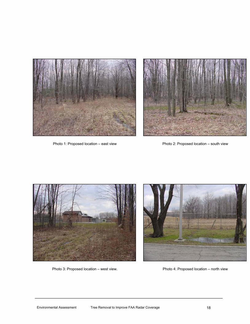
Environmental Assessment Tree Removal to Improve FAA Radar Coverage 18
Photo 1: Proposed location – east view Photo 2: Proposed location – south view
Photo 3: Proposed location – west view. Photo 4: Proposed location – north view

Environmental Assessment Tree Removal to Improve FAA Radar Coverage 19
Photo 5: Alternate “A” location – east view Photo 6: Alternate “A” location – south view
Photo 7: Alternate “A” location – west view. Photo 8: Alternate “A” location – north view

Environmental Assessment Tree Removal to Improve FAA Radar Coverage 20
Photo 9: Alternate “B” location – east view Photo 10: Alternate “B” location – south view
Photo 11: Alternate “B” location – west view. Photo 12: Alternate “B” location – north view