Embed Size (px)
Citation preview
A1
G1
G2
B
F
A3
B
A5
B
B
C
B
A6
A6
F
A3
F
F
A6
P
G2
F
B
A3
C
C
B
A3
B
P
B
B
F
A6
C
F
A6
A6
A2
A1
A2
E2
A6
A6
E1
A2
F
P
E2
B
A6
A3
B
G1
E2
C
B
E1
B
E1
P
F
C
C
A6
F
P
A2
F
A3
E2
A2
G1
A3
F
P
A6
E2
A2
L1
F
A2
P
A3
A3
B
F
A6
F
P
B
A2
B
C
A2
E1
A6
P
C
E1
P
E1
E1
E2
F
A2
A3
P
E1
E1
A2
E1
A2
B
A2
G2
B
E1
E1
A6
B
A3
E1
A3
P
E1
E1
E1
A2
A2
E1
A4
A2
G1
P
A3
E2
A2
A2
E1
A2
F
E1
E1
A3
A3
E1
B
A2
E1
A2
G1
P
A2
A2
A6
A2
A2
E1
E1
P A2
A2
A2
A3
C
C
E1
P
B
A2
P
E1
PP
P
G1F
P
P
E1
A2
A2
L2
E1
P
PE1
P
A3
A2
A3
A4
E1
A3
A2
P
P
A3
P
A6
P
A6
A2
P
A3
A2
A2
P
B
A2
A6
F
P
A3A2
B
P
A2
P
P
P
P
A2
A2
C
P
A2
A2
P
A3
A2
B
P
P
A2
A4
G1
P
A6
P
P
A2
P
P
A6
A3
P
A2
A3
P
P
P
A4
P
A6
C
A6
C
P
A2
P
P
A2
A2
G1
A2
A2
P
A2
A2
G1
A2
A2
A2
P
A2
E1
B
P
B
C
A2G2
G1
A1
A1A2
G1
P
G1
F
A1
A1
A1
144° 00’63° 30’
63° 35’
63°40’
144° 50’ 144° 40’
144° 00’
144° 40’
144° 50’
63°40’
63° 35’
63° 30’
State of AlaskaDepartment of Natural Resources
Division of Geological & Geophysical Surveys
ALASKA
SI CAL
SU
R
ND GEOPHY
VE
YS
AL A
GE
OL
OG
IC
ALASKA DIVISION OF GEOLOGICAL &GEOPHYSICAL SURVEYS
PRELIMINARY INTERPRETIVE REPORT 2009-6b Hubbard and Reger (2010) SHEET 1 of 4
ENGINEERING-GEOLOGIC MAP, ALASKA HIGHWAY CORRIDOR, PART OF THE TANACROSS C-6 QUADRANGLE, ALASKA
Affiliations¹ Alaska Division of Geological & Geophysical Surveys² Reger’s Geologic Consulting, Soldotna, Alaska
byT.D. Hubbard¹ and R.D. Reger², 2010
CONTOUR INTERVAL 100 FEETDATUM IS MEAN SEA LEVEL
SCALE 1:63,360 22
TRU
EN
OR
TH
MAG
NETI
CNO
RTH
APPROXIMATE MEANDECLINATION, 2010
ALASKA
Tanacross Quadrangle
Maps Showing Location of Study Area
Topographic base map from:Tanacross C-6 quadrangle,U.S. Geological Survey, 1954. U.S. Geological Survey digital raster graphic images, 1997.Map projection: UTM zone 7Datum: NAD 27
Tayl
or
Hig
hw
ay
Alaska Highway
PHOTOINTERPRETIVE BOUNDARY—All boundaries are inferred or approximately located
LAKE
MAP SYMBOLS
INTRODUCTION
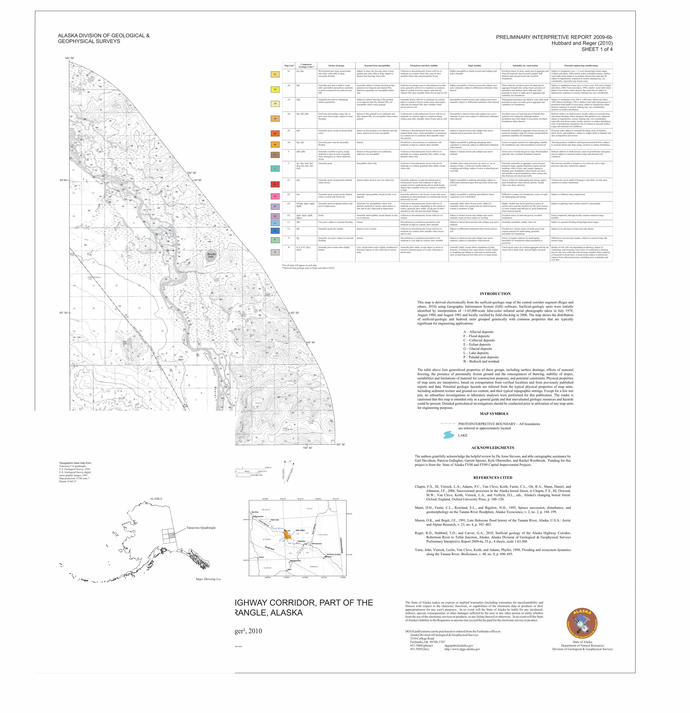
This map is derived electronically from the surficial-geologic map of the central corridor segment (Reger and others, 2010) using Geographic Information System (GIS) software. Surficial-geologic units were initially identified by interpretation of ~1:65,000-scale false-color infrared aerial photographs taken in July 1978, August 1980, and August 1981 and locally verified by field checking in 2008. The map shows the distribution of surficial-geologic and bedrock units grouped genetically with common properties that are typically significant for engineering applications:
A – Alluvial deposits F – Flood deposits C – Colluvial deposits E – Eolian deposits G – Glacial deposits L – Lake deposits P – Paludal peat deposits B – Bedrock and residual
The table above lists generalized properties of these groups, including surface drainage, effects of seasonal freezing, the presence of perennially frozen ground and the consequences of thawing, stability of slopes, suitabilities and limitations of material for construction purposes, and potential constraints. Physical properties of map units are interpretive, based on extrapolation from verified localities and from previously published reports and data. Potential geologic hazards are inferred from the typical physical properties of map units, including sediment texture and ground-ice content, and their typical topographic settings. Except for a few test pits, no subsurface investigations or laboratory analyses were performed for this publication. The reader is cautioned that this map is intended only as a general guide and that unevaluated geologic resources and hazards could be present. Detailed geotechnical investigations should be conducted prior to utilization of any map units for engineering purposes.
ACKNOWLEDGMENTS
The authors gratefully acknowledge the helpful review by De Anne Stevens, and able cartographic assistance by Gail Davidson, Patricia Gallagher, Garrett Speeter, Kyle Obermiller, and Rachel Westbrook. Funding for this project is from the State of Alaska FY08 and FY09 Capital Improvement Projects.
REFERENCES CITED
Chapin, F.S., III, Viereck, L.A., Adams, P.C., Van Cleve, Keith, Fastie, C.L., Ott, R.A., Mann, Daniel, and Johnston, J.F., 2006, Successional processes in the Alaska boreal forest, in Chapin, F.S., III, Oswood, M.W., Van Cleve, Keith, Viereck, L.A., and Verbyla, D.L., eds., Alaska's changing boreal forest: Oxford, England, Oxford University Press, p. 100–120.
Mann, D.H., Fastie, C.L., Rowland, E.L., and Bigelow, N.H., 1995, Spruce succession, disturbance, and geomorphology on the Tanana River floodplain, Alaska: Ecoscience, v. 2, no. 2, p. 184–199.
Mason, O.K., and Begét, J.E., 1991, Late Holocene flood history of the Tanana River, Alaska, U.S.A.: Arctic and Alpine Research, v. 23, no. 4, p. 392–403.
Reger, R.D., Hubbard, T.D., and Carver, G.A., 2010, Surficial geology of the Alaska Highway Corridor, Robertson River to Tetlin Junction, Alaska: Alaska Division of Geological & Geophysical Surveys Preliminary Interpretive Report 2009-6a, 55 p., 4 sheets, scale 1:63,360.
Yarie, John, Viereck, Leslie, Van Cleve, Keith, and Adams, Phyllis, 1998, Flooding and ecosystem dynamics along the Tanana River: BioScience, v. 48, no. 9, p. 690–695.
The State of Alaska makes no express or implied warranties (including warranties for merchantability andfitness) with respect to the character, functions, or capabilities of the electronic data or products or theirappropriateness for any user's purposes. In no event will the State of Alaska be liable for any incidental,indirect, special, consequential, or other damages suffered by the user or any other person or entity whetherfrom the use of the electronic services or products, or any failure thereof or otherwise. In no event will the StateofAlaska's liability to the Requestor or anyone else exceed the fee paid for the electronic service or product.
DGGS publications can be purchased or ordered from the Fairbanks office at:Alaska Division of Geological & Geophysical Surveys3354 College RoadFairbanks,AK 99709-3707451-5000 (phone) [email protected] (fax) http://www.dggs.alaska.gov
*Not all units will appear on each map**Derived from geologic units in Reger and others (2010).
Map Unit*
8
Component Geologic Units** Surface drainage Seasonal frost susceptibility Permafrost and thaw stability Slope stability Suitability for construction Potential engineering considerations
A1 Qa, Qaa Well drained near steep stream banks and where water table is deep; seasonally flooded
Subject to deep, dry freezing where coarse grained and water table is deep; subject to intense frost heaving where silty
Unfrozen to discontinuously frozen with low to moderate ice content where silty; may be thaw unstable where silty and perennially frozen
Highly susceptible to lateral erosion and collapse near active channels
Excellent source of clean, sandy gravel aggregate and clean fill material; may be poorly graded; well-drained sand and gravel provide excellent foundations
Subject to inundation every 1–5 years during high stream stages (Chapin and others, 2006) and by aufeis in braided reaches; shallow water table limits depth of excavation; thawed fine sand and silt subject to liquefaction; responses to seismic shaking may vary considerably, especially near frozen zones
A2 Qai Generally poor due to shallow water table and shallow permafrost; moderate to good on natural levees and crevasse fills
Generally subject to intense heaving in fine-grained cover deposits and channel fills; otherwise, generally not susceptible unless silty
Unfrozen in younger areas to discontinuous in older areas, generally with low to moderate ice contents; high ice content in frozen organic sand and silt channel fills; thaw unstable where frozen and ice rich
Highly susceptible to lateral erosion and collapse near active channels; subject to differential settlement when thawed
Where thawed, excellent source of sandy gravel aggregate beneath silty surface layer; presence of permafrost and shallow water table may limit potential as source of sandy gravel aggregate and suitability for foundations
Subject to inundation at least once or twice every 100 years (Chapin and others, 2006; Yarie and others, 1998); shallow water table limits depth of excavation; where thawed, fine sand and silt subject to liquefaction; responses to seismic shaking may vary considerably.
A3 Qab Generally poor due to widespread shallow permafrost
Subject to intense heaving in fine-grained cover deposits and silty channel fills; not susceptible where coarse grained
Generally frozen with low to moderate ice content; high ice content in frozen surface peats and organic sand and silt channel fills; thaw unstable where frozen and ice rich
Susceptible to lateral erosion and collapse near active channels; subject to differential settlement when thawed
Widespread permafrost and shallow water table limit potential as source of sandy gravel aggregate and suitability for foundations
Subject to inundation every 500 to 1,000 years (Mann and others, 1995; Mason and Begét, 1991); shallow water table and presence of permafrost limit depth of excavation; subject to liquefaction where thawed; responses to seismic shaking may vary considerably; sensitive to surface disturbance
A4 Qat, Qft, Qfte Good near descending scarps; fair to poor away from scarps; subject to local flooding
Intense in fine-grained cover sediments and silty channel fills; not susceptible where coarse grained
Continuously to discontinuously frozen with low to moderate ice content; high ice content in frozen surface peat; thaw unstable where frozen and ice rich
Susceptible to lateral erosion and collapse near active channels; frozen zones subject to differential settlement when thawed
Excellent source of sand and gravel beneath fine-grained cover sediments, although shallow permafrost may limit depth of excavation; excellent foundations where thawed
Bedrock shallow in strath terraces; locally subject to seasonal slope and stream flooding; where saturated, fine-grained cover sediments subject to liquefaction; seismic shaking may vary considerably, especially near frozen zones; locally sensitive to surface disturbance; areas of groundwater emergence may be subject to seasonal surface icings and saturated soil conditions
A5 Qaf Generally good, except in frozen distal zones
Intense in fine-grained cover deposits and silty zones, otherwise not frost susceptible
Unfrozen to discontinuously frozen, except in fine-grained distal zones, where permafrost is continuous; ice contents low to moderate; thaw unstable where fine grained
Subject to lateral erosion and collapse near active channels and in proximal zone of fan
Generally unsuitable as aggregate source because of numerous boulders, high silt content, and permafrost; moderate suitability for foundations
Proximal zones subject to torrential flooding, snow avalanches, debris flows, and mudflows; subject to sudden shifts in channels and sites of deposition and erosion
A6 Qer, Qfs Generally poor; may be seasonally flooded
Intense Permafrost is discontinuous to continuous with moderate to high ice content; thaw unstable
Highly susceptible to gullying and piping when vegetation is removed; subject to differential settlement when thawed
Source of organic material for landscaping; suitable for foundations only when permafrost is preserved
Thawing produces mudflows and hyperconcentrated flows; subject to seasonal stream and slope icings; sensitive to surface disturbance
F Qfb, Qfbe Generally excellent to good, except moderate to poor in areas of ground water emergence or where shallowly frozen
Intense in fine-grained cover sediments; otherwise, not susceptible
Unfrozen to discontinuously frozen with low to moderate ice content; generally thaw stable, except unstable where silty
Subject to lateral erosion and collapse near active channels
Good source of sand and gravel; large flood boulders generally rare; excellent foundation material
Bedrock shallow in strath terraces; areas of groundwater emergence may be subject to seasonal surface icings and saturated soil conditions
C Qc, Qca, Qcd, Qcf, Qcg, Qcl, Qcr, Qct, Qcft,
Generally good Susceptible where silty Unfrozen to discontinuously frozen with low to moderate ice content; generally thaw stable, except where silty
Unstable where slope processes are active or toe or margin of slope is removed; locally subject to sloughing and sliding; subject to snow avalanching and rock falls
Generally unsuitable as aggregate source because numerous large, angular fragments require special handling; where frozen, may require ripping or blasting; poor foundations where blocks are loose and unstable to good foundations where coarse and fine fractions are mixed and stable
May become unstable if margins or toe removed; active slope processes may have deleterious impacts
E1 Qel Generally good, except poorly drained where frozen
Intense where moist to wet; low where dry Generally unfrozen, except discontinuously to continuously frozen with moderate to high ice content on lower south-facing and on north-facing slopes; thaw unstable where ice content is moderate to high
Highly susceptible to gullying and piping; subject to differential settlement upon thawing where frozen and ice-rich
Source of fines for landscaping and mixing; makes good foundations where thawed and dry; muddy when wet; dusty when dry
Vertical cuts can be stable if drainage is provided; ice-rich areas sensitive to surface disturbance
E2 Qes Generally good, except poorly drained where covered with frozen silt
Generally unsusceptible, except in silty cover deposits
Generally unfrozen to dry frozen, except silty cover sediments are discontinuously to continuously frozen and locally ice rich
Highly susceptible to gullying and deflation where vegetation cover is disturbed
Difficult to compact for foundations; source of sand for landscaping and mixing
Subject to deflation where unprotected
G1 QTgdp, Qgdo, Qgdy, Qgdh
Generally good on upland surfaces and poor in depressions
Generally low susceptibility where well drained, moderate to intense where matrix is silty and in silty slopewash in depressions
Unfrozen to discontinuously frozen with low to moderate ice contents, depending on silt content of matrix; generally thaw stable, except may be thaw unstable in silty tills and silty kettle fillings
Generally stable where frozen or dry; subject to instability where fine-grained tills are thawed and ice content is moderate to high
Highly variable but can be good local source of mixed coarse and fine fractions for fill; local sources of water-washed sand and gravel; good foundations where thawed and dry
Subject to gullying where surface runoff is concentrated
G2 Qgfo, Qgfy, Qgfh, Qgfyy
Good Generally unsusceptible, except intense in silty cover deposits
Unfrozen to discontinuously frozen with low ice content
Subject to lateral erosion and collapse near active channels, steep cut faces subject to raveling
Excellent source of sand and gravel; excellent foundations
Easily compacted, although locally contains numerous large boulders
L1 Qlb Very poor; subject to seasonal flooding Intense Discontinuous to continuous permafrost with moderate to high ice content; thaw unstable
Subject to lateral thermoerosion and collapse near active channels
Generally unsuitable; muddy when wet Subject to seasonal flooding during high stream stages
L2 Qlr Generally good, but variable Intense if wet or moist Unfrozen to discontinuously frozen with low to moderate ice content; thaw unstable where frozen and ice rich
Subject to differential settlement where frozen and ice rich
Possible low-volume source of sandy gravel and organic material for landscaping; generally unsuitable for foundations
Subject to ice shoving in winter near lake shores
P Qp Generally very poor; subject to seasonal flooding
Intense Discontinuous to continuous permafrost with moderate to very high ice content; thaw unstable
Subject to lateral erosion and collapse near active channels; subject to subsidence when thawed
Source of organic material for landscaping; unsuitable for foundations unless permafrost is preserved
Difficult to excavate and compact; subject to seasonal slope and stream icings
B b, b', b+b', (Qc), (Qcf)
Generally poor except where highly broken
Low, except where rock is highly weathered or fractured; intense in silty colluvium in mixed units
Generally thaw stable, except where ice forms in extensive fracture spaces or in silty colluvium in mixed units
Generally stable, except where orientation of joints, fractures, or foliation may cause failure; locally subject to sloughing and sliding in colluvium on mixed units; snow avalanching and rock falls active in steep terrain
Can be good source for crushed aggregate and rip rap where rock is hard, fresh, and not highly fractured
Quality of rock will vary depending on lithology, degree of weathering, and fracturing; local zones of weathering or shearing may be clay rich; colluvium only becomes unstable where undercut or fractured in mixed units; in steep terrain subject to deleterious impacts from colluvial processes, including snow avalanches and rock falls
A6
B
A3
P
A4
F
E1
A1
C
L2
L1
G2
G1
E2
A2
A5