Embed Size (px)
Citation preview

ENERGY LOOP SCENIC BYWAY CORRIDOR MANAGEMENT PLAN UPDATE
2011
Energy Loop Scenic Byway Steering Committee:
Jana Abrams, Energy Loop Scenic Byway Coordinator
Bill Broadbear, US Forest Service
Rosann Fillmore, US Forest Service
Chanel Atwood, Castle Country Regional Information Center
Tina Carter, Emery County Travel Bureau
Kathy Hanna Smith, Carbon County Travel Bureau
Kevin Christensen, Sanpete County Economic Development
Mike McCandless, Emery County Economic Development
Dan Richards, Utah State Parks Division
Floyd Powell, Utah State Parks Division
Nicole Nielson, Utah Division of Wildlife Resources
Dale Stapley, Utah Department of Transportation
Kevin Nichol, Utah Department of Transportation
Gael Duffy Hill, Utah Office ofTourism
PREPARED BY
Fehr& Peers
2180 South 1300 East Suite 220
Salt Lake City_ Utah 84106
p 801.463.7600
Bonneville Research
170 South Main Street, Suite 775
Salt Lake City_ Utah 84101
p 801.364.5300

"--'
CONTENTS ""'-'
'-.~·
""-'
1: Executive Summary 1 Commercial Truck Traffic 35 ""'-"
6: Highway Safety and Management 35 ~
2: Introduction 5 "--"
Byway Corridor Description 5 Commuter Traffic 36 ""-"
Purpose of Corridor Management Plan 6 Tourism Traffic 36 ~
'<../
Guiding Purpose 9 Highway Safety Management Strategies 41 '-"
Mission and Vision Statement 9 7: Interpretation 45 '-.../
"'-'
3: Byway Organizational Plan 9 Demographic Summary 49 ""-"
Goals 10 Energy Loop Key Travel/Tourism Information 49 ~
Location and Access 49 """ Byway Committee 11 "'-"
Byway Coordinator 12 8: Demographics and Economic Development 49 "'-/
Public Participation 12 "'-" Promotion of Loop Tours 53
""'-' Assessment and Significance 15 Audience Potential 53 ~
4: Resource and Intrinsic Quality 15 Changes Since 1999 55
""' Recreation Resources 16 9: Byway Improvements and Implementation 55 "'-"
Geologic, Paleontologic, and Hydrologic Resources 18 Proposed Projects for Implementation ""' 56 "'--'
Vegetative Resources 20 Recent Developments in Scenic Byway Legislation 63 ......,
Wildlife and Fish Resources 21 "'--' 10: Multilingual Accommodations 69
Visual Resources 22 ""-".
Cultural and Historic Resources 11: Monitoring and Evaluation 70 ""' 23 ""--'
Industrial Resources 24 Monitoring and Evaluation 70 '--./
Agreements 31 Impact Assessment 70 "'-"
""-"' Land Status 31 Annual Byway Status 70
'--./
Governing Regulations 31 Regular Meetings 70 """'
Natural Resources Organizational Review 71 ""-" 5: Resource Management and Protection 31
"""-"'
Cultural and Historic Resources 32 12: References 73 "'-'
""--'
"--''

c
,--\
c
FIGURES Figure 1: Corridor Boundary Map with Intrinsic Qualities and Land Uses 7
Figure 2: Recreational Resources
Figure 3: Natural Resources
Figure 4: Mining Resources
Figure 5: Existing ADT and Truck Traffic
Figure 6: Existing Interpretive Sites
Figure 7: Potential Project Sites
TABLES Table ES-1: Summary of Potential Projects and Strategies
Table 4-1: Facilities by Location
Table 4-2: Trails
Table 6-1: UDOT Highway Safety Statistics from 2005-2007
Table 7-1: Interpretive Sites
Table 8-1: Demographic Summary
Table 8-2: Energy Loop Visitor Facilities
Table 8-3: Energy Loop Tourism Spending
Table 9-1: Summary of Potential Projects and Strategies
APPENDICES Utah County Letter of No Interest
Resolution of Support from Byway Communities
Summary of Public Involvement Activities
26
27
28
37
47
66
2
17
19
39
46
50
51
52
64


1: EXECUTIVE SUMMARY The goal of the Energy Loop Scenic Byway Corridor Management Plan Update is to outline a broadly acceptable plan for the careful use and management of the resources that make up the Energy Loop Scenic Byway.
Strategies within this plan identify important management issues that are necessary to maintain its scenic, natural, historic, and recreational values for future generations to enjoy. Each community near the Byway has a role to play in this effort. Most importantly, we recognize that the Byway is a special place, a place many think of as their own backyard. This plan is to ensure that it stays this way.
The plan further outlines economic opportunities that combine the drawing power of the Energy Loop Scenic Byway with the rich and distinctive resources found within the communities and surrounding resources of the four county region. Through a collaborative planning effort, the counties of Carbon, Emery, Sanpete, and Utah have an opportunity to prepare their gateway communities and the cultural and natural resources surrounding the Byway into a comprehensive, coordinated tourism package for visitors to enjoy and appreciate.
Each community will determine its own approach to tourism development but will communicate and combine efforts as part of a larger package with the other areas, using the Energy Loop Scenic Byway as the transportation corridor that connects them. Development principles such as conservation, preservation, cultural sensitivity and responsible use of resources will guide this effort.
This four-county strategy will provide a positive outcome for both the economy of gateway communities and the resources of the Byway and surrounding area. First, gateway communities will continue to benefit from
the projected economic impacts of invited guests purchasing amenities
such as lodging, food, fuel, gifts and specialized services. Second, through cooperative planning and marketing of resources and services, the region will provide for a diversity and density of experiences that will keep visitors in the region longer and encourage return visitation. Third, the gateway communities will help disperse use across the region, simultaneously
spreading the potential negative impacts of overuse while
spreading the positive impacts of economic development across the larger area. Together, this balance of protection and promotion must be maintained along the Energy Loop and carried into the surrounding gateway communities and natural areas.
The previous Corridor Management Plan has been updated to help implement the resource management goals, safety and interpretive strategies, and economic initiatives
created by the Energy Loop Scenic Byway Committee and participating organizations and individuals. This plan provides an update to the status of land and natural resources, existing and proposed interpretive features, economic and demographic characteristics of the area, and legislative concerns for scenic byways in Utah.
Anumberofmarketing, tourism and business development strategies are set forth in this document to complement the current economic conditions of Carbon, Emery, Sanpete, and Utah Counties. Where appropriate, recommendations are made for infrastructure improvements.
The 1999 Corridor Management Plan identified many new interpretive kiosks that enhance visitor experience to the Energy Loop. This Corridor Management Plan update builds on those efforts, and identifies new interpretive and management ideas for implementation along the Energy
Loop. Additional suggestions for interpretation and marketing of the distinctive resources of the four county region are described in the plan. This update also includes a section on highway safety and management,
information on recent changes to Scenic Byway legislation in Utah, and incorporates recommendations on integrating various Byway partners into future planning efforts. The following table provides a summary of the recommendations included in this Corridor Management Plan. Proposed project locations are identified in Figure 7.

TABLE ES-1: SUMMARY OF POTENTIAL PROJECTS AND STRATEGIES
16 Install parking diagrams at the Big Drift
ENERGY LOOP CORRIDOR MANAGEMENT PLAN
Manti-La Sal National Forest,
Energy Loop Scenic Byway Coordinator
,-·--,
0 0

c c ENERGY LOOP CORRIDOR MANAGEMENT PLAN 3


l: INTRODUCTION The Energy Loop Scenic Byway provides a unique and distinctive linkage between the historic, geological, and cultural makeup of central Utah. The Energy Loop encapsulates the marriage between the Byway's abundant
natural resources and the mining and power plants located adjacent to the roadways. However, there are many other distinctive themes to explore when visitors get out of their vehicles.
The Byway provides a scenic connection between the east and westside settlements of the Wasatch Plateau. On the eastern side of the plateau, Byway travelers will drop down into communities that were settled as part of the Mormon expansion decree, moving across the Wasatch Plateau eastward from Sanpete County. These communities started as early farming and ranching settlements, but became closely linked to coal mining, railroad transportation, and oil and gas production. Easily representing the largest melting pot in Utah's early history, people from over 30 countries, including Greece, Italy, Mexico, Poland, China, Denmark, Britain, and Finland, came to this area to harvest the natural resources found along the Byway. Travelers can learn more about their stories by visiting local museums, attending ongoing festivals and exploring the historic downtowns and communities.
In contrast, the western gateway communities found along the Sanpete Valley will transport visitors back to a time when the area was inhabited by Ute/Paiute Indians and later settled by Mormon families who depended more on an agrarian-based economy. There still exists evidence of prehistoric Native American cultures in the historic and archaeological sites discovered in nearby canyons on both sides of the plateau. Where the eastern side of the Byway celebrates its pioneering history and mining legacy, the western side has preserved its early architectural treasures and celebrates its culture with special events, talented artists and crafters, and
community museums.
All the gateway communities along the Energy Loop Scenic Byway have
indicated their support for this Corridor Management Plan update. Resolutions of support can be found in the Appendices of this document.
BYWAY CORRIDOR DESCRIPTION Working its way across the Wasatch Plateau, just west of the San Rafael Swell and east of the Sanpete Valley, travelers will find 101 miles of breathtaking roadway that make up the Energy Loop. The Byway traverses portions of the Manti-La Sal National Forest and provides visitors with a tremendous diversity of scenic, geologic, historic, cultural and recreational resources found few places in the United States. The winding drive passes by reservoirs, lakes, and streams that not only provide tremendous recreational venues, but supply water to the valleys for residential, industrial and agrarian use.
These canyons sustain a wide diversity of habitat types and wildlife species. Wildlife viewing is a popular pastime, with big game including moose, elk, and mule deer visible along the Byway, particularly in early morning, evening, and during migration periods of each year. Black bear, mountain lion, blue grouse, and a wide variety of raptors including golden and bald eagles all make the Byway their habitat. Hunting and fishing are also important management tools and economic development strategies for local communities near the Byway, bringing in thousands of recreationists to the area each year.
The hundreds of individual plant species which grow along the Byway are characteristic of the mountains of the Colorado Plateau and eastern Great Basin. Aspen, spruce-fir, mountain brush, pinion-juniper and sagebrush
provide a pleasant viewshed along the Byway, while several streams introduce riparian zones of cottonwoods, willows and a variety of wetland sedges and grasses for contrast. Traveling up the Byway from the valleys
below provides visitors with an opportunity to experience several bioregions, ranging from desert to high mountain plateau. With the diversity
of vegetation and natural resources, the scenery offers the traveler everchanging panoramic views.

The Energy Loop Scenic Byway connects the towns of Fairview on the west side of the plateau and Huntington, Scofield, and Helper on the east, reaching an elevation of over 10,000 feet at its summit. Passing by high elevation lakes, reservoirs and streams, the Byway sweeps past a coal-fired energy generating plant. Portions of the famous "Skyline Drive" link Eccles Canyon with Huntington Canyon, as this 16 mile stretch provides "top of the world" views of distant mountain ranges and valleys. The Byway also passes by working coal mines and historic mining towns, through the town of Scofield and past its eponymous reservoir, as the Byway extends toward Price Canyon.
This Corridor Management Plan Update proposes two extensions to the Energy Loop: Price Canyon and SR-10. Price Canyon extends along US-6 down the canyon, linking the Energy Loop Scenic Byway to the south boundaries of the town of Helper, named after the "helper" trains. This extension showcases the coal veins, which can be easily seen along US-6 in Price Canyon and are nationally known as an important opportunity to view natural resources up close. The Huntington Canyon and Eccles Canyon sections of the Energy Loop have been designated National Forest and State Scenic Byways since 1992. The Price Canyon section must be established as a State Scenic Byway before it can become part of the Energy Loop Scenic Byway. The section of SR-10 from SR-31 in Huntington to Huntington State Park is also proposed as an extension to the Energy Loop Scenic Byway, and will need to be designated as a State Scenic Byway first. This extension provides a more intuitive ending point to the Byway in Huntington State Park, a popular recreation area.
PURPOSE OF CORRIDOR MANAGEMENT PLAN The Corridor Management Plan (CMP) is designed to bring balance between the management and conservation of the Byway's intrinsic qualities with the public's use and enjoyment of those qualities. It outlines the strategies for accomplishing the common vision, mission and goals created by the Energy Loop Scenic Byway Committee.
The plan addresses the current and proposed improvements along the Byway that offer visitors and residents quality educational and recreational
6 ENERGY LOOP CORRIPOR MANAGEMENT PLAN
experiences. The plan outlines strategies for increased interpretive opportunities along the Byway and enhanced tourism marketing strategies that are built upon creating economic opportunities for these gateway communities.
The CMP identifies a clear statement of issues affecting Byway corridors and a recommended set of actions to address issues and create additional opportunities. Local agencies, communities, interested citizens and Byway user groups have participated in this CMP to assure that facilities, resources and activities along the Byway are complementary to the overall management strategies of the corridor's intrinsic qualities.
Critical resource and management issues affecting the corridor include:
• Development and maintenance of interpretive displays along the Byway;
• Parking and highway safety issues related to traffic exiting and entering the roadways at points-of-interest along the Byway;
• Traffic safety issues related to the multi-purpose uses of the roadway as a key transportation corridor from east to west across the plateau and regularly used trucking routes for timber, ranching, mining, and energy operations along the Byway;
• Conflicts between the wide range of recreational user groups present along the Byway;
• High level recreational usage directly on the Byway and the development of strategies to divert users to adjacent backcountry resources and nearby gateway communities;
• Developing appropriate marketing strategies that balance the carrying capacity of the roadways and the ability to direct travelers to gateway communities as an economic development strategy for the region;
• Demand for increased linkages between gateway communities and recreational facilities along the Byway;
• Opportunities for enhanced and expanded recreational and interpretive facilities throughout the Byway.
0 0

c
c c
- Energy Loop Scenic Byway
- Proposed Energy Loop Scenic Byway Extension
--- Other Major Roads
---Rivers
fP FEHR & PEERS TRANSPORTATION CONSULTANTS FIGURE 1 Energy Loop Corridor


3: BYWAY ORGANIZATIONAL PLAN One very important element of a CMP is the participation of a strong
community-based management group. This group should include key leaders and representatives from local civic and government entities, stakeholders, community-based organizations, and user groups along the Byway. Participation should reflect membership from community
leadership, civic organizations, special interest groups, interested residents, industry, and local, state and federal management agencies, all of whom have a presence within and near the Byway. Utah County was contacted during the planning process for this CMP update, and opted not to participate in the update. A letter from Utah County states their position as one of "no concerns" with the Price Canyon extension of the Energy Loop Scenic Byway. The letter is included as an Appendix to this CMP.
The plan presented in this chapter outlines the basic organizational structure needed to implement an active and action-oriented program that is built on cooperation and collaboration. This chapter also explains the Byway organization's purpose and partnerships.
GUIDING PURPOSE The statements of vision, mission, theme and goals make up the guiding strategy for the development and maintenance of the Energy Loop.
Enhancement and protection of the Byway resources will mean that the communities of central Utah can benefit from the creation of viable
employment that results from carefully planned expanded services along and near the Byway. New interpretation and protection strategies that are being implemented now and in the future will help local residents and
visitors understand and appreciate the importance of these resources.
MISSION AND VISION STATEMENT The Energy Loop Scenic Byway Committee believes that this Byway and the surrounding region have a concentration of sites and attractions that makes this region a destination of national significance. Because of its remoteness and rugged landscape and climate, development has taken
its time, being kind to the area's rich historic resources and beautiful landscapes. Across Castle Country (Carbon and Emery Counties) you'll experience beautiful desert
landscapes, pristine mountain forests, pastoral valleys and spectacular canyons. Sanpete County offers some of the most scenic and bucolic landscapes in all of Utah.
As an outdoor recreational paradise, thousands of outdoor enthusiasts travel through the region each year, drawn by its distinctive intrinsic qualities. Nearby, travelers can take a side trip up Nine Mile Canyon, one of the largest concentrations of petroglyphs and pictographs by the Fremont culture in the region. Others will enjoy the worldclass paleontological resources found at the ClevelandLloyd Dinosaur Quarry, the College of Eastern Utah's Prehistoric Museum, and the distinctive community museums found in Castle Dale, Fairview, and Helper.
The mission statement of the Energy Loop Scenic Byway Committee is as follows:
liThe Energy Loop Scenic Byway Committee is a partnership of Utah organizations in Emery, Carbon, and Sanpete Counties.
It was formed to promote, conserve, enhance, and interpret the region of Utah that is linked by the Energy Loop Scenic Byway for the purposes of economic development, education, preservation, and the celebration of our unique heritage. This Committee will seek to protect the Byway from excessive or inappropriate changes and preserve it in a manner that can be enjoyed by future generations to come."
The following vision statement was created to represent the spirit and
vision of the Byway and its future:
liThe Energy Loop Scenic Byway will become a nationally significant heritage destination corridor that provides both
residents and visitors with outstanding scenic, recreational, geological, and cultural resources for their enjoyment. The corridor will maintain its intrinsic qualities while carefully managing the increasing number of visitors and residents who travel the Byway and visit the surrounding gateway communities. Gateway communities will cooperate together to provide expanded services for visitors in ways that benefit the local economy but do not destroy the quality of life for residents. This cooperative effort among communities will improve the image of this region, enhance community pride, and provide new diversity to the local economies."
GOALS To carry out the mission and achieve the vision of the Energy Loop, the goals outlined below serve as the foundation for the development of the CMP. These goals have been updated to reflect the 2010 strategy for the Energy Loop.
10
1 Advocate strategies and activities that protect the intrinsic character and natural resources along the Byway.
A The Energy Loop Scenic Byway Committee provides comment and advice to federal, state, and local governments when projects are planned for the Energy Loop.
B The Energy Loop Scenic Byway Committee receives briefings from members who represent the various agencies when the agencies are planning or conducting projects along the Energy Loop.
2 Consider local needs and values when developing Byway strategies and projects.
A All Byway strategies and projects will be proposed in advertised public meetings where the public can comment.
B All projects will satisfy a local need or value verified by members oft he Energy Loop Scenic Byway Committee.
ENERGY LOOP CORRIDOR MANAGEMENT PLAN
3 Integrate Byway management and marketing strategies with the tourism and economic development strategies pursued by partner organizations.
A The Energy Loop Scenic Byway Committee receives information from member counties regarding the counties' economic development strategies, either through annual reports or submissions of annual plans.
B Members of the Energy Loop Scenic Byway Committee who are tourism bureau directors or members help the committee develop management and marketing strategies that support the plans and projects of the tourism bureaus.
C Members of the Energy Loop Scenic Byway Committee who are tourism bureau directors or members provide information to their respective bureaus regarding the Energy Loop Scenic Byway activities.
4 Provide recreational facilities and other needed amenities along the Byway in order to enhance visitor experiences.
A At least one project per year is undertaken by the Energy Loop Scenic Byway Committee to enhance the recreational facilities or amenities needed or desired by visitors.
B Each year the Energy Loop Scenic Byway Committee tours the Byway to determine needs for additional recreational facilities or other amenities.
C The National Visitor Use Monitoring Survey conducted by the USDA Forest Service is used to determine the primary activities of visitors to the Byway and the most requested needs.
5 Expand visitor services along and near the Byway in order to create opportunities for employment in the area.
A An assessment of business capacity near the Byway is obtained from economic development organizations in surrounding areas.
0 0
0 0

B Where there is interest and capacity, the Energy Loop Scenic Byway Committee cooperates with other organizations (for instance, Small Business Administration, Chambers of Commerce, or economic development organizations) to encourage development of visitor service businesses.
C Supplemental information directs visitors to businesses that serve their interests and needs in communities near the Byway.
6 Extend the Byway to include historic and recreational resources that complement the Byway's intrinsic character.
A US- 6 from Colton to Helper, and SR-10 from Huntington State Park to the Junction with SR-31 will become state scenic byways.
B Once state scenic byway status is achieved, the extended portions of the Byway will become an extension of the Energy Loop Scenic Byway.
7 Design an interpretive plan with a unified branding theme that will provide direction for interpretive products and services along the corridor including gateway communities.
A The Energy Loop Scenic Byway Committee develops interpretive products to improve visitors' understanding and appreciation of the resources along the Energy Loop Scenic Byway.
B Interpretive projects meet high standards established by the interpretive plan.
8 Provide safe travel along the Byway for the visiting public and residents.
A UDOT and the Energy Loop Scenic Byway Committee identify key traffic problems along the Byway.
B Traffic management strategies are implemented to minimize hazards and conflicting traffic uses on the Byway.
9 Maintain partnerships with Carbon, Emery, Sanpete and Utah Counties, gateway communities, federal, and state agencies in order to manage and promote the Byway.
A Energy Loop Scenic Byway Committee members are representatives of each of the partner organizations with jurisdictions on or adjacent to the Energy Loop Scenic Byway.
B Energy Loop Scenic Byway partners proactively pursue various funding sources and other methods of implementing needed projects along the Byway, such as additional partnerships and volunteer work.
BYWAY COMMITTEE The Energy Loop Scenic Byway Committee consists of representatives from local, state, and federal agencies, key non-profit organizations and private industry. The committee represents a wide range of interests along the Byway
and through their stewardship has made important commitments to improvement projects and long-term management of the Byway. Three members have been on the committee since its inception and many members have an encyclopedic knowledge of the Byway. The committee has historically been of great value to the Byway, collaborating on
BYWAY COMMITTEE
Bureau of Land Management
Carbon County
Castle Country Regional Information Center
Division of Wildlife Resources
Emery County
Helper City
Manti-La Sal National Forest
Sanpete County
Utah Department of Transportation
Utah Division of State Parks
Utah Office of Tourism
management issues and securing funding for Byway projects. The committee
continues to expand and involve new partnership members, and was vital
throughout the planning process for this CMP update.
ENERGY LOOP CORRIDOR MANAGEMENT PLAN 11

RESPONSIBILITIES OF THE BYWAY ORGANIZATION
Listed below are some of the responsibilities of the Energy Loop Scenic Byway Committee that were outlined in the original1999 CMP. These have
proved to be valuable guiding tools, and the responsibilities identified in 1999 continue to be relevant in 2010.
Responsibilities include:
1.1
1 Establishment, maintenance and convening of Byway Committee on an ongoing basis.
2 Expansion of the Byway Committee as deemed important to include new partners that can make a difference.
3 Monitor the achievement of activities outlined in the CMP on a regular basis.
4 Establish a public participation strategy that encourages the broadest appeal and highest levels of participation possible, including user groups.
5 Create community education strategies that keep the public informed (i.e., web site, newsletter, public service announcements, special events, letters to the editor).
6 Maintain an awareness of current funding sources and participate in funding applications.
7 Recommend or support complementary projects that enhance the efforts ofthe CMP.
8 Participate regularly with activities that support the mission of the Byway, including such activities that support the intrinsic qualities of the Byway corridors, such as historic and cultural preservation, economic development, wildlife preservation, environmental education, and scenic preservation.
9 Monitor issues such as visitor capacity, traffic safety and other issues related to increased usage on a regular basis to determine mitigation strategies to protect the intrinsic qualities of the Byway corridors.
ENERGY LOOP CORRIDOR MANAGEMENT PLAN
A collaborative partnership exists between the committee representatives. For example:
• Emery, Carbon, and Sanpete Counties share and pay for the operation of three 1610AM radio stations, with each county maintaining the towers in their respective county.
• The Forest Service maintains the interpretive signs, removing them for winter storage and reinstalling them in the spring.
• The Alpine School District donated land to house one of the informational kiosks, with UDOT installing the culvert and grading for placement of the kiosk cement pad. Byway funds were used to install the cement pad and three informational panels.
• Committee members worked together to create a signage plan, including design and fabrication of Byway signs at entry points to the Energy Loop as well as at key interpretive sites.
BYWAY COORDINATOR The Energy Loop Scenic Byway has benefited since 2001 from the participation of the Energy Loop Scenic Byway Coordinator. The Coordinator fills a valuable role among Scenic Byway Committee members, as the primary person responsible for pursuing project funding, implementing plans, gathering community and committee support for initiatives, and representing the Byway in statewide tourism and legislative efforts. The Byway Coordinator position is funded through Scenic Byway program grants,
and nicely complements the other Byway Committee members, whose participation on the Committee is typically one of many job responsibilities.
PUBLIC PARTICIPATION Public participation is an important component ofthe scenic byway process. For this CMP update, the Byway Committee initiated a project website, held a series of public meetings, generated media releases, and conducted comprehensive mailings to a broad range of user groups for the purpose of informing the public on the plan update and soliciting comments on Byway issues and opportunities. The public open houses were held in November

c r
(
c c
2009 in the communities of Helper, Huntington and Fairview with attendees from local government, business and residential communities.
At the public meetings, attendees commented on issues and concerns they had along the Byway and in surrounding communities. They reviewed information on the two Byway extensions under consideration on US-6 and SR-10. Participants took part in a mapping exercise to locate important intrinsic qualities along the Byway. Comments received from these meetings regarded traffic, parking, signage, rehabilitation, economic opportunities and tourism. The comments received from the public were a major building block in this CMP update, and the draft CMP was made available for public
review on the project website.
FAIRVIEW OPEN HOUSE
HUNTINGTON OPEN HOUSE
HELPER OPEN HOUSE
ENERGY LOOP CORRIDOR MANAGEMENT PLAN 13


4: RESOURCE AND INTRINSIC QUALITY The Energy Loop links numerous distinct and unique natural, physical, and social environments in central Utah. The theme captures the interest of all Byway travelers, providing rare opportunities to see and understand the role and importance of coal, gas, and water resources as critical sources of energy for the region and nation. At the same time, the Energy Loop traverses ridges and canyons of extraordinary scenic beauty. This is extremely fitting, since "scenic" is the primary intrinsic quality of the Energy Loop. This section describes both the intrinsic scenic qualities as well as the natural resources inherent along the Energy Loop.
ASSESSMENT AND SIGNIFICANCE The Byway passes through dramatic transitions in soil types, vegetation zones, geological and hydrological features, and wildlife habitat, with each transition highly visible and distinct to the Byway traveler. Visitors are fascinated with the relationship between the striking and beautiful natural environment and the multiple uses thattake place within that environment, such as energy production (coal mines, electric power production, and oil and gas operations), timber harvesting, agriculture, livestock grazing, trucking and recreation.
The Byway joins distinct social infrastructures, physically separated by the mountainous Wasatch Plateau, each with fascinating historic backgrounds, styles of living, and outstanding cultural and heritage values. The communities on the eastern end of the Energy Loop have a rich history which began with the settlement decree set forth by Mormon leadership to move eastward across the Wasatch
Plateau and establish agrarian-based settlements. Later, these communities became closely associated with coal mining, railroad transportation, and oil and gas production. People from over 30 countries, including Greece, Italy, Mexico, Poland, China, Finland, and many others settled
communities along the eastern side of the plateau.
Communities along the western slopes of the Wasatch Plateau transport visitors back in time when the area was inhabited by Ute/Paiute Indians, followed by Mormon settlers, with their agricultural-based economy, dependent on the nearby forested Wasatch Plateau for water, building materials, and livestock forage. Prehistoric native culture is evident in historic and archaeological sites in nearby canyon areas. The history of pioneers and immigrants is not only preserved in the architecture of the period (mid-1800s through the 1940s), but is relived each year through annual community celebrations, special events, and museum displays. The community of Fairview celebrates Pioneer Days in late July, commemorating the arrival of Mormon pioneers to the area, and visitors may peruse local artwork and artifacts at the Fairview Museum of History and Art.
Meanwhile, the mining town of Helper provides Energy Loop visitors with
a unique perspective on mining history. Visitors can tour the Western
Mining and Railroad Museum, and read about mining history at the Castle Gate interpretive site north of Helper, along the proposed Price Canyon
extension to the Energy Loop Scenic Byway. Ghost town enthusiasts can tour abandoned coal camps such as Peerless, Standardville, and Consumers (named after the mining companies that founded the camps) via side trips

from Price Canyon. The mining history is offset by Helper's striking setting at the base of the Book Cliffs, a well-known and scenically significant geologic formation in central Utah.
The world renowned Skyline Scenic Backway joins the Byway at the summit
elevation of 10,000 feet above sea level in the mountainous Wasatch Plateau region, providing access to adjacent resources and opportunities along the 100-mile backway route. Although requiring different management strategies, this scenic backway adds significant value to the Byway, expanding the opportunities for Byway travelers to experience some of the most breathtakingly beautiful landscape in the continental United States.
With the Energy Loop extension along US-6, the Energy Loop connects to the 512-mile Dinosaur Diamond Prehistoric Highway at the intersection of US-191 and US-6 just north of Helper. Traversing through Utah and Colorado, the Dinosaur Diamond is a Scenic Byway in both states. Byway travelers on the Dinosaur Diamond can explore dinosaur, fossil, and archaeological resources dating millions of years old. Visitors can extend their Energy Loop tour by exploring the Nine Mile Canyon Scenic Backway, accessed south of Price outside the town of Wellington. Nine Mile Canyon contains multitudes of prehistoric Fremont Culture artifacts including pictographs, petroglyphs, granaries, and pit houses. Jerry and Donna Spangler's Horned Snakes and Axle
Grease provides a stop-by-stop tour of Fremont sites for Nine Mile Canyon travelers, complete with GPS coordinates for each site.
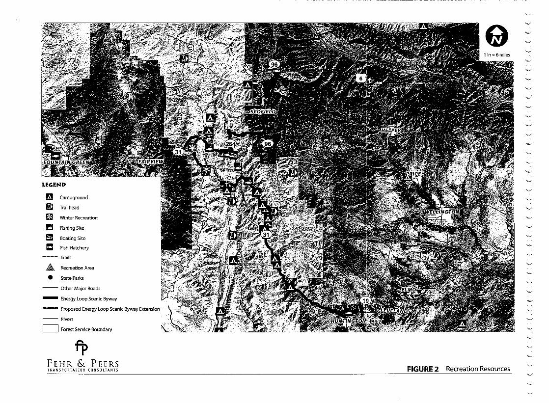
RECREATION RESOURCES Along the Energy Loop, visitors find an array of outstanding recreation opportunities which bring them back year after year. Recreation activities
16 ENERGY LOOP CORRIDOR MANAGEMENT PLAN
and opportunities are available year-round within and adjacent to the Byway. Considered by many as the most beautiful canyons in Utah, the Energy Loop
topography offers a variety of recreation activities and experiences. The list is impressive for the relatively small geographic area. The activities of fishing
(stream, lake, and ice), hunting, mountain biking, all-terrain vehicle travel, photography, berry picking, fuel wood cutting, picnicking, camping, hiking, horseback riding, driving for pleasure, boating, swimming, snowmobiling,
cross-country skiing, and snow play are all carefully managed to provide quality and memorable experiences. In addition, the intersecting 100-mile long Skyline Drive Scenic Backway and the 512-
mile long Dinosaur Diamond Scenic Byway provide access to similar recreation facilities, activities and opportunities within a few miles of the Byway.
RECREATIONAL FACILITIES
Many wonderful recreational facilities are available for use by Energy Loop Scenic Byway travelers. Several of these are described in Table 4-1.
The Huntington, Millsite, and Scofield State Parks attract thousands of visitors each year. Huntington State Park is located near the mouth of Huntington Canyon, Millsite is located 24 miles southwest of Huntington Canyon near the community of Ferron, and Scofield State Park is located near the northern terminus of Eccles Canyon. Millsite State Park is adjacent to one of the most distinctive and scenic 18-hole golf courses in the area. Palisade State Park is located in Sanpete County and also provides visitors opportunities to play golf on its 18-hole course.
Each State Park provides high-quality developed recreation facilities. These can include camp and picnic sites, beaches, modern restrooms, showers, sewage disposal, boat launching, fish-cleaning stations, and day use pavilions. During the winter months, Scofield State Park serves as a base for snowmobiling and cross-country skiing activities.
0 0
0 0!

TABLE 4-1: FACILITIES BY LOCATION
ENERGY LOOP CORRIDOR MANAGEMENT PLAN 1 7
The Price Canyon Recreation Area, administered by the Bureau of Land Management, is located on the proposed Price Canyon extension to the
Byway, north of Helper. Price Canyon Recreation Area is situated on a ridge high above the canyon, where visitors can camp and picnic among the Ponderosa pines. Hikers can take in the view of castle country and spot deer
and other wildlife during the summer and fall while the recreation area is
open.
Information on accessibility for the disabled is available at all local, state, and federal offices in the vicinity of the Byway. Camp and picnic sites, restroom
areas, and interpretive sites include features that allow good access and use by visitors with disabilities.
RECREATIONAL ACTIVITIES
There are over 50 miles of trails along the Energy Loop, with opportunities for all terrain vehicles (ATVs), motorcycles, horses, hikers, and mountain bikers. Regulations governing allowed uses are posted at most trailheads. The world renowned Great Western Trail crosses the Energy Loop at the summit of the Wasatch Plateau. This nationally significant trait running from Canada to Mexico, parallels the Skyline Drive Scenic Backway and has become an extremely popular destination trail for national and international visitors. Another popular trail is the Left Fork of the Huntington Canyon National Recreation Trail. This six-mile-long trail is located in a semi-primitive
recreation area and is closed to motorized vehicles and mountain bikes.
Winter recreation use (snowmobiling, snowkiting, cross-country skiing, ice fishing, and snow play, i.e., sledding and tubing) is increasing dramatically
within the Byway corridors. Most of this use occurs along the summit of the Wasatch Plateau, where access to "extreme" snowmobiling (snowmobiling in large open areas on flatto moderately steep terrain) and cross-country skiing is readily available. The large, open areas attract snowmobile enthusiasts from Utah and surrounding western states. The plateau's summit area is
expansive, and conflicts between winter users are minimized through the use of signs and area/trail designations. Utah State Parks and Recreation grooms snowmobile trails. Partnerships between the US Forest Service, snowmobile clubs, Utah State Parks and Recreation, local energy interests, and UDOT have provided additional restroom facilities, enlarged parking areas, and provided a building for use as a warming hut.
18 ENERGY LOOP CORRIDOR MANAGEMENT PLAN
Permitted commercial recreation uses are expanding along the Byway. Big game outfitter guides operate under permit from the US Forest Service. The
Boy Scouts of America organize a yearly "bike-a-thon" in the area, and there is also a Klondike Derby for winter sports events.
The Castle Country Travel Council has published an extensive guide on mountain biking routes throughout Carbon and Emery Counties. Several of them are accessed directly off the Energy Loop, including the Castle Valley Ridge non-motorized trail system accessed near Clear Creek on SR-96. This system of single track trails and dirt roads offers hikers, bikers, and equestrians five distinct trails that can be traveled individually or combined
to create a loop.
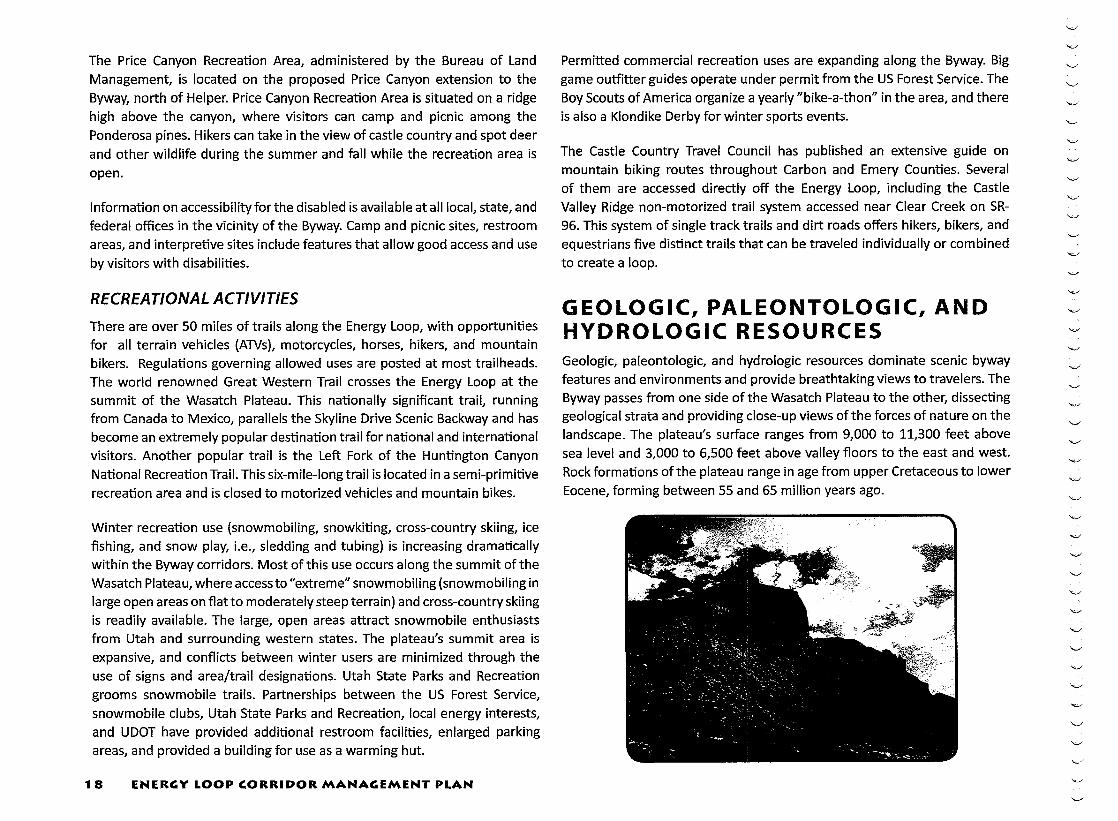
GEOLOGIC, PALEONTOLOGIC, AND HYDROLOGIC RESOURCES Geologic, paleontologic, and hydrologic resources dominate scenic byway features and environments and provide breathtaking views to travelers. The Byway passes from one side of the Wasatch Plateau to the other, dissecting geological strata and providing close-up views of the forces of nature on the landscape. The plateau's surface ranges from 9,000 to 11,300 feet above sea level and 3,000 to 6,500 feet above valley floors to the east and west. Rock formations of the plateau range in age from upper Cretaceous to lower Eocene, forming between 55 and 65 million years ago.

TABlE 4-2: TRAilS
ENERGY LOOP CORRIDOR MANAGEMENT PLAN 19

----------~~~~-
The Wasatch Plateau is one of the eight elevated tracts known as High Plateaus within the Colorado Plateau physiographic province. However, it is the only one capped entirely with sedimentary rocks. Before the uplifts of the plateau, the region was the site of meandering rivers, broad floodplains, lakes, forested swamps, beaches and offshore sand bards that formed along
the edge of mountains to the west and an inland sea to the east. The strata exposed in the eastern and western faces of the plateau as well as those seen across the plateau are the sediments deposited by these environments. Over millions of years thousands of feet of these deposits accumulated layer upon layer and preserved the fossil remains of dinosaurs fish turtles I I I
reptiles, freshwater and marine invertebrates, and mammals which were
alive at the time of their deposition. They are only exposed today because of the uplift and erosion of the plateau. The rocks are important not only from the standpoint of scenery and fossils but also for the large amounts of coal and natural gas that they contain.
Visitors will approach the summit of the Energy Loop at approximately 10,000 feet above sea level and encounter broad, "U"-shaped glaciated valleys with rounded peaks, and cirques (alpine glacier points of origin) cut and carved by ancient glaciers. Eccles Canyon traverses through these broad valleys, before entering the extension of the Green River and Price River Formations, near the community of Scofield, Utah. The eastern segment of the Energy Loop runs through Price Canyon, amid the Green River formation. The Green River formation is noted for its interbedded channels of sandstone, carbonate grainstone, marlstone, and shale. Price Canyon also contains portions of the Flagstaff Member, composed of red and gray shale, sandstone, and carbonate.
Paleontological resources within and adjacent to the Byway serve as both a source of attraction and a laboratory for scientific research and study. The several geologic formations of shales, sandstones, conglomerates, and limestone beds visible along the Byway are renowned for their unique and very important fossil mammals, dinosaurs, and lizards.
20
I I A North American Provincial Land Mammal 'Age', the Dragonian, is based on fossil mammals found in this area. Recent discoveries
indicate the great potential for significant future finds in these formations. The known fossil producing portions of the North Horn
ENERGY LOOP CORRIDOR MANAGEMENT PLAN
Formation are found only within the Manti-La Sal National Forest" (Final Environmental Impact Statement- Forest Plan, Manti-La Sal National Forest).
The paleontology of the area is interpreted at various stops, as well as at the Fairview Museum of History and Art, the Museum of the San Rafael in Castle Dale, the College of Eastern Utah Prehistoric Museum in Price,
and the Cleveland-Lloyd Dinosaur Quarry and Visitor Center just outside of Cleveland. The museums have outstanding displays of fossil mammals and dinosaurs, with explanations of their lives, times, and habits with other prehistoric creatures.
Hydrologic features, including reservoirs, lakes, one main stem river known as Huntington Creek, and many streams and springs are abundant in the corridors of the Energy Loop Scenic Byway.
Electric Lake is aptly named, in that water from the lake is used at the Huntington Power Plant at the mouth of Huntington Canyon as part of the coal-fired electric power generation. The Fairview Lakes are part of the cooperative farming operation, supplying agricultural water to Sanpete Valley. Huntington Creek and streams and springs within the Byway corridors are classified as "high quality waters" and are protected under the State of Utah water quality standards.
VEGETATIVE RESOURCES Travelers encounter an extraordinary diversity in grass, forb, brush, and tree species within the corridors of the Energy Loop. This diversity is the result
of abrupt and extreme changes in elevation (from 3,000 to 10,000 feet), and changes in soil depths, slope aspects, and climate along the Byway routes. As byway travelers ascend in elevation at the mouth of Huntington Canyon, they encounter desert shrubs, sagebrush, and grasses. Small tracts of PinyonJuniper and the distinctive Utah Juniper are encountered as travelers enter

the canyon, followed by a transition from various mountain brush species to Ponderosa Pine and Douglas Fir. In addition, a mosaic of narrow-leafed cottonwood trees, river birch, sedges, grasses, forbs, and small patches of Engleman Spruce and Douglas Fir can be seen adjacent to Huntington Creek.
Climbing in elevation, Byway travelers view spectacular forests of aspen trees, interspersed with Engleman Spruce and Subalpine Fi~ with a gradual transition to pure strands of these three species. Descending through Fairview Canyon towards the community of Fairview, expansive and breathtaking views of aspen, spruce-fir, Gamble oak, Mountain Mahogany, Sumac, and grass-covered slopes can be seen from the Sanpete Valley overlook and roadside stops along the Byway. The majority of Eccles Canyon travels through the higher elevation vegetation types (aspen, spruce, fir, and open areas of grasses, forbs, and various mountain brush
species), with the exception of the eastern end near the community of Scofield. Here, travelers encounter an abrupt change from aspen, spruce, and fir to brush and grass, streamside vegetation, and large meadows associated with watercourses leading to and entering
Scofield Reservoir. Sagebrush and bitterbrush are the major vegetative cover types in and around the reservoir. In Price Canyon, the views of Gamble Oak, Mountain Mahogany, and Ponderosa Pine return amid views of rugged canyon country, and gradually fade as travelers descend back towards Helper and the desert landscape surrounding it.
Several of the interpretive kiosks along the Byway educate the traveler on
the variety of vegetation and its importance to the ecosystem, including values on the variety of vegetation and its importance to the ecosystem. The Tie Fork Canyon interpretive site in Huntington Canyon, in particular,
draws attention to the diversity of vegetation and trees. A short hiking trail leads visitors from the site to a grove of forest greenery, home to more than twenty different species of trees.
WILDLIFE AND FISH RESOURCES The Energy Loop traverses areas on the Wasatch Plateau that are ranked by the Utah Division of Wildlife Resources as the number one location in Utah for production of the big game species of deer, elk, and moose. Wildlife production thrives
in the area due to the high quality habitats found in the diverse forested slopes, canyons, and largeopen meadow areas along the crest of the plateau. In addition, streams, lakes, reservoirs, Price River, Huntington Creek, and the Left Fork of Huntington Creek are extremely popular fishing attractions for anglers from throughout the nation. In fact, Huntington Creek is recognized by the State of Utah's Division of Wildlife Resources as a blue ribbon fishery, indicating a location of particularly high quality and scenic fishing opportunities. Huntington Creek is best known for brown and cutthroat trout (the Left Fork) and brown, cutthroat, and rainbow trout (the Right Fork). The Price River, or lower Fish Creek, is also identified as a blue ribbon fishery, from US-6 to the Scofield Dam along the Energy Loop. Anglers can
fish for brown, rainbow, and cutthroat trout in the Price River. Furthermore, two of Utah's State Parks (Huntington and Scofield) are located adjacent to the Energy Loop, and each has managed to provide quality recreational fishing experiences. Millsite State Park also provides an attractive fishing experience and is located approximately 24 miles south of the eastern end of Huntington Canyon.
The Byway also provides the opportunity to see and learn about the wildlife
of millions of years ago. The Byway routes are in close proximity to the Cleveland-Lloyd Dinosaur Quarry, the College of Eastern Utah Prehistoric Museum and the Museum of the San Rafael Swell. The museums have outstanding displays on the lives and habitats of the region's earliest wildlife species- the dinosaurs of the Jurassic Period. One of the interpretive sites along the Energy Loop highlights the 1988 discovery of a prehistoric Columbian
ENERGY LOOP CORRIDOR MANAGEMENT PLAN .11

mammoth skeleton, buried in black muck in the nearby Huntington Reservoir area. The skeletal remains of a short-faced bear and a few primitive stone tools of the same prehistoric time period were also discovered in the same area. The interpretive display attracts hundreds of visitors each year who are fascinated by the story of the Huntington Mammoth, including the scientific
interpretation of how the mammoth found its way to the area where it eventually perished and was covered by the debris of time.
Byway travelers frequently see deer and elk, especially during spring and fall months as these animals cross Byway corridors on migration routes from
summer to winter habitat. Beaver dams and the elusive beavers themselves can be seen along tributaries to Huntington Creek. These lush riparian areas are also important habitat of numerous neotropical migrant birds, providing
bird-watching opportunities during spring, summer, and early fall months. The majestic birds of prey, such as the golden and bald eagles, peregrine
falcons, and red-tailed hawks not only migrate through the area, but often nest in the numerous side canyons, rugged outcrops, and spires of limestone and sandstone. Bears and mountain lions, although few in number, can be seen roaming the forested areas and foothills of the plateau.
VISUAL RESOURCES One of the recommendations frequently made by Utah tourism specialists to visitors is to take the time to travel the state's scenic byways. Visitors are never disappointed with the recommendation, for as they travel the scenic byways, they are spellbound by the diversity in contrasting landscapes, vegetation patterns, colors, expansive view of mountains and valleys, stream and lake environments, and compatible multiple uses.
The existing seventeen scenic bywaydesignated interpretive sites alongthe Energy Loop are located where this outstanding scenery is most visible and highlight the vistas with both interpretive messages and pleasing site designs. Each site is designed
22 ENER~Y LOOP CORRIDOR MANA~EMENT PLAN
with turnouts, parking spaces, and displays. Restroom facilities are located at some of the sites at appropriate intervals along the way.
Steep and colorful cliffs "greet11 visitors in the eastern portion of the Energy Loop. Lush streamside vegetation, clear flowing water, and inviting side
canyons are found in Huntington Canyon. The visual focus then gradually changes from a canyon environment to large, open areas in a sub-alpine setting, with expansive views of lakes and mountain peaks as the Byway nears the junction of Fairview Canyon, Eccles Canyon, and Huntington Canyon. The slopes along the western end of this scenic byway focus the attention to the green Sanpete Valley below, including vistas of various communities and farmlands dotted along the valley in a north-south direction. Fairview Canyon winds its way down these slopes, with each turn providing exciting
views of forested side slopes interspersed with open grassy areas and mountain brush. The Byway then passes through irrigated farmland and
ranches as it approaches the historic community of Fairview.
At the summit of the plateau, the Byway traverses through marvelous subalpine scenery, dotted with lakes, aspen and spruce-fir trees, and glaciated basins sometimes filled with the previous winter's snowfall. The Byway passes through the picturesque community of Scofield and past Scofield State Park. Here, travelers encounter vistas of farmland, bounded by forested slopes on one side and open range on the other, with the 2,800-acre Scofield Reservoir framing the scenic views. The Price Canyon section of the Byway runs past the Price Canyon Recreation Area and overlooks the
magnificent rugged canyon country and flowing
waters of the Price River.
BACKCOUNTRY LOOP ROUTES
There are extraordinary opportunities to explore the backcountry on Scenic Backways, accessed directly from the Energy Loop or surrounding highways. Scenic Backways are gravel or dirt roads that access more remote destinations. For example, Skyline Drive is a 100-mile long Scenic Backway that intersects
the Energy Loop along the summit of the Wasatch Plateau. Views of large open areas,
""''
"'-''
"-''

lakes, ponds and streams are common along this Scenic Backway. In addition, travelers along Skyline Drive can view portions of the Great Basin to the west of the Colorado Plateau and Uintah Basin to the east, including the San Rafael Swell and Book Cliff areas, and the Wasatch Mountain ranges to the north. More opportunities for backway routes are recommended in the "Byway Improvements and Implementation" section of this CMP.
The Manti-La Sal National Forest has over 350 miles of designated ATV and
4x4 routes. This trail system is known as the Arapeen OHV Trail System. While not all of the trail system is located within the Energy Loop corridor, the entire system is accessible not far from the Byway.
CULTURAL AND HISTORIC RESOURCES Few areas in the United States have as much diversity in cultural and historic resources as the areas crossed by the Energy Loop. The area is like an open book, with the pages represented by existing prehistoric artifacts and sites, the architecture of early settlers, and remnants of the lifestyles of the old and new West.
PREHISTORIC PEOPLES AND NATIVE AMERICAN USE
The valleys and canyons on the eastern portion of the Byway are known today as the Wasatch Plateau, and were traveled and inhabited by three principal prehistoric peoples. Paleo-Indian cultures made the area home with habitation dating back to 8,000 B.C. These cultures were followed by the Archaic people. Most of the prehistoric evidence in the area represents the third group, known as the Fremont Culture, with occupation between A.D. 400 and A.D. 1250. The three prehistoric groups used the forested slopes and canyons of the plateau as hunting and gathering grounds. The Fremont Culture was agriculture-based and people of this culture used the
lower area of Huntington Canyon to grow crops such as corn. This culture was followed by the historic Native Americans known as the Ute/Paiute
Indian groups, who again inhabited the valleys east and west of the plateau region, frequenting the plateau to hunt wild game, such as deer, mountain
sheep, and elk.
Source: Bill Bryant, http://flickr.com/photos/bryant99/
The nearby San Rafael Swell and the Nine Mile Canyon Scenic Backway areas are nationally known for extensive rock art panels and numerous rock shelters and pit houses of the Fremont Culture. Over 1,200 sites are found in the Nine Mile Canyon area alone. Visitors will see petroglyphs (designs carved into the rock) and pictographs (painted figures) along roads that travel through these areas. Interpretive sites exist along travelways within both the San Rafael Swell and Nine Mile Canyon. These sites provide visitors with unique experiences where they can almost feel the presence of this ancient culture. One local brochure appropriately interprets the sites of the San Rafael Swell as "Echoes of the Past". Although the forested and canyon areas of the Wasatch Plateau were seldom used for long-term habitation, evidence of rock art and pit houses have been found in several canyon areas south of the Byway.
EARLY EXPLORERS AND SETTLERS
The area surrounding the Energy Loop is locally labeled the "Land of Three Heritages." In 1849, Mormon pioneers migrated and settled in the valley areas along the western slopes of the plateau, and eventually settled the
Castle Valley area on the eastern side of the plateau. Starting in the 1890s, the Castle Valley area and its predominant Mormon population witnessed the beginning of the "second heritage" as immigrants from mostly southern
and eastern European countries moved in to the region. There was a steady stream of diverse ethnic groups until the immigration restriction acts of the
ENERGY LOOP CORRIDOR MANAGEMENT PLAN .13

1920s. The "third heritage/' the mining era, was the period in which the coal mining industry became established as the principal sector of commerce in the region.
The recent immigrants from Greece, Italy, Austria, Yugoslavia, and other European countries provided the labor force for the coal mining industry.
This extraordinary historic heritage event is captured for all visitors to experience at the Western Mining and Railroad Museum located in Helper,
Utah, located on US-6, at the proposed eastern termini of the Energy Loop. This museum dramatically displays the trials, tribulations, tragedies, and
joys of the coal miner's life in pictures, stories, and models.
The prehistoric and historic resources of the area render a rich, almost magical feel to the area. Visitors can almost hear (and sometimes do) the long ago sounds of horses, wagons, coal-fired train engines, railroad cars, and as many as ten or more different spoken languages. As visitors travel to and along the Byway, they see and experience the past at almost every bend in the road. The "painted" canyons considered sacred by prehistoric peoples and Native Americans; the early Mormon homesteads with rustic cabins and old farm machinery scattered on historic farmland; and most evident, the historic mining camps and towns all provide a memorable experience to the visitor. Today, Fairview is the starting point not only for the Energy Loop, but also for the Mormon Pioneer National Heritage Area. Formally recognized in 2006, the Mormon Pioneer National Heritage Area acknowledges the influence of the Mormon culture in a 250-mile-long corridor along US-89, from Fairview to the Utah-Arizona border. Visitors to the National Heritage Area can learn more about the region's history, from the farming and ranching lifestyles of the Mormons to the outlaws and trappers known for plying their trades throughout the West.
Visitors to the Energy Loop have numerous and exciting choices and
opportunities to learn about cultural and historic resources. Four museums, numerous annual celebrations, and expertly designed self-guided tours are available throughout the year, and each event is advertised in regional and national publications. The College of Eastern Utah Prehistoric Museum in Price, the Museum of San Rafael in Castle Dale, the Fairview Museum of History and Art, and the Western Mining and Railroad Museum in Helper
24 ENERGY LOOP CORRIDOR MANAGEMENT PLAN
provide excellent visitor information services about the Energy Loop, including maps, brochures, and lodging and restaurant information. These
museums are located either on the Byway or on highways leading to the Byway. The Castle Country Regional Information Center, located within the College of Eastern Utah Prehistoric Museum in Price, also has exceptional displays on a variety of topics.
INDUSTRIAL RESOURCES The Energy Loop is located in the region of Utah that is a major supplier of high quality coal, oil and gas, and electric power to the western States. The Byway forms a loop around an area where there are coal mines, oil and gas wells and pipelines, and three of the major electric power plants in the western United States (Hunter, Carbon, and Huntington Power Plants).
The Western Mining and Railroad Museum in Helper has remarkable displays of the growth of these industries in central Utah. A tour of this museum takes visitors back in time to the late 1800s when coal was first discovered, then on through the early 1900s when railroad companies controlled and developed the first coal camps in the area. The museum also displays the development of the industry from the past to the present, including changes in equipment, safety measures, and the general welfare of the miner.
At the peak of mining activities, there were more than 30 mines in operation, many of which were supported by adjoining coal camps, which were usually
a haphazard arrangement of housing, barracks, stores, shops, and other support facilities. Today, there are six mines in operation, with miners living in the communities surrounding the Byway. Several of these mines are along the Energy Loop. There is also a proposed mine located just south of the Scofield Reservoir. The one extensive railroad system is now limited to the Price and Helper areas, with spur lines leading to few coal mine operations. Most of the coal is now transported by large trucks or long conveyor belts
from the mouth of the mines to nearby railroad loading areas.
Visitors are amazed upon seeing the Hunter and Huntington Electric Power Plants as they approach the Energy Loop Scenic Byway. The Carbon Electric Power Plant greets visitors at the intersection of US-6 and SR-191 near
,_,.

Helper, along the proposed Price Canyon extension of the Energy Loop. The power plants burn coal to produce electrical power. All three are owned by Utah Power, a subsidiary of Pacific Power Corporation (PacifiCorp).
Large 238 kV and 345 kV transmission lines carry the electrical power to centrally located substations in the western United States. All three power plants are considered critical power sources for the electrical matrix
system of the western United Sates. In addition, Utah Power is conducting experiments on ways to use their industrial water for growing clean and
healthy crops.
Natural coal bed methane gas fields have been developed in expansive areas south of Price, and numerous gas well sites are visible along Highway 10 en route to the community of Huntington. The natural gas is transported by pipeline to large transmission systems running through Utah between the
states of Texas and Washington.
A natural gas field also exists north of the community of Fairview on the western side of the Wasatch Plateau, and pipelines transport the natural gas from these fields to communities in central and southern Utah. Undeveloped
natural gas fields exist in the central section of Huntington Canyon and within the eastern third of Eccles Canyon. There is only one gas-producing well within the Byway; this well is located south of the community of Scofield,
within view of the Energy Loop.
The history of industrialization in the area is documented in many publications. This history is a good example of the industrial movement in the United States during the late 1800s and the beginning of the twentieth century. The stories of this era are sometimes sad, always colorful, and cherished by the long-term residents of eastern Utah. The Energy Loop brings the history to life and serves as an important medium linking the past
to the present.
ENERGY LOOP CORRIDOR MANAGEMENT PLAN 2 5
LEGEND
~ Campground
I!D Trailhead
Bl Winter Recreation
!!J Rshing Site
5I Boating Site
ICI Rsh Hatchery
----Trails
.£ Recreation Area
e State Parks
--- Other Major Roads
- Energy Loop Scenic Byway
- Proposed Energy Loop Scenic Byway Extension
---Rivers
c=J Forest Service Boundary
fl> FEHR & PEERS TRANSPORTATION CONSULTANTS FIGURE 2 Recreation Resources

~ Guard Station
Significant Land Forms
• • • Wildlife Management Area
Monument
Waterfowl Management Area
Forest Service Boundary
AshleyN.F.
Manti-La Sal N.F.
Uinta N.F.
--- Other Major Roads
- Energy Loop Scenic Byway
- Proposed Energy Loop Scenic Byway Extension ,
---Rivers
tp FEHR & PEERS TRANSPORTATION CONSULTANTS FIGURE 3 Natural Resources

~ Coal Mine Locations
- Energy Loop Scenic Byway
- Proposed Energy Loop Scenic Byway Extension
Other Major Roads
Rivers
111111 DNR Oil Gas Fields
fP FEHR & PEERS TRANSPORTATION CONSULTANTS FIGURE 4 Mining Resources

c
c c
---------------------------- -----------


5: RESOURCE MANAGEMENT AND PROTECTION
The Energy Loop is regarded as an outstanding example of Utah's beautiful forested landscapes. The Byway corridors are destination sites for regional and national visitors who desire to see expansive views of a variety of western landscapes, including views of the Great Basin, Colorado River Plateau, and the Wasatch Mountains. The combination of lush vegetation, extensive views and unlimited outdoor recreation opportunities makes the Byway a special tourism and recreation attraction. Due to the intrinsic resource values, careful management of the Byway is a priority for county, community, state, and federal officials. The resource management strategies in this chapter address implementation of the existing agreements and goals, particularly for the intrinsic visual, wildlife, historic, cultural, and recreation resources.
AGREEMENTS The Energy Loop is managed, marketed and promoted as directed by the Energy Loop Scenic Byway Committee. This committee is comprised of representatives from local, state, and federal government groups, industry (coal, oil and gas, and electricity), local businesses, private land owners,
irrigation companies, and concerned citizens. Committee members understand the importance of a coordinated resource management approach. Agreements are in place to guide and direct program planning and implementation of activities and actions within the Byway.
The goal of these agreements is to protect Byway qualities while meeting the needs of people who have historically used and been dependent upon the land and water resources within the corridors. Committee members
place high value on the existing resources, including associated social and economic benefits, and they support management strategies that will protect and enhance the Byway's intrinsic qualities. Due to their experience
in land management these members also know that mining, oil and gas development, grazing, timber harvesting, and other land and resource uses can continue as practices on land adjacent to (and sometimes within) the Byway, without short- or long-term impairment to natural resource qualities.
The maintenance and enhancement of the Byway will be accomplished by utilizing a variety of existing land use polices for planning, design, conservation, protection, and implementation. Historically, federal, state, and local government agencies and groups have managed the Byway according to their own guiding management documents.
LAND STATUS Close to half of the Energy Loop is located within the Manti
Division of the Manti-La Sal National Forest and under the jurisdiction of the USDA Forest Service. Segments of the Byway on the eastern and western sides of the Wasatch Plateau are under USDI Bureau of Land Management, private, county, or city jurisdiction. Lands, reservoirs, and summer homes along the summit of the Wasatch Plateau (referred to as the Fairview Lakes) are under either private ownership or ownership of irrigation companies. The portions of the Byway near Huntington, Scofield, Fairview and Helper also pass by private property in those municipalities. Both Huntington and Scofield State Parks are located within the corridors and are managed by Utah State Parks and Recreation. The Price Canyon Recreation Area is managed by the USDI Bureau of Land Management. The USDA Forest Service, USDI Bureau of Land Management, Utah State Parks and Recreation and private land owners cooperate with the Utah Division of Wildlife Resources in managing fish and wildlife species within and adjacent to the Byway.
GOVERNING REGULATIONS Several documents compiled by the USDA Forest Service and other agencies provide guidance on forest-related matters. The basic planning document for the area encompassing the Energy Loop in the Manti-La Sal National Forest is the Forest Service's Land and Resource Management Plan (LRMP) and accompanying Final Environmental Impact Statement.

This document provides overall direction for visual and other resource management considered critical to the success of scenic byway protection
and enhancement. A revision of the plan is currently being conducted. Document information on the LRMP can be found in the References section of this CMP.
Environmental impact statements for coal and gas mining as well as highway improvements have also provided valuable information and direction on the Energy Loop. New coal leases and potential coal mine developments were assessed in a "State of Utah Coal Tract Environmental Impact Statement", dated 1985. This EIS and the Record of Decision mandate both general and specific direction for the development of new coal mines, including environmental protection measures. As mentioned previously, existing coal mine operations are regulated by the Mineral Leasing Act of 1920, as amended and associated regulations.
In 2005 a Final Environmental Impact Statement (FEIS) wascompletedfor US-6 between Interstate 70 and Interstate 15. This document identified the need for additional travel lanes and safety improvements due to growing travel demand and frequent traffic accidents. The segment of US-6 included in the Energy Loop is between the junction with SR-96 near Colton and the Town of Helper (approximately mileposts 216 and 233). The FEIS recommended improvements to horizontal curves in Price Canyon, additional climbing lanes, center rumble strips or median barrier, and relocation of the Peerless Port of Entry. The environmental impact document was completed for 61 miles of roadway; due to limitations in available funding, improvement
projects will be built over time based on priority.
Areas within the Byway under jurisdiction of city and county agencies have regulatory protection strategies as part of local zoning regulations. These regulations guide the development, operation, and expansion of land uses that take place within local communities and counties bordering the Byway. Land in Price Canyon north of Helper is subject to Carbon County zoning jurisdiction. The lands along the highway in Price Canyon are zoned "M&G", or Mining and Grazing Use. SR-96, which is the portion of the Byway in Carbon County from Colton to Scofield, is primarily zoned as "WS", or Water Shed zone. SR-31 in Huntington Canyon is part of Emery County and subject to its zoning regulations. The lower reaches of Huntington Canyon, outside
3l. ENERGY LOOP CORRIDOR MANAGEMENT PLAN
of Huntington itself, are zoned as A-1 (Agricultural) or M&G-1 (Mining and
Grazing). In the upper reaches of the canyon, SR-31 is zoned as M-1, or Mountain. The extension from SR-31 along SR-10 to Huntington State Park is primarily zoned as industrial. SR-31 east of Fairview is in Sanpete County, and traverses through the Residential-Agricultural (RA-1 and RA-2), Agricultural
(A), and Sensitive Lands (SL) zones.
CULTURAL AND HISTORIC RESOURCES The Byway and nearby region have numerous special cultural and historic
resources, including paleontological sites, prehistoric rock art and shelter sites, abandoned coal mines and coal camps, and historic town sites and
community centers. As development and improvements occur throughout the corridor, particularly on state and federally administered lands, potential cultural and historic sites and artifacts will be inventoried and assessed according to the standards established by the agency and consistent with
the Advisory Council on Historic Preservation.
The Byway Committee will advocate for classification of sites or artifacts on state and national historic registers and, when appropriate, request that they not be transferred, sold, demolished, or altered. In consultation
with the State Historical Preservation Office, evaluation will be made of any archaeological or historical sites or structures located by cultural resources inventories or discovery. Those sites will be considered for eligibility for the National Register of Historic Places. The Byway Committee will also work closely with local preservation and special interest groups to collaborate on the sensitive identification, interpretation and development of these resources for the traveling public's viewing pleasure.
Publications on selected prehistoric rock art and historic sites are available to the public at all visitor contact points. These publications provide recommendations and regulatory information for preserving the character of cultural and historic sites.
0 C)
0 0

c
c c
RECREATION RESOURCES AT STATE PARKS AND COMMUNITY PARKS
Utah State Parks and Recreation administers the Huntington and Scofield State Parks. Exceptional facilities and a variety of recreation opportunities are provided, such as: camping, boating, fishing, and biking. Management plans for each Park include general policy and specific direction for
developing, enhancing and maintaining recreation and visual resources.
ENERGY LOOP CORRIDOR MANAGEMENT PLAN J3


6: HIGHWAY SAFETY AND MANAGEMENT The Energy Loop is composed offive state roads totaling about one hundred miles, and encompasses an area of nearly 550 square miles. These winding roadways begin in valleys below the Wasatch Plateau and climb nearly 4,000 feet to reach elevations of over 10,000 feet. SR-31 ascends from the city of Fairview in Sanpete Valley, traverses the plateau for several miles, and eventually descends Huntington Canyon in northwest Emery County. The Byway continues on SR-10 for a short distance to access Huntington State Park. From the east, SR-96 and SR-264 climb from US-6 to intersect with SR-31 on the plateau near the top of Huntington Canyon. From the junction with SR-96, US-6 descends Price Canyon to the City of Helper
where the extension of the Byway designation ends.
A drive along the total length of the Energy Loop will reveal several features that contribute to safe conditions for a roadway of this nature:
• Sight distances are moderately good, but extra caution should always be used on curves and near driveways at mining and power plant operations;
• Roadway surfaces are regularly maintained along the entirety of the Byway; and
• The Utah Department of Transportation clears snow during the winter season.
However, as is inherent of many mountain and canyon roadways, there are some conditions that might create traffic safety concerns, including:
• Severe roadway geometries such as sharp horizontal curves and steep grades;
• Limited visibility near pullouts, interpretive sites, and recreational areas;
• Limited guardrails near steep drop-offs;
• Slick road conditions from snow, ice, and shade, which may only be present at higher elevations;
• Semi-annual transport of livestock on the roads and open grazing;
• Abundant wildlife, which occasionally cross the road;
• Industrial mining and energy operations generating significant heavy truck traffic.
This combination of winding roads, variable climates and landscapes, an active multiple-use management strategy that supports mining operations, grazing, and timber sales, the presence of commuter traffic (regional workers
traveling to energy-related jobs and other workplaces), and increasing tourism traffic can create challenging safety concerns for the Byway.
COMMERCIAL TRUCK TRAFFIC Commercial truck traffic is an important element of the Energy Loop. The activity and vibrancy of the local mining operations is directly linked to the large trucks hauling coal to the power plants. In some ways these vehicles are the most visible symbol of the local economy. However, for Byway visitors seeking a wilderness experience in the Energy Loop these trucks may be perceived as intrusive, noisy, or dangerous.
The USDA Forest Service has issued permits to six mining operations located along the Energy Loop, four of which are accessed from SR-31, one
from SR-96, and one from SR-264. These mines generate ongoing trucking shipments of coal on a constant basis. The Huntington Power Plant is located on the eastern end of Huntington Canyon; in addition to truck
deliveries, coal is transported from the Deer Creek Mine via a conveyor system. Because the coal trucks are large and are unable to quickly stop when fully loaded, they are a potential hazard on the Byway. However, coal trucks do not normally drive the total length of any Byway segment,

with the highest concentration of truck traffic limited to a short stretch at the entrance of Huntington Canyon on SR-31.
The Energy Loop routes are also used by commercial trucks that are simply
passing through, beginning and ending their trip outside of the Energy Loop area. This regional truck traffic, in conjunction with locally generated trucks,
comprises a high proportion of total Byway traffic. Truck traffic data from UDO~ illustrated in Figure 5, indicates that trucks account for 18% to 28% of total traffic on the Energy Loop, with a considerably smaller percentage of truck traffic on SR-264. Looking ahead, changes in locally-generated trucking activity will be dependent on mining activity. For the foreseeable future it is unlikely that truck traffic will decrease, as the mines are a key component of the local economy. Data from UDOT's Statewide Travel Model suggests that regional commercial traffic (pass-through trips) will increase by about
one percent annually on SR-31, SR-96, and SR-264. Due to its function as a regional connector, US-6 is likely to experience higher levels of growth in truck traffic at about two percent per year.
Timber sale operations take place in various locations of the Wasatch Plateau, both on Forest Service lands and on private in-holdings. The Forest Service works to manage their timber operations and fire wood cutting in the Byway
36 ENERGY LOOP CORRIDOR MANAGEMENT PLAN
and carefully plans and monitors these activities, usually allowed only for harvesting dead or unsafe trees that pose hazards for recreational site
users. Private timbering operations make up the majority of logging traffic experienced along the Byway. Travelers along the Byway may encounter large trucking rigs hauling timber and special attention and care should be made by the traveling public.
COMMUTER TRAFFIC The power plants and coal mines within the Energy Loop are regionally significant employment centers, drawing commuters from the surrounding communities. Much of this commuter traffic occurs on SR-31, which directly connects the communities in the Sanpete Valley to employment in Huntington Canyon. Commuters are more likely to value travel time and less likely to visit interpretive sites regularly.
TOURISM TRAFFIC The Energy Loop experiences a variety oftourism-related traffic. Automobiles, trucks, recreational vehicles, motorcycles, motor coaches and buses all use these routes as a scenic drive or destination. As previously stated, frequently travelers on vacation are distracted or are not operating their vehicles under normal conditions (packed vehicles, pulling trailers, bicycle racks, maps and brochures on the dashboard, etc.). Traffic reaches its peak during the summer months, during the fall color changes, and during hunting season.
Existing tourism attractions and services along or near the Byway include
Scofield State Park, Skyline Drive Scenic Backway, Huntington Creek Blue Ribbon Fishery, Tie Fork Canyon trailheads, Electric Lake, and the Stuart Guard Station Visitors Center, some of which received federal funding for improvements to roadside interpretive kiosks. These improvements typically include new signage, parking, and restroom facilities. Further improvements
are also proposed as part of this CMP update.
0 0
Visitors traveling along the Byway have opportunities to view state-of-the- ,_, art mining and power plant operations, and many will seek out information "--' on how this is interpreted. They will be intrigued by the view of the "---' large industrial architecture of the twin stack power plant at the mouth "-"
0 0

~ 2008 Average Daily Traffic
~ 2008 Average Truck Traffic Percentage
--- Other Major Roads
- Energy Loop Scenic Byway
- Proposed Energy Loop Scenic Byway Extension
---Rivers
tp FEHR & PEERS TRANSPORTATION CONSULTANTS
Source: UDOTTruckTraffic on Utah Highways (2008) Peerless Port of Entry (201 0)
FIGURE 5 Existing (2008) ADT & Truck Traffic

of Huntington Canyon as well as the unique mining complex and winding conveyor system found at the coal mining operations in Eccles Canyon.
Roadside interpretive stops at the Skyline Mine, the historic town of Scofield, at Electric Lake overlook and across from the Huntington Power Plant will educate the public about the important role energy plays in their lives, the current management efforts to protect and enhance the environment during production and reclamation, changes that have occurred in the industry and the history of early operations. Travelers will also have opportunities to further explore energy-related topics after they leave the Byway and
travel throughout the corridor to nearby communities such as Helper, Price, Huntington and Castle Dale.
SAFETY AND ACCIDENT REVIEW
Crash records were obtained for the Byway to identify problem areas and commonalities among the incident types. This information is useful to understand what safety improvement strategies are appropriate, and where they might be considered. By reviewing police reports that describe the situational elements of an incident (i.e. collision type, date, time, number of vehicles involved, injuries), UDOT estimates annual crash frequency and severity rates for each of its roadways. These two measures are normalized by accounting for the annual average daily traffic (AADT) and route length; this indicates that roads with high traffic volumes will experience a proportionally higher number of accidents simply because there is more vehicle travel on these roads.
The annual average crash rate is the number of crashes per million miles of travel on the road. The annual average severity represents the average severity of the crashes, measured on a scale of 1 to 5 with 1 being "property damage only" and 5 involving a fatality. Since the majority of incidents involve property damage only, most roads have an annual average severity between 1.5 and 2.5. UDOT expects a certain crash and severity rate on each of its roadways, based on its experience managing and monitoring many types of roadways with a variety of traffic levels. If the expected crash rate or severity is higher than expected, that means that the road experiences a higher frequency and/or severity of incidents than other similar facilities, and safety improvements may be needed.
JS ENERGY LOOP CORRIDOR MANAGEMENT PLAN
----- ~----. --~----~
SR-31 crash records indicate 104 recorded accidents during the three year period from 2005 to 2007. Given the route length, AAD~ and roadway
functional class, SR-31 experiences fewer and less severe crashes than expected.
The most common crash elements on SR-31 involve collision with a wild animal (29%) or domestic animal (5%), roadway departure (44%), and are
speed related (32%).
A higher proportion of recorded crashes occur in Fairview Canyon roughly between mile post four and seven and in Huntington Canyon between
approximately mile post thirty-nine and forty-five. The steep grades, blind curves, and narrow shoulders create challenging driving conditions in Fairview Canyon, particularly during the colder season when snow and ice form on the Byway. In Fairview Canyon most crashes involve only one vehicle, almost half are associated with excessive travel speed, and more than a third involve slick road conditions.
·~.······~ ~:>_6_~:ot cr9cshes involve snow, slush, or ice on road !~~~7;% ~f. crashes, driver was going too fast for conditions
.· :?~Qf ~r.e~hg~ <J[e involv~ only one vehicle
CARBON
~-:.oi.cr,<;;;*~~~-or ~o_mestic.ani~als g'!g:Qf.£1:.~Q~!!!Y_DLv~ (Jniy,one v.eh1qle ~--~-
LEGEND
Vehicle Accidents
0 0-3
• 4-6
• 7-10 D. • 11 N

TABLE 6-1: UDOT HIGHWAY SAFETY STATISTICS FROM 2005-2007
96 22 456 22 1.38 1.81 2.04 2.41
Note: SR-96 data is from 2006-2008
ENERGY LOOP CORRIDOR MANAGEMENT PLAN 39
------ --------------------------------------

-------------~---~-~~~~~~~-~·-·---- -- -~--~~
The lower portion of Huntington Canyon features more traffic, particularly commercial trucks associated with the local mineral extraction operations.
The majority of the crashes through this section involve only one vehicle, and frequently the crash is caused by collision with a wild animal. Although less common, several incidents involving domestic livestock have also been
recorded. While SR-31 is not free of collisions, it is noteworthy that the actual crash and severity rates are considerably lower than the expected rates for SR-31. This indicates that safety is of low to moderate concern on SR-31.
Crash Type US 6 MP 216-233
~.----------
~%~---~------~
30%~---~--25%~---~--
20%+-----~
15%~---~--
10%
5%
0%
Many of the accidents on the Price Canyon segment of US-6 involve vehicles departing from the roadway, possibly caused by driver inattention, sharp horizontal curves, debris or rockfall, and excessive travel speeds. Roughly 31% of all accidents involve wildlife strikes; there were 73
recorded accidents involving wildlife during the three year period. Of these accidents, only one resulted in personal injury and none resulted in human fatalities. During the same time period, three incidents involving human fatalities occurred; two of the incidents were caused by a vehicle crossing over the median into oncoming traffic, and one was caused by a roadway departure.
Incident records suggest high frequency of crashes between mileposts 222 and 224. This segment represents 17% of the US-6 segment by mileage, but accounts for 34% of recorded accidents recorded accidents from 2005 through 2007. Similar to SR-31, actual crash and severity rates on US-6 are lower than expected, indicating that safety is a relatively minor concern on this segment of the Byway.
UDOT is already planning to make capacity and safety improvements on US-6, including the proposed Price Canyon extension of the Energy Loop Scenic Byway. Expected improvements include a full four lane cross section
and adjustments to horizontal curves that do not meet current design standards. Center and shoulder rumble strips already exist throughout
40 ENERGY LOOP CORRIDOR MANAGEMENT PLAN
this Byway segment to help address crossover and roadway
departure crashes. Slope stabilization efforts will reduce rock fall and corresponding
road debris. To address wildlife collisions UDOT has installed wildlife fencing and under-crossings on US-6; this treatment may be effective on other Byway segments as well. Pullouts are generally not appropriate throughout much of this segment due to relatively high travel speeds (60 mph) and traffic volumes. However, in Price Canyon near milepost 229 there is an
39% of crashes involve wildlne strikes 40% of crashes involved departure from roadway 78% of crashes involve only one vehicle
CARBON
LEGEND
Vehicle Accidents
• 0-10
• 11-20 ~ • 21-30 N
• 31-36
2008 Average Daily Traffic
informal pullout with existing interpretive signs and a scenic view of the canyon and power plant. This location is ideal for a pullout because it can accommodate numerous vehicles and has adequate sight distance to allow safe ingress and egress. According to UDOT Administrative Rule R930-6, the following access improvements are required if traffic volume warrants are
met:
• a left turn deceleration lane is required if peak hour left turn ingress turning volume is greater than 5 vehicles per hour;
• a right turn deceleration lane is required if peak hour right turn ingress turning volume is greater than 10 vehicles per hour;
• a right turn acceleration lane is required if peak hour right turn egress turning volume is greater than 10 vehicles per hour;
• a left turn acceleration lane may be required if it will be a benefit to the safety and operation of the roadway.
UDOT and the Energy Loop Scenic Byway Committee should monitor traffic
volumes at this pullout, to determine whether access improvements would
be warranted according to the rules outlined above.

Crash Type SR-,264
=- 80% g ~ 70%
! 80%
! 50%
40%
~ 30% 0 20%
1 10% • • • a. 0%
'fiP'b -~0 !!' ~., Q.;S- ~~.? /<§> ~$i" ~cg.~ If~ of
,p<f> ~~ ;;.<!' 0'<' /'<' ~ r?~
<;; <!"'' ,# ~,# <( ... ~
Source: UDOT SMS SUmma UstJno Crash T Su rna Reoort 2005-:2008 Printed!l/30/09
I
There were a total of 13 vehicle accidents on SR-264 from 2005 through 2007. Most of the accidents on this 15-mile highway segment involved single-vehicle roadway departures. There appears to be a relatively high
frequency of reported injuries, as indicated by the high annual average severity index. This high
rate of injuries could be related to the frequency in which excessive speed was a contributing factor, coupled with the mountainous terrain with steep dropoffs. Unlike other segments of the Byway, no collisions involving animal strikes were reported.
There were a total of 24 vehicle accidents on SR-96 between 2005 and 2008. As with the other mountainous Byway corridors, most of the accidents (79%) involved only one vehicle. 42% of accidents involved an animal strike, and only 17% of incidents were reported to involve excessive speeds. There appears to be a higher frequency of collisions roughly between mileposts 14 and 15 which corresponds to the north end of Scofield Reservoir. This area has a higher
concentration of driveway access for private homes and the Scofield State Park facilities, however
these incidents were not reported in association with a roadway intersection. Revisiting this analysis within five to ten years may reveal more information and clarify collision patterns in this segment.
HIGHWAY SAFETY MANAGEMENT STRATEGIES Successful management of the Byway corridors will include strategies that enhance safety, improve the driving experience, and mitigate conflict between commuters, commercial vehicles, and Byway visitors. At this time there is little need for major highway construction, but some general design
elements should be considered to proactively address known or anticipated issues. Major future highway improvements will be influenced by future trends in tourism-related visitation, mineral extraction activity, regional trucking routes, and commuter patterns. Below is a list of recommended management practices.
MAINTAIN SAFE ACCESS TO VISITOR SERVICES
Existing and future interpretive sites, view areas, and similar visitor facilities should provide right- and left-turn lanes where practical. These elements
will reduce the speed differential between turning and through vehicles and minimize rear-end accidents. If there is limited sight distance due to horizontal or vertical curves, acceleration lanes should be considered to help travelers re-enter the Byway. Vegetation that limits sight distance should be managed where practical.
Advance warning signs announce points of interest to travelers and provide more time to safely signal, decelerate, and exit the roadway. These signs, erected for each direction with both distances and locations (which side of road), serve to alert Byway traffic of upcoming activity centers where there may be pedestrians and other vehicles entering or exiting the highway.
As the Byway adds new informational and interpretive elements along the route, carefully select sites that have safe sight distances for deceleration and turning maneuvers and adequate space for parking. At existing sites,
improve the roadway to make each site safe for vehicles entering and exiting
the site, as well as for pass-by traffic on the roadway. These concerns should be considered for the interpretive sites proposed in this CMP update.
ENERGY LOOP CORRIDOR MANAGEMENT PLAN 41

MINIMIZE FREQUENCY OF ACCIDENTS INVOLVING WILDLIFE OR DOMESTIC ANIMALS
Animal strikes are one of the most common types of accidents that occur along the Energy Loop. At a minimum, these incidents can be emotionally traumatic and cause vehicle damage. Drivers swerving to avoid an animal
are at risk of departing from the roadway or colliding with oncoming traffic. Visitors should be made aware through roadside signage and information incorporated into kiosks and printed material. During the semi-annual
domestic sheep and cattle drives, when stock are moved between winter and summer ranges, temporary signage at the entrances to the Byway corridor would be effective to warn motorists of potential delays. In addition, wildlife fences and crossings are effective in channeling wildlife to cross at specific locations, thus improving the chance that drivers will be prepared to stop.
INCREASE AWARENESS OF MULTIPLE HIGHWAY USES
Include sign age at each of the three entrances to the Byway to warn visitors of the presence of industrial truck traffic. Install sign age at intersections and driveways for industrial sites to alert travelers where traffic may be entering or exiting the Byway.
MINIMIZE THE FREQUENCY AND SEVERITY OF ROADWAY DEPARTURE ACCIDENTS
Roadway departure incidents are common along the Byway segments.
Drivers can lose control of their vehicles for numerous reasons, only a few of which can be mitigated through practical roadway improvements. In addition to regular snow plowing and application of de-icing materials, slick road conditions can be partially addressed by ensuring the roadway drains properly and that excess snow is stored on the downhill side to avoid melting onto the road and refreezing.
Guardrails should be considered near steep drop-offs, particularly in areas where the road shifts horizontally. Steel cable guardrails are less expensive to install than traditional wooden-post guardrails and have proven their effectiveness in preventing roadway departures.
4.1 ENERGY LOOP CORRIDOR MANAGEMENT PLAN
Rockfall and roadway debris, which may influence drivers to abruptly swerve and over-correct, should be minimized by slope stabilization efforts that
include reduction of embankment slopes and erosion netting. Where such methods are infeasible and rockfall is especially problematic, as in Fairview Canyon, overhead sheds should be considered to shield the roadway from debris. Routine removal of roadway debris is important when it is infeasible to prevent it.
Rumble strips, either in the center or on the shoulders, create an audible noise and physical vibration to a~ert distracted drivers that they are beginning to leave the travel lane. This treatment is common on US-6 and may provide benefits on other segments of the Byway.
Speeding is a common contributing factor to accidents along the Byway. However, simply
reducing the speed limit is not necessarily going to affect the travel speed of many Byway travelers, particularly those who are familiar with the corridors. Enforcement of speed limits is needed, as there currently is minimal
enforcement. Speed feedback signs measure each approaching vehicle's speed and display it next to the legal speed limit in clear view of the driver. The display usually flashes when speeds exceed the posted limit. These devices are typically fairly effective in reducing vehicle speeds and may be appropriate on segments of the Byway, especially in reduced speed areas on
steep grades and curves.
"<.:: .... /

c
r-1
c c


7: INTERPRETATION The 1999 CMP contained extensive information on interpretation, storylines, and themes. As part of the 1999 CMP, the Energy Loop Scenic Byway Committee proposed and created a series of 17 interpretive sites along the Byway. These were accompanied by a foldout brochure, which describes each interpretive location and provides a stop-by-stop tour for visiting these locations throughout the Energy Loop. The sites are identified
in Table 7-1 and in Figure 6.
Reference information for the interpretive portion of the 1999 CMP can be found in the References section of this CMP. The Energy Loop Scenic Byway Committee intends to update the interpretive plan in the near future. For this reason, interpretive themes are not discussed in detail in
this CMP.

TABLE 7-1: INTERPRETIVE SITES
46 ENERGY LOOP CORRIDOR MANAGEMENT PLAN
Q i
0
0 0

c r·
c c
e Museum
8 Interpretive Site
--- Other Major Roads
- Energy Loop Scenic Byway
- Proposed Energy Loop Scenic Byway Extension
---Rivers
fP FEHR & PEERS TRANSPORTATION CONSULTANTS FIGURE 6 Existing Interpretive Sites


8: DEMOGRAPHICS AND ECONOMIC DEVELOPMENT
DEMOGRAPHIC SUMMARY In the Energy Loop area, the 2009 population was 3,176. In 2000, the Census count in the Energy Loop area was 3,154. The rate of change since 2000 was 0.08% annually. The five-year projection for the population in the Energy Loop area is 3,173, representing a change of -0.02% annually from 2009 to 2014. Currently, the population is 51.3% male and 48.7% female.
There are 137 total businesses and 1,929 total employees in the Energy Loop area. Currently, 92.6% of the civilian labor force in the Energy Loop area is employed and 7.4% are unemployed. In comparison, 89.4% of the U.S. civilian labor force is employed, and 10.6% are unemployed. In five years the rate of employment in the Energy Loop area is anticipated to be 94.9% of the civilian labor force, and unemployment will be 5.1%.
ENERGY LOOP KEY TRAVEL/ TOURISM INFORMATION VISITOR FACILITIES
Almost 300 campsites are available throughout the Energy Loop, including RV, tent and group sites. SR-31, in particular, seems to have a uniquely high number of group campsites available for use. Other visitor facilities in the immediate area of the Energy Loop are very limited. Table 8-2 summarizes visitor facilities available throughout the Energy Loop.
Visitors who come to the Energy Loop have an impact on revenues in the area communities. For instance, Carbon County represents 57% of direct local tax impact from travel spending. In Sanpete County, direct local tax impact from travel spending in Sanpete County is 23% yet
tourism related employment is 38%. Table 8-3 provides additional detail on visitor and tourism-related spending.
LOCATION AND ACCESS Visitor services opportunities, while anchored by the interpretive and recreational opportunities of the Energy Loop, need to embrace the greater potential represented by the gateway communities located along both the east and west flanks of the Wasatch Plateau. These communities are readily accessible to visitors traveling on the east-west corridors of Interstate 70 to the south
and US 40 and Interstate 80 to the north, as well as the population base of the Salt Lake City area. The wealth of natural, cultural and historical resources of the gateway communities provides a rich counterpoint that enhances and complements the interpretive and recreational
themes of the Byway.
From Interstate 70, visitors heading north on SR-10 pass through the communities of Emery, Ferron, Clawson, Castle Dale, and Huntington before accessing the Energy Loop on SR-31. If travelers wish to continue north on SR-10, they may access the Byway at its proposed extension along US-6, passing the community of Helper. Visitors coming south from Salt Lake City or Interstate 80 to the north can access the Byway either from US-6 and its entrance to the Byway at Colton, or from US-89 through the town of Fairview. Travelers driving along the western flank of the Wasatch
Plateau on US-89 will pass through the fascinating towns of Manti, Ephraim, Spring City and Mt. Pleasant before reaching Fairview and the Byway.

50
TABLE 8-1: DEMOGRAPHIC SUMMARY
Source: U.S. Bureau of the Census, 2000 Census of Population and Housing. ESRI forecasts for 2009 and 2014. ESRI converted 1990 Census data into 2000 geography, Bonneville Research, 2010.
ENERGY LOOP CORRIDOR MANAGEMENT PLAN
0 0
0 ol !

TABLE 8-2: ENERGY LOOP VISITOR FACILITIES
Source: Utah Office of Tourism, 2009 website county summary data, Manti-La Sal National Forest, Bonneville Research, 2010.
ENERGY LOOP CORRIDOR MANAGEMENT PLAN 51

TABLE 8-3: ENERGY LOOP TOURISM SPENDING
EMERY COUNTY
Spending by travelers (Millions) $16.3 $15.0 $18.6 $24.0 20
Travel & Tourism related employment 257 251 246 -2.0% 20
Direct local tax impact from travel spending $443 $406 $374 -7.8% 23
(000}
Transient room tax $168,900 $167,700 $246,700 47.1% 17
Restaurant tax 0 0 0 0.0%
Gross Taxable Retail Sales (Millions) $138.6 $182.2 $158.5 -13.0% 19
CARBON COUNTY
Spending by travelers (Mil/ions) $35.1 $35.4 $40.4 -4.0% 17
Travel & Tourism related employment 639 643 775 20.5% 12
Direct local tax impact from travel spending $1,173 $1,142 $1,096 -4.0% 17
(000)
Transient room tax $143.0 $211.7 $249.8 18.0% 16
Restaurant tax $176.3 $198.1 $2,026.0 2.3% 14
Gross Taxable Retail Sales (Millions) $430.5 $478.2 $479.8 0.3% 12
SANPETE COUNTY
Spending by travelers (Millions) $13.1 $13.2 $15.4 16.7% 22
Travel & Tourism related employment 641 666 616 -7.5% 15
Direct local tax impact from travel spending $452.2 $468.6 $444.4 -5.2% 20
(000}
Transient room tax $40.4 $36.9 $69.0 87.0% 26
Restaurant tax $82.4 $77.8 $87.2 12.1% 19
Gross Taxable Retail Sales (Millions) $174.3 $199.4 $214.8 7.7% 17
Source: Utah Office of Tourism, 2007 County Data, Table: Bonneville Research, 2010.
52 ENERGY LOOP CORRIDOR MANAGEMENT PLAN

c r
PROMOTION OF LOOP TOURS (- As discussed in the chapter on recreational resources, Byway and Backway
loop route systems can provide a marketing strategy to extend a visitor's stay and an economic opportunity for local residents/industry groups to develop backcountry tours. Providing travelers along the Byway with options for activities and destinations can help to keep visitors in the area for longer stays or return visits. Because few of these loop tours have visitor
services {especially the Backways), travelers should be encouraged to return to gateway communities for dining, lodging, and other visitor services.
c
There are several loop options in the areas, including six Utah Scenic Backways, which target recreational audiences may find interesting. Where appropriate, loop tours can target backcountry hikers and campers, travelers
preferring mountain bikes, motorcycles, all-terrain vehicles and high clearance four-wheel drive vehicles. These loop options could be further developed and marketed in brochures or driving tour guides, providing the users with clear directions, travel times, travel conditions, availability of services, interesting attractions, and backcountry safety considerations. Some activities may also be appropriate for locally operated guided tours.
Loop tour and backway recommendations are discussed in more detail in Section 9, Byway Improvements and Implementation.
AUDIENCE POTENTIAL The proximity of Salt Lake City, Las Vegas, and travelers along the two most heavily-utilized east-west routes in the western United States implies a growing and unlimited potential for visitation to the Byway and its gateway communities. Current use of the Byway is primarily by recreationists, including hikers, campers, anglers, and hunters in the summertime and snowkiters and snowmobilers in winter. Providing interpretive materials and promoting the Byway as an enticing blend of opportunities will increase
visitation by drawing in new market segments. Addressing the interpretive
potential of the gateway communities, in addition to the actual Byway, is the key to attracting a wide variety of additional potential user groups and
markets, including those interested in the specific themes introduced in this
plan.
ENERGY LOOP CORRIDOR .MANAGEMENT PLAN 53

9: BYWAY IMPROVEMENTS AND IMPLEMENTATION
CHANGES SINCE 1999 The Energy Loop Scenic Byway Committee has had notable success securing funding for projects along the Byway. The following section describes the improvements made along the Byway since the 1999 Corridor Management Plan.
2002: INTERPRETIVE SIGNAGE
The Byway Committee received $11,000 to design, create, and install interpretive signs at the gateway communities along the Energy Loop.
The signs created a branded look for the Energy Loop, and announced to visitors the presence of the Byway.
They are constructed of wooden beams and metal cutouts depicting various recreational and natural scenes. The signs are currently in place, but are stored on Forest Service administrative property during the winter months to minimize weather-related damage.
2003: STUART GUARD STATION
The Byway Committee received $25,000 to help the Manti-La Sal National
Forest create a visitor center facility at the historic Stuart Guard station in Huntington Canyon. The Stuart Guard Station is the only Visitor's Center along the Energy Loop Scenic Byway. It is open during the summer months, and has displays on forest history, the work of early Forest Rangers, and the Civilian Conservation Corps. The guard station is open to visitors, and
its restrooms are accessible all year.
2004: MAMMOTH SITE
The Byway Committee received $55,000 in 2004 to create an interpretive site commemorating a paleontological discovery. A Columbian Mammoth
was unearthed in 1988 during dam construction at Huntington Reservoir, and a replica of this mammoth sits in the College of Eastern Utah's Prehistoric Museum in Price, in the University of Utah's Museum of Natural History in Salt Lake City, and the Fairview Museum of Art and History. Also in 2004, the Byway Committee received funding to install radio towers in Fairview and Huntington. The towers broadcast visitor information over 1610 AM, which provides information on available camping at Forest Service campgrounds, visitor services at the gateway communities, and avalanche and weather conditions.
2006: PARKING IMPROVEMENTS
The Byway Committee received a $255,000 grant in 2005 to address several issues related to parking and travel conditions along the Byway. The Big Drift snowkiting area had problems related to people parking on the roads, blocking snow removal. The grant money was used to construct parking on
both sides of the road, alleviating the problem. This grant also increased parking lot capacity at the top of Fairview Canyon by 50%. Also in 2006, the Byway Committee received a grant to install a low-wattage radio tower near Scofield. The installation was completed in 2009, which extended the range of the radio station.

2006: WESTERN MINING & RAILROAD MUSEUM EXPANSION
The Western Mining & Railroad Museum in Helper is a valuable community
asset that provides detailed information on the local mining history. The Byway Committee received a $100,000 grant to update the museum including a new elevator, climate-controlled storage space for archives, and
improved exhibit space. This expansion is a particularly relevant example of how Byway status can help gateway communities: although Helper was not on the Energy Loop at the time the grant was received, its proximity to the Byway made it eligible for byway funding.
ONGOING: BYWAY COORDINATOR
Since 2001, the Byway Committee has been granted funding for an annual Byway Coordinator position. The Byway Coordinator has primary responsibility for evaluating projects and obtaining funding, coordination of corridor management and intrinsic resource preservation, and promotion of the Byway in tandem with local tourism and travel agencies.
PROPOSED PROJECTS FOR IMPLEMENTATION During the planning process for this CMP update, the Byway Committee and
members of the public identified challenges and opportunitiesthroughoutthe Energy Loop. The challenges and opportunities that were identified helped define potential projects and strategies for implementation throughout the corridor. The projects and strategies are described in the following pages, and address safety concerns, interpretive features, management needs, economic development, and visitor experience. Individual project locations are illustrated in Figure 7, and the projects are summarized in Table 9-1.
LOCATION: SR-96 NEAR SCOFIELD
ISSUE: Truck traffic travels along this highway at high speeds, and the speed limit signs are missing. There may be a speeding problem in this area, and high-speed industrial traffic can be intimidating to Byway travelers. The roadway in this location is a two-lane highway with no passing lanes, although passing using the oncoming lane is allowed along the stretch of SR-96 closest to Scofield.
56 ENERGY LOOP CORRIDOR MANAGEMENT PLAN
RECOMMENDATION: Reinstall the missing speed limit signs. Initiate a speed study to determine whether speeding truck traffic is an issue. In
general, speeding is a problem if at least 85% of traffic is traveling 10 miles per hour over the limit. If it is confirmed that speeding is a problem, install solar-powered speed feedback signs along the roadway at regular intervals.
The variable-message signs used on US-6 in Spanish Fork Canyon (i.e., "Your speed is .... Reduce speed to ... ") may be a good option in this area. If speed feedback signs are ineffective at addressing speeding problems, partner with the Carbon County Sheriff's Office to increase enforcement in this area. The Carbon County Sheriff's Office is already considering a deputy station near Scofield, which would help with enforcement and could also host a radarspeed-gun check-out program to residents concerned about traffic speeds.
LOCATION: SCOFIELD STATE PARK
ISSUE: Residents and visitors would like to be able to walk between the park areas and the cabin neighborhoods, but find the traffic on SR-96 intimidating. Furthermore, there are no off-road trails or pathways available for use. A multi-use (bicycle, pedestrian, and possibly OHV) trail would benefit both local residents and visitors to Scofield State Park. Carbon County is also considering a motorized trail to connect the cabin areas to the reservoir, so
planning efforts should be coordinated among agencies.
RECOMMENDATION: Study the potential for a multi-use trail with restrooms, benches, and other user amenities, connecting the Madsen Bay and Mountain View areas of Scofield State Park to each other and to the cabin areas in between. Likely issues for study include the availability of right-of-way for trail easements, and the ability to accommodate a trail around the lakeshore (coordination with the Bureau of Reclamation will be necessary). The trail could also represent an interpretive opportunity to teach residents and visitors about the importance of Scofield Reservoir as water storage and a recreational resource. In winter, the trail could function as snowmobile access or a cross-country ski track.
LOCATION: SCOFIELD STATE PARK, MADSEN BAY UNIT
ISSUE: A single-vault toilet is currently available for use by visitors and campers, but a double-vault toilet is needed.
RECOMMENDATION: Install a double-vault toilet.
0 0

LOCATION: SCOFIELD STATE PARK
ISSUE: Scofield State Park has a wide range of needs and issues, many of which are inter-related and require cooperation from multiple agencies.
RECOMMENDATION: Create a Scofield State Park Improvement Plan. This would be a cooperative effort between Carbon County, Utah County, Utah State Parks and Recreation, and other agencies such as the Utah Division of Wildlife Resources. The Improvement Plan would identify needs for projects related to water quality, highway safety, recreational enhancements such as trails and camping facilities, and management strategies such as a jointagency office on-site to address some of these issues.
LOCATION: SCOFIELD STATE PARK, MADSEN BAY UNIT
ISSUE: Scofield State Park is shown on the Energy Loop webpage hosted by www.byways.org, but the webpage does not indicate that a rest area is available at the Madsen Bay Unit. Given that some areas of the Energy Loop are fairly remote and without visitor services, it would be beneficial to identify the services that do exist along the Byway.
RECOMMENDATION: Update the Energy Loop page on the website to include the most current visitor services information.
LOCATION: SCOFIELD RESERVOIR
ISSUE: A dumpster sits near the south end of the reservoir, and is accessed via raised ramps alongside the dumpster. Trash frequently escapes from the dumpster and is blown around the surrounding area, creating a detracting
use along the Byway.
RECOMMENDATION: Install fencing or other screening materials between the dumpster and SR-96, which will reduce the visibility of the dumpster to travelers, and also prevent some debris from leaving the dumpster area. Consider redesigning the garbage dropoff access to maximize containment
within the dumpster.
LOCATION: CLEAR CREEK
ISSUE: Clear Creek is at the end of Highway 96 south of Scofield, and is a
destination point along the Energy Loop Scenic Byway. However, there are no interpretive facilities currently in Clear Creek, although the town sits in a very picturesque setting and retains some of its character as a historic coal mining town. Clear Creek is also not identified as a destination on the current Energy Loop website.
RECOMMENDATION: Create an interpretive site at Clear Creek, and include information about it on the Energy Loop website. The interpretive
site could develop on interpretive sites at the Scofield cemetery, and further describe the close and complex connection between coal mining and the people and communities of Carbon, Emery, and Sanpete Counties.
LOCATION: ENERGY LOOP
ISSUE: Some segments of the Byway are used by livestock operations several times a year. A sheep drive occurs near Scofield annually, and a cattle drive takes place twice a year in Huntington Canyon. Livestock grazing is just one of the many unique features along the Energy Loop, and visitors along the Byway may appreciate the rural qualities of the sheep and cattle drives. The drives represent an interpretive opportunity along the Energy Loop, and can be incorporated into Byway literature.
RECOMMENDATION: Include the cattle and sheep drives into the storytelling aspects of the Byway literature, both in printed brochure materials and on the Energy Loop webpage. Include standard MUTCD signage along Huntington Canyon and near Scofield warning travelers of the potential for livestock on the road.
LOCATION: US-6 NEAR MILEPOST 222
ISSUE: The waterfall on the west side of US-6 at milepost 222 is a popular stop for trainwatchers, geology
students, and ice climbers in the winter. Limited roadside parking is
located on the opposite side of the road, a short distance north of the
waterfall. While this location has high scenic potential, it represents a
ENERGY LOOP CORRIDOR MANAGEMENT PLAN 57

rockfall hazard for people standing near the waterfall, and a traffic hazard for pedestrians crossing between the parking and the waterfall. Curves in
the roadway to the north further reduce the visibility of pedestrians on or near the roadway.
RECOMMENDATION: Provide signage near the waterfall site and the parking area on the opposite side of US-6, reminding visitors to be cautious when crossing the roadway and aware of potential rockfall hazards. Provide standard "Watch for pedestrians" signage for oncoming traffic in both directions within 500' of the site.
LOCATION: TURNOFF FROM US-6 TO PRICE CANYON RECREATION AREA
ISSUE: Price Canyon Recreation Area is accessed from the east by US-6. US-6 does not have acceleration or deceleration lanes for the turnoff, which may present a hazardous situation for passing traffic on US-6. The shoulder near the turnoff is somewhat wider than a standard roadway shoulder, however.
RECOMMENDATION: Conduct a spot safety study at the turnoff location. The study should review collision data related to the turnoff, monitor traffic volumes entering and exiting the recreation area to determine whether UDOT turn lane warrants are met, evaluate whether sufficient space exists to accommodate standard acceleration and deceleration lanes, estimate preliminary costs to accommodate the auxiliary lanes (including any needed excavation of existing terrain), and identify next steps for funding the project.
LOCATION: CASTLE GATE INTERPRETIVE SITE, US-6
ISSUE: The interpretive pullout near the former town of Castle Gate has remarkable artwork and an intriguing story about the historic mining community. However, the interpretive site is not as welcoming as it could be. Interpretive markers, located on property owned by the nearby coal mine, are widely spaced (50-100
58 ENERGY LOOP CORRIDOR MANAGEMENT PLAN
feet), and little protection from the elements is offered. The northern end of the pullout area is highly utilized by commercial truck drivers, who use the site to check their cargo and rest. The site offers excellent potential as both an interpretive historic site and also a visitor services location, given
some minor improvements. Increased visitation to the site may necessitate
roadway improvements for the turnoff.
RECOMMENDATION: Redesign the site to include shelters from the elements (including wind) and places to sit or picnic. Place shelters to fill in empty spaces between historical markers, and provide a welcoming appearance. Organize the northern end of the site to create designated truck parking areas. Define the edge of the pullout to distinguish entry and
exit points, and add acceleration and deceleration lanes as needed on SR-6.
LOCATION: HELPER CITY
ISSUE: Helper has a vibrant community and unique downtown Main Street,
yet struggles to attract visitors. City representatives feel that the design of the Helper interchange on US-6 discourages travelers from visiting downtown Helper, because it is unclear how to get back onto the highway. Moreover, there is little indication near the interchange that Helper's interesting downtown exists. The city would benefit from added visitor-oriented sign age near the interchange, directing travelers to Helper's Main Street.
RECOMMENDATION: Utilize tourist-oriented directional signs (TODS) on US-6to identify visitor services for byway travelers. TODS are used in Utah on non-interstate rural highways, and can help motorists find local businesses. Names of local attractions, the distance to the attractions, and the direction to the attractions can all be indicated on TODS.
LOCATION: HELPER CITY
ISSUE: Helper City hosts several large camping groups each summer, sometimes as large as two hundred people. Helper currently lacks official camping sites or campgrounds, so campers are accommodated in the City Park. Helper's elected officials and staff have identified an opportunity to develop legitimate camping areas and establish camping permitting fee structures, which would allow them to capture revenues from existing campers and attract new groups as well. Since Helper has few other facilities

for accommodating guests, a designated campground or RV area would represent improved visitor services at this end of the Energy Loop.
RECOMMENDATION: Identify preferred camping areas for development in Helper. These may be near US-6 to be more visible to Byway travelers, or tucked into the base of the cliffs on the east side of town- or, possibly, in both locations. Work with Helper's administration to establish a funding source for the camping areas,
and advertise them to Byway travelers via the Energy Loop website, marketing materials, and targeted outreach to camping groups (Boy Scout troops, family reunion organizers, guided tour groups, etc).
LOCATION: HELPER CITY
ISSUE: As a new addition to the Energy Loop
due to the extension along US-6, Helper can benefit from additional exposure through the Energy Loop website and other Byway marketing materials. Helper has recently designated its own Business Loop which can be advertised and expanded upon using the website. Other Helper visitor services and items of note include the Helper City Park, the Helper City River Parkway Trail, the Gigliotti Fishing Pond, the Helper City Library, the Western Railroad and Mining Museum, and a unique downtown Main Street with interesting Art Deco architecture.
RECOMMENDATION: Incorporate Helper as a destination on the Energy Loop website itinerary. Include descriptions of the unique facilities and services available in Helper.
LOCATION: ENERGY LOOP
ISSUE: Scenic byways, being visually pleasing by nature, have the ability to attract non-tourism industries for economic development purposes. The film industry has long had a presence in Utah, and neighboring counties near the Energy Loop have had some successes in attracting film productions by using Scenic Byway status as a selling point.
RECOMMENDATION: Coordinate with the Utah Office of Tourism to explore possible promotion of the Energy Loop as a filming location. Conduct research through the State Scenic Byway Coordinator to determine whether other state Scenic Byway programs have had success with this tactic, and identify effective marketing strategies. Coordinate with Emery County Economic Development to learn from their efforts in this approach.
LOCATION: UT-739
ISSUE: Utah Highway 139, accessed near Helper, connects many ((ghost town" communities that are former coal camps. The theme of the Energy Loop is continued along UT-139, and this highway can be a valuable and fascinating side tour from the Energy Loop.
RECOMMENDATION: Create and design brochures for a ghost town/coal camp side tour from the Energy Loop, highlighting communities such as Peerless, Standardville, Mutual, and Consumers. Include the side tour on the ((Places to Visit" tab on the Energy Loop website. This
tour could be specially marketed to Jeep enthusiasts, guided tours, cycling groups, or other niche markets.
LOCATION: WESTERN MINING AND RAILROAD MUSEUMrHELPER
ISSUE: The Western Mining and Railroad Museum represents an excellent opportunity to encourage further exploration and adventures in Helper, Price, and Carbon County. The museum has recently expanded, and can serve as not only a historical resource, but a clearinghouse of information about activities and visitor services in the area.
RECOMMENDATION: Create a brochure for a driving tour along the Energy Loop, based on the ((Unearthing History on the Energy Loop" tour on the
Energy Loop website, and include US-6 destinations such as the Western Mining and Railroad Museum and Castle Gate on the tour. Make the driving tour brochure available at the museum. The ghost town side tour materials could also be made available at the museum.
ENERGY LOOP CORRIDOR MANAGEMENT PLAN S 9
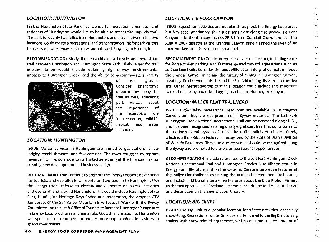
LOCATION: HUNTINGTON
ISSUE: Huntington State Park has wonderful recreation amenities, and residents of Huntington would like to be able to access the park via trail. The park is roughly two miles from Huntington, and a trail between the two
locations would create a recreational and transportation link for park visitors to access visitor services such as restaurants and shopping in Huntington.
RECOMMENDATION: Study the feasibility of a bicycle and pedestrian
trail between Huntington and Huntington State Park. Likely issues for trail implementation would include obtaining right-of-way, environmental
impacts to Huntington Creek, and the ability to accommodate a variety
LOCATION: HUNTINGTON
of user groups. Consider interpretive opportunities along the trail as well, educating park visitors about
the importance of the reservoir's role in recreation, wildlife habitat, and water resources.
ISSUE: Visitor services in Huntington are limited to gas stations, a few lodging establishments, and few eateries. The town struggles to capture revenue from visitors due to its limited services, yet the financial risk for creating new development and business is high.
RECOMMENDATION: Continue to promote the Energy Loop as a destination for tourists, and establish local events to draw people to Huntington. Use the Energy Loop website to identify and elaborate on places, activities and events in and around Huntington. This could include Huntington State Park, Huntington Heritage Days Rodeo and celebration, the Arapeen ATV Jamboree, or the San Rafael Mountain Bike Festival. Work with the Byway Committee and the Utah Office of Tourism to increase Huntington's exposure in Energy Loop brochures and materials. Growth in visitation to Huntington will spur local entrepreneurs to create more opportunities for visitors to spend their dollars.
60 ENERGY LOOP CORRIDOR MANAGEMENT PLAN
----------------------------~-------- ---
LOCATION: TIE FORK CANYON
ISSUE: Equestrian activities are popular throughout the Energy Loop area, but few accommodations for equestrians exist along the Byway. Tie Fork Canyon is in the drainage across SR-31 from Crandall Canyon, where the
August 2007 disaster at the Crandall Canyon mine claimed the lives of six mine workers and three rescue personnel.
RECOMMENDATION: Create an equestrian area at Tie Fork, including space for horse trailer parking and features geared toward equestrians such as soft-surface trails. Consider the possibility of an interpretive feature about the Crandall Canyon mine and the history of mining in Huntington Canyon, creating a link between this site and the Scofield mining disaster interpretive site. Other interpretive topics at this location could include the important role of tie hacking and other logging practices in Huntington Canyon.
LOCATION: MILLER FLAT TRAILHEAD
ISSUE: High-quality recreational resources are available in Huntington Canyon, but they are not promoted in Byway materials. The Left Fork Huntington Creek National Recreational Trail can be accessed along SR-31, and has been recognized as a regionally-significant trail that contributes to the nation's overall system of trails. The trail parallels Huntington Creek, which is a Blue Ribbon Fishery as recognized by the State of Utah's Division of Wildlife Resources. These unique resources should be recognized along the Byway and promoted to visitors as recreational opportunities.
RECOMMENDATION: Include references to the Left Fork Huntington Creek National Recreational Trail and Huntington Creek's Blue Ribbon status in Energy Loop literature and on the website. Create interpretive features at the Miller Flat trailhead explaining the National Recreational Trail status, and include additional interpretive features about the Blue Ribbon Fishery as the trail approaches Cleveland Reservoir. Include the Miller Flat trailhead as a destination on the Energy Loop itinerary.
LOCATION: BIG DRIFT
ISSUE: The Big Drift is a popular location for winter activities, especially snowkiting. Recreational wintertime users often travel to the Big Drift towing trailers with snow-related equipment, which consume a large amount of

space in the parking areas. In order to efficiently accommodate as many vehicles as possible, parking area users need guidance on proper parking technique to maximize the space available.
RECOMMENDATION: Install parking diagrams which instruct drivers in proper parking technique and etiquette. Similar parking diagrams have already been installed at the Skyline Drive trailhead near the junction of SR-31 and SR-264, and have been effective at improving parking circulation.
LOCATION: SKYLINE DRIVE TURNOFF
ISSUE: Skyline Drive is a Scenic Backway, administered by the MantiLa Sal National Forest. From Skyline Drive, travelers can see the Oquirrh mountains, Mount Nebo, and the Roan Plateau, while traversing 10,000-foot-high ridges. Scenic Backway signage would add recognition for Skyline
Drive and encourage side trips from the Energy Loop. However, Backway travelers would need to be aware that Skyline Drive may be impassable in inclement weather.
RECOMMENDATION: Install Skyline Drive Scenic Backway signage at the turnoff to Skyline Drive. The signage should indicate that roads may be closed or impassable depending on weather and seasonal conditions. Include signs or panels for the Great Western Trail, which is also Skyline Drive in this area. Also include a map showing the entire Skyline Drive alignment, and indicating directions from Skyline Drive to communities in the area such as Joe's Valley, Ferron, Mayfield, Sterling, Manti, Ephraim, Spring City, and Mount Pleasant.
LOCATION: HUNTINGTON AND ECCLES CANYON
ISSUE: A wide range of issues makes planning for the Wasatch Plateau between Huntington and Eccles Canyon a very complex process. Private property interests, livestock grazing rights, forest management, and a
variety of recreational user groups (snowboarders, backcountry skiers, OHV users, equestrians, etc) all come into play and occasionally clash against one
another. In addition, OHV and ATV users occasionally stray from designated
trails in order to access more desirable terrain such as ridgelines.
RECOMMENDATION: Create interpretive displays at the Skyline Drive
trailhead educating various user groups on how to treat one another respectfully. The displays should address right-of-way issues between equestrians/cyclists/hikers/OHV users/wintertime users; proper behavior around livestock; information on historic trails and their role in the grazing
and timber industries in the Manti-La Sal; and trail user etiquette when crossing private property. In addition, improved trail markers may be needed, as well as increased enforcement of trespassing laws.
LOCATION: FAIRVIEW
ISSUE: Visitor services in Fairview are limited, particularly when attempting to attract overnight visitors. Many of the byway travelers that come for wintertime activities are traveling from the Salt Lake City area, which is a relatively short driving distance away. Since food and lodging establishments are fe~ there is little incentive for visitors to stay overnight and spend money in Fairview.
RECOMMENDATION: Continue to promote the Energy Loop as a destination for tourists, and establish local events to draw people to Fairview. Use the Energy Loop website to identify and elaborate on places, activities and events in and around Fairview. Update the links on the Energy Loop website to the correct locations, and update the Fairview and Sanpete County webpages accordingly. This could include Fairview Lace Days, Fairview Follies, the Skyline 10K Run, or the Snowmobile Shootout. Work with the Byway Committee and the Utah Office of Tourism to increase Fairview's exposure in Energy Loop brochures and materials. Capitalize on successes already experienced in Fairview through the winter recreation industry to establish more events and a Fairview fan base. Growth in visitation to Fairview will spur local entrepreneurs to create more opportunities for visitors to spend their dollars.
LOCATION: FAIRVIEW
ISSUE:Fairviewhasalreadyexperiencedsomesuccessesduetoitsassociation with the snowkiting areas on the Wasatch Plateau and related businesses
in Fairview that cater to snowkiters, snowmobilers, and other wintertime recreationists. Fairview has an established wintertime festival with the Snowmobile Shootout, and residents in Fairview have expressed interest in creating a yurt network for snowmobile enthusiasts. Such a network would
ENERGY LOOP CORRIDOR MANAGEMENT PLAN 61
------- -----------------------

encourage snowmobilers to gather resources in town for supplies and food, and direct them to established snowmobile trails or routes that connect to a series of yurts for overnight stays.
RECOMMENDATION: Study the feasibility of creating a yurt trail network, including funding options and strategies for marketing it to a target audience.
· Work with private property owners to evaluate trail alignment options, and
coordinate with Manti-La Sal National Forest representatives to determine suitable slopes and connections to regional trails. Include consideration of incentives to private property owners who provide access to trail users.
LOCATION: SR-31 SNOWBOARDER DROPOFF/PICKUP AREA
ISSUE: Informal snowboard and ski shuttles are extremely popular along some portions of the Energy Loop. Riders and skiers start near the top of the Wasatch Plateau, and are picked up in the upper portion of Fairview Canyon. This results in an unofficial pick-up area near Wasatch Academy's property in the upper canyon, and creates a traffic hazard. Byway travelers are not expecting vehicles to be stopped along the roadway, and sometimes shuttle traffic is so heavy that the roadway is completely blocked. Furthermore, this is a location with frequently icy conditions and narrow roadways, which makes a difficult situation more dangerous. Representatives from the Utah Department of Transportation are already investigating the possibility of creating a pullout area to accommodate shuttle traffic. There are other problems associated with the ski and snowboard activity as well, primarily involving trespassing on private property owned by the Wasatch Academy and other individuals. However, promoting the Energy Loop as a winter sports paradise has proven effective in the snowkiting industry, and providing access and amenities for skiers and snowboarders could be a positive step for increasing tourism in the area.
RECOMMENDATION: Continue to evaluate the potential for a shuttle pullout and turnaround area. Likely issues will include coordination with private property owners, sight distance for oncoming traffic in both directions, the abilityto accommodate more roadway in a narrow canyon, and environmental impacts to slope stability and waterways. Establish a working
relationship with private property owners in the area to find a solution that preserves private property rights while accommodating recreationists.
6.1 ENERGY LOOP CORRIDOR MANAGEMENT PLAN
LOCATION: FAIRVIEW CANYON, SR-31
ISSUE: The extreme terrain of this canyon presents some safety hazards to
travelers. Eastbound traffic on SR-31 parallels steep dropoffs into the canyon bottom; near mid-canyon, westbound traffic must hug rock walls along the north side of the road, from which rocks frequently escape and fall into the roadway. While crash rates and crash severity are still better than would be
expected along this roadway, some improvements could still be made.
RECOMMENDATION: Consider guardrail near the portions of roadway with steep dropoffs, and consider rock netting or other preventive measures to keep rocks off the roadway. Consider variable-message speed feedback signs similar to those used along US-6 in Spanish Fork Canyon.
LOCATION: ENERGY LOOP
ISSUE: There are several untapped opportunities for side trips or themed tours along the Energy Loop, which may potentially bring more visitors to the Byway and its gateway communities. Promotional materials and websites featuring the Energy Loop make little mention of these side trip opportunities.
RECOMMENDATION: The following loop tours should be marketed and advertised in conjunction with the Energy Loop Scenic Byway:
Scenic Backways:
1 Skyline Drive Scenic Backway (accessible at the junction of SR-31 and SR-264)
2 Dinosaur Quarry/ Cedar Overlook Scenic Backway (accessible east of Huntington and near the Cleveland-Lloyd Dinosaur Quarry)
3 Wedge Overlook/ Buckhorn Draw Scenic Backway (accessible east of Castle Dale and into the San Rafael Swell)
4 Mayfield-Ferron Scenic Backway (accessible west of Ferron or off of US-89 near Gunnison)
5 Nine Mile Canyon Scenic Backway (accessible east of Price off of US-6)

6 Reservation Ridge Scenic Backway {accessible north of Helper on US-6, and loops back to Helper on US-191)
Scenic Byway Loops:
1 The Energy to Fuel the Nation Loop {travel the loop created by visiting Price, Helper, Colton, Scofield, the Skyline Mine, Huntington Canyon, the City of Huntington, and returning to Price)
2 The Heritage Loop {travel the loop created by visiting Fairview, Mt. Pleasant, Spring City, Ephraim, Manti, crossing over the Mayfield-Ferron Scenic Backway, up SR-10 through Ferron, Clawson, Castle Dale, Huntington, and continue on SR-31 in Huntington Canyon to return to Fairview)
Proposed Themed Sidetrips:
1 Dinosaurs & More: A Tour of This Region's Spectacular Paleontological Resources
2 Arts, Crafts, Antiques and Heritage Products of Central Utah Tour
3 Museum Tours
4 Historic Architecture Tours
5 In Search of Rock Art Tour
6 Tours of the San Rafael Swell
7 Rafting the Green River
8 Exploring Historic Trails: The Spanish Trail, the Outlaw Trail, the Walker Trail, and the Spirit Railroad
9 Exploring Our Pioneering Heritage: Pioneer Museums, Historic Dugouts, and Cabins
1 0 Ghost Town Tours: Stepping Back to an Earlier Time
PROPOSED GHOST TOWN LOOP TOUR
RECENT DEVELOPMENTS IN SCENIC BYWAY LEGISLATION In 2009, the regulations affecting State Scenic Byways, National Scenic
Byways, and All American Roads in the State of Utah changed considerably. The 2009 legislative session saw the reorganization of the Utah State Scenic Byway Committee, which now includes representation from many federal and state agencies as well as elected officials. The Committee is responsible for designating highways as state scenic byways, and also for ensuring that highways designated for National Scenic Byway status possess at least one of the six intrinsic qualities for scenic byways {scenic, natural, historic, cultural,
archeological, or recreational). The 2009 changes also require that any action seeking scenic byway status for a highway in Utah must be sanctioned in writing by the legislative body of the counties, cities, and towns through which the proposed byway passes. If any of these bodies do not give approval of the scenic byway designation in writing, the section of roadway within the municipal boundaries may not be designated as a byway. Furthermore,
a person or entity may request segmentation of a portion of the byway, if consent of the landowners along that portion of the byway is provided. The
legislative body governing the area of proposed segmentation may grant the request if the property in question is deemed to be ~~non-scenic." At this writing, there is little guidance available to determine what makes an individual property "scenic" or ~~non-scenic", but "non-scenic" is generally being interpreted to mean that the intrinsic value(s) for which a given Byway
ENERGY LOOP CORRIDOR .MANAGEMENT PLAN 6 3
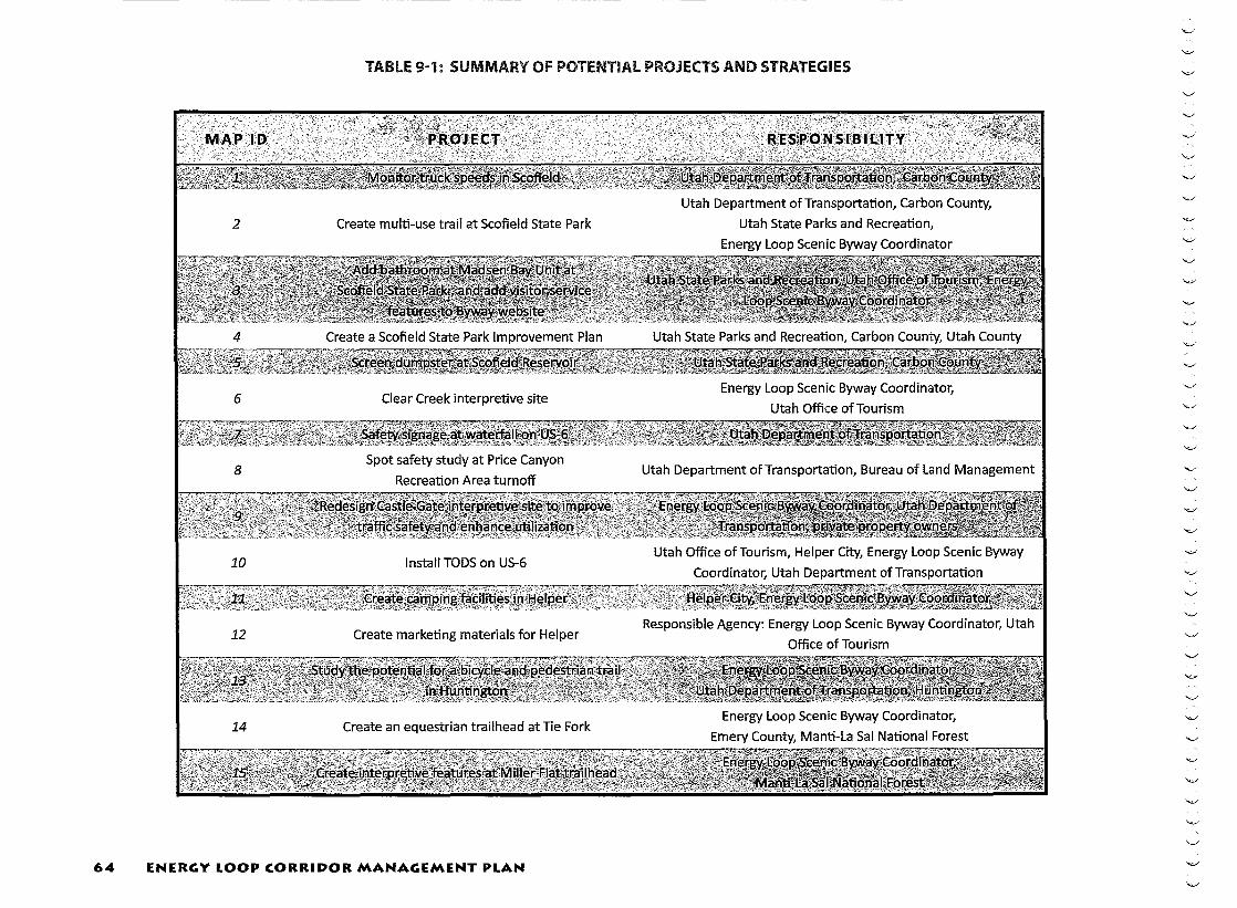
TABLE 9-1: SUMMARY OF POTENTIAL PROJECTS AND STRATEGIES
64 ENERGY LOOP CORRIDOR MANAGEMENT PLAN

ENERGY LOOP CORRIDOR .MANAGEMENT PLAN 65

8 Potential Project Sites
- Energy Loop Scenic Byway
- Proposed Energy Loop Scenic Byway Extension
Other Major Roads
Rivers
fP FEHR & PEERS TRANSPORTATION CONSULTANTS
\;,.:/'
FIGURE 7 Potential Project Sites
-------------------------------
c
,-\
c c
was designated do not reside on that property. The laws enacted in 2009 state that administrative rules will be required to address this and other issues. Administrative Rule R926-7 was rescinded and replaced by Rules R926-13 and R926-14 in July 2010, in response to this requirement. The statewide legislation affecting scenic byways may be found in Section 72-4-303 of the Utah State Code. In addition, the 2009 legislation directed that any nomination for National Scenic Byway status must be approved by the legislature, a requirement that was later modified in 2010.
Further changes occurred regarding the Scenic Byway program in the 2010 legislative session. Scenic Byway amendments were proposed which required legislative approval of a Corridor Management Plan before nomination for a National Scenic Byway or All-American Road, rather than requiring approval of the nomination. The amendments further clarified that a Corridor Management Plan is a written document that specifies the actions and procedures that will be taken to maintain intrins!c qualities along the byway; and that it must be adopted by each municipality or county affected by the plan. At this writing, the amendments were approved by the House and Senate during the 2010 legislative session, and are awaiting signature by the governor.
OUTDOOR ADVERTISING REGULATIONS
Scenic Byways are frequently of interest to the outdoor advertising industry, and representatives from the industry should be invited to be part of the planning process. Representatives from several of the outdoor advertising agencies in the central Utah area were invited to participate in this CMP update, and they provided valuable feedback during the process. While most of the Energy Loop is already a National Scenic Byway, the extensions proposed in Price Canyon and in Huntington have different controls in place
than the existing Scenic Byway. Portions of the local codes refer to outdoor advertising features, as does UDOTpolicy. The relevant codes and regulations are summarized below.
CARBON COUNTY
The Carbon County Development Code states that non-accessory signs within 660' from a state or federal highway right-of-way must be approved by UDOT. The Carbon County Development Code allows advertising signs
of various types, but only in zoning districts where the signs are expressly identified as permitted uses. The Carbon County zoning districts relevant to this CMP include Watershed (WS) and Mining and Grazing (M&G). However, neither of these zones allows non-accessory {billboard) signs as a permitted or conditional use. This indicates that billboards are currently not allowed along the proposed Price Canyon extension of the Energy Loop, and a state or national Scenic Byway designation will not impact current billboard practice along this section.
EMERY COUNTY
Emery County's zoning ordinance makes little mention of billboards. They are not expressly identified as a permitted use in the relevant Emery County zoning districts along the Byway (A-1, M&G1, M-1, or 1). The zoning ordinance does state that billboards promoting Emery County can be erected with approval of the County Commission. In incorporated areas, these promotional boards must have approval from both the local Planning Commission and the County Commission.
SANPETE COUNTY
The Sanpete County zoning ordinance governs sign regulations for lands in the unincorporated County. The ordinance allows commercial signs as a
conditional use within or adjacent to the Business/Commercial (BC) zone. They are not allowed in any other zone. There are no areas of BC zone along the portion of the Energy Loop in Sanpete County, and therefore signs and billboards are not allowed along the Energy Loop within the County's jurisdiction.
UDOT
UDOT controls the placement of billboards on many state highways, including scenic byways. Currently UDOT prohibits billboards along the US-6 portion ofthe proposed Price Canyon extension of the Energy Loop. This prohibition
would continue if scenic byway status is approved. UDOT is in the process of creating a tourist-oriented direction sign (TODS) program for scenic byways in Utah, and the program is expected to be ready for use in late 2010. The TODS program can be used to indicate the locations of local businesses for travelers along the Byway.
ENERGY LOOP CORRIDOR MANAGEMENT PLAN 67

10: MULTILINGUAL ACCOMMODATIONS ~==========================================================
Multilingual accommodations were addressed in detail in the 1999 CMP, and so are not re-evaluated in this CMP update. Document information for the 1999 CMP can be found in the References section of this CMP.

11: MONITORING AND EVALUATION
MONITORING AND EVALUATION The Huntington/Eccles Canyons Scenic Byways have been in existence since 1990, and Price Canyon and SR-10 extensions are proposed as part of this 2010 CMP update. The Energy Loop Scenic Byway Committee is made up of communities and representatives from local, state and federal agencies and organizations that are invested in the success of the Byway and their contributions to meeting local goals. Some of the individuals on the committee have been active participants since the inception of the Energy Loop. This extensive experience will be helpful in the overall evaluation and monitoring of Byway initiatives implemented on behalf of the Energy Loop.
The Energy Loop Scenic Byway Committee will continue to work closely with local preservation and special interest groups to coliaborate on the sensitive identification, interpretation, and development of cultural
resources for the travelling public's learning pleasure. In particular, it will work to advocate for and support historic preservation efforts in Scofield that help maintain the historic character of that unique community.
Federal and state agencies (in particular, the Manti-La Sal National Forest) will continue to identify archaeological and historic sites within the corridor as part of on-going management of these resources. This includes identifying the potential effect of activities related to the management of the scenic byway itself. The Forest Service will involve the Energy Loop Scenic Byway Committee in decisions related to the National Register eligibility of these resources and their potential use as interpretive features for byway visitors.
The Energy Loop Scenic Byway Committee is committed to monitoring and evaluating how improvements, development, and increased marketing will impact the intrinsic qualities and resources of the Byway. The Byway Committee has actively implemented a program as part of its ongoing management efforts, and will continue to do so in the future. The components of this program are described below.
IMPACT ASSESSMENT Efforts will be made to work closely with the local, state and federal agencies, and private corporations and individuals that manage resources along the Byway to measure the impacts along the Energy Loop. This will include:
• Monitoring traffic changes, safety incidents, and usage;
• Conducting research to determine the economic impact of the Byway; and
• Surveying visitors to identify user profile, visitor satisfaction with attractions and services, and unmet needs.
ANNUAL BYWAY STATUS The Energy Loop Scenic Byway Committee will provide an annual assessment on the progress of the Corridor Management Plan implementation and
problems or issues that may be occurring along the Byway or throughout the corridor. This report will be in a written format and available to the public.
REGULAR MEETINGS There will be an annual meeting of members of the Byway Committee and interested public. At this meeting, an update will be given on the status of the Corridor Management Plan implementation, safety and preservation issues, local economic growth and expansion, and other issues important
to Byway management and growth. The public will be invited to discuss any issues or concerns. In addition, the Byway Committee will meet on a regular basis throughout the year to discuss issues, identify funding needs and opportunities, and coordinate on the implementation of the CMP.

~================================================= NATURAL RESOURCES ORGANIZATIONAL REVIEW Every five years the managers of key historic and natural resource attractions throughout the byway corridor will be asked to make a presentation as to the status of these properties. The key sites and management organizations
along the Byway that will be asked to participate include, but are not limited to:
• Manti La Sal National Forest
• Bureau of Land Management
• Scofield, Millsite, Huntington, and Palisade State Parks
• CEU Prehistoric Museum
• Western Mining and Railroad Museum
• Fairview Museum of History and Art
• Museum of the San Rafael
• Utah Division of Wildlife Resources
• Emery County Historical Society
• Carbon County Historical Society
• Sanpete County Heritage Council
• Castle Valley Archaeology Society
• Emery County Public Lands Council
• Regional user groups including snowmobile, mountain biking, ATV, fishing, horse groups
• Friends of the Manti
• Rock Art Society
Every five years, the tourism organizations along the Byway will be asked to address Byway marketing issues and the challenges and opportunities they face in marketing their tourism resources along the route. The key tourism organizations that will be invited to participate include, but are not limited to:
• Utah Travel Council
• Carbon County Travel Bureau
• Carbon County Economic Development
• Carbon County Chamber of Commerce
• Sanpete County Chamber of Commerce
• Sanpete County Tourism Council
• Sanpete County Economic Development Office
• Emery County Economic Development
• Emery County Travel Bureau
• Emery County Chamber of Commerce
• Helper Main Street Program
• Mt. Pleasant Main Street Program


11: REFERENCES ~=====================================================
1 United States. Department of Agriculture] Forest Service. Land and Resource Management Plan. Manti-La Sal National Forest. Price] Utah: 1986. http:/ /www.fs.fed.us/r4/ mantilasal/projects/forest_plan_1986/planindex.shtml
2 Huntington and Eccles Canyons Scenic Byway Committee. Huntington and Eccles Canyons Scenic Byways Corridor Management Plan. Price] Utah: 1999.


APPENDICES ~~==============================

UTAH COUNTY ("oonnumil~- o ... ·~Jopmottl ~-
Robin Hutcheson Fehr and Peers 2180 South 1300 East, Suite 220 Salt Lake City, UT 84106
~~~ Ann~trong il.'«llfantDI!'11"tar
March 23, 2010
RE: Energy Loop Scenic Byway Corridor Management Plan Update
Dear Ms. Hutcheson:
SJSantht!nit·~itJAt•c-. Sui!~ lt7
l'rm-~.ut~hlr46llt l'ltan~ 801·8~1-lt'4~ Fn 801-S$1-!1~411
I received your letter dated March 16, 2010 regarding the Energy Loop Scenic Byway Corridor Management Plan (CMP) update and appreciate vour involvement ofUtah County in the process. was glad to be able to attend the open liouse in November 2009.
I would characterize Utah County's position as one of"no concemsn rather than "no interest". Our land use policies would appear to be relatively compatible with this designation of US Route 6 and/or State Route 96. The zoning designation of this area, Mining and Grazing (M&G-1), does not allow billboards (non-accessory signs) and li!1lits signs to only advertise for legal uses located on the property. TI1e M&G-1 Zone allows very lnmted commercial uses and does not allow for convenience stores, gas stations, restaurants, etc. However, there is one present business (Hilltop Country Service) that is a legal non-conforming use in this area.
I ]'ave reviewed the matter with the Utah County Public Works Department and the only concern raised was the intersection ofUS-6 and Enm1a Park Road, the only county road that intersects with the highway in this area. It is our understanding this potential designation ofUS-6 will not affect the current use of this intersection.
1 hope this information help_s. We are comfortable in not actively participating in this process, but are "~llin?; to be involved If needed. Please contact me v,ith any questions or concerns on this matter at \801)851-8343.
SBely, O~Ji··/~ )\, 0 Bryce Arm\Jrong, Assistant Director
RESOLUTION NO. J Q I I - ;;;_
RESOLUTION ADOPTING THE ENERGY LOOP: HUNTINGTON/ECCLES CANYONS NATIONAL SCENIC BYWAY CORRIDOR MANAGEMENT PLAN UPDATE
WHEREAS, in accordance with the State of Utah Scenic Byways Program, SR 31 from Huntington to Fairview, SR96 from Colton to Clear Creek and SR264 from Clear Creek to the junction of SR264 and SR31 is currently designated as a Utah State Scenic Byway; and
WHEREAS, the Oty of Helper is a gateway community along the byway, as defined by the State of Utah Scenic Byways Program guidelines;
WHEREAS, a scenic byway Corridor Management Plan Update, as defined in Section 72-4-301 Utah Code Annotated, has been
prepared for the roadway currently designated as a State Scenic Byway; and
WHEREAS, said Corridor Management Plan Update has been prepared with the active participation by 'The Energy Loop' Scenic Byway committee, as well as a byway planning team assembled for that purpose which inc!uded representatives of all local municipalities along the byway corridor and carbon~ Emery and Sanpete officials, as well as individuals representing other agencies and interests, along with technical planning assistance provided by the staff of Fehr and Peers; and
WHEREAS, the section of the roadway covered in this Corridor Management Plan Update is as described above and includes two extensions; namely, a 14 mile extension from Colton to and including Helper Main Street and a two mile extension from
the intersection of SR31 and SR10 in Huntington to and including Huntington State Park; and
WHEREAS, the section of roadway covered by this Corridor Management Plan Update has been named The Energy Loop:
Huntington/Eccles Canyons National Scenic Byway; and
WHEREAS, The Energy Loop constitutes the basis of the corridor and connects the many archaeological, historic, natural, scenic, cultural and recreational intrinsic qualities found along and within the byway corridor that are of influence; and
WHEREAS, The Energy Loop Corridor Management Plan Update will reinforce the existing Energy Loop Scenic Byway Corridor Management Plan and
WHEREAS, pubic meeting opportunities were provided to explain The Energy Loop Byway Corridor Management Plan Update and obtain input from the genera! public; and,
WHEREAS, The Energy Loop Scenic Byway Corridor Management Plan Update includes strategies to preserve, protect and promote intrinsic qualities of the byway through actions that are not regulatory or otherwise mandated by the Plan; and
WHEREAS, successful implementation of The Energy Loop Scenic Byway Corridor Management Plan Update depends on cooperation, collaboration and support of the municipalities along the Byway and carbon, Emery and Sanpete Counties; and
WHEREAS, The Oty of Helper, Utah, supports The Energy Loop Scenic Byway Corridor Management Plan Update and gives it's
commitment to collaborate in the process necessary for its implementation.
NOW, THEREFORE, BE IT RESOLVED BY THE CITY COUNCIL OF HELPER, UTAH, that it does hereby adopt The Energy loop Scenic Byway Corridor Management Plan Update and affirms its intention to participate in future implementation strategies described
in the Plan.
This Resolution shall be effective on the date it is adopted. ._,.L
Adopted the CO day of January, 2011.
"'-.>'
0 0

RESOLUTION NO. I- d. 0 I I
RESOLUTION ADOPTlNG THE ENERGY LOOP: HUNTINGTON/ECClES CANYONS NATIONAl SCENIC BYWAY CORRIDOR MANAGEMENT PLAN UPDATE
WHEREAS, in accordance with the State of Utah Scenic Byways Program, SR 31 from Huntington to Fairview, SR96 from Colton to dear Creek and SR264 from Oear Creek to the ]unction of SR254 and SR31 is currently designated as a Utah State Scenic Byway; and
\VHEREAS, the Town of Scofield is a gateway community along the byway, as defined by the State of Utah Scenic Byways Program-guidelines;
WHEREAS. a scenic 'ayway Corridor Management ?Ian Update~ as defined in Section 72-4-301 Utah Code Annotated, has been prepared for the roadway currently designated as a State Scenic Byway; and
WHEREAS, said Corridor Management Plan Update has been prepared with the active participation by 'The Energy Loop' Scenic Byway committee, as. well as. a byway planning team assambied for that purpose which included representatives of all local munidpalftles along the byway corridor and carbon,. Emery and Sanpete offlclals, as well as lndMduals representing other agencies and interests, along with technical planning assiStance provided by the staff of Fehr and Peers; and
WHEREAS, the section of the roadway covered in this Corridor Management Plan Update is as described above and includes two extensions; namely, a 14 mile extens!on from Colton to and Including Helper Main Street and a two mlle extension from the Intersection of SR31 and SRlO in Huntington to and including Huntington State Park; and
WHEREAS, the section of roadway covered by this Corridor Management Plan Update has. been named The Energy Loop: HuntingtOn/Eccles canyons National Scenic Byway; and
WHEREAS, The Energy Loop constitutes the basis of the corridor and connects the many archaeological, historic. natural, scenic, cultural and recreational intrinsic qualities found along and within the byway corridor that are of influence; and
WHEREAS, The Energy Loop Corridor Management Plan Update will reinforce the existing Energy loop Scenic Byway Corridor Management Plan and
WHEREAS, pubic meeting opportunitleswere provided to explain The Energy Loop Byway Corridor Management Plan Update and obtain Input from the general public; and,
WHEREAS, The Energy Loop Scenic Byway Corridor Management Plan Update indudes strategies to preserve, protect and promote Intrinsic qualities of the byway through actions that are not regulatory or otherwise mandated by the Plan; and
WHEREAS, successful implementation of The Energy Loop Scenic Byway Corridor Management Plan Update depends on cooperation, collaboration and support of the munidpabtles along the Byway and carbon, Emery and Sanpete Counties; and
WHEREAS, The Town of Scofield, Utah. supports The Energy Loop Scenic Byway Corridor Management Pfan Update and gives it's commitment to collaborate in the process necessary for its implementation.
NOW, THEREFORE,. BE IT RESOLVED BY THE TOWN COUNOlOFSCOFIEW, UTAH, that it does hereby adopt The Energy loop Scenic Byway Corridor Management Plan Update and affirms Its Intention to participate in future Implementation strategies described in the Plan.
This Resolution shall be effective on the date it is adopted.
Adopted the l..f_day of January~ 2011.
Mayor Mike Erkkila
RESOlUTlON ADOPTING THE ENERGY LOOP: HUNTJNGTON/ECO.ES CANYONS NATIONAL SCENlC BYWAY CORRIDOR MANAGEMENT PLAN UPDATE
WHEREAS, in accordance with the State of Utah Scenic Byv.rays Program, SR 31 from Huntingtcm to Fairview, SR96 from Colton to Clear Creek and SR264 from Clear Creek to the junction of SR264 and SR31 ts c.;rrently designated as a Utah State Scenic
Byway; and
WHEREAS, the City of fairview is a gateway commur.ity along the byway, as defined by the State of Utah Scenic Byways Program guideiines;
WHEREAS, a scenic bY\-vay Corridor Management Plan Update, as defined in section 72-4-301 Utah Code Annotated, has been prepared for the roadway currently designated as a State Scenic Byway; and
WHEREAS, said Corridor Management Plan Update has been prepared with the active participation by 'The Energy Loop' Scenic Byway committee, as wel! as a byway planning team assembled for that purpose which included representatives of all local municipalities along the byway corridor and Carbon, Emery and Sanpete officials, as wefl as individuals representing other agencies and interests, along with technical planning assistance provided by the staff of Fehr and Peers; and
WHEREAS, the section of the roadway covered in this Corridor Management Plan Update is as described above and includes two extensions; namely, a 14 mile extension from Colton to and including Helper Main Street and a two mile extension from the intersection ofSR31 and SR10 in Huntington to and including Huntington State Park; and
WHEREAS, the section of roadway covered by this Corridor Management Plan Update has been named The Energy Loop: Huntington/Eccles canyons National Scenic Byway; and
WHEREAS, The Energy loop co.nstltutes the basis of the corridor and connects the many archaeolcgical, historic, natural. scenic, cultural and retreational intrinsic qua-lities found along and within the byway corridor that are of influence; and
WHEREAS, The Energy Loop Corridor Management Plan Update will reinforce the existing Energy Loop Scenk" Byway COrridor Management P.lan and
WHEREAS, pubic meeting opportunities were provided to explain The Energy Loop Byway Corridor Management Plan Update and obtain input from the general public; and,
WHEREAS, The Energy Loop Scenic BywayCo~ridor Management Plan Update includes strategies to preseNe, protect and promote intrinsic c;ualities of the byway through actions that are not regulatory or otherwise mandated by the Plan; and
WHEREAS, s.u;:cessfu! implementation of The Energy Loop Scenic Byway Corridor Management Plan Update depends on cooperation, collaboration and support of the mur.icipa!rties along the Byway and Carbon, Emery and Sanpete Counties; and
WHEREAS, The City of Fairviev;, Utah., supports The Energy loop Scenic Byway Corridor Management Plan Update and gives it's commitment to collaborate in the process necessary for its implementation.
NOW~ THEREFORE, BE IT RESOLVED BY THE C!TY COUNCIL OF FAIRVIEW, UTAH, that it does hereby adopt The Energy Loop Scenlc Byway Corridor Management Plan Update and affirms its intention to participate in future implementation strategies
described in the: Plan.
This Resolution shall be effective on the date it is adopted.
Adopted the __li_day of January, 2011.
/', ,··-~--;- 1) ~ Ati:~e'}\f/)~
Crtyf\§f_or er-JanAnderson

HUNTiNGTON CITY RESOLUTION 2-2011
RESOLUTION ADOPTING THE ENERGY LOOP: HUNTINGTON/ECCLES CANYONS NATIONAL SCENIC BYWAY CORRIDOR MANAGEMENT PLAN UPDATE
WHEREAS, in accordance with the State of Utah Scenic Byways Program, SR 31 from Huntington to Fairview, SR96 from Colton to Clear Creek and SR264 from Clear Creek to the junction of SR264 and SR31 is currently designated as a Utah State Scenic Byway; and
WHEREAS, the City of Huntington is a gateway community along the byway, as defined by the State of Utah Scenic Byways Program guidelines; and
WHEREAS, a scenic byway Corridor Management Plan Update, a.' defined in Section 72-4-301 Utah Code Annotated, ha.• been prepared for the roadv.-ay currently designated as a State Scenic Byway; and
WHEREAS, said Corridor Management Plan Update has been prepared with the active pm1icipation by 'The Energy Loop' Scenic BY''"'Y committee, as well as a byway planning team assembled for that purpose which included representatives of all local municipalities along the byway corridor and Carbon, Emery and Sm1pete officials, as well as individuals representing otl>er agencies and interests, along with technical planning assistance provided by the staff of Fehr and Peers; and
WHEREAS, the section of the roadway covered in this Corridor Management Plan Update is as described above and includes two extensions; namely, a 14 mile extension from Colton to and including Helper Main Street and a two mile extension from the intersection ofSR31 and SRlO in Huntington to and including Huntington State Park; and
WI!EREAS, the section of roadway covered by this Corridor Management Plan Update has been named The Energy Loop: Huntington/Eccles Cm1yons National Scenic Byway; and
Vv'HEREAS, The Energy Loop constitutes the basis of the corridor and connects the many archaeological, historic, nattl!al, scenic, cultural and recreational intrinsic qualities found along and within the byway corridor that are of interest; and
WHEREAS, The Energy Loop Corridor Managen1ent Plan Update will reinforce the existing Energy Loop Scenic BJ"'"'Y Corridor Management Plan; and
WHEREAS, pubic meeting opportunities were provided to explain The Energy Loop Byway Corridor Management Pian Update and obtain input from the general public; and,
WHEREAS, T'nc Energy Loop Scenic Byway Corridor Management Plan Update includes strategies to preserve, protect and promote intrinsic qualities of the byway through actions that are not regulatory or otherwise mandated by the Plan; and
WHEREAS, successful implementation of The Energy Loop Scenic Byway Corridor Management Plan Update depends on cooperation, collaboration and support of the municipalities along the Byway and Carbon, Emery and Sanpete Counties; and
WHEREAS, "111e City of Huntington, Utah, supports The Enert.'Y Loop Scenic Byway Corridor Management Plan Update and gives its commitr .. cnt to collaborate in the process necessary for its implementation,
NOW, THEREFORE, BE !T RESOLVED BY THE CITY COUNCIL OF HUNTINGTON, UTAII, that it does hcr~b~ adopt The Energy Loop Scenic Byway Corridor Management Plan Update and affirms its intention to parllClpatc m future implementation strategies described in the Plan.
BElT FUR"DIER RESOLVED, this resolution shall become effective immediately upon adoption by the Huntington City Council and supersedes all previous agreements on this subject.
PASS ED AND APPROVED tl1is __ I 9 __ day of January
ATTEST:
.f7::7 L r/-h ~-d .. ~~"
·M~~o--J~. COUNCIL MEMBERS
Mark Justice
Travis Larsen
Jeff Cowley
Julie Jones
, 2011.
""-'

c
c c
------------------------------------------------------


PUBLIC INVOLVEMENT SUMMARY The Energy Loop Scenic Byway Corridor Management Plan Update team coordinated several efforts to engage members of the public during the
planning process for the update. This document summarizes those efforts and the feedback received from them.
PROJECT WEBSITE At the outset of the project, the team developed a website for the Corridor Management Plan update at www.energyloopscenicbyway.com. The website was a forum for the public to learn more about the update process, and had tabs with information on the Energy Loop Scenic Byway, the update process, the Byway Committee for the update, a photo gallery,
and links to Byway stakeholders and agencies.
PUBLIC OPEN HOUSES In November 2009, the project team hosted a series of public open houses
in gateway communities along the Energy Loop. The open houses were
held on the following dates:
=~ ... ~~!J •.X:t.ulC- ~· .... ~·~-., .... -~:~W.-T~!ll.or>:S-1 ........ ..,..., ~·!
.....,..t_ .. _,l""_-x-o :O.ol'io.:.O.J.-:l .... ~~
~·.:.!~...:.'·~...;..~.__. ···-~-~""""=-.)'
'"-"'~· ... ·-::a<li""-»: "'''"'"'~- ... ~- -""""~ ~;:;:~:.~e:.~--..:JO , ••• 11:1 .... , •• "'_ ~-m
··--.. ·----~- _.,.,.. .... ~- .. .,._ ,..._c,,..,.,._ ""3'r'"C ... rz•T=t~- •-•'-""'_.,.__, •. ........_ _._., ---~~· ·--· - .. -;~~-· ....
• Tuesday, November 17, 2009, atthe Huntington Old City Hall, from 5- 6:30 pm
• Tuesday, November 17th, 2009, at the Helper City Council Chambers, from 6:30-8 pm
• Wednesday, November 18th, 2009, at the Fairview City Offices, from 5:30- 7 pm
Public notification of the open
houses was conducted through several means. Property owners along the Byway corridors
received mailers notifying them of the open house; residents of Fairview received inserts (as shown) in their utility bills; the project website included information about the open house locations and times; and stakeholders along the Energy Loop received emails alerting them to the open houses. Table Pl-1 lists the attendees to each open house.
Participants at the open houses were able to view information about the Scenic Byway program, the Corridor Management Plan process, and specific issues along the Energy Loop Scenic Byway. Visual displays for the open
house included:
• An overview of the Scenic Byway program, including a map of the Energy Loop and the identified study area;
• The timeline of Scenic Byway events along the Energy Loop, including changes in traffic patterns and tourist visitation;
• Issues and opportunities along the Energy Loop; and
• Proposed extensions to the Energy Loop on SR-6 and SR-10.
The project team also provided table-length maps of each segment of the Energy Loop, where meeting participants could identify other issues and opportunities to address in the Corridor Management Plan. Input received on these maps was incorporated into the recommendations and strategies
included in the plan.
ELECTED OFFICIALS Local legislators play an important role in Corridor Management Plans in the State of Utah. As part of the project team's outreach efforts, the consultant project manager and the Energy Loop Scenic Byway Coordinator

TABLE Pl-1: SUMMARY OF OPEN HOUSE ATTENDEES
PI SUMMARY ENERGY LOOP CORRIDOR MANAGEMENT PLAN
"--"'
0 0

took plan materials to the Utah State Legislature in March 2010. They met with the three elected representatives for the Energy Loop area (Senator David Hinkins, Representative Christine Watkins, and Representative Patrick Painter) to brief them on the planning process and some of the proposed
recommendations and strategies.
In addition, the project team worked throughout the planning process to engage municipal elected officials from the gateway communities, with
varying degrees of participation. Elected officials were invited to planning workshops, Byway Committee meetings, and open houses, and were invited to comment on the draft document as well.
PLAN REVIEW The project team also provided opportunities for the public to review the draft Corridor Management Plan Update online. The draft document was posted to the website described above, and stakeholders (including members of the public who attended open houses, elected officials, agency representatives, and outdoor advertising agency representatives) were sent an email notifying them that the document was available for review.
Stakeholders were invited to review the document and provide comment, although no comments on the draft were received from the stakeholders.
ENERGY LOOP CORRIDOR MANAGEMENT PLAN PI SUMMARY

. ......._,r
·~·
...__,·
"'--"'
""""'
~-'/