Embed Size (px)
Citation preview
June2013
TheFloodwayEncroachmentStandard:MinimizingCumulativeAdverseImpacts
i
Acknowledgements
Alan R. Lulloff, P.E., CFM, Science Services Program Director - Association of State Floodplain Managers is the primary author of this report. DAS Engineering LLC conducted the analysis of the HEC-RAS hydraulic engineering models. Samuel Johnson developed the maps included in the report and provided editorial assistance.
The following members provided helpful comments on initial drafts of this publication: Larry Larson, Dave Carlton, Ed Thomas, Sivash Beik, Tim Trautman, and Dave Knipe.
Cover Photographs Top: Sept. 8, 2011. Rain associated with Tropical Storm Lee flooded a development that was allowed to encroach into the floodway of Lycoming Creek in Run, Pennsylvania. (AP Photo/Williamsport Sun-Gazette, Mark Nance)
Bottom Left: Nov. 6, 2006. A house swept away by flood waters being conveyed down the floodway of the Cowlitz River near Packwood, Washington in the aftermath of a Pineapple Express storm event. (The Seattle Times/Lewis County Sheriff's Office)
Bottom Right: Aug. 28, 2011. Emergency personnel search for anyone who may be occupying a building in the floodway of Ola Creek in Waitsfield, Vermont. Rain associated with Tropical Storm Irene caused floodwaters to rise and caused massive flooding across the region. (AP Photo/Sandy Macys)
ii
TableofContents
Acknowledgements .............................................................................................................. i
Introduction ......................................................................................................................... 1
Background ......................................................................................................................... 1
More restrictive State and local standards for mapping floodways .................................... 3
National Flood Insurance Act of 1968 ................................................................................ 4
NFIA promotes floodplain land use management .......................................................... 4
NFIA addresses cumulative impacts ............................................................................... 4
Base Flood Elevations not increased to reflect surcharge amount ................................. 4
SFHAs include wider floodways in States with higher standards .................................. 5
Impact Assessment.............................................................................................................. 6
Impact on the physical characteristics of the floodway .................................................. 6
Methodology ............................................................................................................... 6
Results ......................................................................................................................... 7
Impact on flood damages ................................................................................................ 9
Impact on existing and new development built at or above the BFE ......................... 9
Impact on existing development constructed below the BFE ................................... 10
Impact on floodplain natural resources ......................................................................... 11
Discussion ......................................................................................................................... 12
Conclusions ....................................................................................................................... 13
References ......................................................................................................................... 15
Appendix A - Mitigating the Impact ................................................................................. 16
1
Introduction
Floods are the leading cause of natural disaster losses in the United States, having costapproximately$50billion inpropertydamage inthe1990sandaccounting formorethantwo‐thirdsoffederallydeclarednaturaldisasters(NationalResearchCouncil,2009).Directaverageannualflooddamageshavejumpedfromapproximately$5.6billionperyearinthe1990stonearly$10billionperyearinthe2000s,withsomeyearsmuchmorethat(GAO,2007). One of themajor contributors to this trend is encroachments into the floodplain(Galloway2013). Smallencroachmentsintoafloodplaininandofthemselvesmayhaveanegligibleimpactonfloodelevations.However,thecombined,incrementaleffectsofhumanactivity,referredtoas cumulative impacts, can cause significant increases in flooding. The National FloodInsuranceProgramattemptstoaddressthecumulativeimpactsofencroachmentsintothefloodplain through the use of a regulatory floodway. Federal minimum standards allowfloodways to be developed based on the concept of allowing some encroachments butlimitingtheincreaseinfloodelevationscausedbytheseencroachmentstoonefoot.Thisreportreviewstheorigin,useandestablishmentofregulatoryfloodwaysandprovidesanassessmentoftheimpactofencroachmentsbaseduponallowingaonefootincreaseinfloodelevationsduringtheregulatoryflood1.Theassessmentevaluatedimpactson:
1. thephysicalcharacteristicsofthefloodway(floodwaywidth,watervelocityandareainundated),
2. damagestonewandexistingdevelopmentinthefloodplainand3. floodplainnaturalresources.
ThereportalsoincludesanappendixthathighlightsmeasuresStateandlocalgovernmentshaveincludedintheirfloodplainmanagementregulationstolessenthecumulativeimpactofencroachmentsintothefloodplain.BackgroundEveryone lives in awatershed, that is, the land area that collects and feedswater into awaterway. Within these watersheds are areas that become inundated following heavyrainstormsorsnowmelt.Theseareas,calledthefloodplain,holdtheexcesswaterandallowit to be slowly released into the river system, to seep into groundwater aquifers, and betakenupbyplants.Floodplainsalsoofferaplaceforsedimenttosettleoutoffloodwaters,therebykeepingitoutofwaterwaysandcreatingfertilefloodplainvalleys.
1 TheregulatoryfloodalsoknownasthebasefloodadoptedbytheNFIPistheone‐percentannualchanceflood.Thelandareacoveredbythefloodwatersofthebasefloodiscalledthebasefloodplain.OnNFIPmaps,thebasefloodplain is called the Special FloodHazardArea (SFHA). The SFHA is the areawhere theNFIP’s floodplainmanagementregulationsmustbeenforcedbythecommunityasaconditionofparticipationintheNFIPandiswherethemandatoryfloodinsurancepurchaserequirementapplies.
2
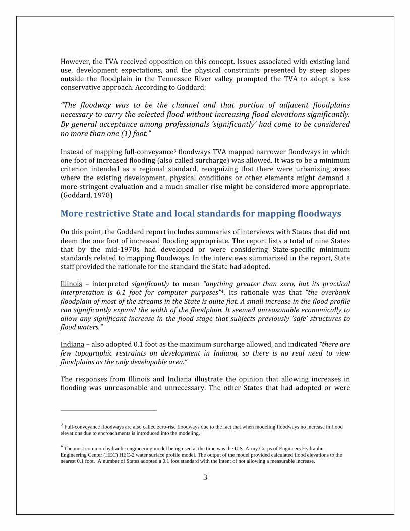
In the natural setting and in the absence of man, flooding occurs but there is no floodhazard. It isonlywith the introductionofhumanencroachment into the floodplain thatahazardisestablishedandtheproblemofflooddamagearises.Asmanmadedevelopmentisintroducedintothefloodplain,itcanbecomeanobstructioninadditiontobeingvulnerabletoflooddamage.Itmaysoencroachuponthewatercourseastoretarditscapacitytopassflood flows. The impacts on neighboring residents in a community and on adjacentcommunitiesareanincreaseinfloodcrestsandwiderareasbeingflooded.Historically disaster responsewas a State and local government responsibility. Followingseveralmajorflooddisastersintheearly1900stheU.S.CongressrecognizedthethreattolivesandlossesofpropertycausedbyunwisefloodplaindevelopmentandpassedtheFloodControl Act of 1936. The act directed federal efforts toward reduction of such losses byplacingemphasisoncontroloffloodwatersthroughtheuseofstructuralworks.However,majordisastersfromfloodingcontinued.Asaresult,therecamearealizationthatflood damage reduction programs needed to include not only levees, dams and otherprotective structures to correct existing problems, butalsomeasureswhichwouldmakepeoplemoreawareofthe risks.Theuseof floodplainmapsand regulations tosupplement flood control structures to reduce flooddamage potential and encourage wise use of thefloodplain was initiated in the 1950s by the TennesseeValleyAuthority(TVA)2.ThefirstfloodplainmapsintheU.S.weredevelopedbytheTVAin1953.(Goddard,1978)The floodplain regulations and associated maps wereintended to make people more aware of the risk andencouragesoundlanduseinthefloodplain. Whendeveloping floodplainmaps, theTennesseeValleyAuthority divided the floodplain into the floodway (theportion of the floodplain with flowing water) and theflood fringe (backwater areas). The TVA’s firstconsideration in designating floodways was fullconveyance floodways (see Figure 2). All of the areainundatedby the selected flood (e.g.one‐percent annualchance flood) was to be included, except those shallowareasandembaymentsintosmalldrainsorgullieswheretherewaspondingbutlittleifanyflow. Inotherwords, themapped floodwaywould comprise thosepartsof the floodplainthathavemovingfloodwaters.
2 The Tennessee Valley Authority is a federally owned corporation in the United States created by congressional charter in May 1933 to provide navigation, flood control, electricity generation, fertilizer manufacturing, and economic development in the Tennessee Valley.
Figure 2 – Shallow areas that do not effectively convey flood waters not included in the floodway. (Source: modified from MN DNR – Technical Report 6 1972)
3
However,theTVAreceivedoppositiononthisconcept.Issuesassociatedwithexistinglanduse, development expectations, and the physical constraints presented by steep slopesoutside the floodplain in the Tennessee River valley prompted the TVA to adopt a lessconservativeapproach.AccordingtoGoddard:“The floodway was to be the channel and that portion of adjacent floodplainsnecessarytocarrytheselectedfloodwithoutincreasingfloodelevationssignificantly.Bygeneralacceptanceamongprofessionals ‘significantly’hadcometobeconsiderednomorethanone(1)foot.”Insteadofmappingfull‐conveyance3floodwaysTVAmappednarrowerfloodwaysinwhichonefootofincreasedflooding(alsocalledsurcharge)wasallowed.Itwastobeaminimumcriterion intended as a regional standard, recognizing that there were urbanizing areaswhere the existing development, physical conditions or other elements might demand amore‐stringentevaluationandamuchsmallerrisemightbeconsideredmoreappropriate.(Goddard,1978)MorerestrictiveStateandlocalstandardsformappingfloodwaysOnthispoint,theGoddardreportincludessummariesofinterviewswithStatesthatdidnotdeemtheonefootof increasedfloodingappropriate.ThereportlistsatotalofnineStatesthat by the mid‐1970s had developed or were considering State‐specific minimumstandardsrelatedtomappingfloodways.Intheinterviewssummarizedinthereport,StatestaffprovidedtherationaleforthestandardtheStatehadadopted.Illinois – interpreted significantly to mean “anything greater than zero, but its practicalinterpretation is 0.1 foot for computer purposes”4. Its rationale was that “the overbankfloodplainofmostofthestreamsintheStateisquiteflat.Asmallincreaseinthefloodprofilecansignificantlyexpandthewidthofthefloodplain.Itseemedunreasonableeconomicallytoallowany significant increase in the flood stage that subjectspreviously ’safe’ structures tofloodwaters.”Indiana–alsoadopted0.1footasthemaximumsurchargeallowed,andindicated“therearefew topographic restraints on development in Indiana, so there is no real need to viewfloodplainsastheonlydevelopablearea.”The responses from Illinois and Indiana illustrate the opinion that allowing increases infloodingwas unreasonable and unnecessary. The other States that had adopted or were
3 Full-conveyance floodways are also called zero-rise floodways due to the fact that when modeling floodways no increase in flood elevations due to encroachments is introduced into the modeling.
4 The most common hydraulic engineering model being used at the time was the U.S. Army Corps of Engineers Hydraulic
Engineering Center (HEC) HEC-2 water surface profile model. The output of the model provided calculated flood elevations to the nearest 0.1 foot. A number of States adopted a 0.1 foot standard with the intent of not allowing a measurable increase.
4
considering a more stringent criterion listed in the Goddard report were Wisconsin,Michigan,NewJersey,Montana,Minnesota,Montana,Maryland,MassachusettsandOhio.
NationalFloodInsuranceActof1968
NFIApromotesfloodplainlandusemanagementInanattempt to reduce flooddamages todevelopment inhigh risk floodareas,CongresspassedtheNationalFloodInsuranceAct(NFIA)in1968.TheActcreatedtheNationalFloodInsuranceProgram,presentlyadministeredbytheFederalEmergencyManagementAgency(FEMA). The Act had three main goals: “to better indemnify individuals for flood lossesthroughinsurance;toreducefutureflooddamagesthroughStateandcommunityfloodplainmanagement regulations; and to reduce federal expenditures for disaster assistance andflood control.” A key provision of the 1968 Act prohibits FEMA from providing floodinsurance in a community unless the community adopts the flood elevations and floodhazardmapsdevelopedbythefederalgovernmentandenforcesfloodplainregulationsthatmeetorexceedthosestatedintheAct.
NFIAaddressescumulativeimpactsTheNationalFloodInsuranceActalsoincludesaprovisionintendedtolimitthecumulativeimpactsofencroachments into the floodplain.CommunitiesareprovidedFlood InsuranceRateMaps(FIRMs)thatcanincludearegulatoryfloodway.Section59.1oftheNFIAdefinesthe regulatory floodwayas “the channelof a riverorotherwatercourseand theadjacentlandareasthatmustbereservedinordertodischargethebasefloodwithoutcumulativelyincreasing the water surface elevation more than a designated height.” The designatedheightisestablishedintheCodeofFederalRegulations(CFR)Title44,Part60,Section60.3(d)(2)asbeingnomorethanone(1)footatanypoint.
When floodways are not mapped, communities must require landowners submittingproposalstoanalyzetheimpactoftheirproposedencroachmentonconveyancetoensuretheone‐footsurchargecriterion isnotexceeded.Withamappedfloodwaythisanalysis isconductedaspartoftheFEMAFloodInsuranceStudy,thusnoadditionalanalysisregardinglossofconveyanceisneededwhendevelopmentinthefloodfringeisproposed.
BaseFloodElevationsnotincreasedtoreflectsurchargeamountTheprimarypurposeofFloodInsuranceRateMaps(FIRMs)istoratethefloodinsurancepremiums for existing development at risk. FIRMs also identify where communities canallownewdevelopmentnotyetconstructed.FEMA’spositionisthatthemapsmustreflectconditions existing at the time the studywas conducted, not projected future conditionsthatcouldbepredicted.Consequently,basefloodelevations(BFEs)reflectedontheFIRMSdo not reflect the impact of encroachments within the floodway fringe. This is due toconcernsthatitwouldbeinappropriatetorequireownersofexistingdevelopmenttopayflood insurance premiums associatedwith a future risk thatmay nevermaterialize. TheBFEsthatareestablishedreflectexistingdevelopmentconditionswithintheSpecialFloodHazard Area, not the flood elevations that will result when the new development in theSFHAoccursandthefloodfringeisfilled.
5
ThusFIRMsaredual‐purposemaps,usedbothfor:
1. establishingfloodinsuranceratesforexistingdevelopmentatrisk,and2. guidingnewdevelopmentsothatitisreasonablysafefromflooding.
FEMAdoesnotgenerateaseparatemap for insuranceandone formanaging future floodrisk.
SFHAsincludewiderfloodwaysinStateswithhigherstandardsTheFEMAone‐footrisefloodwayisaminimalstandard,andcanbeexceededbyStatesorcommunitieswithstrongerstandards,i.e.,lowerthresholds.Section60.1(d)oftheNFIPregulationsstatesthatany“regulationsadoptedbyaStateoracommunitywhicharemore restrictive . . .are encouragedand shall takeprecedence (overnationalminimumstandards).”Thereare eightStates thathaveadoptedmore stringent standardsby legallyenforceablestatutes or regulations. For these States FEMA computes the regulatory floodways usingthosestandards.FouroftheeightStateshaveestablishedthresholdsintendedtorepresenta “measurable amount” while the remaining four are compromise positions. The eightStateswiththeirassociatedlowerthresholdare:
Wisconsin‐ 0.01foot Illinois‐ 0.1foot Indiana‐ 0.1foot Michigan‐ 0.1foot NewJersey‐ 0.2foot Colorado‐ 0.5foot Minnesota‐ 0.5foot Montana‐ 0.5foot
Communities are treated differently than States because it is more likely that a new community administration could change the more restrictive floodway adopted by a previous administration (FIA Policy Notice 79-3). Recently, FEMA has shown greater flexibility in terms of actually publishing more restrictive floodways for communities that are Cooperating Technical Partners (CTP)5. Such communities “now have considerable latitude on how their floodways are designated and could map zero-rise floodways.” (FEMA Call for Issues, June 2000, page II-3-6.) (FEMA, 2004)
5 In 1999, FEMA initiated this program to enable capable communities to receive mapping funding and produce flood elevations and mapping that is incorporated into FEMA’s Flood Insurance Rate Maps.
6
ImpactAssessmentTheassessmentpresentedinthisreportfocusesontheimpactsofestablishingregulatoryfloodwaysbasedontheone‐footsurchargecriterion.Theassessmentevaluatedimpacton:1) the physical characteristics of the floodway (floodwaywidth, water velocity and areainundated), 2) damages to development in the floodplain and 3) floodplain naturalresources.
Impactonthephysicalcharacteristicsofthefloodway
Methodology
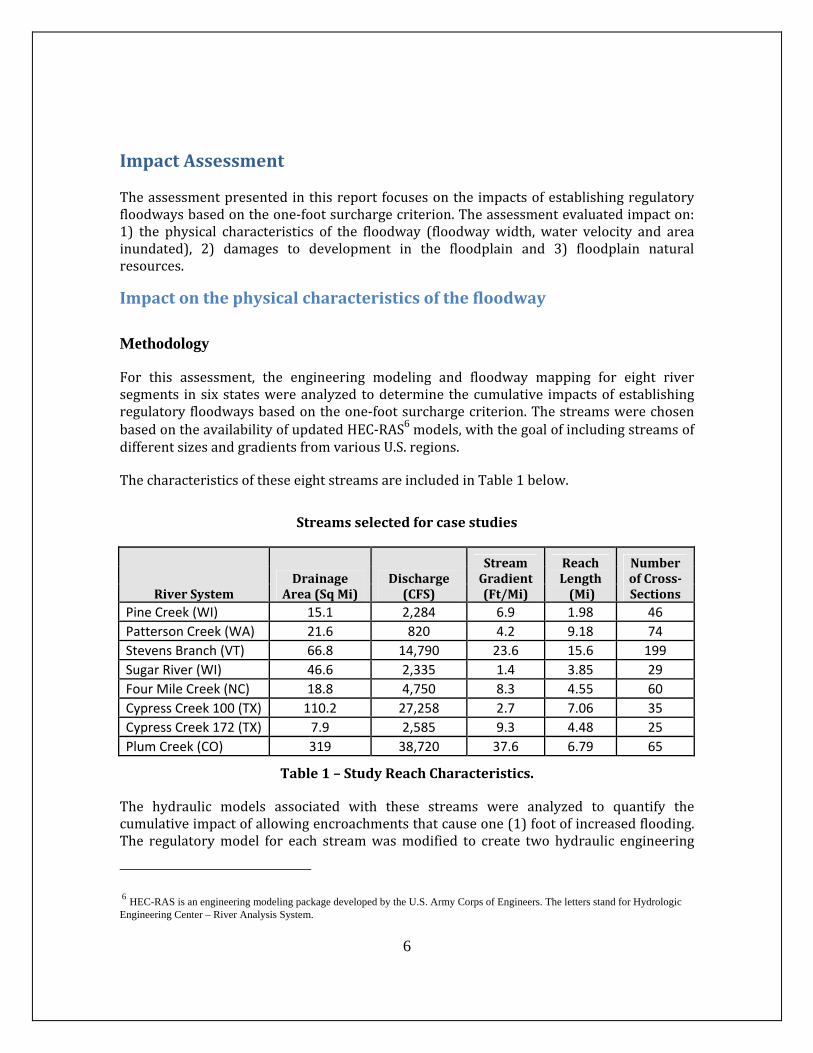
For this assessment, the engineering modeling and floodway mapping for eight riversegments insixstateswereanalyzed todetermine thecumulative impactsofestablishingregulatoryfloodwaysbasedontheone‐footsurchargecriterion.ThestreamswerechosenbasedontheavailabilityofupdatedHEC‐RAS6models,withthegoalofincludingstreamsofdifferentsizesandgradientsfromvariousU.S.regions.
ThecharacteristicsoftheseeightstreamsareincludedinTable1below.
Streamsselectedforcasestudies
RiverSystemDrainage
Area(SqMi)Discharge(CFS)
StreamGradient(Ft/Mi)
ReachLength(Mi)
NumberofCross‐Sections
Pine Creek (WI) 15.1 2,284 6.9 1.98 46
Patterson Creek (WA) 21.6 820 4.2 9.18 74
Stevens Branch (VT) 66.8 14,790 23.6 15.6 199
Sugar River (WI) 46.6 2,335 1.4 3.85 29
Four Mile Creek (NC) 18.8 4,750 8.3 4.55 60
Cypress Creek 100 (TX) 110.2 27,258 2.7 7.06 35
Cypress Creek 172 (TX) 7.9 2,585 9.3 4.48 25
Plum Creek (CO) 319 38,720 37.6 6.79 65
Table1–StudyReachCharacteristics.
The hydraulic models associated with these streams were analyzed to quantify thecumulativeimpactofallowingencroachmentsthatcauseone(1)footofincreasedflooding.The regulatorymodel for each streamwasmodified to create two hydraulic engineering
6 HEC-RAS is an engineering modeling package developed by the U.S. Army Corps of Engineers. The letters stand for Hydrologic Engineering Center – River Analysis System.
7
modelsforeachstudyarea.Onemodelreflectsafull‐conveyancefloodway.Theothermodelhasencroachmentstationsinsertedthatreducethewidthofthefloodwaybasedupontheone‐footsurchargethreshold.
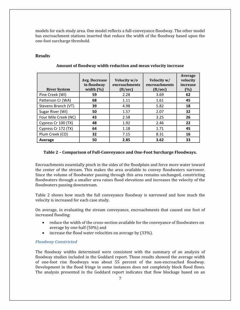
Results
Amountoffloodwaywidthreductionandmeanvelocityincrease
RiverSystem
Avg.Decreaseinfloodwaywidth(%)
Velocityw/oencroachments
(ft/sec)
Velocityw/encroachments
(ft/sec)
Averagevelocityincrease(%)
Pine Creek (WI) 59 2.28 3.69 62
Patterson Cr (WA) 68 1.11 1.61 45
Stevens Branch (VT) 39 4.98 5.82 18
Sugar River (WI) 50 1.57 2.07 32
Four Mile Creek (NC) 43 2.58 3.25 26
Cypress Cr 100 (TX) 48 1.92 2.46 22
Cypress Cr 172 (TX) 64 1.18 1.71 45
Plum Creek (CO) 32 7.15 8.31 16
Average 50 2.85 3.62 33
Table2–ComparisonofFull‐ConveyanceandOne‐FootSurchargeFloodways.
Encroachmentsessentiallypinchinthesidesofthefloodplainandforcemorewatertowardthe center of the stream. Thismakes the area available to convey floodwaters narrower.Sincethevolumeoffloodwaterpassingthroughthisarearemainsunchanged,constrictingfloodwatersthroughasmallerarearaisesfloodelevationsandincreasesthevelocityofthefloodwaterspassingdownstream.Table 2 shows howmuch the full conveyance floodway is narrowed and howmuch thevelocityisincreasedforeachcasestudy.
On average, in evaluating the stream conveyance, encroachments that caused one foot ofincreasedflooding:
reducethewidthofthecross‐sectionavailablefortheconveyanceoffloodwatersonaveragebyone‐half(50%)and
increasethefloodwatervelocitiesonaverageby(33%).
FloodwayConstrictedThe floodway widths determined were consistent with the summary of an analysis offloodwaystudiesincludedintheGoddardreport.Thoseresultsshowedtheaveragewidthof one‐foot rise floodways was about 55 percent of the non‐encroached floodway.Development in the flood fringe insome instancesdoesnot completelyblock flood flows.The analysis presented in the Goddard report indicates that flow blockage based on an
8
evaluation by experienced engineers varied from zero to 100 percent and averaged 25percent.Thereportnotesthattheanalysisincludesareasawayfromurbanareasandthattheaverageblockagethroughdenserurbanareaswillbehigher.Flood debris can increase the amount of flow blockage and damage adjacent properties.SomeStates(e.g.Wisconsin)requiredevelopmentinthefloodplaintobeconstructedonfilltherebycreatingacompleteobstruction to flood flows.Finally, floodwaysdeterminehowfarleveescanencroachintothefloodplainandwithleveesflowblockageis100percent.
VelocityIncreasedIncreasingtheflowvelocitycanbeproblematicinthatitincreasesturbulenceandthereforeincreases thestream'sability toerode.Aswatervelocity increasessodoes thesizeof thelargest pieceof sediment that floodwaters can carry.By increasing the velocity ofwatermovinginthechannel,theflowingwatercanscourthestreambedanddeepenthechannel.Thismeansthebanksarehigherandoftenmoreunstableresultinginincreasedstreambankerosionandmoresedimententeringthestream.Increasedsedimentationmakesitdifficultforsomefishtofeedandspawn,andtheincreasedvelocityofthestreamdrivesoutfishthatcannot tolerate fast‐movingwater (NMFS, 2008). These erosivewaters cause streams tomeander laterally, and fill or degrade vertically as they adjust to their water levels,sediments,andslope.Streamchannelsmaychangesuddenlyandcatastrophically.
AreaInundatedIncreasedAs the floodway is constricted and flood elevations rise, the area inundated by the sameflood event increases. For two of the streams analyzed topographic data was availablewhichallowedthegenerationoftwosetsoffloodinundationmaps.ThepercentofincreaseintheareainundatedisshowninTable3below.
RiverSystem Increaseinareainundated(%)Pine Creek 6
Sugar River 14
Average 10
Table3‐Comparisonofareainundatedfortwoscenarios Twostreamsdonotprovideenoughdatatoextrapolatethenumbersbuttheydohighlightthat with one‐foot surcharge floodways people that build structures just outside thefloodplainwill likely find those structures impacted as the allowable encroachments intothefloodplainoccur.
9
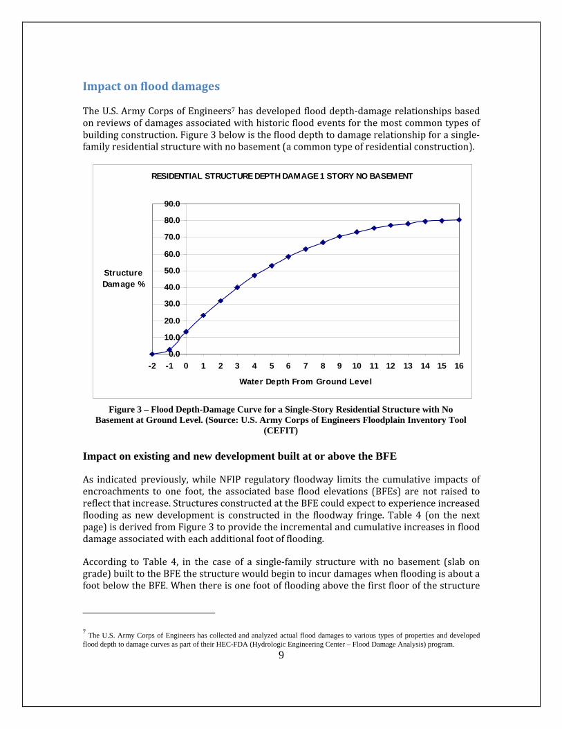
ImpactonflooddamagesTheU.S.ArmyCorpsofEngineers7hasdevelopedflooddepth‐damagerelationshipsbasedonreviewsofdamagesassociatedwithhistoricfloodeventsforthemostcommontypesofbuildingconstruction.Figure3belowistheflooddepthtodamagerelationshipforasingle‐familyresidentialstructurewithnobasement(acommontypeofresidentialconstruction).
Impact on existing and new development built at or above the BFE
As indicatedpreviously,whileNFIP regulatory floodway limits the cumulative impacts ofencroachments to one foot, the associated base flood elevations (BFEs) are not raised toreflectthatincrease.StructuresconstructedattheBFEcouldexpecttoexperienceincreasedflooding as newdevelopment is constructed in the floodway fringe. Table 4 (on the nextpage)isderivedfromFigure3toprovidetheincrementalandcumulativeincreasesinflooddamageassociatedwitheachadditionalfootofflooding.
According to Table 4, in the case of a single‐family structurewith no basement (slab ongrade)builttotheBFEthestructurewouldbegintoincurdamageswhenfloodingisaboutafootbelowtheBFE.Whenthereisonefootoffloodingabovethefirstfloorofthestructure
7 The U.S. Army Corps of Engineers has collected and analyzed actual flood damages to various types of properties and developed
flood depth to damage curves as part of their HEC-FDA (Hydrologic Engineering Center – Flood Damage Analysis) program.
RESIDENTIAL STRUCTURE DEPTH DAMAGE 1 STORY NO BASEMENT
0.0
10.0
20.0
30.0
40.0
50.0
60.0
70.0
80.0
90.0
-2 -1 0 1 2 3 4 5 6 7 8 9 10 11 12 13 14 15 16
Water Depth From Ground Level
Structure Damage %
Figure 3 – Flood Depth-Damage Curve for a Single-Story Residential Structure with No Basement at Ground Level. (Source: U.S. Army Corps of Engineers Floodplain Inventory Tool
(CEFIT)
10
theone footof additional floodingcausedbynarrowing the floodwaywould increase theflooddamagesincrementallyby~10%toover20%ofthetotalvalueofthestructure.
Table4‐Amtofdamagesperone‐footincrementofincreasedflooding
Impact on existing development constructed below the BFE
ExistingdevelopmentconstructedbelowtheBFEisbydefinitionmorevulnerabletoflooddamages.Anadditionalfootoffloodingwillincreasethedamagesincurred.Asanexampleforaonestorystructurewithnobasementwheretheamountoffloodingincreasesfrom4to5feetduringabasefloodeventthedamageswouldincreasefrom47%to53%.Thereisalsothepotentialforotherimpacts,whichinclude:
Limitationofaccesstofloodedproperties.Themaximumdepththroughwhichmostvehiclescansafelydriveistwofeet.Increasingflooddepthsfrom1.5feetto2.5feetcouldmeanahomeownermaynotbeabletosafelyreachhighgroundduringafloodevent. In addition, emergency vehicles could be prevented from responding to ahousefireormedicalemergency.
Possiblecompromiseofflood‐proofingmeasures.Homeownerscanattimespreventtheirstructuresfrombeinginundatedifthreatenedbyonetotwofeetoffloodingbyusingsandbags.Anadditionalfootormoreoffloodingcouldoverwhelmasandbageffortordryfloodproofing.
Flood Damages Associated with Flood Depth One Story Residence With No Basement
Depth
Incremental Increase in Flood Damages
Cumulative Increase in Flood Damages
-2 0.0% 0%-1 2.5% 2.5%0 10.9% 13.4%1 9.9% 23.3%2 8.8% 32.1%3 8.0% 40.1%4 7.0% 47.1%5 5.9% 53.2% 6 5.4% 58.6%7 4.8% 63.2%8 4.0% 67.2%9 3.3% 70.5%10 2.8% 73.2%
11
Impactonfloodplainnaturalresources
Riversandfloodplainsarecomplexecosystemscapableofsupportingmanylife‐formsandnaturalprocesses.Floodplainsmoderatewatersystemsbyabsorbingstreamoverflow,thuslessening flood events and providing storage for groundwater. Riparian vegetationcontributes nutrients, refuges, and dissolved oxygen, shades streams (lowering watertemperatures) and retains water. In their natural state, streams meander across afloodplain, forming intricatenetworksofwaterwayswithawidearrayofhabitats. (NMFS2008)
Despiterepresentinganaverageoflessthantwopercentofthesurfaceareaofwatersheds,floodplains provide 25 percent of all the services and benefits to terrestrial ecosystems.(Opperman,Lusteret.al.2010)
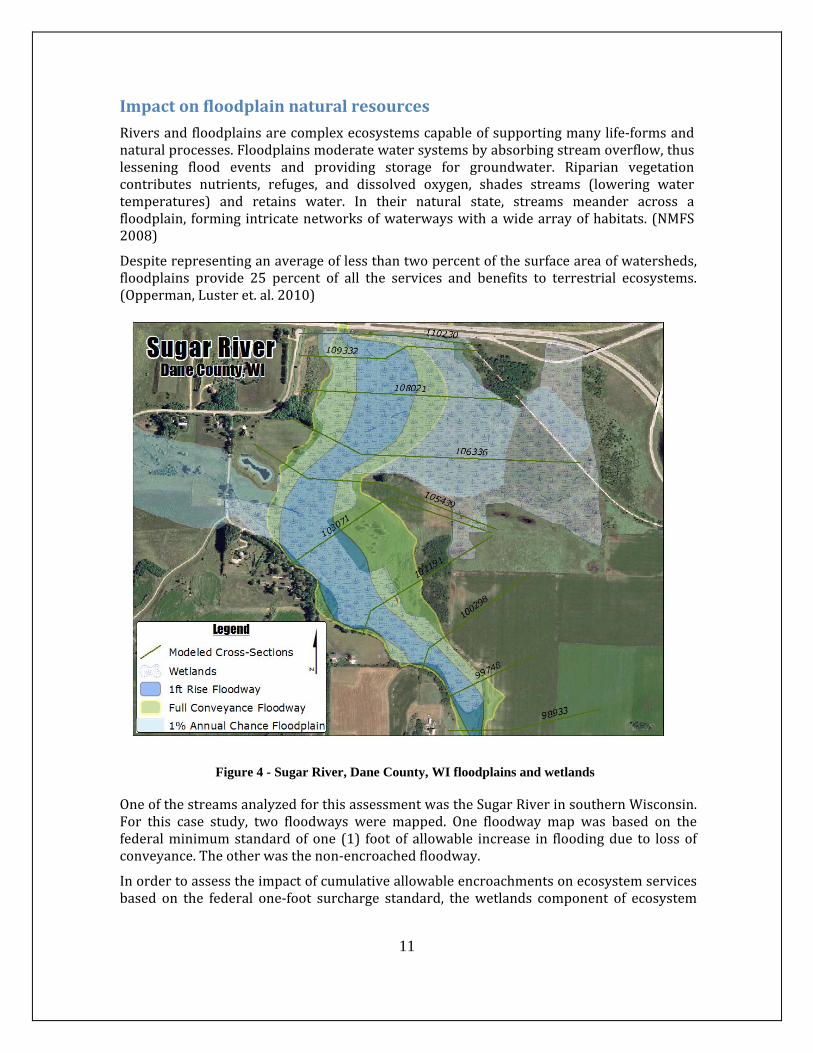
Figure 4 - Sugar River, Dane County, WI floodplains and wetlands
OneofthestreamsanalyzedforthisassessmentwastheSugarRiverinsouthernWisconsin.For this case study, two floodways were mapped. One floodway map was based on thefederalminimumstandardofone (1) foot of allowable increase in floodingdue to lossofconveyance.Theotherwasthenon‐encroachedfloodway.
Inordertoassesstheimpactofcumulativeallowableencroachmentsonecosystemservicesbased on the federal one‐foot surcharge standard, thewetlands component of ecosystem
12
serviceswasevaluatedforthisstreamsegment.WetlandsmappingwascomparedwiththetwodifferentfloodwaymapsdevelopedfortheSugarRivercasestudy(seeFigure4).
Results:ThetotalacresofwetlandslyingwithinthetwoSpecialFloodHazardAreasforthistwo‐milesegmentoftheSugarRiverwere:
Floodwaywithoutencroachments(95acres),and
One‐footsurchargefloodway(58acres).
Basedonthisanalysis,37acresofwetlands(18.5acres/streammile)wouldpotentiallybeimpactedifencroachmentswereallowedintothefull‐conveyancefloodwaytothelimitofaone‐foot flooding increasedueto lossofconveyance.Whenusingaone‐footsurchargeformapping the floodway, these 37 acres would be identified as flood fringe, wheredevelopment is generally allowed. Note: This does not necessarily apply to all streamsegmentsinawatershedorallwatershedsinthecountry.Wetlandsmoreoftenoccuralongstream segments in the lower portion of a watershed. In the arid west there are fewerwetlandsthanintheeastandMidwest.Intheseareas,othertypesofhabitat(e.g.floodplainforests)mayinsteadbetheresourceimpacted.DiscussionGoddard’s1978reportstatesthatthe floodway“wastobethechannelandthatportionofadjacentfloodplainsnecessarytocarrytheselectedfloodwithoutincreasingfloodelevationssignificantly”.Further,“Bygeneralacceptanceamongprofessionals [intheTennesseeValleyatthattime]‘significantly’hadcometobeconsiderednomorethanonefoot.”According to Goddard, the number one (1) did not suggest an accuracy or degree ofguidance that a fractionor fractionsof a footmight connote. It related,practically, to theengineeringjudgmentappliedinhydrologicandhydrauliccomputations.Unfortunately, what Goddard failed to recognize is the difference between absolute andrelativeaccuracy. It is indeedcorrect that floodplainstudieshaveadegreeofuncertainty,especially in early studies. However, what is being addressed when assessing proposedencroachments isnot theabsoluteaccuracyof thestudybut therelative increase in floodelevations that an encroachment into the floodplain will cause. This increase can bemeasuredwithagooddealofprecisionandisrelatedmoretothesurveyingmethodsusedtodeterminetheamountoftheencroachmentthantotheengineeringjudgmentassociatedwiththestudymethodology.Surveystandardsaresuchthatmeasurementstowithinafewcentimeters’(aboutoneinch)arecommon.Therationaleprovidedforselectingtheone‐footrisecriterionwasthatwasacompromisebetweenprohibitingencroachments into the floodplainwhilepermitting economical landuse and protecting against unreasonable invasion of property rights. However, a basicpropertylegalprinciplethatdatesbacktoancientJustinian(Roman)lawis:“Sicuteretuoutalienumnonlaedas”,or“souseyourownpropertythatyoudonotinjureothers”.Allowingnew development that increases flood elevations and velocities on existing developmentinjures others and therefore violates their property rights. (Kusler and Thomas, 2007;ThomasandMedlock,2008)
13
Asindicatedearlier,theStateofIllinoisinterpretedsignificantlytomean“anythinggreaterthan zero, but its practical interpretation is 0.1 foot for computer purposes”. The mostcommonhydraulic engineeringmodel beingused at the timewas theU.S.ArmyCorpsofEngineersHydraulicEngineeringCenterHEC‐2watersurfaceprofilemodel.Theoutputofthemodelprovidedcalculatedfloodelevationstothenearest tenthofafoot.AnumberofStates (Illinois, Indiana, Michigan and Wisconsin) adopted a 0.1 foot standard with theintentofnotallowingameasurableincrease.Inthe1980stheU.S.ArmyCorpsofEngineersmodified the engineeringmodelingprogram so that the output provided calculated floodelevationtothenearesthundredthofafoot(0.01foot).Consequently,Wisconsinmodifieditsstandardtoallowlessthan0.01foottomaintainitsrestrictiononanyencroachmentthatwouldcauseameasurableincreaseinflooding.The Merriam‐Webster definition of the word significant is “having or likely to have aninfluence or effect; also: of a noticeably or measurably large amount.” This assessmentdemonstrates that the one (1) foot surcharge standard does indeed have a significantimpact.Itdecreasesthecross‐sectionalareaavailablefortheconveyanceoffloodwatersonaveragebyone‐half. It increases flowvelocitiesbyone‐third.Whenevaluating the impacton flood damages to structures, the Corps of Engineers flood depth‐damage curvesdemonstratethatstructuresbuilttotheBFEcansustainsignificantdamagesthatamounttoover20%ofthevalueofthestructure.Whenpeoplereceiveanapprovaltobuildinornearthe floodplain they trust they will not be impacted by the flood event to which theregulationsapply–thebaseflood.Inactualityasallowedencroachmentsintothefloodplainoccurs those encroachments could cause one foot of flooding on the first floor of thestructure.ConclusionsThecombined,incrementaleffectsofhumanactivityinthefloodplain,knownascumulativeimpacts,cansignificantlyincreasefloodriskandflooddamagesandposeaseriousthreattothe environment. While most encroachments are seemingly insignificant in and ofthemselves, numerous encroachments from one or more sources can have significantcumulativeimpactsovertime.Itisimportantthatthecumulativeimpactsofencroachmentsintothefloodplainbeaddressedwhenpermittingnewdevelopmentinthefloodplain.FEMAdefinestheregulatoryfloodwayas“thechannelofariverorotherwatercourseandtheadjacent land areas that must be reserved in order to discharge the base flood withoutcumulatively [emphasis added] increasing the water surface elevation more than adesignatedheight.”Reservingaportionofthefloodplainforthedischargeoffloodwatersisin and of itself a good thing. Doing so not only ensures that encroachments into thefloodplain do not cause increased flooding, but it helps keep human development out ofareaswherestreamvelocity,flooddepthsandcurrentscanbeathreattolifeandsafety.
While the federal standarddoesestablishanupper limit, setting thedesignatedheightatone (1) foot perpetuates an upward trend of increased flood damages. Allowing thedesignatedheighttobeanythinggreaterthanzeroisproblematic.
This typicalmethod of establishing a floodway implicitly allows levees to be constructedalonganentirereachofariverattheouterlimitsoftheregulatoryfloodway;allowspartsofthe natural conveyance and storage to be filled; and allows any type of residential or
14
nonresidentialdevelopmentas longasfirst floorelevationsareatorabovetheBFE.(AIR,2007)Impactsassociatedwiththefederalminimumstandardformappingfloodwaysbasedupontheone‐footrisecriterioninclude:
newdevelopmentisallowedwithintheSpecialFloodHazardAreathatwillincreasefloodingonexistingdevelopment,
BFEsarenotincreasedtoavoidnewdevelopmentalsobeingplacedatrisk,and encroachmentsareallowedthatcanbedetrimentaltothenaturalandbeneficial
functionsofthefloodplain.
Not all streams in theU.S. currently havemapped Special FloodHazard Areas. PresentlytherearealittleoveramillionmilesofstreamswithmappedSFHAsandanother2millionmiles in theNationalHydrographyDataset (NHD)8with nomapped SFHA.Of themillionplusmilesofstreamswithmappedSFHAsabout20%includemappedfloodways.(ASFPM2013)
However, automated modeling and mapping tools are making floodplain studies lessexpensive.Opportunitiesexisttogreatlyincreasetheamountofmappedfloodwaysoverthenext decade. Adopting a standard that reduces the allowable cumulative impacts ofencroachments into the floodplaincouldhelpreverse theupward trend in flooddamagesand disaster costs and improve the economic resiliency of communities throughout thenation.
Appendix A is a summary of practices that have been implemented by States andcommunitiesdemonstratingmeasuresthatcanbetakentoreducethecumulativeimpactofencroachmentsintothefloodplain.
8 The NHD is a digital vector geospatial dataset that represents the streams, rivers, canals, lakes and ponds in the U.S.
15
References
AmericanInstitutesforResearch.2007.EvaluationoftheNationalFloodInsuranceProgram.
ASFPM. 2013. FloodMapping for theNation –A CostAnalysis for theNation’s FloodMapInventory.
Federal Emergency Management Agency. 1978. The Floodway: A Guide for CommunityPermitOfficials.CommunityAssistanceSeriesNo.4.
Federal Emergency Management Agency Region 10. 2004.A Summary ofNFIP Policy forLocalOfficials.
FederalEmergencyManagementAgency.2009.GuideforCommunityOfficials.
Galloway,Gerald,2013.Remarksat the37thannualconferenceof theAssociationofStateFloodplainManagers(June9‐14,2013).
Goddard,James,et.al.1978.OriginandRationaleofCriterionUsedinDesignatingFloodways.
Kusler,Jon,Thomas,Edward,2007.NoAdverseImpactandtheCourts:ProtectingthePropertyRightsofAll..
Mecklenburg County, North Carolina, 2008. Consideration of Unsteady and Steady StateModelingApproachestoProduceFloodplainInsuranceRateMaps.
NationalMarineFisheriesService(NMFS)2008.BiologicalOpinion.EndangeredSpeciesActSection7FormalConsultationandMagnuson‐StevensFisheryConservationandManagementActEssentialFishHabitatConsultation for theon‐goingNationalFlood InsuranceProgramcarriedoutinthePugetSoundareainWashingtonState.HUC17110020PugetSound.Seattle,WA.NMFS,WashingtonStateHabitatOffice. Opperman, Jeffrey, Luster, Ryan, et. al. 2010. Ecologically Functional Floodplains:Connectivity,FlowRegimeandScale. JournaloftheAmericanWaterResourcesAssociation46(2):211‐226.
Thomas,EdwardandMedlock,Samantha,2008,MitigatingMisery:LandUseandProtectionofPropertyRightsBeforetheNextBigFlood.U.S.ArmyCorpsofEngineers.1990HydrologicEngineeringCenterandthePhiladelphiaDistrictpreparedforFEMARegion3.FloodplainManagementInformationSeries:ASpecialReport–ProceduresforCompliancewithFloodwayRegulations.U.S.ArmyCorpsofEngineers.2008.HydrologicEngineeringCenter–FloodDamagesAnalysis(HEC‐FDA)tool.U.S.Gov’tAccountabilityOffice,2007.NaturalHazardMitigation:VariousMitigationEffortsExist,ButFederalEffortsDoNotProvideaComprehensiveStrategicFramework.GAO‐07‐403.
16
AppendixA‐MitigatingtheImpact
The following is a summaryof the impacts associatedwith some currentpractices in themappingoffloodwayswithsomebestpracticeshighlightedthathavebeenimplementedbyStatesandcommunitiestohelpmitigatethoseimpacts.
1. Currentpractice: ThedefaultprocessinStatesthatdonothavehigherstandardsforfloodwaysistomapfloodwaysbasedontheone‐footrisecriterion.OutsidetheStates with higher standards for mapping floodways, FEMA does not routinelyrecognizecommunityhigherstandardswhenmappingfloodways.Issue: Section 60.1(d) of the NFIP regulations indicates that any “regulationsadoptedbyaStateoracommunitywhicharemorerestrictive...areencouragedandshalltakeprecedence(overnationalminimumstandards).” Further, according to Section 60.3(d)(2), communities must “select and adopt aregulatory floodway basedon theprinciple that thearea chosen for the regulatoryfloodwaymustbedesigned tocarry thewatersof thebase flood,without increasingthewatersurfaceelevationofthatfloodmorethanonefootatanypoint.” RiskMitigationPractices:
a. MinnesotahasaState floodwaymappingstandardthat limits thesurchargeto0.5 feet. It also has a Regulatory Flood Elevation (RFE) that adds one foot offreeboard to the BFE. The RFE is used for siting new development in thefloodplain. The State encourages communities to adopt a more restrictivefloodwaystandard.Iftheyadoptafloodwaywithnosurchargeallowed,theRFEfor newdevelopment is theBFEplus one foot of freeboard. If the communityadoptstheStateminimumstandardthatallows0.5feetofsurcharge,theStaterequires the surcharge be added to the RFEs established. Therefore, in thisinstancetheRFEwouldbetheBFEplus1.5feet.
Note: To be consistent with NFIP requirements associated with requests forincreasingBFEsafterfloodwayshavebeenestablished,Minnesotalimitssurchargestoareaswherenoexistingresidentialstructuresareimpacted.
b. The State of Wisconsin requires communities that allow development toincrease flooding on neighboring property to obtain easements from allimpactedpropertyowners.
Discussion: Aprocessinwhichacommunityselectsthesurchargeused(onefootorless)tomapthefloodway,inconjunctionwithacorrelatedincreaseintheheightto which new development is constructed, helps to mitigate the impact. It alsoenablesthecommunitytobecompliantwiththerequirementthatnewdevelopmentbe reasonably safe from flooding. It helps ensurenewdevelopmentwouldnot bedamaged by the allowable increase in flood elevations when development in thefloodway fringe occurs. Furthermore, requiring easements from the impactedpropertiesincommunitiesthatoptforamappedfloodwaythatincludesasurchargehelps to ensure that impactedproperty owners are aware of the impacts and areproperlycompensatedtooffsettheassociateddamages.
17
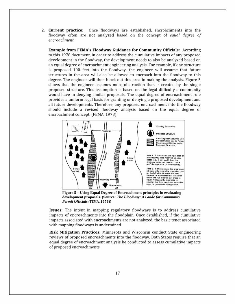
2. Current practice: Once floodways are established, encroachments into thefloodway often are not analyzed based on the concept of equal degree ofencroachment.ExamplefromFEMA’sFloodwayGuidanceforCommunityOfficials: Accordingtothis1978document,inordertoaddressthecumulativeimpactsofanyproposeddevelopmentinthefloodway,thedevelopmentneedstoalsobeanalyzedbasedonanequaldegreeofencroachmentengineeringanalysis.Forexample,ifonestructureis proposed 100 feet into the floodway, the engineer will assume that futurestructures in the area will also be allowed to encroach into the floodway to thisdegree.Theengineerwill thenblockoutthisareainmakingtheanalysis.Figure5shows that the engineer assumesmore obstruction than is created by the singleproposed structure. This assumption is based on the legal difficulty a communitywould have in denying similar proposals. The equal degree of encroachment ruleprovidesauniformlegalbasisforgrantingordenyingaproposeddevelopmentandall futuredevelopments.Therefore,anyproposedencroachment intothefloodwayshould include a revised floodway analysis based on the equal degree ofencroachmentconcept.(FEMA,1978)
Issues: The intent in mapping regulatory floodways is to address cumulativeimpacts of encroachments into the floodplain.Once established, if the cumulativeimpactsassociatedwithencroachmentsarenotanalyzed,thebasictenetassociatedwithmappingfloodwaysisundermined.
RiskMitigation Practices: Minnesota and Wisconsin conduct State engineeringreviewsofproposedencroachmentsintothefloodway.BothStatesrequirethatanequaldegreeofencroachmentanalysisbeconductedtoassesscumulativeimpactsofproposedencroachments.
Figure 5 – Using Equal Degree of Encroachment principles in evaluating development proposals. (Source: The Floodway: A Guide for Community Permit Officials(FEMA,1978))
18
3. Currentpractice: Wherea floodplainengineeringstudyhasbeencompletedandflood elevations have been established but floodways have not been mapped,development proposals often are not required to conduct a cumulative impactsanalysis.Issues:AccordingtoCFRTitle44,Part60,Section60.3(c)(10),communitiesmustrequirethatnonewconstruction,substantialimprovements,orotherdevelopment(including fill) shallbepermittedwithinZonesA1–30andAEon thecommunity’sFIRMuntil a regulatory floodway isdesignated,unless it isdemonstrated that thecumulative effect of the proposed development, when combined with all otherexistingandanticipateddevelopment,willnotincreasethewatersurfaceelevationofthebasefloodbymorethanonefootatanypointwithinthecommunity.RiskMitigationPractices:a. MinnesotaandWisconsinrequirenewdevelopmentproposalsinareaswithout
mappedfloodwaystoevaluatethecumulativeimpactofsimilardevelopmentbymapping a floodway as one of the first steps in the process. Minnesota hasespeciallysuccinctguidanceonevaluatingforcumulativeimpacts:“Compute the floodwaynecessary to conveyor store the regional floodwithoutincreasingfloodstagesmorethan0.58foot.Alesserstageincreasethan0.5'shallbe required if, as a result of the additional stage increase, increased flooddamageswould result. An equal degree of encroachment on both sides of thestreamwithinthereachshallbeassumedincomputingfloodwayboundaries.”
b. North Carolina has established flood elevations for all mapped Special Flood
Hazard Areas in the State. While all of these mapped SFHAs have floodelevations developed with an engineering model, many of them do not havemappedfloodways.Tomakeiteasierforcommunitiestoimplementfloodplainzoningintheseareas,NorthCarolinahasestablishednon‐encroachmentareasfor all streams lacking mapped floodways. Non‐encroachment stations havebeen determined at each modeled cross‐section by a hydraulic modelingtechniquesimilartotheprocessusedtodetermineregulatoryfloodwaywidths.However, thewidthshavenotbeenoptimizedbyrepeatedrunsof themodel.Therefore, the state requires that these surcharge values at individual cross‐sections be less than themaximum value of 1.0 feet allowed by 44 CFR 60.3(d)(2). North Carolina limits the surcharge to 0.7 feet unless the developerprovides an engineering study that includes amapped floodway. In thisway,communities can allow development landward of these non‐encroachmentareas and alsomeet the requirements in44CFR60.3 (c)(10) associatedwithSFHAsthathavefloodelevationsbutnofloodwaysidentified.
19
4. Currentpractice: FEMA’sGuidelinesandSpecifications includeguidanceonhowto develop a one‐foot rise floodway based on loss of storage. However, whenmappingregulatory floodwaysevaluating the lossof floodstorage isnot standardpractice.Issues: The floodplainprovidesavaluable functionbystoring floodwaters.Whenfillorbuildingsareplacedinthefloodfringe,floodstorageareasarelostandfloodheightswillincreasebecausethereislessroomforthefloodwaters.Thecumulativeimpacts of encroachments in the floodplain can actually bemore significant thanidentified in this assessment.As an example,MecklenburgCounty,NorthCarolinaanalyzed several watersheds in their jurisdiction to determine the cumulativeimpact of fill in the floodplain fringe on downstream flood depths due to loss offloodplain storage. The results of the Mecklenburg County study indicated thatbased on the standard NFIP regulations (maximum surcharge of one (1) foot),continuedin‐fillingofthefloodplainfringecouldresultinfloodelevationincreasesofupto2.3feet.(MecklenburgCounty,2008)RiskMitigationPractice:TheStateofIllinoishasenactedadministrativerulesforthenortheastportionoftheStateinwhichthefloodwayisdefinedas:thatportionof the channel and floodplainneeded to storeand convey the100‐year frequencyfloodeventwithnomorethan0.1footincreaseinstageduetolossoffloodstorage(emphasis added) and conveyance, and nomore than a 10% increase in velocity.DuPage County, Illinois (located in the northeastern portion of the State) hasadoptedfloodplainregulationsstatingthatanyplacementoffill,structures,orothermaterialsabovegradeinthefloodplainshallrequirecompensatorystorageequaltoatleast1.5timesthevolumeoffloodplainstoragedisplaced,andshallbeprovidedatthesameincrementalfloodfrequencyelevationasthefloodstoragedisplaced.
5. Current practice: The NFIP regulatory floodway—and any floodway that iscalculated using a hydraulic engineering model—is a hydraulic concept that isdesigned to prevent unacceptable increases in flood levels due to encroachmentsintotheNFIPSpecialFloodHazardArea.Theconceptdoesnotaddresshydrologicchanges that could increase flood levels such as the loss of floodplain storage,increaseinimpervioussurface,orchangesinprecipitationpatterns. Issues:OneoftheshortcomingsofFEMAFIRMsisthatthemappedfloodzonesarenotbasedonfuturelanduseconditions. RiskMitigationPractice: Charlotte‐Mecklenburg,NC–Toestimate thepotentialimpactsoflandusechanges,Charlotte‐MecklenburgStormWaterServicesassessedthe hydrologic conditions of severalwatersheds using both existing land use andfuture land use. The general conclusion of the land use change pilot study is thatflood depths would increase significantly for many of the watersheds. If thecommunity continued to regulate floodplain development under hydrologicconditionsbasedontheexisting landuse,asignificantnumberofbuildingswouldbe expected to be constructed in areas that would become floodplain when thewatersheds are re‐studied in future years.As a result, Charlotte‐Mecklenburg has
20
developed Floodplain Land Use Maps (FLUMs) based on projected future land use conditions, which are used for new development.
6. Current practice: The Special Flood Hazard Area depicted on FIRMs identifiesareasthatwillbe inundatedduringthebaseflood(theone‐percentannualchanceflood event). FEMA has developed guidelines and administrative rules associatedwith flood‐relatedhazardsother than inundationbut inmostcaseshavenotbeenauthorizedtoincludethemonFIRMs.Issues:Inundationisnottheonlyformofdamagefromflooding.Overtime,streamsmeanderlaterally,andfillordegradeverticallyastheyadjusttotheirwaterlevels,sediments,andslope.Streamchannelsmaychangesuddenlyandcatastrophically.RiskMitigation Practice: In Vermont, where erosion from flash flooding is themost expensive form of flood damage, the State has developed procedures formappingFluvialErosionHazardZonesandprovides incentives to communities toadoptthesemapstocomplementtheFEMAfloodinundationmapstoaddressfloodriskswithintheircommunity.Vermont’sdesignationofthesezonesasfloodwayhasbeenaffirmedbytheVermontStateSupremecourt.
7. Currentpractice:Whenevaluatingthepotentialimpactofencroachmentsintothefloodwaytheanalysisprimarilyfocusesonloseofconveyanceonly.Again,theNFIPregulatoryfloodwayisahydraulicconceptthatisdesignedtopreventunacceptableincreases in flood levelsduetoencroachments intotheNFIPSpecialFloodHazardArea. For encroachments that cause a surcharge that exceeds the acceptablethreshold,modificationstothefloodwayhydraulicstomitigatetheincreaseincludeincreasing the flow conveyance by reducing the roughness of the stream channeland/oradjacentfloodplain(U.S.ArmyCorpsofEngineers,1990). Issues:Removingnativevegetationandpavingtheareareducestheroughnessandallows the area to be constrictedwithout increasing flood heights. However, thisincreasesthefloodflowsvelocitiesandincreasestheerosivepropertiesofthefloodflows.Inaddition,itremovesvaluablenaturalhabitatinthefloodplain. RiskMitigationPractices:a. As stated previously, the State of Illinois has enacted administrative rules for
the northeast portion of the State in which the floodway is defined as: thatportionofthechannelandfloodplainneededtostoreandconveythe100‐yearfrequencyfloodeventwithnomorethan0.1footincreaseinstageduetolossofflood storage and conveyance, and no more than a 10% increase in velocity(emphasisadded).
b. Kenosha County, WI has adopted a floodplain overlay district in which theremoval of trees, shrubs and foliage from the Floodplain Overlay District isprohibited.