Embed Size (px)
DESCRIPTION
12547
Citation preview
21
1 Introduction
Pursuant to Annex II of the WFD, surface water must be divided into surface water bodies, and the mem-ber states must carry out a first characterization of these surface water bodies. Therefore, the surface water must first be divided into different categories. The WFD distinguishes the following categories: riv-ers, lakes, transitional waters and coastal waters.
Then, a typology must be developed for each cate-gory of surface water, and the water bodies must be delineated in a number of steps. The European CIS guidance document “Identification of water bodies” describes the general method to be followed.
In addition, type specific reference conditions must be established for these water bodies. In the paragraphs below, the terms “typology”, “wa-ter bodies” and “reference conditions” are described in short.
Paragraphs 2 to 5 of this chapter then give, per cat-egory, an overview of the typology and the delineat-ed water bodies. Then, the reference conditions that have already been developed per region are com-pared and the current quality of the surface water is described. Map 6 (p. 24) shows the categories and types of all surface waters in the district.
More detailed information about this, such as meth-ods used per region to work out the typology and to delineate the water bodies, can be found in the thematic report “Fresh surface water”, drawn up by project group P09, and in the thematic report “Coast-al and transitional water”, drawn up by project group P10.
1.1 Typology
The typology is used to characterize surface water on the basis of physical parameters that have an eco-logical relevance. For each water type, the specific reference conditions will be described that form the basis of an ecological assessment of the status of the surface water. This makes it possible to carry out validated, transnational comparisons of the ecologi-cal status of water bodies.
Annex II of the WFD offers the member states the choice between two surface water typification sys-
tems: system A and system B. If they use system B, the member states can define a number of optional descriptors, in addition to the obligatory descriptors. The typology resulting from system B must achieve at least the same degree of delineation as would be achieved using system A.
1.2 Water bodies
According to the CIS document “Identification of water bodies”, a number of steps must be followed to delineate the surface water bodies. The first two steps consist in classifying the surface waters in cat-egories and types. In the next steps, the surface wa-ters must be classified further on the basis of crite-ria to be established by the member states (physical characteristics, impact of significant pressures, a/o hydromorphological pressures, protection status, …).
Then, the delineation of water bodies consists in de-lineating a new water body whenever the value of a criterion changes in the surface water network. As a result, each water body must be homogeneous as regards the values of the established criteria. Going through these steps on the basis of the established criteria is considered as an iterative process.
1.3 Reference conditions
Pursuant to Annex II, § 1.3 of the WFD, for each type of surface water, type specific biological reference conditions must be established. The reference status of a surface water type is defined as the values of the quality elements reached in places that are found in the reference status, and which are therefore not subject to any human pressure. The high ecological status is reached when only very slight differences with respect to the reference status are observed.
The CIS guidance document “Guidance on establish-ing reference conditions and ecological status class boundaries for inland surface waters” describes a general method for establishing these reference con-ditions for fresh surface water. For coastal and transi-tional waters, the CIS guidance document “Typology, reference conditions and classification systems for transitional and coastal waters” is used.
For a surface water body, the classification according to ecological status must be done on the basis of Eco-logical Quality Ratios or EQR, which are established
II Surface water characterization
22
II. Surface water characterization
for biological quality elements. An ecological quality ratio expresses the ratio of the observed value of the biological parameter or index concerned with respect to the value of this parameter or index in the refer-ence status. The overall assessment of the ecological quality is further based on supporting physico-chemi-cal and hydromorphological elements.For rivers and lakes, the WFD takes into account the following biological quality elements: phytoplankton, macrophytes and phytobenthos, benthic invertebrate fauna and fish fauna. For transitional waters, they are phytoplankton, macro-algae, angiosperms, benthic invertebrate fauna and fish fauna; for coastal waters phytoplankton, macro-algae and angiosperms, and benthic invertebrate fauna.
1.4 Environmental objectives
Translated into environmental objectives, a good surface water status means that both the ecological status and the chemical status of the surface water are at least good. The reaching of a good ecologi-cal status or not by surface water is determined by a complex interaction of a whole series of factors. The ecological status is first reflected in biological elements: water flora, macro-invertebrates and fish fauna. The hydromorphological characteristics and the physico-chemical quality of surface water have a major impact on life in the water body. The combined effect of all these factors will determine the ecologi-cal status. The good chemical status requires that the environmental quality standards are met for a certain number of specific pollutants for which a standard has been or will be established at European level.
2 Rivers
2.1 Typology
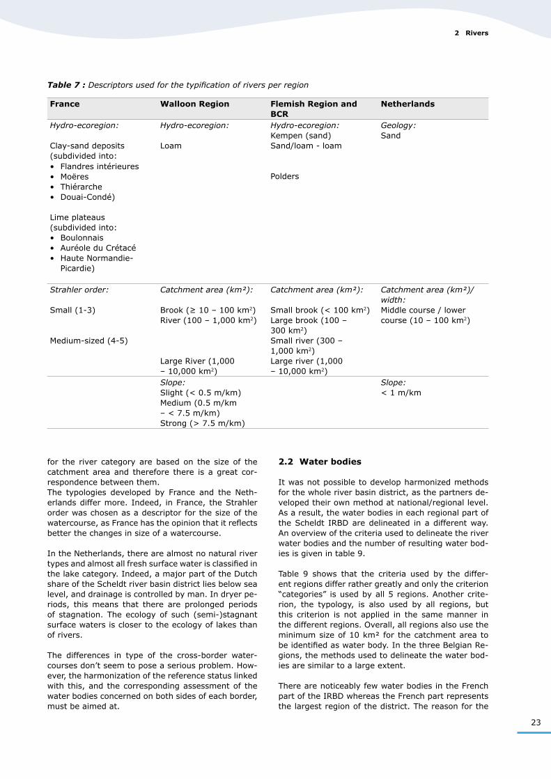
All Scaldit partners have used system B to establish a typology for rivers. No common types could be estab-lished yet for the Scheldt IRBD, because the partners used different descriptors, a/o because of different initial situations and because of national limitations. Table 7 gives an overview per region of the descrip-tors used for the typification of rivers. For the Flemish Region, Brussels Capital Region and Walloon Region, the typology was developed on a regional level, for France and the Netherlands, it was developed on a national level.
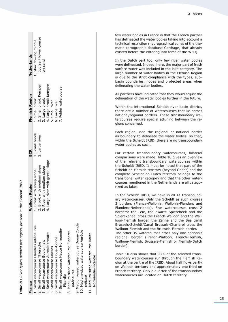
The use of the descriptors in table 7 enabled each re-gion to define a number of river types for its own part of the Scheldt IRBD. The types present in the Scheldt IRBD are given in table 8.
A comparison between the types defined per region shows that the ecological conditions for the Flemish and Dutch polder watercourses (see § 3 Lakes) and the French Moëres watercourses are approximately the same, so that further attuning of these types must be possible in the future. Therefore, the water characteristics and the ecological objectives should be similar.
The Dutch polder watercourses, however, were cate-gorized as lakes, while these surface waters in France and in the Flemish Region belong to river types. In the whole area from Dunkerque to Goerree-Overflak-kee, the characteristics of these watercourses are similar, as they all have a low flow rate and most of them are artificial or heavily modified waters.
It is also important to know that the river and brook types from the French clay-sand deposits (types 1, 2, 6, 8 and 9) are comparable to the types from the Flemish sand/loam – loam area (types 1, 3, 5 and 6) and the Walloon loam region (all types). The Kem-pen brooks in the Flemish Region (types 2 and 4) are similar to the middle course/lower course on sand in the Dutch typology.
However, in the Netherlands, this only concerns a few brooks in province Noord-Brabant. Almost all fresh surface waters in province Zeeland are artificial and classified in the lakes category.International attuning will focus on making the qual-ity objectives comparable.
It is also noteworthy that the Brussels Capital Region is surrounded completely by the Flemish Region. The Flemish and Brussels partners therefore decided to use the same typology.
In general, inside Belgium (Flemish Region, BCR and Walloon Region), the types that have been developed
23
2 Rivers
for the river category are based on the size of the catchment area and therefore there is a great cor-respondence between them. The typologies developed by France and the Neth-erlands differ more. Indeed, in France, the Strahler order was chosen as a descriptor for the size of the watercourse, as France has the opinion that it reflects better the changes in size of a watercourse.
In the Netherlands, there are almost no natural river types and almost all fresh surface water is classified in the lake category. Indeed, a major part of the Dutch share of the Scheldt river basin district lies below sea level, and drainage is controlled by man. In dryer pe-riods, this means that there are prolonged periods of stagnation. The ecology of such (semi-)stagnant surface waters is closer to the ecology of lakes than of rivers.
The differences in type of the cross-border water-courses don’t seem to pose a serious problem. How-ever, the harmonization of the reference status linked with this, and the corresponding assessment of the water bodies concerned on both sides of each border, must be aimed at.
Table 7 : Descriptors used for the typification of rivers per region
2.2 Water bodies
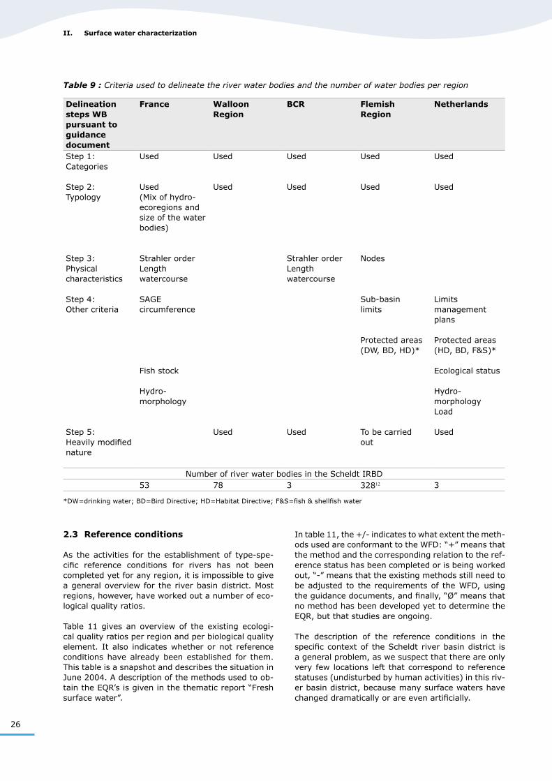
It was not possible to develop harmonized methods for the whole river basin district, as the partners de-veloped their own method at national/regional level. As a result, the water bodies in each regional part of the Scheldt IRBD are delineated in a different way. An overview of the criteria used to delineate the river water bodies and the number of resulting water bod-ies is given in table 9.
Table 9 shows that the criteria used by the differ-ent regions differ rather greatly and only the criterion “categories” is used by all 5 regions. Another crite-rion, the typology, is also used by all regions, but this criterion is not applied in the same manner in the different regions. Overall, all regions also use the minimum size of 10 km² for the catchment area to be identified as water body. In the three Belgian Re-gions, the methods used to delineate the water bod-ies are similar to a large extent.
There are noticeably few water bodies in the French part of the IRBD whereas the French part represents the largest region of the district. The reason for the
France Walloon Region Flemish Region and BCR
Netherlands
Hydro-ecoregion:
Clay-sand deposits(subdivided into: • Flandres intérieures• Moëres• Thiérarche• Douai-Condé)
Lime plateaus(subdivided into:• Boulonnais• Auréole du Crétacé• Haute Normandie-
Picardie)
Hydro-ecoregion:
Loam
Hydro-ecoregion:Kempen (sand)Sand/loam - loam
Polders
Geology:Sand
Strahler order:
Small (1-3)
Medium-sized (4-5)
Catchment area (km²):
Brook (≥ 10 – 100 km2)River (100 – 1,000 km2)
Large River (1,000 – 10,000 km2)
Catchment area (km²):
Small brook (< 100 km2)Large brook (100 – 300 km2)Small river (300 – 1,000 km2)Large river (1,000 – 10,000 km2)
Catchment area (km²)/ width:Middle course / lower course (10 – 100 km2)
Slope:Slight (< 0.5 m/km)Medium (0.5 m/km – < 7.5 m/km)Strong (> 7.5 m/km)
Slope:< 1 m/km
25
Tab
le 8
: R
iver
typ
es d
efined
per
reg
ion,
pre
sent
in t
he
Sch
eldt
IRBD
few water bodies in France is that the French partner has delineated the water bodies taking into account a technical restriction (hydrographical zones of the the-matic cartographic database Carthage, that already existed before the entering into force of the WFD).
In the Dutch part too, only few river water bodies were delineated. Indeed, here, the major part of fresh surface water was included in the lake category. The large number of water bodies in the Flemish Region is due to the strict compliance with the types, sub-basin boundaries, nodes and protected areas when delineating the water bodies.
All partners have indicated that they would adjust the delineation of the water bodies further in the future.
Within the international Scheldt river basin district, there are a number of watercourses that lie across national/regional borders. These transboundary wa-tercourses require special attuning between the re-gions concerned.
Each region used the regional or national border as boundary to delineate the water bodies, so that, within the Scheldt IRBD, there are no transboundary water bodies as such.
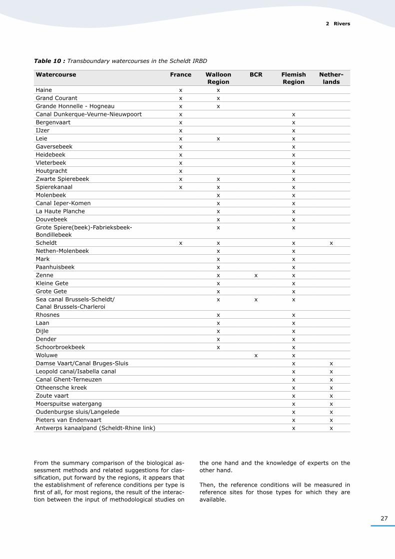
For certain transboundary watercourses, bilateral comparisons were made. Table 10 gives an overview of the relevant transboundary watercourses within the Scheldt IRBD. It must be noted that part of the Scheldt on Flemish territory (beyond Ghent) and the complete Scheldt on Dutch territory belongs to the transitional water category and that the other water-courses mentioned in the Netherlands are all catego-rized as lakes.
In the Scheldt IRBD, we have in all 41 transbound-ary watercourses. Only the Scheldt as such crosses 3 borders (France-Wallonia, Wallonia-Flanders and Flanders-Netherlands). Five watercourses cross 2 borders: the Leie, the Zwarte Spierebeek and the Spierekanaal cross the French-Walloon and the Wal-loon-Flemish border, the Zenne and the Sea canal Brussels-Scheldt/Canal Brussels-Charleroi cross the Walloon-Flemish and the Brussels-Flemish border. The other 35 watercourses cross only one national/regional border (French-Walloon, French-Flemish, Walloon-Flemish, Brussels-Flemish or Flemish-Dutch border).
Table 10 also shows that 93% of the selected trans-boundary watercourses run through the Flemish Re-gion at the centre of the IRBD. About half flows partly on Walloon territory and approximately one third on French territory. Only a quarter of the transboundary watercourses are located on Dutch territory.
Fra
nce
Wall
oo
n R
eg
ion
BC
RFle
mis
h R
eg
ion
Neth
erl
an
ds
1. Sm
all w
ater
cours
e Fl
andre
s in
térieu
res
2. Sm
all w
ater
cours
e Thié
rach
e3. Sm
all w
ater
cours
e Boulo
nnai
s4. Sm
all w
ater
cours
e Auré
ole
cré
tacé
5. Sm
all w
ater
cours
e M
oër
es6. Sm
all w
ater
cours
e D
ouai
-Condé
7. Sm
all w
ater
cours
e H
aute
Norm
andie
-Pi
card
ie8. M
ediu
m-s
ized
wat
erco
urs
e Fl
andre
s in
térieu
res
9. M
ediu
m-s
ized
wat
erco
urs
e D
ouai
-Condé
10.
Med
ium
-siz
ed w
ater
cours
e Auré
ole
cr
étac
é11.
Med
ium
-siz
ed w
ater
cours
e H
aute
N
orm
andie
-Pic
ardie
1. Bro
ok
with s
teep
slo
pe
2. Bro
ok
with m
ediu
m s
lope
3. Riv
er w
ith m
ediu
m s
lope
4. La
rge
rive
r w
ith g
entle
slope
1. Sm
all bro
ok
2. La
rge
rive
r1. Sm
all bro
ok
2. Sm
all bro
ok
Kem
pen
3. La
rge
bro
ok
4. La
rge
bro
ok
Kem
pen
5. Sm
all rive
r6. La
rge
rive
r7. Po
lder
wat
erco
urs
e
1. Slo
w fl
ow
ing m
iddle
co
urs
e /
low
er c
ours
e on s
and
2 Rivers
26
II. Surface water characterization
Delineation steps WB pursuant to guidance document
France Walloon Region
BCR Flemish Region
Netherlands
Step 1: Categories
Step 2: Typology
Step 3: Physical characteristics
Step 4: Other criteria
Step 5: Heavily modified nature
Used
Used(Mix of hydro-ecoregions and size of the water bodies)
Strahler orderLength watercourse
SAGE circumference
Fish stock
Hydro-morphology
Used
Used
Used
Used
Used
Strahler orderLength watercourse
Used
Used
Used
Nodes
Sub-basin limits
Protected areas (DW, BD, HD)*
To be carried out
Used
Used
Limits management plans
Protected areas (HD, BD, F&S)*
Ecological status
Hydro-morphologyLoad
Used
Number of river water bodies in the Scheldt IRBD53 78 3 32812 3
*DW=drinking water; BD=Bird Directive; HD=Habitat Directive; F&S=fish & shellfish water
Table 9 : Criteria used to delineate the river water bodies and the number of water bodies per region
2.3 Reference conditions
As the activities for the establishment of type-spe-cific reference conditions for rivers has not been completed yet for any region, it is impossible to give a general overview for the river basin district. Most regions, however, have worked out a number of eco-logical quality ratios.
Table 11 gives an overview of the existing ecologi-cal quality ratios per region and per biological quality element. It also indicates whether or not reference conditions have already been established for them. This table is a snapshot and describes the situation in June 2004. A description of the methods used to ob-tain the EQR’s is given in the thematic report “Fresh surface water”.
In table 11, the +/- indicates to what extent the meth-ods used are conformant to the WFD: “+” means that the method and the corresponding relation to the ref-erence status has been completed or is being worked out, “-” means that the existing methods still need to be adjusted to the requirements of the WFD, using the guidance documents, and finally, “Ø” means that no method has been developed yet to determine the EQR, but that studies are ongoing.
The description of the reference conditions in the specific context of the Scheldt river basin district is a general problem, as we suspect that there are only very few locations left that correspond to reference statuses (undisturbed by human activities) in this riv-er basin district, because many surface waters have changed dramatically or are even artificially.
27
Table 10 : Transboundary watercourses in the Scheldt IRBD
Watercourse France Walloon Region
BCR Flemish Region
Nether-lands
Haine x xGrand Courant x xGrande Honnelle - Hogneau x xCanal Dunkerque-Veurne-Nieuwpoort x xBergenvaart x xIJzer x xLeie x x xGaversebeek x xHeidebeek x xVleterbeek x xHoutgracht x xZwarte Spierebeek x x xSpierekanaal x x xMolenbeek x xCanal Ieper-Komen x xLa Haute Planche x xDouvebeek x xGrote Spiere(beek)-Fabrieksbeek-Bondillebeek
x x
Scheldt x x x xNethen-Molenbeek x xMark x xPaanhuisbeek x xZenne x x xKleine Gete x xGrote Gete x xSea canal Brussels-Scheldt/ Canal Brussels-Charleroi
x x x
Rhosnes x xLaan x xDijle x xDender x xSchoorbroekbeek x xWoluwe x xDamse Vaart/Canal Bruges-Sluis x xLeopold canal/Isabella canal x xCanal Ghent-Terneuzen x xOtheensche kreek x xZoute vaart x xMoerspuitse watergang x xOudenburgse sluis/Langelede x xPieters van Endenvaart x xAntwerps kanaalpand (Scheldt-Rhine link) x x
From the summary comparison of the biological as-sessment methods and related suggestions for clas-sification, put forward by the regions, it appears that the establishment of reference conditions per type is first of all, for most regions, the result of the interac-tion between the input of methodological studies on
the one hand and the knowledge of experts on the other hand.
Then, the reference conditions will be measured in reference sites for those types for which they are available.
2 Rivers
28
II. Surface water characterization
As the development of methods by the partners hasn’t progressed enough yet, a thorough compari-son is still impossible.
On European level, an intercalibration exercise is on-going aimed at enabling a comparison between the classification used by the different member states to determine the ecological status.
This exercise is coordinated by the European Commis-sion and first of all consists in establishing an inter-calibration network containing locations in all existing types of surface water bodies. Here, ‘types’ refers to the typology developed at European level.
In this intercalibration register (provisional version of 24/5/2004), the following points, located in the Scheldt IRBD, have been included for the river cat-egory:• type R-C1: 36BE Burggravenstroom 1, 37BE IJsse,
38BE Kleine Nete 2, 52BE Grande Honnelle• type R-C4: 43BE Grote Nete 1, 44BE IJzer, 45BE
IJzer 1, 46BE Kleine Nete 1, 47BE Laan• type R-C6: 390FR Aa-Wizernes, 389FR Liane-Hes-
digneul, 424FR Hem-RecquesBecause of the lack of “natural” water bodies on its territory, the Brussels Capital Region has not put any points in the intercalibration register.
In a next stage, the monitoring systems of the mem-ber states will be applied on the selected intercalibra-tion points that are relevant for the member state concerned and the results of this exercise will be used to determine the values of the class boundaries in the monitoring system.
Biological quality element
France Walloon Region
BCR Flemish Region Netherlands
Benthic invertebrate fauna
IBGN
+
IBGN
+
Ø Revised BBI
+
Criterion macro-fauna
-Macrophytes IBMR
-Ø Ø MAFWAT
+ Criterion macrophytes and
phytobenthos
+
Phytobenthos IBD
+
IPS
-
Ø IBDIPS
(SLAD)(TDI)
-Fish fauna IPR
+IBIP
-Ø IBI
-Criterion fish
-Phytoplankton Ø Ø Ø Ø Not applicable
IBGN=Indice Biologique Global Normalisé; BBI=Belgische Biotische Index; IBMR=Indice Biologique Macrophytique en Rivière; IBD=Indice Biologique Diatomées; MAFWAT=Multi-metric Method for Macrophytes in Watercourses; IPS=Indice de Polluo-Sensibilité; SLAD=Sladeçek; TDI=Trophic Diatom Index; IPR=Indice Poisson Rivière; IBI=Index voor Biotische Integriteit; IBIP=Indice Biologique d’Intégrité Piscicole
Table 11 : Overview of the existing calculation methods for ecological quality ratios (EQR) for rivers per re-gion
29
2.4 Current quality
2.4.1 Existing monitoring networks
2.4.1.1 Homogeneous monitoring network
The quality of the Scheldt water is followed-up in a harmonized manner through the homogeneous mon-itoring network that was put into action by the parties within the framework of their cooperation within the International Scheldt Commission.
This monitoring network is operational since 1 Janu-ary 1998 and has the following starting points:
• Comparability of the measurements for a single parameter:
from sampling to analysis, the same protocols are followed strictly and are assessed regularly.
• Cooperation principle: each party has its own laboratory that carries out
the analysis of samples taken in its own measuring points. The results are given to the French partner, who includes them in a database.
• Synchronisation principle: the samplings take place every four weeks, on the
same day, and every three years for the biological parameter.
• Transparency principle: everyone has access to all data of the homogene-
ous monitoring net.
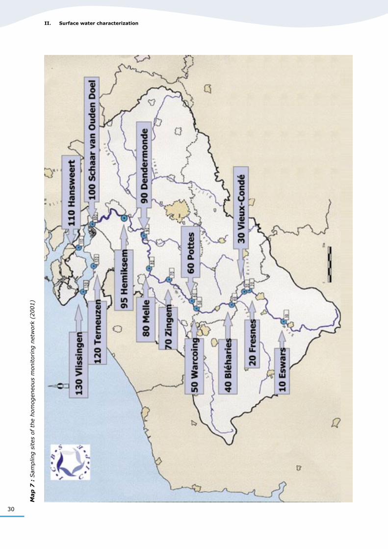
Currently, the homogeneous monitoring network con-sists of 14 sampling sites, all located on the Scheldt. These sampling sites are partly located in the “river” category and partly in the “transitional water” cat-egory. The boundary between both categories is lo-cated at the Gentbrugge lock near Ghent. This is the place up to which the tidal action has an effect.
Seven sampling sites are located in the first cate-gory (numbers 10, 20, 30, 40, 50, 60 and 70) and the seven others are located in the second category (numbers 80, 90, 95, 100, 110, 120 and 130). Three of the seven transitional water sites are located in the freshwater tidal area (80, 90 and 95), while in the four other locations, the influence of salt water is determining (100, 110, 120 and 130). Map 7 shows the location of these sampling sites.
Currently, the homogeneous monitoring network of the Scheldt covers 32 parameters. From the samples taken in the homogeneous network, 28 parameters are analysed. During sampling, there are four ad-ditional measurements in the field. The table below gives an overview of these parameters and of the unit in which the test results are expressed.
Parameter Unit
Measurements in the fieldTemperature °CpH u.pHConductivity at 25°C µS/cmO2 (dissolved oxygen) % and mg/l
Analyses
NO2- (nitrite) mgN/l
NO3- (nitrate) mgN/l
NH3 (ammonia) mgN/lNH4
+ (ammonium) mgN/lN-Kjeldahl (Kjeldahl nitrogen) mgN/lN-total (total nitrogen) mgN/lP-total (total phosphorus) mgP/lOrtho-PO4
3- (orthophosphate) mgP/lCl- (chloride) mg/lSO4
2- (sulphate) mg/lSS (suspended solids) mg/lBOD5 (Biochemical Oxygen Demand) mgO2/lCOD (Chemical Oxygen Demand) mgO2/lChlorophyll-a µg/lBiological index** scoreCd (cadmium)* µg/lCu (copper) µg/lZn (zinc) µg/lAtrazine* µg/lSimazine* µg/lLindane* µg/lDiuron* µg/lFluoranthene* µg/lBenzo(b)fluoranthene* µg/lBenzo(k)fluoranthene* µg/lBenzo(a)pyrene* µg/lBenzo(ghi)perylene* µg/lIndeno(123cd)pyrene* µg/l
*Priority substances pursuant to Annex X of the WFD**Invertebrate index, assessed every 3 years, only in fresh surface water
2.4.1.2 Regional monitoring networks
In addition to the homogeneous monitoring net-work, many other monitoring networks are used in the Scheldt IRBD, which are the responsibility of the riparian regions. These monitoring networks will need to be adapted according to the specific monitoring obligations imposed by the WFD (art. 8) by the end of 2006.
All regions now have a region-wide physico-chemical monitoring network. This is not the case yet for all biological quality elements. Table 12 gives an over-view of the existing biological monitoring networks per region. There is also an indication whether or not these monitoring networks already meet the 2006
2 Rivers
30
II. Surface water characterization
Map
7 :
Sam
plin
g s
ites
of
the
hom
ogen
eous
monitoring n
etw
ork
(2001)
31
requirements of the WFD and whether these already cover the whole region concerned.
In table 12, columns “p-c” indicate whether the type of monitoring network concerned is already present, and if so, whether it already meets the provisions of the WFD to be met by 2006 (conformity). Here, “J” indicates that a monitoring network exists for the element concerned and that it already meets the re-quirements of the WFD for 2006, “K” means that the monitoring network exists, but that it doesn’t meet the requirements of the WFD to be met by 2006 and “L” means that there is no monitoring network yet for the element concerned. Columns “e” indicate whether the existing network covers the entire re-gion or not.
As shown in table 12, only the Netherlands have a monitoring network for macrophytes and for phyto-plankton and, until now, the monitoring networks for macro-invertebrates are the most developed. The intercalibration exercise described earlier will be ap-plied to the above monitoring networks in order to test the comparability of the class boundaries estab-lished by the different member states.
2.4.2 Quality of the watercourses
2.4.2.1 The Scheldt
An analysis of the monitoring results of the homoge-neous monitoring network for the period 1998-2002 is included in the “Report on the water quality of the Scheldt” by the ISC. This report concludes that an improvement has been observed for many param-eters over the years. However, according to the re-port, these observed improvements can mainly be attributed to an increased drainage in 2001 and 2002 as a result of heavy rainfall. It also concludes that the considerable improvement for nitrogen (total and ammoniacal nitrogen) is due to the commissioning of adequate water treatment plants and to the reduc-tion of certain industrial discharges.
Table 12 : Overview of the existing biological monitoring networks per region
Monitoring network typeMacro-
invertebratesFish Phytobenthos
(diatoms)Macrophytes Phytoplankton
p-c e p-c e p-c e p-c e p-c eFrance K yes K no K yes L L
Walloon Region K yes L K yes L L
BCR L L L L L
Flemish Region K yes K yes L L L
Netherlands J no L L J no J no
From the results of two monitoring campaigns for bi-ological elements (diatoms in 2000 and benthic mac-ro-invertebrates in 2002), we can also conclude that the biological water quality is moderate to bad.The evolution of the water quality in the Scheldt still rests on a very unstable balance that is influenced by natural factors (such as rainfall).
2.4.2.2 Transboundary watercourses
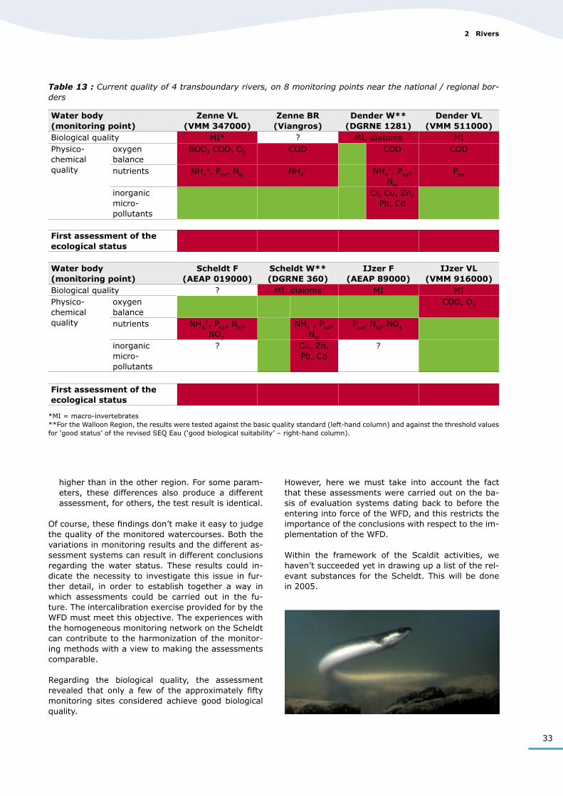
For the description of the current quality of wa-tercourses that cross or form borders between re-gions/countries, the data for the year 2002 (2000 for France) produced by the monitoring networks de-scribed under § 2.4.1 are used and in 5 transbound-ary watercourses (Zenne, Scheldt F-W, Dender, IJzer and Scheldt VL-NL), two points on both sides of the border have been selected each time.
For the selected monitoring points, the following parameters were compared: dissolved oxygen, bio-chemical oxygen demand, chemical oxygen demand, ammonium, Kjeldahl nitrogen, nitrate, total phos-phate, copper, zinc, chromium, arsenic, cadmium, mercury, lead and nickel (the last 4 are priority sub-stances pursuant to Decision N° 2455/2001/EC). Whenever available, data concerning biological qual-ity elements were compared for a larger number of transboundary watercourses.
Then, the monitoring results collected for the phys-ico-chemical parameters were tested against the standards existing in the different riparian regions. For the Flemish Region, the Walloon Region and the BCR, these are the basic quality standards, for the Netherlands the standards from the Fourth Note on Water Management. For France, the results were tested against the threshold values for the level ‘good status’ in the ‘Système d’Evaluation de la Qualité de l’eau’ (SEQ-Eau). For the Walloon Region, a second test was carried out (second column for Dender W and Scheldt W – see table 13) on the basis of a re-vised and provisional version of the SEQ-Eau.
2 Rivers
32
II. Surface water characterization
The monitoring results for the 10 selected monitoring points, details concerning the standards used and the results of the test against the standards can be found in the thematic report “Fresh surface water”.
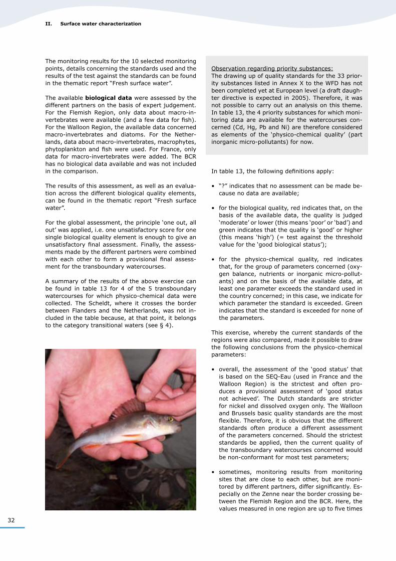
The available biological data were assessed by the different partners on the basis of expert judgement. For the Flemish Region, only data about macro-in-vertebrates were available (and a few data for fish). For the Walloon Region, the available data concerned macro-invertebrates and diatoms. For the Nether-lands, data about macro-invertebrates, macrophytes, phytoplankton and fish were used. For France, only data for macro-invertebrates were added. The BCR has no biological data available and was not included in the comparison.
The results of this assessment, as well as an evalua-tion across the different biological quality elements, can be found in the thematic report “Fresh surface water”.
For the global assessment, the principle ‘one out, all out’ was applied, i.e. one unsatisfactory score for one single biological quality element is enough to give an unsatisfactory final assessment. Finally, the assess-ments made by the different partners were combined with each other to form a provisional final assess-ment for the transboundary watercourses.
A summary of the results of the above exercise can be found in table 13 for 4 of the 5 transboundary watercourses for which physico-chemical data were collected. The Scheldt, where it crosses the border between Flanders and the Netherlands, was not in-cluded in the table because, at that point, it belongs to the category transitional waters (see § 4).
Observation regarding priority substances: The drawing up of quality standards for the 33 prior-ity substances listed in Annex X to the WFD has not been completed yet at European level (a draft daugh-ter directive is expected in 2005). Therefore, it was not possible to carry out an analysis on this theme. In table 13, the 4 priority substances for which moni-toring data are available for the watercourses con-cerned (Cd, Hg, Pb and Ni) are therefore considered as elements of the ‘physico-chemical quality’ (part inorganic micro-pollutants) for now.
In table 13, the following definitions apply:
• “?” indicates that no assessment can be made be-cause no data are available;
• for the biological quality, red indicates that, on the basis of the available data, the quality is judged ‘moderate’ or lower (this means ‘poor’ or ‘bad’) and green indicates that the quality is ‘good’ or higher (this means ‘high’) (= test against the threshold value for the ‘good biological status’);
• for the physico-chemical quality, red indicates that, for the group of parameters concerned (oxy-gen balance, nutrients or inorganic micro-pollut-ants) and on the basis of the available data, at least one parameter exceeds the standard used in the country concerned; in this case, we indicate for which parameter the standard is exceeded. Green indicates that the standard is exceeded for none of the parameters.
This exercise, whereby the current standards of the regions were also compared, made it possible to draw the following conclusions from the physico-chemical parameters:
• overall, the assessment of the ‘good status’ that is based on the SEQ-Eau (used in France and the Walloon Region) is the strictest and often pro-duces a provisional assessment of ‘good status not achieved’. The Dutch standards are stricter for nickel and dissolved oxygen only. The Walloon and Brussels basic quality standards are the most flexible. Therefore, it is obvious that the different standards often produce a different assessment of the parameters concerned. Should the strictest standards be applied, then the current quality of the transboundary watercourses concerned would be non-conformant for most test parameters;
• sometimes, monitoring results from monitoring sites that are close to each other, but are moni-tored by different partners, differ significantly. Es-pecially on the Zenne near the border crossing be-tween the Flemish Region and the BCR. Here, the values measured in one region are up to five times
33
Table 13 : Current quality of 4 transboundary rivers, on 8 monitoring points near the national / regional bor-ders
Water body(monitoring point)
Zenne VL(VMM 347000)
Zenne BR(Viangros)
Dender W**(DGRNE 1281)
Dender VL(VMM 511000)
Biological quality MI* ? MI, diatoms MIPhysico-chemical quality
oxygen balance
BOD, COD, O2 COD COD COD
nutrients NH4+, Ptot, NKj NH4
+ NH4+, Ptot, NKj
Ptot
inorganic micro-pollutants
Cr, Cu, Zn, Pb, Cd
First assessment of the ecological status
Water body(monitoring point)
Scheldt F(AEAP 019000)
Scheldt W**(DGRNE 360)
IJzer F(AEAP 89000)
IJzer VL(VMM 916000)
Biological quality ? MI, dialoms MI MIPhysico-chemical quality
oxygen balance
COD, O2
nutrients NH4+, Ptot, NKj, NO3
-
NH4+, Ptot, NKj
Ptot, NKj, NO3-
inorganic micro-pollutants
? Cu, Zn, Pb, Cd
?
First assessment of the ecological status
*MI = macro-invertebrates**For the Walloon Region, the results were tested against the basic quality standard (left-hand column) and against the threshold values for ‘good status’ of the revised SEQ Eau (‘good biological suitability’ – right-hand column).
higher than in the other region. For some param-eters, these differences also produce a different assessment, for others, the test result is identical.
Of course, these findings don’t make it easy to judge the quality of the monitored watercourses. Both the variations in monitoring results and the different as-sessment systems can result in different conclusions regarding the water status. These results could in-dicate the necessity to investigate this issue in fur-ther detail, in order to establish together a way in which assessments could be carried out in the fu-ture. The intercalibration exercise provided for by the WFD must meet this objective. The experiences with the homogeneous monitoring network on the Scheldt can contribute to the harmonization of the monitor-ing methods with a view to making the assessments comparable.
Regarding the biological quality, the assessment revealed that only a few of the approximately fifty monitoring sites considered achieve good biological quality.
2 Rivers
However, here we must take into account the fact that these assessments were carried out on the ba-sis of evaluation systems dating back to before the entering into force of the WFD, and this restricts the importance of the conclusions with respect to the im-plementation of the WFD.
Within the framework of the Scaldit activities, we haven’t succeeded yet in drawing up a list of the rel-evant substances for the Scheldt. This will be done in 2005.
34
II. Surface water characterization
3 Lakes
3.1 Typology
To establish a typology for lakes, the Netherlands, France and the Flemish Region have used system B. There are no lakes larger than 50 ha in the Brussels part and in the Walloon part of the Scheldt IRBD. This is the lower size limit for lakes provided for by the WFD. Therefore, no typology was developed for these parts of the river basin district.
Given the great difference in factors used per region, no common types could be developed. Table 14 gives an overview per region of the descriptors used for the typification of lakes. For the Flemish Region, the ty-pology was developed on a regional level, for France and the Netherlands on a national level.
By applying the descriptors in table 14, it was possi-ble to define a number of types per region. The types that are found in the Scheldt IRBD are listed in table 15.
Table 15 : Defined lake types per region, present in the Scheldt IRBD
France Flemish Region Netherlands1. Lakes formed by excavation, in
hard rock, not drainable2. Shallow lake, obtained by
excavation, in the high water bed of a watercourse, connected with the aquifer, L-shaped, without thermocline
3. Lake in plain or medium highland, on impenetrable substrate, fed by springs, temporary watercourses or class 1 or 2 watercourse, usually not drained, but controlled hydraulic management
1. Moderatly ion rich, alkaline waters
2. Large, deep, alkaline waters
1. Buffered ditches2. Weakly buffered ditches3. Shallow, weakly buffered pools4. Medium-sized, deep, buffered
lakes5. Weakly brackish waters6. Small, brackish to brinish
waters7. Large, brackish to brinish lakes
Observation: Types 1 and 2 are the polder watercourses discussed under § 2.1
Table 14 : Descriptors used for the typification of lakes per region (there are no lakes in the Brussels and Wal-loon part of the river basin district)
France Flemish Region NetherlandsSalinity:0 – 0.3 g Cl/l0.3 – 3 g Cl/l 3 – 10 g Cl/l> 10 g Cl/lForm, geology:Non-linear or linear, > 50% siliceous
Area:
> 50 ha
Area:
> 50 ha
Area/Width:< 50 ha50 – 10,000 haWider than or narrower than 8 m
Depth:< 3 m3 – 15 m
Depth:< or > 3 m deep (criterion only applicable if < 0.3 g Cl/l)
Buffer capacity:weakly buffered 0.1 – 1 meq/lbuffered 1 – 4 meq/l
35
Because it is very difficult to develop a typology for lakes in a simple and ecologically consistent manner, and because it seems much more dependent on local criteria, it was practically impossible to compare the lake types from the different regions.
The lakes are also so different, that comparison offers little added value (France: artificial freshwater lakes > 50 ha; Flemish Region: freshwater lakes, mostly artificial > 50 ha; Walloon Region and BCR: no lakes; Netherlands: brinish/brackish lakes, whereby those < 50 ha have also been taken into account).
Moreover, in the Scheldt IRBD, there are no trans-boundary lakes. Bilateral attuning between the Flem-ish Region and the Netherlands will be needed, how-ever, for a number of transboundary canals, the eco-logical potential of which will probably be compared to a lake type: Canal Ghent-Terneuzen, Scheldt-Rhine link and Canal Bruges-Sluis.
3.2 Water bodies
For the French and Flemish part of the IRBD, the physical boundary was taken as sole criterion to de-
lineate the lake water bodies. For the Dutch part of the Scheldt IRBD, additional criteria must be used, as the Dutch lake water bodies are partly linear waters and therefore not lakes in the usual sense. Here, the existing classification into water systems (based on the hydrological characteristics) was used in addition to the geographical characteristics (such as dykes, dams, breakwaters, locks and other gates).
Table 16 gives an overview of the number of deline-ated lake water bodies in the different parts of the river basin district.
As mentioned under § 3.1, the lakes in the IRBD of the Scheldt have hardly any common characteristics.
3.3 Reference conditions
For lakes, type-specific reference conditions must be worked out, just like for rivers.The activities regarding the establishment of refer-ence conditions for lakes are less advanced than for rivers, and we can’t give a general overview for the river basin district either. Some regions, however, have developed a number of ecological quality ra-tios.
Table 17 gives an overview of the existing ecological quality ratios per region and per biological quality el-ement, and indicates whether or not reference condi-tions have been established for them. A description of the methods used to obtain the EQR’s can be found in the thematic report “Fresh surface water”.
In table 17, “R” means that for the biological qual-ity element concerned type-specific reference condi-tions have already been developed, “Ø” means that no method exists yet to determine the EQR.
As shown in table 17, the Dutch partner is the only one who has progressed considerably in working out ecological quality ratios for lakes. A large part of the fresh surface water in the Dutch part of the IRBD is also categorized as lake. Therefore, the lake category has a much more prominent presence in the Dutch part and has a much greater importance than in the other parts of the river basin district.
In the European intercalibration register (provisional version of 24/5/2004), the following points located in the Scheldt IRBD have been included in the lake category:• type L-CE1: 18BE Gavers – Harelbeke• type L-CE2: 17BE Blokkersdijk, 20BE Torfbroek
– Berg• type L-CE3: 19BE Groot Schietveld – Wuustwezel
Table 17 : Overview of the existing ecological quality ratios (EQR) for lakes per region
Biological quality element
France Flemish Region
Netherlands
Benthic in-vertebrate fauna
Ø Ø Criterion macro-fauna
(R)Macro-phytes
Ø MAFST(R for 1 type)
Criterion macrophytes
and phytobenthos
(R)Phyto-benthos
Ø Ø
Fish fauna Ø Ø Criterion fishPhyto-plankton
Ø Ø Criterion phytoplankton
MAFST=multimetric method for macrophytes in standing waters
Table 16 : Number of lake water bodies per region (there are no lakes in the Brussels and Walloon parts of the river basin district)
Number of lake water bodies
France 3Flemish Region 14Netherlands 64DISTRICT 81
3 Lakes
36
II. Surface water characterization
4 Transitional waters
4.1 Typology
All regions in the Scheldt river basin district opted for system B to establish a typology for transitional waters.
The cooperation within Scaldit has resulted in a com-mon transnational typification of transitional waters in the Scheldt river basin district, based on the Eu-ropean recommendations. The water types were es-tablished in the way proposed by the CIS guidance document “Typology, reference conditions and classi-fication systems for transitional and coastal waters”, § 3.5. The determining physical parameters used for the typification of transitional water are the following:• salinity;• tidal range;• composition of the substrate;• velocity.
The application of these descriptors has resulted in the identification of five types of transitional waters for the entire Scheldt IRBD. Table 18 gives an over-view of the five defined types.
Table 18 : Defined types of transitional water in the Scheldt IRBD
Type Type descriptionType 1 macro-tidal, mixed sediment, medium
to high velocity (estuary)Type 2 meso-tidal, silt and sandy sediment,
high velocity (estuary)Type 3 macro-tidal, silt and sandy sediment,
low velocity (estuary)Type 4* macro-tidal, silt and sandy sediment,
low velocity (port)Type 5* macro-tidal, silt and sandy sediment,
medium to high velocity (port)
*In France, the typology was simplified at the national level. This resulted in the merger of (local) types 4 and 5 into a single type at national level: “large, macro-tidal ports”.
4.2 Water bodies
Before we can apply the typology, the categories to which the water bodies belong must be established. This is done by establishing boundaries in the surface water between transitional water, coastal water and freshwater, on the basis of several criteria. The boundary between categories coastal water and transitional water can be determined in several ways, i.e. on the basis of:• European or national legislation;• the salt content (salinity);• physical or geographical characteristics.
3.4 Current quality
A lot less information is available about the current quality of lake water bodies than about the river wa-ter bodies. In France and in the Flemish Region, no permanent monitoring points in lakes have been in-cluded in the existing monitoring networks, and only results of studies are available. As a result it is difficult to judge the current quality of lake water bodies.
Monitoring results are only available for the Dutch part of the Scheldt IRBD, where almost all fresh sur-face waters are considered as lakes. For this, we refer to the Dutch art. 5 report.
37
For the boundary between fresh surface water and transitional water, we can use either the salt/fresh boundary or the tidal boundary, depending on the boundary that best suits the local conditions.
We can conclude that all regions in the river basin dis-trict were able, with the boundaries or starting points put forward by the WFD, to establish the boundaries between coastal and transitional waters. Here, we must indicate that locks and differentiations provid-ed for in the national legislations were also used as boundary between river and transitional water. Table 19 shows an overview of the boundaries used.
Ten transitional water bodies were identified in the Scheldt river basin district. Table 20 gives, per re-gion, which transitional water bodies were delineated and to which type these water bodies belong.
In the Scheldt IRBD, there is one transitional water with a transboundary nature, i.e. the transitional wa-ter Scheldt (TWSB1) – Westerschelde (TWSN1). How-
ever, the national border has been used to delineate the water bodies, so that, within the Scheldt IRBD, they are considered as ‘neighbouring water bodies of the same type’, instead of transboundary water bod-ies. Here, we must also indicate that the transitional water body ‘Scheldt and tidal linked tributaries’ on the Flemish territory, that has been clustered for Scaldit purposes, in fact consists of several water bodies.
We can conclude that all transitional waters in the Scheldt river basin district are delineated and typified in an unequivocal, comparable manner. For the iden-tified neighbouring water bodies of the same type, we will then aim at transnational agreements regarding the objectives and measures to be taken.
4.3 Reference conditions
It is currently impossible to compare the available references for transitional waters in the Scheldt river basin district. This is due to the different methods used in the different countries to establish the refer-ence conditions. It was impossible to harmonize the methods because this requires thorough scientific consultation beyond the scope of Scaldit.
There are good opportunities to learn from each oth-er’s approach during further cooperation and to enrich the national debate in order to reach a comparable description of the reference conditions. The search for coherence is important, a/o, for the neighbouring water bodies of the same type, like the Scheldt estu-ary. First of all, the national methods are based on the following elements:
• In the Netherlands, provisional reference condi-tions for transitional waters and a classification (classes ranging from ‘high status’ to ‘bad sta-tus’) per biological quality element have been es-tablished. This is based on expert judgement and available (historic) information on the quality ele-
Table 20 : Delineated transitional water bodies per region.
Delineated transitional water body Type of water body (see table 18)
France 1. Somme (estuary) (TWSF1)*2. Dunkerque (port) (TWSFDK)*3. Calais (port) (TWSFCL)*4. Boulogne (port) (TWSFBL)*
type 3type 4type 4type 5
Flemish Region 1. IJzer (estuary) (TWSB2)*2. Scheldt and tidal linked tributaries
(cluster) (TWSB1)*3. Zeebrugge (port)4. Blankenberge (port)5. Ostend (port)
type 2type 1
not typified (artificial)not typified (artificial)not typified (artificial)
Netherlands 1. Westerschelde (TWSN1)* type 1
*Code used for the water body
4 Transitional waters
Table 19 : Boundaries used to delineate coastal and transitional water bodies
Boundary between Criterion usedCoastal water and transitional water
Salinity, hydrology or physiographical characteristic
Transitional water and fresh surface water
Locks, tidal limits, national legislation
Coastal waters Typology, flood barrierTransitional water and land
Dykes
Coastal water and land High water lineCoastal water and fresh surface water
National legislation, physiographical characteristic
38
II. Surface water characterization
ments. No references have been described yet for the physico-chemical quality elements. For now, the national standards for these elements (sub-stances) are used. There are no natural reference locations for transitional water in the Dutch part of the Scheldt river basin district.
• The Flemish Region has developed provisional ref-erence conditions and a classification system in five classes to describe the biological quality ele-ments. Expert judgement, historic information and a scientific approach of the working of an estuary system were used to set up the classification. No references have been described yet for the physi-co-chemical quality elements. There are no natu-ral reference locations for transitional water in the Flemish part of the Scheldt river basin district.
• As yet, France doesn’t have any reference condi-tions or classification system in five classes for the biological quality elements as prescribed by the WFD. The ecological quality is assessed through a simplified approach. On the basis of expert judge-ment, completed with data where these are avail-able, it is assessed whether the current quality is ‘close’ or ‘remote’ from undisturbed conditions. This applies for biological and for physico-chemical quality elements. For some types of water bodies and certain biological quality elements, natural lo-cations for transitional water have been identified
Table 21 : Current ecological quality of the transitional water bodies
Water body Somme (estuary)
(F)
Boulogne (port)
(F)
Calais (port)
(F)
Duinkerke (port)
(F)
Scheldt and tidal
linked tributaries
(VL)
Wester-schelde
(NL)Biological quality phyto-
plankton(for 60-
70% of the territory)
benthic fauna (for 70% of the territory)
benthic fauna,
macro-algae
phyto-plankton, macro-
fauna, fish
phytoplank-ton, macro-fauna, ma-cro-algae,
fishPhysico-chemical quality
oxygen balance
O2 T, O2 susp. matter, O2
nutrients N N, P N, P N, P
micro-pollutants
Cd, Hg, Zn, PAH
PAH Cd, Pb, Zn, Hg, PAH
Zn, Cd, PAH Zn, Cu
First estimate of the ecological status
: quality ‘close to undisturbed conditions’ : quality ‘remote from undisturbed conditions’. In the cells of the table, we indicated which quality element or which substance
caused the water body to be remote from the undisturbed condition.
that reveal a current quality that could match un-disturbed conditions according to experts.
In the European intercalibration register (provisional version of 24/5/2004), the following point has been registered for the category transitional water in the Scheldt IRBD:• type TW-NEA11: 99NL Westerschelde
4.4 Current quality
Strictly speaking, a transnational comparison of the current ecological and chemical status of the water bodies is impossible for now. For the chemical sta-tus in the sense of the WFD, this is due to (1) the different monitoring and analysis methods used for monitoring in the different countries and (2) the lack of environmental quality standards for WFD Annex IX and X substances. For the ecological status in the sense of the WFD, this isn’t possible either, because of the different approaches for establishing the refer-ence conditions and the classification.
However, a simplified method was used with a view to a coordinated description of the current ecological quality of the water bodies.
It is not possible yet to assess the current quality for the IJzer estuary, because there is no monitoring.
39
4.4.1 Ecological quality
Within the project, a transnational, simplified com-parison of the current ecological quality has been carried out. Here, the French approach was followed to describe the quality. For the biological quality ele-ments, the Flemish Region and the Netherlands have done this by making the classification ‘good’ (and higher) equivalent to the (French) quality ‘close to undisturbed conditions’ and the classifications ‘mod-erate’ and lower to the (French) quality ‘remote from undisturbed conditions’.
For the physico-chemical quality elements, the Flem-ish Region and the Netherlands have done this by establishing that, if the national standard of a physi-co-chemical element (substance) is exceeded, this is equivalent to the French quality ‘remote from undis-turbed conditions’. The result of this comparison is presented in ta-ble 21.
We can conclude that none of the transitional waters in the Scheldt river basin district are close to undis-turbed conditions. In almost all transitional waters, the biological quality elements and the chemical ele-ments are ‘remote from undisturbed conditions’. For the biological quality, in general, the quality of phy-toplankton and of the benthic invertebrate fauna is insufficient. For the chemical quality elements, heavy metals and PAH’s are usually a problem, as well as nutrients.
4.4.2 Chemical quality
Pending the establishment by the EC of environmen-tal quality standards for WFD Annex IX and Annex X substances, France and the Flemish Region have made no assessment yet of the chemical status of the transitional waters in the sense of the WFD.
The Netherlands has carried out a provisional as-sessment of the current chemical status. The West-erschelde is not in a good chemical status. In the assessment, the Netherlands used the provisional standards drawn up by the Fraunhofer Institute. In the Westerschelde, the standards for a number of substances are exceeded. Problem substances in the Westerschelde are nickel and TBT.
Strictly speaking, for the Flemish Region and the Netherlands, due to the presence of a homogeneous monitoring network, a transnational comparison of the chemical status could be possible.
4 Transitional waters
40
II. Surface water characterization
5 Coastal waters
5.1 Typology
All regions in the Scheldt river basin district have opted for system B to establish a typology for coastal waters.
The cooperation within Scaldit has resulted in a com-mon transnational typification of coastal waters in the Scheldt river basin district, based on the European recommendations. The establishment of the water types was done in the way presented in the CIS guid-ance document “Typology, reference conditions and classification systems for transitional and coastal wa-ters”, § 3.5.
The determining physical parameters used for the typification of coastal waters are the following:• salinity;• tidal range;• wave action;• composition of the substrate.
The application of these descriptors resulted in the identification of six types of coastal waters. Table 22 gives an overview of the six defined types.
Table 22 : Defined types of coastal water in the Scheldt IRBD
Type Type descriptionType 1 meso-tidal, polyhaline, very
protected, mixed sedimentType 2 meso-tidal, euhaline, unprotected,
sandyType 3 meso-tidal, euhaline, protected,
sandyType 4* macro-tidal, euhaline, medium
unprotected, sandyType 5* macro-tidal, euhaline, medium
unprotected, gravel to pebblesType 6 macro-tidal, euhaline, medium
unprotected, pebbles to rock
*In France, the typology was simplified on a national level. This results in the regrouping of the (local) types 4 and 5 in a single type at national level: “macro-tidal coast, mainly sand”
5.2 Water bodies
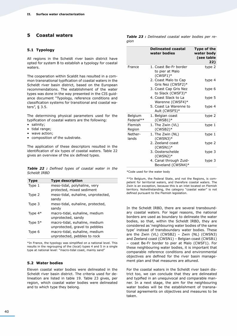
Eleven coastal water bodies were delineated in the Scheldt river basin district. The criteria used for de-lineation are listed in table 19. Table 23 gives, per region, which coastal water bodies were delineated and to which type they belong.
Table 23 : Delineated coastal water bodies per re-gion
Delineated coastal water bodies
Type of the water body
(see table 22)
France 1. Coast Be-Fr border to pier at Malo (CWSF1)*
2. Coast Malo to Cap Gris Nez (CWSF2)*
3. Coast Cap Gris Nez to Slack (CWSF3)*
4. Coast Slack to La Warenne (CWSF4)*
5. Coast La Warenne to Ault (CWSF5)*
type 2
type 4
type 6
type 5
type 4
Belgium Federal**
1. Belgian coast (CWSB1)*
type 2
Flemish Region
1. The Zwin (VL) (CWSB2)*
type 1
Nether-lands
1. The Zwin (NL) (CWSN3)*
2. Zeeland coast (CWSN1)*
3. Oosterschelde (CWSN2)*
4. Canal through Zuid-Beveland (CWSN4)*
type 1
type 2
type 3
type 3
*Code used for the water body
**In Belgium, the Federal State, and not the Regions, is com-petent for territorial waters, and therefore coastal waters. The Zwin is an exception, because this is an inlet located on Flemish territory. Notwithstanding, the category “coastal water” is not defined pursuant to the Flemish legislation.
In the Scheldt IRBD, there are several transbound-ary coastal waters. For legal reasons, the national borders are used as boundary to delineate the water bodies, so that, within the Scheldt IRBD, they are considered as ‘neighbouring water bodies of the same type’ instead of transboundary water bodies. These are the Zwin (VL) (CWSB2) – Zwin (NL) (CWSN3) and Zeeland coast (CWSN1) – Belgian coast (CWSB1) – coast Be-Fr border to pier at Malo (CWSF1). For these neighbouring water bodies, it is important that comparable reference conditions and environmental objectives are defined for the river basin manage-ment plan and that measures are attuned.
For the coastal waters in the Scheldt river basin dis-trict too, we can conclude that they are delineated and typified in an unequivocal and comparable man-ner. In a next stage, the aim for the neighbouring water bodies will be the establishment of transna-tional agreements on objectives and measures to be taken.
41
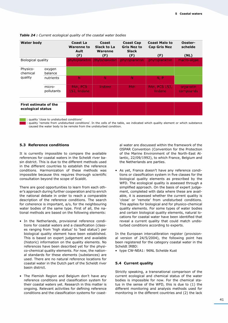
Table 24 : Current ecological quality of the coastal water bodies
Water body Coast La Warenne to
Ault (F)
Coast Slack to La Warenne
(F)
Coast Cap Gris Nez to
Slack (F)
Coast Malo to Cap Gris Nez
(F)
Ooster-schelde
(NL)Biological quality phytoplankton phytoplankton phytoplankton phytoplankton macro-algae
Physico-chemical quality
oxygen balancenutrients N N N N, P
micro-pollutants
PAH, PCB 153, lindane
lindane PAH PAH, PCB 153, lindane
organotin compounds
First estimate of the ecological status
: quality ‘close to undisturbed conditions’ : quality ‘remote from undisturbed conditions’. In the cells of the table, we indicated which quality element or which substance
caused the water body to be remote from the undisturbed condition.
5.3 Reference conditions
It is currently impossible to compare the available references for coastal waters in the Scheldt river ba-sin district. This is due to the different methods used in the different countries to establish the reference conditions. Harmonization of these methods was impossible because this requires thorough scientific consultation beyond the scope of Scaldit.
There are good opportunities to learn from each oth-er’s approach during further cooperation and to enrich the national debate in order to reach a comparable description of the reference conditions. The search for coherence is important, a/o, for the neighbouring water bodies of the same type. First of all, the na-tional methods are based on the following elements:
• In the Netherlands, provisional reference condi-tions for coastal waters and a classification (class-es ranging from ‘high status’ to ‘bad status’) per biological quality element have been established. This is based on expert judgement and available (historic) information on the quality elements. No references have been described yet for the physi-co-chemical quality elements. For now, the nation-al standards for these elements (substances) are used. There are no natural reference locations for coastal water in the Dutch part of the Scheldt river basin district.
• The Flemish Region and Belgium don’t have any reference conditions and classification system for their coastal waters yet. Research in this matter is ongoing. Relevant activities for defining reference conditions and the classification systems for coast-
al water are discussed within the framework of the OSPAR Convention (Convention for the Protection of the Marine Environment of the North-East At-lantic, 22/09/1992), to which France, Belgium and the Netherlands are parties.
• As yet, France doesn’t have any reference condi-tions or classification system in five classes for the biological quality elements as prescribed by the WFD. The ecological quality is assessed through a simplified approach. On the basis of expert judge-ment, completed with data where these are avail-able, it is assessed whether the current quality is ‘close’ or ‘remote’ from undisturbed conditions. This applies for biological and for physico-chemical quality elements. For some types of water bodies and certain biological quality elements, natural lo-cations for coastal water have been identified that reveal a current quality that could match undis-turbed conditions according to experts.
In the European intercalibration register (provision-al version of 24/5/2004), the following point has been registered for the category coastal water in the Scheldt IRBD:• type CW-NEA1: 96NL Schelde Kust
5.4 Current quality
Strictly speaking, a transnational comparison of the current ecological and chemical status of the water bodies is impossible for now. For the chemical sta-tus in the sense of the WFD, this is due to (1) the different monitoring and analysis methods used for monitoring in the different countries and (2) the lack
5 Coastal waters
42
II. Surface water characterization
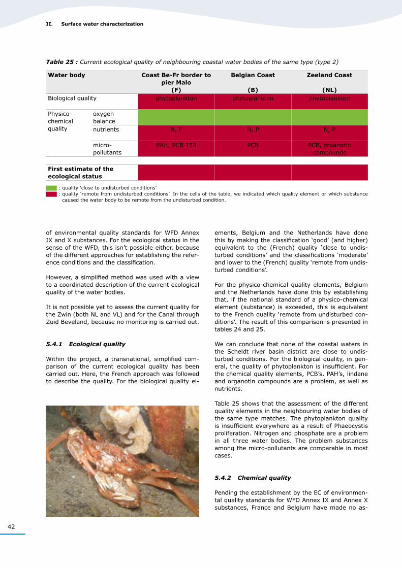
Table 25 : Current ecological quality of neighbouring coastal water bodies of the same type (type 2)
Water body Coast Be-Fr border to pier Malo
(F)
Belgian Coast
(B)
Zeeland Coast
(NL)Biological quality phytoplankton phytoplankton phytoplankton
Physico-chemical quality
oxygen balancenutrients N, P N, P N, P
micro-pollutants
PAH, PCB 153 PCB PCB, organotin compounds
First estimate of the ecological status
: quality ‘close to undisturbed conditions’ : quality ‘remote from undisturbed conditions’. In the cells of the table, we indicated which quality element or which substance
caused the water body to be remote from the undisturbed condition.
of environmental quality standards for WFD Annex IX and X substances. For the ecological status in the sense of the WFD, this isn’t possible either, because of the different approaches for establishing the refer-ence conditions and the classification.
However, a simplified method was used with a view to a coordinated description of the current ecological quality of the water bodies.
It is not possible yet to assess the current quality for the Zwin (both NL and VL) and for the Canal through Zuid Beveland, because no monitoring is carried out.
5.4.1 Ecological quality
Within the project, a transnational, simplified com-parison of the current ecological quality has been carried out. Here, the French approach was followed to describe the quality. For the biological quality el-
ements, Belgium and the Netherlands have done this by making the classification ‘good’ (and higher) equivalent to the (French) quality ‘close to undis-turbed conditions’ and the classifications ‘moderate’ and lower to the (French) quality ‘remote from undis-turbed conditions’.
For the physico-chemical quality elements, Belgium and the Netherlands have done this by establishing that, if the national standard of a physico-chemical element (substance) is exceeded, this is equivalent to the French quality ‘remote from undisturbed con-ditions’. The result of this comparison is presented in tables 24 and 25.
We can conclude that none of the coastal waters in the Scheldt river basin district are close to undis-turbed conditions. For the biological quality, in gen-eral, the quality of phytoplankton is insufficient. For the chemical quality elements, PCB’s, PAH’s, lindane and organotin compounds are a problem, as well as nutrients.
Table 25 shows that the assessment of the different quality elements in the neighbouring water bodies of the same type matches. The phytoplankton quality is insufficient everywhere as a result of Phaeocystis proliferation. Nitrogen and phosphate are a problem in all three water bodies. The problem substances among the micro-pollutants are comparable in most cases.
5.4.2 Chemical quality
Pending the establishment by the EC of environmen-tal quality standards for WFD Annex IX and Annex X substances, France and Belgium have made no as-