Embed Size (px)
Citation preview
ALPINE NVD-T334 68-00323Z53-B (EN)
EN
DE
FR
IT
ES
SE
NL
DK
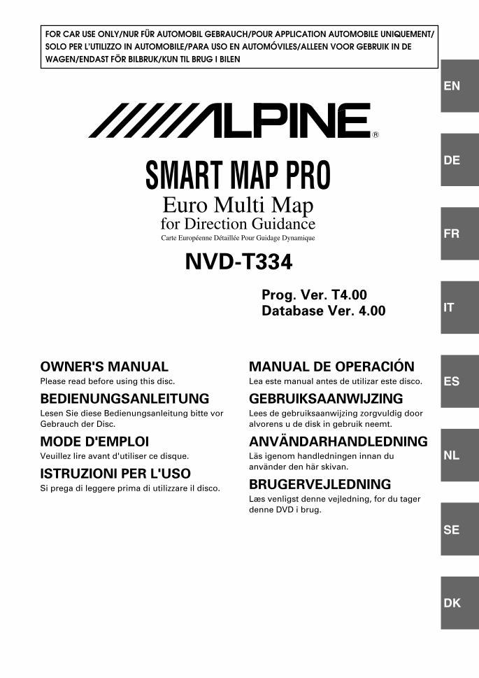
SMART MAP PROEuro Multi Mapfor Direction GuidanceCarte Européenne Détaillée Pour Guidage Dynamique
MANUAL DE OPERACIÓNLea este manual antes de utilizar este disco.
GEBRUIKSAANWIJZINGLees de gebruiksaanwijzing zorgvuldig dooralvorens u de disk in gebruik neemt.
ANVÄNDARHANDLEDNINGLäs igenom handledningen innan duanvänder den här skivan.
BRUGERVEJLEDNINGLæs venligst denne vejledning, for du tagerdenne DVD i brug.
NVD-T334
Prog. Ver. T4.00Database Ver. 4.00
R
OWNER'S MANUALPlease read before using this disc.
BEDIENUNGSANLEITUNGLesen Sie diese Bedienungsanleitung bitte vorGebrauch der Disc.
MODE D'EMPLOIVeuillez lire avant d'utiliser ce disque.
ISTRUZIONI PER L'USOSi prega di leggere prima di utilizzare il disco.
FOR CAR USE ONLY/NUR FÜR AUTOMOBIL GEBRAUCH/POUR APPLICATION AUTOMOBILE UNIQUEMENT/SOLO PER L’UTILIZZO IN AUTOMOBILE/PARA USO EN AUTOMÓVILES/ALLEEN VOOR GEBRUIK IN DEWAGEN/ENDAST FÖR BILBRUK/KUN TIL BRUG I BILEN
00_Cover_NVD-T334 05.2.1, 1:40 PM1
Black
2-EN
LLLLL The map database is designed to provide you with routesuggestions, it does not take account of the relativesafety of a suggested route, or of factors which mayaffect the time required to reach your destination. Thedatabase does not reflect road closures or construction,road characteristics (i.e. type of road surface, slope orgrade, weight or height restrictions, etc.), trafficcongestion, weather conditions, or any other factorswhich may affect the safety or timing of your drivingexperience. Use your personal judgment if thenavigation system is unable to provide you with analternate route.
LLLLL There may be situations where the navigation systemmay display the vehicle's location erroneously. Useyour own driving judgment in this situation, taking intoaccount of current driving conditions. Please be awarethat in this situation, the navigation system shouldcorrect the vehicle's position automatically; however,there may be times where you may have to correct theposition yourself. If this is the case, stop the vehicle ina safe and legal manner and location before attemptingoperation.
LLLLL Make certain that the volume level of the main unit isset to a level which still allows you to hear outsidetraffic and emergency vehicles. Driving while unable tohear outside sounds could cause an accident.
LLLLL Please make certain that any other person who intendson using the navigation system reads these precautionsand the following instructions carefully.
LLLLL If there is anything in the manual which you do notunderstand, or are uncertain about the operation of thenavigation system, please contact an authorized Alpinerepresentative before using the navigation system.
PrecautionsImportant Information, Please ReadCarefully Before Using This Product.
This product is intended to safely provide turn byturn instruction to get you to a desired destination.Please read the following precautions to ensurethat you use your navigation system correctly.
LLLLL This product is not a substitute for your personaljudgment. Any route suggestions made by thenavigation system may never supersede any local trafficregulations or your personal judgment and/orknowledge of safe driving practices. Do not followroute suggestions if the navigation system instructs youto perform an unsafe or illegal manoeuvre, places youin an unsafe situation, or routes you into an area whichyou consider unsafe.
LLLLL Glance at the screen only when necessary and safe todo so. If prolonged viewing of the screen is necessary,stop the vehicle in a safe and legal manner andlocation.
LLLLL Do not input destinations, change settings, or accessany functions requiring a prolonged view of the screenand/or remote control while you are driving. Stop thevehicle in a safe and legal manner and location beforeattempting to access the system.
LLLLL Do not use the navigation system to route you toemergency services. Not all locations of emergencyservice providers such as police and fire stations,hospitals, and clinics are contained in the database.Please use your own judgment and your ability to askfor directions in these situations.
LLLLL The map database contained within the media (DVDROM) in which it is stored is the most recent map dataavailable at the time of production. Because of changesin streets and neighbourhoods, there may be situationswhere the navigation system may not be able to routeyou to your desired destination. In these cases, use yourown personal judgment.
ENGLISH
3-EN
Points to Observe for Safe Usage
a Read the manuals for this disc and the systemcomponents carefully before using your navigationsystem. They contain instructions on how to usethe system in a safe and effective manner. Alpinecannot be responsible for problems resulting fromfailure to observe the instructions in thesemanuals.
a This manual uses various pictorial displays toshow you how to use this product safely and toalert you to potential dangers resulting fromimproper connections and operation. Followingare the meanings of these pictorial displays. It isimportant to fully understand the meanings ofthese pictorial displays in order to use this manualand the system properly.
WARNINGThis symbol means important instructions. Failureto heed them can result in serious injury or death.
DO NOT DISASSEMBLE OR ALTER.Doing so may result in an accident, fire or electric shock.
KEEP SMALL OBJECTS SUCH AS BATTERIES OUT OF THEREACH OF CHILDREN.Swallowing them may result in serious injury. If swallowed,consult a physician immediately.
DO NOT OPERATE ANY FUNCTION THAT TAKES YOURATTENTION AWAY FROM SAFELY DRIVING YOURVEHICLE.Any function that requires your prolonged attention should onlybe performed after coming to a complete stop. Always stop thevehicle in a safe location before performing these functions.Failure to do so may result in an accident.
KEEP THE VOLUME AT A LEVEL WHERE YOU CAN STILLHEAR OUTSIDE NOISE WHILE DRIVING.Failure to do so may result in an accident.
DO NOT FOLLOW ROUTE SUGGESTIONS IF THENAVIGATION SYSTEM INSTRUCTS YOU TO PERFORM ANUNSAFE OR ILLEGAL MANEUVER, OR PLACES YOU IN ANUNSAFE SITUATION OR AREA.This product is not a substitute for your personal judgment. Anyroute suggestions by this system should never supersede any localtraffic regulations or your personal judgment or knowledge ofsafe driving practice.
USE THIS PRODUCT FOR MOBILE 12V APPLICATIONS.Use for other than its designed application may result in fire,electric shock or other injury.
DO NOT PLACE HANDS, FINGERS OR FOREIGN OBJECTSIN INSERTION SLOTS OR GAPS.Doing so may result in personal injury or damage to the product.
CAUTIONThis symbol means important instructions. Failureto heed them can result in injury or materialproperty damage.
HALT USE IMMEDIATELY IF A PROBLEM APPEARS.Failure to do so may cause personal injury or damage to theproduct. Return it to your authorized Alpine dealer or the nearestAlpine Service Centre for repairing.
KEEP FINGERS AWAY WHILE THE MOTORIZED FRONTPANEL OR MOVING MONITOR IS IN MOTION.Failure to do so may result in personal injury or damage to theproduct.
TipThis indicates supplementary explanation of operationof the system.
4-EN
ALPINE NVD-T334 68-00323Z53-B (EN)
User Agreement
In using this DVD-ROM “SMART MAP PRO”(hereinafter referred to as “Disk”), as part of theAISIN AW CO., Ltd. (“AISIN AW”) and NAVTEQCorporation (“NAVTEQ”) Database (hereinafterreferred to as “Database”), you are bound by theterms and conditions set forth below. By breakingthe seal on this package, and using your copy ofthe Database and Disk, you have demonstratedyour agreement to the terms and conditions of thisAgreement. You should therefore, make sure thatyou read and understand the following provisions.
a The Disk and Database may not be copied,duplicated, processed, or otherwise modified, inwhole or in part, without the express writtenpermission of AISIN AW, NAVTEQ and ALPINEElectronics, Inc. (“ALPINE”).
a Neither the Disk nor the Database may betransferred or sublicensed to any third party forprofit, rent or loan, or licensed for reuse in anymanners.
a The Disk and/or Database may not bedecompiled, reverse engineered or otherwisedisassembled, in whole or in part.
a The Disk and Database may not be used in anetwork or by any other manner of simultaneoususe in multiple systems.
a The Disk and Database are intended solely forpersonal use (or internal use where the end-userbusiness), or the consumer. The Disk andDatabase are not to be used for commercialpurposes.
a Neither AISIN AW, ALPINE nor NAVTEQguarantees to the customer that the functionsincluded in the Disk and Database meet a specificobjective of user.
a Neither AISIN AW, ALPINE nor NAVTEQ shall beresponsible for any damages caused by the useof the Disk and/or Database to the actual userand to any third party.
a The Warranty on the Disk and Database shall notextend to an exchange or refund due tomisspelling, omission of letters, or any othercosmetic discrepancy in layout found in Disk and/or Database.
a The right to use the Disk and Database shallexpire either when the user destroys this software,or when any of the terms for use is violated andAISIN AW, ALPINE and/or NAVTEQ exercises theoption to revoke the licence to use this software.
a The terms and conditions hereof apply to allsubsequent users and owners as well as to theactual purchaser.
To Customers who use the INA-N333Ror INA-N333RR model
The Owner's Manual explains the function of thedisc for the New-Version (Prog. Ver.T4.00,Database Ver.4.00).
a Operating System Programme Rewriting1) Insert the upgrade disc into your INA-N333R or
INA-N333RR.2) The operating system will automatically be
rewritten.
WARNINGa Operation of the system while driving is
dangerous. Users should stop vehicle beforeoperating the software.
a Road conditions and regulations takeprecedence over information contained on thedisplay: observe actual traffic restrictions andcircumstances while driving.
a This software is designed for use exclusively inthe INA-N333R, INA-N333RR, INA-N333RS orINA-N333RRS. It cannot and may not be usedin conjunction with other hardware.
Precautions
01_02-09_NVD-T334(EN) 05.2.1, 1:44 PM4
Black
5-EN
PrecautionsImportant Information, Please Read
Carefully Before Using This Product. .... 2Points to Observe for Safe Usage .......... 3WARNING .................................................. 3CAUTION ................................................... 3User Agreement ....................................... 4To Customers who use the INA-N333R
or INA-N333RR model .......................... 4
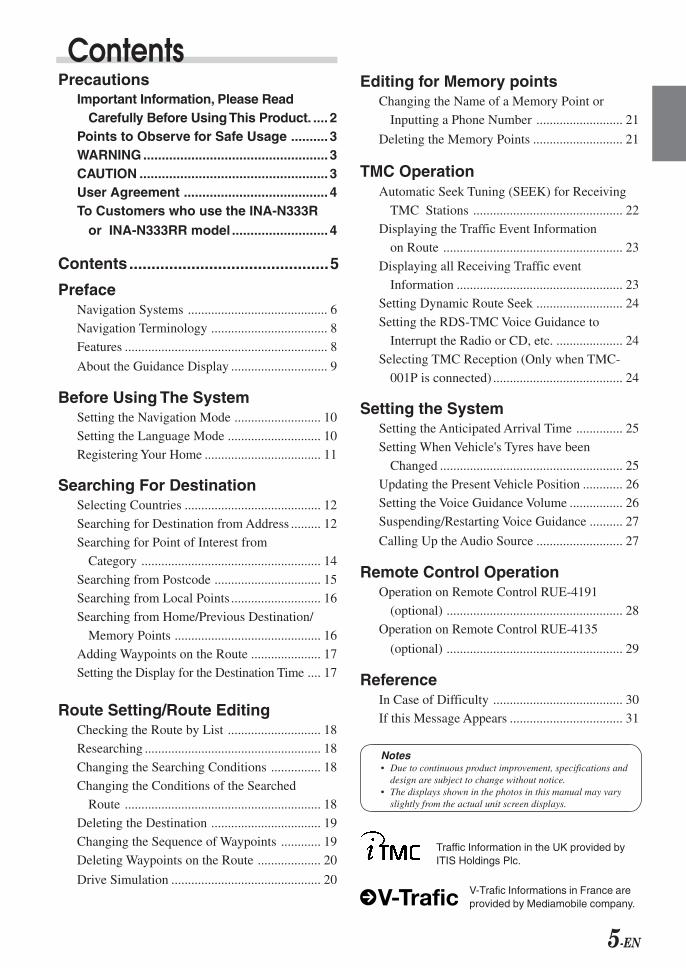
Contents.............................................5
PrefaceNavigation Systems .......................................... 6
Navigation Terminology ................................... 8
Features ............................................................. 8
About the Guidance Display ............................. 9
Before Using The SystemSetting the Navigation Mode .......................... 10
Setting the Language Mode ............................ 10
Registering Your Home ................................... 11
Searching For DestinationSelecting Countries ......................................... 12
Searching for Destination from Address ......... 12
Searching for Point of Interest from
Category ...................................................... 14
Searching from Postcode ................................ 15
Searching from Local Points ........................... 16
Searching from Home/Previous Destination/
Memory Points ............................................ 16
Adding Waypoints on the Route ..................... 17
Setting the Display for the Destination Time .... 17
Route Setting/Route EditingChecking the Route by List ............................ 18
Researching ..................................................... 18
Changing the Searching Conditions ............... 18
Changing the Conditions of the Searched
Route ........................................................... 18
Deleting the Destination ................................. 19
Changing the Sequence of Waypoints ............ 19
Deleting Waypoints on the Route ................... 20
Drive Simulation ............................................. 20
Editing for Memory pointsChanging the Name of a Memory Point or
Inputting a Phone Number .......................... 21
Deleting the Memory Points ........................... 21
TMC OperationAutomatic Seek Tuning (SEEK) for Receiving
TMC Stations ............................................. 22
Displaying the Traffic Event Information
on Route ...................................................... 23
Displaying all Receiving Traffic event
Information .................................................. 23
Setting Dynamic Route Seek .......................... 24
Setting the RDS-TMC Voice Guidance to
Interrupt the Radio or CD, etc. .................... 24
Selecting TMC Reception (Only when TMC-
001P is connected) ....................................... 24
Setting the SystemSetting the Anticipated Arrival Time .............. 25
Setting When Vehicle's Tyres have been
Changed ....................................................... 25
Updating the Present Vehicle Position ............ 26
Setting the Voice Guidance Volume ................ 26
Suspending/Restarting Voice Guidance .......... 27
Calling Up the Audio Source .......................... 27
Remote Control OperationOperation on Remote Control RUE-4191
(optional) ..................................................... 28
Operation on Remote Control RUE-4135
(optional) ..................................................... 29
ReferenceIn Case of Difficulty ....................................... 30
If this Message Appears .................................. 31
Contents
Notes• Due to continuous product improvement, specifications and
design are subject to change without notice.• The displays shown in the photos in this manual may vary
slightly from the actual unit screen displays.
Traffic Information in the UK provided byITIS Holdings Plc.
V-Trafic Informations in France areprovided by Mediamobile company.
6-EN
Navigation Systems
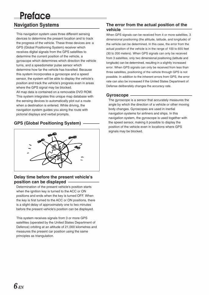
This navigation system uses three different sensingdevices to determine the present location and to trackthe progress of the vehicle. These three devices are: aGPS (Global Positioning System) receiver whichreceives digital signals from the GPS satellites todetermine the current position of the vehicle, agyroscope which determines which direction the vehicleturns, and a speedometer pulse sensor whichdetermine how far the vehicle has travelled. Becausethis system incorporates a gyroscope and a speedsensor, the system will be able to display the vehicle'sposition and track the vehicle's progress even in areaswhere the GPS signal may be blocked.All map data is contained on a removable DVD ROM.This system integrates this unique map database withthe sensing devices to automatically plot out a routewhen a destination is entered. While driving, thenavigation system guides you along the route withpictorial displays and verbal prompts.
GPS (Global Positioning System)
Delay time before the present vehicle'sposition can be displayed
Determination of the present vehicle's position startswhen the ignition key is turned to the ACC or ONpositions and ends when the key is turned OFF. Whenthe key is first turned to the ACC or ON positions, thereis a slight delay of approximately one to two minutesbefore the present vehicle's position can be displayed.
This system receives signals from 3 or more GPSsatellites (operated by the United States Department ofDefence) orbiting at an altitude of 21,000 kilometres andmeasures the present car position using the sameprinciples as triangulation.
PrefaceThe error from the actual position of thevehicleWhen GPS signals can be received from 4 or more satellites, 3
dimensional positioning (the altitude, latitude, and longitude) of
the vehicle can be determined. In this case, the error from the
actual position of the vehicle is in the range of 100 to 655 feet
(30 to 200 meters). When GPS signals can only be received
from 3 satellites, only two dimensional positioning (latitude and
longitude) can be determined, resulting in a slightly increased
error. When GPS signals can only be received from less than
three satellites, positioning of the vehicle through GPS is not
possible. In addition to the inherent errors from GPS, the error
rate can also be increased if the United States Department of
Defense deliberately changes the accuracy rate.
GyroscopeThe gyroscope is a sensor that accurately measures theangle by which the direction of a vehicle or other movingbody changes. Gyroscopes are used in inertialnavigation systems for airliners and ships. In thisnavigation system, the gyroscope is used together withthe speed sensor, making it possible to display theposition of the vehicle even in locations where GPSsignals may be blocked.
7-EN
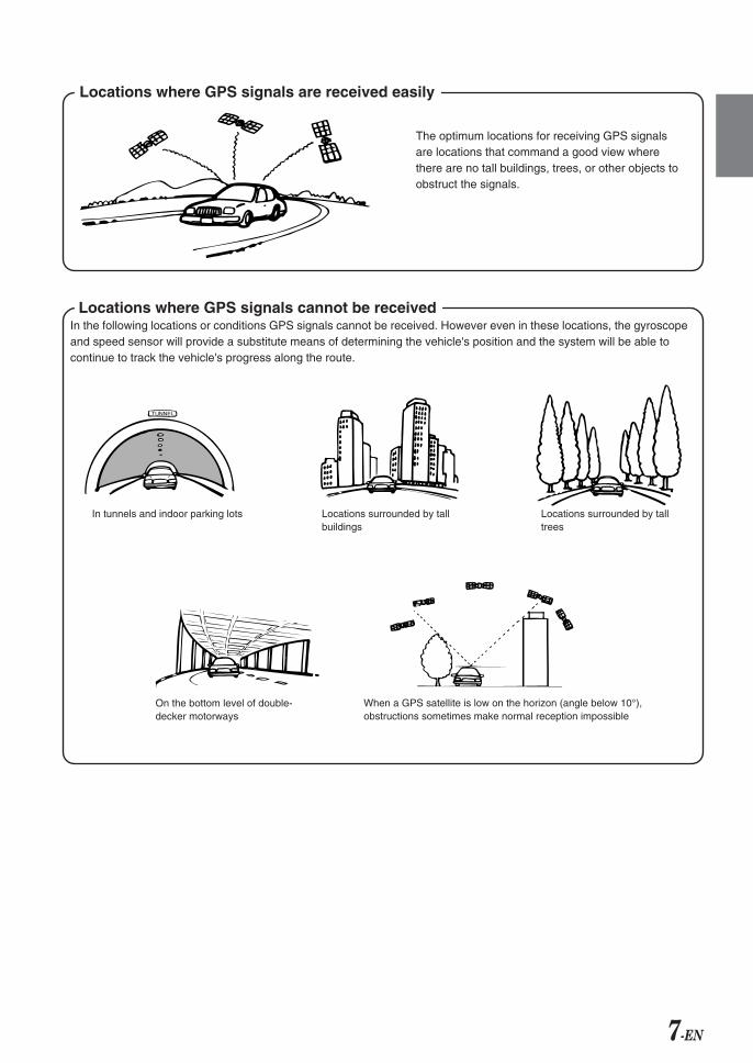
Locations where GPS signals are received easily
Locations where GPS signals cannot be receivedIn the following locations or conditions GPS signals cannot be received. However even in these locations, the gyroscopeand speed sensor will provide a substitute means of determining the vehicle's position and the system will be able tocontinue to track the vehicle's progress along the route.
The optimum locations for receiving GPS signalsare locations that command a good view wherethere are no tall buildings, trees, or other objects toobstruct the signals.
In tunnels and indoor parking lots Locations surrounded by tallbuildings
Locations surrounded by talltrees
On the bottom level of double-decker motorways
When a GPS satellite is low on the horizon (angle below 10°),obstructions sometimes make normal reception impossible
8-EN
Navigation Terminology
NavigationWhen a destination is input, the navigation systemquickly calculates a route and guides you along theroute with arrow displays and voice prompts.
Present Vehicle PositionThe navigation system integrates the GPS (GlobalPositioning System) signals received and the mapinformation stored on the DVD ROM to display theposition and direction of the vehicle. The system alsoincludes a gyroscope and a speed sensor that enable itto display the present position even in locations wherethe GPS signals may be blocked.
Map MatchingSince GPS navigation has an error of 100 – 655 feet(30 m – 200 m), the position of your vehicle may bedisplayed off the road. Map matching automaticallycorrects this error so that the position of your vehicle isdisplayed on the road.
RouteWhen a destination is input, the navigation systemautomatically calculates a route.
Road Preference SettingYou can set your preferred road on the route to thedestination for up to 2 places.
Memory PointsLocations you go to frequently can be stored intomemory. The system can store up to 50 points,excluding your home.
Motorway-Preference SelectionWhen searching for routes with the navigation system,you can switch between searching for routes that givepriority to motorways and those that give priority toordinary roads. When you specify motorway preference,the navigation system automatically searches for a routethat gives priority to motorways and guides you alongthat route.
Features
Advanced Real Junction ViewWhen you are driving on a motorway where quickdecisions are required, you can display a detailed mapof the next junction in advance, and a 3-D view of theappropriate lane along the recommended route.
PrefaceIntersection Zoom
As you near intersections and cross points, the mapdisplay automatically zooms in to show a more detailedview that you will need.
Motorway Information DisplayWhen you travel on motorways, the basic guidancedisplay (with an arrow) automatically shows thedistances to the next fuel station/restaurant/parking/junction (except exit).
Three Types of Auto Route SearchingSimultaneously
You can choose the best route from three types of routesearching to your destination.
Turn List on the RouteAfter you have set the route, you can check thesequence of waypoints, road names and distancesbetween points by displaying this list.
Setting WaypointsYou can set one or 2 waypoints to go through to yourdestination.
Real Time Voice GuidanceVoice guidance informs you of the distance and directionuntil your course changes, giving advice timed to matchroad conditions.The VOICE button lets you call up the voice guide whenneeded by just pushing the button.
DVD-ROM covers All European AreasAll areas of Europe are covered by one disc.
Eight Languages selectable for the Voiceand Display Guidance
You can choose one of eight languages for the voiceroute guidance and menu displays. (see the “Setting theLanguage Mode” section, page 10.)
Built-in Gyroscope and Speed SensorsThe gyroscope for sensing direction and the speedpulse sensor for detecting distance provide data whichallows the vehicle position and direction to be displayedeven in locations where the GPS signal cannot bereceived such as between buildings or in tunnels.
TMC (Traffic Message Channel)If there is TMC information, TMC stations can bereceived by selecting a station on the built-in TMC tuner.The optional RDS-TMC receiver box TMC-001P canalso be connected.
9-EN
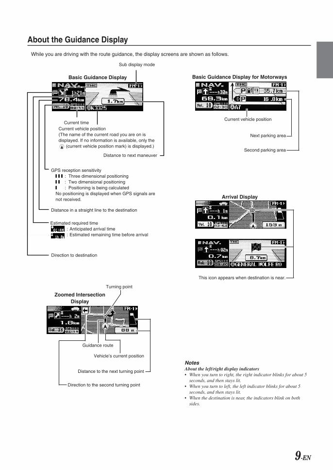
About the Guidance Display
While you are driving with the route guidance, the display screens are shown as follows.
NotesAbout the left/right display indicators• When you turn to right, the right indicator blinks for about 5
seconds, and then stays lit.• When you turn to left, the left indicator blinks for about 5
seconds, and then stays lit.• When the destination is near, the indicators blink on both
sides.
Basic Guidance Display for Motorways
Second parking area
Next parking area
Current vehicle position
Arrival Display
This icon appears when destination is near.
Sub display mode
Estimated required time: Anticipated arrival time: Estimated remaining time before arrival
Direction to destination
Distance in a straight line to the destination
Current timeCurrent vehicle position(The name of the current road you are on isdisplayed. If no information is available, only the
(current vehicle position mark) is displayed.)
Distance to next maneuver
GPS reception sensitivity77777 77777 77777 : Three dimensional positioning77777 77777 : Two dimensional positioning77777 : Positioning is being calculatedNo positioning is displayed when GPS signals arenot received.
Basic Guidance Display
Zoomed IntersectionDisplay
Guidance route
Turning point
Vehicle’s current position
Distance to the next turning point
Direction to the second turning point
10-EN
Before Using The System
Setting the Navigation Mode
1 Press SOURCE/POWER button to turn on the power.
2 Press the NAV. button.Changing the Audio mode to Navigation mode.The current vehicle position is displayed.
3 Press c button to open the display and then insert theSMART MAP PRO disc.
4 Move the Flipper switch up or down to move thecursor to the desired language and press the OKbutton or MODE knob to execute the selection. (Whenthe system is used for the first time)
NoteFor English, you can select the distance indications in eithermiles (mile) or Kilometres (km).For other languages, only kilometres are used for the distanceindications.
5 Selected language is displayed.An important message is displayed. Please read thismessage after stopping the vehicle in a safe location.Press the OK button. (You cannot carry out thisoperation with the Enter button on the optional remotecontrol.)
6 The present vehicle position is displayed.
NoteSome operations (when displaying the navigation menu, etc.)cannot be performed while the vehicle is in motion. In this case,be sure to first stop your vehicle and apply the parking brake,then perform the operation.
Setting the Language Mode
For the picture/voice guidance and texts, you canchoose one of 8 languages as follows.
a German (Deutsch) a Dutch (Nederlands)
a English (mile or km) a Spanish (Español)
a French (Français) a Swedish (Svensk)
a Italian (Italiano) a Danish (Dansk)
The guidance language can be changed whenever youlike by following the procedure below.
1 Press the MENU button to display “NAV. MENU.”
2 Select “Navigation Setup” from “NAV. MENU” bymoving the Flipper switch up or down and press theOK button or MODE knob to execute the selection.
3 Select “System Setup” from “Navigation Setup” bymoving the Flipper switch up or down.Press the OK button or MODE knob to execute theselection.
4 Select “Language” from “System Setup” by moving theFlipper switch up or down.Press the OK button or MODE knob to execute theselection.
NAV. OK MODE
Flipper switchMENU RTN
SOURCE/POWER
c
Number of received satellite signals
11-EN
8 The screen switches to the “Edit Memory Point” menu.Move the Flipper switch up or down to select“Register Home.”Press the OK button or MODE knob to execute theselection.
9 The message is displayed.Select “Yes” by the Flipper switch and press the OKbutton or MODE knob to execute the selection.Your home is registered.
10 To return to the previous screen, press the RTN button,or to return to the “NAV. MENU” screen, press theMENU button.
5 Select the desired language from the “Language” listby moving the Flipper switch up or down and pressthe OK button or MODE knob to execute the selection.
NoteFor English, you can select the distance indications in eithermiles or Kilometres (km).For other languages, only kilometres are used for the distanceindications.
6 The selected language is displayed.An important message is displayed. Please read thismessage after stopping the vehicle in a safe location.Press the OK button. (You cannot carry out thisoperation with the Enter button on the optional remotecontrol.)
NoteYou cannot use the MENU button while the vehicle is in motion.Stop your vehicle in a safe place before using the MENU button.
Registering Your Home
If home has already been registered, you can call it upwith a simple operation.
1 Park your vehicle near your home where GPS signalreception is good.
2 Start your vehicle engine and set to navigation mode,then wait about 5 minutes to receive clear GPS signals.
3 Press the OK button.The message appears. Select “Yes” by the Flipperswitch and press the OK button or MODE knob toexecute the selection.
4 Press the MENU button to display “NAV. MENU.”
5 Select “Navigation Setup” from “NAV. MENU” bymoving the Flipper switch up or down.Press the OK button or MODE knob to execute theselection.
6 Select “Memory Points” from “Navigation Setup” bymoving the Flipper switch up or down and press theOK button or MODE knob to execute the selection.
7 The screen changes and the address stored in step 3is displayed.Press the OK button or the MODE knob to set theaddress.

12-EN
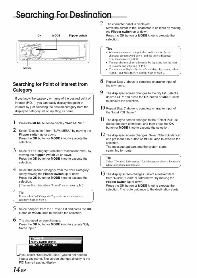
Searching For Destination
Selecting Countries
When you search for destinations or points of interest inother countries from their addresses or categories,choose the desired country first by following theprocedure below.
1 Press the MENU button to display “NAV. MENU.”
2 Select “Destination” from “NAV. MENU” by moving theFlipper switch up or down.Press the OK button or MODE knob to execute theselection.
3 Select “Country” from the “Destination” menu bymoving the Flipper switch up or down and press theOK button or MODE knob to execute the selection.
4 Select the desired country from the “Select Country”list by moving the Flipper switch up or down.Press the OK button or MODE knob to execute theselection.For example, if you wish to go to London, select“United Kingdom.”
Tip You can select your desired locations in 20 countries.
5 The display returns to the “Destination” menu.The search for selected country has now beenactivated.
6 To return to the previous screen, press the RTN button,or to return to the “NAV. MENU” screen, press theMENU button.
Searching for Destination fromAddress
If you know the address of the destination, you candisplay its location by just inputting the address (nameof the city/street).
1 Press the MENU button to display “NAV. MENU.”
2 Select “Destination” from “NAV. MENU” by moving theFlipper switch up or down.Press the OK button or MODE knob to execute theselection.
3 Select “Address” from “Destination” by moving theFlipper switch up or down.Press the OK button or MODE knob to execute theselection.
4 Press the OK button or MODE knob to execute “CityName Input.”
OK MODE Flipper switch
MENU RTN

13-EN
10 The screen changes to the “Option” screen.Select “Set” and press the OK button or MODE knob toexecute the selection.
2nd Street:If you know an intersection near where you want to go,you can input two cross streets as your destination.The character pallet is displayed. Input a cross streetname.
House Number: use to input a house number.The character pallet is displayed. Input a housenumber.
11 The displayed screen changes.Select “Start Guidance” and press the OK button orMODE knob to execute the selection.
Add Way Point:Use to add waypoints (see the “Adding Waypoints onthe Route,” page 17).
Detailed Information:Use this menu for address, phone numberinformation, etc., when a location is searched forusing POI Category.If there is no data for address, longitude and latitudeare displayed.
Register to Memory Points:Use to register the location. When the confirmationmessage is displayed, select “Yes” and press the OKbutton to execute the selection.
12 The message appears and route search starts.
13 The displayed screen changes.Move the cursor to the selected item by moving theFlipper switch up or down and press the OK button orMODE knob to execute the setting of the item.The route guidance to the destination starts.
Quick: The shortest time route.Short: The shortest distance route.Alternative:Use to search for an alternative route.
5 The character pallet is displayed.Move the cursor to the character to be input by movingthe Flipper switch up or down.Press the OK button or MODE knob to execute thecharacter.
a : Text windowDisplays the selected characters.
b : List of the candidate number
c : LISTDisplays a list of the candidate names for theselected characters.
d : Character palletSelect the desired character.
e : Return to the previous character pallet beforeinputting one character.Return to the previous character and erase it.
Tips• When one character is input, the candidates for the next
character are narrowed down (and the others disappearfrom the character pallet).
• You can also search for a location by inputting just the startof its name and selecting “LIST.”
• If you want to display the list of candidate city names,select “LIST,” and then press OK button. Skip to Step 7.
6 Repeat Step 5 above to complete the character inputfor the city name.
7 The screen changes to the “Select City” list screen.Select a desired city and press the OK button orMODE knob to execute the selection.
8 Repeat Step 5 above to complete character input ofthe street name.
9 The screen changes to the “Select Street” list screen.Select a desired street and press the OK button orMODE knob to execute the selection.
a
d
c
b
e
14-EN
Searching For Destination
Searching for Point of Interest fromCategory
If you know the category or name of the desired point ofinterest (P.O.I.), you can easily display that point ofinterest by just selecting the desired category from thedisplayed category list or inputting its name.
1 Press the MENU button to display “NAV. MENU.”
2 Select “Destination” from “NAV. MENU” by moving theFlipper switch up or down.Press the OK button or MODE knob to execute theselection.
3 Select “POI Category” from the “Destination” menu bymoving the Flipper switch up or down.Press the OK button or MODE knob to execute theselection.
4 Select the desired category from the “POI Category”list by moving the Flipper switch up or down.Press the OK button or MODE knob to execute theselection.(This section describes “Travel” as an example.)
TipIf you select “All Categories”, you do not need to selectcategory. Skip to Step 6.
5 Select “Airport” from the “Travel” list and press the OKbutton or MODE knob to execute the selection.
6 The displayed screen changes.Press the OK button or MODE knob to execute “CityName Input.”
If you select “Search All Cities,” you do not need toinput a city name. The screen changes directly to thePOI Name inputting display.
7 The character pallet is displayed.Move the cursor to the character to be input by movingthe Flipper switch up or down.Press the OK button or MODE knob to execute theselection.
Tips• When one character is input, the candidates for the next
character are narrowed down (and the others disappearfrom the character pallet).
• You can also search for a location by inputting just the startof its name and selecting “LIST.”
• If you want to display the list of candidate city names, select“LIST” and press the OK button. Skip to Step 9.
8 Repeat Step 7 above to complete character input ofthe city name.
9 The displayed screen changes to the city list. Select adesired CITY and press the OK button or MODE knobto execute the selection.
10 Repeat Step 7 above to complete character input ofthe “Input POI Name.”
11 The displayed screen changes to the “Select POI” list.Select the point of interest, and then press the OKbutton or MODE knob to execute the selection.
12 The displayed screen changes. Select “Start Guidance”and press the OK button or MODE knob to execute theselection.The message appears and the system startssearching for route.
TipSelect “Detailed Information” for information about a location'saddress or phone number, etc.
13 The display screen changes. Select a desired itemfrom “Quick”, “Short” or “Alternative” by moving theFlipper switch up or down.Press the OK button or MODE knob to execute theselection. The route guidance to the destination starts.
OK MODE Flipper switch
MENU
15-EN
Searching from Postcode
If you know the postcode of the destination, you candisplay its location by just inputting the postcode and streetname.
1 Press the MENU button to display “NAV. MENU.”
2 Select “Destination” from “NAV. MENU” by moving theFlipper switch up or down.Press the OK button or MODE knob to execute theselection.
3 Select “Post cord” from the “Destination” by moving theFlipper switch up or down.Press the OK button or MODE knob to execute theselection.
4 The character pallet is displayed.Move the cursor to the character to be input by movingthe Flipper switch up or down.Press the OK button or MODE knob to execute thecharacter.
Tips• When one character is input, the next available characters
are narrowed down (the others disappear from the characterpallet).
• You can also search for a location by inputting just the startof its name and selecting “LIST.”
• If you want to display the list of candidate city names,select “LIST,” and then press OK button. Skip to Step 6.
5 Repeat Step 4 above to complete the character inputfor the postcode.
6 The screen changes to the “Select Postcode” listscreen. Select a desired postcode and press the OKbutton or MODE knob to execute the selection.
7 Repeat Step 4 above to complete character input ofthe street name.
8 The screen changes to the “Select Street” list screen.Select a desired street and press the OK button orMODE knob to execute the selection.
9 The screen changes to the “Option” screen. Select“Set” and press the OK button or MODE knob toexecute the selection.
10 The displayed screen changes. Select “Start Guidance”and press the OK button or MODE knob to execute theselection.The message appears and the system starts searchingfor route.
11 The display screen changes. Select a desired itemfrom “Quick”, “Short” or “Alternative” by moving theFlipper switch up or down.Press the OK button or MODE knob to execute theselection. The route guidance to the destination starts.
16-EN
Searching For Destination
Searching from Local Points
You can search for POIs such as restaurants, hotels, etc.,within a 30 km radius of the present vehicle position.
1 Press the MENU button to display “NAV. MENU.”
2 Select “Destination” from “NAV. MENU” by moving theFlipper switch up or down and press the OK button orMODE knob to execute the selection.
3 Select “Local POI” from the “Destination” menu bymoving the Flipper switch up or down.Press the OK button or MODE knob to execute theselection.
4 Select a desired category from the “Local POI” list andpress the OK button or MODE knob to execute theselection.This section describes the procedure using“Restaurant” as an example.
5 Select “Chinese” from the “Restaurant” list and pressthe OK button or MODE knob to execute the selection.The message appears and the system starts searchingfor POI within a 30 km radius of the vehicle.
6 The “Select Local POI” list is displayed. Select adesired local point and press the OK button or MODEknob to execute the selection.
7 The displayed screen changes. Select “Start Guidance”and press the OK button or MODE knob to execute theselection.The message appears and the system starts searchingfor the route.
8 The displayed screen changes. Select a desired itemfrom “Quick/Short/Alternative” by moving the Flipperswitch up or down, and then press the OK button orMODE knob to execute the selection.
Searching from Home/PreviousDestination/Memory Points
1 Press the MENU button to display “NAV. MENU.”
2 Select “Destination” from “NAV. MENU” by moving theFlipper switch up or down and press the OK button orMODE knob to execute the selection.
3 Select “Home” from the “Destination” menu by movingthe Flipper switch up or down and press the OKbutton or MODE knob to execute the selection.This section describes “Searching from home” as anexample.
4 The displayed screen changes. Select “Start Guidance”and press the OK button or MODE knob to execute theselection.The message appears and the system starts searchingfor the route.
5 The displayed screen changes. Select a desired itemfrom “Quick/Short/Alternative” by moving the Flipperswitch up or down.Press the OK button or MODE knob to execute theselection.The route guidance back to your home starts.
OK MODE Flipper switch
MENU RTN
17-EN
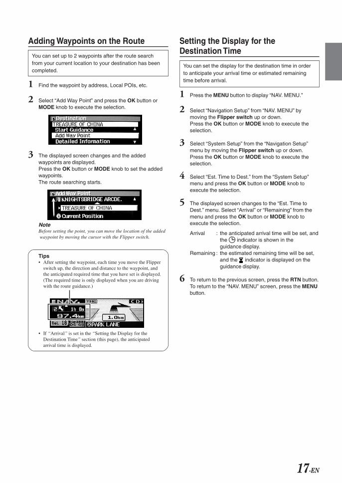
Adding Waypoints on the Route
You can set up to 2 waypoints after the route searchfrom your current location to your destination has beencompleted.
1 Find the waypoint by address, Local POIs, etc.
2 Select “Add Way Point” and press the OK button orMODE knob to execute the selection.
3 The displayed screen changes and the addedwaypoints are displayed.Press the OK button or MODE knob to set the addedwaypoints.The route searching starts.
NoteBefore setting the point, you can move the location of the added waypoint by moving the cursor with the Flipper switch.
Tips• After setting the waypoint, each time you move the Flipper
switch up, the direction and distance to the waypoint, andthe anticipated required time that you have set is displayed.(The required time is only displayed when you are drivingwith the route guidance.)
Setting the Display for theDestination Time
You can set the display for the destination time in orderto anticipate your arrival time or estimated remainingtime before arrival.
1 Press the MENU button to display “NAV. MENU.”
2 Select “Navigation Setup” from “NAV. MENU” bymoving the Flipper switch up or down.Press the OK button or MODE knob to execute theselection.
3 Select “System Setup” from the “Navigation Setup”menu by moving the Flipper switch up or down.Press the OK button or MODE knob to execute theselection.
4 Select “Est. Time to Dest.” from the “System Setup”menu and press the OK button or MODE knob toexecute the selection.
5 The displayed screen changes to the “Est. Time toDest.” menu. Select “Arrival” or “Remaining” from themenu and press the OK button or MODE knob toexecute the selection.
Arrival : the anticipated arrival time will be set, andthe indicator is shown in theguidance display.
Remaining : the estimated remaining time will be set,and the indicator is displayed on theguidance display.
6 To return to the previous screen, press the RTN button.To return to the “NAV. MENU” screen, press the MENUbutton.
• If “Arrival” is set in the “Setting the Display for theDestination Time” section (this page), the anticipatedarrival time is displayed.
18-EN
Route Setting/Route Editing
Checking the Route by List
With this detailed list you can find the route, road nameand the distance between the points.
1 After setting the route, press the MENU button todisplay “NAV. MENU.”
2 Select “Edit Route” from “NAV. MENU” by moving theFlipper switch up or down.Press the OK button or MODE knob to execute theselection.
3 Select “Turn List” from the “Edit Route” menu bymoving the Flipper switch up or down.Press the OK button or MODE knob to execute the selection.
4 The route information is displayed.The “Turn List” scrolls by moving the Flipper switch up.
5 To return to the previous screen, press the RTN button.To return to the “NAV. MENU” screen, press the MENUbutton.
Researching
You can edit the route search conditions even after theroute calculation has been performed, and have thesystem search for alternative route.
1 Press the MENU button to display “NAV. MENU.”
2 Select “Edit Route” from “NAV. MENU” by moving theFlipper switch up or down.Press the OK button or MODE knob to execute theselection.
3 Select “Re-route” from the “Edit Route” menu bymoving the Flipper switch up or down.Press the OK button or MODE knob to execute theselection.
4 The system starts to search for a new round-aboutroute in the vicinity of the vehicle.
Changing the Searching Conditions
Use this when you want to change the route preferencewhile you are driving receiving route guidance. (Forexample, if the route preference is set to “Quick”, andyou want to change to another route preference.)
1 Press the MENU button to display “NAV. MENU.”
2 Select “Edit Route” from “NAV. MENU” by moving theFlipper switch up or down.Press the OK button or MODE knob to execute theselection.
3 Select “Search Condition” from the “Edit Route” menuby moving the Flipper switch up or down.Press the OK button or MODE knob to execute theselection.
4 Set your preference (Quick, Short, Alternative) from the“Search Condition” menu.
Changing the Conditions of theSearched Route
You can edit the route to use the motorway, ferry, etc. ornot.
1 Press the MENU button to display “NAV. MENU.”
2 Select “Edit Route” from “NAV. MENU” by moving theFlipper switch up or down.Press the OK button or MODE knob to execute theselection.
3 Select “Route Preference” from the “Edit Route” menuby moving the Flipper switch up or down.Press the OK button or MODE knob to execute theselection.
4 Move the cursor to your desired editing item from the“Route Preference” menu by moving the Flipperswitch up or down.Press the OK button or MODE knob to execute thesetting of the item.
5 The displayed screen changes. Select “Allow” or“Detour” and press the OK button or MODE knob toexecute the selection.
6 To return to the previous screen, press the RTN button.To return to the “NAV. MENU” screen, press the MENUbutton.
NoteThe “Motorway Allow” setting is recommended when searchingfor a long distance route.
OK MODE Flipper switch
MENU RTN
19-EN
Deleting the Destination
When the address in the vicinity of the destination isdisplayed after arrival at the destination, the pointinformation is erased automatically. If the route guidance iscancelled before arrival at the destination or if the addressin the vicinity of the destination is not displayed, the pointinformation remains. In such a case, delete the destination.
1 Press the MENU button to display “NAV. MENU.”
2 Select “Edit Route” from “NAV. MENU” by moving theFlipper switch up or down.Press the OK button or MODE knob to execute theselection.
3 Select “Delete Destination” from the “Edit Route” menuby moving the Flipper switch up or down.Press the OK button or MODE knob to execute theselection.
4 When the message appears, select “Yes” and press theOK button or MODE knob to execute the selection.
The destination is erased and the display returns to thepresent vehicle position.
TipIf you slide the Flipper switch down after setting thedestination, the above message appears. Select “Yes” andpress the OK button or MODE knob to delete the destinationyou have set.
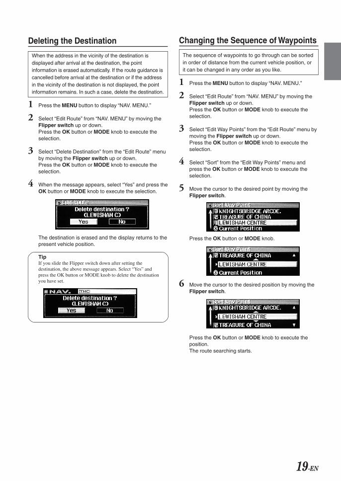
Changing the Sequence of Waypoints
The sequence of waypoints to go through can be sortedin order of distance from the current vehicle position, orit can be changed in any order as you like.
1 Press the MENU button to display “NAV. MENU.”
2 Select “Edit Route” from “NAV. MENU” by moving theFlipper switch up or down.Press the OK button or MODE knob to execute theselection.
3 Select “Edit Way Points” from the “Edit Route” menu bymoving the Flipper switch up or down.Press the OK button or MODE knob to execute theselection.
4 Select “Sort” from the “Edit Way Points” menu andpress the OK button or MODE knob to execute theselection.
5 Move the cursor to the desired point by moving theFlipper switch.
Press the OK button or MODE knob.
6 Move the cursor to the desired position by moving theFlipper switch.
Press the OK button or MODE knob to execute theposition.The route searching starts.
20-EN
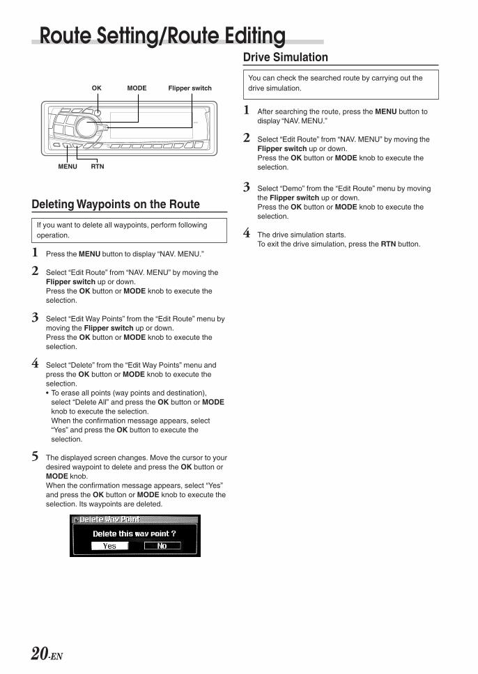
Route Setting/Route Editing
Deleting Waypoints on the Route
If you want to delete all waypoints, perform followingoperation.
1 Press the MENU button to display “NAV. MENU.”
2 Select “Edit Route” from “NAV. MENU” by moving theFlipper switch up or down.Press the OK button or MODE knob to execute theselection.
3 Select “Edit Way Points” from the “Edit Route” menu bymoving the Flipper switch up or down.Press the OK button or MODE knob to execute theselection.
4 Select “Delete” from the “Edit Way Points” menu andpress the OK button or MODE knob to execute theselection.• To erase all points (way points and destination),
select “Delete All” and press the OK button or MODEknob to execute the selection.When the confirmation message appears, select“Yes” and press the OK button to execute theselection.
5 The displayed screen changes. Move the cursor to yourdesired waypoint to delete and press the OK button orMODE knob.When the confirmation message appears, select “Yes”and press the OK button or MODE knob to execute theselection. Its waypoints are deleted.
Drive Simulation
You can check the searched route by carrying out thedrive simulation.
1 After searching the route, press the MENU button todisplay “NAV. MENU.”
2 Select “Edit Route” from “NAV. MENU” by moving theFlipper switch up or down.Press the OK button or MODE knob to execute theselection.
3 Select “Demo” from the “Edit Route” menu by movingthe Flipper switch up or down.Press the OK button or MODE knob to execute theselection.
4 The drive simulation starts.To exit the drive simulation, press the RTN button.
OK MODE Flipper switch
MENU RTN
21-EN
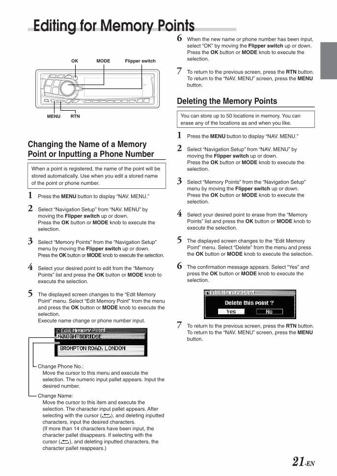
6 When the new name or phone number has been input,select “OK” by moving the Flipper switch up or down.Press the OK button or MODE knob to execute theselection.
7 To return to the previous screen, press the RTN button.To return to the “NAV. MENU” screen, press the MENUbutton.
Deleting the Memory Points
You can store up to 50 locations in memory. You canerase any of the locations as and when you like.
1 Press the MENU button to display “NAV. MENU.”
2 Select “Navigation Setup” from “NAV. MENU” bymoving the Flipper switch up or down.Press the OK button or MODE knob to execute theselection.
3 Select “Memory Points” from the “Navigation Setup”menu by moving the Flipper switch up or down.Press the OK button or MODE knob to execute theselection.
4 Select your desired point to erase from the “MemoryPoints” list and press the OK button or MODE knob toexecute the selection.
5 The displayed screen changes to the “Edit MemoryPoint” menu. Select “Delete” from the menu and pressthe OK button or MODE knob to execute the selection.
6 The confirmation message appears. Select “Yes” andpress the OK button or MODE knob to execute theselection.
7 To return to the previous screen, press the RTN button.To return to the “NAV. MENU” screen, press the MENUbutton.
Editing for Memory Points
Changing the Name of a MemoryPoint or Inputting a Phone Number
When a point is registered, the name of the point will bestored automatically. Use when you edit a stored nameof the point or phone number.
1 Press the MENU button to display “NAV. MENU.”
2 Select “Navigation Setup” from “NAV. MENU” bymoving the Flipper switch up or down.Press the OK button or MODE knob to execute theselection.
3 Select “Memory Points” from the “Navigation Setup”menu by moving the Flipper switch up or down.Press the OK button or MODE knob to execute the selection.
4 Select your desired point to edit from the “MemoryPoints” list and press the OK button or MODE knob toexecute the selection.
5 The displayed screen changes to the “Edit MemoryPoint” menu. Select “Edit Memory Point” from the menuand press the OK button or MODE knob to execute theselection.Execute name change or phone number input.
Change Phone No.:Move the cursor to this menu and execute theselection. The numeric input pallet appears. Input thedesired number.
Change Name:Move the cursor to this item and execute theselection. The character input pallet appears. Afterselecting with the cursor ( ), and deleting inputtedcharacters, input the desired characters.(If more than 14 characters have been input, thecharacter pallet disappears. If selecting with thecursor ( ), and deleting inputted characters, thecharacter pallet reappears.)
OK MODE Flipper switch
MENU RTN
22-EN
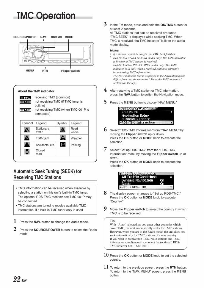
Legend
Stationarytraffic
Traffic jam
Accidents, etc.
Closedroad
Symbol Legend
Roadworks
Weather
Parking
Symbol
About the TMC indicator
: receiving TMC (common): not receiving TMC (if TMC tuner is
built-in): not receiving TMC (when TMC-001P is
connected)
TMC Operation
OK/TMC MODE
Flipper switchMENU RTN
Automatic Seek Tuning (SEEK) forReceiving TMC Stations
• TMC information can be received when available byselecting a station on this unit's built-in TMC tuner.The optional RDS-TMC receiver box TMC-001P maybe connected.
• TMC stations are tuned to receive available TMCinformation, if a built-in TMC tuner only is used.
1 Press the NAV. button to change the Audio mode.
2 Press the SOURCE/POWER button to select the Radiomode.
3 In the FM mode, press and hold the OK/TMC button forat least 2 seconds.All TMC stations that can be received are tuned.“TMC SEEK” is displayed while seeking TMC. WhenTMC is received, the TMC indicator∗ is lit on the audiomode display.
Notes• If a station cannot be sought, the TMC Seek finishes.∗ INA-N333R or INA-N333RR model only: The TMC indicator
is lit when a TMC station is received.INA-N333RS or INA-N333RRS model only: The TMCindicator is lit only when a received station is currentlybroadcasting TMC information.The TMC indicator that is displayed in the Navigation modediffers from that shown in the “About the TMC indicator”section (on the left).
4 After receiving a TMC station or TMC information,press the NAV. button to switch the Navigation mode.
5 Press the MENU button to display “NAV. MENU.”
6 Select “RDS-TMC Information” from “NAV. MENU” bymoving the Flipper switch up or down.Press the OK button or MODE knob to execute theselection.
7 Select “Set up RDS-TMC” from the “RDS-TMCInformation” menu by moving the Flipper switch up ordown.Press the OK button or MODE knob to execute theselection.
8 The display screen changes to “Set up RDS-TMC.”Press the OK button or MODE knob to execute“Country.”
9 Move the Flipper switch to select the country in whichTMC is to be received.
TipWith “Auto” selected, as you enter other countries whichcover TMC, the unit automatically seeks for TMC stations.However, when you are in the Radio mode, the unit does notseek automatically for TMC stations of a new country.If you wish to receive non-TMC radio stations and TMCinformation simultaneously, connect the (optional) RDS-TMC receiver box, TMC-001P.
10 Press the OK button or MODE knob to set the selectedcountry.
11 To return to the previous screen, press the RTN button.To return to the “NAV. MENU” screen, press the MENUbutton.
SOURCE/POWER NAV.
23-EN
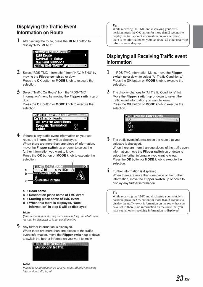
Displaying the Traffic EventInformation on Route
1 After setting the route, press the MENU button todisplay “NAV. MENU.”
2 Select “RDS-TMC Information” from “NAV. MENU” bymoving the Flipper switch up or down.Press the OK button or MODE knob to execute theselection.
3 Select “Traffic On Route” from the “RDS-TMCInformation” menu by moving the Flipper switch up ordown.Press the OK button or MODE knob to execute theselection.
4 If there is any traffic event information on your setroute, the information will be displayed.When there are more than one piece of information,move the Flipper switch up or down to select thefurther information you want to know.Press the OK button or MODE knob to execute theselection.
a : Road nameb : Destination place name of TMC eventc : Starting place name of TMC eventd : When this mark is displayed, “Detail
Information” in step 5 will be displayed.
NoteIf the destination or starting place name is long, the whole namemay not be displayed. It is not a malfunction.
5 Any further information is displayed.When there are more than one pieces of the trafficevent information, move the Flipper switch up or downto switch the further information you want to know.
NoteIf there is no information on your set route, all other receivinginformation is displayed.
TipWhile receiving the TMC and displaying your car’sposition, press the OK button for more than 2 seconds todisplay the traffic event information on your set route. Ifthere is no information on your set route, all other receivinginformation is displayed.
Displaying all Receiving Traffic eventInformation
1 In RDS-TMC Information Menu, move the Flipperswitch up or down to select “All Traffic Conditions.”Press the OK button or MODE knob to execute theselection.
2 The display changes to “All Traffic Conditions” list.Move the Flipper switch up or down to select thetraffic event information you want to know.Press the OK button or MODE knob to execute theselection.
3 The traffic event information on the route that youselected is displayed.When there are more than one pieces of the traffic eventinformation, move the Flipper switch up or down toselect the further information you want to know.Press the OK button or MODE knob to execute theselection.
4 Further information is displayed.When there are more than one piece of the furtherinformation, move the Flipper switch up or down todisplay any further information.
TipWhile receiving the TMC and displaying your vehicle’sposition, press the OK button for more than 2 seconds todisplay the traffic event information on the route that youhave set. If there is no information on the route that youhave set, all other receiving information is displayed.
c
d
ba
24-EN
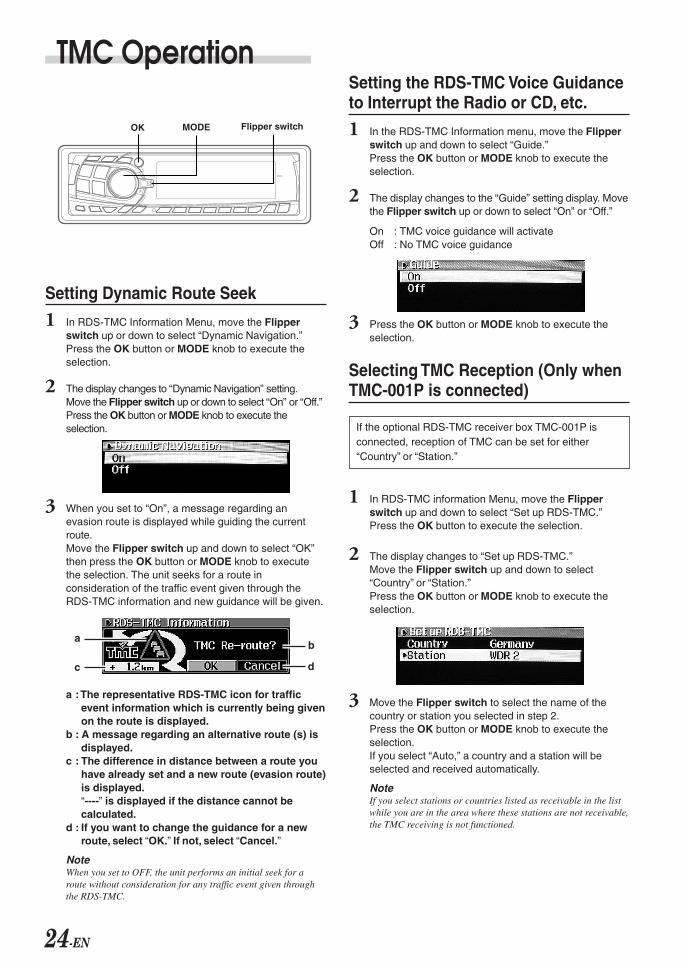
Setting Dynamic Route Seek
1 In RDS-TMC Information Menu, move the Flipperswitch up or down to select “Dynamic Navigation.”Press the OK button or MODE knob to execute theselection.
2 The display changes to “Dynamic Navigation” setting.Move the Flipper switch up or down to select “On” or “Off.”Press the OK button or MODE knob to execute theselection.
3 When you set to “On”, a message regarding anevasion route is displayed while guiding the currentroute.Move the Flipper switch up and down to select “OK”then press the OK button or MODE knob to executethe selection. The unit seeks for a route inconsideration of the traffic event given through theRDS-TMC information and new guidance will be given.
a : The representative RDS-TMC icon for trafficevent information which is currently being givenon the route is displayed.
b : A message regarding an alternative route (s) isdisplayed.
c : The difference in distance between a route youhave already set and a new route (evasion route)is displayed.“----” is displayed if the distance cannot becalculated.
d : If you want to change the guidance for a newroute, select “OK.” If not, select “Cancel.”
NoteWhen you set to OFF, the unit performs an initial seek for aroute without consideration for any traffic event given throughthe RDS-TMC.
Setting the RDS-TMC Voice Guidanceto Interrupt the Radio or CD, etc.
1 In the RDS-TMC Information menu, move the Flipperswitch up and down to select “Guide.”Press the OK button or MODE knob to execute theselection.
2 The display changes to the “Guide” setting display. Movethe Flipper switch up or down to select “On” or “Off.”
On : TMC voice guidance will activateOff : No TMC voice guidance
3 Press the OK button or MODE knob to execute theselection.
Selecting TMC Reception (Only whenTMC-001P is connected)
1 In RDS-TMC information Menu, move the Flipperswitch up and down to select “Set up RDS-TMC.”Press the OK button to execute the selection.
2 The display changes to “Set up RDS-TMC.”Move the Flipper switch up and down to select“Country” or “Station.”Press the OK button or MODE knob to execute theselection.
3 Move the Flipper switch to select the name of thecountry or station you selected in step 2.Press the OK button or MODE knob to execute theselection.If you select “Auto,” a country and a station will beselected and received automatically.
NoteIf you select stations or countries listed as receivable in the listwhile you are in the area where these stations are not receivable,the TMC receiving is not functioned.
If the optional RDS-TMC receiver box TMC-001P isconnected, reception of TMC can be set for either“Country” or “Station.”
TMC Operation
OK MODE Flipper switch
a
c
b
d
25-EN
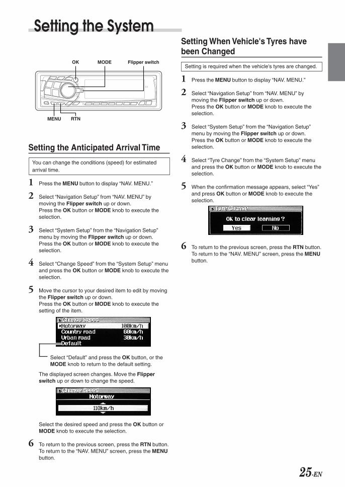
Setting the System
Setting the Anticipated Arrival Time
You can change the conditions (speed) for estimatedarrival time.
1 Press the MENU button to display “NAV. MENU.”
2 Select “Navigation Setup” from “NAV. MENU” bymoving the Flipper switch up or down.Press the OK button or MODE knob to execute theselection.
3 Select “System Setup” from the “Navigation Setup”menu by moving the Flipper switch up or down.Press the OK button or MODE knob to execute theselection.
4 Select “Change Speed” from the “System Setup” menuand press the OK button or MODE knob to execute theselection.
5 Move the cursor to your desired item to edit by movingthe Flipper switch up or down.Press the OK button or MODE knob to execute thesetting of the item.
Select “Default” and press the OK button, or theMODE knob to return to the default setting.
The displayed screen changes. Move the Flipperswitch up or down to change the speed.
Select the desired speed and press the OK button orMODE knob to execute the selection.
6 To return to the previous screen, press the RTN button.To return to the “NAV. MENU” screen, press the MENUbutton.
Setting When Vehicle's Tyres havebeen Changed
Setting is required when the vehicle's tyres are changed.
1 Press the MENU button to display “NAV. MENU.”
2 Select “Navigation Setup” from “NAV. MENU” bymoving the Flipper switch up or down.Press the OK button or MODE knob to execute theselection.
3 Select “System Setup” from the “Navigation Setup”menu by moving the Flipper switch up or down.Press the OK button or MODE knob to execute theselection.
4 Select “Tyre Change” from the “System Setup” menuand press the OK button or MODE knob to execute theselection.
5 When the confirmation message appears, select “Yes”and press OK button or MODE knob to execute theselection.
6 To return to the previous screen, press the RTN button.To return to the “NAV. MENU” screen, press the MENUbutton.
OK MODE Flipper switch
MENU RTN
26-EN
Setting the SystemSetting the Voice Guidance Volume
When the voice guidance of the navigation systemstarts, the volume level of any currently playing audiosource is reduced automatically. You can also adjust thevolume level of voice guidance.
To set the volume level of voice guidance
1 Press and hold the F/SETUP button for at least 2seconds. The display changes to the SETUP screen.
2 Move the Flipper switch up or down to select NAVIMIX.Press the OK button or MODE knob to set.
3 Move the Flipper switch up or down to select ON orOFF.Press the OK button or MODE knob to set. The displayreturns to the SETUP screen.
4 Press the F/SETUP button to change to the Navigationmode.
5 When displaying the present vehicle position or voiceguidance, press the MODE (Audio control) knobrepeatedly to select the NAVI MIX mode.
6 Turn the MODE (Audio control) knob until the desiredsound is obtained.
Notes• If you don't hear the voice guidance, press the VOICE button
to repeat the voice guidance.• If you have an external audio processor, you can listen to
voice guidance with the extension speaker (KAX-551N).
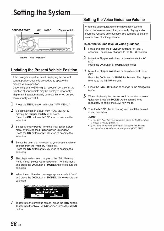
Updating the Present Vehicle Position
If the navigation system is not displaying the correctcurrent position, use this procedure to update thepresent vehicle position.Depending on the GPS signal reception conditions, thedirection of your vehicle may be displayed incorrectly.Map matching automatically corrects this error, but youcan manually correct it.
1 Press the MENU button to display “NAV. MENU.”
2 Select “Navigation Setup” from “NAV. MENU” bymoving the Flipper switch up or down.Press the OK button or MODE knob to execute theselection.
3 Select “Memory Points” from the “Navigation Setup”menu by moving the Flipper switch up or down.Press the OK button or MODE knob to execute theselection.
4 Select the point that is closest to your present vehicleposition from the “Memory Points” list.Press the OK button or MODE knob to execute theselection.
5 The displayed screen changes to the “Edit MemoryPoint” menu. Select “Current Position” from the menuand press the OK button or MODE knob to execute theselection.
6 When the confirmation message appears, select “Yes”and press the OK button or MODE knob to execute theselection.
7 To return to the previous screen, press the RTN button.To return to the “NAV. MENU” screen, press the MENUbutton.
OK MODE Flipper switch
MENU
SOURCE/POWER
F/SETUPRTN
27-EN
Calling Up the Audio Source
1 While in the Navigation mode (except NAV. MENUscreen and each list screen), you can change over to anaudio source by pressing the SOURCE/POWER button.In addition, you can perform operations such as callingup a preset, switching BAND and TRACK UP/DOWN,SETUP, bass engine, etc.For Audio operation, refer to the INA-N333R/INA-N333RR or INA-N333RS/INA-N333RRS of Owner’sManual.
Main Display Mode: current mode is displayed.
Sub Display Mode: each time you switch thesource, the display mode switches.
Audio Source Volume: Displays audio sourcevolume, or during Voice Guidance interruption,automatically switches to display VoiceGuidance volume.
NoteWhile the navigation menu is displayed, some operations do notfunction.
TipWhen you are driving with route guidance, the voice and routeguidance can be interrupted at any time by pressing the NAV.button when you switch to the audio mode.However, when the list screen (SETUP, bass engine, etc.) isdisplayed, only the voice guidance can interrupt the audiosource.
Suspending/Restarting VoiceGuidance
1 To suspend the voice guidance, press the MENUbutton to display the “NAV. MENU” screen after theroute has been calculated.
2 Select “Suspend Guidance” from “NAV. MENU” bymoving the Flipper switch up or down.Press the OK button or MODE knob to execute theselection.The message appears and the voice guidance issuspended.
3 When you want to resume the voice guidance, pressthe MENU button. Select “Resume Guidance” from“NAV. MENU” and press the OK button or MODE knobto execute the selection.The message appears and the voice guidance isresumed.
28-EN
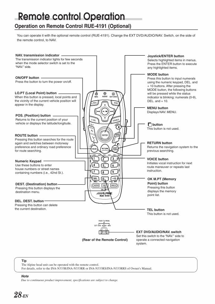
Remote control Operation
TipThe Alpine head unit can be operated with the remote control.For details, refer to the INA-N333R/INA-N333RR or INA-N333RS/INA-N333RRS of Owner's Manual.
NoteDue to continuous product improvement, specifications are subject to change.
Operation on Remote Control RUE-4191 (Optional)
You can operate it with the optional remote control (RUE-4191). Change the EXT DVD/AUDIO/NAV. Switch, on the side ofthe remote control, to NAV.
NAV. transmission indicatorThe transmission indicator lights for few secondswhen the mode selector switch is set to the“NAV.” side.
Joystick/ENTER buttonSelects highlighted items in menus.Press the ENTER button to executeany highlighted items.
MODE buttonPress this button to input numeralsusing the numeric keypad, DEL. and+ 10 buttons. After pressing theMODE button, the following buttonswill be pressed while the statusindicator is blinking: numerals (0-9),DEL. and + 10.
buttonThis button is not used.
VOICE buttonInitiates vocal instruction for nextroute maneuver or repeats lastinstruction.
OK M.PT (MemoryPoint) buttonPressing this buttondisplays the memorypoint list.
ON/OFF buttonPress the button to turn the power on/off.
DEL. DEST. buttonPressing this button can deletethe current destination.
LO.PT (Local Point) buttonWhen this button is pressed, local points andthe vicinity of the current vehicle position willappear in the display.
RETURN buttonReturns the navigation system to theprevious searching.
ROUTE buttonPressing this button searches for the routeagain and switches between motorwaypreference and ordinary road preferencefor route searching.
TEL buttonThis button is not used.
POS. (Position) buttonReturns to the current position of yourvehicle or displays the latitude/longitude.
DEST. (Destination) buttonPressing this button displays thedestination menu.
Numeric KeypadUse these buttons to enterhouse numbers or street namescontaining numbers (i.e., 42nd St.).
MENU buttonDisplays NAV. MENU.
EXT DVD/AUDIO/NAV. switchSet this switch to the “NAV.” side tooperate a connected navigationsystem.
(Rear of the Remote Control)
29-EN
Tips• The Alpine head unit can be operated with the remote control.
For details, refer to the INA-N333R/INA-N333RR or INA-N333RS/INA-N333RRS of Owner's Manual.• After pressing the MODE button, press the following buttons while the status indicator is blinking : numerals (0 to 9), BS, and OK.
NoteDue to continuous product improvement, specifications are subject to change.
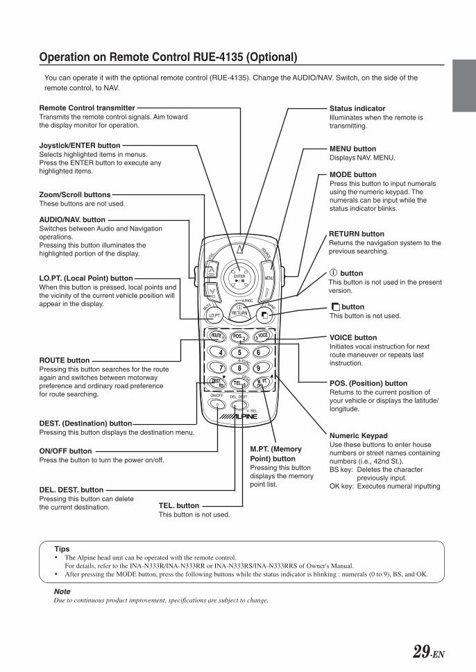
Operation on Remote Control RUE-4135 (Optional)
You can operate it with the optional remote control (RUE-4135). Change the AUDIO/NAV. Switch, on the side of theremote control, to NAV.
ENTER/
LO.PT. RETURN
54
1
BS
7 8
0
9
6
2 3
ON/OFF DEL. DEST.
OKDEST.
ROUTE VOICE
M. PT.
POS.
TEL.
V. SEL.
FUNC.
OP/CL
A.PROC.
MUTE BAND
VOL.
SOURCE
MENU
i
Remote Control transmitterTransmits the remote control signals. Aim towardthe display monitor for operation.
Status indicatorIlluminates when the remote istransmitting.
MODE buttonPress this button to input numeralsusing the numeric keypad. Thenumerals can be input while thestatus indicator blinks.
MENU buttonDisplays NAV. MENU.
buttonThis button is not used.
VOICE buttonInitiates vocal instruction for nextroute maneuver or repeats lastinstruction.
Numeric KeypadUse these buttons to enter housenumbers or street names containingnumbers (i.e., 42nd St.).BS key: Deletes the character
previously input.OK key: Executes numeral inputting
M.PT. (MemoryPoint) buttonPressing this buttondisplays the memorypoint list.
Joystick/ENTER buttonSelects highlighted items in menus.Press the ENTER button to execute anyhighlighted items.
Zoom/Scroll buttonsThese buttons are not used.
AUDIO/NAV. buttonSwitches between Audio and Navigationoperations.Pressing this button illuminates thehighlighted portion of the display.
ON/OFF buttonPress the button to turn the power on/off.
DEL. DEST. buttonPressing this button can deletethe current destination.
LO.PT. (Local Point) buttonWhen this button is pressed, local points andthe vicinity of the current vehicle position willappear in the display.
RETURN buttonReturns the navigation system to theprevious searching.
ROUTE buttonPressing this button searches for the routeagain and switches between motorwaypreference and ordinary road preferencefor route searching.
DEST. (Destination) buttonPressing this button displays the destination menu.
TEL. buttonThis button is not used.
i buttonThis button is not used in the presentversion.
POS. (Position) buttonReturns to the current position ofyour vehicle or displays the latitude/longitude.
30-EN
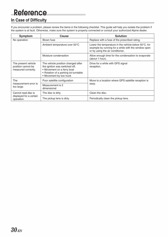
ReferenceIn Case of Difficulty
If you encounter a problem, please review the items in the following checklist. This guide will help you isolate the problem ifthe system is at fault. Otherwise, make sure the system is properly connected or consult your authorized Alpine dealer.
CauseBlown fuse
Ambient temperature over 50°C
Moisture condensation
The vehicle position changed afterthe ignition was switched off.• Movement on a ferry boat• Rotation of a parking lot turntable• Movement by tow truck
Poor satellite configuration
Measurement is 2dimensional
The disc is dirty.
The pickup lens is dirty.
SolutionReplace with a fuse of the prescribed rating.
Lower the temperature in the vehicle below 50°C, forexample by running for a while with the window openor by using the air conditioner.
Allow enough time for the condensation to evaporate(about 1 hour).
Drive for a while with GPS signalreception.
Move to a location where GPS satellite reception iseasy.
Clean the disc.
Periodically clean the pickup lens.
SymptomNo operation
The present vehicleposition cannot bemeasured correctly.
Themeasurement error istoo large.
Cannot read disc isdisplayed for a certainoperation.
31-EN
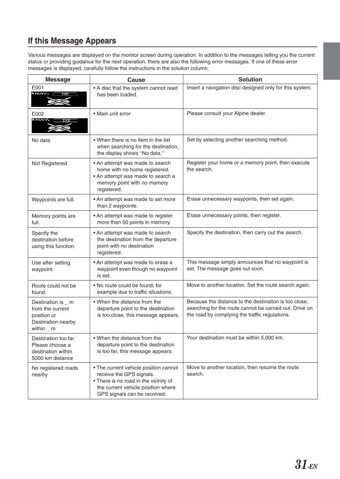
If this Message Appears
Various messages are displayed on the monitor screen during operation. In addition to the messages telling you the currentstatus or providing guidance for the next operation, there are also the following error messages. If one of these errormessages is displayed, carefully follow the instructions in the solution column.
Cause• A disc that the system cannot read
has been loaded.
• Main unit error
• When there is no item in the listwhen searching for the destination,the display shows “No data.”
• An attempt was made to searchhome with no home registered.
• An attempt was made to search amemory point with no memoryregistered.
• An attempt was made to set morethan 2 waypoints.
• An attempt was made to registermore than 50 points in memory.
• An attempt was made to searchthe destination from the departurepoint with no destinationregistered.
• An attempt was made to erase awaypoint even though no waypointis set.
• No route could be found, forexample due to traffic situations.
• When the distance from thedeparture point to the destinationis too close, this message appears.
• When the distance from thedeparture point to the destinationis too far, this message appears.
• The current vehicle position cannotreceive the GPS signals.
• There is no road in the vicinity ofthe current vehicle position whereGPS signals can be received.
SolutionInsert a navigation disc designed only for this system.
Please consult your Alpine dealer.
Set by selecting another searching method.
Register your home or a memory point, then executethe search.
Erase unnecessary waypoints, then set again.
Erase unnecessary points, then register.
Specify the destination, then carry out the search.
This message simply announces that no waypoint isset. The message goes out soon.
Move to another location. Set the route search again.
Because the distance to the destination is too close,searching for the route cannot be carried out. Drive onthe road by complying the traffic regulations.
Your destination must be within 5,000 km.
Move to another location, then resume the routesearch.
MessageE001
E002
No data
Not Registered
Waypoints are full.
Memory points arefull.
Specify thedestination beforeusing this function.
Use after settingwaypoint.
Route could not befound.
Destination is _ mfrom the currentposition orDestination nearbywithin _ m
Destination too far.Please choose adestination within5000 km distance
No registered roadsnearby
ALPINE NVD-T334 68-00323Z53-B (EN)
Yamagata Printing Co., Ltd.2-6-34, Takashima,Nishi-ku, Yokohama,Kanagawa, Japan
R
ALPINE ELECTRONICS MARKETING, INC. 1-1-8 Nishi Gotanda,
Shinagawa-ku, Tokyo 141-0031, JapanPhone 03-5496-8231
ALPINE ELECTRONICS OF AMERICA, INC.19145 Gramercy Place, Torrance,
California 90501, U.S.A.Phone 1-800-ALPINE-1 (1-800-257-4631)
1-888-NAV-HELP (1-888-628-4357)
ALPINE ELECTRONICS OF CANADA, INC. 777 Supertest Road, Toronto,
Ontario M3J 2M9, CanadaPhone 1-800-ALPINE-1 (1-800-257-4631)
1-888-NAV-HELP (1-888-628-4357)
ALPINE ELECTRONICS OF AUSTRALIA PTY. LTD.161-165 Princes Highway, Hallam
Victoria 3803, AustraliaPhone 03-8787-1200
ALPINE ELECTRONICS GmbHFrankfurter Ring 117,
80807 München, GermanyPhone 089-32 42 640
ALPINE ELECTRONICS OF U.K. LTD.Alpine House
Fletchamstead Highway,Coventry CV4 9TW, U.K.Phone 0870-33 33 763
ALPINE ELECTRONICS FRANCE S.A.R.L.(RCS PONTOISE B 338 101 280)
98, Rue de la Belle Etoile, Z.I. Paris Nord Il,B.P. 50016, 95945 Roissy Charles de Gaulle Cedex, France
Phone 01-48638989
ALPINE ITALIA S.p.A.Viale C. Colombo 8, 20090 Trezzano
Sul Naviglio (MI), ItalyPhone 02-484781
ALPINE ELECTRONICS DE ESPAÑA, S.A.Portal de Gamarra 36, Pabellón, 32
01013 Vitoria (Alava)-APDO 133, SpainPhone 945-283588
ALPINE ELECTRONICS (BENELUX) GmbHLeuvensesteenweg 510-B6,
1930 Zaventem, BelgiumPhone 02-725 13 15
© 2004 NAVTEQ All Rights Reserved.© 2005 Zenrin Europe B.V., All Rights Reserved.
Designed by ALPINE JapanPrinted in Japan (Y)
68-00323Z53-B
00_Cover_NVD-T334 05.2.1, 1:40 PM2
Black

![High-performance milling cutter NX-NVD - FRAISA SA milling cutter NX-NVD [ 2 ] The NX-NVD high-performance milling cutter with patented double groove ... 20 4 120 0.110 30.0 8.0 1910](https://img.dokumen.tips/doc/110x75/5aab05447f8b9aa06a8b6ee0/high-performance-milling-cutter-nx-nvd-fraisa-sa-milling-cutter-nx-nvd-2-the.jpg)