Embed Size (px)
Citation preview
5
EMERGENCY PREPAREDNESS AND RESPONSE WHITE PAPER
Prepared for consideration by the Delta Stewardship Council
November 8, 2010
Not reviewed by or approved by the Delta Stewardship Council
Send comments to [email protected]. All comments received are posted to the Delta Stewardship Council web site:
http://www.deltacouncil.ca.gov/
Agenda Item 9 Attachment 1

Agenda Item 9 Attachment 1
NOVEMBER 8, 2010 NOT REVIEWED OR APPROVED BY DELTA STEWARDSHIP COUNCIL ES-1
Executive Summary
Although the frequency of levee failures in the Sacramento–San Joaquin Delta (Delta) has decreased over the last 50 years, the risk of failure remains a growing concern in light of increased national attention on emergency preparedness and response to natural disasters and terrorist threats as well as the relatively recent “sunny-day” Jones Tract levee failure in the Delta. These levee failures can and do place human life and property in danger while also having potentially significant implications to the state’s water supply and the health of the Delta ecosystem.
To effectively and reliably reduce risks to people, property, and state interests in the Delta, a multi-faceted strategy of coordinated emergency preparedness, appropriate land use planning, and prioritized investment in flood protection infrastructure is necessary and prudent. Although investment in flood protection infrastructure can considerably reduce the likelihood of a catastrophic levee failure, failures are inevitable and will require the immediate implementation of a well-coordinated and carefully developed emergency response plan. To reduce response time while optimizing the effectiveness of the response effort, such a plan will need to harness the unique capabilities of each agency with a mission in the Delta.
Numerous recent studies, including those conducted by the California Emergency Management Agency (Cal EMA) have concluded there is a strong, compelling need to coordinate emergency preparedness and response planning for the Delta. Although numerous emergency planning activities have been initiated, significant potential exists for these individual activities to become redundant, misaligned, incomplete, or outdated without aggressive coordination. Conversely, the potential benefit of developing a strategic framework for Delta emergency response and recovery activities could dramatically improve the timeliness and efficiency for all of the agencies involved in these activities in the Delta. A coordinated strategy would allow for the member agencies to participate in a set of streamlined pre-planned procedures designed to reduce emergency response and recovery times.
Unfortunately, a multi-jurisdictional emergency response plan does not yet exist. Each agency with a potential role in emergency response and recovery in the Delta has a separate plan. In some cases, these plans are specific to the Delta and are considerate of its special physical characteristics and logistical challenges. However, in many other cases, these plans are general and tailored to an agency’s emergency management authority and standard operating procedures rather than how it would respond to a particular disaster in a specific region or location.
Ideally, an emergency management plan would address all four phases of emergency management: preparedness, response, recovery, and mitigation. At a minimum, such a plan must contain the immediate actions necessary to avoid the loss of life and minimize the effects of the disaster on private property and public infrastructure (i.e., response phase). Additionally, the plan should also prioritize the efforts necessary to restore necessary life-support systems to the affected area as well as determine how or if the damaged area should be restored to its pre-disaster condition (i.e., recovery phase).
Agenda Item 9 Attachment 1
EXECUTIVE SUMMARY EMERGENCY MANAGEMENT WHITE PAPER
NOVEMBER 8, 2010 ES-2 NOT REVIEWED OR APPROVED BY DELTA STEWARDSHIP COUNCIL
The development of a multi-jurisdictional emergency response plan is currently underway as a result of Senate Bill (SB) 27. This legislation established the Sacramento–San Joaquin Delta Multi-Hazard Coordination Task Force (Task Force), to be led by the Office of Emergency Services (now Cal EMA) and to include the Delta Protection Commission, California Department of Water Resource (DWR), and a representative of each of the five Delta counties. The Task Force was established to:
1. Make recommendations to the Office of Emergency Services relating to the creation of an interagency unified command system organizational framework in accordance with the guidelines of the National Incident Management System and the Standardized Emergency Management System;
2. Coordinate the development of a draft emergency preparedness and response strategy for the Delta region for submission to the Director of the Office of Emergency Services utilizing existing interagency plans and planning processes of the involved agencies; and
3. Develop and conduct an all-hazards emergency response exercise in the Delta, designed to test regional coordination protocols already in place.
Although emergency preparedness and response for levee failures and flooding in the Delta is receiving increased attention and is improving, broader and more intense coordination is required to ensure that existing efforts can be seamlessly integrated into a specific unified command structure as required under SB 27, the Sacramento-San Joaquin Delta Emergency Preparedness Act of 2008.
A central feature of the interagency unified command structure that the Task Force is expected to propose (Cal EMA, 2010b) is a Multi Agency Coordination System (MACS). This feature is to provide a mechanism for allocating scarce resources to competing demands in the context of the emergency. It depends on a predefined priority system to be applied through consensus, involving all jurisdictions and agencies that either use or provide these resources within the affected area. The key to Task Force success is whether this can produce an effective overall response strategy for whatever complex Delta emergency occurs.
The risk of a single or multiple simultaneous levee failures in the Delta is increasing, and more needs to be done to improve the number of islands eligible for federal assistance under current Hazard Mitigation Program (HMP) criteria. HMP criteria are used by the Federal Emergency Management Agency (FEMA) to determine eligibility for disaster assistance to repair damaged levees. Failure of Delta islands to meet the HMP criteria could result in the loss of hundreds of millions or billions of dollars of federal assistance for recovery from a major levee emergency caused by either a flood or an earthquake.
The federal and California state governments have responded in several ways to the need for emergency preparedness and response planning in the Delta. The importance of effective leadership and coordination of the activities of these agencies in the event of an emergency cannot be overstated. On the local level, each county in the Delta has established an Office of Emergency Services, a central authority for coordinating emergency operations activities in a defined area; however, of all Delta counties, only San Joaquin County has developed an evacuation plan that identifies specific responsibilities and procedures that would be used during emergencies. Cal EMA and the United State Army Corps of Engineers have agreed to assist other counties in developing their own plans, for which San Joaquin County’s plan could be used as a template.
Adequate funding for necessary planning, levee maintenance, and investment in future repairs is needed. At this time, in the event of an emergency, many reclamation districts in the Delta protected by non-project levees cannot count on receiving disaster assistance from FEMA, nor can they afford the cost of improving levees to the standard required to qualify for this assistance.
Agenda Item 9 Attachment 1
EMERGENCY MANAGEMENT WHITE PAPER EXECUTIVE SUMMARY
NOVEMBER 8, 2010 NOT REVIEWED OR APPROVED BY DELTA STEWARDSHIP COUNCIL ES-3
The state interests in the Delta include the coequal goals of water supply reliability and protection of the Delta ecosystem, and, inherently, protection of the Delta as an evolving place. When considering the risk of floods and other possible emergencies in the Delta, it is important that preparation and response strategies consider not only risks to human life as a first priority, but also consider the implications to water supply, ecosystem health, and the future of the Delta as a place. Currently, no integrated, substantive strategy for Delta emergency preparedness and response addresses all of these state interests. In particular, knowledge of the potential effects of levee breaches on the ecosystem is limited at best, and an appropriate and effective response and rehabilitation strategy to help recover a damaged ecosystem have not been defined.
Agenda Item 9 Attachment 1

Agenda Item 9 Attachment 1
NOVEMBER 8, 2010 NOT REVIEWED OR APPROVED BY DELTA STEWARDSHIP COUNCIL iii
Contents Section Page Executive Summary ................................................................................................................................ ES-1
Section 1 Introduction ................................................................................................................................ 1-1 Purpose and Use ............................................................................................................................ 1-2 Statutory Requirements ................................................................................................................. 1-2
Section 2 Background ................................................................................................................................ 2-1 Phases of Emergency Management .............................................................................................. 2-1
Preparation .................................................................................................................... 2-1 Response ....................................................................................................................... 2-2 Recovery ....................................................................................................................... 2-2 Mitigation ..................................................................................................................... 2-2
History of Delta Levee Failures and Response ............................................................................. 2-2 Emergency Response Authority and Responsibilities .................................................................. 2-3
Local (Counties and Reclamation Districts) ................................................................. 2-3 State (California Emergency Management Agency and California Department of Water Resources) ..................................................................................................... 2-4 Federal (Federal Emergency Management Agency and United States Army Corps of Engineers) ...................................................................................................... 2-5
Section 3 Current Status of Emergency Management in the Delta ............................................................ 3-1 Delta Multi-Hazard Coordination Planning (Senate Bill 27) ........................................................ 3-2 Local Emergency Preparedness and Response ............................................................................. 3-4 Regional Emergency Preparedness and Response ........................................................................ 3-8
Delta Protection Commission ....................................................................................... 3-8 Department of Water Resources ................................................................................... 3-9 United States Army Corps of Engineers ..................................................................... 3-10
Island and Tract Eligibility for Disaster Assistance .................................................................... 3-10 Project Levees............................................................................................................. 3-10 Non-project Levees ..................................................................................................... 3-12
Section 4 References .................................................................................................................................. 4-1
Figures 3-1 Contingency Map, Bacon Island ................................................................................................... 3-5 3-2 Joint Flood Flight Commands ....................................................................................................... 3-7 3-3 State-Federal Project Levees in the Delta ................................................................................... 3-11 3-4 Delta Levee Criteria and Standards Based on Levee Geometry ................................................. 3-13 3-5 Non-project Local Levees in the Delta ....................................................................................... 3-14
Agenda Item 9 Attachment 1

Agenda Item 9 Attachment 1
NOVEMBER 8, 2010 NOT REVIEWED OR APPROVED BY DELTA STEWARDSHIP COUNCIL 1-1
Section 1 Introduction
The Sacramento–San Joaquin Delta and Suisun Marsh, collectively referred to as the Delta, together comprise the largest estuary in the western hemisphere of the Americas. This region simultaneously serves a number of roles, all of which are integral to the essence and sustainability of California and its economy. The Delta is home to numerous plant and animal species, some of which are found nowhere else in the world. The region serves as the hub of California’s water supply system and as a thoroughfare for key transportation corridors and electrical, gas, and communication lines. The region is important to recreation and tourism, and its rich soils support a highly productive agricultural industry.
An extensive patchwork of levees delineates the waterways and islands that define the Delta. Approximately 1,115 miles of levees protect 700,000 acres of lowland in the Delta. In Suisun Marsh, approximately 230 miles of levees protect over 50,000 acres of marsh land. Unfortunately, these levees are constantly threatened by earthquakes, floods, subsidence, sea-level change, and other factors that could cause a catastrophic levee failure. Levee failures, and the associated inundation, can cause loss of life, destruction of property and infrastructure, interruption of water supply, crop loss, environmental damage, interruption of commercial navigation, and other similar statewide economic effects.
Although investment in levees can considerably reduce the likelihood of a catastrophic failure, failures are inevitable and require the implementation of a well-coordinated and carefully developed emergency response plan. At a minimum, such plans contain the immediate actions necessary to avoid the loss of life and minimize the effects of the disaster on private property and public infrastructure. Furthermore, the plan would also likely prioritize the efforts necessary to restore necessary life-support systems to the affected area as well as determine how or if the damaged area should be restored to its pre-disaster condition.
Time is often the most critical factor in emergency response and recovery; and, in order to reduce the response and recovery times, extensive planning and precoordination is required to make sure every member agency of the emergency management team knows not only their role but is continually prepared to execute it on a moment’s notice. As it relates to flooding, numerous federal, state, and local agencies have a potential role in emergency response and recovery in the Delta. The question is, “How well prepared are these agencies to respond as a team to the simultaneous failure of multiple levees in the Delta?”
Agenda Item 9 Attachment 1
SECTION 1 EMERGENCY MANAGEMENT WHITE PAPER INTRODUCTION
NOVEMBER 8, 2010 1-2 NOT REVIEWED OR APPROVED BY DELTA STEWARDSHIP COUNCIL
Purpose and Use In anticipation of preparing the Delta Plan, this white paper has been developed to provide the Delta Stewardship Council (Council) with an overview of the state of emergency operations in the Delta as it relates to levee failures and their consequences. This white paper has the following two primary purposes:
♦ The first purpose is to provide a historical context for emergency operations in the Delta, including an overview of agencies with jurisdiction to respond to a levee failure or flooding.
♦ The second purpose is to provide a description of the current emergency management planning and coordination activities taking place among these agencies.
This white paper achieves these two purposes by briefly summarizing (1) the history of emergency response in the Delta, (2) the authority of various agencies with jurisdiction to respond to levee failures and/or flooding, (3) the current status of emergency response and planning activities in the Delta, and (4) an overview of eligibility for disaster assistance. This white paper makes broad use of previously published studies. Additional information related to flood risk and levees in the Delta can be found in a separate document titled, “Flood Risk White Paper,” dated October 18, 2010, for presentation to the Council.
This white paper is only intended to address the topic of emergency preparedness and response as it relates to levee failures, regardless of why they occur (i.e., earthquake, high water, wind-generated erosion, etc.). Although there may be overlap in many existing emergency response plans, it is not intended to address other potential emergency response scenarios relevant to the Delta such as hazardous material spills or fire. Additionally, this white paper does not suggest methods to improve, expand, or alter existing emergency preparedness or response activities in the Delta. This white paper will be considered in the development of the draft Delta Plan and alternatives in the Environmental Impact Report.
Statutory Requirements In November 2009, the California Legislature enacted SBX7 1 (Act), one of several bills passed related to water supply reliability, ecosystem health, and the Delta. The Act, which took effect on February 3, 2010, adds Division 35 to the Water Code, the Sacramento–San Joaquin Delta Reform Act of 2009, and creates the Council as an independent agency of the state. The Act charges the Council “to develop, adopt, and commence implementation of the Delta Plan...,” a comprehensive management plan for the Delta, no later than January 1, 2012. The Act states the following goals for the State of California:
a. Achieve the two coequal goals of providing a more reliable water supply for California and protecting, restoring, and enhancing the Delta ecosystem. The coequal goals shall be achieved in a manner that protects and enhances the unique cultural, recreational, natural resource, and agricultural values of the Delta as an evolving place.
b. Protect, maintain, and, where possible, enhance and restore the overall quality of the Delta environment, including, but not limited to, agriculture, wildlife habitat, and recreational activities.
c. Ensure orderly, balanced conservation and development of Delta land resources.
d. Improve flood protection by structural and nonstructural means to ensure an increased level of public health and safety.
Agenda Item 9 Attachment 1
EMERGENCY MANAGEMENT WHITE PAPER SECTION 1 INTRODUCTION
NOVEMBER 8, 2010 NOT REVIEWED OR APPROVED BY DELTA STEWARDSHIP COUNCIL 1-3
These coequal goals are further expressed in the eight policy objectives set forth in the Sacramento–San Joaquin Delta Reform Act of 2009, which “the Legislature declares are inherent in the coequal goals for management of the Delta” (Water Code Section 85020):
a. Manage the Delta’s water and environmental resources and the water resources of the state over the long term.
b. Protect and enhance the unique cultural, recreational, and agricultural values of the California Delta as an evolving place.
c. Restore the Delta ecosystem, including its fisheries and wildlife, as the heart of a healthy estuary and wetland ecosystem.
d. Promote statewide water conservation, water use efficiency, and sustainable water use.
e. Improve water quality to protect human health and the environment, consistent with achieving water quality objectives in the Delta.
f. Improve the water conveyance system, and expand statewide water storage.
g. Reduce risks to people, property, and state interests in the Delta by effective emergency preparedness, appropriate land uses, and investments in flood protection.
h. Establish a new governance structure with the authority, responsibility, accountability, scientific support, and adequate and secure funding to achieve these objectives.
Finally, the Act also includes the following guidance as it relates to the emergency preparedness objective in development of the Delta Plan (Water Code Section 85305):
a. The Delta Plan shall attempt to reduce risks to people, property, and state interests in the Delta by promoting effective emergency preparedness, appropriate land uses, and strategic levee investments.
b. The Council may incorporate into the Delta Plan the emergency preparedness and response strategies for the Delta developed by Cal EMA, pursuant to Section 12994.5.
Through the establishment of these goals, policy objectives, and guidance, the Act has placed focused emphasis on the importance of reducing risk. Emergency preparedness is identified as an important component of the necessary risk-reduction strategies required to successfully address the other goals of improved water supply reliability, enhancement of the Delta ecosystem, and protection of the Delta as an evolving place.
Agenda Item 9 Attachment 1

Agenda Item 9 Attachment 1
NOVEMBER 8, 2010 NOT REVIEWED OR APPROVED BY DELTA STEWARDSHIP COUNCIL 2-1
Section 2 Background
A massive transformation is taking place in the field of emergency management in the United States. Recent events, notably the September 11th terrorist attacks on the United States in 2001, and the catastrophic flooding associated with Hurricane Katrina in 2005, have resulted in a significant reformulation of the purpose and nature of emergency management. At the federal-level, this manifested itself in the establishment of the Department of Homeland Security (DHS) and its incorporation of the Federal Emergency Management Agency (FEMA). These changes amounted to sweeping reorganization of the federal government to address emergencies. State agencies have also been spurred by this attention and energy to work collaboratively with federal agencies to improve emergency preparedness and response coordination, and delineate responsibilities.
As a result, emergency managers have started to obtain a long-overdue recognition from the general public and increased attention and funding from politicians and legislators. Increased training and educational opportunities are providing a more knowledgeable cadre of professionals to meet the future challenges that will inevitably result from further urbanization and the increasing density of modern infrastructure. Emergency management still retains vestiges of the past; but, based on an expanding knowledge base and technological advances, such as the use of Geographic Information Systems, the ability to prepare for and respond to emergencies has dramatically improved – providing adequate resource investments are made.
Phases of Emergency Management In Safeguarding the Golden State: Preparing for Catastrophic Events, the Little Hoover Commission summarized the four phases of emergency management: preparation, response, recovery, and mitigation (Little Hoover Commission, 2006).
Preparation Preparation involves activities undertaken in advance of an emergency. These activities include developing operational capabilities, training, preparing plans, and improving public information and communication systems. Planning for events during this phase is critical. Disasters do not happen all the same in either scale or impact. During the preparation phase, emergency managers need to determine the best methods of responding to various sizes and types of disasters. Most local emergencies can be handled by local agencies, such as a structure fire, traffic accidents, and small-scale hazardous material spills. If the emergency is larger, it may require a coordinated response, such as a major oil spill resulting from a
Agenda Item 9 Attachment 1
SECTION 2 EMERGENCY MANAGEMENT WHITE PAPER BACKGROUND
NOVEMBER 8, 2010 2-2 NOT REVIEWED OR APPROVED BY DELTA STEWARDSHIP COUNCIL
commercial shipping accident. Catastrophes require response by multiple agencies, each with specific expertise.
Response Response is that phase where actions are taken to save lives and protect property during an emergency or disaster, and also to gain control of disaster-propagated forces and their impacts. This phase can be further divided into three progressive stages: pre-impact response, immediate impact response, and sustained response.
Pre-impact response: With the warning of a potential disaster, such as a weather forecast, emergency managers can take actions to save lives and protect property before the disaster happens. Depending on the forecasts and predictions, evacuations may begin.
Immediate impact response: During this stage, emphasis is placed on saving lives, controlling the situation, and minimizing the effects of the disaster. During this stage, mutual aid requests are made, and initial assessments about the size of the response is determined and communicated to local, regional, and state emergency managers.
Sustained response: This stage usually begins after the scope of the emergency has been determined and initial control has been established. During this stage, assistance is provided to victims of the disaster, and efforts are made to reduce secondary damage to property and the environment. Regional or statewide mutual aid may be provided to assist with these efforts.
Recovery Recovery is a phase with both short-term and long-term aspects. At the beginning of an emergency, emergency managers begin recovery efforts. Short-term recovery efforts include restoring vital life-support systems; long-term recovery efforts focus on returning infrastructure systems to pre-disaster conditions. This phase also includes cost recovery efforts. In many instances, cost recovery is managing the flow of funding from higher levels of government (federal and state) to lower levels (state and local) for the cost of services (e.g., overtime pay for emergency personnel) rendered during the disaster that are determined to be beyond an organization’s responsibility.
Mitigation The mitigation phase involves those efforts to lessen the effects of future disasters. In this phase, responsible agencies, organizations, and individuals take actions to reduce the number of potential victims, property loss, and environmental damage. This is accomplished by identifying and reducing the principal causes of injuries and death, and by lessening the impacts of disasters to community infrastructure and societal structure. Mitigation, if done correctly, will decrease demands for emergency response resources in the future and is important for sustainable community development.
History of Delta Levee Failures and Response Over 100 cases have been documented where levees failed in the Delta and islands or tracts were inundated by flood waters. Since 1960, over 30 levee failures have been documented. These levee failures commonly scoured out large portions of the levee and the interior island, sometimes to depths as much as 80 to 90 feet. After the levees were repaired, the local districts often did not backfill the interior scour holes; these can be seen today on various Delta islands.
In most cases, the levees failed because of high water created during winter storm events. High water creates loading conditions that generally contribute to the various modes of potential levee failure. In some cases, levees have failed in the absence of any type of flood or storm event. The most notable of
Agenda Item 9 Attachment 1
EMERGENCY MANAGEMENT WHITE PAPER SECTION 2 BACKGROUND
NOVEMBER 8, 2010 – SUBJECT TO REVISION NOT REVIEWED OR APPROVED BY DELTA STEWARDSHIP COUNCIL 2-3
these was the June 3, 2004, failure of the Upper Jones Tract levee that led to the flooding of approximately half of the total area of Upper and Lower Jones Tract. This levee failure occurred during a sunny late-spring day at the peak of the spring/neap tidal cycle. The high tide was estimated by the National Oceanic and Atmospheric Administration (NOAA) to have occurred at approximately 6:31 a.m. (local daylight time) (NOAA, 2010), and the breach was reported to have occurred at approximately 7:50 a.m. (DWR, 2007b). This reminded many of the vulnerability of the Delta levee system.
The failure rate of Delta levees was generally greater in the early part of the twentieth century than during the latter half because of the following several factors:
♦ The construction of upstream storage reservoirs by the mid-1960s helped attenuate floods in the Delta.
♦ The construction of the two federal flood control projects significantly improved about one-third of the levees in the Delta.
♦ Some of the islands that flooded in the early part of the century were not reclaimed. Consequently, they could not fail again, and this diminished the potential number of levee failures from that point forward.
♦ The State of California began funding the Delta Levee Subventions and Special Projects programs in the 1980s, as a result of ongoing levee failures. These grant monies helped fund levee maintenance and improvements in many areas of the Delta since that time.
♦ A larger amount of attention and resources has been given to fighting floods and responding to levee problems in the Delta.
These measures have helped moderate the failure rates of Delta levees. In most previous levee failures, the breaches in the levees were closed by either the United States Army Corps of Engineers (USACE) or by the local reclamation districts (RD). However, after the floods of 1986, the USACE indicated that they would no longer reclaim flooded islands that were protected by non-project levees. When the 2004 Jones Tract levee failure occurred, the USACE again reiterated its policy of not reclaiming flooded islands protected by non-project levees. As a result, the Governor directed the California Department of Water Resources (DWR), for the first time ever, to close the breach and dewater the two tracts.
Emergency Response Authority and Responsibilities Responsibilities for preparing for, declaring, and responding to emergencies are distributed among local, state, and federal agencies. Federal agencies with authority include the USACE and the FEMA. In California, state and local responsibilities fall to a county’s Office of Emergency Services (OES), local RDs, the California Emergency Management Agency (Cal EMA), and the DWR.
Local (Counties and Reclamation Districts) The county’s OES is usually designated as the central authority for coordinating activities for an Operational Area in a complex emergency, and usually does so through an Emergency Operations Center. When an Emergency Operations Center is activated, it is usually for the following reasons (Cal EMA, 2010a):
♦ Local resources (e.g., a RD) are exhausted. ♦ The emergency is of long duration. ♦ Major policy decisions will or may be needed.
Agenda Item 9 Attachment 1
SECTION 2 EMERGENCY MANAGEMENT WHITE PAPER BACKGROUND
NOVEMBER 8, 2010 2-4 NOT REVIEWED OR APPROVED BY DELTA STEWARDSHIP COUNCIL
♦ A local or state emergency is declared. ♦ Activation of an Emergency Operations Center will be advantageous to achieving a desirable
outcome.
San Joaquin County, for example, has a Flood Evacuation Plan. This 1995 plan is the most recent plan published on the San Joaquin County’s OES Web site. It indicates county responsibility for ensuring public safety through evacuation and identifies the specific responsibilities of county agencies during flood emergencies. These include the relevant public safety agencies (law enforcement and fire), the OES, county public works (traffic), and support organizations such as Red Cross. The county OES has an established procedure for notifying the public of a need to evacuate. It also indicates that the county will “provide mutual aid to RDs for flood-fight activities to the extent possible” (San Joaquin County, 1995).
Although a county’s OES has responsibility to plan for and coordinate emergency responses, RDs usually have the primary day-to-day responsibility for the integrity, improvement, operations, and maintenance of the Delta levees. They are the first responders relative to Delta flood hazards and, therefore, have primary responsibility for preparedness and immediate response to flood threats. For some project levees, the State of California has this responsibility or works very closely with the local RD, because of the assurances that have been given to the federal government. The RD is generally the organizer of levee patrols in high-hazard situations (high tides, wind and wave events, and high water due to high Delta inflows). Many RDs have material and some equipment available for conducting flood fights1
Beyond responsibility and concern for levee integrity, these local agencies obviously place high priority on the safety of district occupants and on protecting property. The preferred answer, of course, is to prevent a levee failure, and thereby ensure resident safety and prevent property damage. When there is an imminent danger of a levee breach or when a breach has begun, evacuation is a necessity. The RDs would notify the county OES of the situation they are experiencing in the field; the appropriate authority would decide on evacuation; and then local law enforcement (usually the county sheriff or a deputy) and other local organizations, such as volunteer fire departments and the RD, would be active participants in facilitating evacuation. The degree of planning and preparedness varies widely among RDs.
should the need arise. They have established communications protocols for informing other relevant authorities. These include the county OES and the DWR Joint Flood Operations Center.
State (California Emergency Management Agency and California Department of Water Resources) Cal EMA was established by the California Emergency Services Act of 2009. In this act, the legislature merged the OES and the DHS into the newly formed agency. Cal EMA consolidates emergency management and anti-terrorism programs to more effectively and efficiently serve the people and political subdivisions of California. This integrated approach to emergency management and terrorism preparedness is designed to further strengthen the state’s ability to address disasters, emergencies, and terrorist events in an all-hazards approach.
Cal EMA’s mission is to protect lives and property by effectively preparing for, preventing, responding to, and recovering from all threats, crimes, hazards, and emergencies. In support of this mission, the Governor promulgated the 2009 edition of the State of California Emergency Plan (Emergency Plan). The Emergency Plan outlines a state-level strategy to support local government efforts during a large-scale
1 “Flood fights” can be defined as actions taken immediately before or during a flood to protect human life and reduce flood damages, such as evacuation, emergency sandbagging and diking, and providing assistance to flood victims.
Agenda Item 9 Attachment 1
EMERGENCY MANAGEMENT WHITE PAPER SECTION 2 BACKGROUND
NOVEMBER 8, 2010 – SUBJECT TO REVISION NOT REVIEWED OR APPROVED BY DELTA STEWARDSHIP COUNCIL 2-5
emergency. In accordance with the California Emergency Services Act of 2009, the Emergency Plan describes the following:
♦ Methods for carrying out emergency operations; ♦ The process for rendering mutual aid; ♦ Emergency services of governmental agencies; ♦ How resources are mobilized; ♦ Emergency public information; and ♦ Continuity of government.
The Emergency Plan addresses the state’s response to emergency situations associated with natural disasters or human-caused emergencies. The concepts presented in the Emergency Plan emphasize mitigation programs to reduce the vulnerabilities to disaster and preparedness activities to ensure the capabilities and resources are available for an effective response. To assist communities and governments in recovering from the disaster, the Emergency Plan outlines programs that promote a return to normalcy.
The Emergency Plan incorporates and complies with the principles and requirements found in federal and state laws, regulations, and guidelines. It is intended to conform to the requirements of California’s Standardized Emergency Management System (SEMS) the National Incident Management System (NIMS), and be consistent with federal emergency planning concepts such as the National Response Framework (NRF) and catastrophic concept of operations (CONOPS) documents developed jointly by FEMA Region IX and the state. CONOPS are developed in support of the Emergency Plan.
DWR’s Division of Flood Management carries the mission to prevent the loss of life and reduce property damage caused by floods. As a component of DWR’s Division of Flood Management, DWR operates the State–Federal Flood Operation Center (FOC), which provides the necessary components for a statewide emergency response in the event of a natural disaster. The National Weather Service and DWR monitor storm weather systems for forecast or actual flooding. Under the guidance of the SEMS, the FOC will be activated during such flood warnings or events to carry out specific functions such as the following:
♦ Management – The FOC is responsible for overall policy and coordination of flood response management. The FOC is the clearinghouse for requests for emergency support, especially for flood fighting, as well as the repair and rehabilitation of flood-damaged infrastructure such as levees.
♦ Operations – The FOC will coordinate the field operation units for flood fights and emergency repairs. Operations will also dispatch flood-fight incident commanders.
♦ Planning – The FOC is responsible for disseminating flood emergency information through preparation of reports and formulation of action plans.
♦ Logistics – The FOC makes available necessary services and support personnel as well as equipment and facilities in support of all operations of the FOC.
Federal (Federal Emergency Management Agency and United States Army Corps of Engineers) FEMA has the primary purpose of coordinating the response of several federal agencies to a large natural disaster that overwhelms that of the state and local authorities. The primary duty of FEMA is to ensure services to disaster victims through operational planning and integrated preparedness measures.
The DHS was issued the Homeland Security Presidential Directive Number 5 to establish a single comprehensive NIMS. Working closely with many different levels of government to arrange a coordinated response to emergencies, DHS and FEMA under the NIMS have developed the NRF. As the
Agenda Item 9 Attachment 1
SECTION 2 EMERGENCY MANAGEMENT WHITE PAPER BACKGROUND
NOVEMBER 8, 2010 2-6 NOT REVIEWED OR APPROVED BY DELTA STEWARDSHIP COUNCIL
ranking federal guidance, NRF stands as the policy for all response partners to follow in the event of a domestic emergency to provide the effective response to disaster victims. One of the documents that govern the NRF’s direct response to a national emergency is the Robert T. Stafford Disaster Relief and Emergency Assistance Act (Stafford Act, Public Law 93-288, as amended, 42 U.S.C. 5121-5207).
The Stafford Act outlines how the federal government provides disaster and emergency assistance to states, local governments, tribal nations, eligible private nonprofit organizations, and individuals affected by a declared major disaster or emergency. After the President of the United States (President) issues a disaster or emergency declaration, any federal agency can be directed to use its available personnel, equipment, supplies, facilities, and other resources in support of state and local disaster assistance efforts. In the event of an escalating emergency and to achieve an effective response time, a pre-deployment or staging of federal agencies’ resources can be initiated to expedite the response to save lives and protect property. After the President declares an emergency, the Stafford Act requires the establishment of a Federal Coordination Office to coordinate the response of the federal agencies to the affected state and local governments. Beyond the response plan, the Stafford Act also includes recovery aid to state and local governments. Such aid is available to individuals affected by the disaster, as well as state and local governments, for the repair of public infrastructure.
USACE, under the regulation of the Flood Control and Costal Emergences Act (Public Law [PL] 84-99) is authorized to undertake immediate action in the case of a national emergency. A few of these emergency actions are advanced measures, emergency measures (flood response and post-flood response), and rehabilitation of flood control works threatened or destroyed by flood. PL 84-99 allows the USACE to support state and local governments in flood fighting in urban and other nonagricultural areas as required under USACE guidance. Under the Stafford Act, USACE is required to support FEMA as the federal agency that manages the preparedness activities for emergencies and disasters. Engineering Regulation 500-1-1 provides specific details of the Civil Emergency Management Program’s roles and responsibilities as a federal emergency response partner.
Engineering Regulation 500-1-1 is the USACE’s guidance for the emergency employment of the Army and other resources in the event of a crisis. The Civil Emergency Management Program dictates the responsibilities to authorities within the USACE to assume responsibility for emergency preparedness and be responsive to the public need in case of disasters or emergencies. The scope of emergency/disaster assistance is geared towards preservation of life and the protection of residential and commercial developments, including public and private facilities that provide public services. In the event a flood fight is required, the response of the USACE will be temporary to meet the immediate dangers of the event, supplementing the state’s efforts.
Agenda Item 9 Attachment 1
NOVEMBER 8, 2010 NOT REVIEWED OR APPROVED BY DELTA STEWARDSHIP COUNCIL 3-1
Section 3 Current Status of Emergency
Management in the Delta
The risks of levee failures in the Delta have been increasingly recognized over the past several years. The images and aftermath of Hurricane Katrina in August 2005, led to comparisons between the levee failures and flooding in New Orleans with the possibilities and dangers in the Delta. Just prior to Katrina, Mount and Twiss (2005) wrote specifically about the Sacramento–San Joaquin Delta.” The Delta Vision Blue Ribbon Task Force recognized that these risks in “Subsidence, Sea Level Rise and Seismicity in “reducing risks to people, property and state interests in the Delta” needed to be an important part of their Strategic Plan, and included “Strategy 6.1: Significantly improve levels of emergency protection for people, assets, and resources” (Blue Ribbon Task Force, 2008). There is widespread agreement on the need for effective emergency response in the Delta and much interest in improving preparedness and response capabilities. Although there is also some divergence of thought on what to do and how to make it all work together, there is one area of general agreement – response to emergencies will usually be chaotic unless the efforts of multiple agencies and people who are qualified and want to help have sensible leadership and organization.
Driven by the need to respond quickly to frequent wildfires and earthquakes, California has led the nation in establishing a structure for organizing response to emergencies (Cal EMA, 2010a). California developed the Incident Command System during the 1970s, initially to address complex, multi-party response to large wildland fires (see Cal EMA, 2010a). Since then, the system has been further developed by California into the SEMS and applied to all types of emergencies. For example, legislation passed in 1993 requires all California agencies (state and local) to use SEMS. This was largely a response to the Oakland hills fire of 1991. Subsequently, federal agencies adapted the structure and most of the system designs of both Incident Command System and SEMS into a NIMS, and required its use nationwide beginning in 2004. This was largely a response to the September 11th terrorist attacks on the United States in 2001. Over the last few years, California’s SEMS has evolved to be consistent with the federal NIMS, and these systems are now “interwoven elements of a single and comprehensive emergency response structure that makes up California’s SEMS” (Cal EMA, 2010a). Recent SEMS elements include a Multi Agency Coordination System (MACS) for organizing the activities of many agencies responding to large emergencies, and a Public Information System, oriented toward having one source of accurate public information so that conflicting statements are avoided.
In the Delta, emergencies can become complex very quickly. A few concepts can assist in establishing perspective and productively focusing thought when considering Delta levee emergencies, as set forth by the Director of San Joaquin County’s OES (Baldwin, 2010a):
Agenda Item 9 Attachment 1
SECTION 3 EMERGENCY MANAGEMENT WHITE PAPER CURRENT STATUS OF EMERGENCY MANAGEMENT IN THE DELTA
NOVEMBER 8, 2010 3-2 NOT REVIEWED OR APPROVED BY DELTA STEWARDSHIP COUNCIL
“You must first distinguish between two distinct and separate components of a response to a flood. One component comprises the identification and response to threats to levee integrity. This is commonly called the “flood-fight operation.” This term is more specifically defined as all activities directly related to identifying threats to levee integrity that arise while the flood is passing through the system and responding to any such threats to prevent failure of a levee. It also includes all engineering actions taken to reduce the extent, depth, and/or duration of the flood if a primary levee does, unfortunately, fail. The other component of the response to a flood is comprised of those other public safety functions that most people equate with the term “emergency response,” public warning, evacuation, rescue, shelter, and recovery.
You must distinguish between these two components because each involves completely different agencies and players and each has completely different barriers and hurdles to overcome if you want to improve the quality and effectiveness of that component of the response. Another reason to treat flood fight operations separately is the fact that if we are as effective as possible in preventing levee failures in the first place, and also are as effective as possible in reducing the extent, depth, and duration of a flood in the event of a failure, then evacuation, rescue, shelter and recovery operations become much easier to perform and possibly even unnecessary. Effectiveness is preventing levee failure potentially prevents the tragedy while efficient evacuation, rescue, or shelter operations can only ameliorate the tragedy.”
These distinct components of emergency preparedness and response are particularly germane to the Delta, because of the different orientations and expertise of the interested and responsible agencies. For example, the United States Coast Guard, Cal EMA, the California Highway Patrol, the county sheriffs, and the Delta Protection Commission (DPC) are likely to think first and most intensively about the social dimensions of the emergency – the threats to life and of injury, and the needs for rescue and evacuation. That is entirely appropriate. On the other hand, the RDs, DWR, and the USACE are likely to think about the levees, flood fighting, and levee repair – all elements of their expertise and areas of responsibility. This is understandable, and it does not mean they do not care about protecting lives. Indeed, they will want to and are obliged by SEMS and NIMS to support and assist with the social response efforts in any way possible. Successful leadership, planning, and coordination will allow the specialists at each agency to focus on their responsibilities and to most effectively and efficiently fulfill their duties in an emergency.
Delta Multi-Hazard Coordination Planning (Senate Bill 27) In 2008, the DPC and the Governor’s OES (now Cal EMA) together issued their Phase I Report on “A Strategy for Collaborative Emergency Response Planning in California’s Delta Region” (Center for Collaborative Policy [CCP], 2008). The Phase I Report provided a draft work plan for further collaboration on an emergency planning process. Near that time, the Sacramento–San Joaquin Delta Emergency Preparedness Act of 2008 was passed, establishing the Sacramento–San Joaquin Delta Multi-Hazard Coordination Task Force, to be led by Cal EMA, and to include the DPC, DWR, and a representative of each of the five Delta counties. The Task Force was directed to:
♦ “Make recommendations to the OES relating to the creation of an interagency unified command system organizational framework in accordance with the guidelines of the NIMS and the SEMS.
♦ “Coordinate the development of a draft emergency preparedness and response strategy for the Delta region for submission to the Director of the OES. Where possible, the strategy shall utilize existing interagency plans and planning processes of the involved jurisdictions and agencies that are members of the Delta Protection Commission.
Agenda Item 9 Attachment 1
EMERGENCY MANAGEMENT WHITE PAPER SECTION 3 CURRENT STATUS OF EMERGENCY MANAGEMENT IN THE DELTA
NOVEMBER 8, 2010 NOT REVIEWED OR APPROVED BY DELTA STEWARDSHIP COUNCIL 3-3
♦ “Develop and conduct an all-hazards emergency response exercise in the Delta, designed to test regional coordination protocols already in place.”
The Task Force was to submit its report and go out of existence on or before January 1, 2011, but this deadline was recently extended to January 1, 2013 by SB 1443. A public draft is not yet available.
The Task Force held its most recent public meeting on October 14, 2010, at Cal EMA. The following is a summary of discussion topics provided by the Council staff member who attended:
♦ Reviewed status of SB 27 Task Force.
♦ Reviewed the draft MACS.
♦ Discussed the need for funding to support ongoing exercise program and emergency response planning for the Delta.
♦ Discussed strategy is to include MACS and coordinate with flood emergency planning efforts underway with the USACE and DWR.
♦ Discussed Delta evacuation planning underway.
♦ Covered the overall SB 27 strategy, which will be considered for inclusion within the Delta Plan.
♦ Discussed the May 2011 Golden Guardian exercise.
From the content of the Phase I Report (CCP, 2008) and the mandate in SB 27, it is clear that the organizational framework and the strategy will build off of the structure established by the NIMS and SEMS. This will include such features as county-wide Operational Areas (led by the county OES) and coordination of response efforts by local agencies within the county, including the RDs. A fourth draft Delta-wide MACS Operations Guide is available (Cal EMA, 2010b). It is expected to be further refined and recommended by the Task Force as the “interagency unified command system organizational framework” for Delta emergency response, as required by legislation.
The state’s interest in the Delta is to achieve the coequal goals of water supply reliability and protection of the Delta ecosystem. Related to the coequal goals are interests in the Delta “as a place” and flood protection – which also protects life and property. Currently, there is no integrated, substantive strategy for Delta emergency preparedness and response that addresses these complex and (in many ways) intangible interests. Although the Task Force has authority to propose a strategy, considering the interests of various stakeholders and making the required tradeoff decisions is complicated and may seem overwhelming. Some interests, such as protection of the Delta ecosystem, are not represented. For the ecosystem, there are real limits to our knowledge of how various levee breach scenarios may impact the ecosystem and what response and repairs would be most effective in helping the ecosystem recover.
The Task Force’s “draft emergency preparedness and response strategy” apparently is embedded in the draft MACS Operations Guide. It includes two major components: a process for allocating scarce resources and a statement of pre-agreed priorities. Quoting from the draft MACS Operations Guide (Cal EMA, 2010b), these elements are as follows:
Process – For expediency and control, decisions on allocations of scarce resources in the MACS will be made through a consensus process of all jurisdictions and agencies that either utilize or provide these resources within the impacted area. Teleconferences and electronic communications of materials prior to each meeting will provide the documentation of support for the outcome. With an announcement of the conference call, all parties involved will be provided with forms to identify the incidents in their jurisdiction and their priorities…
Agenda Item 9 Attachment 1
SECTION 3 EMERGENCY MANAGEMENT WHITE PAPER CURRENT STATUS OF EMERGENCY MANAGEMENT IN THE DELTA
NOVEMBER 8, 2010 3-4 NOT REVIEWED OR APPROVED BY DELTA STEWARDSHIP COUNCIL
MAC Resource Priorities – Prioritization of competing resources per incident is similar whether the event is a fire, flood or other hazard scenario. Criteria for prioritization in descending order are as follows:
4. Life Threatening The population of an area that would be affected, or is being affected, by a hazard (e.g., levee failure or flooding, etc).
5. Public Property/State Assets and Systems Threatened Highways, pipelines, water systems, bridges, and other public assets that have a regional or statewide importance; the loss of which would threaten public health and welfare outside of the Delta or ensure significant economic loss.
6. High Damage Potential Existence of housing, farming structures, and other privately owned property in the area directly affected.
7. Incident Complexity Potential impact on areas surrounding the area directly threatened. Potential for cascading events such as a levee failure causing a chain of levees to fail or widening impact from current level of threat. Complexity of the levee or other problem and needs for eliminating the threat and returning the site to normal.
Thus, the Task Force strategy apparently depends on a predefined priority system to be applied through consensus decision making involving all jurisdictions and agencies that either use or provide these resources within the affected area. The key to success for the Task Force’s approach is whether this can produce an effective overall response strategy for whatever complex Delta emergency occurs.
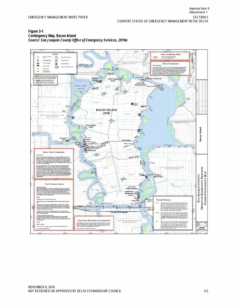
Local Emergency Preparedness and Response In addition to serving as the designated central authority for coordinating activities during an emergency, the San Joaquin County OES has facilitated and funded development of contingency maps by RDs to improve situational awareness, analysis, and decision making when levee integrity is jeopardized. These maps can be downloaded and viewed from a dedicated Web site (http://www.sjmap.org/oesfcm). An example of such a contingency map is given in Figure 3-1 for Bacon Island.
Agenda Item 9 Attachment 1
EMERGENCY MANAGEMENT WHITE PAPER SECTION 3 CURRENT STATUS OF EMERGENCY MANAGEMENT IN THE DELTA
NOVEMBER 8, 2010 NOT REVIEWED OR APPROVED BY DELTA STEWARDSHIP COUNCIL 3-5
Figure 3-1 Contingency Map, Bacon Island Source: San Joaquin County Office of Emergency Services, 2010a
Agenda Item 9 Attachment 1
SECTION 3 EMERGENCY MANAGEMENT WHITE PAPER CURRENT STATUS OF EMERGENCY MANAGEMENT IN THE DELTA
NOVEMBER 8, 2010 3-6 NOT REVIEWED OR APPROVED BY DELTA STEWARDSHIP COUNCIL
The contingency maps are further described as follows (Baldwin, 2010b):
“These contingency plans have taken the form of ‘flood contingency maps’ completed for areas with a common hydrological threat. The innovative mapping format displays information in relation to the most important component of floods, geography. The maps have been a highly successful method of sharing information and improving joint operations. The maps display historical, critical topographical, and survey information that are needed for effective situation analysis and decision-making. The maps also display pre-identified joint coordination processes and pre-determined engineering options for reducing flooding impact.”
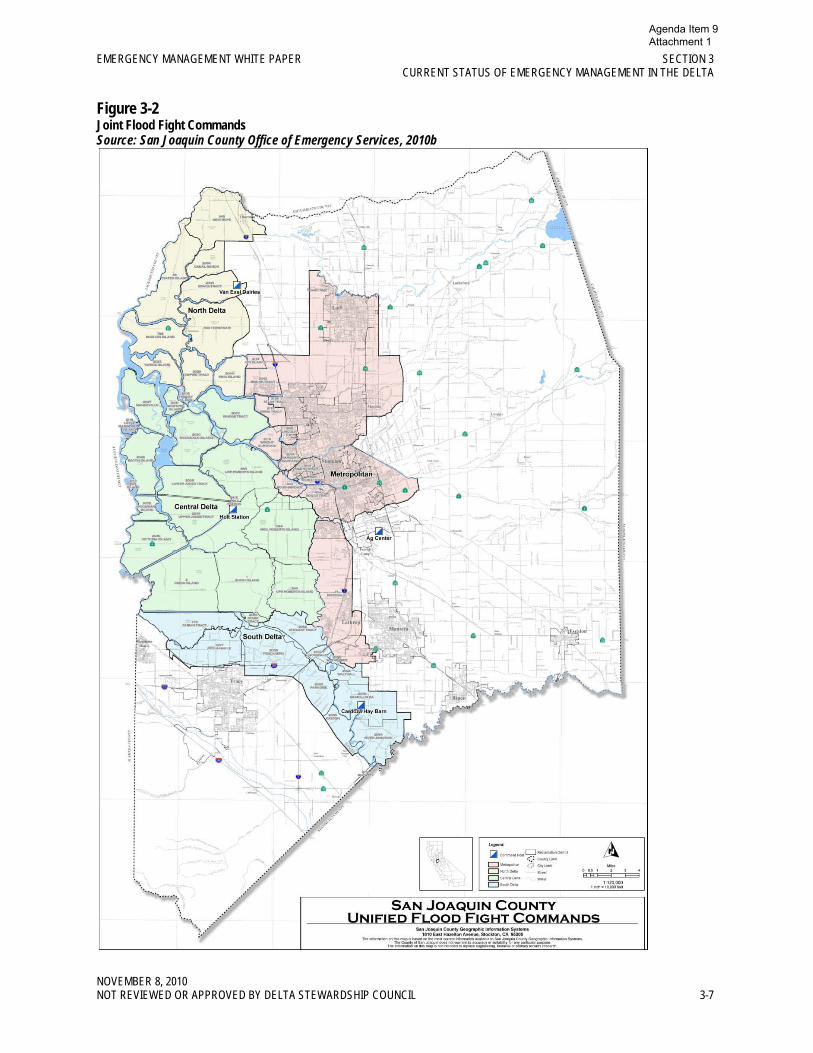
The San Joaquin County OES has further facilitated RD preparedness by voluntarily assuming “responsibility for assisting its RDs to meet their command and coordination responsibilities in an actual flood. Several Delta “joint flood fight commands” have been created that provide the basis for joint command and coordination activities between the many RDs and State and Federal agencies directly supporting their flood fight operations. The Office of Emergency Services directly facilitates the operations of these joint commands” (Baldwin, 2010b).
A map of the San Joaquin County joint flood fight commands is shown in Figure 3-2.
Agenda Item 9 Attachment 1
EMERGENCY MANAGEMENT WHITE PAPER SECTION 3 CURRENT STATUS OF EMERGENCY MANAGEMENT IN THE DELTA
NOVEMBER 8, 2010 NOT REVIEWED OR APPROVED BY DELTA STEWARDSHIP COUNCIL 3-7
Figure 3-2 Joint Flood Fight Commands Source: San Joaquin County Office of Emergency Services, 2010b
Agenda Item 9 Attachment 1
SECTION 3 EMERGENCY MANAGEMENT WHITE PAPER CURRENT STATUS OF EMERGENCY MANAGEMENT IN THE DELTA
NOVEMBER 8, 2010 3-8 NOT REVIEWED OR APPROVED BY DELTA STEWARDSHIP COUNCIL
Mr. Baldwin further describes the preparedness contributions of San Joaquin County OES as follows (2010b):
“It is absolutely necessary that appropriate specialized equipment be acquired to support operations reflected on the maps if these plans and procedures are to be effective. The San Joaquin County Office of Emergency Services has acquired equipment identified in the planning process as being essential to effective response and continues to acquire needed equipment as funding becomes available.
In regard to flood fight operations, the office maintains several large storage containers at the California Youth Authority Facility near the Stockton Airport. These containers contain large amounts of sandbags, plastic visquine, and other materials needed to address common threats to levees. These supplies will support major problems that may arise within the RDs. The districts maintain their own supplies for typical and minor problems that occur on levees during the flood. The OES containers can be moved to the vicinity of the problem and are equipped with lights and power so that they can serve as an officer for managing the materials. The San Joaquin County Office of Emergency Services also has the authority through the written San Joaquin Operational Area Agreement to support RDs with additional supplies or engineering contracting services if necessary.
In regard to supporting other public safety operations, the San Joaquin County Office of Emergency Services maintains three mobile radio transmitters for providing information to residents that are awaiting evacuation orders or evacuating. Equipment has been stockpiled to convert bulk fuel carriers so they can directly fuel evacuation vehicles. The office also maintains supplies of passes, signs, and other equipment that would be needed to implement procedures outlined on the evacuation maps.”
The details of other county preparedness and response plans have not been reviewed. Those counties are, however, participating in the Task Force and are apparently being assisted by the USCAE to upgrade their preparedness resources such as contingency maps.
Regional Emergency Preparedness and Response The current activities and responsibilities for emergency preparedness and response on a regional level in the Delta by state and federal agencies or commissions are described in this section.
Delta Protection Commission The mission of the DPC is to adaptively protect, maintain, and, where possible, enhance and restore the overall quality of the Delta environment consistent with the Delta Protection Act, and the Land Use and Resource Management Plan for the Primary Zone. This includes, but is not limited to, agriculture, wildlife habitat, and recreational activities. The goal of the DPC is to ensure orderly, balanced conservation and development of Delta land resources, and improved flood protection.
Although the DPC does not have an emergency management authority or responsibility, it has been assisting with the collaboration among the five counties, DWR, and Cal EMA to develop an integrated and unified approach for emergency preparedness in the Delta. Its initial efforts culminated in a Phase I Report authored by the Center for Collaborative Policy (CCP, 2008). The effort is being continued through the Delta Multi-Hazard Coordination Task Force in response to SB 27, as described above.
Agenda Item 9 Attachment 1
EMERGENCY MANAGEMENT WHITE PAPER SECTION 3 CURRENT STATUS OF EMERGENCY MANAGEMENT IN THE DELTA
NOVEMBER 8, 2010 NOT REVIEWED OR APPROVED BY DELTA STEWARDSHIP COUNCIL 3-9
Department of Water Resources The DWR’s Division of Flood Management, Flood Operations Branch coordinates flood operations with various federal, state, and local agencies, and is responsible for operating the State–Federal Flood Operations Center in Sacramento. The Branch Chief is the State–Federal Flood Operations Center’s primary liaison with Cal EMA on flood events, potential high-water situations, and other flood emergency issues. The Flood Operations Branch works year-round on emergency preparedness and coordination, and conducts pre-season workshops.
The FOC in Sacramento coordinates flood response activities, including Delta high water and levee emergencies. When activated during flood emergencies, flood incidents, or other high-water events, depending on the scale of the event, the center is staffed in compliance with SEMS with additional personnel from other branches within the DWR and cooperating agencies. It disseminates flood forecasts and warnings to the public. During emergency situations, the FOC is the facility from which the DWR centrally coordinates emergency response.
Year-round the FOC is the focal point for the gathering, analysis, and dissemination of flood and water-related information to stakeholders. It also tracks incidents with potential flood impacts.
The DWR Delta Interim Emergency Operations Plan: The DWR has developed a “Delta Emergency Operations Plan Concept Paper” (DWR, 2007a) that inventoried and assembled available Delta emergency operations information and supplemented it in straightforward ways to create a Delta Interim Emergency Operations Plan. It was intended for use by the DWR in thinking about and responding to near-term Delta emergencies. The document was considered to be a first step in developing a more detailed plan that would include much more stakeholder input, more extensive preparedness measures, and more sophisticated mechanisms for analyzing and choosing appropriate response strategies and organizing the implementation of a response. It recognizes the paramount priority of human life in emergencies (rescue, evacuation, and medical care) and the associated objective of reducing property damage. It defers to the agencies within the established Incident Command Structure that have expertise and responsibility for rescue, evacuation, and medical care, such as Cal EMA, CalFire, the California highway patrol, the United States Coast Guard, local OES, local law enforcement, and local fire; but the DWR recognizes its legal responsibility to participate in and assist those endeavors in accordance with SEMS priorities, especially to protect people’s lives.
The DWR Delta Interim Emergency Operations Plan concentrates on DWR’s primary responsibilities for flood fighting, levee repair and maintenance/restoration of Delta water quality, and water supply resources. It identifies specific response actions, especially relative to flood fights and water quality, and provides summary sheets on each. The response actions are categorized as immediate (first day), short-term (days 2 to 5), mid-term (days 6 to 14), and long-term (15 days or later) based on when the action would likely be effective and implemented. A summary sheet is provided for each action indicating a responsible party, a description of the action, the Delta region affected, the timeframe, expected impacts, constraints, and additional comments. The sheets provide an accessible resource for emergency personnel to use in understanding the action, assessing its applicability, and implementing it, if appropriate.
The DWR Emergency Preparedness, Response and Recovery Project: The DWR is continuing to enhance its emergency preparedness and response capabilities through an ongoing project. The project is designing and implementing in-Delta storage and transfer sites for rock and other flood-fight material. It is also performing studies to develop emergency analysis tools and response strategies, so the Incident Management Team can anticipate incident progression in response to various control factors. Finally, it is preparing documents for assisting emergency managers in recognizing action alternatives and evaluating their associated decisions.
Agenda Item 9 Attachment 1
SECTION 3 EMERGENCY MANAGEMENT WHITE PAPER CURRENT STATUS OF EMERGENCY MANAGEMENT IN THE DELTA
NOVEMBER 8, 2010 3-10 NOT REVIEWED OR APPROVED BY DELTA STEWARDSHIP COUNCIL
United States Army Corps of Engineers The Water Supply, Reliability, and Environmental Improvement Act (PL 108-361) authorizes the USACE to design and construct levee stability projects for purposes such as flood damage reduction, ecosystem restoration, water supply, water conveyance, and water quality objectives as outlined in the CALFED Bay-Delta Program, Programmatic Record of Decision. Furthermore, Section 103(f)(3)(B) of the Water Supply, Reliability, and Environmental Improvement Act authorizes the USACE to undertake the eight following activities:
1. Reconstruct Delta levees to a base level of protection (also known as the ‘‘PL 84–99 standard”);
2. Enhance the stability of levees that have particular importance in the system through the Delta Levee Special Improvement Projects Program;
3. Develop best management practices to control and reverse land subsidence on Delta islands;
4. Develop a Delta Levee Emergency Management and Response Plan that will enhance the ability of Federal, State, and local agencies to rapidly respond to levee emergencies;
5. Develop a Delta Risk Management Strategy after assessing the consequences of Delta levee failure from floods, seepage, subsidence, and earthquakes;
6. Reconstruct Delta levees using, to the maximum extent practicable, dredged materials from the Sacramento River, the San Joaquin River, and the San Francisco Bay in reconstructing Delta levees;
7. Coordinate Delta levee projects with flood management, ecosystem restoration, and levee protection projects of the lower San Joaquin River and lower Mokelumne River floodway improvements and other projects under the Sacramento-San Joaquin Comprehensive Study; and,
8. Evaluate and, if appropriate, rehabilitate the Suisun Marsh levees.
The Water Resources Development Act (WRDA) of 2007, amended the authority granted to the USACE under PL 108-361. The USACE issued guidance for the implementation of the supplemental authority granted under Section 3015 of the WRDA of 2007. This guidance was issued through a CECW-PB Memorandum dated 11 August 2008, titled, “Implementation Guidance for the Water Resources Development Act of 2007 (WRDA 2007) – Section 3015, CALFED Levee Stability.”
In support of Activity No. 4, the USACE signed a Memorandum of Agreement with the DWR to initiate the Geographic Information Systems Flood Contingency Mapping and Phase 1 of an Emergency Response Plan for the Delta Region. Based on coordination with the RDs, counties, and state agencies, a draft report for Phase 1 is expected to be published in summer 2011. The flood contingency maps produced as part of Phase 1 will be developed in a style comparable to the maps already produced by San Joaquin County.
Island and Tract Eligibility for Disaster Assistance In the Delta, various programs for disaster assistance are available or restricted depending on program rules and the characteristics of a Delta island or tract levee. The following major categories are relevant.
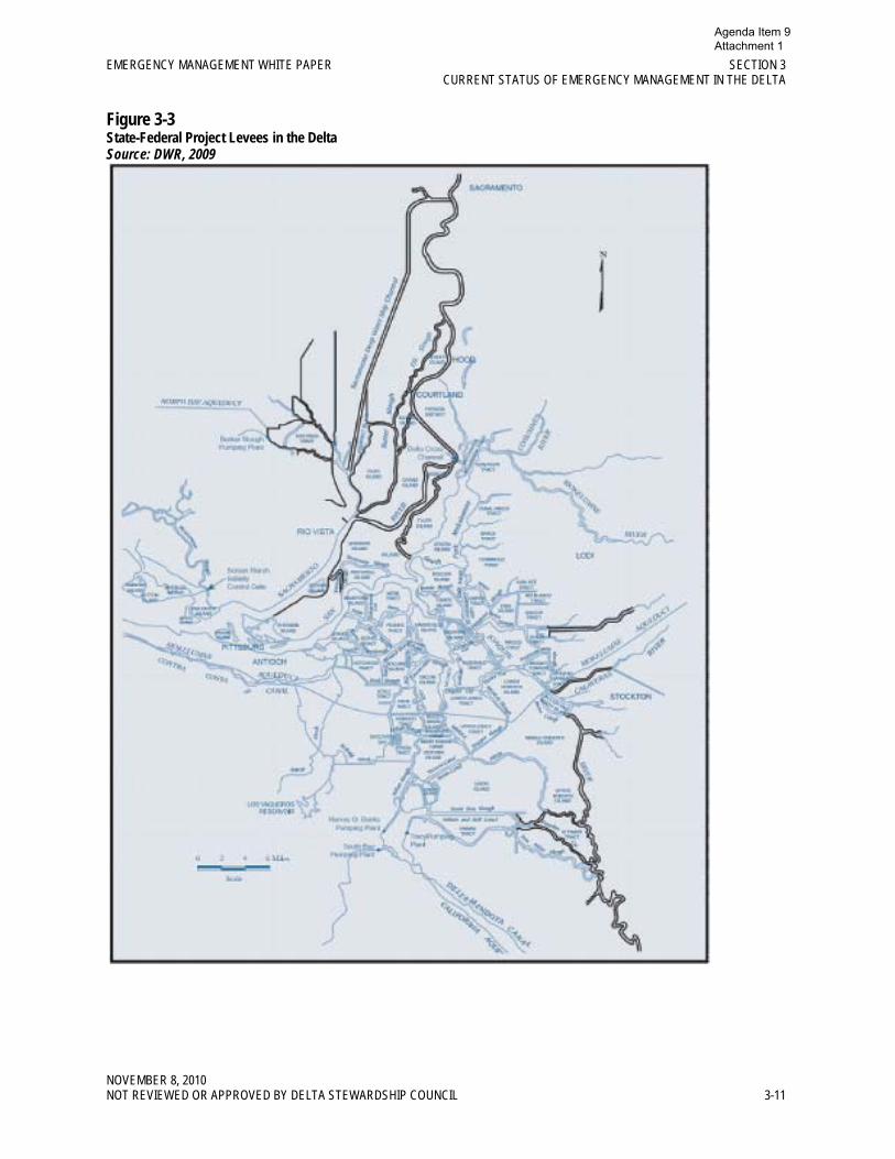
Project Levees In the Delta, the principal features of the state/federal flood control projects are the project levees, as shown in Figure 3-3. The state, as the non-federal sponsor of these projects, has given its assurance that the levees will be maintained to federal standards. The levees are eligible for USACE emergency
Agenda Item 9 Attachment 1
EMERGENCY MANAGEMENT WHITE PAPER SECTION 3 CURRENT STATUS OF EMERGENCY MANAGEMENT IN THE DELTA
NOVEMBER 8, 2010 NOT REVIEWED OR APPROVED BY DELTA STEWARDSHIP COUNCIL 3-11
Figure 3-3 State-Federal Project Levees in the Delta Source: DWR, 2009
Agenda Item 9 Attachment 1
SECTION 3 EMERGENCY MANAGEMENT WHITE PAPER CURRENT STATUS OF EMERGENCY MANAGEMENT IN THE DELTA
NOVEMBER 8, 2010 3-12 NOT REVIEWED OR APPROVED BY DELTA STEWARDSHIP COUNCIL
assistance (flood fighting) under PL 84-99 to save lives or protect improved properties from floods when this federal assistance is needed to supplement local and state efforts.
Levees may be characterized as having “active status” or “inactive status” under the USACE’s Rehabilitation and Inspection Program (RIP). A project levee is placed on active status if it has passed the most recent federal “continuing eligibility” inspection. A project levee is placed on inactive status if it has not passed its most recent inspection. The status determines a levee’s eligibility for assistance.
Active Status A project levee with active status may be eligible for “rehabilitation” assistance under the USACE’s PL 84-99 program. To determine eligibility, the damage to the levee would be evaluated for rehabilitation, provided that a flood caused the damage2
It is noted that USACE maintenance and inspection requirements are becoming more rigorous. Especially troublesome is the USACE’s recent effort to enforce more stringent vegetation standards that call for no woody vegetation at all on levees or within 15 feet of levees. Although the DWR has protested this policy, the USACE has been insistent. The result could be “inactive status” for many project levees.
. USACE rehabilitation assistance is provided only if analyses of the rehabilitation project results in a benefit/cost (B/C) ratio greater than 1.0. Rehabilitation assistance for project levees, when it is provided, covers 100 percent of the costs to flood fight and rehabilitate the levee.
Inactive Status A project levee that has been placed on inactive status would still be eligible for flood-fight assistance, but not for rehabilitation assistance. The same would apply for levees on active status if the analysis of rehabilitation costs and benefits resulted in a B/C ratio that was less than 1.0. Limited federal financial assistance (75 percent) for rehabilitation of the levee would have to be obtained from FEMA, as allowed by the Stafford Act, if there has been a presidential disaster declaration. The non-federal share would be partially covered by state disaster aid from Cal EMA (75 percent of the non-federal share).
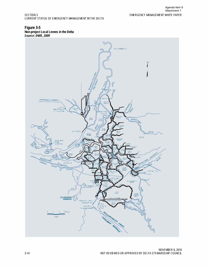
Non-project Levees Many Delta islands and tracts are protected by non-project levees (see Figure 3-4). Non-project levees may be eligible for disaster assistance if they meet certain criteria and, in some cases, if a presidential disaster declaration has been issued.
2 USACE rehabilitation assistance under Public Law 84-99 relative to other damage (e.g., earthquakes or volcanoes) is permitted only with prior headquarters approval.
Agenda Item 9 Attachment 1
EMERGENCY MANAGEMENT WHITE PAPER SECTION 3 CURRENT STATUS OF EMERGENCY MANAGEMENT IN THE DELTA
NOVEMBER 8, 2010 NOT REVIEWED OR APPROVED BY DELTA STEWARDSHIP COUNCIL 3-13
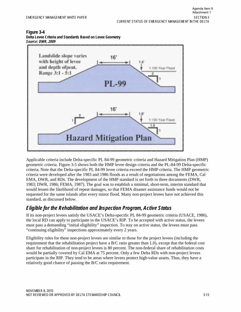
Figure 3-4 Delta Levee Criteria and Standards Based on Levee Geometry Source: DWR, 2009
Applicable criteria include Delta-specific PL 84-99 geometric criteria and Hazard Mitigation Plan (HMP) geometric criteria. Figure 3-5 shows both the HMP levee design criteria and the PL-84-99 Delta-specific criteria. Note that the Delta-specific PL 84-99 levee criteria exceed the HMP criteria. The HMP geometric criteria were developed after the 1983 and 1986 floods as a result of negotiations among the FEMA, Cal EMA, DWR, and RDs. The development of the HMP standard is set forth in three documents (DWR, 1983; DWR, 1986; FEMA, 1987). The goal was to establish a minimal, short-term, interim standard that would lessen the likelihood of repeat damages, so that FEMA disaster assistance funds would not be requested for the same islands after every minor flood. Many non-project levees have not achieved this standard, as discussed below.
Eligible for the Rehabilitation and Inspection Program, Active Status If its non-project levees satisfy the USACE’s Delta-specific PL 84-99 geometric criteria (USACE, 1986), the local RD can apply to participate in the USACE’s RIP. To be accepted with active status, the levees must pass a demanding “initial eligibility” inspection. To stay on active status, the levees must pass “continuing eligibility” inspections approximately every 2 years.
Eligibility rules for these non-project levees are similar to those for the project levees (including the requirement that the rehabilitation project have a B/C ratio greater than 1.0), except that the federal cost share for rehabilitation of non-project levees is 80 percent. The non-federal share of rehabilitation costs would be partially covered by Cal EMA at 75 percent. Only a few Delta RDs with non-project levees participate in the RIP. They tend to be areas where levees protect high-value assets. Thus, they have a relatively good chance of passing the B/C ratio requirement.
Agenda Item 9 Attachment 1
SECTION 3 EMERGENCY MANAGEMENT WHITE PAPER CURRENT STATUS OF EMERGENCY MANAGEMENT IN THE DELTA
NOVEMBER 8, 2010 3-14 NOT REVIEWED OR APPROVED BY DELTA STEWARDSHIP COUNCIL
Figure 3-5 Non-project Local Levees in the Delta Source: DWR, 2009
Agenda Item 9 Attachment 1
EMERGENCY MANAGEMENT WHITE PAPER SECTION 3 CURRENT STATUS OF EMERGENCY MANAGEMENT IN THE DELTA
NOVEMBER 8, 2010 NOT REVIEWED OR APPROVED BY DELTA STEWARDSHIP COUNCIL 3-15
Meet Hazard Mitigation Plan or Delta-specific Public Law 84-99 Geometric Criteria If all the non-project levees protecting an island or tract meet the HMP geometric criteria (and have a survey within the past 5 years to prove it), the RD is eligible for the FEMA disaster assistance for levee rehabilitation, under the Stafford Act, provided that a presidential disaster declaration has been issued. The FEMA cost share is 75 percent; Cal EMA would provide 75 percent of the non-federal share. Thus, the local, RD share could be as low as 6.25 percent of the eligible costs.
This repair and rehabilitation assistance would also be available for districts that have Delta-specific PL 84-99 levees and are not participating in the USACE’s RIP.
Do Not Meet the Hazard Mitigation Program Geometric Criteria Most islands and tracts in the Delta that are protected by non-project levees have at least some of their levees that fail to meet the HMP criteria. The HMP standard was supposed to be implemented for all Delta non-project levees by September 10, 1991, as a precondition for receiving FEMA disaster assistance if there were a levee breach (see DWR, 1990). At this point (19 years after the deadline), the HMP standard has not yet been achieved for many Delta levees, although many RDs have made considerable progress. The FEMA has denied claims for disaster assistance when any of an island’s levees are not in strict compliance. If the RD is found to be ineligible for FEMA assistance, the state becomes the source of any disaster assistance funds granted. The RD is still eligible for 75 percent disaster assistance from Cal EMA (quadrupling the state disaster assistance costs), but the local share will also quadruple to 25 percent. Many districts may not be able to recover from a disaster if they must shoulder this share of the cost for repairs.
The FEMA and Cal EMA have recently negotiated a Memorandum of Understanding (MOU) reaffirming the HMP geometric requirements (see Cal EMA and FEMA, 2010). There is a small amount of flexibility indicated in the Memorandum of Understanding regarding “…consideration of eligibility for emergency repairs and emergency management work should be based on whether a District has demonstrated a good faith effort to substantially comply with eligibility criteria….” It is not clear what will be adequate to demonstrate a good faith effort. But hopefully, this will at least avoid some of the denials based on minor points that are rumored to have occurred in the past. It seems clear, however, that a RD that wants to receive FEMA disaster assistance must work diligently to improve all its levees to meet the HMP requirements.
Agenda Item 9 Attachment 1

Agenda Item 9 Attachment 1
NOVEMBER 8, 2010 NOT REVIEWED OR APPROVED BY DELTA STEWARDSHIP COUNCIL 4-1
Section 4 References
Baldwin, R. E. 2010a. Responses to questions posed by the Council by Ronald E. Baldwin, Director of Emergency Operations, San Joaquin County. Delta Stewardship Council Risk Reduction and Coequal Goals Workshop. July.
Baldwin, R. E. 2010b. San Joaquin County Office of Emergency Services Responses to Delta Stewardship Council Questions (Memorandum to DPC dated April 27, 2010). May.
Blue Ribbon Task Force. 2008. Delta Vision Strategic Plan. Sacramento: State of California Resources Agency. October.
Cal EMA and FEMA. 2010. Memorandum of Understanding Between the State of California Emergency Management Agency and the U. S. Department of Homeland Security’s Federal Emergency Management Agency Regarding Criteria for Public Assistance Eligibility for Reclamation Districts in the Sacramento/San Joaquin Legal Delta. February.
Cal EMA. 2010a. Foundation for the Standardized Emergency Management System. Sacramento: State of California. January.
Cal EMA. 2010b. Sacramento-San Joaquin Delta Multi-Agency Coordination System (MACS), Operations Guide. Fourth Draft. Sacramento: Sate of California. October.
CCP (Center for Collaborative Policy). 2008. A Strategy for Collaborative Emergency Response Planning in California’s Delta Region, Phase I Report. Prepared for Delta Protection Commission and Governor’s Office of Emergency Services. Sacramento: California State University Center for Collaborative Policy. June.
DWR, 2009. Delta Risk Management Strategy, Executive Summary, Phase 1. Prepared by the California Department of Water Resources from documents developed by URS Corporation / Jack R. Benjamin & Associates, Inc. February.
DWR (Department of Water Resources). 2007a. Delta Emergency Operations Plan Concept Paper. Sacramento. April. Accessed October 2010: http://www.water.ca.gov/floodmgmt/docs/Delta_EOP_Concept_Paper-March_2007.pdf
DWR. 1983. State of California Flood Hazard Mitigation Plan for the Sacramento–San Joaquin Delta. Prepared for the Office of Emergency Services. Sacramento. September.
Agenda Item 9 Attachment 1
SECTION 4 EMERGENCY MANAGEMENT WHITE PAPER REFERENCES
NOVEMBER 8, 2010 4-2 NOT REVIEWED OR APPROVED BY DELTA STEWARDSHIP COUNCIL
DWR. 1986. “State of California – Flood Hazard Mitigation Plan – 180-Day Report Prepared in Accordance with Section 406 of Public Law 93-288; Section 2 – The Sacramento – San Joaquin Delta Flood Hazard Mitigation Plan.” Sacramento. August.
DWR. 1990. “Interim Report on the Status of Sacramento–San Joaquin Delta Flood Hazard Mitigation Plan.” Sacramento. September.
DWR. 2007b. Levee Failures in the Sacramento-San Joaquin River Delta. Prepared by URS and DWR. Sacramento. August. Accessed October 2010: http://www.water.ca.gov/floodmgmt/docs/DeltaLeveeFailures_FMA_200709.pdf.
FEMA (Federal Emergency Management Agency). 1987. “Amendment #5, FEMA/State Agreement FEMA-758-DR-CA.” Letter Agreement from Robert L. Vickers, Regional Director and Countersigned by the Governor’s Representative. Region IX. April 28 and 29, 1987.
Little Hoover Commission. 2006. Safeguarding the Golden State: Preparing for Catastrophic Events. Report 184. Sacramento. April.
Mount, J., and R. Twiss. 2005. Subsidence, Sea Level Rise, and Seismicity in the Sacramento-San Joaquin Delta. San Francisco Estuary & Watershed Science. Vol 3, Issue 1, Article 5. March.
NOAA (National Ocean and Atmospheric Administration). 2010. 2004 NOAA Tide Predictions: Borden Highway Bridge, Middle River. Accessed October 2010. http://tidesandcurrents.noaa.gov/get_predictions.shtml?year=2004&stn=5144+Port+Chicago&secstn=Borden+Highway+Bridge,+Middle+River&thh=%2b4&thm=51&tlh=%2b4&tlm=53&hh=*0.65&hl=*0.57
San Joaquin County Office of Emergency Services. 2010a. Contingency Map for Bacon Island. Accessed October 2010. http://www.sjmap.org/oesfcm/BaconIsland_Quad.pdf.
San Joaquin County Office of Emergency Services. 2010b. Joint Flood Fight Commands. Accessed October 2010. http://www.sjmap.org/oesfcm/UnitedFloodFightCommands.pdf.
San Joaquin County, 1995. San Joaquin County Flood Evacuation Plan. Accessed October 2010. http://www.sjgov.org/Oes/getplan/Delta_Flood_plan.pdf.
USACE (U.S. Army Corps of Engineers). 1987. “Guidelines for Rehabilitation of Non-Federal Levees in the Sacramento – San Joaquin Delta, CA.” CESPK-EM. September.
Agenda Item 9 Attachment 1