Embed Size (px)
Citation preview
EIA Guidance forLarge-Scale Hydropower in Pakistan
The designation of geographical entities in this book and the presentation of the material do not imply theexpression of any opinion whatsoever on the part of IUCN concerning the legal status of any country,territory or area, or of its authorities, or concerning the delimitation of its frontiers or boundaries.
Published by:IUCN Pakistan (National Impact Assessment Programme)
Copyright:© 2014 Government of Pakistan and International Union for Conservation of Nature and Natural Resources.
EIA Guidelines For Large-Scale Hydropower In Pakistan was prepared under the National ImpactAssessment Programme (NIAP), a joint initiative of the Government of Pakistan and IUCN Pakistan withthe financial support of the Embassy of the Kingdom of the Netherlands (EKN).
Citation is encouraged. Reproduction and/or translation of this publication for educational or other non-commercial purposes is authorised without prior written permission from IUCN Pakistan, provided thesource is fully acknowledged. Reproduction of this publication for resale or other commercial purposes isprohibited without prior written permission from IUCN Pakistan.
The opinions expressed in this document do not constitute an endorsement by the EKN.
Citation:Meynell, Peter-John and Nazia Zakir. 2014. EIA Guidelines for Large-Scale Hydropower In Pakistan.Islamabad: IUCN Pakistan. 136 pp.
ISBN 978-969-643-014-8
Editor:Sadia Rauf
Technical Support:Netherlands Commission for Environmental Assessment (NCEA)
Facilitation:Ahmad SaeedDanish Rashdi
Design:Hasan Ruvi Zaman
Cover Photographs:Dr. Parvaiz Naim
Printed by:Rosette Printers (Pvt) Limited
Available from:IUCN PakistanNational Impact Assessment ProgrammeHouse No. 2, Street 83Embassy Road, G-6/4, IslamabadTel: +92 (51) 2271027-34Fax: +92 (51) 2271017www.niap.pk
01
02
Table of contents
1 Introduction1.1 How to use the guidelines1.2 Using the scoping questionnaire and checklist
2.1 Hydropower resources2.2 Institutions for hydropower development in Pakistan2.3 Policy for Power Generation projects
3.1 Types of hydropower project 3.2 Sizes of hydropower projects 3.3 Designs and construction materials
5.1 Environmental Progress in Pakistan 5.2 Constitutional Provision 5.2.1 Prior 18th Amendment 5.2.2 Post 18th Amendment 5.3 National Policy and Administrative Framework (Prior 18th Amendment)5.3.1 Organizational Setup 5.3.2 Pakistan Environmental Protection Act, 1997 5.4 National Policy and Administrative Framework (Post 18th Amendment)5.4.1 Environmental Protection Legislation5.4.2 Organizational Setup 5.4.3 Law Related Regulations and Guidance 5.4.4 Interdepartmental Coordination 5.4.5 Environment related Statutes 5.5 Other Requirements 5.5.1 Policies & Strategies 5.5.2 International conventions and transboundary agreements
6.1 EIA and IEE process 6.2 Guidelines for Environmental Assessment 6.3 National Environmental Quality Standards 6.4 Screening and EIA thresholds
Part 2 - The EIA process
13
344
5
558
8
81010
12
17
17
17171717181818191919202020212121
24
24262626
27
282929313233
2 Hydropower development in Pakistan
3 Types and components of hydropower
4 International safeguards and guidance available
EIA Guidelines for large-scale hydropower in Pakistan
Acronyms Executive Summary Part 1 - Background
5 Legal requirements for EIAs in Pakistan
6 Regulations and Guidance for Environmental Assessment
7.1 Section 1: Hydropower plant specifications 7.2 Section 2: Information about the location and its sensitivity 7.3 Section 3: General Environmental Impact Questions 7.4 Section 4: If there is a reservoir or head pond formed 7.5 Section 5: If the project diverts water from one river to another 7.6 Section 6: Social issues - If people and their livelihoods are affected
7 Scoping to identify main environmental impacts
Table of contents8.1 Stakeholder consultation 8.2 Public consultation and disclosure 8.3 Stakeholder consultation processes 8.4 Resettlement 8.5 Compensation
11.1 Hydrology 11.2 Climate Change 11.3 Seismicity 11.4 Impacts on sensitive locations 11.4.1 Protected Areas (national parks, game reserves, wildlife sanctuaries) 11.4.2 Buffer zones of protected area and biodiversity corridors 11.4.3 Ranges of endangered or threatened animals 11.4.4 Unique or aesthetically valuable landscapes or water forms (deep pools, rapids, waterfalls)11.4.5 Wetlands 11.4.6 Important stretches of the river for fish breeding and spawning, 11.4.7 Unregulated river or undammed river 11.4.8 Existing or proposed irrigation schemes near or associated with the HPP11.4.9 Unstable land areas where there has been soil erosion and landslips 11.4.10 Area used by ethnic minority groups 11.4.11 Archaeological and cultural sites
12.1 Physical impacts 12.1.1 Air quality 12.1.2 Noise and vibration 12.1.3 Erosion and Sedimentation 12.1.4 Soil quality 12.2 Hydrological impacts 12.2.1 Surface water hydrology 12.2.2 Surface water quality 12.2.3 Groundwater and Groundwater quality12.3 Terrestrial ecosystems 12.3.1 Ecosystems 12.3.2 Terrestrial flora and fauna 12.3.3 Endangered species and critical habitats 12.3.4 Protected areas 12.3.5 Land take and Landuse change12.3.6 Impacts on Agriculture
Part 3 – Addressing environmental and social issues related to hydropower
34343738
?40
41
4142434647484849
50
52
52
5254555656575758
58596060606161
61
63636363636464646465656666686868
10 Developing the EMP and monitoring
EIA Guidelines for large-scale hydropower in Pakistan
8 Stakeholder consultation, Resettlement and Compensation
9.1 Structure of an EIA report 9.2 Consideration of alternatives for hydropower EIAs 9.3 Description of the large hydropower project 9.4 Impact zones of hydropower projects 9.5 Phasing of large hydropower projects 9.6 Carrying out baseline surveys 9.7 Impact assessment criteria 9.8 EIA Tools and assessment methods
9 Guidance for completion of certain sections of EIAs
11 Key design issues
12 Key environmental impacts during construction
03
Table of contents12.3.7 Forestry 12.4 Aquatic ecosystems 12.4.1 Aquatic flora and fauna 12.4.2 Fisheries and aquaculture12.5 Infrastructure impacts12.5.1 Urban, commercial and industrial areas 12.5.2 Access roads and transmission lines 12.6 Safety issues during construction
18.1 Identifying project affected communities and persons 18.1.1 Vulnerable groups – poor households, women and children 18.1.2 Vulnerable groups – ethnic minorities and indigenous peoples 18.2 Construction impacts 18.2.1 Physical disturbance – dust, noise, vibration 18.2.2 Traffic and road safety 18.2.3 Loss of infrastructure
6869696969696970
70
71717272727275767777787878788181818282828282838383838485
87
8889
9192
92949495959696
EIA Guidelines for large-scale hydropower in Pakistan
13.1 Physical impacts 13.1.1 Air quality 13.1.2 Greenhouse gas emissions 13.1.3 Noise and vibration 13.2 Hydrological impacts 13.2.1 Surface water hydrology 13.2.2 River diversion schemes and river hydrology 13.2.3 Impacts of river flow changes 13.3 Water quality 13.3.1 Surface water quality13.3.2 Floating objects in the reservoir 13.4 Groundwater 13.4.1 Groundwater quality 13.5 Erosion and Sedimentation 13.5.1 Geomorphology changes in the river downstream 13.6 Terrestrial ecosystems 13.6.1 Terrestrial flora and fauna 13.6.2 Endangered species 13.6.3 Protected areas 13.6.4 Land take and Landuse change 13.6.5 Agriculture 13.6.6 Forestry 13.7 Aquatic ecosystems 13.7.1 Ecological changes in the reservoir 13.7.2 Aquatic flora in the reservoir 13.7.3 Reservoir fish and fisheries 13.7.4 Fisheries and aquaculture 13.7.5 Aquatic flora and fauna – downstream
13 Key environmental issues during operation
14 Catchment or Watershed Management Plan 15 Assessing cumulative impacts of hydropower 16 Transboundary impacts 17 Dam safety and disaster management 18 Socio-economic issues
Table of contents18.2.4 Operational changes in hydrology 18.2.5 Loss of safe drinking water sources 18.2.6 Health and safety issues during construction 18.2.7 Social pressures 18.3 Resettlement and relocation 18.4 Loss of livelihoods and livelihood restoration 18.4.1 Tourism and recreation 18.4.2 Employment opportunities 18.5 Establishing a Grievance redress mechanism
9697979798
100101101101
102103
104105
107
108110
111
112113114116
117118
120
123126
127
EIA Guidelines for large-scale hydropower in Pakistan
19 Benefit sharing 20 Gender impact assessment 21 Health impact assessments22 Archaeological and Cultural Impact Assessment
Annex 1 - About the National Impact Assessment ProgrammeAnnex 2 - Listing of existing and proposed large hydropower projects over 50MW in PakistanAnnex 3 - Regulations and Guidelines Annex 4 - Rapid environmental and social assessment scoping checklist for large-scale hydropower in Pakistan
Section 1: Information about the plant and its footprint Section 2: Information about the location and its sensitivity Section 3: General Environmental Impact Questions Section 4: If there is a reservoir or head pond formed Section 5: If the project diverts water from one river to another Section 6: Social issues - If people and their livelihoods are affected
Annex 5 - Draft TOR for an EIA consultant team Annex 6 - Outline of a typical EIA report Annex 7 - Outline of a typical Environmental Management Plan Annex 8 - Outline of a Disaster Management Plan
List of figuresFigure 2.1: Map of Pakistan showing a) the main hydropower projects and b) the
provinces and main rivers
Figure 3.1: Schematic of large hydropower dam
Figure 4.1: Contents list of the World Bank General EHS Guidelines
Figure 4.2: Stages in the project development for application of HSAP
Figure 4.3: Sustainability Assessment Topics of the HSAP
Figure 6.1: IEE/EIA Process in Pakistan
Figure 8.1: Stakeholders of AJK Hydropower Development mapped according to
Interest and Influence
Figure 8.2: Public consultation process
Figure 9.1: Site selection and comparison of location alternatives may be an
important environmental factor
Figure 9.2: Main impact zones of a large hydropower project
Figure 11.1: Natural hydrographs of several Pakistan rivers
Figure 11.2: Dams and Barrages in Pakistan and the Indus River catchment
hydrograph for July to August 2010
Figure 11.3: Seismic zones in Pakistan
Figure 11.4: Fragmentation of protected areas by large hydropower schemes
Figure 13.1: Storage volumes in a reservoir (cross section)
Figure 13.2: Diagram of a HPP showing the balance of flows in different parts of the
river and associated hydrograph
Figure 13.3: Diagram of HPP with diversion of water from the intake river to a recipient
river, showing balance of flows and associated hydrograph of the
recipient river
Figure 13.4: Sediment accumulation in a reservoir
Figure 13.5: Sediment management options in a reservoir
Figure 13.6: Ecological and fisheries changes occurring after the inundation of Lake
Kariba on the Zambezi, Africa
Figure 18.1: People and communities in different impact zones adversely affected by
hydropower
Figure 19.1: Schematic of money flows from a hydropower project
EIA Guidelines for large-scale hydropower in Pakistan
List of tablesTable 2.1: Hydropower potential in Pakistan
Table 5.1: Relevant sections covering EIA and IEE in provincial legislation
Table 5.2: International conventions signed by Pakistan
Table 5.3: Allocation of water between the provinces according to Water
Apportionment Accord
Table 8.1: Stakeholders for Large Hydropower Projects
Table 12.1: Matrix of potential impacts associated with construction of hydropower
projects
Table 12.2: Ecozones and ecoregions of Pakistan, Global 200 eco-regions highlighted
in bold
Table 13.1: Matrix of potential impacts associated with operation of hydropower
projects
Table 13.2: Hydrological implications of different hydropower operations
EIA Guidelines for large-scale hydropower in Pakistan
List of text boxesBox no. 1 Ghazi Barotha – a run-of-river diversion scheme
Box no. 2 The Neelum-Jhelum hydropower project – an interbasin diversion
scheme
Box no. 3 Size definitions for Hydropower in Pakistan
Box no. 4 Tarbela Dam
Box no. 5 Tarbela case study for World Commission on Dams, 2000
Box no. 6 Subjects under federal jurisdiction
Box no. 7 Impacts on different provinces – the case of Diamer Bhasha Dam
Box no. 8 Threshold for IEEs or EIAs for hydropower projects
Box no. 9 Inappropriateness of the 50 MW threshold
Box no. 10 Potential questions for stakeholder identification
Box no. 11 Reducing resettlement numbers through changing the design of
Mangla Dam raising
Box no. 12 Outline for Resettlement Plan as per ADB Safeguards Policy
Box no. 13 Phases and activities of a large hydropower project
Box no. 14 River Poonch Mahseer National Park, Poonch, Kotli, Mirpur (Azad
Jammu and Kashmir)
Box no. 15 Spawning of Mahseer, Tor tor
Box no. 16 Biodiversity offsets
Box no. 17 Biomass Removal Plan
Box no. 18 Assessing environmental flows
Box no. 19 WWF proposes an ecological conservation plan for Diamer Bhasha
Dam
Box no. 20 Recommendation on incorporating cumulative impact assessment
into EIAs from Strategic Environmental Assessment of Hydropower
Development in AJK
Box no. 21 Transnational impacts of changing flows from the Kishanganga Dam
Box no. 22 Dams Safety Organisation
Box no. 23 IFC requirements for Free, Prior Informed Consent
Box no. 24 Resettlement in the Ghazi-Barotha Hydropower Project
Box no. 25 Archaeological impact assessment of the Diamer Bhasha Dam on the
Chilas rock carvings
EIA Guidelines for large-scale hydropower in Pakistan
AcronymsCBD Convention on Biological Diversity
ADB Asian Development Bank
AP Affected Person
BOD Biological Oxygen Demand
BBOP Business and Biodiversity Offsets Programme
BRP Biomass Removal Plan
CCD Climate Change Division
COD Chemical Oxygen Demand
CEIA /CIA Cumulative Environmental Impact Assessment
CDM Clean Development Mechanism
CITES Convention on International Trade in Endangered Species of Wild
Fauna and Flora
CFRD Concrete-face rock-fill dam
CMS Convention on the Conservation of Migratory Species of Wild Animals
DSO Dam Safety Organisation
EIA Environmental Impact Assessment
EMP Environmental Management Plan
EPA Environmental Protection Agency
EPFIs Equator Principles Financial Institutions
EPP Emergency Preparedness Plan
ESMS Environmental and Social Management System
FPIC Free, Prior and Informed Consent
FSL Full Supply Level
GoP Government of Pakistan
GHG Green House Gases
GLOF Glacier Lake Outburst Flood
GRM Grievance Redress Mechanism
GWh Giga Watt Hours
HPP Hydropower Plant
HSAP Hydropower Sustainability Assessment Protocol
ICOLD International Commission on Large Dams
IEE Initial Environmental Examination
IFC International Finance Corporation
IHA International Hydropower Association
IUCN International Union for Conservation of Nature and Natural Resources
IWRM Integrated Water Resource Management
kv kilo volts
kW Kilo Watt
LAA Land Acquisition Act 1894
LA&R Land Acquisition and Resettlement Unit
MAF Million Acre Feet
MCE Maximum Credible Earthquake
MOL Minimum Operating Level
EIA Guidelines for large-scale hydropower in Pakistan
AcronymsMRC Mekong River Commission
MW Mega Watts
NCS National Conservation Strategy
NIAP National Impact Assessment Programme
NDMA National Disaster Management Authority
NEPRA National Electric Power Regulatory Authority
NEQS National Environmental Quality Standards
NESPAK National Engineering Services Pakistan
NDMA National Disaster Management Authority
NGO Non-Governmental Organisation
NHA National Highway Authority
NOC No Objection Certificate
NPCC National Power Construction Company
NTDC National Transmission & Dispatch Company
PA Protected Area
PC Planning Commission of Pakistan
PAP Project Affected Person
PEPC Pakistan Environmental Protection Council
Pak-EPA Pakistan Environmental Protection Agency
PEPA Pakistan Environmental Protection Act
PEPCO Pakistan Electric Power Company
PEPO Pakistan Environmental Protection Ordinance
PPIB Private Power and Infrastructure Board
PMPIU Project Management and Policy Implementation Unit
PSS project-specific standards
RAP Resettlement Action Plan
RIS Reservoir Induced Seismicity
RSAT Rapid Sustainability Assessment Tool
RCC Roller-compacted Concrete
SEE Safety Evaluation Earthquake
SEA Strategic Environmental Assessment
TOR Terms of Reference
UNCED United Nations Conference on Environment and Development
UNCCD United Nations Convention to Combat Desertification
UNFCCC United Nations Framework Convention on Climate Change
VECs valued environmental and social components
WAPDA Water and Power Development Authority
WCD World Commission on Dams
WWF World Wide Fund for Nature
EIA Guidelines for large-scale hydropower in Pakistan
1
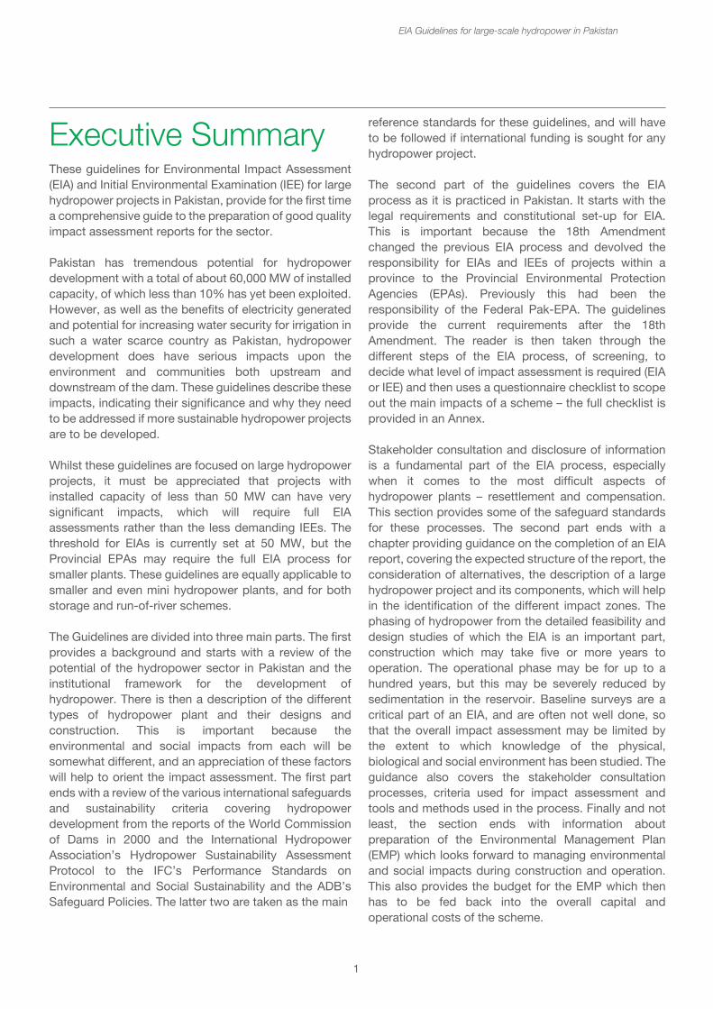
These guidelines for Environmental Impact Assessment (EIA) and Initial Environmental Examination (IEE) for large hydropower projects in Pakistan, provide for the first time a comprehensive guide to the preparation of good quality impact assessment reports for the sector.
Pakistan has tremendous potential for hydropower development with a total of about 60,000 MW of installed capacity, of which less than 10% has yet been exploited. However, as well as the benefits of electricity generated and potential for increasing water security for irrigation in such a water scarce country as Pakistan, hydropower development does have serious impacts upon the environment and communities both upstream and downstream of the dam. These guidelines describe these impacts, indicating their significance and why they need to be addressed if more sustainable hydropower projects are to be developed.
Whilst these guidelines are focused on large hydropower projects, it must be appreciated that projects with installed capacity of less than 50 MW can have very significant impacts, which will require full EIA assessments rather than the less demanding IEEs. The threshold for EIAs is currently set at 50 MW, but the Provincial EPAs may require the full EIA process for smaller plants. These guidelines are equally applicable to smaller and even mini hydropower plants, and for both storage and run-of-river schemes.
The Guidelines are divided into three main parts. The first provides a background and starts with a review of the potential of the hydropower sector in Pakistan and the institutional framework for the development of hydropower. There is then a description of the different types of hydropower plant and their designs and construction. This is important because the environmental and social impacts from each will be somewhat different, and an appreciation of these factors will help to orient the impact assessment. The first part ends with a review of the various international safeguards and sustainability criteria covering hydropower development from the reports of the World Commission of Dams in 2000 and the International Hydropower Association’s Hydropower Sustainability Assessment Protocol to the IFC’s Performance Standards on Environmental and Social Sustainability and the ADB’s Safeguard Policies. The latter two are taken as the main
reference standards for these guidelines, and will have to be followed if international funding is sought for any hydropower project.
The second part of the guidelines covers the EIA process as it is practiced in Pakistan. It starts with the legal requirements and constitutional set-up for EIA. This is important because the 18th Amendment changed the previous EIA process and devolved the responsibility for EIAs and IEEs of projects within a province to the Provincial Environmental Protection Agencies (EPAs). Previously this had been the responsibility of the Federal Pak-EPA. The guidelines provide the current requirements after the 18th Amendment. The reader is then taken through the different steps of the EIA process, of screening, to decide what level of impact assessment is required (EIA or IEE) and then uses a questionnaire checklist to scope out the main impacts of a scheme – the full checklist is provided in an Annex.
Stakeholder consultation and disclosure of information is a fundamental part of the EIA process, especially when it comes to the most difficult aspects of hydropower plants – resettlement and compensation. This section provides some of the safeguard standards for these processes. The second part ends with a chapter providing guidance on the completion of an EIA report, covering the expected structure of the report, the consideration of alternatives, the description of a large hydropower project and its components, which will help in the identification of the different impact zones. The phasing of hydropower from the detailed feasibility and design studies of which the EIA is an important part, construction which may take five or more years to operation. The operational phase may be for up to a hundred years, but this may be severely reduced by sedimentation in the reservoir. Baseline surveys are a critical part of an EIA, and are often not well done, so that the overall impact assessment may be limited by the extent to which knowledge of the physical, biological and social environment has been studied. The guidance also covers the stakeholder consultation processes, criteria used for impact assessment and tools and methods used in the process. Finally and not least, the section ends with information about preparation of the Environmental Management Plan (EMP) which looks forward to managing environmental and social impacts during construction and operation. This also provides the budget for the EMP which then has to be fed back into the overall capital and operational costs of the scheme.
Executive Summary
EIA Guidelines for large-scale hydropower in Pakistan
2
Part 3 provides the technical details of the main impacts. The aim of this section is to provide an understanding of the impacts and their significance, guidance on how the impact may be addressed in the EIA report and some of the mitigation measures that may be taken to avoid, reduce, rehabilitate or compensate for the impact. It starts with a description of three critical design factors – hydrology, climate change, and seismicity. It then covers the impacts on sensitive locations – hydropower plants are often constructed in remote biologically, culturally and socially sensitive areas, and it is important to protect these.
The next chapters deal with the key construction impacts and key operational impacts. These chapters cover the main physical, hydrological and biological impacts. The chapter ends with sections on cumulative impact assessment of the scheme in the wider context together with other developments. This is now a frequently required part of EIAs. Transboundary impacts are also becoming increasingly important, both between countries and between provinces. Hydropower development carries the risks of such impacts beyond the immediate boundaries of the project and these will need to be assessed.
Dam safety is a critical issue which the dam developer, the regulators and the communities downstream are acutely interested in. Dam break analysis and the development of emergency procedures is an aspect that should be carried out separately and reported on in the EIA. Catchment or watershed management relates to the protection of the area above the reservoir especially to minimize the problem of sediment accumulation in the reservoir, and also providing an opportunity for biodiversity offsets.
The final chapter of the guidelines covers the socio-economic issues, identifying the project affected communities and vulnerable groups, both during the construction and operational phases. The issues of resettlement and relocation, compensation and development of livelihood options for the resettled peoples are amongst the most difficult that the hydropower project will have to resolve. Resettlement is not just for physically displaced households but also for those that are economically displaced, i.e. have lost assets that contribute to their livelihoods, e.g. land or access to the means of production. The guidance covers
subjects such as setting up a Grievance Redress Mechanism, Benefit Sharing, Gender Impact Assessments, Health Impact Assessments and Archaeological and Cultural Impact Assessments all of which require specialist inputs.
Finally there are a number of annexes including the checklist, and sample report outlines and TORs for consultants.
EIA Guidelines for large-scale hydropower in Pakistan
Part 1 - Background
3
1. Introduction
In the past decade there has been a resurgence of interest in large hydropower as a clean source of power with much lower emissions of green-house gases than fossil fuel power stations. Despite these advantages, large hydropower does come with some significant social and environmental concerns that need management and mitigation if hydropower is to live up to its image as a sustainable source of power. In the past, the hydropower sector has neglected some of these issues, with the result that new projects have to address this rather poor reputation and deal with the public concern and sometimes direct opposition against large hydropower schemes. Hydropower development in Pakistan illustrates both, some of the past poor practice as well as good examples of more sustainable hydropower projects.
EIA was introduced as a requirement in Pakistan under Pakistan Environmental Protection Ordinance (PEPO) 1983. In 1997, PEPO was replaced by Pakistan Environmental Protection Act 1997 (PEPA’97), which further strengthened EIA as a legal requirement and introduced IEE / EIA Review Rules 2000. To support the implementation of the EIA regime in the country, several guidelines have also been developed. Some of the notable guidelines are EIA Guidelines 1986, EIA Energy Sector Guidelines 1992, EIA Guidelines for Oil & Gas Exploration in Environmentally Sensitive Areas 1997, Sub-sectoral Guidelines for twenty-two sectors were developed by Khyber Pakhtunkhwa EPA, and Sub-sectoral Guidelines of three sectors developed by Balochistan EPA. Landmark projects like the oil and gas development in Kirthar National Park have managed to bring EIA to the forefront but have also highlighted that there is still ample scope to strengthen its practice in Pakistan.
The National Impact Assessment Programme (NIAP) jointly implemented by the Government of Pakistan (GoP) and International Union for Conservation of Nature (IUCN) between 2010 and 2014 aimed to contribute to sustainable development in Pakistan through strengthening the Environmental Impact Assessment (EIA) process and introducing Strategic Environmental Assessment (SEA) in national development planning (see Annex 1).
As part of its strategy to carry out capacity building, develop tools and procedures, NIAP recognized the unavailability of quality sectoral guidelines as one of the major constraints faced by the EPAs in adequately reviewing EIAs of large projects. NIAP commissioned guidelines for three sectors of national and strategic significance to assist its partner EPAs for i) transboundary natural gas pipelines, ii) large hydro dams and iii) coal-fired thermal power plants.
This set of guidance for large hydropower dams aims to help the sector in identifying the most relevant environmental and social issues and the options for management and mitigation. Whilst the focus for this guidance is the preparation of the Environmental Impact Assessment (EIA) and Social Impact Assessment (SIA) reports, the real purpose is to ensure that the environmental and social management of large hydropower projects is improved and that good practice in Environmental and Social management and monitoring plans (EMP) is followed during the implementation of such projects.
The objective of developing EIA guidelines is to support the relevant institutions especially Environmental Protection Agencies, Planning and Development Departments, financial lending institutions, consultants and civil society organizations in effectively undertaking and reviewing EIAs of large hydro plants to ensure environmental and social safeguards compliance.
The main audiences for this guidance are:
a. Proponents of hydropower projects, who need to understand the main environmental and social issues associated with their project, how they may be addressed and the cost implications for managing them. They may also use the guidelines to scope out the potential impacts and prepare the Terms of Reference for their environmental consultants.
b. Their consultants preparing EIA reports and EMPs.
c. Provincial and Federal Government agencies involved in appraising and approving EIAs and issuing compliance certificates and monitoring the environmental performance during implementation. The guidelines will help these agencies in ensuring that the EIA documentation covers the relevant aspects.
EIA Guidelines for large-scale hydropower in Pakistan
As part of its strategy to carry out capacity building, develop tools and procedures, NIAP recognized the unavailability of quality sectoral guidelines as one of the major constraints faced by the EPAs in adequately reviewing EIAs of large projects. NIAP commissioned guidelines for three sectors of national and strategic significance to assist its partner EPAs for i) transboundary natural gas pipelines, ii) large hydro dams and iii) coal-fired thermal power plants.
This set of guidance for large hydropower dams aims to help the sector in identifying the most relevant environmental and social issues and the options for management and mitigation. Whilst the focus for this guidance is the preparation of the Environmental Impact Assessment (EIA) and Social Impact Assessment (SIA) reports, the real purpose is to ensure that the environmental and social management of large hydropower projects is improved and that good practice in Environmental and Social management and monitoring plans (EMP) is followed during the implementation of such projects.
The objective of developing EIA guidelines is to support the relevant institutions especially Environmental Protection Agencies, Planning and Development Departments, financial lending institutions, consultants and civil society organizations in effectively undertaking and reviewing EIAs of large hydro plants to ensure environmental and social safeguards compliance.
The main audiences for this guidance are:
a. Proponents of hydropower projects, who need to understand the main environmental and social issues associated with their project, how they may be addressed and the cost implications for managing them. They may also use the guidelines to scope out the potential impacts and prepare the Terms of Reference for their environmental consultants.
b. Their consultants preparing EIA reports and EMPs.
c. Provincial and Federal Government agencies involved in appraising and approving EIAs and issuing compliance certificates and monitoring the environmental performance during implementation. The guidelines will help these agencies in ensuring that the EIA documentation covers the relevant aspects.
4
Whilst there is a considerable body of information on the environmental and social impacts of large hydropower world-wide, which is briefly reviewed in chapter 3, nothing has been prepared yet for direct application in Pakistan. A number of sector specific EIA guidelines have already been prepared by Pakistan EPA, notably for major thermal power stations, major chemical and manufacturing plants, industrial estates and new township development, major roads, sewerage schemes, wind power projects, and oil and gas exploration.1 The unavailability of quality sectoral guidelines is recognized as one of the major constraints faced by the EPAs in adequately reviewing EIAs of large projects. Little attention has been paid towards the development of guidelines in emerging sectors that have national and international significance.
These EIA sectoral guidelines for large hydropower have been prepared under the National Impact Assessment Programme (NIAP). As described in Annex 1, NIAP has commissioned three EIA sectoral guidance documents to be prepared – Transboundary natural gas pipelines, Coal fired power stations and large hydropower – because these developments are of national and strategic significance.
1.1 How to use the guidelines
These guidelines are organized in three sections. The first section presents the background information about the development of large hydropower in Pakistan and the typical components of a large hydropower project. The first section also contains a review of international and donor guidance that is available on the environmental and social impacts of large hydropower. These EIA guidelines for Pakistan have drawn upon the best practice that these represent to ensure that they complement existing standards and safeguards of the lending agencies, such as the World Bank, IFC and the ADB, and that there is no contradiction in the advice given.
The second section deals with the EIA process and the legislation and regulations in Pakistan. Whilst this information is available in the general EIA guidelines for Pakistan,2 this section interprets these in the context of hydropower. It outlines the requirements for EIA reports and EMPs and then addresses particular sections of EIA reports that require some interpretation in the context of
hydropower development, namely the consideration of alternatives to the hydropower project, and the identification of impact zones associated with such projects and the need for well-defined baseline studies in these zones as well as consultation processes. It also stresses the very different impacts that need to be described in the phases of a hydropower project.
The third section describes the principal environmental and social issues associated with large hydropower development, and the management and mitigation measures that should be considered when addressing them in the EMP. This section is closely linked with the questionnaire checklist that can be used for scoping a large hydropower project or when appraising EIA reports to ensure that they adequately cover the impacts. The questionnaire/checklist is found in Annex 2. The narrative sections clearly identify the relevant questions, so that the explanation of the question can be readily found.
The Annexes provide examples of:
• Annex 3 - Questionnaire checklist.• Annex 4 - Terms of Reference for an EIA for large hydropower.• Annex 5 - The contents list for an EIA report for large hydropower.• Annex 6 - The contents list for an EMP for large hydropower.• Annex 7 - The contents list for a Disaster management plan associated with large hydropower.
1.2 Using the scoping questionnaire and checklist
The scoping questionnaire found in chapter 6 can be used at different stages.
• Initial scoping for Developer and consultant to assess need for an IEE or EIA.• More detailed definition of Terms of Reference for EIA.• For EPAs to review effectiveness and quality of coverage of impacts in EIA report.
The scoping checklist has been used as a structure for Part 3 of these guidelines, so that the link between the potential impacts on the checklist and the guidance provided can be used directly. The information provided in Part 3 covers a) the significance of the impact, b) how the impact may be described in the EIA i.e. what information to use and c) what mitigation and management measures might be considered.
EIA Guidelines for large-scale hydropower in Pakistan
1For access to these sectoral EIA guidelines already published, refer to http://www.environ-ment.gov.pk/info.htm 2Policy and procedures for the filing, review and approval of environmental assessments http://www.environment.gov.pk/eia_pdf/C_P_P11SeptRev.pdf Guidelines for the preparation and review of environmental reports http://www.environ-ment.gov.pk/eia_pdf/D_rev_enReprt.pdf
hydropower development, namely the consideration of alternatives to the hydropower project, and the identification of impact zones associated with such projects and the need for well-defined baseline studies in these zones as well as consultation processes. It also stresses the very different impacts that need to be described in the phases of a hydropower project.
The third section describes the principal environmental and social issues associated with large hydropower development, and the management and mitigation measures that should be considered when addressing them in the EMP. This section is closely linked with the questionnaire checklist that can be used for scoping a large hydropower project or when appraising EIA reports to ensure that they adequately cover the impacts. The questionnaire/checklist is found in Annex 2. The narrative sections clearly identify the relevant questions, so that the explanation of the question can be readily found.
The Annexes provide examples of:
• Annex 3 - Questionnaire checklist.• Annex 4 - Terms of Reference for an EIA for large hydropower.• Annex 5 - The contents list for an EIA report for large hydropower.• Annex 6 - The contents list for an EMP for large hydropower.• Annex 7 - The contents list for a Disaster management plan associated with large hydropower.
1.2 Using the scoping questionnaire and checklist
The scoping questionnaire found in chapter 6 can be used at different stages.
• Initial scoping for Developer and consultant to assess need for an IEE or EIA.• More detailed definition of Terms of Reference for EIA.• For EPAs to review effectiveness and quality of coverage of impacts in EIA report.
The scoping checklist has been used as a structure for Part 3 of these guidelines, so that the link between the potential impacts on the checklist and the guidance provided can be used directly. The information provided in Part 3 covers a) the significance of the impact, b) how the impact may be described in the EIA i.e. what information to use and c) what mitigation and management measures might be considered.
5
2. Hydropower development in Pakistan
2.1 Hydropower resources
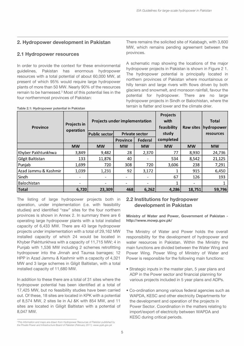
In order to provide the context for these environmental guidelines, Pakistan has enormous hydropower resources with a total potential of about 60,000 MW, at present of which 95% would require large hydropower plants of more than 50 MW. Nearly 90% of the resources remain to be harnessed.3 Most of this potential lies in the four northernmost provinces of Pakistan:
The listing of large hydropower projects both in operation, under implementation (i.e. with feasibility studies) and identified “raw” sites for the four northern provinces is shown in Annex 2. In summary there are 6 operating large hydropower plants with a total installed capacity of 6,433 MW. There are 43 large hydropower projects under implementation with a total of 29,162 MW installed capacity of which 24 would be located in Khyber Pakhtunkhwa with a capacity of 11,715 MW; 4 in Punjab with 1,536 MW including 2 schemes retrofitting hydropower into the Jinnah and Taunsa barrages; 12 HPP in Azad Jammu & Kashmir with a capacity of 4,321 MW and 3 large schemes in Gilgit Baltistan, with a total installed capacity of 11,680 MW.
In addition to these there are a total of 31 sites where the hydropower potential has been identified at a total of 17,425 MW, but no feasibility studies have been carried out. Of these, 18 sites are located in KPK with a potential of 8,574 MW, 2 sites lie in AJ &K with 854 MW, and 11 sites are located in Giligit Baltistan with a potential of 8,047 MW.
There remains the solicited site of Kalabagh, with 3,600 MW, which remains pending agreement between the provinces.
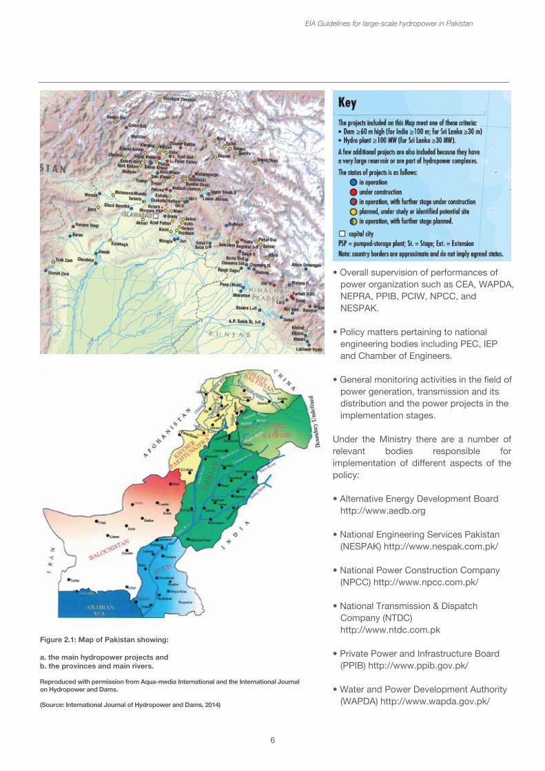
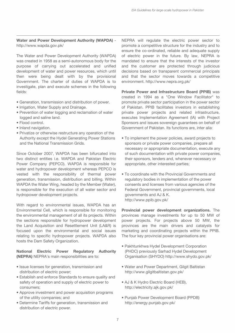
A schematic map showing the locations of the major hydropower projects in Pakistan is shown in Figure 2 1. The hydropower potential is principally located in northern provinces of Pakistan where mountainous or hilly terrain and large rivers with flows driven by both glaciers and snowmelt, and monsoon rainfall, favour the potential for hydropower. There are no large hydropower projects in Sindh or Balochistan, where the terrain is flatter and lower and the climate drier.
EIA Guidelines for large-scale hydropower in Pakistan
3This information and maps are drawn from Hydropower Resources of Pakistan published by the Private Power and Infrastructure Board of Pakistan (February 2011). www.ppib.gov.pk
Table 2.1: Hydropower potential in Pakistan
2.2 Institutions for hydropower development in Pakistan
Ministry of Water and Power, Government of Pakistan - http://www.mowp.gov.pk/
The Ministry of Water and Power holds the overall responsibility for the development of hydropower and water resources in Pakistan. Within the Ministry the main functions are divided between the Water Wing and Power Wing. Power Wing of Ministry of Water and Power is responsible for the following main functions:
• Strategic inputs in the master plan, 5 year plans and ADP in the Power sector and financial planning for various projects included in 5 year plans and ADPs.
• Co-ordination among various federal agencies such as WAPDA, KESC and other electricity Departments for the development and operation of the projects in Power Sector. Coordination in the matters relating to import/export of electricity between WAPDA and KESC during critical periods.
6
EIA Guidelines for large-scale hydropower in Pakistan
2.2 Institutions for hydropower development in Pakistan
Ministry of Water and Power, Government of Pakistan - http://www.mowp.gov.pk/
The Ministry of Water and Power holds the overall responsibility for the development of hydropower and water resources in Pakistan. Within the Ministry the main functions are divided between the Water Wing and Power Wing. Power Wing of Ministry of Water and Power is responsible for the following main functions:
• Strategic inputs in the master plan, 5 year plans and ADP in the Power sector and financial planning for various projects included in 5 year plans and ADPs.
• Co-ordination among various federal agencies such as WAPDA, KESC and other electricity Departments for the development and operation of the projects in Power Sector. Coordination in the matters relating to import/export of electricity between WAPDA and KESC during critical periods.
Figure 2.1: Map of Pakistan showing:
a. the main hydropower projects andb. the provinces and main rivers.
Reproduced with permission from Aqua-media International and the International Journalon Hydropower and Dams.
(Source: International Journal of Hydropower and Dams, 2014)
• Overall supervision of performances of power organization such as CEA, WAPDA, NEPRA, PPIB, PCIW, NPCC, and NESPAK.
• Policy matters pertaining to national engineering bodies including PEC, IEP and Chamber of Engineers.
• General monitoring activities in the field of power generation, transmission and its distribution and the power projects in the implementation stages.
Under the Ministry there are a number of relevant bodies responsible for implementation of different aspects of the policy:
• Alternative Energy Development Board http://www.aedb.org
• National Engineering Services Pakistan (NESPAK) http://www.nespak.com.pk/
• National Power Construction Company (NPCC) http://www.npcc.com.pk/
• National Transmission & Dispatch Company (NTDC) http://www.ntdc.com.pk
• Private Power and Infrastructure Board (PPIB) http://www.ppib.gov.pk/
• Water and Power Development Authority (WAPDA) http://www.wapda.gov.pk/
7
Water and Power Development Authority (WAPDA) - http://www.wapda.gov.pk/
The Water and Power Development Authority (WAPDA) was created in 1958 as a semi-autonomous body for the purpose of carrying out accelerated and unified development of water and power resources, which until then were being dealt with by the provisional Government. The charter of duties of WAPDA is to investigate, plan and execute schemes in the following fields:
• Generation, transmission and distribution of power.• Irrigation, Water Supply and Drainage.• Prevention of water logging and reclamation of water logged and saline land.• Flood control.• Inland navigation.• Privatize or otherwise restructure any operation of the Authority except the Hydel Generating Power Stations and the National Transmission Grids.
Since October 2007, WAPDA has been bifurcated into two distinct entities i.e. WAPDA and Pakistan Electric Power Company (PEPCO). WAPDA is responsible for water and hydropower development whereas PEPCO is vested with the responsibility of thermal power generation, transmission, distribution and billing. Within WAPDA the Water Wing, headed by the Member (Water), is responsible for the execution of all water sector and hydropower development projects.
With regard to environmental issues, WAPDA has an Environmental Cell, which is responsible for monitoring the environmental management of all its projects. Within the sections responsible for hydropower development the Land Acquisition and Resettlement Unit (LA&R) is focused upon the environmental and social issues relating to specific hydropower projects. WAPDA also hosts the Dam Safety Organization.
National Electric Power Regulatory Authority (NEPRA) NEPRA's main responsibilities are to:
• Issue licenses for generation, transmission and distribution of electric power;• Establish and enforce Standards to ensure quality and safety of operation and supply of electric power to consumers;• Approve investment and power acquisition programs of the utility companies; and• Determine Tariffs for generation, transmission and distribution of electric power.
NEPRA will regulate the electric power sector to promote a competitive structure for the industry and to ensure the co-ordinated, reliable and adequate supply of electric power in the future. By law, NEPRA is mandated to ensure that the interests of the investor and the customer are protected through judicious decisions based on transparent commercial principals and that the sector moves towards a competitive environment. http://www.nepra.org.pk/
Private Power and Infrastructure Board (PPIB) was created in 1994 as a "One Window Facilitator" to promote private sector participation in the power sector of Pakistan. PPIB facilitates investors in establishing private power projects and related infrastructure, executes Implementation Agreement (IA) with Project Sponsors and issues sovereign guarantees on behalf of Government of Pakistan. Its functions are, inter alia:
• To implement the power policies, award projects to sponsors or private power companies, prepare all necessary or appropriate documentation, execute any of such documentation with private power companies, their sponsors, lenders and, whenever necessary or appropriate, other interested parties;
• To coordinate with the Provincial Governments and regulatory bodies in implementation of the power consents and licenses from various agencies of the Federal Government, provincial governments, local governments and AJ & K. http://www.ppib.gov.pk/
Provincial power development organizations. The provinces manage investments for up to 50 MW of power projects. For projects above 50 MW, the provinces are the main drivers and catalysts for marketing and coordinating projects within the PPIB. The four key provincial power organisations are:
• Pakhtunkhwa Hydel Development Corporation (PHDC) previously Sarhad Hydel Development Organisation (SHYDO) http://www.shydo.gov.pk/
• Water and Power Department, Gilgit Baltistan http://www.gilgitbaltistan.gov.pk/
• AJ & K Hydro Electric Board (HEB), http://electricity.ajk.gov.pk/
• Punjab Power Development Board (PPDB) http://energy.punjab.gov.pk/
EIA Guidelines for large-scale hydropower in Pakistan
• Overall supervision of performances of power organization such as CEA, WAPDA, NEPRA, PPIB, PCIW, NPCC, and NESPAK.
• Policy matters pertaining to national engineering bodies including PEC, IEP and Chamber of Engineers.
• General monitoring activities in the field of power generation, transmission and its distribution and the power projects in the implementation stages.
Under the Ministry there are a number of relevant bodies responsible for implementation of different aspects of the policy:
• Alternative Energy Development Board http://www.aedb.org
• National Engineering Services Pakistan (NESPAK) http://www.nespak.com.pk/
• National Power Construction Company (NPCC) http://www.npcc.com.pk/
• National Transmission & Dispatch Company (NTDC) http://www.ntdc.com.pk
• Private Power and Infrastructure Board (PPIB) http://www.ppib.gov.pk/
• Water and Power Development Authority (WAPDA) http://www.wapda.gov.pk/
NEPRA will regulate the electric power sector to promote a competitive structure for the industry and to ensure the co-ordinated, reliable and adequate supply of electric power in the future. By law, NEPRA is mandated to ensure that the interests of the investor and the customer are protected through judicious decisions based on transparent commercial principals and that the sector moves towards a competitive environment. http://www.nepra.org.pk/
Private Power and Infrastructure Board (PPIB) was created in 1994 as a "One Window Facilitator" to promote private sector participation in the power sector of Pakistan. PPIB facilitates investors in establishing private power projects and related infrastructure, executes Implementation Agreement (IA) with Project Sponsors and issues sovereign guarantees on behalf of Government of Pakistan. Its functions are, inter alia:
• To implement the power policies, award projects to sponsors or private power companies, prepare all necessary or appropriate documentation, execute any of such documentation with private power companies, their sponsors, lenders and, whenever necessary or appropriate, other interested parties;
• To coordinate with the Provincial Governments and regulatory bodies in implementation of the power consents and licenses from various agencies of the Federal Government, provincial governments, local governments and AJ & K. http://www.ppib.gov.pk/
Provincial power development organizations. The provinces manage investments for up to 50 MW of power projects. For projects above 50 MW, the provinces are the main drivers and catalysts for marketing and coordinating projects within the PPIB. The four key provincial power organisations are:
• Pakhtunkhwa Hydel Development Corporation (PHDC) previously Sarhad Hydel Development Organisation (SHYDO) http://www.shydo.gov.pk/
• Water and Power Department, Gilgit Baltistan http://www.gilgitbaltistan.gov.pk/
• AJ & K Hydro Electric Board (HEB), http://electricity.ajk.gov.pk/
• Punjab Power Development Board (PPDB) http://energy.punjab.gov.pk/
8
2.3 Policy for Power Generation projects
The Pakistan Government Policy for Power generation projects was agreed in 2002. There are some specific points relating to hydropower projects and the environment which should be noted:
• Para 74 – All requirements of the Pakistan Environmental Protection Agency (PEPA) Act 1997, inter alia, relating to environmental protection, environmental impact and social soundness assessment shall have to be met.
3. Types and components of hydropower
Hydropower projects come in a number of different types and sizes, and these may have different environmental and social impacts. Construction methods also differ and his makes the early definition of the type and size of the project important when developing the EIA.
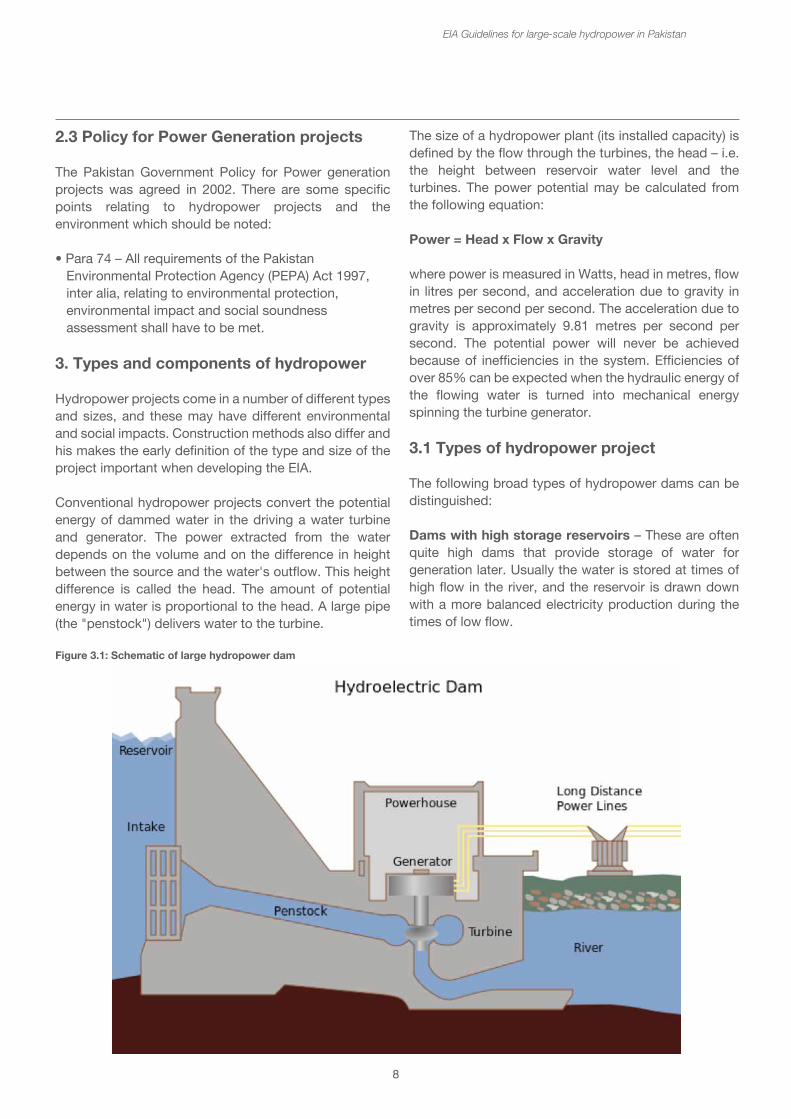
Conventional hydropower projects convert the potential energy of dammed water in the driving a water turbine and generator. The power extracted from the water depends on the volume and on the difference in height between the source and the water's outflow. This height difference is called the head. The amount of potential energy in water is proportional to the head. A large pipe (the "penstock") delivers water to the turbine.
EIA Guidelines for large-scale hydropower in Pakistan
Figure 3.1: Schematic of large hydropower dam
The size of a hydropower plant (its installed capacity) is defined by the flow through the turbines, the head – i.e. the height between reservoir water level and the turbines. The power potential may be calculated from the following equation:
Power = Head x Flow x Gravity
where power is measured in Watts, head in metres, flow in litres per second, and acceleration due to gravity in metres per second per second. The acceleration due to gravity is approximately 9.81 metres per second per second. The potential power will never be achieved because of inefficiencies in the system. Efficiencies of over 85% can be expected when the hydraulic energy of the flowing water is turned into mechanical energy spinning the turbine generator.
3.1 Types of hydropower project
The following broad types of hydropower dams can be distinguished:
Dams with high storage reservoirs – These are often quite high dams that provide storage of water for generation later. Usually the water is stored at times of high flow in the river, and the reservoir is drawn down with a more balanced electricity production during the times of low flow.
9
Most storage dams may store and release the water over a single year, but some very big dams have been designed to provide more than one year storage. Others may provide storage for less than a year, e.g. for six months or three months.
Run-of-River hydropower – These are dams that have small or no reservoir capacity, so the water coming from upstream must be used for generation at that moment, or must be allowed to bypass the dam. A hydropower project that has less than one month storage capacity may be classified as run-of river. The small storage capacity may be used to balance the flows, or to provide daily peaking or generation at times of peak demand for electricity (e.g. during daylight hours), with storage during the night. Generally peaking operation is not currently considered in Pakistan. Despite low storage capacity, many large run-of-river dams are quite high e.g. 40 – 50 m in order to take advantage of the increased head.
Pumped storage – This method produces electricity to supply high peak demands by moving water between reservoirs at different elevations. At times of low electrical demand, excess generation capacity is used to pump water into the higher reservoir. When there is higher demand, water is released back into the lower reservoir through a turbine. Pumped-storage schemes currently provide the most commercially important means of large-scale grid energy storage and improve the daily capacity factor of the generation system. There are no pumped storage schemes under consideration at the moment in Pakistan, where demand outstrips the supply.
Other distinguishing characteristics may be specified, for example:
Low head, large volume – This is typical for run-of-river dams where the full flow of the river is passed through the turbines over a relatively low head – even as low as 20m.
High head, small volume – The same amount of power may be generated by using a relatively small volume of water and dropping it down a high head from the intake through the penstock to the powerhouse. This type of scheme is often used when the water is being diverted some kilometers downstream or even into another river basin.
EIA Guidelines for large-scale hydropower in Pakistan
High head, large volume – This is the case for very large storage dams, in which large quantities of power can be generated from the high volumes of water passing through the turbines under the pressure of a reservoir water level that may be over 100 m or more above them.
Many HPPs have the powerhouse and other facilities located very close to the bottom of the dam. However, some schemes divert the water through a channel, pipe or tunnel to the power house which may be located a number of kilometres downstream. This design takes advantage of the topography and bends in the river, so that a high head may be achieved with a relatively short channel from the intake. This type of hydropower plant is a river diversion scheme and the main concern is the flow left in the river between the dam and the power house. In some schemes the dewatered stretch of river may be many kilometres downstream (see box no. 1).
Box 1: Ghazi Barotha – a run-of-river diversion scheme
About 1,600 cubic meter per second of water is diverted from the Indus River near the town of Ghazi about 7 km downstream of Tarbela Dam (3,478 MW). It then runs through a 100 metre wide and 9 metre deep open power channel down to the village of Barotha where the power complex is located. In the reach from Ghazi to Barotha, the Indus River inclines by 76 meters over a distance of 63 km. After passing through the powerhouse, the water is returned to the Indus. It has an installed capacity of 1,450 MW. The impacts of reduced flows in that section of the Indus between the diversion and the powerhouse have been significant both ecologically for the river and for the livelihoods of people living alongside the river.
Another form of river diversion scheme takes water from one river and diverts it into a different river. This is interbasin diversion. In this case the river where the intake has permanently less water flowing below the dam, whilst the recipient river has an flow increased by the same amount (see box no. 2).
10
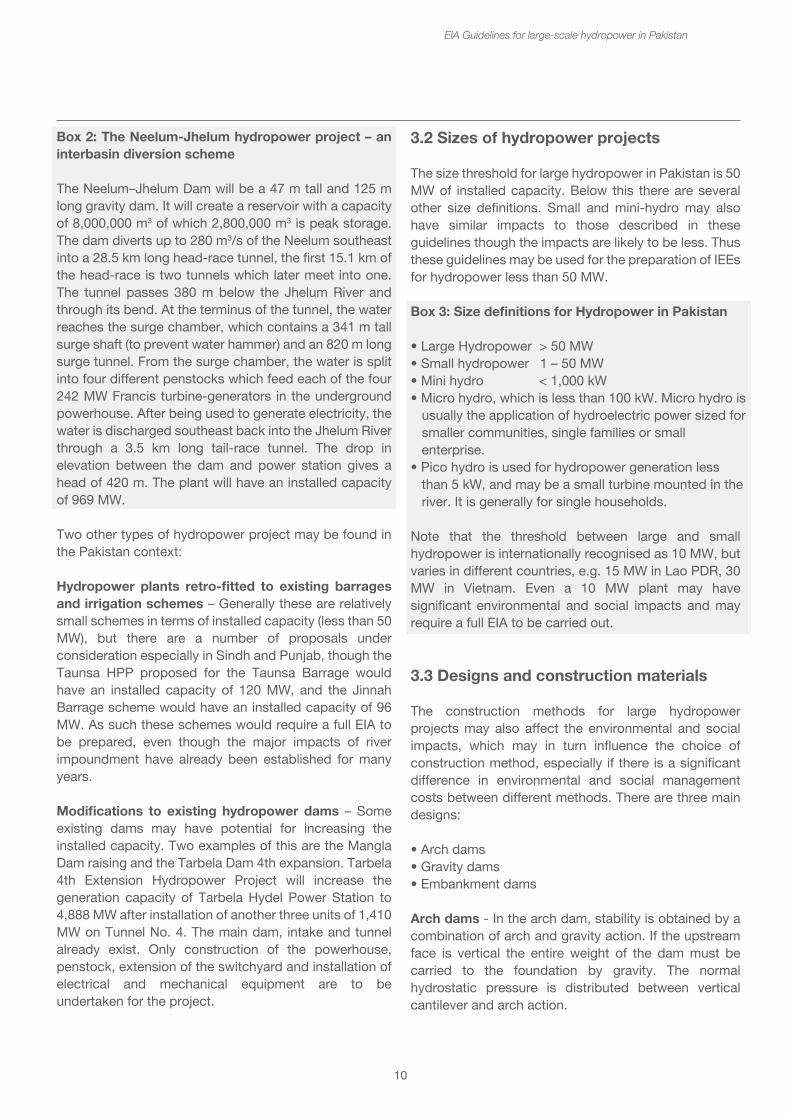
Box 2: The Neelum-Jhelum hydropower project – an interbasin diversion scheme
The Neelum–Jhelum Dam will be a 47 m tall and 125 m long gravity dam. It will create a reservoir with a capacity of 8,000,000 m3 of which 2,800,000 m3 is peak storage. The dam diverts up to 280 m3/s of the Neelum southeast into a 28.5 km long head-race tunnel, the first 15.1 km of the head-race is two tunnels which later meet into one. The tunnel passes 380 m below the Jhelum River and through its bend. At the terminus of the tunnel, the water reaches the surge chamber, which contains a 341 m tall surge shaft (to prevent water hammer) and an 820 m long surge tunnel. From the surge chamber, the water is split into four different penstocks which feed each of the four 242 MW Francis turbine-generators in the underground powerhouse. After being used to generate electricity, the water is discharged southeast back into the Jhelum River through a 3.5 km long tail-race tunnel. The drop in elevation between the dam and power station gives a head of 420 m. The plant will have an installed capacity of 969 MW.
Two other types of hydropower project may be found in the Pakistan context:
Hydropower plants retro-fitted to existing barrages and irrigation schemes – Generally these are relatively small schemes in terms of installed capacity (less than 50 MW), but there are a number of proposals under consideration especially in Sindh and Punjab, though the Taunsa HPP proposed for the Taunsa Barrage would have an installed capacity of 120 MW, and the Jinnah Barrage scheme would have an installed capacity of 96 MW. As such these schemes would require a full EIA to be prepared, even though the major impacts of river impoundment have already been established for many years.
Modifications to existing hydropower dams – Some existing dams may have potential for increasing the installed capacity. Two examples of this are the Mangla Dam raising and the Tarbela Dam 4th expansion. Tarbela 4th Extension Hydropower Project will increase the generation capacity of Tarbela Hydel Power Station to 4,888 MW after installation of another three units of 1,410 MW on Tunnel No. 4. The main dam, intake and tunnel already exist. Only construction of the powerhouse, penstock, extension of the switchyard and installation of electrical and mechanical equipment are to be undertaken for the project.
EIA Guidelines for large-scale hydropower in Pakistan
3.2 Sizes of hydropower projects
The size threshold for large hydropower in Pakistan is 50 MW of installed capacity. Below this there are several other size definitions. Small and mini-hydro may also have similar impacts to those described in these guidelines though the impacts are likely to be less. Thus these guidelines may be used for the preparation of IEEs for hydropower less than 50 MW.
Box 3: Size definitions for Hydropower in Pakistan
• Large Hydropower > 50 MW• Small hydropower 1 – 50 MW• Mini hydro < 1,000 kW• Micro hydro, which is less than 100 kW. Micro hydro is usually the application of hydroelectric power sized for smaller communities, single families or small enterprise.• Pico hydro is used for hydropower generation less than 5 kW, and may be a small turbine mounted in the river. It is generally for single households.
Note that the threshold between large and small hydropower is internationally recognised as 10 MW, but varies in different countries, e.g. 15 MW in Lao PDR, 30 MW in Vietnam. Even a 10 MW plant may have significant environmental and social impacts and may require a full EIA to be carried out.
3.3 Designs and construction materials
The construction methods for large hydropower projects may also affect the environmental and social impacts, which may in turn influence the choice of construction method, especially if there is a significant difference in environmental and social management costs between different methods. There are three main designs:
• Arch dams• Gravity dams• Embankment dams
Arch dams - In the arch dam, stability is obtained by a combination of arch and gravity action. If the upstream face is vertical the entire weight of the dam must be carried to the foundation by gravity. The normal hydrostatic pressure is distributed between vertical cantilever and arch action.
11
When the upstream face is sloped the distribution is more complicated. The weight of the arch ring may be taken by the arch action, while the normal hydrostatic pressure will be distributed as described above. For this type of dam, firm reliable supports at the abutments (either buttress or canyon side wall) are more important. The most desirable place for an arch dam is a narrow canyon with steep side walls composed of sound rock. The safety of an arch dam is dependent on the strength of the side wall abutments, hence not only should the arch be well seated on the side walls but also the character of the rock should be carefully inspected.
Gravity dams - In a gravity dam, the force that holds the dam in place against the push from the water is Earth's gravity pulling down on the mass of the dam. The water presses laterally (downstream) on the dam, tending to overturn it by rotating about its toe. The dam's weight counteracts that force, tending to rotate the dam in the reverse direction. The designer ensures that the dam is heavy enough that the dam's weight is more than the water pressure. For this type of dam, it is essential to have an impervious foundation with high bearing strength. When situated on a suitable site, a gravity dam can prove to be a better alternative to other types of dams. When built on a carefully studied foundation, the gravity dam probably represents the best developed example of dam building. Since the fear of flood is a strong motivator in many regions, gravity dams are being built in some instances where an arch dam would have been more economical. Gravity dams are classified as "solid" or "hollow" and are generally made of either concrete or masonry. The solid form is the more widely used of the two, though the hollow dam is frequently more economical to construct.
Embankment dams - These are made from compacted earth, and have two main types, rock-fill and earth-fill dams. Embankment dams rely on their weight to hold back the force of water, like gravity dams.
There are a number of different construction materials used, including:
• Roller-compacted concrete• Rock-fill• Concrete-face rock-fill dams• Earth-fill
Roller-compacted concrete (RCC) or rolled concrete is a special blend of concrete that has essentially the same ingredients as conventional concrete but in different ratios, and increasingly with partial substitution
EIA Guidelines for large-scale hydropower in Pakistan
of fly ash for Portland cement. RCC is a mix of cement/fly ash, water, sand, aggregate and common additives, but contains much less water. The produced mix is drier and essentially has no slump. RCC is placed like paving; the material is delivered by dump trucks or conveyors, spread by small bulldozers or specially modified asphalt pavers, and then compacted by vibratory rollers. Originally, RCC was used for backfill, sub-base and concrete pavement construction, but increasingly it has been used to build concrete gravity dams because the low cement content and use of fly ash cause less heat to be generated while curing than do conventional mass concrete placements. Roller-compacted concrete has many time and cost benefits over conventional mass concrete dams; these include higher rates of concrete placement, lower material costs and lower costs associated with post-cooling and formwork.
Rock-fill - Rock-fill dams are embankments of compacted free-draining granular earth with an impervious zone. The earth utilized often contains a large percentage of large particles hence the term rock-fill. The impervious zone may be on the upstream face and made of masonry, concrete, plastic membrane, steel sheet piles, timber or other material. The impervious zone may also be within the embankment in which case it is referred to as a core. In the instances where clay is utilized as the impervious material the dam is referred to as a composite dam. To prevent internal erosion of clay into the rock fill due to seepage forces, the core is separated using a filter. Filters are specifically graded soil designed to prevent the migration of fine grain soil particles. When suitable material is at hand, transportation is minimized leading to cost savings during construction. Rock-fill dams are resistant to damage from earthquakes. However, inadequate quality control during construction can lead to poor compaction and sand in the embankment which can lead to liquefaction of the rock-fill during an earthquake. Liquefaction potential can be reduced by keeping susceptible material from being saturated, and by providing adequate compaction during construction.
Concrete-face rock-fill dams - A concrete-face rock-fill dam (CFRD) is a rock-fill dam with concrete slabs on its upstream face. This design offers the concrete slab as an impervious wall to prevent leakage and also a structure without concern for uplift pressure. In addition, the CFRD design is flexible for topography, faster to construct and less costly than earth-fill dams.
12
Earth-fill - Earth-fill dams are constructed as a simple embankment of well-compacted earth. A homogeneous rolled-earth dam is entirely constructed of one type of material but may contain a drain layer to collect seep water. A zoned-earth dam has distinct parts or zones of dissimilar material, typically a locally plentiful shell with a watertight clay core. Modern zoned-earth embankments employ filter and drain zones to collect and remove seep water and preserve the integrity of the downstream shell zone. Rolled-earth dams may also employ a watertight facing or core in the manner of a rock-fill dam. Because earthen dams can be constructed from materials found on-site or nearby, they can be very cost-effective in regions where the cost of producing or bringing in concrete would be prohibitive.
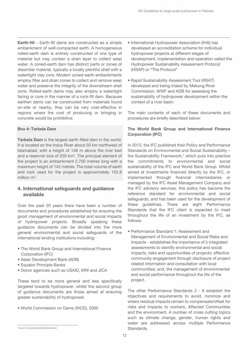
Box 4: Tarbela Dam
Tarbela Dam is the largest earth-filled dam in the world. It is located on the Indus River about 50 km northwest of Islamabad, with a height of 148 m above the river bed and a reservoir size of 250 km2. The principal element of the project is an embankment 2,700 metres long with a maximum height of 142 metres. The total volume of earth and rock used for the project is approximately 152.8 million m3.
4. International safeguards and guidance available
Over the past 20 years there have been a number of documents and procedures established for ensuring the good management of environmental and social impacts of hydropower projects. Broadly speaking these guidance documents can be divided into the more general environmental and social safeguards of the international lending institutions including:
• The World Bank Group and International Finance Corporation (IFC)• Asian Development Bank (ADB)• Equator Principle Banks• Donor agencies such as USAID, KfW and JICA
These tend to be more general and less specifically targeted towards hydropower, whilst the second group of guidance documents are those aimed at ensuring greater sustainability of hydropower.
• World Commission on Dams (WCD), 2000
EIA Guidelines for large-scale hydropower in Pakistan
• International Hydropower Association (IHA) has developed an accreditation scheme for individual hydropower projects at different stages of development, implementation and operation called the Hydropower Sustainability Assessment Protocol (HSAP) or “The Protocol”
• Rapid Sustainability Assessment Tool (RSAT) developed and being trialed by Mekong River Commission, WWF and ADB for assessing the sustainability of hydropower development within the context of a river basin.
The main contents of each of these documents and procedures are briefly described below:
The World Bank Group and International Finance Corporation (IFC)
In 2012, the IFC published their Policy and Performance Standards on Environmental and Social Sustainability – the Sustainability Framework,4 which puts into practice the commitments to environmental and social sustainability of the IFC and World Bank Group. Whilst aimed at investments financed directly by the IFC, or implemented through financial intermediaries or managed by the IFC Asset Management Company and the IFC advisory services, this policy has become the reference standard for environmental and social safeguards, and has been used for the development of these guidelines. There are eight Performance Standards that the IFC client is expected to meet throughout the life of an investment by the IFC, as follows:
• Performance Standard 1: Assessment and Management of Environmental and Social Risks and Impacts - establishes the importance of i) integrated assessments to identify environmental and social impacts, risks and opportunities of projects; effective community engagement through disclosure of project related information and consultation with local communities; and, the management of environmental and social performance throughout the life of the project.
The other Performance Standards 2 - 8 establish the objectives and requirements to avoid, minimize and where residual impacts remain to compensate/offset for risks and impacts to workers, Affected Communities and the environment. A number of cross cutting topics such as climate change, gender, human rights and water are addressed across multiple Performance Standards.4www.ifc.org/sustainabilityframework
• International Hydropower Association (IHA) has developed an accreditation scheme for individual hydropower projects at different stages of development, implementation and operation called the Hydropower Sustainability Assessment Protocol (HSAP) or “The Protocol”
• Rapid Sustainability Assessment Tool (RSAT) developed and being trialed by Mekong River Commission, WWF and ADB for assessing the sustainability of hydropower development within the context of a river basin.
The main contents of each of these documents and procedures are briefly described below:
The World Bank Group and International Finance Corporation (IFC)
In 2012, the IFC published their Policy and Performance Standards on Environmental and Social Sustainability – the Sustainability Framework,4 which puts into practice the commitments to environmental and social sustainability of the IFC and World Bank Group. Whilst aimed at investments financed directly by the IFC, or implemented through financial intermediaries or managed by the IFC Asset Management Company and the IFC advisory services, this policy has become the reference standard for environmental and social safeguards, and has been used for the development of these guidelines. There are eight Performance Standards that the IFC client is expected to meet throughout the life of an investment by the IFC, as follows:
• Performance Standard 1: Assessment and Management of Environmental and Social Risks and Impacts - establishes the importance of i) integrated assessments to identify environmental and social impacts, risks and opportunities of projects; effective community engagement through disclosure of project related information and consultation with local communities; and, the management of environmental and social performance throughout the life of the project.
The other Performance Standards 2 - 8 establish the objectives and requirements to avoid, minimize and where residual impacts remain to compensate/offset for risks and impacts to workers, Affected Communities and the environment. A number of cross cutting topics such as climate change, gender, human rights and water are addressed across multiple Performance Standards.
13
• Performance Standard 4: Community Health, Safety, and Security• Performance Standard 5: Land Acquisition and Involuntary Resettlement• Performance Standard 6: Biodiversity Conservation and Sustainable Management of Living Natural Resources• Performance Standard 7: Indigenous Peoples• Performance Standard 8: Cultural Heritage
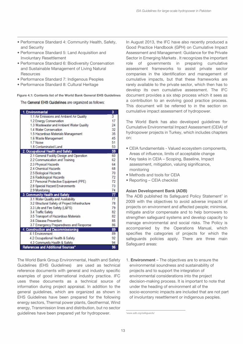
The World Bank Group Environmental, Health and Safety Guidelines (EHS Guidelines) are used as technical reference documents with general and industry specific examples of good international industry practice. IFC uses these documents as a technical source of information during project appraisal. In addition to the general guidelines, which are organized as shown in EHS Guidelines have been prepared for the following energy sectors, Thermal power plants, Geothermal, Wind energy, Transmission lines and distribution, but no sector guidelines have been prepared yet for hydropower.
EIA Guidelines for large-scale hydropower in Pakistan
In August 2013, the IFC have also recently produced a Good Practice Handbook (GPH) on Cumulative Impact Assessment and Management: Guidance for the Private Sector in Emerging Markets . It recognizes the important role of governments in preparing cumulative assessment frameworks to assist private sector companies in the identification and management of cumulative impacts, but that these frameworks are rarely available to the private sector, which then has to develop its own cumulative assessment. The IFC document provides a six step process which it sees as a contribution to an evolving good practice process. This document will be referred to in the section on cumulative impact assessment of hydropower.
The World Bank has also developed guidelines for Cumulative Environmental Impact Assessment (CEIA) of hydropower projects in Turkey, which includes chapters on:
• CEIA fundamentals - Valued ecosystem components, Areas of influence, limits of acceptable change• Key tasks in CEIA – Scoping, Baseline, Impact assessment, mitigation, valuing significance, monitoring• Methods and tools for CEIA• Reporting – CEIA checklist
Asian Development Bank (ADB)The ADB published its Safeguard Policy Statement7 in 2009 with the objectives to avoid adverse impacts of projects on environment and affected people; minimise, mitigate and/or compensate and to help borrowers to strengthen safeguard systems and develop capacity to manage environmental and social risks. The Policy is accompanied by the Operations Manual, which specifies the categories of projects for which the safeguards policies apply. There are three main Safeguard areas:
1. Environment – The objectives are to ensure the environmental soundness and sustainability of projects and to support the integration of environmental considerations into the project decision-making process. It is important to note that under the heading of environment all of the socio-economic impacts are included that are not part of involuntary resettlement or indigenous peoples.
Figure 4.1: Contents list of the World Bank General EHS Guidelines
7www.adb.org/safeguards/
In August 2013, the IFC have also recently produced a Good Practice Handbook (GPH) on Cumulative Impact Assessment and Management: Guidance for the Private Sector in Emerging Markets . It recognizes the important role of governments in preparing cumulative assessment frameworks to assist private sector companies in the identification and management of cumulative impacts, but that these frameworks are rarely available to the private sector, which then has to develop its own cumulative assessment. The IFC document provides a six step process which it sees as a contribution to an evolving good practice process. This document will be referred to in the section on cumulative impact assessment of hydropower.
The World Bank has also developed guidelines for Cumulative Environmental Impact Assessment (CEIA) of hydropower projects in Turkey, which includes chapters on:
• CEIA fundamentals - Valued ecosystem components, Areas of influence, limits of acceptable change• Key tasks in CEIA – Scoping, Baseline, Impact assessment, mitigation, valuing significance, monitoring• Methods and tools for CEIA• Reporting – CEIA checklist
Asian Development Bank (ADB)The ADB published its Safeguard Policy Statement7 in 2009 with the objectives to avoid adverse impacts of projects on environment and affected people; minimise, mitigate and/or compensate and to help borrowers to strengthen safeguard systems and develop capacity to manage environmental and social risks. The Policy is accompanied by the Operations Manual, which specifies the categories of projects for which the safeguards policies apply. There are three main Safeguard areas:
1. Environment – The objectives are to ensure the environmental soundness and sustainability of projects and to support the integration of environmental considerations into the project decision-making process. It is important to note that under the heading of environment all of the socio-economic impacts are included that are not part of involuntary resettlement or indigenous peoples.
14
2. Involuntary resettlement – the objectives are to avoid involuntary resettlement wherever possible; to minimize involuntary resettlement by exploring project and design alternatives; to enhance, or at least restore, the livelihoods of all displaced persons in real terms relative to pre-project levels; and to improve standards of living of the displaced poor and other vulnerable groups. Involuntary resettlement covers a) physical displacement (relocation, loss of residential land, or loss of shelter and b) economic displacement (loss of land, assets, access to assets, income sources or means of livelihoods as a result of involuntary acquisition of land or involuntary restrictions on land use or on access to legally designated parks and protected areas. 3. Indigenous peoples – the objectives are to design and implement projects in a way that fosters full respect for Indigenous peoples identity, dignity, human rights, livelihood systems and cultural uniqueness as defined by the Indigenous Peoples themselves so that they receive culturally appropriate social and economic benefits and do not suffer adverse impacts as a result of projects and can participate actively in projects that affect them.
In addition to advice on the requirements of the safeguard policy, the ADB safeguard policy statement includes outlines for the different reports – Environmental Impact Assessment Report, Resettlement Plan and Indigenous Peoples Plan.
Equator Principle BanksThe Equator Principles were adopted in 2003 by 10 of the world’s leading commercial banks in order to move towards a common and coherent set of environmental and social policies and guidelines to be applied globally and across all sectors. They were revised in 2006 to reflect and be consistent with the IFC’s Performance Standards. 78 Equator Principles Financial Institutions (EPFIs) in 35 countries have officially adopted the EPs, covering over 70 percent of international Project Finance debt in emerging markets.
They apply to all project financing with a capital cost of more than 10 million USD. The Equator Principles provide a risk management framework for financial institutions to determine, assess and manage environmental and social risk in projects. They are intended to provide a minimum standard for due diligence to support responsible risk decision-making. The EP apply globally, to all industry sectors and to four financial products:
EIA Guidelines for large-scale hydropower in Pakistan
1. Project Finance Advisory Services 2. Project Finance 3. Project-Related Corporate Loans 4. Bridge Loans
For all Category A and Category B Projects, the EPFI will require the client to conduct an assessment process to address, to the EPFI’s satisfaction, the relevant environmental and social risks and impacts of the proposed project. The Assessment Documentation should propose measures to minimise, mitigate, and offset adverse impacts in a manner relevant and appropriate to the nature and scale of the proposed Project.
Donor agenciesDonor agencies supporting hydropower projects in Pakistan, e.g. USAID, KfW, JICA tend to use safeguard standards that are similar to the IFC safeguard policy.
World Commission on Dams8
Brokered by the World Bank and the World Conservation Union (IUCN), the World Commission on Dams (WCD) was established in May 1998 in response to the escalating local and international controversies over large dams. It was mandated to:
• review the development effectiveness of large dams and assessed alternatives for water resources and energy development; and
• develop internationally acceptable criteria, guidelines and standards for the planning, design, appraisal, construction, operation, monitoring and decommissioning of dams.
The World Commission on Dams published its final report, entitled Dams and Development: a new framework for decision-making, in November 2000. The report is widely acknowledged as a significant contribution to the debate on dams, not only on the benefits and costs of large dams, but more generally to the current rethinking of development decision-making in a world deeply affected by rapid global change. In particular, its recommendation that decisions on major infrastructure developments take place within a framework that recognizes the rights of all stakeholders, and the risks that each stakeholder group is asked, or obliged to sustain, has been regarded as shifting the dams debate onto a new plane.
8http://www.unep.org/dams/WCD/
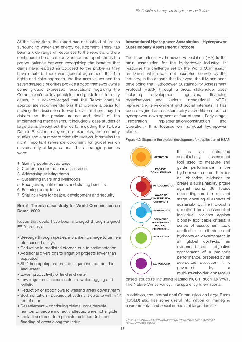
1. Project Finance Advisory Services 2. Project Finance 3. Project-Related Corporate Loans 4. Bridge Loans
For all Category A and Category B Projects, the EPFI will require the client to conduct an assessment process to address, to the EPFI’s satisfaction, the relevant environmental and social risks and impacts of the proposed project. The Assessment Documentation should propose measures to minimise, mitigate, and offset adverse impacts in a manner relevant and appropriate to the nature and scale of the proposed Project.
Donor agenciesDonor agencies supporting hydropower projects in Pakistan, e.g. USAID, KfW, JICA tend to use safeguard standards that are similar to the IFC safeguard policy.
World Commission on Dams8
Brokered by the World Bank and the World Conservation Union (IUCN), the World Commission on Dams (WCD) was established in May 1998 in response to the escalating local and international controversies over large dams. It was mandated to:
• review the development effectiveness of large dams and assessed alternatives for water resources and energy development; and
• develop internationally acceptable criteria, guidelines and standards for the planning, design, appraisal, construction, operation, monitoring and decommissioning of dams.
The World Commission on Dams published its final report, entitled Dams and Development: a new framework for decision-making, in November 2000. The report is widely acknowledged as a significant contribution to the debate on dams, not only on the benefits and costs of large dams, but more generally to the current rethinking of development decision-making in a world deeply affected by rapid global change. In particular, its recommendation that decisions on major infrastructure developments take place within a framework that recognizes the rights of all stakeholders, and the risks that each stakeholder group is asked, or obliged to sustain, has been regarded as shifting the dams debate onto a new plane.
15
At the same time, the report has not settled all issues surrounding water and energy development. There has been a wide range of responses to the report and there continues to be debate on whether the report struck the proper balance between recognizing the benefits that dams have realized as opposed to the problems they have created. There was general agreement that the rights and risks approach, the five core values and the seven strategic priorities provide a good framework while some groups expressed reservations regarding the Commission's policy principles and guidelines. In many cases, it is acknowledged that the Report contains appropriate recommendations that provide a basis for moving the discussion forward, even if there may be debate on the precise nature and detail of the implementing mechanisms. It included 7 case studies of large dams throughout the world, including the Tarbela Dam in Pakistan, many smaller examples, three country studies and a number of thematic reviews. It remains the most important reference document for guidelines on sustainability of large dams. The 7 strategic priorities were:
1. Gaining public acceptance2. Comprehensive options assessment3. Addressing existing dams4. Sustaining rivers and livelihoods5. Recognising entitlements and sharing benefits6. Ensuring compliance7. Sharing rivers for peace, development and security
Box 5: Tarbela case study for World Commission on Dams, 2000
Issues that could have been managed through a good ESIA process:
• Seepage through upstream blanket, damage to tunnels etc. caused delays• Reduction in predicted storage due to sedimentation• Additional diversions to irrigation projects lower than expected• Shift in cropping patterns to sugarcane, cotton, rice and wheat• Lower productivity of land and water• Low irrigation efficiencies due to water logging and salinity• Reduction of flood flows to wetland areas downstream• Sedimentation – advance of sediment delta to within 14 km of dam• Resettlement – continuing claims, considerable number of people indirectly affected were not eligible• Lack of sediment to replenish the Indus Delta and flooding of areas along the Indus
EIA Guidelines for large-scale hydropower in Pakistan
International Hydropower Association – Hydropower Sustainability Assessment Protocol
The International Hydropower Association (IHA) is the main association for the hydropower industry. In response the challenge set by the World Commission on Dams, which was not accepted entirely by the industry, in the decade that followed, the IHA has been developing the Hydropower Sustainability Assessment Protocol (HSAP) through a broad stakeholder base including development agencies, financing organisations and various international NGOs representing environment and social interests. It has been designed as a sustainability accreditation tool for hydropower development at four stages - Early stage, Preparation, Implementation/construction and Operation.9 It is focused on individual hydropower plants.
9See more at: http://www.hydrosustainability.org/Protocol.aspx#sthash.rSisycKf.dpuf10ICOLD www.icold-cigb.org
Figure 4.2: Stages in the project development for application of HSAP
It is an enhanced sustainability assessment tool used to measure and guide performance in the hydropower sector. It relies on objective evidence to create a sustainability profile against some 20 topics depending on the relevant stage, covering all aspects of sustainability. The Protocol is a method for assessment of individual projects against globally applicable criteria; a series of assessment tools applicable to all stages of hydropower development in all global contexts; an evidence-based objective assessment of a project's performance, prepared by an accredited assessor. It is governed by a multi-stakeholder, consensus
based structure including leading NGOs, such as WWF, The Nature Conservancy, Transparency International.
In addition, the International Commission on Large Dams (ICOLD) also has some useful information on managing environmental and social impacts of large dams.10
OPERATION
PREPARATION
EARLY STAGE
BACKGROUND
IMPLEMENTATION
PROJECTCOMMISSIONING
AWARD OFCONSTRUCTION
CONTRACTS
COMMENCEHYDROPOWER
PROJECTPREPARATION
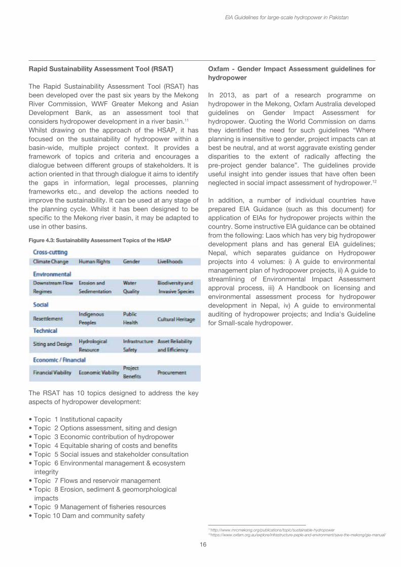
16
Rapid Sustainability Assessment Tool (RSAT)
The Rapid Sustainability Assessment Tool (RSAT) has been developed over the past six years by the Mekong River Commission, WWF Greater Mekong and Asian Development Bank, as an assessment tool that considers hydropower development in a river basin.11
Whilst drawing on the approach of the HSAP, it has focused on the sustainability of hydropower within a basin-wide, multiple project context. It provides a framework of topics and criteria and encourages a dialogue between different groups of stakeholders. It is action oriented in that through dialogue it aims to identify the gaps in information, legal processes, planning frameworks etc., and develop the actions needed to improve the sustainability. It can be used at any stage of the planning cycle. Whilst it has been designed to be specific to the Mekong river basin, it may be adapted to use in other basins.
The RSAT has 10 topics designed to address the key aspects of hydropower development:
• Topic 1 Institutional capacity• Topic 2 Options assessment, siting and design• Topic 3 Economic contribution of hydropower• Topic 4 Equitable sharing of costs and benefits• Topic 5 Social issues and stakeholder consultation • Topic 6 Environmental management & ecosystem integrity• Topic 7 Flows and reservoir management• Topic 8 Erosion, sediment & geomorphological impacts• Topic 9 Management of fisheries resources• Topic 10 Dam and community safety
EIA Guidelines for large-scale hydropower in Pakistan
Oxfam - Gender Impact Assessment guidelines for hydropower
In 2013, as part of a research programme on hydropower in the Mekong, Oxfam Australia developed guidelines on Gender Impact Assessment for hydropower. Quoting the World Commission on dams they identified the need for such guidelines “Where planning is insensitive to gender, project impacts can at best be neutral, and at worst aggravate existing gender disparities to the extent of radically affecting the pre-project gender balance”. The guidelines provide useful insight into gender issues that have often been neglected in social impact assessment of hydropower.12
In addition, a number of individual countries have prepared EIA Guidance (such as this document) for application of EIAs for hydropower projects within the country. Some instructive EIA guidance can be obtained from the following: Laos which has very big hydropower development plans and has general EIA guidelines; Nepal, which separates guidance on Hydropower projects into 4 volumes: i) A guide to environmental management plan of hydropower projects, ii) A guide to streamlining of Environmental Impact Assessment approval process, iii) A Handbook on licensing and environmental assessment process for hydropower development in Nepal, iv) A guide to environmental auditing of hydropower projects; and India's Guideline for Small-scale hydropower.
11http://www.mrcmekong.org/publications/topic/sustainable-hydropower 12https://www.oxfam.org.au/explore/infrastructure-peple-and-environment/save-the-mekong/gia-manual/
Figure 4.3: Sustainability Assessment Topics of the HSAP
17
5. Legal requirements for EIAs in Pakistan
5.1 Environmental Progress in Pakistan
The concept of sustainable development emerged in the past decades aims to develop a new framework for economic and social development, while maintaining the environmental and ecological integrity for the present as well as future generations. The history of environmental studies for the development projects dates back to the National Environmental Policy Act of the United States of America (NEPA) in 1969 (Glasson et al.1999). Following the US initiative, several countries implemented EIA systems, for example Australia (1974), Thailand (1975), France (1976), Philippines (1978), Israel (1981) and Pakistan (1983). It shows that in developing countries, the Asian countries started taking environmental measures very early, with many countries having an EIA system in place by the 1980s. The formalized arrangements for implementation of EIA system in Pakistan evolved over a period of fifteen years. It started with the promulgation of Pakistan Environmental Protection Ordinance (PEPO) of 1983 (repealed in 1997). EIA became mandatory for all new projects, since July 1, 1994. Documentation of sectoral guidelines as EIA Package is effective from 1997. Enactment of Pakistan Environmental Protection Act, 1997 in 2000 followed by government notification IEE/EIA Regulations, 2000. Finally, the National Environmental Policy in 2005, which describes integration of environment into development planning through implementation of EIA at project level and promotion of strategic environmental assessment (SEA) as a tool for integrating environment into decision-making process.
This section provides an overview of the policy framework and national legislation related to environment in the country with details on Initial Environmental Assessment (IEE) and Environmental Impact Assessment (EIA) regulation. The environmental law of the country provides standards and guidelines as basis for selection of appropriate pollution prevention/mitigation/control/disposal measures.
EIA Guidelines for large-scale hydropower in Pakistan
5.2 Constitutional Provision
5.2.1 Prior 18th Amendment
Before the 18th Amendment in the constitution of Pakistan, the legislative powers were with federal parliament and legislative assemblies of four provinces of Pakistan. The fourth schedule of the constitution provided two lists of subjects. One is Federal Legislative List, which includes sub subjects on which federal government has legislative powers. The second is Concurrent Legislative List which includes subject on which both federal and provincial government has legislative powers. If a particular legislation passed by the provincial assembly came into conflict with a law enacted by the national assembly, then according to constitution, the federal legislation will prevail over provincial legislation to extend the inconsistency.
The subject of environmental pollution and ecology were in Concurrent Legislative List of the constitution thus allowing both federal and provincial government to enact laws on this subject. However only federal government has enacted laws on environment and the provincial environmental institutions derived their power from federal law. Article 9 of the constitution defines the right of life as fundamental rights in these words, “No person shall be deprived of life or liberty save in accordance with law.”
5.2.2 Post 18th Amendment
After the 18th Amendment in 2010, the concurrent list has been abolished and a limited number of subjects on the list have been included in the federal legislative list, whereas, the provincial governments have been given powers to legislate on the subjects transferred to provinces. The provision of the 18th Amendment which has a direct impact on the subject of 'Environment' is section 101(3), whereby the Concurrent Legislative List and the entries thereto from 1 to 47 (both inclusive) have been omitted from the Fourth Schedule. The power to legislate and decide on the subject of “environmental pollution and ecology” now lies with the provincial government. The following subjects remain under federal jurisdiction:
Part 2 - Background
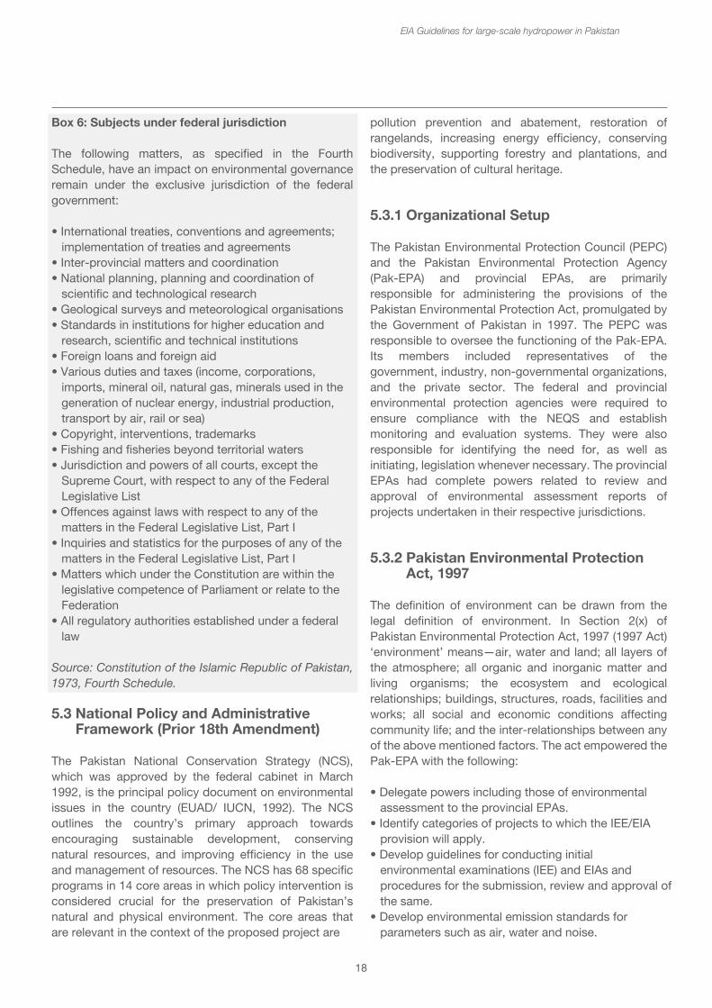
18
Box 6: Subjects under federal jurisdiction
The following matters, as specified in the Fourth Schedule, have an impact on environmental governance remain under the exclusive jurisdiction of the federal government:
• International treaties, conventions and agreements; implementation of treaties and agreements• Inter-provincial matters and coordination• National planning, planning and coordination of scientific and technological research• Geological surveys and meteorological organisations• Standards in institutions for higher education and research, scientific and technical institutions• Foreign loans and foreign aid• Various duties and taxes (income, corporations, imports, mineral oil, natural gas, minerals used in the generation of nuclear energy, industrial production, transport by air, rail or sea)• Copyright, interventions, trademarks• Fishing and fisheries beyond territorial waters• Jurisdiction and powers of all courts, except the Supreme Court, with respect to any of the Federal Legislative List• Offences against laws with respect to any of the matters in the Federal Legislative List, Part I• Inquiries and statistics for the purposes of any of the matters in the Federal Legislative List, Part I• Matters which under the Constitution are within the legislative competence of Parliament or relate to the Federation• All regulatory authorities established under a federal law
Source: Constitution of the Islamic Republic of Pakistan, 1973, Fourth Schedule.
5.3 National Policy and Administrative Framework (Prior 18th Amendment)
The Pakistan National Conservation Strategy (NCS), which was approved by the federal cabinet in March 1992, is the principal policy document on environmental issues in the country (EUAD/ IUCN, 1992). The NCS outlines the country’s primary approach towards encouraging sustainable development, conserving natural resources, and improving efficiency in the use and management of resources. The NCS has 68 specific programs in 14 core areas in which policy intervention is considered crucial for the preservation of Pakistan’s natural and physical environment. The core areas that are relevant in the context of the proposed project are
EIA Guidelines for large-scale hydropower in Pakistan
pollution prevention and abatement, restoration of rangelands, increasing energy efficiency, conserving biodiversity, supporting forestry and plantations, and the preservation of cultural heritage.
5.3.1 Organizational Setup
The Pakistan Environmental Protection Council (PEPC) and the Pakistan Environmental Protection Agency (Pak-EPA) and provincial EPAs, are primarily responsible for administering the provisions of the Pakistan Environmental Protection Act, promulgated by the Government of Pakistan in 1997. The PEPC was responsible to oversee the functioning of the Pak-EPA. Its members included representatives of the government, industry, non-governmental organizations, and the private sector. The federal and provincial environmental protection agencies were required to ensure compliance with the NEQS and establish monitoring and evaluation systems. They were also responsible for identifying the need for, as well as initiating, legislation whenever necessary. The provincial EPAs had complete powers related to review and approval of environmental assessment reports of projects undertaken in their respective jurisdictions.
5.3.2 Pakistan Environmental Protection Act, 1997
The definition of environment can be drawn from the legal definition of environment. In Section 2(x) of Pakistan Environmental Protection Act, 1997 (1997 Act) ‘environment’ means—air, water and land; all layers of the atmosphere; all organic and inorganic matter and living organisms; the ecosystem and ecological relationships; buildings, structures, roads, facilities and works; all social and economic conditions affecting community life; and the inter-relationships between any of the above mentioned factors. The act empowered the Pak-EPA with the following:
• Delegate powers including those of environmental assessment to the provincial EPAs.• Identify categories of projects to which the IEE/EIA provision will apply.• Develop guidelines for conducting initial environmental examinations (IEE) and EIAs and procedures for the submission, review and approval of the same.• Develop environmental emission standards for parameters such as air, water and noise.
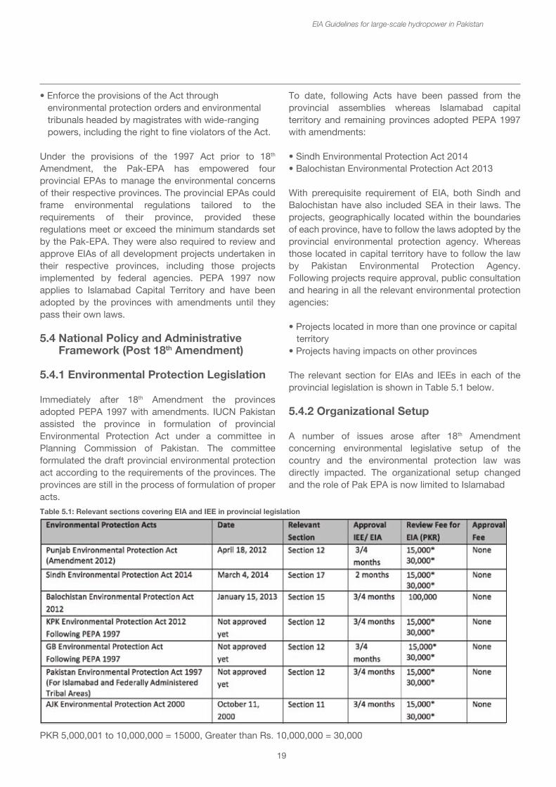
19
• Enforce the provisions of the Act through environmental protection orders and environmental tribunals headed by magistrates with wide-ranging powers, including the right to fine violators of the Act.
Under the provisions of the 1997 Act prior to 18th Amendment, the Pak-EPA has empowered four provincial EPAs to manage the environmental concerns of their respective provinces. The provincial EPAs could frame environmental regulations tailored to the requirements of their province, provided these regulations meet or exceed the minimum standards set by the Pak-EPA. They were also required to review and approve EIAs of all development projects undertaken in their respective provinces, including those projects implemented by federal agencies. PEPA 1997 now applies to Islamabad Capital Territory and have been adopted by the provinces with amendments until they pass their own laws.
5.4 National Policy and Administrative Framework (Post 18th Amendment)
5.4.1 Environmental Protection Legislation
Immediately after 18th Amendment the provinces adopted PEPA 1997 with amendments. IUCN Pakistan assisted the province in formulation of provincial Environmental Protection Act under a committee in Planning Commission of Pakistan. The committee formulated the draft provincial environmental protection act according to the requirements of the provinces. The provinces are still in the process of formulation of proper acts.
EIA Guidelines for large-scale hydropower in Pakistan
To date, following Acts have been passed from the provincial assemblies whereas Islamabad capital territory and remaining provinces adopted PEPA 1997 with amendments:
• Sindh Environmental Protection Act 2014• Balochistan Environmental Protection Act 2013
With prerequisite requirement of EIA, both Sindh and Balochistan have also included SEA in their laws. The projects, geographically located within the boundaries of each province, have to follow the laws adopted by the provincial environmental protection agency. Whereas those located in capital territory have to follow the law by Pakistan Environmental Protection Agency. Following projects require approval, public consultation and hearing in all the relevant environmental protection agencies:
• Projects located in more than one province or capital territory• Projects having impacts on other provinces
The relevant section for EIAs and IEEs in each of the provincial legislation is shown in Table 5.1 below.
5.4.2 Organizational Setup
A number of issues arose after 18th Amendment concerning environmental legislative setup of the country and the environmental protection law was directly impacted. The organizational setup changed and the role of Pak EPA is now limited to Islamabad
Table 5.1: Relevant sections covering EIA and IEE in provincial legislation
PKR 5,000,001 to 10,000,000 = 15000, Greater than Rs. 10,000,000 = 30,000
To date, following Acts have been passed from the provincial assemblies whereas Islamabad capital territory and remaining provinces adopted PEPA 1997 with amendments:
• Sindh Environmental Protection Act 2014• Balochistan Environmental Protection Act 2013
With prerequisite requirement of EIA, both Sindh and Balochistan have also included SEA in their laws. The projects, geographically located within the boundaries of each province, have to follow the laws adopted by the provincial environmental protection agency. Whereas those located in capital territory have to follow the law by Pakistan Environmental Protection Agency. Following projects require approval, public consultation and hearing in all the relevant environmental protection agencies:
• Projects located in more than one province or capital territory• Projects having impacts on other provinces
The relevant section for EIAs and IEEs in each of the provincial legislation is shown in Table 5.1 below.
5.4.2 Organizational Setup
A number of issues arose after 18th Amendment concerning environmental legislative setup of the country and the environmental protection law was directly impacted. The organizational setup changed and the role of Pak EPA is now limited to Islamabad
20
capital territory. The provincial environmental protection councils and the Pakistan Environmental Protection Agency and provincial EPAs, are primarily responsible for administering the provisions of the provincial environmental protection acts. Following is the existing organizational setup for implementation of the environmental laws in the country:
• Pakistan Environmental Protection Agency (capital territory)• Punjab Environmental Protection Agency • Sindh Environmental Protection Agency• Khyber Pakhtunkhwa Environmental Protection Agency • Balochistan Environmental Protection Agency • AJK Environmental Protection Agency• Gilgit-Baltistan Environmental Protection Agency
Federal agency now lacks the power to approve the EIA of the projects falling in more than one province. The proponents have to take approval from each province prior to construction. The agency cannot influence and regulate the provinces in the subject of environment. The role of Pakistan environmental protection council has become irrelevant and has been revised to provincial environmental protection council with members from provincial government.
5.4.3 Law Related Regulations and Guidance
The rules and regulations under the PEPA 1997 have been adopted by the provinces. The provinces intend to update the related regulation and guidance according to their environmental requirements and sensitivities. Existing IEE/EIA Regulation, NEQS, rules and Guidelines for Environmental Assessments notified by Pak-EPA are currently being used for compliance. It includes the set of EIA guidelines prepared by the federal and provincial environmental protection agencies. The rules and regulations under the provincial laws are being formulated to replace the existing standards. These aim to improve the country’s environment and ensure compliance to EIA integration in to development projects. The proponents have to meet the requirements of the relevant environmental protection agency prior to filing an IEE and EIA. The proponents must identify forthcoming advancement in environmental laws and compliance requirements of each province by meeting the regulators prior to start of IEE/EIA process.
5.4.4 Interdepartmental Coordination
The proponents of the projects are responsible for ensuring the project complies with the laws and regulations controlling the environmental concerns.
EIA Guidelines for large-scale hydropower in Pakistan
For that purpose, liaison with following departments shall be ensured: Federal and Provincial EPA - The proponents are responsible for providing the complete environmental documentation required by the Environmental Protection Agencies and remain committed to the approved project design. No deviation is permitted during project implementation without the prior and explicit permission of the EPAs concerned. Provincial Revenue Department - Under the national law, matters relating to land use and ownership are provincial subjects, and the revenue department of the province concerned is empowered to carry out the acquisition of private land or built-up property for public purposes, including on behalf of another provincial or federal agency. For this purpose, the lead department must lodge an application with the provincial government concerned to depute a land acquisition collector (LAC) and other revenue staff who will be responsible for handling matters related to acquisition and the disbursement of compensation. The proponents need to liaise with the provincial departments of agriculture, horticulture, and forestry in order to evaluate affected vegetation resources, such as trees and crops, etc., for compensation purposes.
Provincial Government - The projects must ensure to meet the criteria of the provincial government as related to the safe disposal of wastewater, solid waste, and toxic materials. The proponents have to coordinate and monitor environment-related issues.
5.4.5 Environment related Statutes
This section outlines statutes apart from the Pakistan Environmental Protection Act, 1997, which are relevant to the IEE and EIA of the proposed projects.
Antiquities Act, 1975 - The Antiquities Act relates to the protection, preservation and conservation of archaeological/historical sites and monuments. It prohibits construction (or any other damaging) activity within 200 m of such sites unless prior permission is obtained from the Federal Department of Archaeology and Museums. The Antiquities Act also binds the project proponents to notify the department should anything of archaeological value be excavated during project construction.
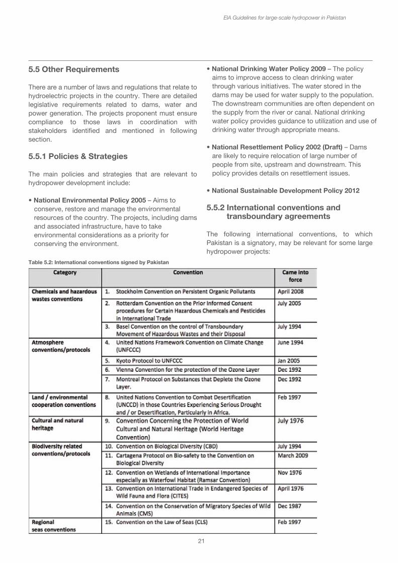
21
5.5 Other Requirements
There are a number of laws and regulations that relate to hydroelectric projects in the country. There are detailed legislative requirements related to dams, water and power generation. The projects proponent must ensure compliance to those laws in coordination with stakeholders identified and mentioned in following section.
5.5.1 Policies & Strategies
The main policies and strategies that are relevant to hydropower development include:
• National Environmental Policy 2005 – Aims to conserve, restore and manage the environmental resources of the country. The projects, including dams and associated infrastructure, have to take environmental considerations as a priority for conserving the environment.
EIA Guidelines for large-scale hydropower in Pakistan
• National Drinking Water Policy 2009 – The policy aims to improve access to clean drinking water through various initiatives. The water stored in the dams may be used for water supply to the population. The downstream communities are often dependent on the supply from the river or canal. National drinking water policy provides guidance to utilization and use of drinking water through appropriate means.
• National Resettlement Policy 2002 (Draft) – Dams are likely to require relocation of large number of people from site, upstream and downstream. This policy provides details on resettlement issues.
• National Sustainable Development Policy 2012
5.5.2 International conventions and transboundary agreements
The following international conventions, to which Pakistan is a signatory, may be relevant for some large hydropower projects:
Table 5.2: International conventions signed by Pakistan
• National Drinking Water Policy 2009 – The policy aims to improve access to clean drinking water through various initiatives. The water stored in the dams may be used for water supply to the population. The downstream communities are often dependent on the supply from the river or canal. National drinking water policy provides guidance to utilization and use of drinking water through appropriate means.
• National Resettlement Policy 2002 (Draft) – Dams are likely to require relocation of large number of people from site, upstream and downstream. This policy provides details on resettlement issues.
• National Sustainable Development Policy 2012
5.5.2 International conventions and transboundary agreements
The following international conventions, to which Pakistan is a signatory, may be relevant for some large hydropower projects:
22
Pakistan is not yet a signatory of the 1991 Espoo Convention on Environmental Impact Assessment in a Transboundary Context. This is a modern dynamic international treaty, designed to adapt to changing and more complex circumstances (Koivurova and Pölönen 2010). It was negotiated under the auspices of the United Nations Economic Commission for Europe (UNECE) and signed in Espoo, Finland, in 1991. The Convention entered into force in 1997, while the SEA Protocol to the Convention was signed in 2003. Kazakistan, Kyrgystan, Tajikistan and Russia are Parties to the Espoo Convention, and Uzbekistan is preparing to ratify (Maarsden 2011).
The Espoo Convention regulates situations where a significant adverse transboundary impact is likely to be caused to a state’s environment by a proposed activity in another contracting state (the origin state). The Convention requires the parties to cooperate with each other before the activity is undertaken. In order for this procedure to function effectively, the Espoo Convention requires the states to establish national EIA procedures that allow for the integration of foreign impacts and foreign stakeholders. The origin state is first required to notify the potentially affected state of the likely significant adverse transboundary impact and to provide basic information regarding the proposed activity. The affected state must next confirm that it wants to participate in the procedure. The origin state is then obligated to study the transboundary impacts together with the affected state and allow the public of that state to participate in the process on the same terms as its own public would be entitled to. After the EIA, the affected state has an opportunity through consultations with the origin state to comment on the proposed activity. The final decision taken on the proposed activity in the origin state must take due account of the comments from the potentially affected state and its public. A note prepared by the Espoo Convention Secretariat lists (inter alia) the following examples of “complex activities”:
• Pipelines, roads or other linear infrastructure projects that are part of an energy or transport network crossing several Parties;
• Large energy projects that could affect sub-regional policies.
EIA Guidelines for large-scale hydropower in Pakistan
Indus Water Treaty, 1960
There is one transboundary agreement with India negotiated in 1960. Eighty percent of Pakistan's output comes from the Indus Basin. Pakistan has one of the world’s largest canal systems built much before Independence by the British. After Independence, problems between the two countries arose over the distribution of water. Rivers flow into Pakistan territory from across India. In 1947, when Punjab was divided between the two countries, many of the canal head-works remained with India. The division of Punjab thus created major problems for irrigation in Pakistan. On April 1, 1948, India stopped the supply of water to Pakistan from every canal flowing from India to Pakistan. Pakistan protested and India finally agreed on an interim agreement on May 4, 1948. This agreement was not a permanent solution; therefore, Pakistan approached the World Bank in 1952 to help settle the problem permanently.
Negotiations were carried out between the two countries through the offices of the World Bank. It was finally in Ayub Khan’s regime that an agreement was signed between India and Pakistan in September 1960. This agreement is known as the Indus Water Treaty. This treaty divided the use of rivers and canals between the two countries. Pakistan obtained exclusive rights for the three western rivers, namely Indus, Jehlum and Chenab. And India retained rights to the three eastern rivers, namely Ravi, Beas and Sutluj. The treaty also guaranteed ten years of uninterrupted water supply. During this period Pakistan was to build huge dams, financed partly by long-term World Bank loans and compensation money from India. Three multipurpose dams, Warsak, Mangla and Tarbela were built. A system of eight link canals was also built, and the remodeling of existing canals was carried out. Five barrages and a gated siphon were also constructed under this treaty.13
1991 Water Apportionment Accord
In 1991, an agreement to share waters of the Indus River was reached between the four provinces of Pakistan in the form of the Water Apportionment Accord (WAA). This accord is based on both, the existing and future water needs of the four provinces. It protected the existing uses of canal water in each province and it apportions the balance of river supplies, including flood surpluses and future storage among the provinces.
13See more at: http://storyofpakistan.com/indus-water-treaty/#sthash
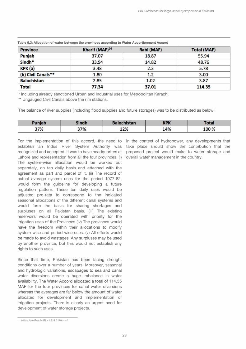
23
EIA Guidelines for large-scale hydropower in Pakistan
For the implementation of this accord, the need to establish an Indus River System Authority was recognized and accepted. It was to have headquarters at Lahore and representation from all the four provinces. (i) The system-wise allocation would be worked out separately, on ten daily basis and attached with the agreement as part and parcel of it. (ii) The record of actual average system uses for the period 1977-82, would form the guideline for developing a future regulation pattern. These ten daily uses would be adjusted pro-rata to correspond to the indicated seasonal allocations of the different canal systems and would form the basis for sharing shortages and surpluses on all Pakistan basis. (iii) The existing reservoirs would be operated with priority for the irrigation uses of the Provinces (iv) The provinces would have the freedom within their allocations to modify system-wise and period-wise uses. (v) All efforts would be made to avoid wastages. Any surpluses may be used by another province, but this would not establish any rights to such uses.
Since that time, Pakistan has been facing drought conditions over a number of years. Moreover, seasonal and hydrologic variations, escapages to sea and canal water diversions create a huge imbalance in water availability. The Water Accord allocated a total of 114.35 MAF for the four provinces for canal water diversions whereas the averages are far below the amount of water allocated for development and implementation of irrigation projects. There is clearly an urgent need for development of water storage projects.
In the context of hydropower, any developments that take place should show the contribution that the proposed project would make to water storage and overall water management in the country.
141 Million Acre Feet (MAF) = 1,233.5 Million m3
Table 5.3: Allocation of water between the provinces according to Water Apportionment Accord
* Including already sanctioned Urban and Industrial uses for Metropolitan Karachi.** Ungauged Civil Canals above the rim stations.
The balance of river supplies (including flood supplies and future storages) was to be distributed as below:
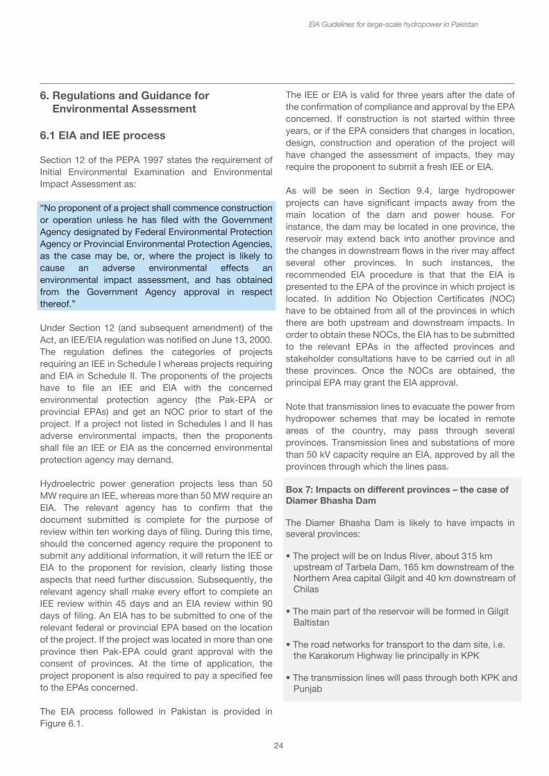
24
6. Regulations and Guidance for Environmental Assessment
6.1 EIA and IEE process
Section 12 of the PEPA 1997 states the requirement of Initial Environmental Examination and Environmental Impact Assessment as:
“No proponent of a project shall commence construction or operation unless he has filed with the Government Agency designated by Federal Environmental Protection Agency or Provincial Environmental Protection Agencies, as the case may be, or, where the project is likely to cause an adverse environmental effects an environmental impact assessment, and has obtained from the Government Agency approval in respect thereof.”
Under Section 12 (and subsequent amendment) of the Act, an IEE/EIA regulation was notified on June 13, 2000. The regulation defines the categories of projects requiring an IEE in Schedule I whereas projects requiring and EIA in Schedule II. The proponents of the projects have to file an IEE and EIA with the concerned environmental protection agency (the Pak-EPA or provincial EPAs) and get an NOC prior to start of the project. If a project not listed in Schedules I and II has adverse environmental impacts, then the proponents shall file an IEE or EIA as the concerned environmental protection agency may demand.
Hydroelectric power generation projects less than 50 MW require an IEE, whereas more than 50 MW require an EIA. The relevant agency has to confirm that the document submitted is complete for the purpose of review within ten working days of filing. During this time, should the concerned agency require the proponent to submit any additional information, it will return the IEE or EIA to the proponent for revision, clearly listing those aspects that need further discussion. Subsequently, the relevant agency shall make every effort to complete an IEE review within 45 days and an EIA review within 90 days of filing. An EIA has to be submitted to one of the relevant federal or provincial EPA based on the location of the project. If the project was located in more than one province then Pak-EPA could grant approval with the consent of provinces. At the time of application, the project proponent is also required to pay a specified fee to the EPAs concerned.
The EIA process followed in Pakistan is provided in Figure 6.1.
EIA Guidelines for large-scale hydropower in Pakistan
The IEE or EIA is valid for three years after the date of the confirmation of compliance and approval by the EPA concerned. If construction is not started within three years, or if the EPA considers that changes in location, design, construction and operation of the project will have changed the assessment of impacts, they may require the proponent to submit a fresh IEE or EIA.
As will be seen in Section 9.4, large hydropower projects can have significant impacts away from the main location of the dam and power house. For instance, the dam may be located in one province, the reservoir may extend back into another province and the changes in downstream flows in the river may affect several other provinces. In such instances, the recommended EIA procedure is that that the EIA is presented to the EPA of the province in which project is located. In addition No Objection Certificates (NOC) have to be obtained from all of the provinces in which there are both upstream and downstream impacts. In order to obtain these NOCs, the EIA has to be submitted to the relevant EPAs in the affected provinces and stakeholder consultations have to be carried out in all these provinces. Once the NOCs are obtained, the principal EPA may grant the EIA approval.
Note that transmission lines to evacuate the power from hydropower schemes that may be located in remote areas of the country, may pass through several provinces. Transmission lines and substations of more than 50 kV capacity require an EIA, approved by all the provinces through which the lines pass.
Box 7: Impacts on different provinces – the case of Diamer Bhasha Dam
The Diamer Bhasha Dam is likely to have impacts in several provinces:
• The project will be on Indus River, about 315 km upstream of Tarbela Dam, 165 km downstream of the Northern Area capital Gilgit and 40 km downstream of Chilas
• The main part of the reservoir will be formed in Gilgit Baltistan
• The road networks for transport to the dam site, i.e. the Karakorum Highway lie principally in KPK
• The transmission lines will pass through both KPK and Punjab
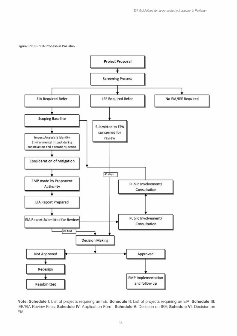
25
EIA Guidelines for large-scale hydropower in Pakistan
Figure 6.1: IEE/EIA Process in Pakistan
Note: Schedule I: List of projects requiring an IEE; Schedule II: List of projects requiring an EIA; Schedule III: IEE/EIA Review Fees; Schedule IV: Application Form; Schedule V: Decision on IEE; Schedule VI: Decision on EIA
26
• The changes in downstream water flow will affect communities in KPK, Punjab, and later as the Indus flows through Sindh
• There are expected to be benefits from increased irrigation water security downstream of the Tarbela Dam
• The sediment flows will be reduced thus increasing the life of Tarbela reservoir, but there may be an overall reduction in sediment transport to the Indus Delta in Sindh
The EIA has been prepared for approval by Gilgit Baltistan EPA. Stakeholder consultation meetings are envisaged for KPK, Punjab and Sindh and no objections to the EIA will be sought from the other provincial EPAs before final approval by Gilgit Baltistan EPA.
6.2 Guidelines for Environmental Assessment
The Pak-EPA has published a set of environmental guidelines for conducting environmental assessments and the environmental management of different types of development projects. The guidelines that are relevant to the hydropower projects are listed below, followed by comments on their relevance to the proposed project:
• Policy and Procedure for Filing review and approval of Environmental Assessments
• Guidelines for the Preparation and Review of Environmental Reports, Pakistan Environmental Protection Agency, 1997
• Guidelines for public consultation
• Guidelines for Sensitive and Critical Areas
A number of sector specific guidelines have been produced by the Pakistan EPA and some of the provincial EPAs. These are listed in Annex 3.
6.3 National Environmental Quality Standards
The hydroelectric power generation and dams project need to comply with the National Environmental Quality Standards (NEQS), 2000. NEQS specify the following standards:
EIA Guidelines for large-scale hydropower in Pakistan
• The National Environmental Quality Standards (NEQS) for municipal and liquid industrial effluent (Annexure 2)15
• NEQS for Industrial Gaseous Emission (Annexure 2) • NEQS for Vehicle Exhaust and Noise (Annexure 3)16
• NEQS for Ambient Air Quality (Annexure 4)17
• NEQS for Drinking Water Quality (Annexure 4)• NEQS for Noise (Annexure 4)
These standards also apply to the gaseous emissions and liquid effluents generated by generator, process waste etc. The standards for vehicles will apply during the construction as well as operation phase of the project.
6.4 Screening and EIA thresholds
Screening is the first step in the EIA process. The regulations are clear on what types and sizes of projects require the lesser Initial Environmental Examination (IEE) or full Environmental Impact Assessment (EIA).
If the project has an installed capacity of less than 50 MW or creates a reservoir with a storage volume of less than 50 million m3 or with a surface area of 8 km2, an IEE is required. However, if the project is located in or affects a designated environmentally sensitive area, then a full EIA is required, regardless of the size of the project. Transmission lines of between 11 kV and 50 kV require an IEE. Transmission lines over 50 kV and substations require full EIAs.
Box 8: Threshold for IEEs or EIAs for hydropower projects
Projects that require a full EIA • Hydroelectric power generation > 50 MW• Dams and reservoirs Storage Volume > 50 million m3
• Dams and reservoirs Surface Area > 8 km2
• Transmission lines and substations > 50 kv
Projects that may require an IEE only• Hydroelectric power generation < 50 MW• Dams and reservoirs Storage Volume < 50 million m3
• Dams and reservoirs Surface Area < 8 km2
• Transmission lines between 11 – 50 kv
Any project impacting on a critical or sensitive area will also require a full EIA
15http http://www.environment.gov.pk/NEQS/SRO549%20I2000-NEQS.pdf 16http://www.environment.gov.pk/NEQS/SRO%2072(KE)2009%20vehicle.pdf 17http://www.environment.gov.pk/NEQS/SRO-2010-NEQS%20Air-Water-Noise.pdf
• The National Environmental Quality Standards (NEQS) for municipal and liquid industrial effluent (Annexure 2)15
• NEQS for Industrial Gaseous Emission (Annexure 2) • NEQS for Vehicle Exhaust and Noise (Annexure 3)16
• NEQS for Ambient Air Quality (Annexure 4)17
• NEQS for Drinking Water Quality (Annexure 4)• NEQS for Noise (Annexure 4)
These standards also apply to the gaseous emissions and liquid effluents generated by generator, process waste etc. The standards for vehicles will apply during the construction as well as operation phase of the project.
6.4 Screening and EIA thresholds
Screening is the first step in the EIA process. The regulations are clear on what types and sizes of projects require the lesser Initial Environmental Examination (IEE) or full Environmental Impact Assessment (EIA).
If the project has an installed capacity of less than 50 MW or creates a reservoir with a storage volume of less than 50 million m3 or with a surface area of 8 km2, an IEE is required. However, if the project is located in or affects a designated environmentally sensitive area, then a full EIA is required, regardless of the size of the project. Transmission lines of between 11 kV and 50 kV require an IEE. Transmission lines over 50 kV and substations require full EIAs.
Box 8: Threshold for IEEs or EIAs for hydropower projects
Projects that require a full EIA • Hydroelectric power generation > 50 MW• Dams and reservoirs Storage Volume > 50 million m3
• Dams and reservoirs Surface Area > 8 km2
• Transmission lines and substations > 50 kv
Projects that may require an IEE only• Hydroelectric power generation < 50 MW• Dams and reservoirs Storage Volume < 50 million m3
• Dams and reservoirs Surface Area < 8 km2
• Transmission lines between 11 – 50 kv
Any project impacting on a critical or sensitive area will also require a full EIA
27
It is generally recognized that a large number of plants less than 50 MW have significant impacts, and though the threshold is specified as 50 MW, it is recommended that project proponents or their consultants should meet with the relevant authorities, e.g. EPAs, to discuss significance of the impacts and the need for a full EIA as early as possible in project development. There is a risk that if only an IEE is prepared, it may be sent back by the EPA if the impacts are considered significant, causing considerable delays in the obtaining an environmental compliance certificate.
Box 9: Inappropriateness of the 50 MW threshold
“An examination of HPP rankings based on their critical cumulative impacts on ecologically and socioeconomically sensitive zones shows that the majority of the top 20 HPPs in the ranking tables are less than 50 MW in size. This suggests that using the 50 MW generation capacity figure as the main determinant of environmental assessment standard is misguided. HPPs with capacities less than 50 MW but located in ecologically and socioeconomically sensitive zones do not necessarily exhibit a narrow range of environmental issues, and nor can the potential individual and cumulative impacts of these projects be understood and managed by the limited scope of analysis of IEEs.”
From: Strategic Environmental Assessment of Hydropower Development in Azad Jammu and Kashmir. Phase 3 Report - Informing Decision Making (2014)
EIA Guidelines for large-scale hydropower in Pakistan
7. Scoping to identify main environmental impacts
Scoping is the process of identifying what are likely to be the main environmental impacts. The analysis is not done in detail but it is important to identify the broad range of impacts. It is perhaps one of the most important parts of the process because it sets the focus for the whole EIA and can highlight the areas of study that will be required. It is most useful for defining and developing the Terms of Reference for the consultants undertaking the EIA.
Often scoping is carried out through both formal consultation meetings to hear what the concerns of the different groups of stakeholders are, and through focus group discussions and individual meetings with concerned people and organizations.
Sometimes the scoping phase can also include answering a questionnaire, which then triggers an awareness of what the main impacts might be. This section provides a checklist of questions designed to identify the topics for study, some questions will be easy to answer as being not appropriate for the type of hydropower scheme, for others there will not be enough information to be able to answer the question. If this is the case, then this indicates that the EIA should consider this issue, even though after the assessment the impact may be considered as insignificant. The scoping questionnaire is found in Annex 4.
The following questions are the same as the checklist questions. The cross-references allow the reader to go to the relevant narrative section which describes the importance/significance of the impact, how to describe it in the EIA report and possible mitigation or management measures.
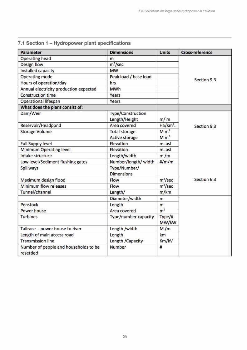
28
7.1 Section 1 – Hydropower plant specifications
EIA Guidelines for large-scale hydropower in Pakistan
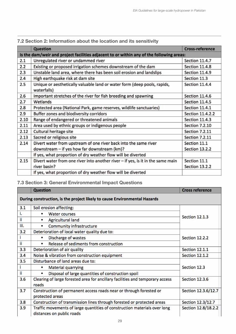
29
7.2 Section 2: Information about the location and its sensitivity
EIA Guidelines for large-scale hydropower in Pakistan
7.3 Section 3: General Environmental Impact Questions
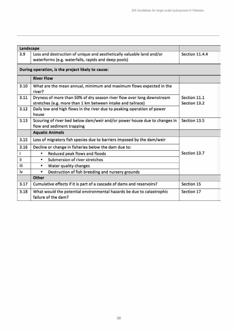
30
EIA Guidelines for large-scale hydropower in Pakistan
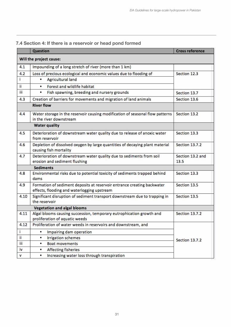
7.4 Section 4: If there is a reservoir or head pond formed
31
EIA Guidelines for large-scale hydropower in Pakistan
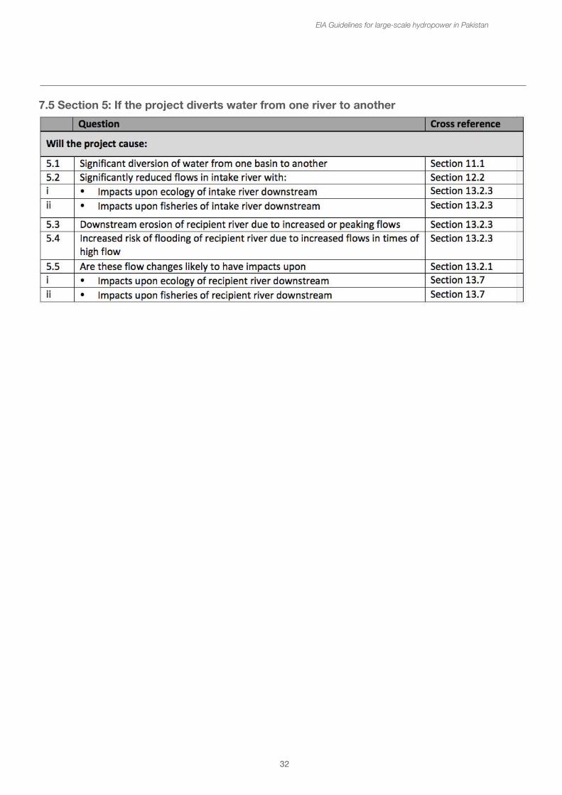
7.5 Section 5: If the project diverts water from one river to another
32
EIA Guidelines for large-scale hydropower in Pakistan
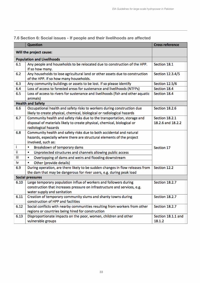
EIA Guidelines for large-scale hydropower in Pakistan
33
7.6 Section 6: Social issues - If people and their livelihoods are affected
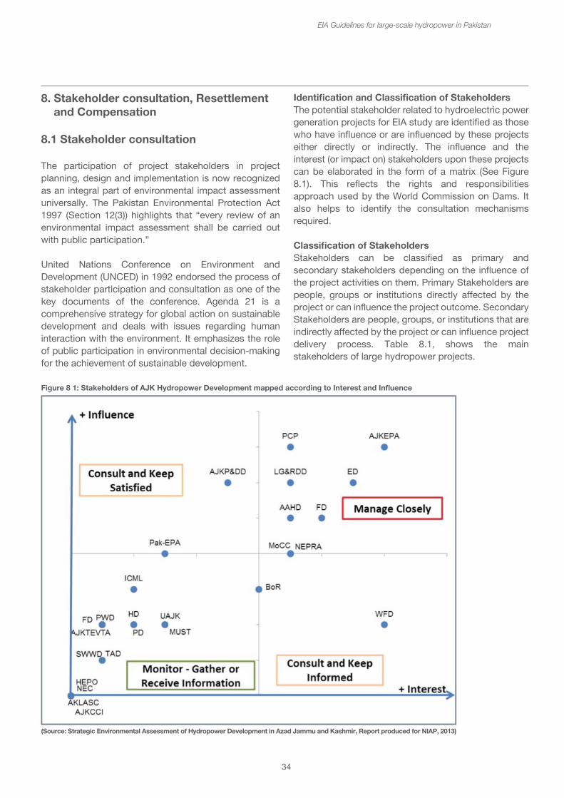
34
8. Stakeholder consultation, Resettlement and Compensation
8.1 Stakeholder consultation
The participation of project stakeholders in project planning, design and implementation is now recognized as an integral part of environmental impact assessment universally. The Pakistan Environmental Protection Act 1997 (Section 12(3)) highlights that “every review of an environmental impact assessment shall be carried out with public participation.”
United Nations Conference on Environment and Development (UNCED) in 1992 endorsed the process of stakeholder participation and consultation as one of the key documents of the conference. Agenda 21 is a comprehensive strategy for global action on sustainable development and deals with issues regarding human interaction with the environment. It emphasizes the role of public participation in environmental decision-making for the achievement of sustainable development.
EIA Guidelines for large-scale hydropower in Pakistan
Identification and Classification of StakeholdersThe potential stakeholder related to hydroelectric power generation projects for EIA study are identified as those who have influence or are influenced by these projects either directly or indirectly. The influence and the interest (or impact on) stakeholders upon these projects can be elaborated in the form of a matrix (See Figure 8.1). This reflects the rights and responsibilities approach used by the World Commission on Dams. It also helps to identify the consultation mechanisms required.
Classification of Stakeholders Stakeholders can be classified as primary and secondary stakeholders depending on the influence of the project activities on them. Primary Stakeholders are people, groups or institutions directly affected by the project or can influence the project outcome. Secondary Stakeholders are people, groups, or institutions that are indirectly affected by the project or can influence project delivery process. Table 8.1, shows the main stakeholders of large hydropower projects.
(Source: Strategic Environmental Assessment of Hydropower Development in Azad Jammu and Kashmir, Report produced for NIAP, 2013)
Figure 8 1: Stakeholders of AJK Hydropower Development mapped according to Interest and Influence
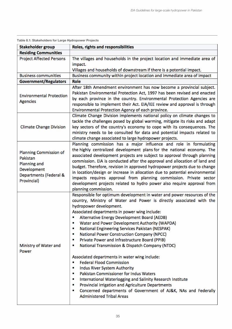
35
EIA Guidelines for large-scale hydropower in Pakistan
Table 8.1: Stakeholders for Large Hydropower Projects
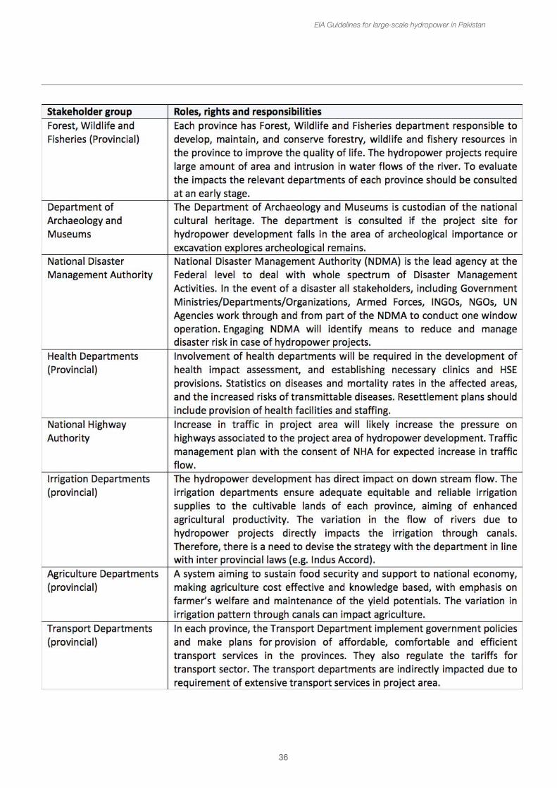
36
EIA Guidelines for large-scale hydropower in Pakistan
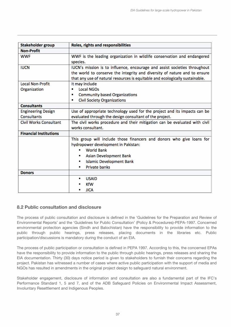
37
EIA Guidelines for large-scale hydropower in Pakistan
8.2 Public consultation and disclosure
The process of public consultation and disclosure is defined in the ‘Guidelines for the Preparation and Review of Environmental Reports’ and the ‘Guidelines for Public Consultation’ (Policy & Procedures)-PEPA-1997. Concerned environmental protection agencies (Sindh and Balochistan) have the responsibility to provide information to the public through public hearings, press releases, placing documents in the libraries etc. Public participation/discussions is mandatory during the conduct of an EIA.
The process of public participation or consultation is defined in PEPA 1997. According to this, the concerned EPAs have the responsibility to provide information to the public through public hearings, press releases and sharing the EIA documentation. Thirty (30) days notice period is given to stakeholders to furnish their concerns regarding the project. Pakistan has witnessed a number of cases where active public participation with the support of media and NGOs has resulted in amendments in the original project design to safeguard natural environment.
Stakeholder engagement, disclosure of information and consultation are also a fundamental part of the IFC’s Performance Standard 1, 5 and 7, and of the ADB Safeguard Policies on Environmental Impact Assessment, Involuntary Resettlement and Indigenous Peoples.
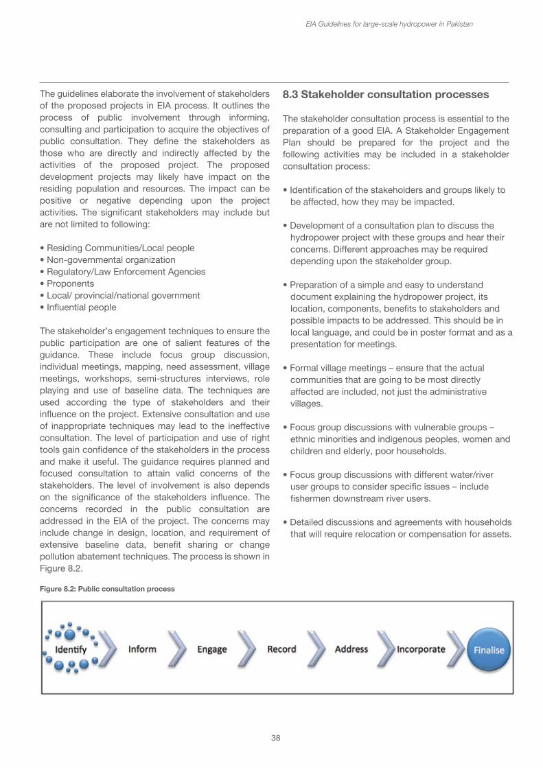
38
The guidelines elaborate the involvement of stakeholders of the proposed projects in EIA process. It outlines the process of public involvement through informing, consulting and participation to acquire the objectives of public consultation. They define the stakeholders as those who are directly and indirectly affected by the activities of the proposed project. The proposed development projects may likely have impact on the residing population and resources. The impact can be positive or negative depending upon the project activities. The significant stakeholders may include but are not limited to following:
• Residing Communities/Local people• Non-governmental organization• Regulatory/Law Enforcement Agencies• Proponents • Local/ provincial/national government • Influential people
The stakeholder’s engagement techniques to ensure the public participation are one of salient features of the guidance. These include focus group discussion, individual meetings, mapping, need assessment, village meetings, workshops, semi-structures interviews, role playing and use of baseline data. The techniques are used according the type of stakeholders and their influence on the project. Extensive consultation and use of inappropriate techniques may lead to the ineffective consultation. The level of participation and use of right tools gain confidence of the stakeholders in the process and make it useful. The guidance requires planned and focused consultation to attain valid concerns of the stakeholders. The level of involvement is also depends on the significance of the stakeholders influence. The concerns recorded in the public consultation are addressed in the EIA of the project. The concerns may include change in design, location, and requirement of extensive baseline data, benefit sharing or change pollution abatement techniques. The process is shown in Figure 8.2.
EIA Guidelines for large-scale hydropower in Pakistan
8.3 Stakeholder consultation processes
The stakeholder consultation process is essential to the preparation of a good EIA. A Stakeholder Engagement Plan should be prepared for the project and the following activities may be included in a stakeholder consultation process:
• Identification of the stakeholders and groups likely to be affected, how they may be impacted.
• Development of a consultation plan to discuss the hydropower project with these groups and hear their concerns. Different approaches may be required depending upon the stakeholder group.
• Preparation of a simple and easy to understand document explaining the hydropower project, its location, components, benefits to stakeholders and possible impacts to be addressed. This should be in local language, and could be in poster format and as a presentation for meetings.
• Formal village meetings – ensure that the actual communities that are going to be most directly affected are included, not just the administrative villages.
• Focus group discussions with vulnerable groups – ethnic minorities and indigenous peoples, women and children and elderly, poor households.
• Focus group discussions with different water/river user groups to consider specific issues – include fishermen downstream river users.
• Detailed discussions and agreements with households that will require relocation or compensation for assets.
Figure 8.2: Public consultation process
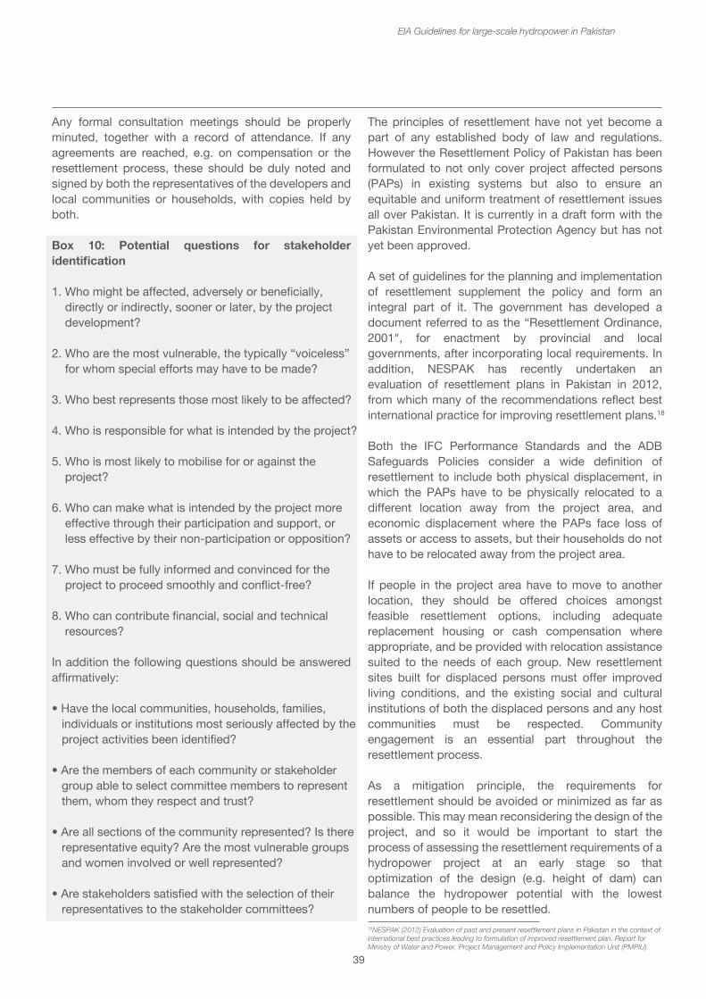
8.3 Stakeholder consultation processes
The stakeholder consultation process is essential to the preparation of a good EIA. A Stakeholder Engagement Plan should be prepared for the project and the following activities may be included in a stakeholder consultation process:
• Identification of the stakeholders and groups likely to be affected, how they may be impacted.
• Development of a consultation plan to discuss the hydropower project with these groups and hear their concerns. Different approaches may be required depending upon the stakeholder group.
• Preparation of a simple and easy to understand document explaining the hydropower project, its location, components, benefits to stakeholders and possible impacts to be addressed. This should be in local language, and could be in poster format and as a presentation for meetings.
• Formal village meetings – ensure that the actual communities that are going to be most directly affected are included, not just the administrative villages.
• Focus group discussions with vulnerable groups – ethnic minorities and indigenous peoples, women and children and elderly, poor households.
• Focus group discussions with different water/river user groups to consider specific issues – include fishermen downstream river users.
• Detailed discussions and agreements with households that will require relocation or compensation for assets.
39
Any formal consultation meetings should be properly minuted, together with a record of attendance. If any agreements are reached, e.g. on compensation or the resettlement process, these should be duly noted and signed by both the representatives of the developers and local communities or households, with copies held by both.
Box 10: Potential questions for stakeholder identification
1. Who might be affected, adversely or beneficially, directly or indirectly, sooner or later, by the project development?
2. Who are the most vulnerable, the typically “voiceless” for whom special efforts may have to be made?
3. Who best represents those most likely to be affected?
4. Who is responsible for what is intended by the project?
5. Who is most likely to mobilise for or against the project?
6. Who can make what is intended by the project more effective through their participation and support, or less effective by their non-participation or opposition?
7. Who must be fully informed and convinced for the project to proceed smoothly and conflict-free?
8. Who can contribute financial, social and technical resources?
In addition the following questions should be answered affirmatively:
• Have the local communities, households, families, individuals or institutions most seriously affected by the project activities been identified?
• Are the members of each community or stakeholder group able to select committee members to represent them, whom they respect and trust?
• Are all sections of the community represented? Is there representative equity? Are the most vulnerable groups and women involved or well represented?
• Are stakeholders satisfied with the selection of their representatives to the stakeholder committees?
EIA Guidelines for large-scale hydropower in Pakistan
The principles of resettlement have not yet become a part of any established body of law and regulations. However the Resettlement Policy of Pakistan has been formulated to not only cover project affected persons (PAPs) in existing systems but also to ensure an equitable and uniform treatment of resettlement issues all over Pakistan. It is currently in a draft form with the Pakistan Environmental Protection Agency but has not yet been approved.
A set of guidelines for the planning and implementation of resettlement supplement the policy and form an integral part of it. The government has developed a document referred to as the “Resettlement Ordinance, 2001", for enactment by provincial and local governments, after incorporating local requirements. In addition, NESPAK has recently undertaken an evaluation of resettlement plans in Pakistan in 2012, from which many of the recommendations reflect best international practice for improving resettlement plans.18
Both the IFC Performance Standards and the ADB Safeguards Policies consider a wide definition of resettlement to include both physical displacement, in which the PAPs have to be physically relocated to a different location away from the project area, and economic displacement where the PAPs face loss of assets or access to assets, but their households do not have to be relocated away from the project area.
If people in the project area have to move to another location, they should be offered choices amongst feasible resettlement options, including adequate replacement housing or cash compensation where appropriate, and be provided with relocation assistance suited to the needs of each group. New resettlement sites built for displaced persons must offer improved living conditions, and the existing social and cultural institutions of both the displaced persons and any host communities must be respected. Community engagement is an essential part throughout the resettlement process.
As a mitigation principle, the requirements for resettlement should be avoided or minimized as far as possible. This may mean reconsidering the design of the project, and so it would be important to start the process of assessing the resettlement requirements of a hydropower project at an early stage so that optimization of the design (e.g. height of dam) can balance the hydropower potential with the lowest numbers of people to be resettled. 18NESPAK (2012) Evaluation of past and present resettlement plans in Pakistan in the context of international best practices leading to formulation of improved resettlement plan. Report for Ministry of Water and Power, Project Management and Policy Implementation Unit (PMPIU)
40
All projects that involve resettlement will require a Resettlement Action Plan (RAP). The level and detail of the RAP will depend upon the number of PAPs and effect on their landholdings. Thus:
• Resettlement Action Plan will be required if more than 200 PAPs are affected or requires the acquisition of more than 20% of their landholdings.
• Abbreviated Resettlement Plan is there are less than 200 PAPs and requires the acquisition of less than 20% of the land holding.
• Resettlement Policy Framework, which is the first stage, required if the extent and location of resettlement is not yet known. This would lead into a full RAP at a later stage.
A number of resettlement management institutions have been proposed for projects at Federal level and provincial levels. Federally administered projects would work under the Pak-EPA, and private and provincial administered projects would work under the provincial EPAs. The resettlement management responsibilities of these resettlement steering councils would be to review the resettlement planning and implementation and give recommendations to the Ministry, ensure policy implementation, monitor the RAP implementation and deal with grievances. At the district level there should be a resettlement coordination council for the project responsible for resettlement planning and implementation, monitoring of implementation and operation, and for grievance redressal.19
Box 11: Reducing resettlement numbers through changing the design of Mangla dam raising
Mangla Dam was completed in 1967 on the Jhelum River with a total installed capacity of 1,150 MW and with an objective of strengthening the irrigation capacity of the country. The original dam was 138 m high and over 3 km long, with a reservoir of 251 km2 and storage capacity of 5,560 m3. Over 280 villages and the towns of Mirpur and Dadyal were submerged and over 110,000 people were displaced from the area. However, due to rapid sediment accumulation in the reservoir, over 25% of the active storage capacity had been lost by 2005.
The Mangla Dam Raising Project was started in 2004 and the main dam, spillway and its allied works were completed in 2009.
EIA Guidelines for large-scale hydropower in Pakistan
This project effectively raised the dam height by 9.15 m to 147 m. increasing the dam's storage capacity by an additional 3,551 million m3 to 9,111 million m3 and increased its installed capacity to 1,120 MW.
This raising of the dam affected about 44,000 people, 6388 hectares of land, with inundation of 8000 houses, economic values, livestock etc. These impacts were mitigated through a Resettlement Action Plan, which included a highly attractive and unprecedented compensation package. The main benefits include land/house compensation at market value and allotment of land for rebuilding houses in a new city and four towns, which are being developed with most modern infrastructure and basic amenities. The resettlement cost worked out to be about US$ 578 million, which was about 60% of the total cost of the project.
The feasibility study for raising the dam showed that raising it by 12 m would be technically feasible and economically viable. However, the incremental benefits of raising the dam from 9.15 m to 12.2 m are relatively small against substantial costs and displacement of population.
8.5 Compensation
The acquisition of private properties for public purposes including development projects in Pakistan is governed by the Land Acquisition Act 1894 (LAA). It comprises of 55 Sections pertaining to area notifications and surveys, acquisition, compensation and apportionment awards and disputes resolution, penalties and exemptions. Part VII of the act deals with acquisition of land for companies.
The IFC Performance Standard 5 also covers compensation stating that where displacement can not be avoided, compensation for loss of assets will be offered at full replacement costs together with other assistance to help them improve or restore their standards of living or livelihoods. Compensation standards should be transparent and applied consistently to all persons and communities affected.
The eligibility criteria for compensation are usually classified in three categories – i) those people having legal title to the affected land or assets that they occupy or use, ii) those who do not have formal legal rights to land or assets but have claims to the affected land that is recognized or recognizable under national law and
19Recommendations from NESPAK report (2012)
41
iii) those who have no legal right or claim to the land or assets they occupy or use. For PAPs in the first two categories, they should be entitled to compensation, and for those without legal rights they should be entitled to compensation except for the cost of the land. If they lose the structure of their livelihoods, they should be entitled to compensation.
The replacement cost rather than market value is preferred as a basis for compensation; replacement costs may involve market value, productive potential, all administrative fees and an inflation factor if the payment is delayed. Valuations should be based on market surveys and independent assessment, and not rely upon sale deeds which can be falsely over estimated, e.g. by sales between relatives.
Preference should be given to land-based resettlement, rather than cash payments. Land-based strategies for compensation should consider the productive potential, locational advantage and other factors that are at least equivalent to the land to be acquired. Cash based compensation may be adopted if livelihood is not affected and agricultural land is not involved, or if there is insufficient land which is suitable for livelihood restoration and if only a small proportion of the land to be acquired.
It is important to set a cut-off date for compensation, in order to discourage new people from coming in from outside the affected area to take advantage of the possibility of compensation. The IFC Performance Standard makes it clear that the developer is not required to compensate or assist opportunistic settlers who encroach on the project area after the cut-off date for eligibility. There should also an increment factor built into the compensation formula to discourage the time between surveys and actual displacement. The compensation formula should also include replacement/relocation mechanisms or values for graves, cultural properties and common resources, including community infrastructure, crops, trees and other assets.
Box 12: Outline for Resettlement Plan as per ADB Safeguards Policy
1. Executive summary2. Project description3. Scope of land acquisition and resettlement4. Socioeconomic information and profile5. Information disclosure, consultation and participation6. Grievance redress mechanisms7. Legal framework
EIA Guidelines for large-scale hydropower in Pakistan
8. Entitlements, Assistance and Benefits9. Relocation of housing and settlements10. Income restoration and rehabilitation11. Resettlement budget and financing plan12. Institutional arrangements13. Implementation schedule14. Monitoring and reporting
9. Guidance for completion of certain sections of EIAs
9.1 Structure of an EIA report
The structure of an EIA report usually follows a standard pattern. Performance Standard 1 of the IFC Sustainability Framework covers Assessment and Management of Environmental and Social Risks and Impacts (IFC, 2012) “underscores the importance of managing environmental and social impacts throughout the life of a project, and notes that an effective Environmental and Social Management System is a dynamic and continuous process initiated and supported by management and involves engagement between the client, its workers, local communities directly affected by the project and other stakeholders”. The Sustainability Framework provides details of the contents of the ESMS.
The ADB Safeguard Policy Statement (ADB, 2009) suggests that an EIA report should include the following sections:
A. Executive Summary
B. Policy, Legal and Administrative Framework – national, local legal and institutional framework, including project relevant international environmental agreements.
C. Description of the project – major components of the project and associated facilities (quarries, access roads, soil disposal sites). With maps and drawings to identify project layout and areas of influence.
D. Description of the Environment (Baseline data) – relevant physical, biological and socio-economic conditions. Current and proposed development activities within projects area of influence. Includes the accuracy, reliability and source of the data.
E. Anticipated Environmental Impacts and Mitigation measures – likely positive and negative direct and indirect impacts to physical, biological, socio-economic conditions.
42
The socio-economic includes occupational health and safety, vulnerable groups and gender issues and impacts on livelihoods through environmental media and physical cultural resources. Identifies mitigation measures and any residual negative impacts that cannot be mitigated. Examines global, transboundary and cumulative impacts as appropriate.
F. Analysis of Alternatives – examines the alternatives to the project, including the “no project alternative” including their impacts, feasibility of mitigation, capital and operating costs. It states the basis for selecting the particular project.
G. Information Disclosure, Consultation and Participation – describes the process undertaken for engaging stakeholders, including information disclosure and consultation. It summarises the comments received from affected people and other stakeholders and shows how these have been addressed. It describes the planned information disclosure and consultation processes to be used during project implementation.
H. Grievance Redress Mechanism – describes the grievance redress framework, both formal and informal channels, setting out time frame and mechanisms for resolving complaints about environmental performance.
I. Environmental Management Plan – describes the mitigation and management measures to be taken during project implementation. It should include a) mitigation, b) monitoring, c) implementation arrangements, d) performance indicators.
J. Conclusion and Recommendations
9.2 Consideration of alternatives for hydropower EIAs
The Pakistan EIA regulations specify that the EIA should consider alternatives to the project. The environmental and social impacts of the alternatives need not be described in such detail as the chosen project, but the section should illustrate the main environmental, social and economic differences of the compared alternatives, and clearly state the reasons why the preferred project has been selected. The section should only select a few alternatives to compare.
EIA Guidelines for large-scale hydropower in Pakistan
The Guidelines for the Preparation and Review of Environmental Reports20 indicates that alternatives may consider the following types of alternatives:
• Demand alternatives – this would show the need for the hydropower project in terms of meeting electricity demand and for irrigation (if appropriate). An alternative demand alternative might consider energy efficiency measures as a means of reducing the demand and hence the need for electricity. However, in Pakistan, such is the shortfall in power production, this is unlikely to be a realistic alternative.
• Activity alternatives – this would show a comparison with thermal power plants constructed to meet the demand for electricity. Thermal power plants are usually quicker and less costly to build but require a constant source of fuel (coal, gas or oil), which may be expensive and likely to become more costly. The big environmental impact comparison would be in terms of air pollution and greenhouse gas emissions. Although large hydropower does contribute some greenhouse gases (e.g. methane from the reservoir) these are likely to be an order of magnitude lower than a thermal power station.
• Locational alternatives – this would consider similar sizes of hydropower plant on different rivers or different locations on the same river. Each hydropower plant is different and choice of location may be an important environmental factor, for instance if a one alternative dam is located within a sensitive area (e.g. protected area) and another is further downstream outside of the area. Figure 9.1 shows some of the factors to be considered in the choice and comparison of alternative dams on a river system. Location alternatives may be a matter of a 10 km upstream or downstream so that the impacts, e.g. on area inundated or numbers of people to be resettled may be reduced.
20http://www.environment.gov.pk/eia_pdf/D_rev_enReprt.pdf
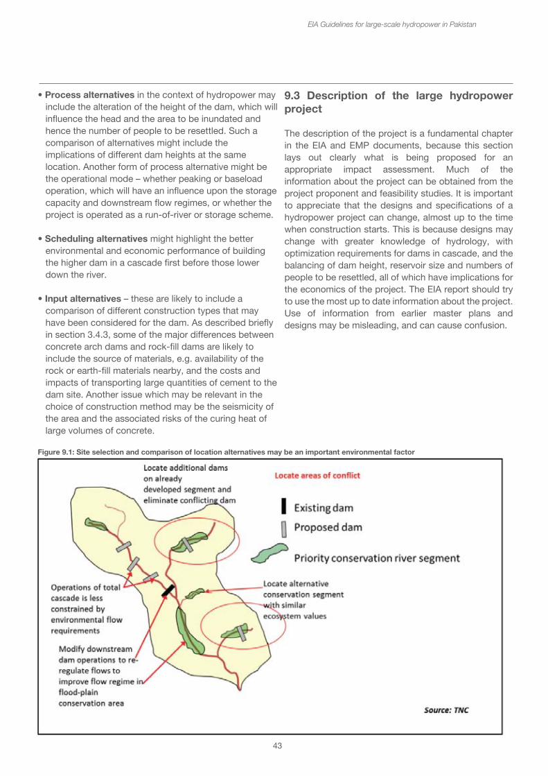
The Guidelines for the Preparation and Review of Environmental Reports20 indicates that alternatives may consider the following types of alternatives:
• Demand alternatives – this would show the need for the hydropower project in terms of meeting electricity demand and for irrigation (if appropriate). An alternative demand alternative might consider energy efficiency measures as a means of reducing the demand and hence the need for electricity. However, in Pakistan, such is the shortfall in power production, this is unlikely to be a realistic alternative.
• Activity alternatives – this would show a comparison with thermal power plants constructed to meet the demand for electricity. Thermal power plants are usually quicker and less costly to build but require a constant source of fuel (coal, gas or oil), which may be expensive and likely to become more costly. The big environmental impact comparison would be in terms of air pollution and greenhouse gas emissions. Although large hydropower does contribute some greenhouse gases (e.g. methane from the reservoir) these are likely to be an order of magnitude lower than a thermal power station.
• Locational alternatives – this would consider similar sizes of hydropower plant on different rivers or different locations on the same river. Each hydropower plant is different and choice of location may be an important environmental factor, for instance if a one alternative dam is located within a sensitive area (e.g. protected area) and another is further downstream outside of the area. Figure 9.1 shows some of the factors to be considered in the choice and comparison of alternative dams on a river system. Location alternatives may be a matter of a 10 km upstream or downstream so that the impacts, e.g. on area inundated or numbers of people to be resettled may be reduced.
43
EIA Guidelines for large-scale hydropower in Pakistan
Figure 9.1: Site selection and comparison of location alternatives may be an important environmental factor
9.3 Description of the large hydropower project
The description of the project is a fundamental chapter in the EIA and EMP documents, because this section lays out clearly what is being proposed for an appropriate impact assessment. Much of the information about the project can be obtained from the project proponent and feasibility studies. It is important to appreciate that the designs and specifications of a hydropower project can change, almost up to the time when construction starts. This is because designs may change with greater knowledge of hydrology, with optimization requirements for dams in cascade, and the balancing of dam height, reservoir size and numbers of people to be resettled, all of which have implications for the economics of the project. The EIA report should try to use the most up to date information about the project. Use of information from earlier master plans and designs may be misleading, and can cause confusion.
• Process alternatives in the context of hydropower may include the alteration of the height of the dam, which will influence the head and the area to be inundated and hence the number of people to be resettled. Such a comparison of alternatives might include the implications of different dam heights at the same location. Another form of process alternative might be the operational mode – whether peaking or baseload operation, which will have an influence upon the storage capacity and downstream flow regimes, or whether the project is operated as a run-of-river or storage scheme.
• Scheduling alternatives might highlight the better environmental and economic performance of building the higher dam in a cascade first before those lower down the river.
• Input alternatives – these are likely to include a comparison of different construction types that may have been considered for the dam. As described briefly in section 3.4.3, some of the major differences between concrete arch dams and rock-fill dams are likely to include the source of materials, e.g. availability of the rock or earth-fill materials nearby, and the costs and impacts of transporting large quantities of cement to the dam site. Another issue which may be relevant in the choice of construction method may be the seismicity of the area and the associated risks of the curing heat of large volumes of concrete.
44
In addition to the layout of the scheme, some of the key parameters about large hydropower projects that are important from an environmental and social perspective are:
Operating head (m) The operating head is the height difference between the forebay pond and the turbines in the power house. With the design flow, the capacity of the plant can be defined.
Design flow (m3/sec) The design flow is the volume of water required to run the turbines at capacity. It is the volume of water that will be diverted from the river through the channel to the power house.
Installed capacity (MW) The installed capacity is the designed electrical output of the HPP when operating at full load.
Operating mode - Peak load or Base load - The two forms of operating mode are usually peak or base load. Peak load refers to generation to meet the peak demand for electricity – usually during daylight hours. Base load refers to more or less continuous electricity production. This information will show the use of storage capacity in the headpond/reservoir, and the flows diverted through the turbines. With peak load, the flows will tend to be higher, compared to base load flows.
Hours of operation/day (Hours per day) If the plant is operated in peak load mode, it may be operated for 8 or 12 hours per day compared to base load which would run for 24 hours per day. In the dry season, when there is less water available, the plant may be operated at lower flows, or for a shorter time each day.
Annual electricity production expected (GWh/yr) The electricity production is the total amount of power produced in a year, taking into account the design capacity of the turbines with the total numbers of hours operated each year. If the plant is operated at lower than design flows, e.g. during the dry season, the electricity production would also be lower.
Construction time (Years) The construction time is the time taken for the plant to be built from initial site preparation to the start of commercial operation. It would include the initial testing of the plant.
EIA Guidelines for large-scale hydropower in Pakistan
Operational lifespan (Years) The operational lifespan of the plant is the expected life of the overall scheme. Often this is determined by the degree of siltation of the headpond or reservoir rather than the design life of mechanical and electrical equipment, since these can be replaced.
Component Specifications
Dam – Length (m) and Height (m) - The dimensions of the dam indicate the size of the project. The height may be important if fish passage is feasible.
Spillways – are used for allowing surplus and flood waters to pass downstream and to prevent over topping of the dam. The spillway should be designed to pass a recognized maximum flood (the design flood). The spillways range from simple, unregulated weir arrangements, to more complex mechanical gates that can be moved to release the surplus water. Specifications should include the design flood (cu.m/sec), the number, dimensions (width and height) and type of gates.
Reservoir/Headpond - Area covered (ha) - The reservoir or headpond will inundate an area of land, change the land use, and may cause loss of agricultural land, forest, and villages or households.
Full Supply Level and Minimum Operating Level – these are expressed as elevations above sea level (masl). The Full Supply Level (FSL) is the normal maximum level of the water in the reservoir. The Minimum Operating Level (MOL) is the lowest level to which the reservoir would be drawn down during low flow season. The difference between ML and FSL is known as the draw down, (expressed in metres). Note that the reservoir level may exceed that of FSL for example in the event of floods. The water in the reservoir may also be drawn down below the MOL, e.g. if the reservoir is being drained for sediment flushing from bottom gates, but in this case operation is no longer possible.
Storage Capacity – There are two measures of storage capacity 1) Total storage volume this is the total volume of water that can be stored in the reservoir 2) Active storage volume this is the volume of water which may be used for power generation and is the volume of water stored between the MOL and FSL.
45
Intake structure – The intake structure allows water to be taken off from the reservoir, delivered to the penstock and from there to the turbines. Often made of concrete and located in the reservoir, it may be set at a level just below the Minimum Operating Level, so that the turbines can continue to be operated down to MOL. If it is considered that there will be persistent water quality issues when water is drawn from lower levels, intakes with multiple level take-off points may be designed to ensure that better quality water is always taken from near the surface. In HPPs that divert water from one river to another, the intake structure may be in a completely different location on the reservoir to the main dam.
Bottom and Sediment flushing gates - Number of gates, Length (m) Width (m) - The bottom gates are used for draining the complete reservoir and would only be used very occasionally. Sediment flushing may also be done through the bottom gates, but special sediment flushing gates may also be built into the dam structure. These will be more effective at sediment flushing.
Tunnel or headrace channel Length (m) and Diameter or width (m) - The width of the channel is determined by the design flow required. The channel design tries to maintain the head between intake and power house. The length of the channel, whether around the hillside or tunneled through it, will indicate the size of the structure and hence its footprint. This will show the scale of project. The impact will be upon the landuse that the channel passes through. If a tunnel is required, there will be significant impacts related to disposal of waste rock and soil.
Penstock Length (m) The penstock is essentially a very large set of pipes that ensure uniform flows reaching the turbines. The penstock length from the intake to the power house is dependent upon the head. The design flow and the length will determine its footprint. If the power house is close to the dam, this may be built into the dam and associated structures. If the power house is at the end of a tunnel several kilometres away, the penstock may be a separate structure.
Power house - Area covered (m2) - The power house is the large building housing the turbines and control equipment. Its size will be determined by this equipment and structures (hoists etc.) required for maintenance, and any control offices and other facilities.
EIA Guidelines for large-scale hydropower in Pakistan
Turbines – Type, Number (#), Capacity (MW) - There are several types of turbines. Having more than one turbine allows more flexibility in operation, especially if the there is a big difference between dry and wet season water availability. The rated capacity of the turbines indicates the amount of power that can be generated when operated at full design flow.
Switchyard Area covered (m2) - The switchyard consists of the electricity substation and control structures through which the power is evacuated from the hydropower plant through to the transmission lines.
Tailrace - power house to river - Length (m), Width (m). The tailrace returns the water after the turbines to the river. The length and width of the tailrace channel depends upon the design flow and location of the power house in relation to the river.
Length of main access road Length (km) Access roads to reach the HPP together with roads to different parts of the system will need to be built in order to get construction materials and mechanical and electrical equipment to the site. Sometimes these can be long and pass through forests and protected areas. The length of the access road and its width may have important environmental impacts.
Transmission line Length (km) Capacity (kv) - As with the access road, the transmission line to take the power out from the HPP may be quite long and pass through forests and protected areas. The vegetation over 3 m high may have to be cleared within a corridor of up to 60 m, depending upon the capacity of the transmission line.
Numbers of people and households to be resettled Number (#) Households and people may have to be moved for both site works and for the reservoir or headpond. Some households may not need to be moved but will be affected by losing land and other assets. Distinguish between households that have to be relocated and those whose livelihoods are affected.
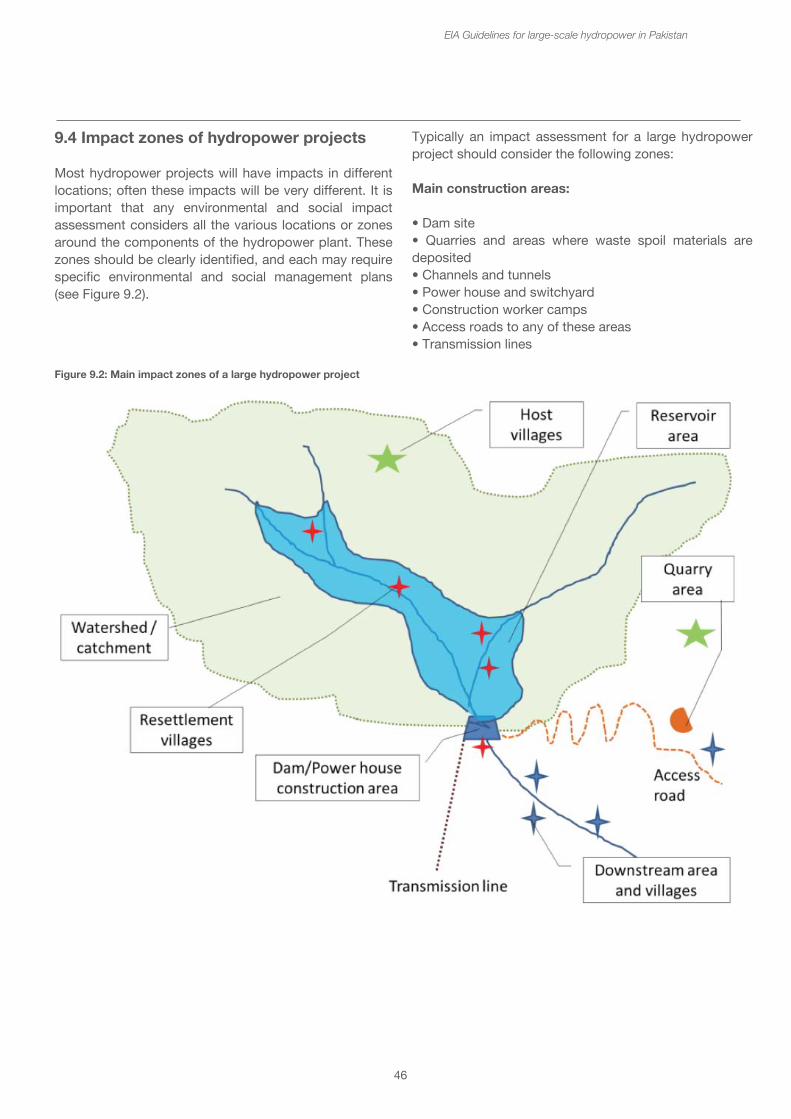
46
EIA Guidelines for large-scale hydropower in Pakistan
9.4 Impact zones of hydropower projects
Most hydropower projects will have impacts in different locations; often these impacts will be very different. It is important that any environmental and social impact assessment considers all the various locations or zones around the components of the hydropower plant. These zones should be clearly identified, and each may require specific environmental and social management plans (see Figure 9.2).
Typically an impact assessment for a large hydropower project should consider the following zones:
Main construction areas:
• Dam site • Quarries and areas where waste spoil materials are deposited• Channels and tunnels • Power house and switchyard • Construction worker camps• Access roads to any of these areas• Transmission lines
Figure 9.2: Main impact zones of a large hydropower project
47
Rivers• Reservoir area upstream of the dam that will be flooded
• Downstream areas, including:
- Stretches of river downstream of the power house that may have varying flows depending upon times of day of generation.
- Stretches of the river downstream of the dam affected by “dewatering” i.e. having less water than normal, e.g. the 63 km of Indus river downstream Tarbela which has been affected by the Ghazi-Barotha hydropower scheme.
- Stretches of river downstream of the power house in the case of interbasin transfers that will have more water than normal.
• Wider catchment or watershed for both watershed management (e.g. erosion and sediment management) and assessment of cumulative impacts.
Resettlement areas/host villages
• Reservoir area from which people may have to be relocated
• Resettlement areas and host villages
• Downstream economically affected communities
If resettlement and relocation of households is required, the areas where the people are moved from will need to be considered. This is usually the same as the reservoir area, or the construction sites. The impacts on the areas where people are moved to will also be important, including any host villages. The livelihoods of the people living in the downstream of the dam and the power house may also be affected. Even if they do not have to be physically relocated, these people are economically affected and should be included in a resettlement plan.
EIA Guidelines for large-scale hydropower in Pakistan
9.5 Phasing of large hydropower projects
The impacts of the phases of large hydropower projects are very different and need to be described clearly in the EIA. There are four main phases that can be distinguished:
1. Pre-construction which involves the geological and hydrological surveys, assessment of seismic risk, identification of quarrying materials, and baseline surveys of biological and social impacts. These may be quite environmentally and socially intrusive, but impacts are relatively localized and temporary. They are unlikely to be considered in the EIA process, but permissions to carry out such investigative activities will be subject to specific requirements.
2. Construction is likely to have the most obvious impacts, and have the greatest requirements for environmental and social management. Construction activities include the site preparations, quarrying, earthmoving, tunneling, disposal of waste spoil, construction of coffer dams and river diversions, laying of the foundations and concrete formwork. As the work progresses preparations for the filling of the reservoir may include removal of biomass from the area, and then river closure allowing the reservoir to start filling. The installation of the turbines and generators will require heavy mechanical and electrical work. In resettlement areas, there will be construction activities related to house building and provision of facilities such as roads, water, electricity and waste water treatment. The construction phase ends with the testing of the equipment before moving into commercial operation.
3. Operation activities will have very different environmental and social impacts. The principal impacts will derive from the changes in flow regime due to operation of the turbines, the storage of the water, accumulation of sediment and barrier effects of the dam and reservoir for fish. There may be additional flow and water quality impacts due to operation of the spillways and sediment flushing gates, as well as routine maintenance.
4. Closure this is the final phase and is likely to be very far in future – usually more than 50 years. It is difficult to provide an assessment of the impacts of closure because the conditions are likely to have changed significantly. However, it will be important to indicate the expected lifetime of the dam and reservoir, especially in terms of sediment build-up in the reservoir.
48
Box 13: Phases and activities of a large hydropower project
The activities of a SHPP project in the four phases will have different impacts. The principal activities in each phase may include:
Pre-construction
• Hydrological measurements• Topographic and geological, and seismic surveys• Baseline surveys for water quality and fisheries
Construction
• Provision of access and construction roads• Setting up of construction worker camps• Management and storage of construction materials• Disposal of solid and liquid wastes• Vehicle and equipment maintenance• Site clearance of vegetation and top soils• Clearance of vegetation in reservoir area• Provision of temporary coffer dams (if necessary) to divert the river• Earthmoving and blasting• Quarrying and transport of rock, sand and gravel• Concrete formworks• Laying of channels and pipes• Installation of mechanical and electrical equipment• Installation of switchyard and transmission lines
Operation
• Management of water flows for electricity generation • Diversion of water from one part of river further downstream• Diversion of water from one river to another• Removal of sediments from sediment trap and sediment flushing from reservoir • Routine maintenance of mechanical and electrical equipment• Hydrological and environmental monitoring• Safety inspections of civil works and equipment
Closure and decommissioning
• Indicate expected life of civil works, mechanical and electrical equipment• Indicate expected speed of sediment accumulation in reservoir storage capacity and life of HPP
• Indicate what would be the options at the end of HPP life for extension of the scheme or closure and decommissioning
EIA Guidelines for large-scale hydropower in Pakistan
• Note that since this is likely to be in more than 50 years, the options for extension or closure cannot be taken at this stage, and these will have their own environmental and social impact assessment.
9.6 Carrying out baseline surveys
One of the main sections of the EIA report is the description of the baseline situation, the physical, chemical, biological and social character and conditions which will be impacted. This is the starting point for the assessment. The description of the baseline is often one of the most poorly done sections of an EIA report, with considerable use of “cut and paste”. Whilst some of the data and a number of the more general descriptions can be gathered from existing information, reports and from the feasibility study of the project, it is essential that comprehensive baseline surveys for these different characteristics are carried out.
The TOR for the EIA should specify the detailed surveys to be undertaken, and these can be determined at the scoping stage. This will depend upon the character and sensitivity of the area, and the nature of the project activities. Existing information and earlier investigations will provide a basis for the design, but cannot replace the need for specific surveys. Some biological surveys may have to be undertaken at different seasons – e.g. high flow and low flow, or wet and dry seasons in order to get a picture of seasonal changes. Social surveys may be provide the necessary socio-economic information, but will have to be followed by detailed asset measurement and assessment on a household basis for determining compensation.
9.7 Impact assessment criteria
Environmental and social impacts should be assessed in a systematic manner. There are a number of ways of categorizing and assessing impacts, and each of the potential impacts should be described using the following criteria. Wherever possible, measured or estimated values should be used to justify the assignment in a particular category, but in some cases this will not be possible, in which case a more qualitative assessment may be used based on appropriate professional judgment.
49
• Direction – this indicates whether the impacts will be beneficial or adverse.
- Positive benefits, + ve - Negative impacts, - ve
• Magnitude – this indicates the size of the impact, and should be assessed relative to a recognizable unit, e.g. the impacts on agricultural land might be assessed relative to the total agricultural land in the surrounding area (district).
- Very High - High- Moderate - Low - Very Low
• Extent – this indicates where the impacts are distributed. There may be several dimensions to this, not all of which may be relevant.
- Local – any impacts only have an effect in the immediate surrounding area e.g. within the district.
- Provincial – any impacts that only have an effect upon the wider area within the province.
- National – any impacts that have inter-provincial or national importance.
- Regional – any impacts that might affect the wider South Asian or Central Asian region, e.g. water allocations and use.
- Global – any impacts that have a global importance, e.g. greenhouse gas emissions, or loss of globally important biodiversity.
• Temporary/Permanent – some impacts only last for a relatively short time, even if they are severe whilst they last. Many construction impacts, e.g. on water quality are likely to be temporary. In contrast, the inundation of agricultural land will be a permanent loss.
• Reversible/Irreversible – some impacts can be reversed afterwards, others are irreversible. For example, the visual impacts at the construction site, can be reversed through appropriate landscaping and planting after construction has been completed. The extirpation of a species from the area, because the habitat has been changed is likely to be irreversible.
EIA Guidelines for large-scale hydropower in Pakistan
Various methods have been proposed for presenting these impact assessments in a meaningful way to highlight the most significant impacts and the ones that need mitigation. These include various forms of impact matrix and numerical estimates with impact significance ranges such as the Rapid Impact Assessment Matrix (RIAM).
Risk assessment methods may be used when there is an element of uncertainty about the impact occurring. This is especially used for dam safety assessments, e.g. readiness to impound the reservoir or for assessing the risks of dam failure and emergency preparedness. Most often risk is assessed using the equation:
Risk = Probability of occurrence x Consequences
The probability of occurrence is often assessed qualitatively on a range between Very Low, Low, Moderate, High, Very High (or on a scale of 1 – 5), whilst the consequences if the impact occurs (which may be in terms of human life or economic losses of property and livelihood) may be also assessed qualitatively on a similar range from Very Low to Very High or numerical scale.
Assessment of residual impacts after mitigation - The EIA report and the EMP should show how the impacts that have been assessed may be managed and mitigated. Some of the impacts will be managed most effectively and will no longer be a problem, however, not all impacts can be completely managed, and some are inevitable. It is important that a statement is made about the residual impacts of the project that cannot be avoided, reduced or otherwise managed, towards the end of the EIA report and in the executive summary. This represents the overall impact of the project and may be the basis for compensation or offsetting.
Assessment of residual impacts after mitigation is often inadequately presented in an EIA report, and so extra attention needs to be paid to this.
9.8 EIA Tools and assessment methods
These guidelines do not prescribe the tools and assessment methods that the consultants may use to prepare the EIA or IEE. However, there are a number of very useful tools which make the assessment easier and which allow a clearer presentation to the reader and decision maker.
50
These include:
- GIS mapping of the impacted areas, showing:
• Locations of the components of the hydropower scheme
• Current river structure and the extent of the proposed reservoir and watershed
• Existing land use and forested areas
• Protected areas and other environmentally sensitive areas
• Towns and villages, including upstream, downstream and host communities for resettlement
• Roads and other infrastructure
- GIS analysis for estimating the areas impacted, including:
• Area inundated
• Areas of agricultural and forest land use inundated
• Areas of watershed or catchment with different management requirements
• Satellite imagery and aerial photography, which allows an appreciation of areas that may be very difficult to visit. In the absence of commissioned imagery, Google Earth provides an excellent first imaging tool, and even the geomorphology of the river can be assessed in this way.
• Ground based photography to show particular features of the landscape or infrastructure, housing and communities that need to be illustrated. Consultation meeting photographs etc.
• Hydrological modeling, which can supplement existing hydrological information, and allow projections of how the flow may be changed. There are free software models that allow a first cut at environmental flow and river health modeling, but more sophisticated models may have been used by the designers of the hydropower scheme to model reservoir operation etc.
EIA Guidelines for large-scale hydropower in Pakistan
• A variety of social survey methods from formal questionnaires, to structured and semi-structured interviews, which may be expressed in different graphic formats. These may be subjected to statistical social analysis.
• It would be very helpful to enumerate the assets to be compensated or replaced in a special database, which includes geographic coordinates.
This list does not preclude other old or new methods that illustrate or facilitate the assessment of the impacts.
10. Developing the EMP and monitoring
The Environmental Management Plan is one of the most important parts of the EIA process. It is also required for an IEE. The EMP should show how the impacts will be managed, and should form part of any contractual documents and agreements, so the measures will be legally binding and non-compliance enforceable. With the EIA, the EMP should be available on site for reference during construction and operation. Should changes in the EMP be required during the course of the project construction, it may be necessary to have these approved formally by the EPA with a compliance variation.
There is a recognized hierarchy of measures for managing environmental and social impacts. If the first type of measure cannot be used, then the next down the hierarchy should be applied. Thus avoidance is always better than reduction, which is preferred to rectification. When all else is not applicable, only then should compensation be considered.
1. Avoidance – this is where the impact is avoided, e.g. by locating the dam in a different place or with a different height, or by routing the transmission line so that it avoids an urban area, or a culturally sensitive site.
2. Reduction or minimization – this is where the magnitude of the negative impact is reduced either through the design or through management. For example, the height of the dam may be reduced so that the numbers of people that have to be resettled is lower than the original design. Similarly, the impacts of water pollution by sewage from the construction worker camps may be reduced by the installation of a waste water treatment plant. Erosion and sediment releases into the river due to earth moving may be reduced by following recognized best construction practices.
51
3. Rectification – this is where the temporary and reversible negative impacts are corrected or rectified after construction is finished. This would include landscaping, tree planting, erosion protection measures downstream of the power house.
4. Compensation – this is where the impact is recognised as inevitable and compensation is provided. Compensation may take the form of direct payments to people or businesses affected, e.g. for assets lost, or resettlement and the provision of new housing with the associated infrastructure. Compensation may also take the form of livelihoods programmes aiming at providing the resettled families with new forms of income generation and livelihoods, e.g. through financial loans and training schemes. Compensation for losses of biodiversity may take the form of watershed management for conservation, contributions to protected area management and recognized biodiversity offsets.
The EMP should systematically address all of the impacts that have been assessed, and show what measures will be taken and how they will be implemented. A budget should be proposed for carrying out these measures for the duration of the project during construction and operation. This budget for environmental and social measures should be incorporated into the overall costs of the project, together with an adequate contingency budget line. Quite often the budget for environmental and social costs is set too low for hydropower projects, with the result that the actual costs for impact management goes over budget; it is perhaps better to prepare more realistic budgets.
The EMP is a contractual obligation of the project proponent and would be incorporated into any concession agreements. These EMP obligations should be passed on to any contractors and their sub-contractors working on the dam or other components of the project. Some EMPs may also contain a contractor’s EMP that shows the environmental and social management measures that they are responsible for. It is also recognized that that hydropower projects change during the preparatory design phase, and so the EMP may also have to be updated before construction starts. A final and more detailed EMP for implementation may be prepared within six months of construction start.
EIA Guidelines for large-scale hydropower in Pakistan
In developing the EMPs it will be necessary to hold detailed consultations and reach agreements with local communities, because many plans will depend upon their cooperation and involvement for effective implementation, e.g. watershed and wildlife management, biomass removal, resettlement and community development. Appropriate costs to cover these should be included in the budget. The EIA and EMP may require more specific management and action plans which would be produced, depending upon the characteristics of the project, such as:
• Watershed Management Plan - this may include wildlife management in the catchment• Biomass Removal Plan• Resettlement Action Plan• Stakeholder Engagement Plan• Livelihood Restoration Plan• Community Development Plan• Vulnerable Groups Development Plan
An equally important part of the EMP is the section on monitoring and compliance. Key features for a monitoring programme for a hydropower project should include are:
• Water quality in the river downstream and upstream in the reservoir after impoundment• Solid waste management• Noise, dust and emissions around the construction site• Construction practices• Fish and fisheries in the river downstream and upstream in the reservoir• Biodiversity management measures, e.g. translocations of species• Resettlement processes, compensation payments• Effectiveness of livelihood programmes, e.g. increasing household income• Complaints and grievances and how they are addressed - Grievance redress mechanisms should be described in the EMP.
Monitoring details should be provided to include the methods, sampling sites and frequency of measurement, and any non-compliance thresholds. It should cover both the construction and operation phases, recognizing that the monitoring requirements may change in the different stages. The costs of the monitoring programme should also be estimated and included in the overall project budget.
52
Finally, the EMP should describe the institutional arrangements for environmental and social management. Many developers of large hydropower projects will establish their own environmental and social departments to manage the issues and carry out their own monitoring programmes. Smaller projects may choose not to have a separate department but include environmental and social management within the scope of work of the project and site managers. Whichever, they will be responsible for the regular reporting of progress (usually quarterly) of the environmental and social measures undertaken and any monitoring results.
The institutional arrangements should also describe the linkage with the regulatory authorities – the EPAs. Sometimes a specific environmental and social management committee may be set up to deal with the issues arising from the project consisting of the EPAs, the project proponent, the local authorities, community representatives, NGOs and other stakeholders. Such a committee would meet regularly and consider the issues raised in the environmental and social management progress and monitoring reports. A detailed outline of an EMP is provided in Annex 5.
EIA Guidelines for large-scale hydropower in Pakistan
Part 3 - Addressing environmental and social issues related to hydropowerIn this section the key environmental and social issues associated with hydropower will be covered. The significance of the issues will be described, followed by the information and methods that may be used for assessing the impacts and risks and lastly the options for mitigation and management of these impacts.
11 Key design issues
11.1 Hydrology
The hydrological character of the river is the most important piece of information required when determining the potential output of a hydropower plant and the subsequent choices of siting and design. The purpose of this section is not to describe the hydrological parameters for the design of a hydropower plant, but rather to highlight the features that need to be included in an EIA for an HPP.
The first aspect covers the water resource itself and its availability. This will depend upon the climate particularly the precipitation that falls on the catchment area above the dam site. This may take the form of rain, and snow and glacial melt depending upon the elevation of the catchment. The quantity of run-off reaching the river at the dam site will depend upon the size, slope and shape of the catchment area and the soils and groundwater infiltration. The temperature regime will determine the rate of evapotranspiration - all these factors will contribute to the overall water balance. It is thus important that the EIA report provides details on the climate and water balance in the catchment.
The surface water flowing in the streams and tributaries feeding into the main river from the catchment will vary depending upon the rainfall events. The flows in the river as near the dam site as possible should be measured over a number of years in order to understand the variability in the annual flows (e.g. the differences between very wet and very dry years), and the seasonal patterns of flow.
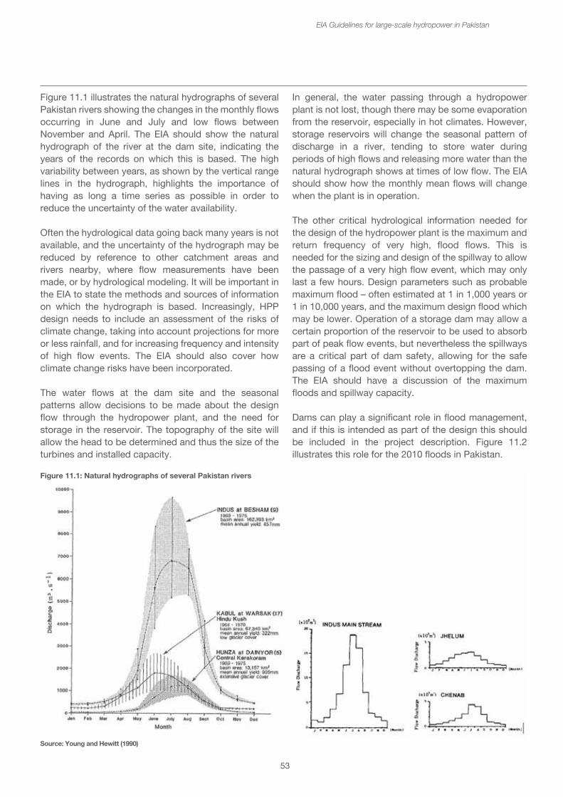
53
Figure 11.1 illustrates the natural hydrographs of several Pakistan rivers showing the changes in the monthly flows occurring in June and July and low flows between November and April. The EIA should show the natural hydrograph of the river at the dam site, indicating the years of the records on which this is based. The high variability between years, as shown by the vertical range lines in the hydrograph, highlights the importance of having as long a time series as possible in order to reduce the uncertainty of the water availability.
Often the hydrological data going back many years is not available, and the uncertainty of the hydrograph may be reduced by reference to other catchment areas and rivers nearby, where flow measurements have been made, or by hydrological modeling. It will be important in the EIA to state the methods and sources of information on which the hydrograph is based. Increasingly, HPP design needs to include an assessment of the risks of climate change, taking into account projections for more or less rainfall, and for increasing frequency and intensity of high flow events. The EIA should also cover how climate change risks have been incorporated.
The water flows at the dam site and the seasonal patterns allow decisions to be made about the design flow through the hydropower plant, and the need for storage in the reservoir. The topography of the site will allow the head to be determined and thus the size of the turbines and installed capacity.
EIA Guidelines for large-scale hydropower in Pakistan
In general, the water passing through a hydropower plant is not lost, though there may be some evaporation from the reservoir, especially in hot climates. However, storage reservoirs will change the seasonal pattern of discharge in a river, tending to store water during periods of high flows and releasing more water than the natural hydrograph shows at times of low flow. The EIA should show how the monthly mean flows will change when the plant is in operation.
The other critical hydrological information needed for the design of the hydropower plant is the maximum and return frequency of very high, flood flows. This is needed for the sizing and design of the spillway to allow the passage of a very high flow event, which may only last a few hours. Design parameters such as probable maximum flood – often estimated at 1 in 1,000 years or 1 in 10,000 years, and the maximum design flood which may be lower. Operation of a storage dam may allow a certain proportion of the reservoir to be used to absorb part of peak flow events, but nevertheless the spillways are a critical part of dam safety, allowing for the safe passing of a flood event without overtopping the dam. The EIA should have a discussion of the maximum floods and spillway capacity.
Dams can play a significant role in flood management, and if this is intended as part of the design this should be included in the project description. Figure 11.2 illustrates this role for the 2010 floods in Pakistan.
Figure 11.1: Natural hydrographs of several Pakistan rivers
Source: Young and Hewitt (1990)
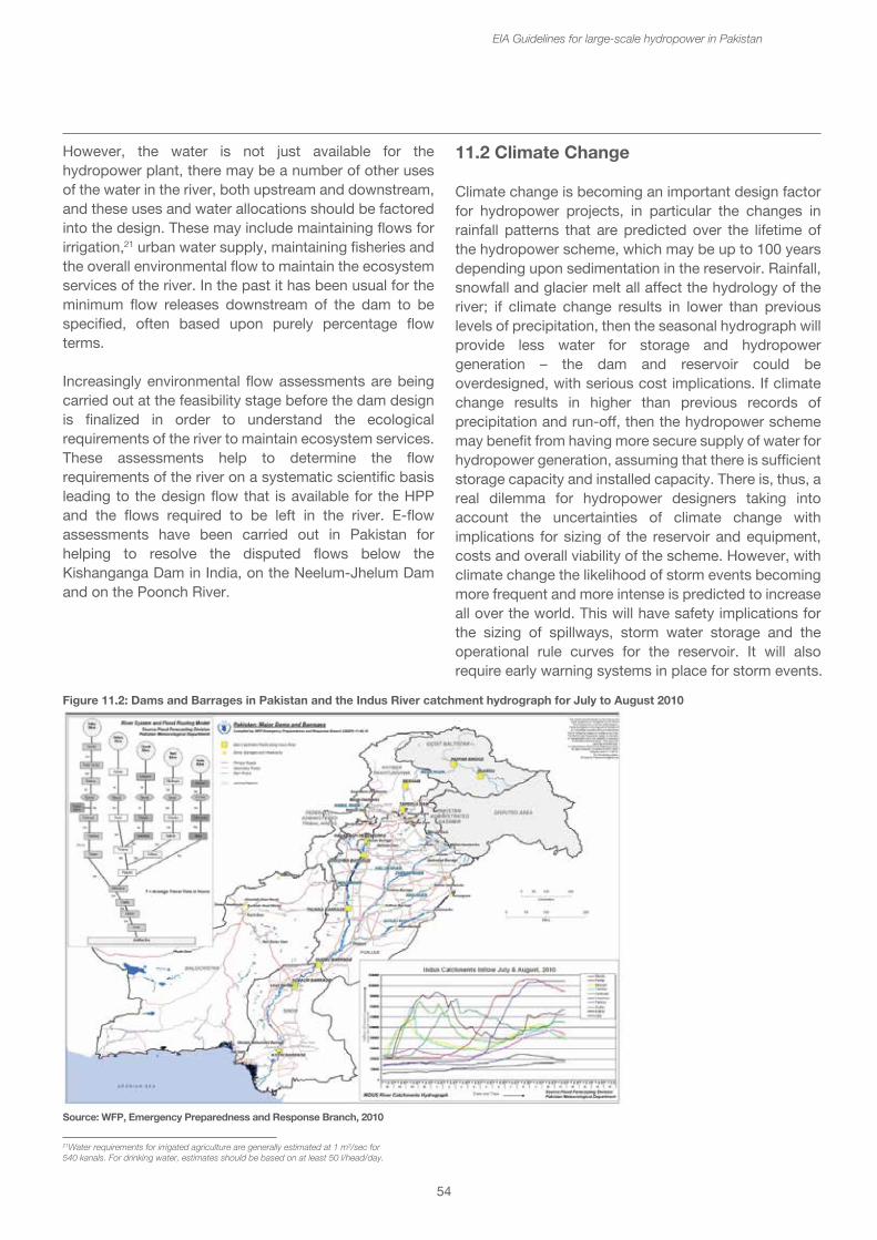
54
However, the water is not just available for the hydropower plant, there may be a number of other uses of the water in the river, both upstream and downstream, and these uses and water allocations should be factored into the design. These may include maintaining flows for irrigation,21 urban water supply, maintaining fisheries and the overall environmental flow to maintain the ecosystem services of the river. In the past it has been usual for the minimum flow releases downstream of the dam to be specified, often based upon purely percentage flow terms.
Increasingly environmental flow assessments are being carried out at the feasibility stage before the dam design is finalized in order to understand the ecological requirements of the river to maintain ecosystem services. These assessments help to determine the flow requirements of the river on a systematic scientific basis leading to the design flow that is available for the HPP and the flows required to be left in the river. E-flow assessments have been carried out in Pakistan for helping to resolve the disputed flows below the Kishanganga Dam in India, on the Neelum-Jhelum Dam and on the Poonch River.
EIA Guidelines for large-scale hydropower in Pakistan
11.2 Climate Change
Climate change is becoming an important design factor for hydropower projects, in particular the changes in rainfall patterns that are predicted over the lifetime of the hydropower scheme, which may be up to 100 years depending upon sedimentation in the reservoir. Rainfall, snowfall and glacier melt all affect the hydrology of the river; if climate change results in lower than previous levels of precipitation, then the seasonal hydrograph will provide less water for storage and hydropower generation – the dam and reservoir could be overdesigned, with serious cost implications. If climate change results in higher than previous records of precipitation and run-off, then the hydropower scheme may benefit from having more secure supply of water for hydropower generation, assuming that there is sufficient storage capacity and installed capacity. There is, thus, a real dilemma for hydropower designers taking into account the uncertainties of climate change with implications for sizing of the reservoir and equipment, costs and overall viability of the scheme. However, with climate change the likelihood of storm events becoming more frequent and more intense is predicted to increase all over the world. This will have safety implications for the sizing of spillways, storm water storage and the operational rule curves for the reservoir. It will also require early warning systems in place for storm events.
Figure 11.2: Dams and Barrages in Pakistan and the Indus River catchment hydrograph for July to August 2010
Source: WFP, Emergency Preparedness and Response Branch, 2010
21Water requirements for irrigated agriculture are generally estimated at 1 m3/sec for 540 kanals. For drinking water, estimates should be based on at least 50 l/head/day.
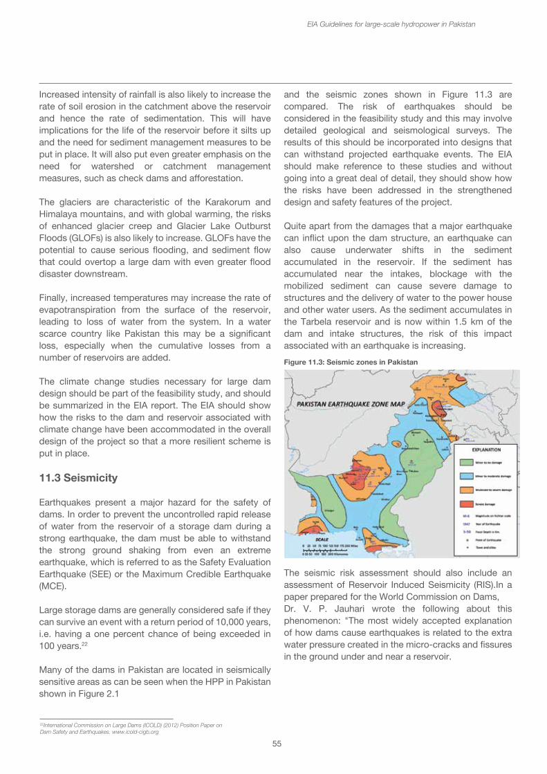
22International Commission on Large Dams (ICOLD) (2012) Position Paper onDam Safety and Earthquakes. www.icold-cigb.org
55
Increased intensity of rainfall is also likely to increase the rate of soil erosion in the catchment above the reservoir and hence the rate of sedimentation. This will have implications for the life of the reservoir before it silts up and the need for sediment management measures to be put in place. It will also put even greater emphasis on the need for watershed or catchment management measures, such as check dams and afforestation.
The glaciers are characteristic of the Karakorum and Himalaya mountains, and with global warming, the risks of enhanced glacier creep and Glacier Lake Outburst Floods (GLOFs) is also likely to increase. GLOFs have the potential to cause serious flooding, and sediment flow that could overtop a large dam with even greater flood disaster downstream.
Finally, increased temperatures may increase the rate of evapotranspiration from the surface of the reservoir, leading to loss of water from the system. In a water scarce country like Pakistan this may be a significant loss, especially when the cumulative losses from a number of reservoirs are added.
The climate change studies necessary for large dam design should be part of the feasibility study, and should be summarized in the EIA report. The EIA should show how the risks to the dam and reservoir associated with climate change have been accommodated in the overall design of the project so that a more resilient scheme is put in place.
11.3 Seismicity
Earthquakes present a major hazard for the safety of dams. In order to prevent the uncontrolled rapid release of water from the reservoir of a storage dam during a strong earthquake, the dam must be able to withstand the strong ground shaking from even an extreme earthquake, which is referred to as the Safety Evaluation Earthquake (SEE) or the Maximum Credible Earthquake (MCE).
Large storage dams are generally considered safe if they can survive an event with a return period of 10,000 years, i.e. having a one percent chance of being exceeded in 100 years.22
Many of the dams in Pakistan are located in seismically sensitive areas as can be seen when the HPP in Pakistan shown in Figure 2.1
EIA Guidelines for large-scale hydropower in Pakistan
Figure 11.3: Seismic zones in Pakistan
and the seismic zones shown in Figure 11.3 are compared. The risk of earthquakes should be considered in the feasibility study and this may involve detailed geological and seismological surveys. The results of this should be incorporated into designs that can withstand projected earthquake events. The EIA should make reference to these studies and without going into a great deal of detail, they should show how the risks have been addressed in the strengthened design and safety features of the project.
Quite apart from the damages that a major earthquake can inflict upon the dam structure, an earthquake can also cause underwater shifts in the sediment accumulated in the reservoir. If the sediment has accumulated near the intakes, blockage with the mobilized sediment can cause severe damage to structures and the delivery of water to the power house and other water users. As the sediment accumulates in the Tarbela reservoir and is now within 1.5 km of the dam and intake structures, the risk of this impact associated with an earthquake is increasing.
The seismic risk assessment should also include an assessment of Reservoir Induced Seismicity (RIS).In a paper prepared for the World Commission on Dams,Dr. V. P. Jauhari wrote the following about this phenomenon: "The most widely accepted explanation of how dams cause earthquakes is related to the extra water pressure created in the micro-cracks and fissures in the ground under and near a reservoir.
23http://www.environment.gov.pk/eia_pdf/f_Crit_%20Areas.pdf 24A useful guide to incorporating biodiversity in EIAs is published by the Convention on Biological Diversity Voluntary Guidelines on biodiversity inclusive impact assessment. http://www.cbd.int/doc/publications/imp-bio-eia-and-sea.pdf
56
When the pressure of the water in the rocks increases, it acts to lubricate faults which are already under tectonic strain, but are prevented from slipping by the friction of the rock surfaces." Depth of the reservoir is the most important factor, but the volume of water also plays a significant role in triggering earthquakes. RIS can be immediately noticed during filling periods of reservoirs, immediately after the filling of a reservoir or after a certain time lag.
Many of the dams in Pakistan are located in geologically young landscapes with relatively unstablised slopes. Landslides are a regular feature. When unstable slopes are inundated by the reservoir and experience periodic exposure and wetting, the risk of landslides increases. A major landslide occurring along the shoreline of a reservoir can cause a “tidal wave” that may damage or even overtop a dam. The feasibility and dam safety studies should identify the areas of unstable slopes along the reservoir shorelines and assess the risks of such landslides. Preventative measures to cause controlled landslips may be needed. The EIA should also report on these risks and preventative measures.
11.4 Impacts on sensitive locations
The guidance on sensitive and critical areas in Pakistan23
considers that there are two groups of these areas:
• Ecosystems – which include protected areas such as national parks, game reserves and wildlife sanctuaries.
• Archaeological and cultural sites – including archaeological sites, monuments, buildings and cultural heritage, and World Heritage listed sites.
That guidance document provides a listing of all the designated sites in these two categories in Pakistan. It also notes that if during the course of the EIA, the affected area appears to contain an ecological or archaeological/cultural site that is not listed, the proponent or the consultant should discuss this with the relevant conservation authority. The full and updated list of sensitive and critical areas will be included in the EIA tracking website under development by the NIAP project (www.niap.pk).
Note that outside of these designated areas there may be locations that are sensitive from environmental or social perspectives, these are also discussed below.
EIA Guidelines for large-scale hydropower in Pakistan
During the scoping or detailed baseline surveys required for the EIA of project, certain affected locations or situations may be particularly sensitive to the impacts. The EIA report should identify these and make special provisions for protection or mitigation.
11.4.1 Protected Areas (national parks, game reserves, wildlife sanctuaries)
If a large hydropower project is proposed to be located in or near a protected area, additional precautions need to be taken and the EIA should show how the threats to the integrity of the protected area have been considered and mitigated. There are several significant impacts from large hydropower schemes that may affect protected areas. These are a) direct impacts from construction activities of schemes within protected areas, including access roads and transmission lines and b) inundation of part of the areas by the reservoir, c) fragmentation of the protected area, creating barriers for movement of animals and dividing it up into smaller, less ecologically intact parts, due both to access roads, transmission lines and the reservoir itself, and d) indirect impacts resulting from increased access to these areas enabling illegal logging and hunting. All of these impacts will lead to degradation of these natural resource assets and loss of biodiversity.24
If the all or part of the hydropower project is located within or nearby a protected area, then the EIA should include an assessment of the size and proportion of the disturbed area within the protected area, a description of the landscape, habitats, and flora and fauna at risk from the development, and the mitigation measures. Fragmentation of the protected area can be assessed by counting the number and sizes of distinct parts of the PA created by the project. The significance of the fragmentation should be assessed relevant to the habitats and species with large ranges that may be affected.
If the area of the PA affected is substantial and endangered species are considered to be at risk, the hydropower scheme may not be appropriate. Design alternatives in terms of location, height of the dam and size of reservoir, other routes for access and transmission lines need to be considered seriously and compared before any final decisions are taken, in order to minimize the impacts.
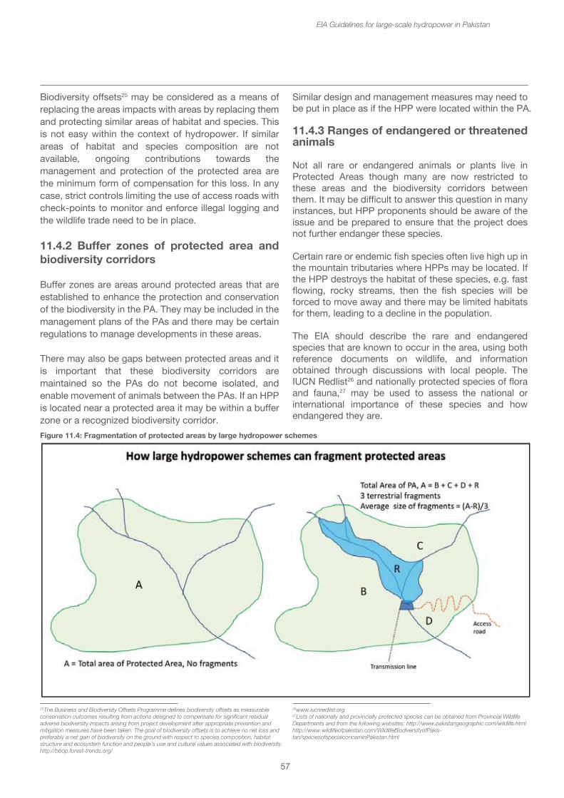
25The Business and Biodiversity Offsets Programme defines biodiversity offsets as measurable conservation outcomes resulting from actions designed to compensate for significant residual adverse biodiversity impacts arising from project development after appropriate prevention and mitigation measures have been taken. The goal of biodiversity offsets is to achieve no net loss and preferably a net gain of biodiversity on the ground with respect to species composition, habitat structure and ecosystem function and people’s use and cultural values associated with biodiversity. http://bbop.forest-trends.org/
26www.iucnredlist.org 27Lists of nationally and provincially protected species can be obtained from Provincial Wildlife Departments and from the following websites: http://www.pakistangeographic.com/wildlife.html http://www.wildlifeofpakistan.com/WildlifeBiodiversityofPakis-tan/speciesofspecialconcerninPakistan.html
57
Biodiversity offsets25 may be considered as a means of replacing the areas impacts with areas by replacing them and protecting similar areas of habitat and species. This is not easy within the context of hydropower. If similar areas of habitat and species composition are not available, ongoing contributions towards the management and protection of the protected area are the minimum form of compensation for this loss. In any case, strict controls limiting the use of access roads with check-points to monitor and enforce illegal logging and the wildlife trade need to be in place.
11.4.2 Buffer zones of protected area and biodiversity corridors
Buffer zones are areas around protected areas that are established to enhance the protection and conservation of the biodiversity in the PA. They may be included in the management plans of the PAs and there may be certain regulations to manage developments in these areas.
There may also be gaps between protected areas and it is important that these biodiversity corridors are maintained so the PAs do not become isolated, and enable movement of animals between the PAs. If an HPP is located near a protected area it may be within a buffer zone or a recognized biodiversity corridor.
EIA Guidelines for large-scale hydropower in Pakistan
Similar design and management measures may need to be put in place as if the HPP were located within the PA.
11.4.3 Ranges of endangered or threatened animals
Not all rare or endangered animals or plants live in Protected Areas though many are now restricted to these areas and the biodiversity corridors between them. It may be difficult to answer this question in many instances, but HPP proponents should be aware of the issue and be prepared to ensure that the project does not further endanger these species.
Certain rare or endemic fish species often live high up in the mountain tributaries where HPPs may be located. If the HPP destroys the habitat of these species, e.g. fast flowing, rocky streams, then the fish species will be forced to move away and there may be limited habitats for them, leading to a decline in the population.
The EIA should describe the rare and endangered species that are known to occur in the area, using both reference documents on wildlife, and information obtained through discussions with local people. The IUCN Redlist26 and nationally protected species of flora and fauna,27 may be used to assess the national or international importance of these species and how endangered they are.
Figure 11.4: Fragmentation of protected areas by large hydropower schemes
58
Usually EIAs provide lists of all the flora and fauna known to have occurred in the area in the past. Whilst these lists are indicative of the biodiversity in the region, the assessment would be more effective if the baseline surveys confirm the presence of the key species and if the risks to these species and their habitats are described. Consider the habitats and ranges used by these species and describe whether the area affected contains such habitats, i.e. the likelihood that the species can be found there.
Note that many such lists record historic occurrence, and the surveys may find that some species have since disappeared. The EIA can then highlight the fact that this disappearance has not been not caused by the hydropower project. Often all such changes are automatically attributed to the hydropower project, when the loss of the species from the locality had resulted from other pressures. EIAs also tend to focus on the obvious flora and fauna, e.g. birds and mammals, but missing out on taxonomic groups such as amphibians and reptiles, and as well as fish and macro-invertebrates. Pollinators such as bats and insects, e.g. bees should also be included. The baseline surveys should not be restricted to the areas of immediate impact, but also include the larger catchment area upon which the dam and its reservoir depend.
If rare and endangered species are present and their habitats are considered to be at risk, special measures may be required for their added protection.
Box 14: River Poonch Mahseer National Park, Poonch, Kotli, Mirpur (Azad Jammu and Kashmir)
AJK Fisheries and Wildlife department declared the entire length of Poonch River in Azad Jammu and Kashmir as the first ever aquatic-protected area for a globally threatened species of fish in 2011. The Poonch River, its tributaries and their beds have been designated as ‘River Poonch Mahseer National Park’. The protected area extends to the 62 kilometer length of Poonch River - from Degwar Madarpur where it enters the AJK territory from occupied Kashmir to Dadyal, where it drains into Mangla dam.
Species of ImportanceGradual decline in the population of Golden Mahseer threatened species was a matter of grave concern for declaration of river as national park. Golden Mahseer, scientifically known as “Tor Putitora”, is the largest fresh water fish found in many of the rivers originating from Himalayas.
EIA Guidelines for large-scale hydropower in Pakistan
The Mahseer fish inhabits the southern watersheds of the Himalayas and prefers to live in lakes, dams or manmade impoundments but migrates upwards to the tributaries to locate the shallow, gravel stream beds where it breeds each year.
Threats• Intensive over fishing, use of illegal means for fishing• Extraction of gravel and sand from riverbed – destruction of habitat • Pollution in the river • Lack of interest, disorganized community • Lack of scientific knowledge
11.4.4 Unique or aesthetically valuable landscapes or water forms
Many rivers contain important features that are valuable parts of the landscape. Some may also be sites for tourism or recreation, e.g. beauty or picnic spots. If the HPP would be located near such features, then these should be described and their importance indicated. If the HPP is located downstream of such a feature, the reservoir may inundate the feature, i.e. the waterfall or rapid will be lost. If the feature is located between the dam and the power house, then its appearance or function may be damaged by shortage of water, especially during the low flow season. If the feature lies below the power house, then the changes in flow (daily or overall increases) may affect the appearance or function. These impacts should be described.
Complete loss of the feature may be the result, in which case this should be noted as unavoidable. Complete loss may not be mitigated. If the feature is likely to be changed due to changes in flow regimes, then this too should be noted. It is possible that flow regimes could be modified to minimize the impact. Describe the flow requirements to minimize the impact in order to maintain the feature.
11.4.5 Wetlands
There are two sorts of wetland to be concerned about a) the in-channel wetlands and b) the floodplain wetlands. The in-channel wetlands are those areas of river that become seasonally dry as river levels drop and have rocks and sandbars exposed. The vegetation that grows there consists of reeds, grasses and shrubs that can withstand being flooded as the water levels rise in the wet season.
These are very productive areas of the river, providing
59
both food and refuge for fish and other aquatic animals. The floodplain wetlands are those that are covered at times of high flow in the river, when the floodwater overtops the banks. Typically these occur at the bottom end of rivers, near the mouth or confluence with larger rivers.
Both types of wetland are sensitive to hydrological changes, especially if the flow is regulated. In-channel wetlands may reduce in size if the dry season flows increase, i.e. they are inundated for longer and the vegetation does not have an adequate period for growing. Floodplain wetlands may be affected if the wet season flows are reduced, so that peak flows are smaller and do not reach the floodplains except in years of higher flows.
If such wetlands are present in the river on which the HPP is located, then further investigation should show where these wetlands are in relation to the hydropower structures and how they will respond to changes in flow induced by the project. The wetlands occurring between the dam and the power house will be the ones most affected. In the case of diversion between rivers, the wetlands in the intake river will be most affected by flow reductions.
Mitigation measures include ensuring that adequate flows reach the wetlands below the dam at critical times of year, e.g. during the low flow season. However, in an inter-basin diversion scheme, the impacts from reduction in flows in the intake river below the dam cannot be mitigated.
11.4.6 Important stretches of the river for fish breeding and spawning
Many fish migrate up tributaries of larger rivers in order to spawn, and then make their way back to the larger river for other parts of the life cycle. Some rivers on which HPP are proposed may be important for fish breeding and spawning, particularly if they have features such as deep pools, rapids and riffles, and in-channel wetland areas (see below). Other rivers may be more difficult for the fish to move up, especially if they have high waterfalls or very steep rapids, that the fish cannot climb. Local information from communities using these rivers may be an essential complement to scientific studies.
If the river is recognized as important for fish breeding and spawning, and the spawning grounds lie above the weir or dam, then some sort of fish passage would be needed to allow the fish to pass around the barrier.
EIA Guidelines for large-scale hydropower in Pakistan
If the spawning grounds lie below the dam, but above the power house, then it will be necessary to find out the times of year when spawning occurs, and make sure that there is sufficient flow downstream of the dam for that to continue. Most, but not all, migration and spawning occurs in the early monsoon. If the spawning grounds lie below the power house, then the impact will be lower, although migration could still be affected if flows are changed significantly.
Fish passage is generally possible for low dams and weirs up to about 10 m in height, but has proved less successful for higher dams and for fish other than salmonids, however the understanding of fish passage requirements of other species may lead to improved designs. If breeding sites or tributaries where the fish breed are located below the dam, then adequate flow regimes should be maintained at critical times of year when fish are spawning.
Box 15: Spawning of Mahseer, Tor tor
Mahseer are an important migratory, cold water fish frequenting many Pakistani rivers. They are found in rivers and streams fed by perennial snow melt water. They migrate quite long distances to feed and spawn, entering side streams or torrential stretches of rivers and return to the main river when the water begins to subside. Monsoon floods and physico-chemical factors induce Mahseer to ascend to their spawning grounds. It has been observed that they may spawn several times in a season. They require a gravel substratum to lay their eggs in sheltered rock pools where they can be safely covered to stop them being washed away by strong current. Water temperature is an important determinant and they appear to avoid very cold water, which may explain why they congregate in hundreds in lower reaches of the Indus tributaries, e.g. Jhelum, Chenab during the winter months of December and January.
Successful fish ladders for Mahseer have been reported from the Ganga River at Hardwar, but other fishways have proved to be ineffective. A thorough study on the migration behavior of Mahseer is needed in order to design species or genus specific fishways. As it is, existing fish ladders tend to become fish traps rather than facilitating Mahseer migration. With increasing numbers of rivers and streams being dammed and converted to reservoirs, many of the spawning habitats throughout the Indian sub-continent are being lost or become inaccessible.
Abstracted from Desai, V.R. (2003) Synopsis of biological data for the Tor Mahseer, Tor tor (Hamilton, 1822) FAO Fisheries Synopsis No 158, Rome FAO.
60
11.4.7 Unregulated river or undammed river
A river that is already regulated by either hydropower or irrigation scheme is less sensitive to hydrological impacts than one which has no such dams or schemes. In general, it is better to choose sites on rivers or tributaries that are already impacted by hydropower, than those where the river is running freely.
If the proposed HPP is sited on an unregulated river, then additional investigation may be required to describe the degree of regulation that will result from the scheme and the changes in the flow regimes expected. The EIA should describe the importance and ecosystem value of that unregulated river to show how this will be changed if it is dammed. If the undammed river is particularly sensitive or valuable, it may be better to avoid this location.
11.4.8 Existing or proposed irrigation schemes near or associated with the HPP
Many hydropower projects in Pakistan are associated with irrigation schemes or have multiple uses that include irrigation. In this case, the irrigation requirements will have been factored into the design of the hydropower project and the expected changes in the hydrology and allocation of waters will have been taken into account.
However, when an HPP is proposed on a river which already supplies irrigation water, the changes in flow resulting from the hydropower project may adversely affect this supply. If the water abstraction point for the irrigation scheme is located between the dam and the power house, i.e. where the flows in the river are significantly lower, or taken from downstream of a dam in an inter-basin diversion project, then there may not be sufficient water left for the irrigation scheme.
Conversely, the river downstream of the power house may have a more seasonally balanced flow and have higher flows in the drier winter months of Pakistan, and be able to provide more water for irrigation. This would be a benefit. Similarly, rivers receiving waters from inter-basin diversions would have higher flows downstream of the power house.
The quality of the water available for irrigation downstream of the power house may also be an issue. Poor quality water (anoxic) may be released from the reservoir especially after inundation, which should not be used for agriculture, and this may limit the availability of water for irrigation schemes. Similarly, water carrying
EIA Guidelines for large-scale hydropower in Pakistan
very high sediment loads, e.g. after sediment flushing, may block irrigation channels and cover crops with sediment.
The EIA report should describe any existing or proposed irrigation schemes associated with the HPP and show how water allocation for both hydropower and irrigation has been factored into the design. If there already irrigation schemes on the river that may be affected by the proposed hydropower plant, the cropping patterns and annual and seasonal water requirements should be described. The impact assessment should estimate the changes in flow in the river and the availability of water for the affected irrigation scheme. It should also ensure that after both, the dam and the irrigation scheme there would be sufficient environmental flow to maintain the ecosystem functions of the river.
Mitigation measures should ensure that the flow changes caused by the HPP, will not affect the water requirements for existing (or planned) irrigation schemes on the affected rivers.
11.4.9 Unstable land areas where there has been soil erosion and landslips
Construction activities in areas where the land is known to be unstable will add to the risk of soil erosion and landslides. Temporary access roads where inadequate attention is paid to drainage and tunneling can add to the instability of such slopes. As reservoirs fill and are drawn down, the wetted areas of the shoreline around the reservoir may slump and even cause landslips into the reservoir. If the landslips in a reservoir are substantial they can cause potentially dangerous “tidal” waves.
The feasibility study should have carried out an assessment of the slope stability around the construction site and in the reservoir area, and this information should be incorporated into the EIA report. If the risk of soil erosion and landslips is high, the additional measures needed a) to protect weak slopes, b) to minimize the risks to dam structures and c) to manage soil erosion during construction. If especially unstable slopes are found around the shoreline and in the drawdown zone of the reservoir, then it may be necessary to cause controlled landslips before the reservoir is filled.
61
11.4.10 Area used by ethnic minority groups
About 96% of Pakistan’s population falls into the major ethnic groups of Punjabi, Sindhi, Pathan, Saraiki, Muhajir, and Balochi. However, the remaining 4% are other ethnic minorities include the Hazara, Balti, Chitrali, Pamiri and Kalash peoples. The home areas of these minorities tend to be in the northern mountainous areas, i.e. in the same locations as many of the proposed hydropower plants. These ethnic minority groups have different social and cultural identity and usually have a collective attachment to geographically distinct areas. HPP construction and operation can change the areas used by these groups so they are not either accessible to them, or the natural resources are reduced.
The IFC Performance Standards No. 728 refers to Indigenous Peoples and uses the term in the generic sense to refer to distinct groups that have the following characteristics:
• Self-identification as members of a distinct indigenous cultural group, and recognition of this identity by others;
• Collective attachment to geographically distinct habitats or ancestral territories in the project area and the natural resources;
• Customary cultural, economic, social and political institutions that separate them from those of mainstream society;
• A distinct language or dialect, often different from the official language of the country.
If the project area contains or is used by groups that may be considered to fall within this definition then there are special requirements that the project and the EIA should follow including a) avoidance of adverse impacts, b) Participation and consent, c) Mitigation and Development benefits. The term “Free, Prior and Informed Consent” (FPIC) is used to describe good faith negotiation between the project proponent and the affected communities of indigenous peoples. The mutually accepted process between the proponent and the affected communities should be documented and provide evidence of agreement between the parties as the outcome of the negotiations. A special Ethnic minority action plan may be prepared showing how the impacts upon these ethnic groups and their resources will be mitigated and managed.
EIA Guidelines for large-scale hydropower in Pakistan
11.4.11 Archaeological and cultural sites
This category of sensitive sites includes archaeological sites, monuments, buildings and cultural heritage, and World Heritage listed sites. These sites may be important for cultural or historic heritage reasons, or because they are sacred or religious sites with ancient mosques, shrines, cemeteries or other sacred sites, or because they contain archaeological remains. Some of these places may have importance for tourism or education and research. Hydropower construction activities and inundation by the reservoir can damage or destroy these sites.
If the project area or the reservoir contains designated sites, then management measures will be needed to show how the cultural or historic assets will be protected during construction and operation. These should be described in an archaeological and cultural heritage management plan. It may not be possible to define whether the area is archaeologically sensitive, but sometimes archaeological remains turn up when the earth is moved during construction. In such instances, a “chance find process” should be in place, so that if such remains are uncovered, the Federal or Provincial Department of Archaeology should be informed, and construction work around the find temporarily halted until the find has been investigated. Contracted construction companies and workers should be informed and obligated to follow this “chance find process”.
12. Key environmental impacts during construction Many of the construction impacts are similar to all large infrastructure projects and require similar provisions for managing and mitigating the environmental impacts. The construction impacts that relate to large hydropower and the impact zones are discussed more specifically with reference to the following matrix of hydropower construction activities which indicates the type and potential scale of impacts in the four main impact zones. Note that these are potential impacts and risks, which would be managed and mitigated. The significance of these impacts is then explained, with the information required in the assessment process and the possible mitigation or management measures identified in the following narrative sections.
28IFC Performance Standards on Environmental and Social Sustainability, www.ifc.org/sustainability
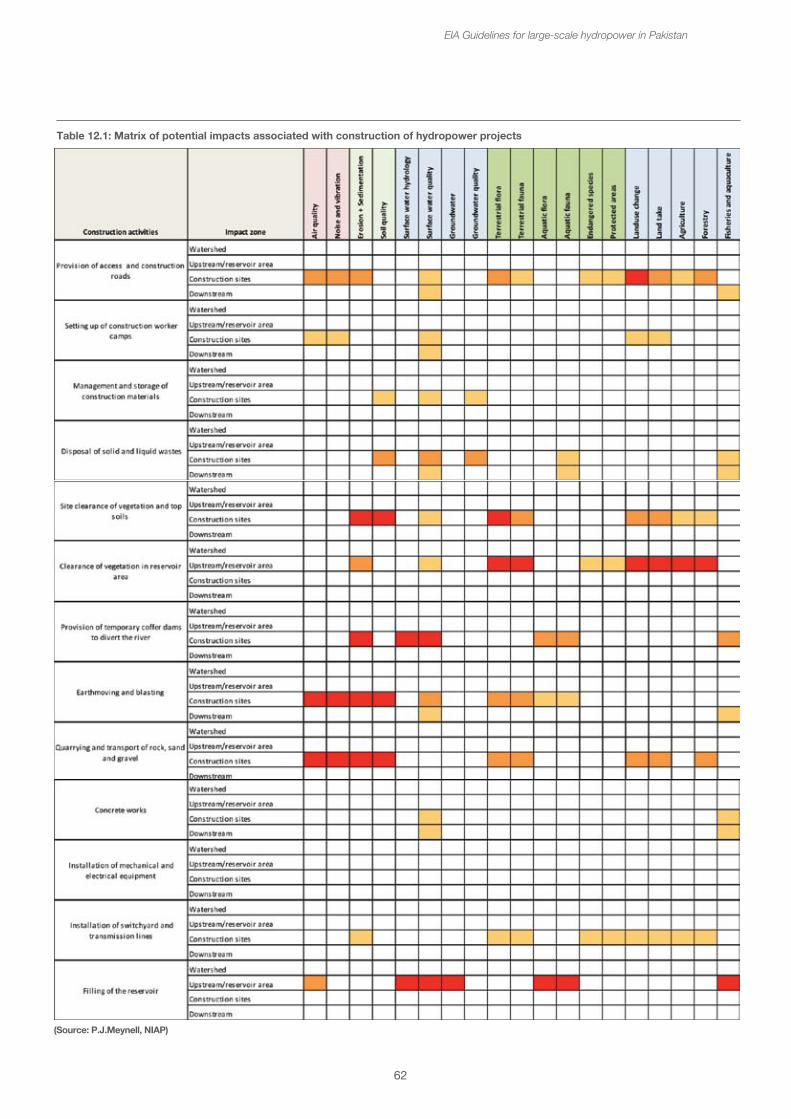
62
Table 12.1: Matrix of potential impacts associated with construction of hydropower projects
EIA Guidelines for large-scale hydropower in Pakistan
(Source: P.J.Meynell, NIAP)
63
12.1 Physical impacts
12.1.1 Air quality
The main air quality issues will be concerned with dust and particulates in the air caused by the construction and earth moving activities, and along the access haul roads where the transport of quarried materials are brought to the site. The EIA report should consider the proximity of communities and houses to the construction site and haul roads and the prevalent wind direction. Management of dust may not be easy and may require regular dust suppression e.g. spraying of water on the access roads. Along access roads, speed restrictions through communities will help to reduce dust from the road transport to the construction site.
Other air quality issues during construction arise from the exhausts of vehicles, generators and other machinery. This should be managed through regular maintenance of all equipment to minimize emissions.
12.1.2 Noise and vibration
All construction sites create noise levels above the previous ambient levels. This cannot be avoided. Vibrations from the compactors are a necessary part of the construction process. The use of explosives for blasting rock in the dam site preparation and in quarries will create excessive temporary noise and vibration and disturbance for nearby communities. Quarries may be located at some distance from the dam site. The EIA report should identify the communities nearby and the extent to which they may be disturbed by blasting. Livestock and wildlife may also be disturbed by blasting. The management of blasting activities will need to be discussed with local communities with agreement on fixed blasting times and the warnings to be provided.
12.1.3 Erosion and Sedimentation
Earthmoving activities and road construction can exacerbate soil erosion, especially in areas already prone to erosion. Whilst this is to be expected at the construction site and would be taken care of during the rehabilitation of the site after construction activities are completed, accidental erosion may also occur along access roads if there is inadequate attention to design and drainage. This often happens when temporary, and hence lower cost and quality, roads are built.
EIA Guidelines for large-scale hydropower in Pakistan
One of the major impacts from soil erosion occurs when the eroded soils reach the river and increase the sediments, suspended solids and turbidity in the river. Excessive sediments in the river can extend for many kilometers downstream, and tend to cover aquatic vegetation and habitats, e.g. gravel beds that are important for the river health and fisheries downstream. Highly turbid water can also drive away fish to cleaner parts of the river, and may cause mortality as the sediments cover aquatic invertebrates and coat the gills of the fish.
The EIA should identify areas that are particularly at risk of soil erosion, where attention to design and good drainage of roads is required. Whilst the escape of some sediments into the river is unavoidable, earthmoving and other construction best practice should be used to minimize the risk of sediments reaching the river. Contractors should be obligated to follow such practices.
12.1.4 Soil quality
There are a number of issues related to soil quality during construction. Some of these relate to specific locations where the construction materials are stored, near vehicle maintenance areas, or fuel and oil storage where accidental spillage can contaminate the soil, which will then have to be cleared up later after construction has been finished. Similarly the disposal of solid wastes is an issue for all large construction sites, and potentially toxic materials should be removed to special waste disposal sites to prevent contamination of both ground water and soils.
Earthmoving and quarrying activities can cause significant damage to soil quality. Top soils should be removed with care and stored appropriately for later use during the rehabilitation of the construction site. This is important in locations where the top soil is thin and relatively poor. The EIA should note the soil types and quality in the location of the construction site, and any special measures that are needed to protect these soils.
The disposal of spoil material from quarrying and earthmoving may also be a significant issue. Spoil is waste material that cannot be used in the construction because it is either not of the required quality or specification, or because it is surplus to requirements.
64
The spoil can degrade the area on which it is disposed, and if large quantities are involved the impact on the land may be severe. The EIA should specify the quantities of excavated spoil to be disposed of and identify the area of land required for its disposal. Potential sites for disposal may also be identified so that the impact can be assessed, but the places where least impact would occur include use in roads building, backfilling in quarries where extraction has been finished, or disposal in the reservoir area that will be inundated.
12.2 Hydrological impacts
12.2.1 Surface water hydrology
There are two periods when the surface water hydrology will be significantly changed during the construction of large hydropower. The first is, perhaps, more of a local and temporary nature resulting from the diversion of the river by coffer dams. Coffer dams allow parts of the river bed to be successively dewatered so that construction activities can take place. They are temporary in nature and are removed after the dam has been constructed. The river may be diverted through side tunnels around the dam which are then blocked off when at river closure – i.e. when the reservoir starts to fill. The diversion of water by coffer dams and tunnels does not cause major change in the overall river hydrology.
The second occasion when the surface water hydrology is changed is during the filling of the reservoir. This usually takes place during the period of high flows, so that a proportion of the water is retained within the reservoir, allowing a reduced flow to pass on downstream. In some very large storage reservoirs, the filling of the reservoir may take more than one year. In some instances the reservoir will be filled progressively as the dam is raised. The main impacts that will occur are changes in the flow downstream. As the dam fills, less water is available to flow downstream, so that the river flows downstream of the dam will be will be lower than normal at that time of year.
The EIA should report at least on the historic monthly average flows downstream of the dam site. It should then describe the process of reservoir filling, the length of time and season and expected flow reductions in the monthly flows. In terms of management, it is suggested that in order to minimize the disruption to the downstream river flow, the quantity of water allowed to flow downstream should never be less than the minimum recorded flow at that time of year.
EIA Guidelines for large-scale hydropower in Pakistan
12.2.2 Surface water quality
The main impacts upon surface water quality during the construction period arise from increased sediment load, suspended solids and turbidity caused by the site preparation and earth moving. Waste water from the construction worker camps and construction site offices may also cause pollution unless adequately treated.
Accidental spillage of construction chemicals, fuel and oil may also cause water pollution. The accidental spillage of freshly mixed concrete into the river can cause serious water pollution and depletion of dissolved oxygen. Washing of concrete mixers directly in the river should be avoided.
During the clearance of vegetation in the reservoir area and during the filling of the reservoir, the process of breakdown of dead vegetation is likely to cause an increase in BOD and COD29 and depletion of dissolved oxygen. This will reduce water quality, both in the reservoir and in the flow of water downstream.
The EIA should provide details of existing water quality in the river upstream of the dam, at the dam site and at a number of locations downstream. Ideally these should be taken at different times of year before construction starts to establish a baseline.
Specific potential sources of water pollution, such as waste water from construction worker camps, should be identified and waste water treatment facilities provided. Risks of accidental spillage from fuel and oil stores and other liquid construction materials should be managed appropriately, e.g. though construction of bunds around the stores. An emergency action plan and equipment should be in place for dealing with accidental spillages. Best practice procedures for minimizing the increased sediment mobilization from earth moving activities should be established. A water quality monitoring programme must be implemented throughout the construction period.
12.2.3 Groundwater and Groundwater quality
There are unlikely to be any major impacts or changes in ground water movements or levels during the construction period.
29BOD = Biological Oxygen Demand, COD = Chemical Oxygen Demand
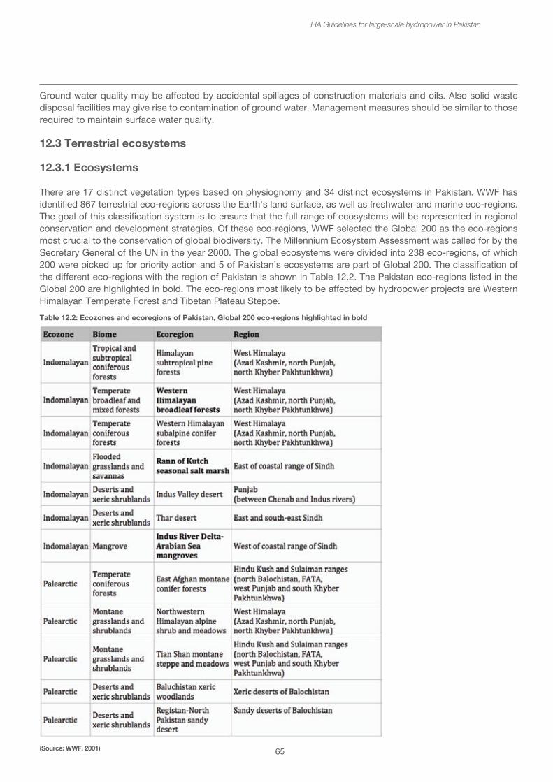
65
Ground water quality may be affected by accidental spillages of construction materials and oils. Also solid waste disposal facilities may give rise to contamination of ground water. Management measures should be similar to those required to maintain surface water quality. 12.3 Terrestrial ecosystems
12.3.1 Ecosystems
There are 17 distinct vegetation types based on physiognomy and 34 distinct ecosystems in Pakistan. WWF has identified 867 terrestrial eco-regions across the Earth's land surface, as well as freshwater and marine eco-regions. The goal of this classification system is to ensure that the full range of ecosystems will be represented in regional conservation and development strategies. Of these eco-regions, WWF selected the Global 200 as the eco-regions most crucial to the conservation of global biodiversity. The Millennium Ecosystem Assessment was called for by the Secretary General of the UN in the year 2000. The global ecosystems were divided into 238 eco-regions, of which 200 were picked up for priority action and 5 of Pakistan’s ecosystems are part of Global 200. The classification of the different eco-regions with the region of Pakistan is shown in Table 12.2. The Pakistan eco-regions listed in the Global 200 are highlighted in bold. The eco-regions most likely to be affected by hydropower projects are Western Himalayan Temperate Forest and Tibetan Plateau Steppe.
EIA Guidelines for large-scale hydropower in Pakistan
Table 12.2: Ecozones and ecoregions of Pakistan, Global 200 eco-regions highlighted in bold
(Source: WWF, 2001)
66
12.3.2 Terrestrial flora and fauna
During construction the main impacts upon terrestrial fauna and flora will be the removal of any vegetation from the construction site(s) and dispersal of any fauna. If biomass clearance is required in the reservoir, then trees and other vegetation will be cut down and removed (if valuable) or burnt. Quarrying activities with associated blasting may disturb wildlife and drive them away.
During construction and soil movement the conditions are often created for the spread of invasive alien species. These species are often brought in with construction equipment. The baseline survey should indicate the presence of invasive species in the area, and identify possible species likely to invade, e.g. from elsewhere in the country. Routine surveys for invasive species should be built into the monitoring programme at least during the construction phase.
The EIA should describe the total area disturbed by the construction site(s), access roads, quarries etc. The vegetation cover and types (e.g. forest, woodland, shrubland, grassland etc.) should be described, together with any significant species found or likely to be found in the location of the construction site. This may be related to the surrounding landscape assessing the proportion of the landcover and types found within the nearby area (e.g. within a 5 – 10 km radius of the dam site) that will be lost. The typical fauna associated with these types of habitat should be identified.
The loss of this vegetation cover is unavoidable, and if the loss is significant it should be taken with the area inundated by the reservoir in some sort of compensation or biodiversity offset.
12.3.3 Endangered species and critical habitats
The activities at the construction site and clearance and filling of the proposed reservoir area may directly endangered species. If the population in the area is relatively small and the habitat requirements quite restricted, the overall population may threatened. If, for example, the elevation range of a species is low down the hillside, and the filling of the reservoir would force the population up to a higher elevation, they might not survive. This applies particularly to plant species that may have a very restricted range, especially those that are adapted to growing along the riverbanks.
EIA Guidelines for large-scale hydropower in Pakistan
Riverine trees are most likely to be lost, and may not easily survive along the banks of the reservoir. Islands in the reservoir may also become refuges for certain endangered species, and although there may be initial survival, the overall biodiversity of the island will tend to become more restricted over time.
The construction activities are likely to involve considerable disturbance, even at some distance from the sites, and this will tend to drive many of the more mobile species away. New access roads and transmission lines will provide access into more remote areas not previously disturbed, and this may add hunting pressure upon endangered species. During construction, certain activities, e.g. blasting or diversion of the river may be particularly damaging for populations of particular threatened or migratory species. It may be appropriate to modify the timing of such activities to cause the least disturbance, especially during breeding seasons or annual migrations.
The EIA should document the endangered species likely to be found in the different impact zones, and if possible provide an assessment of their populations in these areas. There should be a risk assessment of the selected species, which would include their habitat preferences and distribution, both nationally and within the area around the constructions site and proposed reservoir. This risk assessment should consider the impact of the hydropower project and whether the species considered is likely to be lost from the area and whether it might cause a change in the overall endangered status of the species (i.e. the IUCN Redlist status).
The IFC Performance Standard 6 on Biodiversity Conservation and Sustainable Management of Living Natural Resources is probably the most comprehensive of the international environmental safeguards covering this topic. It addresses how developers can sustainably manage and mitigate impacts on biodiversity and ecosystem services throughout the project’s lifecycle, aiming to protect and conserve biodiversity, maintaining the benefits of ecosystem services and promoting the sustainable management of living natural resources through the adoption of practices that integrate conservation needs and development priorities. It divides habitats into modified, natural and critical.
67
Critical habitats are those with high biodiversity value including habitats of significant importance to i) Critically Endangered or Endangered species, ii) to endemic or restricted range species, iii) habitats supporting globally significant concentrations of migratory or congregatory species, iv) highly threatened and unique ecosystems and v) areas associated with key evolutionary processes.
The IFC would not support a project that could not demonstrate i) that no other viable alternatives within the region exist for the development of the project on modified or natural habitats that are not critical; ii) that the project does not lead to measureable adverse impacts on these biodiversity values for which the critical habitat was designated; iii) that it does not lead to a net reduction in global and national regional populations of any Critically Endangered or Endangered species over a reasonable period of time; iv) that a robust, appropriately designed and long-term biodiversity monitoring and evaluation programme is integrated into the projects management plan.
If endangered species or critical habitats are identified within the impact zones, the EIA and EMP should therefore demonstrate these main points. The mitigation strategy should be described in a Biodiversity Action Plan and designed to achieve net gains of those biodiversity values for which the critical habitats were designated. Biodiversity offsets may be proposed as part of this mitigation strategy.
Box 16: Biodiversity offsets
Biodiversity offsets are measureable conservation outcomes resulting from actions designed to compensate for significant residual adverse biodiversity impacts arising from project development after the prevention and mitigation measures have been taken. The goal of biodiversity offsets is to achieve no net loss of biodiversity and a preferable net gain on the ground (or in the water) with respect to species composition, habitat structure, ecosystem function and peoples use and cultural values associated with biodiversity.
These principles establish a framework for designing and implementing biodiversity offsets and verifying their success. Biodiversity offsets should be designed to comply with all relevant national and international laws and planned and implemented in accordance with the Convention on Biological Diversity and its ecosystem approach.
EIA Guidelines for large-scale hydropower in Pakistan
There is no mandatory biodiversity offsetting established in Pakistan. Voluntary offsetting may be used to recognize and compensate for the impacts of a hydropower scheme. Offsets can be managed in two ways: i) directly through the hydropower developer themselves, or ii) through a third party, with the company making compensation payments or buying biodiversity credits (c.f. carbon credits). Similarly there are two approaches - one focused on conservation or preservation of the biodiversity that is in the area, and the other focused on restoration and biodiversity enhancement of degraded areas.
Biodiversity offsetting is most effective if a functional relationship can be established between the biodiversity lost and the offset. A strong functional relationship would consider in-kind offsets, or like-for-like, whereby the stretch of river ecosystem lost would be offset by protection measures on a similar stretch of river in a nearby catchment. A loose functional relationship would be an out-of-kind offset, e.g. the impacts on a protected area with one set of habitats would be offset by rehabilitation of degraded areas with a different set of habitats.
Similarly there may be strong spatial relationship where the offset is on-site or closely adjacent to the hydropower plant, e.g. within the watershed. A looser spatial relationship may provide off-site protection or management support for a protected area in a different catchment.
The critical first step to developing a biodiversity offset plan is to know what is being lost and cannot be remediated, i.e. what is being offset. This may be known from the EIA, but may require more detailed studies. There are evolving complex methods for valuing and comparing the biodiversity lost with what can be used for offsetting, using quality area as the basic unit of assessment, i.e. area lost x the biodiversity quality. An on-site, like-for-like offset may require only protection of 1x or 1.5x the area lost, whilst looser functional and spatial relationships may require larger areas to be protected.
The Biodiversity Offset Design Handbook prepared by the Business and Biodiversity Offsets Programme (BBOP), provides guidance for the design of biodiversity offsets. http://bbop.forest-trends.org and https://www.cbd.int/financial/offsets/

68
12.3.4 Protected areas
If the site or access roads are located within or near a protected area, there may be more significant impacts. See above section 11.4.1.
12.3.5 Land take and Landuse change
The land take is one of the most significant impacts of a large hydropower scheme. The construction site itself may be several hundreds of hectares, and the reservoir may cover many square kilometers. Hydropower plants are usually located in remote rural locations and the main landuse will be converted from agriculture, or forestry or in some cases protected areas. There may be some buildings and infrastructure that will be inundated as well. In the dam and power house area the land use will be changed to hard infrastructure and roads, and the reservoir area covered in water.
The EIA should estimate the total area of land take by the different components of the project – dam site, power house and switchyard, reservoir, access roads, transmission lines – and the types of land use that will be changed. The significance of the land use change should be assessed, for example by relating the areas of the different types of landuse lost to the surrounding area, i.e. within the district. It may be that most of the best agricultural land in the district lies near the river and would therefore be inundated by the reservoir; in such a case the loss of this agricultural land would be very significant for the communities and local economy. Similarly the forested area can be described according to the type of forest (deciduous, pine etc.) and its state (good quality production forest, natural, or degraded forest). Again the significance can be assessed by relating the area of forest lost to the other areas of forest within the surrounding area or district.
These losses of land and changes in land use are inevitable and the only way of mitigation and management is likely to be through land acquisition and compensation for the owners and users of the land.
12.3.6 Impacts on Agriculture
See above. The EIA assessment should consider the different types of agriculture and crops that are currently being practiced and the extent of the land being used for these. Grasslands for livestock should also be included.
EIA Guidelines for large-scale hydropower in Pakistan
12.3.7 Forestry
The EIA assessment should consider the different types and mode of management of the forestry – whether it is used as commercial production forest or plantation, or as protection forest for watershed management or wildlife habitat.
In some forested areas, it may be necessary to remove the biomass from the reservoir area. This is done to reduce the length of time of poor water quality in the reservoir and downstream resulting from the breakdown of vegetation after inundation. It also reduces the green house gas emissions from the reservoir. If it is considered that this is necessary, a biomass removal plan should be prepared.
The loss of substantial areas of forest land from the reservoir may be compensated by the planting of replacement trees in nearby areas of degraded forest, e.g. as part of the watershed management plan.
Box 17: Biomass Removal Plan
Environmental Guidelines for Biomass Removal from Hydropower Reservoirs have been developed in 2012 for use by hydropower projects in Lao PDR. The Guidelines provide the following assistance to Project Developers and their Consultants:
• Technical guidance on mapping and data requirements for the BRP;
• Technical guidance and modelling tools on how to predict what and how much biomass should be removed from a future reservoir in order to safeguard water quality and to reduce greenhouse gas (GHG) generation and emissions;
• Technical and performance guidelines on minimizing social and environmental impacts from biomass clearance, removal, and making best use of the biomass in favor of the local people;
• Guidelines for the formulation and monitoring of the BRP.
The Guidelines serve Project Developers and their Consultants with scientifically proven techniques to properly predict greenhouse gas generation and impacts on water quality from decaying biomass in reservoirs and provide guidance on acceptable measures for biomass clearance, removal, and possible reuse.
69
The BRP must be developed in parallel with the preparation of the EIA report. The BRP has the following objectives:
• Improve the evolution of water quality in the reservoir and downstream;
• Clear the waterway for navigation;
• Improve the fishery potential of the reservoir;
• Save valuable timber resources from being lost;
• Reduce greenhouse gas impact;
• Facilitate migration of wildlife during the clearance activities;
• Improve the aesthetic appearance of the reservoir; and
• Reduce the long-term production of floating debris and facilitate its management.
Source: Step-by-Step Environmental Guidelines for Biomass Removal from Hydropower Reservoirs in Lao PDR. (2012)
12.4 Aquatic ecosystems
12.4.1 Aquatic flora and fauna The aquatic flora and fauna in the immediate vicinity of the construction sites (dam site and power house) will be completely lost. Downstream of the construction activities there may be disturbance due to excess sediments and turbidity in the water, and other changes in water quality as described above. These will tend to change the aquatic habitats and vegetation and drive more mobiles species away.
The EIA should describe the geomorphology of the river and aquatic habitats in the vicinity of the construction sites and downstream (for about 10 km) identifying the typical vegetation and important habitats for fish. Other less mobile species, such as invertebrates may also be described.
There are no adequate mitigation measures to replace the disturbed aquatic flora and fauna apart from management of the construction activities to reduce sediment mobilization and water pollution.
EIA Guidelines for large-scale hydropower in Pakistan
12.4.2 Fisheries and aquaculture
The changes in the river will have a serious impact upon the fisheries in the construction area, reservoir area and downstream. In some cases fish farms and hatcheries may also be inundated. The EIA should assess the current level of the fish production, the numbers of fishers using the river in the different impact zones, their seasonal and annual catches. It should assess the likely reduction in these catches due to the construction activities, e.g. related to the impacts on the aquatic habitats and fauna. The fish farms and hatcheries that will be affected should be enumerated, and the land acquired and compensation agreed.
12.5 Infrastructure impacts
12.5.1 Urban, commercial and industrial areas
In some instances, the reservoir area may include urban areas with a mix of domestic, commercial and industrial areas. The social and compensation aspects are considered in section 18. However, such areas may have been used as garages for vehicle maintenance, workshops, factories etc., and may be potential sources of water pollution, e.g. of contaminated soils, waste oil sumps and tanks, other toxic materials (lead car batteries etc.).
If urban areas are to be inundated, the EIA report should identify the number, locations and types of workshops and factories and their potential to act as sources of contamination after inundation. A clean-up programme should be developed for removal of such sources. Such materials should be removed to a safe waste disposal site.
12.5.2 Access roads and transmission lines
Access roads and transmission lines may be subject to their own specific EIA with their own dedicated EMP rather than being included in the EIA of the hydropower plant. However, they both are an integral part of the hydropower scheme and some of the potential impacts of these linear developments should be considered or at least mentioned in the hydropower EIA.
Both, access roads and transmission lines create corridors through the landscapes. Access roads tend to have greater bends in the alignment to take advantage of the terrain, whereas transmission lines usually take a more or less direct route across the landscape.
70
The access road may be up to 10 m wide, but require space on each side for foundations and drainage, so a corridor of at least 30 m may be required. Large capacity transmission lines often require a 50 – 60 m corridor which has to be cleared of trees over 3 m. Individual electric towers may have a footprint of 15 x 15 m, but apart from this land take, any agriculture activities (apart from fruit trees and agroforestry) can continue after the erection of the transmission lines. Transmission lines may also have associated roads or tracks to provide access for maintenance.
The main impacts from both access roads and transmission lines are the land take. Access roads require significantly more construction activities and extraction and haulage of road building materials. Adequate drainage of access roads is essential if soil erosion and risks of collapse of the road are to be avoided. The EIA should describe the landuse and landcover of the areas through which these roads and lines will pass. Often at the EIA stage, the exact alignment of the road or transmission line may not be available.
If the access road or transmission line passes through a forest or protected area, additional precautions need to be put in place to prevent disturbance of wildlife, and illegal logging and hunting etc. The clearance of vegetation before construction provides an opportunity for logging outside of the designated corridor, and this will require specific monitoring and control. The length and approximate route of road or transmission line through the protected area should be indicated in the EIA. Check points should be established to control access to the protected area on both road and transmission lines. Funds may be provided to contribute to the costs of management of the protected area.
12.6 Safety issues during construction
Some incidents could occur during the construction period and could cause serious environmental damage. These include:
- Accidental spillage of construction materials, fuel and oils- Sudden floods and breakage of coffer dams- Landslips
EIA Guidelines for large-scale hydropower in Pakistan
13. Key environmental issues during operation
The main operational activities include:
- Electricity generation- Reservoir management - Spillway management- Sediment management (including flushing)- Watershed management - Routine maintenance
The main environmental issues and impact zones associated with each of these activities have been identified in Table 13.1. Note that there may be some positive outcomes of these activities, e.g. for watershed management, so the intensity of the color coding indicates the significance of an issue to be addressed, rather than only negative impacts.
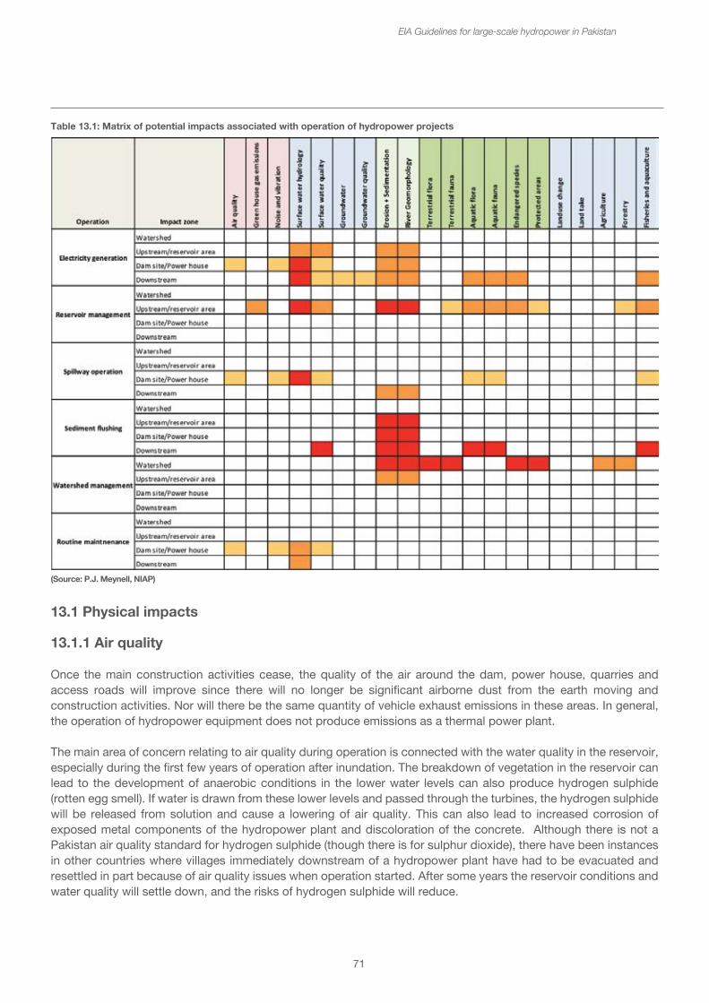
71
EIA Guidelines for large-scale hydropower in Pakistan
Table 13.1: Matrix of potential impacts associated with operation of hydropower projects
(Source: P.J. Meynell, NIAP)
13.1 Physical impacts
13.1.1 Air quality
Once the main construction activities cease, the quality of the air around the dam, power house, quarries and access roads will improve since there will no longer be significant airborne dust from the earth moving and construction activities. Nor will there be the same quantity of vehicle exhaust emissions in these areas. In general, the operation of hydropower equipment does not produce emissions as a thermal power plant.
The main area of concern relating to air quality during operation is connected with the water quality in the reservoir, especially during the first few years of operation after inundation. The breakdown of vegetation in the reservoir can lead to the development of anaerobic conditions in the lower water levels can also produce hydrogen sulphide (rotten egg smell). If water is drawn from these lower levels and passed through the turbines, the hydrogen sulphide will be released from solution and cause a lowering of air quality. This can also lead to increased corrosion of exposed metal components of the hydropower plant and discoloration of the concrete. Although there is not a Pakistan air quality standard for hydrogen sulphide (though there is for sulphur dioxide), there have been instances in other countries where villages immediately downstream of a hydropower plant have had to be evacuated and resettled in part because of air quality issues when operation started. After some years the reservoir conditions and water quality will settle down, and the risks of hydrogen sulphide will reduce.
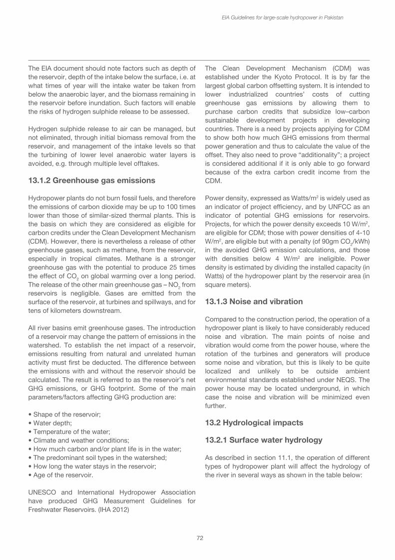
72
The EIA document should note factors such as depth of the reservoir, depth of the intake below the surface, i.e. at what times of year will the intake water be taken from below the anaerobic layer, and the biomass remaining in the reservoir before inundation. Such factors will enable the risks of hydrogen sulphide release to be assessed.
Hydrogen sulphide release to air can be managed, but not eliminated, through initial biomass removal from the reservoir, and management of the intake levels so that the turbining of lower level anaerobic water layers is avoided, e.g. through multiple level offtakes. 13.1.2 Greenhouse gas emissions
Hydropower plants do not burn fossil fuels, and therefore the emissions of carbon dioxide may be up to 100 times lower than those of similar-sized thermal plants. This is the basis on which they are considered as eligible for carbon credits under the Clean Development Mechanism (CDM). However, there is nevertheless a release of other greenhouse gases, such as methane, from the reservoir, especially in tropical climates. Methane is a stronger greenhouse gas with the potential to produce 25 times the effect of CO2 on global warming over a long period. The release of the other main greenhouse gas – NO2 from reservoirs is negligible. Gases are emitted from the surface of the reservoir, at turbines and spillways, and for tens of kilometers downstream.
All river basins emit greenhouse gases. The introduction of a reservoir may change the pattern of emissions in the watershed. To establish the net impact of a reservoir, emissions resulting from natural and unrelated human activity must first be deducted. The difference between the emissions with and without the reservoir should be calculated. The result is referred to as the reservoir’s net GHG emissions, or GHG footprint. Some of the main parameters/factors affecting GHG production are:
• Shape of the reservoir;• Water depth;• Temperature of the water;• Climate and weather conditions;• How much carbon and/or plant life is in the water;• The predominant soil types in the watershed;• How long the water stays in the reservoir;• Age of the reservoir.
UNESCO and International Hydropower Association have produced GHG Measurement Guidelines for Freshwater Reservoirs. (IHA 2012)
EIA Guidelines for large-scale hydropower in Pakistan
The Clean Development Mechanism (CDM) was established under the Kyoto Protocol. It is by far the largest global carbon offsetting system. It is intended to lower industrialized countries’ costs of cutting greenhouse gas emissions by allowing them to purchase carbon credits that subsidize low–carbon sustainable development projects in developing countries. There is a need by projects applying for CDM to show both how much GHG emissions from thermal power generation and thus to calculate the value of the offset. They also need to prove “additionality”; a project is considered additional if it is only able to go forward because of the extra carbon credit income from the CDM.
Power density, expressed as Watts/m2 is widely used as an indicator of project efficiency, and by UNFCC as an indicator of potential GHG emissions for reservoirs. Projects, for which the power density exceeds 10 W/m2, are eligible for CDM; those with power densities of 4-10 W/m2, are eligible but with a penalty (of 90gm CO2/kWh) in the avoided GHG emission calculations, and those with densities below 4 W/m2 are ineligible. Power density is estimated by dividing the installed capacity (in Watts) of the hydropower plant by the reservoir area (in square meters).
13.1.3 Noise and vibration
Compared to the construction period, the operation of a hydropower plant is likely to have considerably reduced noise and vibration. The main points of noise and vibration would come from the power house, where the rotation of the turbines and generators will produce some noise and vibration, but this is likely to be quite localized and unlikely to be outside ambient environmental standards established under NEQS. The power house may be located underground, in which case the noise and vibration will be minimized even further.
13.2 Hydrological impacts
13.2.1 Surface water hydrology
As described in section 11.1, the operation of different types of hydropower plant will affect the hydrology of the river in several ways as shown in the table below:
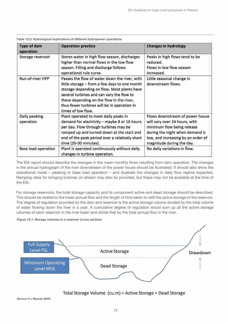
73
Table 13.2: Hydrological implications of different hydropower operations
EIA Guidelines for large-scale hydropower in Pakistan
The EIA report should describe the changes in the mean monthly flows resulting from dam operation. The changes in the annual hydrograph of the river downstream of the power house should be illustrated. It should also show the operational mode – peaking or base load operation – and illustrate the changes in daily flow regime expected. Ramping rates for bringing turbines on stream may also be provided, but these may not be available at the time of the EIA.
For storage reservoirs, the total storage capacity and its component active and dead storage should be described. This should be related to the mean annual flow and the length of time taken to refill the active storage of the reservoir. The degree of regulation provided by the dam and reservoir is the active storage volume divided by the total volume of water flowing down the river in a year. A cumulative degree of regulation would sum up all the active storage volumes of each reservoir in the river basin and divide that by the total annual flow in the river.
(Source: P.J. Meynell, NIAP)
Figure 13.1: Storage volumes in a reservoir (cross section)
74
Changes in flow regime have important consequences for the geomorphology, habitats and ecosystem services of the river, its fisheries and downstream water users. The EIA should provide an analysis of the impacts of these changes downstream. Environmental flow assessments provide a greater understanding of the downstream flow requirements and thresholds. Mitigation in terms of flow management may be possible, e.g. through seasonal flow releases to maintain river channels, or to trigger fish migration. The impacts of rapid changes in flow, e.g. during peak operation that can cause serious bank and bed erosion for kilometers downstream of the power house can be mitigated through appropriate ramping rates.
Box 18: Assessing environmental flows
Flow regime influences the water quality, energy cycles, biotic interactions, and habitat of rivers. It is possible to describe flow regime in terms of five states or environmental flow components, each of which supports specific ecological functions. The health and integrity of river systems ultimately depend on these components, which may vary seasonally:
• Extreme low flows occur during drought. Extreme low flows are associated with reduced connectivity and limited species migration. During a period of natural extreme low flows, native species are likely to out-compete exotic species that have not adapted to these very low flows. Maintaining extreme low flows at their natural level can increase the abundance and survival rate of native species, improve habitat during drought, and increase vegetation.
• Low flows, sometimes called base flows, occur for the majority of the year. Low flows maintain adequate habitat, temperature, dissolved oxygen, and chemistry for aquatic organisms; drinking water for terrestrial animals; and soil moisture for plants. Stable low flows support feeding and spawning activities of fish, offering both recreational and ecological benefits.
• High flow pulses occur after periods of precipitation and are contained within the natural banks of the river. High flows generally lead to decreased water temperature and increased dissolved oxygen. These events also prevent vegetation from invading river channels and can wash out plants, delivering large amounts of sediment and organic matter downstream in the process. High flows also move and scour gravels for native and recreational fish spawning and suppress non-native fish populations, algae, and beaver dams.
EIA Guidelines for large-scale hydropower in Pakistan
• Small floods occur every two to ten years. These events enable migration to flood plains, wetlands, and other habitats that act as breeding grounds and provide resources to many species. Small floods also aid the reproduction process of native riparian plants and can decrease the density of non-native species. Increases in native waterfowl, livestock grazing, rice cultivation, and fishery production have also been linked to small floods.
• Large floods take place infrequently. They can change the path of the river, form new habitat, and move large amounts of sediment and plant matter. Large floods also disperse plant seeds and provide seedlings with prolonged access to soil moisture. Importantly, large floods inundate connected floodplains, providing safe, warm, nutrient-rich nursery areas for juvenile fish.
Each of these flow components, or events, may be quantified in terms of its:
• Magnitude: the volumetric flow rate or level; for example, 100 cubic meters per second.
• Timing: the time of year during which a flow event occurs; for example, August.
• Duration: how long an event lasts; for example, 3 weeks.
• Frequency: how often the event occurs; for example, every 2–3 years.
• Rate of change: the rate at which flows or levels increase or decrease in magnitude over time; for example, a 0.2 meter-per-day flood recession rate.
Environmental flow prescriptions, or recommendations, are often expressed in these terms.
Some of the comprehensive methods used to prescribe river, which account for seasonal and inter-annual flow variation, needed to support the whole range of ecosystem services that healthy rivers provide include DRIFT (Downstream Response to Imposed Flow Transformation), BBM (Building Block Methodology), and the "Savannah Process" for site-specific environmental flow assessment, and ELOHA (Ecological Limits of Hydrologic Alteration) for regional-scale water resource planning and management. The "best" method for a given situation depends on the amount of resources and data available, the most important issues, and the level of certainty required.
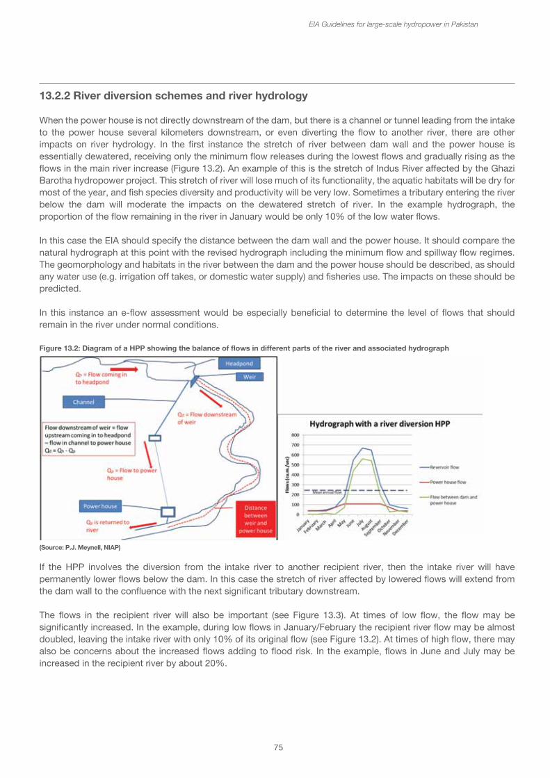
75
13.2.2 River diversion schemes and river hydrology
When the power house is not directly downstream of the dam, but there is a channel or tunnel leading from the intake to the power house several kilometers downstream, or even diverting the flow to another river, there are other impacts on river hydrology. In the first instance the stretch of river between dam wall and the power house is essentially dewatered, receiving only the minimum flow releases during the lowest flows and gradually rising as the flows in the main river increase (Figure 13.2). An example of this is the stretch of Indus River affected by the Ghazi Barotha hydropower project. This stretch of river will lose much of its functionality, the aquatic habitats will be dry for most of the year, and fish species diversity and productivity will be very low. Sometimes a tributary entering the river below the dam will moderate the impacts on the dewatered stretch of river. In the example hydrograph, the proportion of the flow remaining in the river in January would be only 10% of the low water flows.
In this case the EIA should specify the distance between the dam wall and the power house. It should compare the natural hydrograph at this point with the revised hydrograph including the minimum flow and spillway flow regimes. The geomorphology and habitats in the river between the dam and the power house should be described, as should any water use (e.g. irrigation off takes, or domestic water supply) and fisheries use. The impacts on these should be predicted.
In this instance an e-flow assessment would be especially beneficial to determine the level of flows that should remain in the river under normal conditions.
If the HPP involves the diversion from the intake river to another recipient river, then the intake river will have permanently lower flows below the dam. In this case the stretch of river affected by lowered flows will extend from the dam wall to the confluence with the next significant tributary downstream.
The flows in the recipient river will also be important (see Figure 13.3). At times of low flow, the flow may be significantly increased. In the example, during low flows in January/February the recipient river flow may be almost doubled, leaving the intake river with only 10% of its original flow (see Figure 13.2). At times of high flow, there may also be concerns about the increased flows adding to flood risk. In the example, flows in June and July may be increased in the recipient river by about 20%.
EIA Guidelines for large-scale hydropower in Pakistan
Figure 13.2: Diagram of a HPP showing the balance of flows in different parts of the river and associated hydrograph
(Source: P.J. Meynell, NIAP)
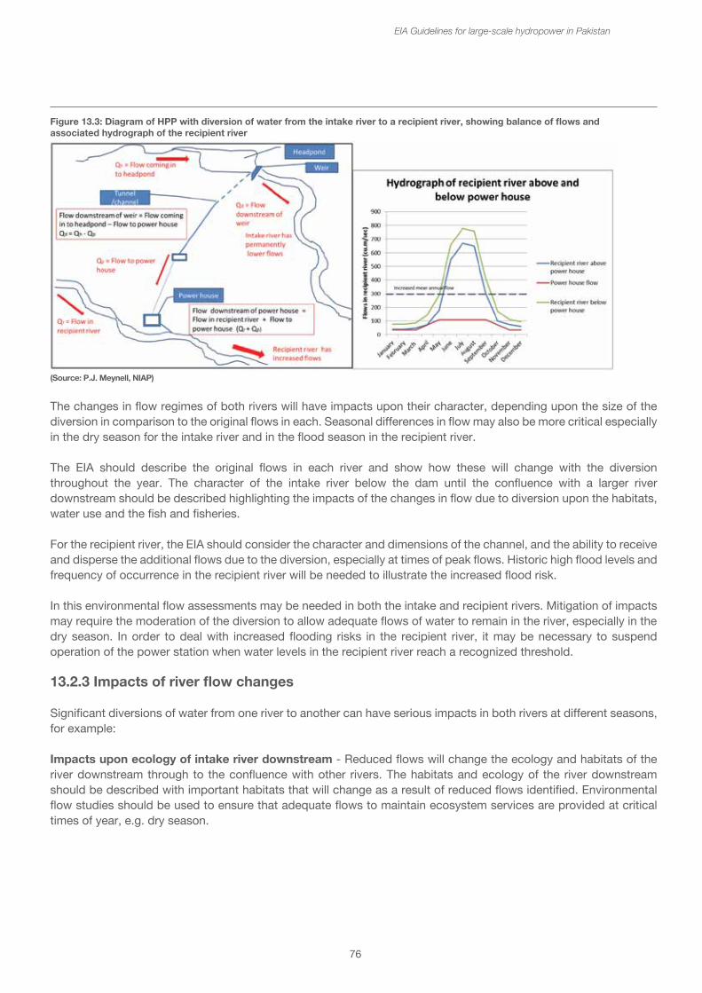
76
The changes in flow regimes of both rivers will have impacts upon their character, depending upon the size of the diversion in comparison to the original flows in each. Seasonal differences in flow may also be more critical especially in the dry season for the intake river and in the flood season in the recipient river.
The EIA should describe the original flows in each river and show how these will change with the diversion throughout the year. The character of the intake river below the dam until the confluence with a larger river downstream should be described highlighting the impacts of the changes in flow due to diversion upon the habitats, water use and the fish and fisheries.
For the recipient river, the EIA should consider the character and dimensions of the channel, and the ability to receive and disperse the additional flows due to the diversion, especially at times of peak flows. Historic high flood levels and frequency of occurrence in the recipient river will be needed to illustrate the increased flood risk.
In this environmental flow assessments may be needed in both the intake and recipient rivers. Mitigation of impacts may require the moderation of the diversion to allow adequate flows of water to remain in the river, especially in the dry season. In order to deal with increased flooding risks in the recipient river, it may be necessary to suspend operation of the power station when water levels in the recipient river reach a recognized threshold.
13.2.3 Impacts of river flow changes
Significant diversions of water from one river to another can have serious impacts in both rivers at different seasons, for example:
Impacts upon ecology of intake river downstream - Reduced flows will change the ecology and habitats of the river downstream through to the confluence with other rivers. The habitats and ecology of the river downstream should be described with important habitats that will change as a result of reduced flows identified. Environmental flow studies should be used to ensure that adequate flows to maintain ecosystem services are provided at critical times of year, e.g. dry season.
EIA Guidelines for large-scale hydropower in Pakistan
Figure 13.3: Diagram of HPP with diversion of water from the intake river to a recipient river, showing balance of flows andassociated hydrograph of the recipient river
(Source: P.J. Meynell, NIAP)
77
Impacts upon fisheries of intake river downstream - With less water in the river at critical times of year, the fish species and productivity of the river will decline. Communities and households that depend upon fishing as an income and provision of food for the household will suffer. The fish and fisheries dependent upon this stretch of river should be described including the seasonality of fish spawning and fisheries activities. The EIA should assess the reduction in fish species and fisheries production as a result of reduced flows. Compensation for downstream fishermen for loss of livelihoods and provision of alternative livelihood and sources of fish in nutrition should be considered.
Impacts upon water users in the intake river downstream – If the length of dewatered river is long, there may be significant impacts upon water availability for water users, e.g. for irrigation, drinking water and for recreational use of the river. The EIA baseline information should include an inventory of all water/river users in the stretch between the dam and the power house or until the confluence with the next major river. The quantities and seasonality of water used should be estimated and the availability of water in the river to meet future demand when required should be assessed.
Downstream erosion of the recipient river due to increased or peaking flows - With increased flows in the recipient river at all times of year, there is potential for increased erosion of river banks and bed, especially if the power house is operated to meet peak demand. The morphology and habitats of the river downstream of the power house and the likelihood of erosion should be assessed for at least 10 km downstream. The added contribution of the water from the power house at different seasons to the flow in the recipient river should be assessed and daily changes, if operating in peaking mode. It may be necessary to modify of flows at different times of year to minimize risks of bank and bed erosion. Banks may be strengthened as required.
Impacts upon ecology of the recipient river downstream of the power house - Increasing flows will lead to increased water levels. This will change the balance of the different habitats in the river, especially sand banks and in-channel wetland areas. It may also increase ground water levels downstream of the power house. The morphology and habitats of the recipient river should be described, and any changes that may occur due to increased flows and raised water levels assessed. Mitigation measures are unlikely to be possible.
EIA Guidelines for large-scale hydropower in Pakistan
Impacts upon fisheries of the recipient river downstream - More water does not necessarily mean more fish. The impacts on the fish will be related to changes in the habitats, especially spawning and nursery areas. The fish species and fisheries activities and production in the recipient river downstream of the power house should be described, including important areas for fish and for fishing, e.g. deep pools, riffles and in-channel wetlands. The impacts of the increased flows upon fish and fisheries should be assessed.
13.3 Water quality
13.3.1 Surface water quality
Water quality issues during operation may occur in both the reservoir and in the downstream water below the power house. When a reservoir is created, the free-flowing river is changed to a very slowly moving lake. There will be less aeration of the water compared to a river, and the biological breakdown of residual vegetation and organic matter brought in from upstream will tend to deplete the oxygen levels in the lower levels of the reservoir. In many reservoirs a thermocline may develop with colder anoxic water kept at the bottom and only the top few meters containing dissolved oxygen. This especially occurs in deep, steep-sided, narrow reservoirs, where mixing is restricted.
At certain times of year, this thermocline may break up, e.g. when a flush of cold water runs into the reservoir sinking to the bottom quickly which “turns over” the reservoir. This brings the poor quality anoxic water to the surface, and may cause fish kills. If this occurs near the water intake, poor quality water may pass on down through the turbines and into the river downstream.
The intake itself may be located at a relatively low level in the reservoir, e.g. near the minimum operating level. When the reservoir is near the top level, the intake may be many meters below the surface and would thus tend to take in poorer quality water. After turbining, this poor quality water will be released downstream, causing water pollution problems downstream.
78
The EIA should address the issue of water quality drawing upon information collected during the baseline survey, especially the water quality entering the reservoir from the different tributaries upstream. An assessment should be made of the likelihood of thermocline formation and seasonal break up (using the characteristics of the reservoir shape and depth), and risks of poor water quality being passed from the reservoir into the river downstream. For the most part the concern is with water with depleted oxygen content and parameters associated with anaerobic breakdown of organic matter, e.g. ammonia, oxides of nitrogen and hydrogen sulphide.
Another water quality issue to be considered are the nutrients, nitrate and phosphate, which may give rise to algal blooms in the reservoir. The risks of algal blooms may be assessed from the nutrient input from the catchment e.g. from sewage, livestock farming and intensive agriculture. If these are found discharging into the rivers above the reservoir, some treatment may be required to minimize the risks of algal blooms. Algal blooms also contribute to the organic matter in the reservoir water, and to oxygen depletion as they breakdown.
Mitigation measures, which may be considered if the risks of poor water quality in both reservoir and downstream are high, include multiple level intakes so that the water entering the penstock is always taken from the better quality reservoir water at levels nearer the surface. Alternatively re-aeration weirs may be included in the downstream tailrace or discharge channels.
13.3.2 Floating objects in the reservoir
One of the biggest reservoir management issues for dam operators is the exclusion and collection of floating debris and preventing it from passing through the intake, down the penstock and damaging the turbines. Reservoirs that have a high amount of vegetation to be cleared before inundation are particularly prone to logs, branches and other vegetation. If there is extensive forest and logging activities in the catchment, there may also be a floating debris problem. In parts of the Indus Valley, the river itself has been a transportation route for both legal and illegally cut logs. If there are major towns located on the rivers above the dam, there could be issues of bottles and plastic trash to be cleared.
EIA Guidelines for large-scale hydropower in Pakistan
Normally intakes are protected by a series of screens that can be raked clear, and operators may have log collection campaigns to reduce the quantity of debris reaching the intake. The disposal of the floating debris requires suitable management, e.g. recovery of timber, provision of firewood, commercial use, e.g. for firing cement or brick kilns.
13.4 Groundwater
The hydrostatic pressure created by the head of a large reservoir may be transmitted through the ground water to areas downstream of the dam. This may cause the groundwater levels to rise depending upon the geology and groundwater characteristics. This has been known to cause water logging and soil salinization downstream of the dam. The EIA should consider the risks of this happening, with reference to previous experience within the region.
13.4.1 Groundwater quality
If there are risks of raised ground water levels there could be an associated decrease in ground water quality, with implications for drinking water. One of the specific issues that has occurred with some dams, has been the mobilization of arsenic from the soils into the ground water. The EIA may consider the arsenic levels in groundwater if geological, hydrological and soil chemistry conditions indicate this as an issue.
13.5 Erosion and Sedimentation
The accumulation of sediments in the reservoir can shorten the effective life of the hydropower scheme by filling up both dead and active storage, and by affecting the overall dam safety. Apart from the initial mobilization of sediments along the shores of the reservoir during impoundment, most of the sediments come from soil erosion in the catchment, and they are carried into the reservoir at times of high flow in the rivers and tributaries. The quantity of sediments carried in rivers originating in the Himalayan and Karakorum mountain ranges is very significant. The Indus is considered to carry about 475 million tonnes of sediment per year. However estimates for sediment transport are very difficult and often unreliable, and often the projections for sediment accumulation in reservoirs have been significantly underestimated in reality.
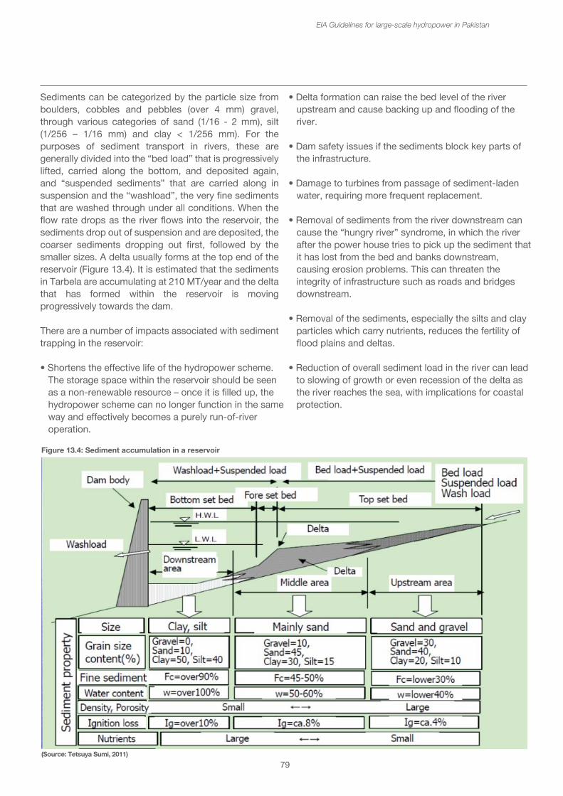
79
Sediments can be categorized by the particle size from boulders, cobbles and pebbles (over 4 mm) gravel, through various categories of sand (1/16 - 2 mm), silt (1/256 – 1/16 mm) and clay < 1/256 mm). For the purposes of sediment transport in rivers, these are generally divided into the “bed load” that is progressively lifted, carried along the bottom, and deposited again, and “suspended sediments” that are carried along in suspension and the “washload”, the very fine sediments that are washed through under all conditions. When the flow rate drops as the river flows into the reservoir, the sediments drop out of suspension and are deposited, the coarser sediments dropping out first, followed by the smaller sizes. A delta usually forms at the top end of the reservoir (Figure 13.4). It is estimated that the sediments in Tarbela are accumulating at 210 MT/year and the delta that has formed within the reservoir is moving progressively towards the dam.
There are a number of impacts associated with sediment trapping in the reservoir:
• Shortens the effective life of the hydropower scheme. The storage space within the reservoir should be seen as a non-renewable resource – once it is filled up, the hydropower scheme can no longer function in the same way and effectively becomes a purely run-of-river operation.
• Delta formation can raise the bed level of the river upstream and cause backing up and flooding of the river.
• Dam safety issues if the sediments block key parts of the infrastructure.
• Damage to turbines from passage of sediment-laden water, requiring more frequent replacement.
• Removal of sediments from the river downstream can cause the “hungry river” syndrome, in which the river after the power house tries to pick up the sediment that it has lost from the bed and banks downstream, causing erosion problems. This can threaten the integrity of infrastructure such as roads and bridges downstream.
• Removal of the sediments, especially the silts and clay particles which carry nutrients, reduces the fertility of flood plains and deltas.
• Reduction of overall sediment load in the river can lead to slowing of growth or even recession of the delta as the river reaches the sea, with implications for coastal protection.
EIA Guidelines for large-scale hydropower in Pakistan
Figure 13.4: Sediment accumulation in a reservoir
(Source: Tetsuya Sumi, 2011)
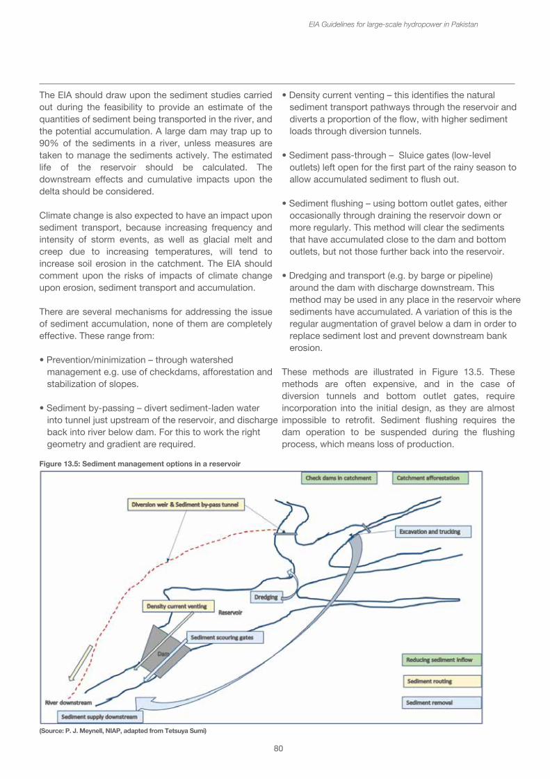
• Delta formation can raise the bed level of the river upstream and cause backing up and flooding of the river.
• Dam safety issues if the sediments block key parts of the infrastructure.
• Damage to turbines from passage of sediment-laden water, requiring more frequent replacement.
• Removal of sediments from the river downstream can cause the “hungry river” syndrome, in which the river after the power house tries to pick up the sediment that it has lost from the bed and banks downstream, causing erosion problems. This can threaten the integrity of infrastructure such as roads and bridges downstream.
• Removal of the sediments, especially the silts and clay particles which carry nutrients, reduces the fertility of flood plains and deltas.
• Reduction of overall sediment load in the river can lead to slowing of growth or even recession of the delta as the river reaches the sea, with implications for coastal protection.
80
The EIA should draw upon the sediment studies carried out during the feasibility to provide an estimate of the quantities of sediment being transported in the river, and the potential accumulation. A large dam may trap up to 90% of the sediments in a river, unless measures are taken to manage the sediments actively. The estimated life of the reservoir should be calculated. The downstream effects and cumulative impacts upon the delta should be considered.
Climate change is also expected to have an impact upon sediment transport, because increasing frequency and intensity of storm events, as well as glacial melt and creep due to increasing temperatures, will tend to increase soil erosion in the catchment. The EIA should comment upon the risks of impacts of climate change upon erosion, sediment transport and accumulation.
There are several mechanisms for addressing the issue of sediment accumulation, none of them are completely effective. These range from:
• Prevention/minimization – through watershed management e.g. use of checkdams, afforestation and stabilization of slopes.
• Sediment by-passing – divert sediment-laden water into tunnel just upstream of the reservoir, and discharge back into river below dam. For this to work the right geometry and gradient are required.
• Density current venting – this identifies the natural sediment transport pathways through the reservoir and diverts a proportion of the flow, with higher sediment loads through diversion tunnels.
• Sediment pass-through – Sluice gates (low-level outlets) left open for the first part of the rainy season to allow accumulated sediment to flush out.
• Sediment flushing – using bottom outlet gates, either occasionally through draining the reservoir down or more regularly. This method will clear the sediments that have accumulated close to the dam and bottom outlets, but not those further back into the reservoir.
• Dredging and transport (e.g. by barge or pipeline) around the dam with discharge downstream. This method may be used in any place in the reservoir where sediments have accumulated. A variation of this is the regular augmentation of gravel below a dam in order to replace sediment lost and prevent downstream bank erosion.
These methods are illustrated in Figure 13.5. These methods are often expensive, and in the case of diversion tunnels and bottom outlet gates, require incorporation into the initial design, as they are almost impossible to retrofit. Sediment flushing requires the dam operation to be suspended during the flushing process, which means loss of production.
EIA Guidelines for large-scale hydropower in Pakistan
Figure 13.5: Sediment management options in a reservoir
(Source: P. J. Meynell, NIAP, adapted from Tetsuya Sumi)
81
It should assess the risks of bank erosion from a knowledge of the character of the river channel, the likely changes in daily and seasonal flows and the stream power of the river downstream.
13.6 Terrestrial ecosystems
13.6.1 Terrestrial flora and fauna
After the completion of construction works and creation of the reservoir, no further land take or inundation will occur and the terrestrial flora and fauna will have an opportunity to recover from the disturbance. However there are several other disturbance factors that will continue, which include:
• Increased access into protected areas through remaining access roads to the dam site and maintenance routes for transmission line, and also boat access up the reservoir. This can increase hunting pressure, illegal logging and the wildlife trade.
• Creation of barriers for movements and migration of land animals - Reservoirs that extend up long valleys can create barriers to the movement of wildlife which would previously been able to cross over the river, especially in the dry season. This is important in protected areas, where a reservoir will add to fragmentation of the PA into smaller parts.
Using the baseline ecological information, the EIA should describe the wildlife habitat on each side of the river valley, and the types of animals likely to be found there. It should consider their range requirements and need to move between both sides of the river. It should estimate how significant the barrier is likely to be for animal movements. If the reservoir is extensive mitigation for animal movements is unlikely to be possible and compensation payments for improved management of the PA may be considered.
There may also be opportunities for enhancing biodiversity conservation as the disturbed terrestrial habitat stabilizes. Large islands in the reservoir may provide interesting refuges for some flora and fauna, although there is some evidence to show that the biodiversity of islands in reservoirs isolated from the surrounding area tends to go down over a number of years. The opportunities for improved protection and conservation of terrestrial fauna and flora should be included in the overall ecological management plan.
EIA Guidelines for large-scale hydropower in Pakistan
The environmental impacts of sediment flushing may also be serious, because the water used for sediment flushing will have a very high sediment load (Total Suspended Solids) and this will tend to smother downstream habitats, and kill aquatic animals, e.g. fish by blocking their gills. Also when sediments are flushed, toxic elements, e.g. mercury, may be mobilized, and passed downstream. The presence of gold mining in a river (both artisanal and medium scale dredging) may indicate higher than normal levels of mercury in the sediments.
13.5.1 Geomorphology changes in the river downstream
The presence of the dam and the changes in the flow regime can alter the river downstream changing the geomorphology and habitats. Scouring of the river bed and erosion of the river bank can result from the marked changes in flow associated with daily peaking regimes and the reduction of sediment load. This can occur for many kilometers downstream until the river has dissipated its energy (stream power) or has acquired a suspended solid load that is appropriate for rate of flow.Stream power is the rate the energy of flowing water is expended on the bed and banks of a channel or the potential for flowing water to perform geomorphic work. Stream power is the power available to transport sediment load, on the stream discharge and the slope. High stream power values generally correspond with steep, straight, scoured reaches, and bedrock gorges. Low stream power values occur in broad alluvial flats, floodplains, and slowly subsiding areas, where the valley fill is usually intact and deepening. Increasing the channel slope or discharge raises stream power values, thus the ability of channel to incise its bed. Greater sediment loads will deter incision to some extent, but the amount and quality of alluvial cover will drive changes in the profile and river form.
The extent to which bed and bank erosion occurs will depend upon the geology and character of the river channel. In a bedrock controlled channel any sand deposits will be stripped away, but the bed-rock itself will resist such erosion. In an alluvial channel, the bed will be down-cut and banks eroded. This process will be compounded by sand and gravel extraction from the river bed. The EIA should consider the character of the river channel downstream for at least 10 – 50 km depending upon the size of the river and hydropower project. It should compare the estimates of suspended solids content in the river before the dam and estimate what it is likely to be afterwards.
It should assess the risks of bank erosion from a knowledge of the character of the river channel, the likely changes in daily and seasonal flows and the stream power of the river downstream.
13.6 Terrestrial ecosystems
13.6.1 Terrestrial flora and fauna
After the completion of construction works and creation of the reservoir, no further land take or inundation will occur and the terrestrial flora and fauna will have an opportunity to recover from the disturbance. However there are several other disturbance factors that will continue, which include:
• Increased access into protected areas through remaining access roads to the dam site and maintenance routes for transmission line, and also boat access up the reservoir. This can increase hunting pressure, illegal logging and the wildlife trade.
• Creation of barriers for movements and migration of land animals - Reservoirs that extend up long valleys can create barriers to the movement of wildlife which would previously been able to cross over the river, especially in the dry season. This is important in protected areas, where a reservoir will add to fragmentation of the PA into smaller parts.
Using the baseline ecological information, the EIA should describe the wildlife habitat on each side of the river valley, and the types of animals likely to be found there. It should consider their range requirements and need to move between both sides of the river. It should estimate how significant the barrier is likely to be for animal movements. If the reservoir is extensive mitigation for animal movements is unlikely to be possible and compensation payments for improved management of the PA may be considered.
There may also be opportunities for enhancing biodiversity conservation as the disturbed terrestrial habitat stabilizes. Large islands in the reservoir may provide interesting refuges for some flora and fauna, although there is some evidence to show that the biodiversity of islands in reservoirs isolated from the surrounding area tends to go down over a number of years. The opportunities for improved protection and conservation of terrestrial fauna and flora should be included in the overall ecological management plan.
82
13.6.6 Forestry
There are unlikely to be further losses in the extent of forests after completion of the dam and inundation. However improved access to the catchment may increase the incidence of illegal logging. By contrast, watershed management programmes may involve replanting and afforestation.
13.7 Aquatic ecosystems
13.7.1 Ecological changes in the reservoir
The construction of a dam across a river changes the area behind it from a free flowing river into a slowly moving lake. The river habitats are lost, transformed into lacustrine habitats.
Using information of the height of the dam and expected top water level, and the topography of the river and bank above the dam, estimate the area to be inundated and the length of river above the dam. Describe the habitat features in the river to be inundated, e.g. deep pools, gravel beds, rapids and riffles, sand bars and in-channel wetlands, seasonally inundated by high water levels and assess their extent. The lengths and character of the principal tributaries flowing into the main river should also be estimated.
These areas may have been noted as fish spawning, breeding and nursery grounds. It is likely that inundation of these habitats will result in loss. The river fish will have to find alternatives for spawning and nursery areas or populations of these fish will decrease. Sand bars and banks are also important for breeding turtles, and for some nesting birds. The main fish species using the habitat should be identified, especially if migratory, also special aquatic species such as turtles. Indicate the presence of these habitats in other stretches of the river upstream and downstream. Indicate the main tributaries and seasonal streams coming into the reservoir. Estimate the significance of this loss, e.g. if this is a major spawning area.
These losses are inevitable with inundation and no direct mitigation is possible. If the losses of aquatic habitat are significant, compensatory improvements or protection of aquatic habitats elsewhere may be considered.
EIA Guidelines for large-scale hydropower in Pakistan
13.6.2 Endangered species
After the dam is built and impoundment of the reservoir completed, there will no longer be direct threats to terrestrial endangered species, although increased access to habitats of these species may result in increased hunting pressure.
For aquatic endangered and endemics species, the flow changes, habitat changes and water quality issues described above could add further pressures upon relatively small and vulnerable populations, leading to their reduction or loss from the area, or even global extinction.
The EIA should clearly identify any such endangered species that are likely to be affected, and where the impacts could lead to extirpation from the area or extinction, a species conservation plan should be developed.
13.6.3 Protected areas
Once the dam and reservoir are in place, the impacts upon protected areas resulting from inundation and fragmentation will have taken effect as described earlier. The issues of increased access to the protected area from new roads and boats on the reservoir giving rise to increases in illegal hunting and the wildlife trade will persist and require increased management and enforcement. The contribution to strengthened management of the protected area by the dam operator would be expected as a form of compensation – see box no. 16.
13.6.4 Land take and Landuse change
Once the dam and reservoir are in operation, there are unlikely to be any further land take issues. However, the presence of the dam and reservoir may give rise to some changes in landuse, particularly if water is made available for irrigation. The presence of the access road and nearby resettlement villages may also give rise to localized changes in landuse.
13.6.5 Agriculture
There are unlikely to be further changes in agriculture land although practices may change with introduction of irrigation associated with the dam and livelihood packages for resettled communities.
83
The baseline survey should describe the presence of water weeds, especially invasive species existing in the river already before the construction of the dam. Reduction of nutrient inputs and active measures to prevent water weed build-up may be included as part of good reservoir management. There should be active monitoring and removal of invasive water weeds when found.
13.7.3 Reservoir fish and fisheries
With the change from a free flowing river to a reservoir, the fish species diversity will change in the following ways:
• Fish that are able to live and breed in the still water habitats of the reservoir will thrive.
• Populations of pelagic (open water) fish species are likely to grow.
• Fish that can live in the reservoir and that continue to have access to spawning grounds in the tributaries and seasonal streams will continue to be found in the reservoir. If they do not have access to these spawning areas they will die out.
• Migratory fish from downstream will be prevented by the dam from moving into the reservoir, unless adequate fish passage is provided.
• Fish that are adapted to living in fast flowing rivers and streams will move out upstream or die out; their population sizes are likely to decrease.
EIA Guidelines for large-scale hydropower in Pakistan
13.7.2 Aquatic flora in the reservoir
Some of the issues for reservoir management include:
Algal blooms - Algal blooms can develop at certain times of year, especially in the hot seasons, caused by high levels of nutrients in the water. Nutrients can come from the decayed vegetation, from agricultural run-off and from sewage and waste water entering the reservoir.
Algal blooms can cause lowered oxygen content of the water in the reservoir and in some instances, e.g. with blue-green algae may be toxic causing problems for fish and for drinking water supplies. The baseline survey should assess the nutrient levels (Nitrate and Phosphate) in the river water and levels of intensive agriculture within the catchment of the reservoir. Any possible sources of nutrients from sewage or other waste waters entering reservoir should be identified so that the risks of eutrophication of reservoir water can be assessed. Mitigation may be through control of nutrients and sources of pollution coming into the reservoir.
Proliferation of water weeds in reservoirs and downstream - Water weeds may grow and proliferate in the reservoir due to the high nutrient content of the water. Factors such as elevation and climate may also affect the proliferation of water weeds, so that colder, relatively high reservoirs will be less prone to this problem. Invasive aquatic species such as water hyacinth are especially difficult to control, impairing dam discharge. Water weeds may collect and block intakes or spillways and reduce effectiveness and safety of the HPP. Other impacts of water weed build up in the reservoir include impacts on:
• Irrigation schemes - Water weeds may block irrigation intakes and channels.
• Navigation and boat movements - Water weeds may reduce the ability of boats to move on the reservoir. • Fisheries - Water weeds may get caught in nets and fishing gear and damage engines.
• Increasing water loss through transpiration. Water loss through evapo-transiration is likely to increase with growth of water weeds, compared to an open reservoir surface.

The baseline survey should describe the presence of water weeds, especially invasive species existing in the river already before the construction of the dam. Reduction of nutrient inputs and active measures to prevent water weed build-up may be included as part of good reservoir management. There should be active monitoring and removal of invasive water weeds when found.
13.7.3 Reservoir fish and fisheries
With the change from a free flowing river to a reservoir, the fish species diversity will change in the following ways:
• Fish that are able to live and breed in the still water habitats of the reservoir will thrive.
• Populations of pelagic (open water) fish species are likely to grow.
• Fish that can live in the reservoir and that continue to have access to spawning grounds in the tributaries and seasonal streams will continue to be found in the reservoir. If they do not have access to these spawning areas they will die out.
• Migratory fish from downstream will be prevented by the dam from moving into the reservoir, unless adequate fish passage is provided.
• Fish that are adapted to living in fast flowing rivers and streams will move out upstream or die out; their population sizes are likely to decrease.
84
EIA Guidelines for large-scale hydropower in Pakistan
It is likely that the fish species diversity (the numbers of fish species) in the reservoir will decrease, though they may rise again in a big reservoir with increase in pelagic species. However, fish production is likely to increase markedly immediately after inundation, as nutrients become available from the breakdown of vegetation. After a fisheries boom, the fishery production levels will fall over several years, sometimes to a lower level per hectare than in the river before the dam. Figure 13.6 shows the changes projected after the inundation of Lake Kariba on the Zambezi. This shows the changes in nutrient load, fish production and fish diversity, showing that it might be nearly 10 years before the reservoir conditions stabilised.
In order to assess the changes in fish diversity, the fish species found in different sections of the river to be inundated should be identified. The habitat preferences and spawning requirements for each can be recorded, as far as possible, and the species falling into the categories listed above will help to determine what fish populations will develop in the reservoir.
The fish production expressed in kilograms per hectare per year may be projected, based upon production figures from other reservoirs within the region. In tropical reservoirs in South East Asia, fish production in small reservoirs less than 100 ha can be as high as 500 kg/ha per year, but for larger reservoirs of more than 10,000 ha may be as low as 100 kg/ha/year. The productivity tends to vary with size, smaller and shallower reservoirs being more productive.
One mitigation measure often applied is the stocking with with fish fingerlings of species, especially immediately after inundation, in order to take advantage of the boom in productivity. In doing this only native species that are likely to survive in the reservoir should be used, because
of the danger of introducing invasive alien species. There may already be a problem with alien species because fish are likely to escape from fish farms in the area that is inundated, and often these are alien species.
13.7.4 Fisheries and aquaculture
The potential for establishing a commercial or small-scale fishery on the reservoir is often promoted as a form of livelihoods compensation of large hydropower projects. Certainly the presence of a large body of water provides such an opportunity for both, a capture fishery and/or cage aquaculture in the reservoir. Mention has already been made of the boom in fish production that often occurs immediately after impoundment, which over the first few years stabilizes to a lower productivity. Stocking the reservoir with fish is also seen as a way of enhancing fish production in the reservoir, especially if access to spawning sites in seasonal streams and tributaries is limited.
Both reservoir capture fishing techniques, boats and equipment, and cage culture are very different from the
(Source: FAO)
Figure 13.6: Ecological and fisheries changes occurring after the inundation of Lake Kariba on the Zambezi, Africa
85
EIA Guidelines for large-scale hydropower in Pakistan
techniques of the river fishery. Investment and technical support is required to help fishermen develop the skills and knowledge necessary to be successful. Fish landings with good access and marketing structures will also be required. If the development of the reservoir fishery is considered, the EIA should assess the potential and estimate possible sustainable production rates, using examples from other reservoirs within the country. It should also outline the development requirements for establishing such a fishery.
If fish stocking in the reservoir is considered, the development of fish hatcheries and nurseries should be considered, especially using the nullahs above the reservoir for this purpose. It is important that only indigenous species of fish be used for stocking the reservoir, since if alien species are introduced they may become invasive and destroy the natural fish populations.
13.7.5 Aquatic flora and fauna – downstream
There are four principal ways in which the aquatic flora and fauna in the downstream river are affected by a hydropower scheme:
• Changing flow patterns, with both seasonal shifts and daily peaking operations;
• Reduced sediment loads passing through the reservoir and dam;
• Changes in water quality and temperature due to release of colder, poor quality water from the reservoir;
• Barrier effects of the dam, preventing upstream and downstream migration of fish.
The changing flow patterns and the reduced sediment loads change the geomorphology and habitats of the river downstream, the ecosystem services provided by the river and the aquatic flora and fauna. The geomorphological changes are likely to happen over a number of years. Thus, if the flows during the low flow season are increased (sometimes these may be doubled) due to operations of a storage dam, then the parts of the river channel that used to be seasonally flooded and have developed appropriate habitats and ecology (e.g. in-channel wetlands), may become permanently underwater. Gravel beds, important for fish spawning may now occur in deeper water and are less aerated.
If the high flow peaks are reduced, the channel-forming flood flows that occur every two to three years, will no longer occur so frequently, so that the channel may become narrower and sediment deltas that occur at the mouths of tributaries will not be washed away, i.e. the channel may not be able to accept larger flash floods in the future.
Often flash floods early in the high flow season act as triggers to fish migration, and these will tend to be balanced out in a storage dam. Thus such migration triggers may be lost, or moved to later in the season, causing abortive fish migrations.
If the dam is operated to meet peak demands in electricity, then the daily fluctuation from minimum flows to design flows will create downstream river that is rather barren and with only those organisms that are able to survive in these extreme flow conditions, which will be especially apparent during the season of low flows in the river. These daily fluctuations may be observed for many kilometers downstream depending upon the shape, size and character of the channel, and whether there are any other tributaries entering the river downstream, so the potential impacts downstream may be considered for 50 to 100 kms downstream.
The reduced sediment loads passing through the dam, will tend to cause the river to pick up sediment downstream, depending upon its stream power, and cause bed and bank erosion, the reduction in sand banks and loss of alluvial habitats. This may be alleviated if sediment management measures transfers sediment from the reservoir to the downstream reaches, but sediment flushing with the release of high quantities of sediment in a short time, can also be devastating on the river ecology downstream.
Impacts of poor water quality and colder temperatures can also change the aquatic flora and fauna downstream, driving away more sensitive species, and on occasion, causing fish mortalities. This is an issue especially after impoundment of a reservoir when the breakdown of vegetation causes poor water quality, depleted of oxygen, to be passed downstream. As the conditions in the reservoir stabilize, the quality of the water is likely to improve, but occasionally conditions change, e.g. during annual turnover of the thermocline in the reservoir, or if another dam is constructed above the first dam and poor quality water is passed on from upstream. Poor water quality may also act as a barrier to fish migration.
86
EIA Guidelines for large-scale hydropower in Pakistan
Water taken from lower layers in the reservoir can be several degrees colder than the ambient water temperature in the river, and cause thermal shock and even mortality to aquatic flora and fauna and, at best, avoidance of the affected areas of the river by fish that prefer warmer water. As a rule of thumb, there is a 1 deg. C lower temperature for every 10 meters below the surface of the reservoir, so an intake located 30 m below the surface, would be releasing water some 3 deg. C lower than ambient.
The barrier effect of dams to migratory fish is the most well-known impact of large dams. Unless there is provision made for fish passage around the dam, all dams will prevent the free movement of fish between downstream to upstream. Migratory fish species generally move upstream to spawn in suitable locations in smaller rivers and streams – gravel beds and in-channel wetland areas are favored habitats. If the dam prevents migration then these species have to find suitable habitats elsewhere in the river system. As more dams are built, access to suitable spawning sites decreases, and the overall populations of these fish in the downstream will decline and are likely to become lost altogether from upstream reaches.
Fish migration downstream may also be a problem, because passage through the turbines and over spillways is likely to damage the fish internally, due to pressure changes, leading to mortalities. Larger fish are generally excluded from the turbines by trash racks, but fish fry, fingerlings and fish smaller than about 20 cms may pass through the turbines. The so-called “fish friendly turbines” require further development.
In an EIA, the baseline information on the downstream aquatic flora and fauna should include:
• Description of the geomorphology and aquatic habitats downstream of the dam site, and their importance in the overall ecology of the river, e.g. presence of fish spawning and feeding sites. Note that some large waterfalls may act as a natural barrier to fish migration, and the fish species above the waterfall will be very different from those below.
• Description of the fish species present, and a categorization of the fish species according to their behavior (migratory, non-migratory) and habitat preferences. Identify the seasons and triggers of migration if possible.
• Uses of aquatic resources by local communities – plants such as reeds, fish and other aquatic animals.
Depending on the size of the river and dam, downstream baseline information should be collected for at least 50 – 100 kms downstream. Fisheries baseline surveys should be started as soon as possible and continued for several seasons to get a good picture of the seasonal and annual variation. Environmental flow studies should be carried out to determine the flow regime and to make predictions of likely changes resulting from the changed flows after the dam is built. Recommendations should be made for the downstream flow regime to ensure that a healthy river ecology and the ecosystem services it provides are maintained. Apart from the management of flows, very little direct mitigation measures can be taken to retain the habitats and ecologically important stretches of the river downstream, because they are so dependent upon the flow regime.
A range of designs to facilitate the passage of migratory fish are becoming available, from the more conventional vertical slot fish ladders, natural stream by-passes, to fish lifts and transport of migratory fish around the dam. However, none have been proven to be effective for all types and seasons of fish migration, and the design of fish passage needs to be tailored to suit the fish species that will be using it. In general, the higher the dam the less effective the fish passage; fish passage for dams up to about 10 m in height can be designed effectively, but above this extra attention, space, diverted water and cost will be needed and it still may not be effective. Modeling of fish populations in the Mekong passing dams has shown that at least 60% of small fish attempting upstream migration should be able to pass on dam to maintain the populations, and this would rise to between 80 – 95% effectiveness with three dams in cascade.30
Some compensatory stocking of fish may be done in the downstream reaches after construction has been completed, but only native species should be used.
30Halls, A.S. and M. Kashatriya (2009) Modeling the cumulative barrier and passage effects of mainstream hydropower dams on migratory fish populations in the Lower Mekong Basin (MRC Technical Paper No 25). Mekong River Commission, Vientiane.
• Uses of aquatic resources by local communities – plants such as reeds, fish and other aquatic animals.
Depending on the size of the river and dam, downstream baseline information should be collected for at least 50 – 100 kms downstream. Fisheries baseline surveys should be started as soon as possible and continued for several seasons to get a good picture of the seasonal and annual variation. Environmental flow studies should be carried out to determine the flow regime and to make predictions of likely changes resulting from the changed flows after the dam is built. Recommendations should be made for the downstream flow regime to ensure that a healthy river ecology and the ecosystem services it provides are maintained. Apart from the management of flows, very little direct mitigation measures can be taken to retain the habitats and ecologically important stretches of the river downstream, because they are so dependent upon the flow regime.
A range of designs to facilitate the passage of migratory fish are becoming available, from the more conventional vertical slot fish ladders, natural stream by-passes, to fish lifts and transport of migratory fish around the dam. However, none have been proven to be effective for all types and seasons of fish migration, and the design of fish passage needs to be tailored to suit the fish species that will be using it. In general, the higher the dam the less effective the fish passage; fish passage for dams up to about 10 m in height can be designed effectively, but above this extra attention, space, diverted water and cost will be needed and it still may not be effective. Modeling of fish populations in the Mekong passing dams has shown that at least 60% of small fish attempting upstream migration should be able to pass on dam to maintain the populations, and this would rise to between 80 – 95% effectiveness with three dams in cascade.30
Some compensatory stocking of fish may be done in the downstream reaches after construction has been completed, but only native species should be used.
87
EIA Guidelines for large-scale hydropower in Pakistan
14. Catchment or Watershed Management Plan
The catchment or watershed31 is referred to as the land area above the reservoir that serves as the collection area for all the rainfall and run-off feeding into reservoir. The effectiveness of the catchment area for collecting run-off depends upon the slope and soil conditions and the vegetation cover. In general it is considered that catchments with greater forest cover are better for the conservation of the water resources. There is also greater slope stability and less soil erosion. Since sediment accumulation in the reservoir is a major factor affecting the life of the hydropower project, catchment or water shed management is an important part of the overall management of the project.
The watershed management plan thus covers the land use and soil conservation practices of the whole area above the reservoir. Since this area is rarely uninhabited and used for different forms of agriculture, the watershed management plan should involve the communities that live in these areas. In some cases, the farmers and foresters may receive payments from the hydropower project to manage their land use practices in such a way that encourages the conservation of water resources and minimizes soil erosion – a form of payment for environmental services (PES).
The Watershed Management Plan should describe the area above the reservoir, its geology and soil characteristics, slope and stability. The sources of water and drainage patterns of small seasonal streams feeding into the permanent streams and main river should be mapped and described. The vegetation cover should be mapped and described, including the dominant tree species, woodland, scrub and ground cover. If the area also includes a Protected Area this should be described, together with the main fauna and endangered and endemic species. The conservation measures of a Protected Area usually contribute towards the same objectives as the watershed management plan.
The population and communities in the catchment should be mapped and described, including their main livelihood and income generating mechanisms. The main crops, extent and seasonal patterns of cultivation shouldbe covered, including slash and burn techniques
31In this context catchment and watershed are used interchangeably, however the term catchment is more descriptive of the function of the area collecting or catching the water. In some usage, watershed is the top line of the hill or ridge where the water flows into the river basin. The river basin is the whole river and its catchment from source to sea. The sub-basin is the catchment of a tributary from source to confluence with the mainstream river.
aswell as more permanent cultivation methods. Livestock may be an important factor in determining the vegetation cover, with overstocking of cattle, sheep and goats contributing to degradation of the catchment. Infrastructure and access roads should also be noted and mapped.
The management actions that may be considered include the construction of check dams along seasonal streams to slow the rate of flow of water after heavy rainfall and check or collect the sediment. Protection of the vegetation cover or replanting of trees at critical places where soil is liable to be eroded may be important. Often the afforestation is the most usual form of watershed management, though the practice of agro-forestry plantations may also lead to increased soil erosion. Cultivation practices that tend to enhance soil conservation should be encouraged, and those that lead to increased soil erosion discouraged. Livestock numbers may need to be reduced and animal husbandry practices may be introduced that enhance productivity of fewer animals.
Box 19: WWF proposes an ecological conservation plan for Diamer Bhasha Dam
At the invitation of WAPDA, in 2012 WWF-Pakistan proposed a partnership for the restoration of the ecology of the catchment areas linked to the Diamer Basha Dam Project. This Project provides a unique opportunity to conserve and restore the natural forests that lie in the catchment area of the water reservoir. This would be done by developing a valley/sub-watershed based conservation plan that will be implemented by mobilizing the local communities and organizing them into a Community Based Organisation and providing them training. The conservation plans will be implemented in five to eight high priority valleys and will focus on four main areas: forest, wildlife, freshwater and pastures. These conservation areas will be further complemented by ecotourism initiatives, an information centre and research. These high priority valleys will be selected on the basis of a thorough assessment and community engagements that will be carried out during the inception phase of the project. The Gilgit - Baltistan region, in general with its catchment areas, contains significant natural forests, flagship and endangered species of wildlife. This region covers two important ecoregions: Karakarum West Tibetan Plateau Alpine Steppe and Western Himalayan Ecoregion. These ecoregions are listed in the ranking of the Global 200 ecoregions that have been selected through scientific assessment of critical ecosystems associated with biodiversity.
32World Bank, Energy Sector Management Assistance Program. (December 2012) Sample Guidelines: Cumulative Environmental Impact Assessment for Hydropower Projects in Turkey33Note that if the hydropower project involves diversion of water from one river to another, at least two river basins should be considered.
88
EIA Guidelines for large-scale hydropower in Pakistan
This Ecological Conservation Plan will also set aside a conservation fund of Rs. 50 million for communities to provide minimum support to the respective community based organisations for an agreed conservation plan. The communities may also apply for further funding for specific conservation initiatives, within their respective valley/watershed. A mechanism will be agreed with WAPDA and NEPRA to provide further support to this community conservation fund out of the operation of the Diamer Basha Dam. The project will be monitored by an officially notified steering committee that will meet every six months and will be chaired by a nominee of the Chairman WAPDA.
Source: WWF Pakistan
15. Assessing cumulative impacts of hydropower
Although not formally required in EIA regulations, cumulative impacts of hydropower dams are increasingly being considered as an essential part of best practice in impact assessment. A Cumulative Impact Assessment (CIA) may be prepared as a stand-alone document, or as a section within the main EIA. The IFC Good Practice Handbook of Cumulative Impact Assessment and Management recognizes that CIA is evolving and that there is no single accepted state of global practice. It suggests a six step process for a rapid assessment (RCIA):
1. Determine the spatial and temporal boundaries;
2. Identify valued environmental and social components (VECs) and all developments and external natural and social stressors affecting the VECs;
3. Determine present conditions of the VECs;
4. Assess cumulative impacts;
5. Evaluate their significance over VECs predicted future conditions;
6. Design and implement a) adequate strategies, plans and procedures to manage cumulative impacts, b) appropriate monitoring indicators and c) effective supervision mechanisms.
CIA processes also involve continuous engagement with affected communities, developers and other stakeholders. The IFC’s RCIA process envisages three main outcomes of the assessment of a project:
1. Significant risk for cumulative impacts with significant leverage for developing an appropriate management strategy which other operators/developers and government are likely to follow.
2. Significant risk for cumulative impacts with limited leverage for affecting the behavior of other developments and management of environmental and social stressors.
3. Limited or no contribution to cumulative impacts, in which case the environmental management measures adopted will be the ones identified in the EIA process.
Another more specific guide for assessing the cumulative impacts of hydropower projects has been prepared by the World Bank for application in Turkey.32
Expressed like this, the process of doing a CIA can be seen to complement those of an EIA, and in a way bridges the gap between a Strategic Environmental Assessment, which is usually done on policies, programmes and plans, whilst EIA is carried out on projects. Box no. 20 describes the SEA of hydropower development in AJ&K, illustrating the power of this approach.
In the context of assessing cumulative impacts of an EIA of a large hydropower project, it must be appreciated that the cumulative impacts of several dams in cascade are more than the sum of the impacts of each individual dam. The CIA should focus on comparing the contribution of the project to environmental and social impacts with a) other hydropower projects within the same river basin(s)33 and b) other water using projects within the same river basin(s), including irrigation, water supply, waste water discharge. Thus the key environmental and social parameters to be considered include:
• Changes in flows, both seasonal and diurnal;• Sediment transport; • Water quality;• Availability and allocation of water uses within the river basin(s);• Changes in river connectivity, i.e. increasing numbers and sites of dams as ecological barriers;
89
EIA Guidelines for large-scale hydropower in Pakistan
• Changes in aquatic biodiversity, cumulative loss of important habitats, fish species and productivity;• Fisheries and use of natural resources from the river for livelihoods and income generation.
In addition, if the hydropower project has a large reservoir and there are other large development projects affecting the land, changes in land use within a defined area, e.g. a district or province, may also be an important cumulative parameter. Socio-economic factors that could be considered include resettlement expected within a certain time frame, e.g. 10 years, employment within the district or province, or contribution to the overall economy of the district or province.
Box 20: Recommendation on incorporating cumulative impact assessment into EIAs from Strategic Environmental Assessment of Hydropower Development in AJK
Given the potential for cumulative impacts from the approximately 60 projects currently included in the combined lists of agency development plans, each and every IEE or EIA should be required to consider cumulative impacts as part of environmental assessment studies. In this context, the following requirements for considering the cumulative impacts of projects might be incorporated into Terms of Reference for carrying out full EIA studies:
• Define project activities along with other existing, in progress, or planned projects (for the reasonably foreseeable future) in the region that could contribute to cumulative effects on valued ecosystem components (VECs);
• For uncertain cases, scenarios can be developed that include (i) definite future actions, (ii) definite future actions plus probable future actions (still involving some uncertainty), (iii) definite future actions plus probable and less probable future actions (with a higher degree of uncertainty);
• Identify the area of influence for the project (which may vary for different types of potential impacts);
• Identify the time boundary for the study, especially with regard to considering actions in the reasonably foreseeable future (e.g., a concomitant construction period or operation). Scenarios can be developed to identify temporal boundaries as well, particularly when there is uncertainty;
• Identify possible VECs in the region in or close to the project’s area of influence;
• Identify the VECs in the area of influence that should be considered in the study based on information related to current or anticipated future conditions, the existence of protected species or habitats, and the presence or anticipated presence of other human activities that would (adversely) affect the VECs;
• Identify project-specific standards (PSS), including relevant regulatory and/or international thresholds and standards.
16. Transboundary impacts
The impacts of hydropower projects often cross-administrative boundaries. One of the common failings of EIAs is that the studies focus on the immediate impact zones of the construction site and reservoir area, but do not consider the wider implications of the project. Transboundary impacts are generally those that are felt in a different country or in a different province to the country or province where the project is located and regulated. The country or province(s) that experience these transboundary impacts may thus be “paying” through environmental degradation or social impacts, for a development that they can neither control nor receive any benefits from.
The EIA of a large hydropower project should therefore consider transboundary impacts in a separate section of the EIA report, and show how these may be addressed.
Rivers often flow through a number of different administrative boundaries, and the main transboundary impacts resulting from hydropower projects relate to the changing flows and quality of water, and also the transport of sediment. They may also relate to migratory fish, and the impacts on downstream fisheries.
Thus transboundary impact assessment should be considering at least the following aspects:
• The impacts downstream of seasonal changes in the flow regime which will affect the availability of water for downstream water users at different times of year;
• The distance downstream of daily changes in flow due to peaking operations;
90
EIA Guidelines for large-scale hydropower in Pakistan
• The increased control of floods that large storage dams can provide (a benefit), combined with the risks of large flood events due to storms when the reservoirs are full and spillways have to be used unexpectedly;
• The loss of sediment being transported downstream and the increased incidence of bed and bank erosion, especially in alluvial reaches of the river, with potential damage to roads and bridges and other infrastructure;
• The reduction in sediment reaching marine deltas resulting in changes in the dynamics of the delta and possible regression;
• Effects of occasional releases of poor water quality upon domestic, agricultural and industrial water supplies downstream and aquatic life;
• Reduction in the populations of migratory fish unable to reach spawning and nursery grounds upstream;
• Implications for downstream fisheries operations and livelihoods.
The assessment will have to consider how far downstream these effects will be felt, and also what other water users – hydropower plants, irrigation schemes, waste water discharges etc. – are also contributing to the issue. It is rare that one hydropower plant is the cause of all the impacts and so transboundary assessment should also be combined with a cumulative impact assessment.
Because transboundary impacts occur in different administrative jurisdictions, it may be necessary to consult with and obtain the necessary approvals or no objections from the provinces or countries downstream. There may be significant legal issues, especially relating to water rights, but also responsibility for damages downstream, e.g. resulting from a water pollution incident from the hydropower project. Reference to the documents coming out of the Espoo Convention on transboundary impact assessment may be helpful in this regard.
Box 21: Transnational impacts of changing flows from the Kishanganga Dam
In the Indian state of Jammu and Kashmir, the construction work on the 330 MW Kishanganga Hydroelectric Plant project has started, after being defunct for eighteen years. The project involves damming of Kishanganga or Neelam River and the reservoir will submerge some parts of the Gurez Valley of Kashmir. The water of Kishanganga River will be diverted through a 24 kilometer tunnel dug through the mountains to Bandipore where it will join the Wular Lake and then Jhelum River.
Similarly, Pakistan is constructing the 969 MW Neelum–Jhelum Hydropower Plant and claims that the Kishanganga Dam would result in 14 percent decrease in the flow of water for its hydropower project. Pakistan claims that the Indian dam project will violate the Indus Waters Treaty and has pursued formal arbitration proceedings against India over the matter. In December 2013, the International Court of Arbitration (ICA) allowed India to build Kishanganga Dam in the occupied Kashmir, however, India has been ordered to provide half of the dam’s water to Pakistan. The court also ruled that India cannot take the water on a very low level in the dam.
Environmental flow studies were carried out which enabled Pakistan to submit detailed facts and figures regarding water flow to the court. In its Partial Award in the Indus Water Kishanganga Arbitration (Pakistan v. India), (18 February 2013), the Permanent Court of Arbitration strongly endorsed the existence of a requirement to ensure ecological flows under generally applicable customary international law. Relying on the principle of sustainable development and the duty to prevent significant transboundary harm, the Court found that ‘India’s duty to ensure that a minimum flow reaches Pakistan also stems from the [1960 Indus Waters] Treaty’s interpretation in the light of customary international law’. In so doing, it declared that ‘[i]t is established that principles of international environmental law must be taken into account even when … interpreting treaties concluded before the development of that body of law’.
Source: Pakistan Observer, Sunday, December 22, 2013
91
EIA Guidelines for large-scale hydropower in Pakistan
17. Dam safety and disaster management
Dam safety is a major concern for both operators and regulators. All aspects of the World Bank Operational Policy (OD/GP 4.37) for the safety of dams should be reflected by developers and operators, including required reviews by an independent panel of experts of the investigation, design and construction of the dam and start of operations and sub‐plans (i) a construction supervision plan (ii) a quality assurance plan (iii) an instrument plan (iv) an operation and maintenance (O&M) plan, and (v) an emergency preparedness plan (EPP).34
Pakistan has established within WAPDA, the Dams Safety Organisation,35 which is responsible for programmed monitoring of existing and future dams:
Box 22: Dams Safety Organization
Most of the high dams in Pakistan lie above thickly populated areas and rich agricultural lands. Failure of any such dam could spell a disaster and irreparable loss of life and property. In order to minimize the chances of such failures, systematic monitoring of their performance has been considered imperative. Dams Safety Organization (DSO) is responsible for implementation of this programmed monitoring for completed dams with WAPDA namely: Mangla Dam, Tarbela Dam, Warsak Dam, Khanpur Dam, Hub Dam and Chashma Barrage.
The dam safety programme consists of Three Tiers. The First Tier monitoring is carried out by the operation and maintenance (O&M) staff of the project. This consists of observing the responses of the vast network of instruments embedded in the various structures. The data collected thus is compiled and analyzed to identify the areas of abnormal behavior and to devise measures for immediate action.
The Second Tier monitoring is carried out by DSO. It is done by keeping a constant watch on the flow of instrument response data of the project structures through Tier One, analyzing it using the latest interpretation techniques, locating the areas of abnormal behavior and suggesting short term and long term solutions. DSO also undertakes annual inspections to see the physical condition of the works and to make on site appraisal of performance data. At the end of the inspection, a comprehensive report is issued commenting upon the physical condition of the works, abnormalities observed, their likely causes and possible solutions. Its experts also visit projects, whenever any
abnormal situation is reported, to study the phenomenon in situ and suggest corrective measures. In summary DSO's functions under Second Tier are as below:
• Carrying out annual inspection and issuance of inspection report, identifying physical inadequacies, erratic performances, possible causes and the corrective measures.
• Compilation, tabulation and interpretation of performance data of project structures and issue biannual safety evaluation reports.
• Paying site visits to study, diagnose and prescribe problems of emergent natures.
The Third Tier monitoring implies Periodic Inspections which are undertaken at an interval of 2 to 5 years, depending upon the hazard value and age of the dam. This is supposed to be carried out by a team whose members have no direct concern with O&M of the project and may be drawn from, within and outside WAPDA. Periodic Inspection reports are comprehensive documents reviewing the health of the structures, identifying the areas of concern and suggesting short term and long term corrective measures.
In addition, the Dams and Barrages Safety Council of Pakistan36 was established in May 1981 and is overseen by the Project Management and Policy Implementation Unit (PMPIU) in the Ministry of Water and Power. In the interest of public safety it is necessary to provide independent inspections of all large dams and reservoirs in Pakistan, the functions of Dams and Barrages Safety Council are:
• To carry out periodic inspection of dams and advise owners of dams regarding repairs and maintenance of dams and reservoirs.
• To review the plans of new dams and keep in touch with their construction.
• To review the plans and specification for enlargement, modification, major repairs, revival or abandoning of dams/reservoirs.
• To supply technical data and general liaison with World Bank and U.N. organization.
34Noted from the Mekong River Commission (2009) Preliminary Design Guidance for Proposed Mainstream Dams in the Lower Mekong Basin35http://www.wapda.gov.pk/htmls/anexiidso.htm36http://www.pakwater.gov.pk/dsc.aspx
abnormal situation is reported, to study the phenomenon in situ and suggest corrective measures. In summary DSO's functions under Second Tier are as below:
• Carrying out annual inspection and issuance of inspection report, identifying physical inadequacies, erratic performances, possible causes and the corrective measures.
• Compilation, tabulation and interpretation of performance data of project structures and issue biannual safety evaluation reports.
• Paying site visits to study, diagnose and prescribe problems of emergent natures.
The Third Tier monitoring implies Periodic Inspections which are undertaken at an interval of 2 to 5 years, depending upon the hazard value and age of the dam. This is supposed to be carried out by a team whose members have no direct concern with O&M of the project and may be drawn from, within and outside WAPDA. Periodic Inspection reports are comprehensive documents reviewing the health of the structures, identifying the areas of concern and suggesting short term and long term corrective measures.
In addition, the Dams and Barrages Safety Council of Pakistan36 was established in May 1981 and is overseen by the Project Management and Policy Implementation Unit (PMPIU) in the Ministry of Water and Power. In the interest of public safety it is necessary to provide independent inspections of all large dams and reservoirs in Pakistan, the functions of Dams and Barrages Safety Council are:
• To carry out periodic inspection of dams and advise owners of dams regarding repairs and maintenance of dams and reservoirs.
• To review the plans of new dams and keep in touch with their construction.
• To review the plans and specification for enlargement, modification, major repairs, revival or abandoning of dams/reservoirs.
• To supply technical data and general liaison with World Bank and U.N. organization.
92
EIA Guidelines for large-scale hydropower in Pakistan
• To keep a close liaison with International Commission on Large Dams (ICOLD) based in Paris, France and other dams related organization.
The potential causes of dam failure that have occurred in different parts of the world have been due to design problems or wrong operational protocols in the presence of exceptional events, such as landslides in the reservoir, earthquakes, storms and flash floods and Glacial Lake Outburst Floods (GLOFs). The increase in frequency and intensity of such events caused by climate change may also increase the risks.
There are two principal mechanisms for dam breach –
• Overtopping. The potential for the dam to be overtopped is based upon hydrological criteria, with spillways designed for more than 1 in 1000 year flood events. The increased risks of such events due to climate change, e.g. the frequency of a 1 in 1000 year flood may be 1 in 100 years by 2050, should be assessed and compared with the spillway design capacity. In certain parts of Pakistan, the risks of landslides and seismic events should also be assessed, and dam break analysis carried out in such eventualities.
• Piping failure, or uncontrolled seepage through the dam body or foundation, or differential settling of the body of the dam due to seismic action along the longitudinal section of the dam. Piping failure occurs where the water flow increases with time washing out a larger and larger hole until the dam is breached. The first impounding of large dams is also a specific time of high risk of dam failure most often due to piping failure.
Whilst the dam break analysis should be part of the risk assessment of the dam carried out at the feasibility stage, the EIA should carry a summary of the analysis and an estimation of the consequences of dam failure. The flood wave propagation from a dam failure can be modelled and the extent of the resulting flood mapped using GIS techniques.
The EIA should highlight the need to develop an Emergency Preparedness Plan (EPP) which serves to identify the impacts of dam failure, and to reduce the consequences. The EPP defines the roles and responsibilities for risk management, and establish a warning and notification system to address the kinds and scale of emergency predicted. For dam failure, a model of the flood impact zone should be used with a field survey to map:
• Locations of affected villages downstream;
• Sensitive community points, such as schools, clinics, community meeting places, mosques and other religious places;
• Emergency services such as hospitals, fire brigade, police stations (nearby but outside of the flood zone, as well as inside);
• Infrastructure such as roads and bridges at risk;
• Local stakeholders in charge of emergency management;
• Communication systems for local communities, existing and in the event of a dam failure.
The Pakistan National Disaster Management Authority (NDMA) has made available guidelines for the preparation of Provincial Disaster Risk Management Plans.37 This can be adapted for developing specific emergency preparedness plans for the hydropower project.
Such a plan should be in place before impoundment, and the relevant stakeholders briefed and trained about their roles and responsibilities in the event of an emergency. The IFC Performance Standard 1 on the Assessment and Management of Environmental and Social Risks and Impacts requires emergency preparedness and training to ensure effective response, and collaboration with potentially affected communities.
18. Socio-economic issues
18.1 Identifying project affected communities and persons
Hydropower projects affect people and communities in different ways according to where they live in relation to the project. Figure 18.1 illustrates the different groups of affected communities, which include:
1. Affected communities bordering on the upstream river above the reservoir, which may be affected by the reduction in fish in the river, and who may be important for the management of the catchment or watershed, e.g. for prevention of erosion. These communities may also be cut off by the reservoir from access to main roads, and so alternative provision may have to be made to replace lost access.37NDMA (2007) Preparation of Provincial Disaster Risk Management Plans, http://www.ndma.gov.pk/Docs/Provinical.Plans.pdf
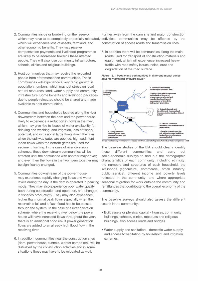
• Locations of affected villages downstream;
• Sensitive community points, such as schools, clinics, community meeting places, mosques and other religious places;
• Emergency services such as hospitals, fire brigade, police stations (nearby but outside of the flood zone, as well as inside);
• Infrastructure such as roads and bridges at risk;
• Local stakeholders in charge of emergency management;
• Communication systems for local communities, existing and in the event of a dam failure.
The Pakistan National Disaster Management Authority (NDMA) has made available guidelines for the preparation of Provincial Disaster Risk Management Plans.37 This can be adapted for developing specific emergency preparedness plans for the hydropower project.
Such a plan should be in place before impoundment, and the relevant stakeholders briefed and trained about their roles and responsibilities in the event of an emergency. The IFC Performance Standard 1 on the Assessment and Management of Environmental and Social Risks and Impacts requires emergency preparedness and training to ensure effective response, and collaboration with potentially affected communities.
18. Socio-economic issues
18.1 Identifying project affected communities and persons
Hydropower projects affect people and communities in different ways according to where they live in relation to the project. Figure 18.1 illustrates the different groups of affected communities, which include:
1. Affected communities bordering on the upstream river above the reservoir, which may be affected by the reduction in fish in the river, and who may be important for the management of the catchment or watershed, e.g. for prevention of erosion. These communities may also be cut off by the reservoir from access to main roads, and so alternative provision may have to be made to replace lost access.
93
EIA Guidelines for large-scale hydropower in Pakistan
2. Communities inside or bordering on the reservoir, which may have to be completely or partially relocated, which will experience loss of assets, farmland, and other economic benefits. They may receive compensation payments and livelihood programmes are likely to be addressed towards these affected people. They will also lose community infrastructure, schools, clinics and religious buildings.
3. Host communities that may receive the relocated people from aforementioned communities. These communities will experience a very rapid growth in population numbers, which may put stress on local natural resources, land, water supply and community infrastructure. Some benefits and livelihood packages due to people relocated should be shared and made available to host communities.
4. Communities and households located along the river downstream between the dam and the power house, likely to experience a reduction in flows in the river, which may give rise to issues of water availability for drinking and washing, and irrigation, loss of fishery potential, and occasional large flows down the river when the spillway gates are opened, high sediment laden flows when the bottom gates are used for sediment flushing. In the case of river diversion schemes, these downstream communities will be affected until the confluence with another major river; and even then the flows in the two rivers together may be significantly changed.
5. Communities downstream of the power house may experience rapidly changing flows and water levels during the day, if the dam is operated in peaking mode. They may also experience poor water quality both during construction and operation, and changes in fisheries productivity. They may also experience higher than normal peak flows especially when the reservoir is full and a flash flood has to be passed through the system. In the case of a river diversion scheme, where the receiving river below the power house will have increased flows throughout the year, there is an additional flood risk if power generation flows are added to an already high flood flow in the receiving river.
6. In addition, communities near the construction sites (dam, power house, tunnels, worker camps etc.) will be disturbed by the construction activities and in some situations these may have to be relocated as well.
Further away from the dam site and major construction activities, communities may be affected by the construction of access roads and transmission lines.
7. In addition there will be communities along the main roads used for transport of construction materials and equipment, which will experience increased heavy traffic with road safety issues, noise, dust and degradation of the road surface.
The baseline studies of the EIA should clearly identify these different communities and carry out socio-economic surveys to find out the demographic characteristics of each community, including ethnicity, the numbers and structures of each household, the livelihoods (agricultural, commercial, small industry, public service), different income and poverty levels reflected in the community, and where appropriate seasonal migration for work outside the community and remittances that contribute to the overall economy of the community.
The baseline surveys should also assess the different assets in the community:
• Built assets or physical capital - houses, community buildings, schools, clinics, mosques and religious buildings, also access roads and bridges.
• Water supply and sanitation – domestic water supply and access to sanitation by household, and irrigation schemes.
Figure 18.1: People and communities in different impact zonesadversely affected by hydropower
38Oxfam Australia (2013)39FPIC was one of the main areas of contention in the World Commission on Dams
Further away from the dam site and major construction activities, communities may be affected by the construction of access roads and transmission lines.
7. In addition there will be communities along the main roads used for transport of construction materials and equipment, which will experience increased heavy traffic with road safety issues, noise, dust and degradation of the road surface.
The baseline studies of the EIA should clearly identify these different communities and carry out socio-economic surveys to find out the demographic characteristics of each community, including ethnicity, the numbers and structures of each household, the livelihoods (agricultural, commercial, small industry, public service), different income and poverty levels reflected in the community, and where appropriate seasonal migration for work outside the community and remittances that contribute to the overall economy of the community.
The baseline surveys should also assess the different assets in the community:
• Built assets or physical capital - houses, community buildings, schools, clinics, mosques and religious buildings, also access roads and bridges.
• Water supply and sanitation – domestic water supply and access to sanitation by household, and irrigation schemes.
94
EIA Guidelines for large-scale hydropower in Pakistan
• Land assets or natural capital – agricultural fields (irrigated and rainfed), including seasonal cropping patterns and yields, forests (community managed and production forests), timber and fruit trees.
• Livestock and animal husbandry – numbers and different types of animals – (cattle, buffalos, sheep and goats, pigs and poultry).
• Fisheries and aquaculture resources – types of fishing, boats and equipment used – seasonal patterns of production and yields.
• Other patterns of natural resource use, e.g. gold panning in the river, eco-tourism, sustainable hunting etc.
• Social and institutional capital in terms of governance and legal structures within the villages, health and educational capacity (teachers, nurses, doctors etc.). Patterns of land ownership, tenure and use, and other assets should also be described. Any government or public institutions that may be present.
The baseline studies are important for determining what will be lost, levels of compensation and for developing appropriate packages for resettlement and livelihood development. In the EIA stage a full enumeration of all the assets may not be required, but this will become necessary for developing the Resettlement Action Plan (RAP).
18.1.1 Vulnerable groups – poor households, women and children
Any large development of this nature tends to have disproportionate impacts on the poor, women, children and other vulnerable groups. Poor people are more dependent upon natural resources that may be lost, and more vulnerable to changes in their livelihoods. Women and children are more vulnerable than men to impacts on food, water availability, and health issues.
The baseline survey should describe the demographic makeup of the communities – proportions of men and women, age structure, proportions of different ethnic groups. The poverty status of the communities and households within the community should be described, including both income per capita and household and other measures of poverty as appropriate – e.g. seasonal food deficit, nutritional status, available income for clothing, health and education etc.
The EIA should identify aspects of vulnerability of these different groups to the impacts of the hydropower project and prepare Vulnerable Groups Development Plan to address these areas of vulnerability identified.
The Oxfam publication “Using Gender Impact Assessment in Hydropower Development”38 identifies common issues arising from hydropower developments that will be experienced differently by women and men:
• Forced or involuntary resettlement• Loss of assets – such as homes, houses, fruit trees, gardens, food stores, community buildings• Loss of land and productive resources• Changes to water quality• Pollution or air, noise, water and soil• Loss of fisheries• Health issues• Risk of sexual exploitation and violence• Loss of cultural lands sites and connection to place
Consideration should be given to how the hydropower project will interact and impact gender and power relations within the community, gender roles and responsibilities, division of labor and workload of women; women’s access and control over resources; community management structures and processes; community well-being, livelihoods and services such as education and health.
18.1.2 Vulnerable groups – ethnic minorities and indigenous peoples
The EIA baseline studies should identify and describe the presence of particularly vulnerable groups. The IFC Performance Standard 7 recognizes Indigenous Peoples as social groups with identities that are distinct from mainstream groups in national societies and that they are often the most marginalized and vulnerable segments of the population. One of the key requirements of this Performance Standard is “FPIC” or Free, Prior and Informed Consent39 which builds on the requirement for Informed Consultation and Participation (ICP) which is an important component of Performance Standard 1. The developer should undertake an engagement process with the Affected Communities of Indigenous Peoples, including stakeholder analysis and engagement planning, disclosure of information, consultation, and participation, in a culturally appropriate manner. In addition, this process will:
95
EIA Guidelines for large-scale hydropower in Pakistan
• Involve Indigenous Peoples’ representative bodies and organizations (e.g., councils of elders or village councils), as well as members of the Affected Communities of Indigenous Peoples; and
• Provide sufficient time for Indigenous Peoples’ decision-making processes.
Box 23: IFC requirements for Free, Prior Informed ConsentFIPIC will be established through good faith negotiation between the developer and the Affected Communities of Indigenous Peoples. Documentation of this negotiation process should show: (i) the mutually accepted process between the client and Affected Communities of Indigenous Peoples, and (ii) evidence of agreement between the parties as the outcome of the negotiations. FPIC does not necessarily require unanimity and may be achieved even when individuals or groups within the community explicitly disagree.
If adverse impacts on Indigenous Peoples, can be expected, the project should take the following steps:
• Document efforts to avoid and otherwise minimize the area of land proposed for the project;
• Document efforts to avoid and otherwise minimize impacts on natural resources and natural areas of importance to Indigenous People;
• Identify and review all property interests and traditional resource uses prior to purchasing or leasing land;
• Assess and document the Affected Communities of Indigenous Peoples’ resource use without prejudicing any Indigenous Peoples’ land claim. The assessment of land and natural resource use should be gender inclusive and specifically consider women’s role in the management and use of these resources;
• Ensure that Affected Communities of Indigenous Peoples are informed of their land rights under national law, including any national law recognizing customary use rights; and
• Offer Affected Communities of Indigenous Peoples compensation and due process in the case of commercial development of their land and natural resources, together with culturally appropriate sustainable development opportunities, including:
- Providing land-based compensation or compensation-in-kind in lieu of cash compensation where feasible.
- Ensuring continued access to natural resources, identifying the equivalent replacement resources, or, as a last option, providing compensation and identifying alternative livelihoods if project development results in the loss of access to and the loss of natural resources independent of project land acquisition.
- Ensuring fair and equitable sharing of benefits associated with project usage of the resources where the client intends to utilize natural resources that are central to the identity and livelihood of Affected Communities of Indigenous People and their usage thereof exacerbates livelihood risk.
- Providing Affected Communities of Indigenous Peoples with access, usage, and transit on land it is developing subject to overriding health, safety, and security considerations.
Source: IFC Performance Standards
18.2 Construction impacts
18.2.1 Physical disturbance – dust, noise, vibration
Communities adjacent to construction sites will experience significant physical disturbance from the noise and vibration, and dust from the construction activities. Blasting in quarries and at the dam site will cause extreme disturbance, especially if carried out frequently and without adequate warning. The dust and vibration from construction traffic along access roads becomes both a significant disturbance and a health hazard.
The EIA should identify those communities most likely to be disturbed through construction activities and propose mitigation measures to reduce the impacts. In the extreme disturbances, it may be necessary to relocate households and communities most at risk from construction activities. Other measures will include notified timings for blasting with adequate prior warnings; traffic calming measures to slow down construction traffic and diversions of access roads around villages; regular application of water from bowsers to settle the dust.
96
EIA Guidelines for large-scale hydropower in Pakistan
18.2.2 Traffic and road safety
Hydropower dams are often located in isolated areas and require the transport of construction materials and equipment to be transported from suppliers in urban areas or ports to the site. Whilst special access roads may have to be built, existing public roads will be used for the transport of materials such as cement, reinforcing steel, cables and major items of equipment such as the turbines and spillway gates. Usually rock, sand and gravel etc. will be sourced locally. The transport of bulk materials and equipment has implications for:
• Wear and tear on roads and bridges• Increased traffic and road usage with congestion, delays and inconvenience for other road users• Road safety and accidents • Health aspects from dust and emissions
The feasibility study should include a logistics analysis, and if the distances for transport of materials and equipment are long and the existing roads are in poor condition, and the increased traffic expected to be significant, then a separate study on the traffic impacts of the proposed project should be undertaken. The EIA should summarize this traffic impact study, identifying particularly villages and towns at risk located on transportation routes for construction materials, and providing specific mitigation measures to minimize the risks.
18.2.3 Loss of infrastructure
The construction of the dam and reservoir may lead to inundation or loss of infrastructure. These may include:
• Roads and bridges – sections of roads may be inundated by the reservoir, and these will have to be replaced at an elevation above the reservoir full supply level. Bridges at the top end of the reservoir may have to be replaced because the water level may be too high. Some communities may also become isolated on one side of the reservoir with access to the other side, only possible by boat. An alternative access road to these communities may have to be provided. The EIA should identify such stretches of road and bridges that will have to be replaced or alternatives provided, and this should be included in the environmental and social management plan budget.
• Public buildings and utilities – The EIA should identify any public buildings, such as schools, clinics, community meeting places and religious buildings that will be inundated or otherwise destroyed. Electricity and communication lines, water treatment facilities etc. should also be enumerated. The replacements should be provided in the resettlement villages to an equivalent or better standard.
• Agriculture, aquaculture and irrigation facilities – infrastructure for agriculture, fish ponds and hatcheries and irrigation schemes that will be inundated should be described in the EIA. Appropriate replacements should be agreed with the communities and owners in the resettlement villages, or financial compensation provided.
• Business and industry – infrastructure associated with small businesses and local industries that will be inundated should be enumerated and described in the EIA. Replacements or compensation agreed with the owners.
18.2.4 Operational changes in hydrology
During operation, are there likely to be sudden changes in flow releases from the dam that may be dangerous for river users. For example, during peak load operation when there may be sudden increases in flow (within minutes) when the turbines are opened up, and water levels rise rapidly (up to 1 -2 m within 30 minutes). Such changes in flow can surprise people using the river for tens of kilometers downstream, especially fishermen, livestock, people bathing and washing.
The EIA should describe peaking operations and the expected rate of changes in flow and water level at different points downstream (e.g. immediately downstream of the power house, after 1 km, 5 km and 10 km). If these are considered to be hazardous, the ramping rate bringing the turbines up to full design flow may be modified.
In addition, the awareness of communities downstream should be raised about these changes and what time of day they are likely to occur. Warning signals should be agreed, and in the event of unusual changes in flow, e.g. when the spillway gates are opened, the communities downstream should be notified several days beforehand.
97
EIA Guidelines for large-scale hydropower in Pakistan
18.2.5 Loss of safe drinking water sources
Construction activities generally result in reduction of surface water quality, especially increasing the suspended solids, but also the possibility of contamination with oils and construction materials. If communities are reliant upon the river for supply of drinking water, or water for washing, watering their animals and for irrigation, then alternative provision may have to be made for water supply for these uses.
During operation there is also likely to be changes in water quality, especially at the beginning when the vegetation in the reservoir area is broken down with poor quality, anoxic water being released downstream. This will have impacts upon users of the river water. The EIA should include a study of water requirements and uses in downstream communities for an appropriate distance downstream. This may range from 10 km to > 50 km downstream depending upon the context and configuration of the river valley. The changes in water quality and the populations likely to be affected should be estimated.
The mitigation measures often include the provision of water supplies, e.g. groundwater from tube wells, and the building of public water use areas for washing and watering livestock in those communities identified as being at risk from reduced water quality in either construction or operation.
Assessments of ground water quantity and quality should be carried out to ensure the adequacy of supply. This should be included in the Downstream Community Development Plan.
18.2.6 Health and safety issues during construction
Community health, safety and security are covered under the IFC Performance Standard 4. This standard aims to anticipate and avoid adverse impacts on the health and safety of affected communities during the project life from both routine and non-routine circumstances, and to ensure that the safeguarding of personnel and property is carried out in accordance with relevant human rights principles and in a manner that avoids or minimizes the risks to the affected communities.
There are a number of occupational health and safety risks to workers, some of whom may also come from nearby communities.
Construction work exposes workers to a variety of health and safety risks, e.g. physical dangers of construction work, unprotected use of chemicals etc. This should be covered in the Health, Safety and Environment (HSE policy) of the hydropower development company and the contractors. The health impact assessment section of the EIA should describe this policy. Where possible it should identify any hazardous chemicals that may be used and the provision of PPE (Personal Protective Equipment). Onsite first-aid facilities should be provided. Emergency procedures should be established and staff training undertaken.
Community health and safety risks may arise due to the transportation, storage and disposal of materials that are likely to create physical, chemical, biological or radiological hazards. Communities living near construction sites and near transportation routes may also be exposed to these hazards. The EIA should identify the nearby communities at risk from the different hazards and recommend appropriate precautionary measures.
Accidents may also occur if people from local communities (or general public) gain access to dangerous locations within the construction site. The EIA should identify any original pathways through the construction site area used by local communities and in consultation with the local community stakeholders recommend alternative routes and pathways that can be provided. Even with this management of public access to the construction sites, particularly hazardous areas (deep pits, steep cliffs, waste disposal sites etc.) should be fenced and warning signs posted in local languages.
18.2.7 Social pressures
The construction of a large hydropower project usually involves are large workforce of skilled and unskilled labor. In some instances a large dam may have several thousand workers on site at any time, though exact numbers will vary depending upon the construction stage. It is usually impossible for all of these workers to be sourced locally, and so many will come from other parts of the country. In some instances where the developer and/or contractor are foreign, significant numbers of the workforce may also be from different countries. These foreign workers may not speak the same language and will have cultural differences and requirements. Usually the concession agreement may specify the proportion of local or national workers that must be used.
98
EIA Guidelines for large-scale hydropower in Pakistan
There will, thus, be a large temporary population influx of workers, families and camp-followers during construction that increases pressure on infrastructure and services, e.g. water supply and sanitation, food supplies. This puts pressure on the local communities, the infrastructure and facilities, which may not be able to cope. Economic pressures arise from the increase in demand and prices for local food and services. Social pressures may include prostitution and health issues such as sexually transmitted diseases (STDs).
The EIA should describe the numbers of workers to be brought in from outside and identify the location and size of worker camps and colonies. The nearest villages should be identified and their size and location described. These villages should receive specific assistance and advice in their dealings with the worker camps. There may be small business opportunities, e.g. restaurants and mechanic services which can be encouraged.
The worker camps should be established with good facilities for accommodation and recreation. They should have good water supply and adequate waste water treatment and solid waste disposal. If local food sources are not readily available, as is likely in many remote locations, most food will have to be brought in from outside. Worker camps should have clinics and all workers should receive public health awareness and training appropriate to the health risks both to themselves and the local communities. The hydropower company’s policy for managing workers and the social pressures should be stated where this is available. A conflict resolution mechanism should be established with local community leaders to deal with any issues arising between the worker camps and local communities.
Despite the establishment of specific worker camps and colonies, large construction projects which last a few years often lead to the development of informal settlements and shanty towns. Families and camp followers may settle in the area, living in temporary houses without any facilities for water supply or waste disposal. This leads to a degradation of the local environment such as water pollution, solid waste dumping, cutting of trees for firewood, illegal hunting etc.
From the information on numbers of workers and previous experience with similar projects, the EIA may estimate the numbers of families and camp followers that may be expected, and hence the risks and sizes of informal settlements developing. The hydropower
company and their contractors should have a policy for managing such settlements, including the identification of specific areas and provision of facilities such as water supply and waste disposal.
The company should have a commitment to remove, clean up and rehabilitate the areas of both, worker camps and informal settlements after the completion of the construction work, according to the requirements of the local communities, who should be consulted about future use of the area.
18.3 Resettlement and relocation
Resettlement requirements are perhaps the most difficult impacts of large hydropower projects to resolve effectively and to the satisfaction of all affected persons. They are also amongst the most controversial of hydropower impacts, and the record of poorly implemented resettlement projects in the past continues to haunt the hydropower sector and the reputation of hydropower developers. Because hydropower projects are often located in more remote places, the people affected are generally the poorer and more vulnerable sectors of the population.
The socio-economic baseline survey of the communities in the different affected zones will establish the scale of resettlement, and the approximate number of households being displaced, and the areas of agricultural and other land holdings to be lost during construction of the dam and inundation of the reservoir. The baseline survey should also cover a detailed description of the livelihood patterns and poverty status of the communities and the ethnic mix of the population.
The development of the Resettlement Action Plan will require a more detailed census and inventory of all the persons entitled to compensation and resettlement. The inventory should cover the houses, the land, trees and crops and other fixed assets, such as wells and irrigation schemes that will be lost. Community infrastructure should also be recorded. The cut-off date should be clearly announced before the census in order to avoid false claims, and it may be necessary to repeat the census if more than two years have elapsed before land acquisition. The census and inventory should be conducted by social scientists and trained local persons using such tools as structured and semi-structured questionnaires and census and inventory forms, which should be pilot tested before implementation. Female surveyors will be needed for discussions with women in the households.
99
EIA Guidelines for large-scale hydropower in Pakistan
While conducting surveys in tribal areas, their norms and cultures must be respected, and planning of surveys should be done through a political agent and Jirgah to ensure effective implementation.
At the same time, suitable land for resettlement, establishing model villages and existing host villages will have to be identified. This will require social surveyors, land surveyors and agronomists and water engineers to assess the availability and suitability of the land, as well as discussions and agreements with local government agencies. Some of the characteristics of the potential resettlement sites include proximity to affected areas or sites – most people wish to be resettled as near as possible to their original villages, and with the same community of people; smooth topography, avoiding steep and unstable slopes; with good potential for infrastructure development, with soils suitable for irrigation and sufficient water availability. Above all, the host community’s acceptance is required.
Throughout the process of the EIA and development of the RAP, a comprehensive community engagement plan should be established and implemented. This should cover disclosure of information about the project and the need for resettlement, and provide information about the resettlement options and packages being designed. The involvement of the affected communities in developing and deciding upon the details is essential to ensure acceptance of the resettlement, e.g. style and design of houses, provision of utilities such as water and electricity, and facilities for health, education, transport.
The timing of the resettlement plan is critical, because as a principle, no relocation should take place until the resettlement villages have been prepared. It is possible to acquire the land in advance, but allow the PAPs to remain on the land and using it until relocation date. Delays in implementation of resettlement can cause delays in filling of the reservoir and start of power generation. During and immediately after the actual relocation process financial and food assistance may be provided to compensate for the immediate loss of income or livelihoods due to the disruption.
Box 24: Resettlement in the Ghazi-Barotha Hydropower Project
The Ghazi-Barotha Hydropower Project consists of three main components: the barrage at one end on the Indus River below Tarbela Dam; a power complex downstream which would generate power, and the 52 km concrete-lined power channel with a width of about 58.4 meters.
It is the power channel that is the focus of most of the resettlement issues involved in the project. The total project cost was about $2.2 billion USD. In order to build the system, it was necessary to acquire 5000 hectares of land. From the earliest stages of the project there has been the participation of all stakeholders. “Scoping Sessions” occurred in all 54 villages affected by the project in order to discuss the project at large and the necessary steps of land acquisition and the resulting resettlement. Three main NGOs also participated in the project at this stage in order to assist in minimizing the environmental, social and resettlement impacts of the project. An independent Environment and Resettlement Panel consisting of internationally recognized experts was formed at the pre-feasibility stage to assist in overlooking the project as it was being prepared.
Due to the consultations and inputs from all of the stakeholder groups, concerns over the environment, resettlement and the protection of certain sites were considered in detail in the evaluation of design alternatives and led to the adoption of a number of modifications. As a result, the power channel’s original path was changed dramatically. In order to avoid submerging certain sacred sites, cultural heritage sites and graveyards, as well as many homesteads, the channel was moved to higher ground. Instead of the straight path, as originally conceived, the channel’s path meandered. While this added a great deal of cost, about $50 million USD, and required more complicated engineering to the project, this change also reduced the number of people who were to be relocated from 40,000 to 1,000. The greater complexity and cost of the new design was made up in the fact that it was much more socially and environmentally responsible.
Project Information Centers (PICs) were an important component in facilitating the RAP prepared by WAPDA being used both for information dissemination and grievance redressal. The PICs are staffed by a number of sociologists, including women who focus on gender issues. Going into the communities, both increased the knowledge of the project team and allowed for greater participation of local citizens. The PICs have created a database of the grievances to better help the staff address the problems as quickly as possible. The database catalogues the vulnerable communities, gender issues, how information has been disseminated, and project outreach. The centers also serve as a point where contractors can recruit local labor. They assist people in getting work permits and have lists of the skills for those seeking work.

100
EIA Guidelines for large-scale hydropower in Pakistan
In order to facilitate the process of land acquisition, the Ghazi-Barotha Development Organization (GBDO) was specially formed. It is an independent organization, whose Board consists of 13 members, 6 of whom are representatives from the community and half of whom are women. GBDO’s role is to be responsible for the implementation of the integrated regional development plan for the economic and social development of the affected areas. This organization was also tasked with an advocacy role on land acquisition and compensation issues. The RAP recommended the creation of Land Valuation Committees (LVC) in order to try to determine a fair market value for land that would be bought for the project.
The problem which evolved was that as more people became aware of which land was to be bought for the project, land speculation began. Government officials joined in the speculation and the total cost of the land, which was expected to be about 2 billion rupees, skyrocketed to 8 billion rupees. In that instance, the project was halted. The GBDO went into all 54 communities and negotiated with the land holders in order to get around the LVCs. They explained that without reasonable market values for the land, the project would not move forward and the people in the end would get nothing. While a neutral organization, the GBDO became an advocate of the implementing agencies, trying to keep project costs down. Through its actions, the GBDO gained the trust of the people affected, the NGOs and the implementing agencies. The result was that GBDO was able to negotiate the land purchases down to 4.5 billion rupees – still much more than the original estimate, but low enough to keep the project on track.
Source: World Bank case study on Ghazi Barotha
18.4 Loss of livelihoods and livelihood restoration
A hydropower project can destroy or change the livelihoods of project affected persons and whole communities through the loss or inundation of agricultural and forest land and other means of production and income generation. It may also reduce informal sources of food and income by reducing access to forest land for gathering wild vegetables, firewood, fibre and medicinal plants. It may reduce both the access and availability of fish and other aquatic plants and animals which can provide both nutrition and income. For small businesses, the relocation of a community may disrupt and generally reduce the income flow.
For people and communities that are often the poorest, such losses could be disastrous. It is therefore essential that a comprehensive livelihoods restoration plan be developed in parallel with resettlement plans. It is important that such plans be developed not just for the people who are physically displaced, but also for those who are economically displaced, especially those who lose access to their original livelihoods, e.g. people living downstream or in the catchment above the reservoir.
In order to develop a livelihood restoration plan, the socio-economic survey of the EIA should be used. This describes the patterns of livelihood, poverty levels and vulnerabilities of the communities in the different impact zones. As well as the main agricultural, livestock husbandry, fisheries or forestry practices that yield food and income, the other forms of livelihood such as handicrafts, gold panning on the river, tourism and small businesses should be described. An analysis of the current skills sets available to the community should also be described. Estimates of current household income levels may be made and these can be used later as indicators for achievement of the livelihood restoration plan.
The main issue for the people being resettled is the fact that generally the natural resources – soil, water etc. may be very different to those that they have been used to, and then require a radical change in their use and agricultural practices. The more vulnerable sections of the community will have difficulty making these changes, especially if they have low literacy and technical skills.
In addition to any compensation that may be payable, the livelihoods restoration packages should include land clearance and preparation, especially if it has not be used for crops, or irrigated before. Any irrigation schemes should be put in place as part of the resettlement, but training in its application and the development of water user groups may be necessary. The crops themselves or the varieties used may be different, and the farmers too may require training in their use.
The reservoir may be a potentially important fishery. However, the local people are unlikely to have had any experience of lake fishery techniques or equipment. They may require credit facilities for the purchase of boats and equipment and training in the use. Boat landings and fish market facilities may be required at strategic points on the reservoir.
101
EIA Guidelines for large-scale hydropower in Pakistan
Provision should be made for diversification of livelihoods, and for a specific focus on developing different livelihood options for women. Micro-credit facilities should be provided. Some hydropower projects have established vocational training programmes and skills development in mechanics, building and construction techniques and small business management. Training in the tourism sector may also be an option, if the dam and reservoir is seen as a potential tourism attraction. Those trained may also be used or employed during the construction of the dam. Thus employment in the project can be seen as part of the livelihoods restoration package.
Throughout the development and implementation of the livelihoods restoration plan, consultation with the affected communities to understand their wishes and needs is essential. Small focus group discussions on the detailed requirements may be more effective than large community meetings.
The livelihoods restoration plan should be continuously monitored against the achievement of the development targets and indicators selected. A great deal of care must be exercised when fixing these targets and indicators; household income is but one of a number of potential indicators.
18.4.1 Tourism and recreation
Hydropower development can have both significant adverse impacts and opportunities for tourism and recreation. On the one hand, the construction activities and inundation can destroy natural features in the river, such as waterfalls and rapids that may be important locations for tourism and recreation, picnic and swimming sites and viewpoints. The river itself may have become part of an adventure tourism resource, with boating, kayaking and white water rafting, or an important sport fishery. These may be lost or changed due to the construction or inundation. Some cultural or heritage tourism sites may also be inundated.
On the other hand, the creation of a large and impressive dam often leads to the development of visitor facilities and recreational sites associated with the dam. The reservoir may also provide opportunities for boating, water sports, picnic areas etc.
18.4.2 Employment opportunities
The development of a hydropower project will provide opportunities for employment for the local communities, unskilled, semi-skilled and skilled. During the construction phase, large numbers (several thousand) of job opportunities will be available, but far fewer (under one hundred) during the operational phase. It is generally expected that preference will be given to local applicants where possible.
In addition there will be a number of business opportunities created for service industries, e.g. building construction, repair and mechanics shops.
The EIA should estimate the number of job opportunities during the different phases of construction and operation, and estimate the proportion that will be available for local communities. It should recommend procedures for local hire and for dealing with labour complaints. Skill training and small business development facilities should also be provided to prepare local communities to take advantage of such opportunities.
18.5 Establishing a Grievance Redress Mechanism
Before the start of construction a Grievance Redress Mechanism (GRM) should be established. The purpose of this is to provide a clear, transparent and easy to use process for affected communities, households and individuals to complain or draw the attention of the developer to particular issues. This needs to be agreed through a consultation process with affected communities. The important features of such a GRM are that:
• It should be easily accessible – there is no point in having such a mechanism which is in the project offices in the town which may be 50 km away from the affected community;
• It should be equally accessible by women and men;
• Complaints should be addressed regularly by a representative local resettlement council that includes developer, contractor, affected community leaders and local government;
102
EIA Guidelines for large-scale hydropower in Pakistan
• The complainant should be informed of findings of the committee immediately afterwards;
• If the complainant is still not satisfied with the decision of local committee, the complaint may be taken to provincial or federal level resettlement councils or to a court of law;
• A publicly available record of all complaints received with findings should be kept in the project offices.
19. Benefit sharing
One of the key statements of the World Commission on Dams was that ‘too often water infrastructure projects have been developed at an unacceptable environmental or social cost’ including failure to deliver expected benefits; delays and cost over-runs; loss of forests and biodiversity, failure of mitigation measures, cumulative impacts; population displacement, livelihoods adversely affected, lack of compensation, inequitable distribution of benefits.
Benefit sharing aims to distribute the benefits of hydropower equitably to river basin residents and across the economy. It stems from the principle that people who are affected by hydropower should be amongst the first to receive benefits form the project, not the last. Benefit sharing mechanisms provide the means that ensure local communities can benefit from hydropower development.
There is a need to distinguish between benefit sharing and compensation and mitigation costs. Compensation, whether in the form of monetary value or replacement in-kind, is due to all affected persons who have suffered losses to their houses, assets and sources of income and livelihoods. Mitigation costs are due to protect the environment by reducing the impact or rehabilitating the assets after the project has been completed. Benefit sharing recognizes that the previous natural resources of an area (the water flow and hydropower potential) have been “captured” for economic benefit and that the people living in the area have a right to share in that benefit.
A useful collection of information about benefit sharing is the Mekong River Commission’s Knowledge Base on Benefit sharing.40 There are several different approaches to share benefits with project affected communities and residents of river basins where hydropower projects are located.
• Transboundary benefit sharing is a wider consideration of equitable utilization and sharing of benefits (and costs) of water resource development and use, involving two or more countries on international water courses. It is based on IWRM principles, negotiation and agreements among national and sub-national levels in a country.
• National-to-local forms involve sharing benefits of hydropower among national and sub-national levels within the country. Certain benefits may be shared with river basin residents at provincial, district, municipal and local levels, or a combination of these.
If there is not a dedicated approach to benefit sharing, then there is a risk that affected communities may be worse off as a result of hydropower development. National policy, laws and regulations are needed to ensure that affected communities receive benefits. Budget allocation of hydropower revenue should be directed to provide services and benefits to affected communities at local level (e.g. health and education). Responsible hydropower companies will include local benefits as part of their projects. Monitoring and an accountable system for benefit distribution at the local level is essential. Figure 19.1 shows a schematic of the money flows from a hydropower project, showing differentiating between compensation and mitigation and how benefits can be shared from the taxes and revenues paid by the project to government.
Benefits may be shared in both monetary and non-monetary forms. Monetary forms may be derived from taxes and revenues, or contributions to, long-term regional development fund, an environmental fund or to a community development fund. It may take the form of additional long-term compensation for project-affected populations, or some form of partnership between the developers and the local communities. Another monetary mechanism would grant an equity share of the project to local communities, who would thus have a degree of ownership in the project and receive dividends on the profit. Also communities may benefit from preferential low rates of the electricity they consume.
40Noted MRC Initiative on Sustainable Hydropower (2013) Knowledge base on Benefit Sharing - Volume 1 summary and guide to the Knowledge base Compendium. http://www.mrcmekong.org/assets/Publications/Manuals-and-Tool-kits/knowledge-base-benefit-sharing-vol1-of-5-Jan-2012.pdf
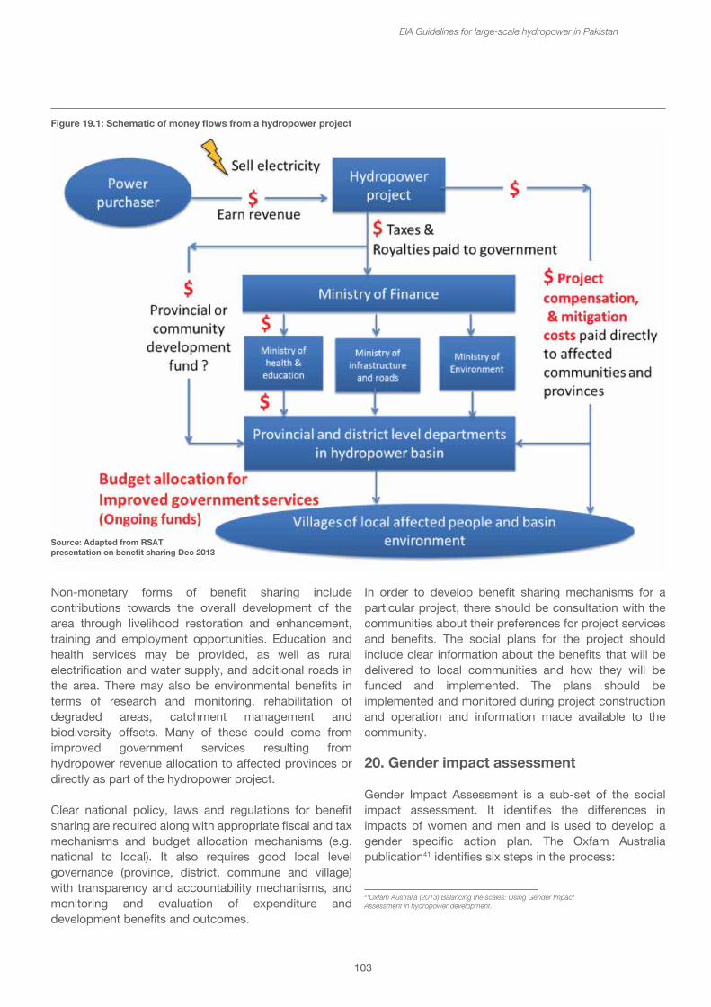
• Transboundary benefit sharing is a wider consideration of equitable utilization and sharing of benefits (and costs) of water resource development and use, involving two or more countries on international water courses. It is based on IWRM principles, negotiation and agreements among national and sub-national levels in a country.
• National-to-local forms involve sharing benefits of hydropower among national and sub-national levels within the country. Certain benefits may be shared with river basin residents at provincial, district, municipal and local levels, or a combination of these.
If there is not a dedicated approach to benefit sharing, then there is a risk that affected communities may be worse off as a result of hydropower development. National policy, laws and regulations are needed to ensure that affected communities receive benefits. Budget allocation of hydropower revenue should be directed to provide services and benefits to affected communities at local level (e.g. health and education). Responsible hydropower companies will include local benefits as part of their projects. Monitoring and an accountable system for benefit distribution at the local level is essential. Figure 19.1 shows a schematic of the money flows from a hydropower project, showing differentiating between compensation and mitigation and how benefits can be shared from the taxes and revenues paid by the project to government.
Benefits may be shared in both monetary and non-monetary forms. Monetary forms may be derived from taxes and revenues, or contributions to, long-term regional development fund, an environmental fund or to a community development fund. It may take the form of additional long-term compensation for project-affected populations, or some form of partnership between the developers and the local communities. Another monetary mechanism would grant an equity share of the project to local communities, who would thus have a degree of ownership in the project and receive dividends on the profit. Also communities may benefit from preferential low rates of the electricity they consume.
103
EIA Guidelines for large-scale hydropower in Pakistan
In order to develop benefit sharing mechanisms for a particular project, there should be consultation with the communities about their preferences for project services and benefits. The social plans for the project should include clear information about the benefits that will be delivered to local communities and how they will be funded and implemented. The plans should be implemented and monitored during project construction and operation and information made available to the community.
20. Gender impact assessment
Gender Impact Assessment is a sub-set of the social impact assessment. It identifies the differences in impacts of women and men and is used to develop a gender specific action plan. The Oxfam Australia publication41 identifies six steps in the process:
Non-monetary forms of benefit sharing include contributions towards the overall development of the area through livelihood restoration and enhancement, training and employment opportunities. Education and health services may be provided, as well as rural electrification and water supply, and additional roads in the area. There may also be environmental benefits in terms of research and monitoring, rehabilitation of degraded areas, catchment management and biodiversity offsets. Many of these could come from improved government services resulting from hydropower revenue allocation to affected provinces or directly as part of the hydropower project.
Clear national policy, laws and regulations for benefit sharing are required along with appropriate fiscal and tax mechanisms and budget allocation mechanisms (e.g. national to local). It also requires good local level governance (province, district, commune and village) with transparency and accountability mechanisms, and monitoring and evaluation of expenditure and development benefits and outcomes.
Source: Adapted from RSATpresentation on benefit sharing Dec 2013
Figure 19.1: Schematic of money flows from a hydropower project
41Oxfam Australia (2013) Balancing the scales: Using Gender ImpactAssessment in hydropower development.
104
EIA Guidelines for large-scale hydropower in Pakistan
rates and morbidity of the population. Mother and child health statistics are an important indicator. The baseline would also review the provision of health services, clinics, hospitals, doctors and nurses. The baselines studies should consider health status of populations in the different impact zones, because the impacts are likely to be different.
The second step in the process would be to identify the main health stresses and diseases that are likely to arise in the course of a hydropower project, and to assess their potential impacts upon the affected communities. These health stresses will be different depending upon the phase of the project as well as impact zone. The potential health stresses associated with a hydropower project include:
• Construction activities causing noise and disturbance to nearby communities;
• Atmospheric dust along roads and near construction sites and quarries aggravating respiratory disorders;
• Contamination of drinking water supplies, e.g. from untreated waste waters from worker camps and solid waste dumping, and from high suspended solids content;
• Accidents from traffic and construction activities;
• Emotional and psychological stress during resettlement to new locations;
• Nutritional disorders due to loss of access to sources of protein and nutrients, e.g. fish and wild foods and due to disruption and changes in agricultural and other livelihood practices;
• Transmitted diseases from contact with large external workforce, including STDs and HIV/AIDS.
The mitigation and management of these health stresses require the development of specific measures both to reduce the risks, to deal with and cure any disorders. Mitigation of pollution-related disorders can be addressed through reducing the sources of the pollution; management of accident risk can be achieved through control of access to hazardous locations and for workers, the provision of safety equipment and training; and the risks of transmitted diseases through health training and awareness, and worker regulations.
1. Gathering the data – establishing a project specific baseline that analyses gender – this stresses the importance of having gender disaggregated baseline data about the communities.
2. Understanding the context – this includes a series of checklist questions that highlight the gender differences. These checklist questions can be downloaded from the Oxfam website.42
3. Identify the issues introduced by the dam, focused in the different impact zones. 4. Understanding women’s and men’s needs and aspirations, considering what women need to help them in their roles and responsibilities and what structural and institutional changes are required to achieve greater equality in the community. This concerns the ways in which hydropower has the potential to play a transformative role in gender relations and women’s equality.
5. Gender Strategy and Action Plan for gender risk awareness and compliance.
6. Review, Audit and Respond.
Whilst the IFC Performance Standards include gender analysis as an essential cross-cutting component of the social impact assessment in many of the performance standards, especially No. 1, 4, 5 and 7, there is not a specific obligation to carry out a Gender Impact Assessment and Action Plan.
21. Health impact assessments
IFC Performance Standard 7 covers Community Health, Safety and Security. It aims to anticipate and avoid adverse impacts on the health and safety of the Affected Communities, during the project life from both routine and non-routine circumstances. It provides for the developer to evaluate the risks and impacts to the health of the communities and establish preventative and control measures consistent with good international industry practice, such as in the World Bank Group Environmental, Health and Safety Guidelines. Safety issues are also included in this Performance Standard.
A Health Impact Assessment can be a stand-alone assessment or included as part of the overall EIA. It should follow the basic impact assessment process of first establishing the baseline health status of the communities, the prevalence of diseases, and mortality42www.oxfam.org.au/giamanual
rates and morbidity of the population. Mother and child health statistics are an important indicator. The baseline would also review the provision of health services, clinics, hospitals, doctors and nurses. The baselines studies should consider health status of populations in the different impact zones, because the impacts are likely to be different.
The second step in the process would be to identify the main health stresses and diseases that are likely to arise in the course of a hydropower project, and to assess their potential impacts upon the affected communities. These health stresses will be different depending upon the phase of the project as well as impact zone. The potential health stresses associated with a hydropower project include:
• Construction activities causing noise and disturbance to nearby communities;
• Atmospheric dust along roads and near construction sites and quarries aggravating respiratory disorders;
• Contamination of drinking water supplies, e.g. from untreated waste waters from worker camps and solid waste dumping, and from high suspended solids content;
• Accidents from traffic and construction activities;
• Emotional and psychological stress during resettlement to new locations;
• Nutritional disorders due to loss of access to sources of protein and nutrients, e.g. fish and wild foods and due to disruption and changes in agricultural and other livelihood practices;
• Transmitted diseases from contact with large external workforce, including STDs and HIV/AIDS.
The mitigation and management of these health stresses require the development of specific measures both to reduce the risks, to deal with and cure any disorders. Mitigation of pollution-related disorders can be addressed through reducing the sources of the pollution; management of accident risk can be achieved through control of access to hazardous locations and for workers, the provision of safety equipment and training; and the risks of transmitted diseases through health training and awareness, and worker regulations.
105
EIA Guidelines for large-scale hydropower in Pakistan
One provision that should be made in the contractor’s EMP is that if any “chance finds” of archeological or palaeological interest are uncovered during the course of construction, then construction activities should be immediately stopped in that location pending further investigation.
Living cultural impact assessment is especially important where there are indigenous and ethnic minorities and more isolated communities, because a hydropower development has the potential to change the traditional culture of the communities completely. There may be special ceremonies that different communities may need to perform before leaving the areas where they have been living and again when they are relocated to their new host villages. These may be associated with graves of ancestors and holy saints and other sacred places, or they be associated with the overall sense of place of these communities. Some peoples are happy for graves to be left to be inundated, others require the graves to be moved and relocated with the community. Such assessment and management measures require sensitive discussions with the affected communities, usually by a social anthropologist. Some mitigation measures may include the establishment of a museum of the cultural heritage which can be managed and organized by the local communities themselves, so that they can have a record for the future.
Box 25: Archaeological impact assessment of the Diamer Bhasha Dam on the Chilas rock carvings
As part of the EIA of the Diamer Bhasha Dam, an archaeological assessment was carried out on the impact of the dam on the rock carvings around Chilas. These rock carvings, which date from the last four to five thousand years, are found in a number of locations around northern Pakistan including Hunza, Skardu and Gilgit. They are principally the rock carvings in the project area that depict scenes from the life of previous non-Muslim eras, such as Brahaminical and Buddhistic periods and are generally neither understood nor respected by local people. In some areas like Chilas, rock carvings are widespread covering rock outcrops, cliffs overlooking the Indus River, and many boulders. Worldwide relevance is due to the fact that it is one of the rare locations where over 32,000 rock carvings are found. The culture of previous 5000 years is illustrated by the rock carvings. These carvings and inscriptions depict the life of previous ethnics in the northern Pakistan region. They are also an important tourist attraction, especially in the Chilas area where the carvings are easily accessible.
Nutritional disorders would require a combination of provision of appropriate foodstuffs and supplements during the disruption period, awareness raising and training.
Appropriately staffed clinics for workers should be provided at the worker camps, and for affected communities and host communities both before and during the resettlement process. Permanent facilities should be provided as part of the overall community development packages.
22. Archaeological and Cultural Impact Assessment
Archaeological and cultural impact assessments are another specialized sub-set of the EIA. A Cultural heritage impact assessment is the process used to integrate cultural heritage management with the impact of planning proposals. Impact assessments are an established process for ensuring that proponents of the project assume primary responsibility for protection of cultural and heritage values that may be affected by the hydropower scheme. The assessment would ensure that relevant heritage management and monitoring is undertaken. By incorporating community and stakeholder views in the assessment, the decision-making processes can be assured of whether a proposal adequately safeguards cultural heritage. In the case of high value sites, the hierarchy of mitigation measures – avoid, reduce, rehabilitate or compensate – should be applied. Avoidance might lead to changes in the design of the scheme.
An archaeological and cultural heritage impact assessment involves scoping out the assets in the different impact zones, through desk study review of earlier work on the archaeological and cultural heritage in these zones. This will indicate the need for specialist field surveys to document and describe the archaeological, palaeological and cultural heritage sites, buildings and artifacts at risk within these areas. The assessment should provide for mitigation and management measures to document and record for future study and otherwise protect and conserve the different sites and artifacts. Items of high value that may be inundated by the reservoir or destroyed by the construction activities may be removed and relocated. The process should identify any opportunities for research, excavation and scientific recording that may be essential for important sites that will be lost, because this represents the last chance for developing an understanding of the history and cultures associated with the sites.
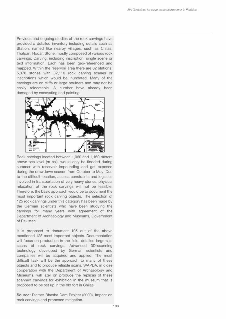
106
EIA Guidelines for large-scale hydropower in Pakistan
Previous and ongoing studies of the rock carvings have provided a detailed inventory including details such as Station: named like nearby villages, such as Chilas, Thalpan, Hodar; Stone: mostly composed of various rock carvings; Carving, including inscription: single scene or text information. Each has been geo-referenced and mapped. Within the reservoir area there are 82 stations; 5,370 stones with 32,110 rock carving scenes or inscriptions which would be inundated. Many of the carvings are on cliffs or large boulders and may not be easily relocatable. A number have already been damaged by excavating and painting.
Rock carvings located between 1,060 and 1,160 meters above sea level (m asl), would only be flooded during summer with reservoir impounding and get exposed during the drawdown season from October to May. Due to the difficult location, access constraints and logistics involved in transportation of very heavy stones, physical relocation of the rock carvings will not be feasible. Therefore, the basic approach would be to document the most important rock carving objects. The selection of 125 rock carvings under this category has been made by the German scientists who have been studying the carvings for many years with agreement of the Department of Archaeology and Museums, Government of Pakistan.
It is proposed to document 105 out of the above mentioned 125 most important objects. Documentation will focus on production in the field, detailed large-size scans of rock carvings. Advanced 3D-scanning technology developed by German scientists and companies will be acquired and applied. The most difficult task will be the approach to many of these objects and to produce reliable scans. WAPDA, in close cooperation with the Department of Archaeology and Museums, will later on produce the replicas of these scanned carvings for exhibition in the museum that is proposed to be set up in the old fort in Chilas.
Source: Diamer Bhasha Dam Project (2009), Impact on rock carvings and proposed mitigation.
107
EIA Guidelines for large-scale hydropower in Pakistan
Annex 1 – About the National Impact Assessment Programme
The Government of Pakistan (GoP) and International Union for Conservation of Nature (IUCN) are jointly implementing the National Impact Assessment Programme (NIAP) that aims to contribute to sustainable development in Pakistan through strengthening the Environmental Impact Assessment (EIA) process and introducing Strategic Environmental Assessment (SEA) in national development planning. The Programme has four implementation partners: Pakistan Environmental Protection Agency (Pak EPA) and Environment Wing (EW) of the Climate Change Division (CCD), Planning Commission of Pakistan (PC), and IUCN Pakistan. Additionally, the Netherlands Commission for Environmental Assessment (NCEA) has an advisory role in the Project and provides technical advice. The total duration of the Programme is four and a half years.
As part of its strategy to carry out capacity building, develop tools and procedures, NIAP recognizes the unavailability of quality sectoral guidelines as one of the major constraints faced by the EPAs in adequately reviewing EIAs of large projects. Little attention has been paid towards the development of guidelines in emerging sectors that have national and international significance. NIAP plans to develop guidelines for three sectors of national and strategic significance to assist its partner EPAs. The three sectors scoped initially as part of this strategy are transboundary natural gas pipelines, large hydro dams and coal-fired thermal power plants. The last major sectoral guidelines for thermal plants were developed in 1997 (GoP, 1997). The lack of sectoral guidelines has far-reaching implications, e.g. the US$900 million thermal power plant which was sanctioned in February 2013 was initially not approved by the ADB because of the adverse and unaccounted environmental impacts associated with the use of Thar Coal (Express Tribune, 2013). Although international best practice on EIAs for thermal power plants do exist, e.g. the USAID EIA Technical Review Guidelines, there is no set of guidelines available for Pakistan. Once developed, these guidelines will provide the much needed support to provincial EPAs, financial institutions and civil society in addressing environmental and social concerns associated with such thermal plants.
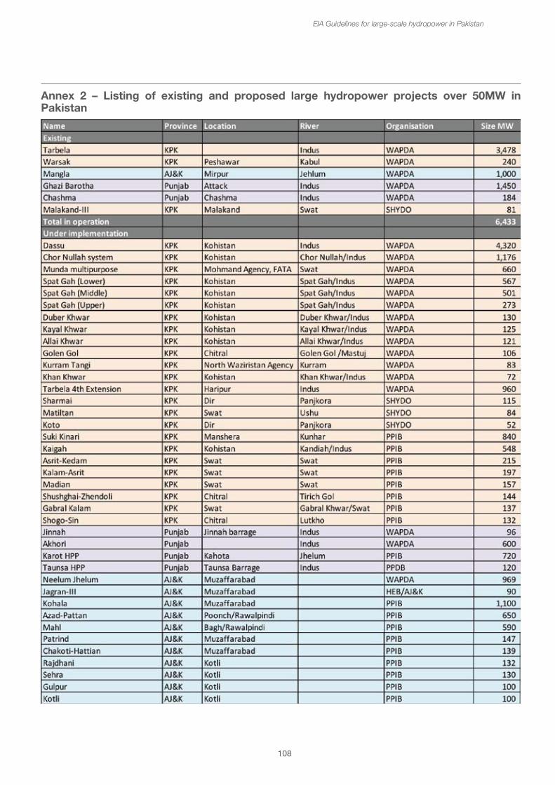
108
EIA Guidelines for large-scale hydropower in Pakistan
Annex 2 – Listing of existing and proposed large hydropower projects over 50MW in Pakistan
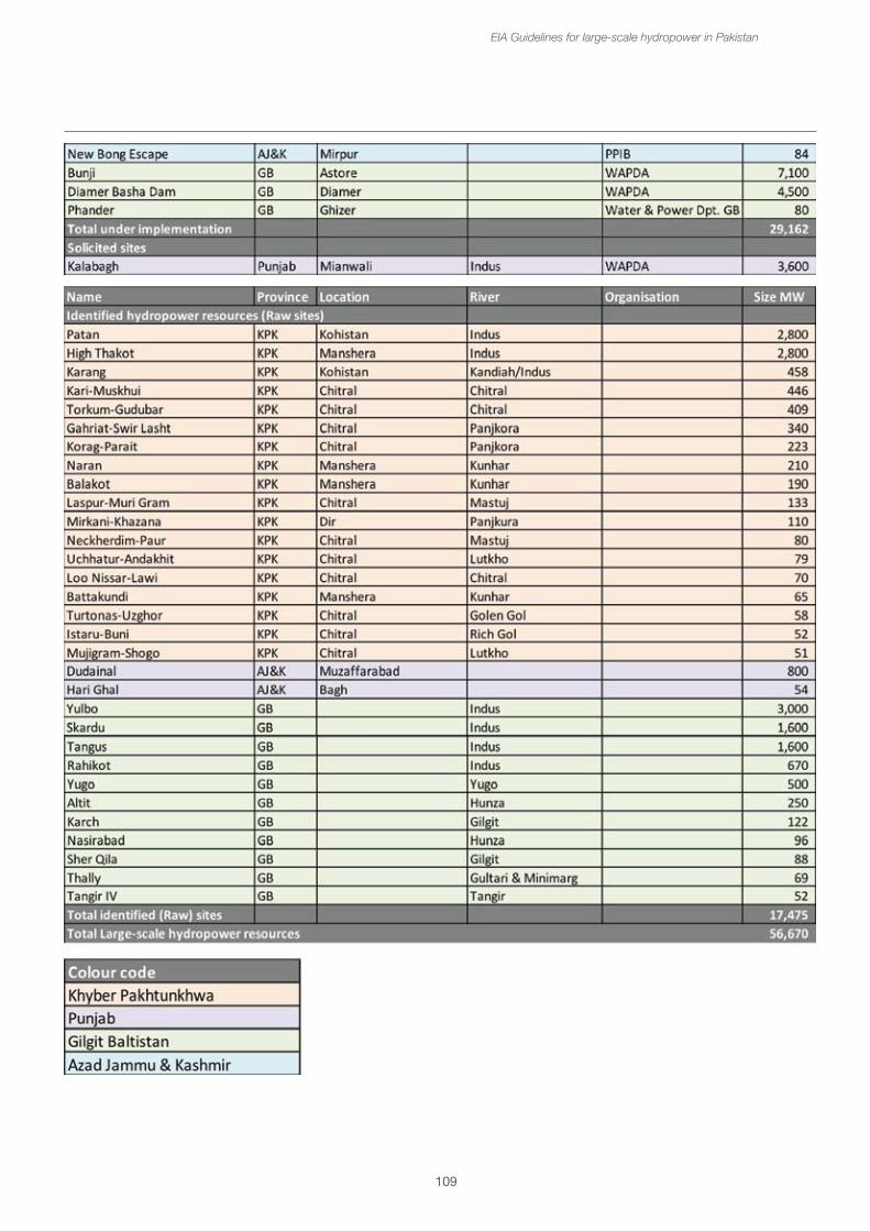
109
EIA Guidelines for large-scale hydropower in Pakistan
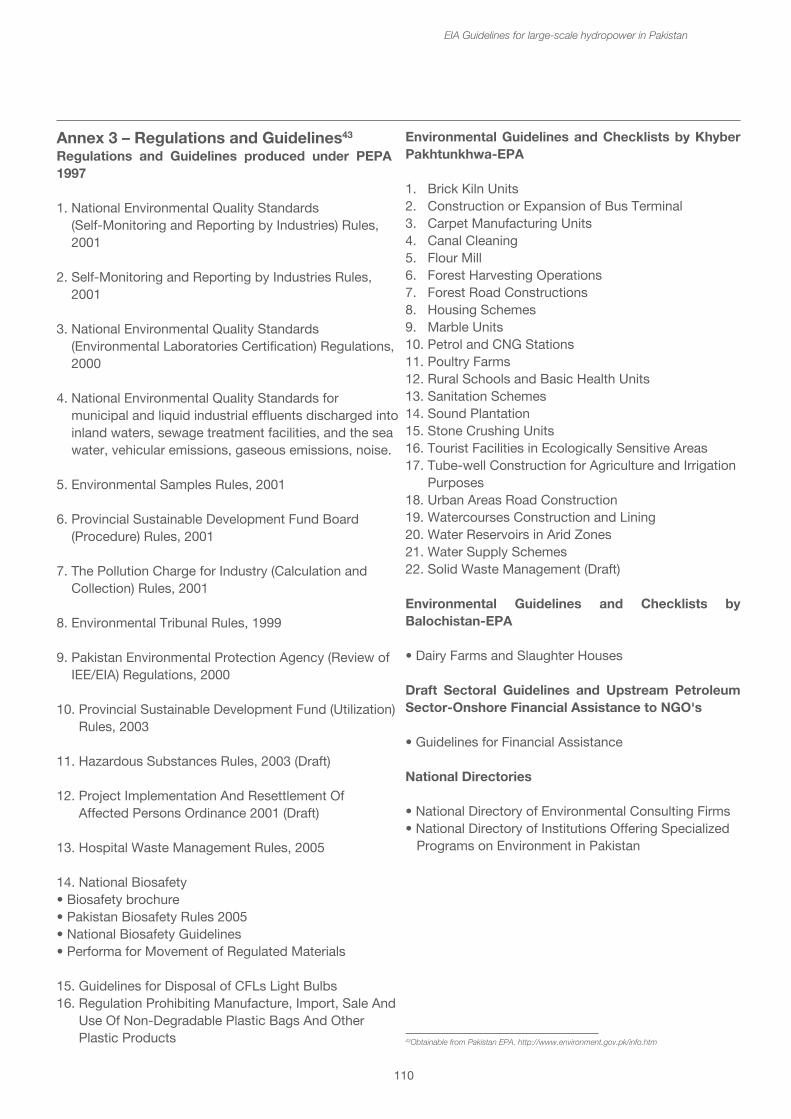
110
EIA Guidelines for large-scale hydropower in Pakistan
Annex 3 – Regulations and Guidelines43
Regulations and Guidelines produced under PEPA 1997
1. National Environmental Quality Standards (Self-Monitoring and Reporting by Industries) Rules, 2001
2. Self-Monitoring and Reporting by Industries Rules, 2001
3. National Environmental Quality Standards (Environmental Laboratories Certification) Regulations, 2000
4. National Environmental Quality Standards for municipal and liquid industrial effluents discharged into inland waters, sewage treatment facilities, and the sea water, vehicular emissions, gaseous emissions, noise.
5. Environmental Samples Rules, 2001
6. Provincial Sustainable Development Fund Board (Procedure) Rules, 2001
7. The Pollution Charge for Industry (Calculation and Collection) Rules, 2001
8. Environmental Tribunal Rules, 1999
9. Pakistan Environmental Protection Agency (Review of IEE/EIA) Regulations, 2000
10. Provincial Sustainable Development Fund (Utilization) Rules, 2003
11. Hazardous Substances Rules, 2003 (Draft)
12. Project Implementation And Resettlement Of Affected Persons Ordinance 2001 (Draft)
13. Hospital Waste Management Rules, 2005
14. National Biosafety • Biosafety brochure • Pakistan Biosafety Rules 2005 • National Biosafety Guidelines • Performa for Movement of Regulated Materials
15. Guidelines for Disposal of CFLs Light Bulbs16. Regulation Prohibiting Manufacture, Import, Sale And Use Of Non-Degradable Plastic Bags And Other Plastic Products
Environmental Guidelines and Checklists by Khyber Pakhtunkhwa-EPA
1. Brick Kiln Units 2. Construction or Expansion of Bus Terminal 3. Carpet Manufacturing Units 4. Canal Cleaning 5. Flour Mill 6. Forest Harvesting Operations 7. Forest Road Constructions 8. Housing Schemes 9. Marble Units 10. Petrol and CNG Stations 11. Poultry Farms 12. Rural Schools and Basic Health Units 13. Sanitation Schemes 14. Sound Plantation 15. Stone Crushing Units16. Tourist Facilities in Ecologically Sensitive Areas 17. Tube-well Construction for Agriculture and Irrigation Purposes 18. Urban Areas Road Construction 19. Watercourses Construction and Lining 20. Water Reservoirs in Arid Zones 21. Water Supply Schemes 22. Solid Waste Management (Draft) Environmental Guidelines and Checklists by Balochistan-EPA
• Dairy Farms and Slaughter Houses
Draft Sectoral Guidelines and Upstream Petroleum Sector-Onshore Financial Assistance to NGO's
• Guidelines for Financial Assistance
National Directories
• National Directory of Environmental Consulting Firms• National Directory of Institutions Offering Specialized Programs on Environment in Pakistan
43Obtainable from Pakistan EPA. http://www.environment.gov.pk/info.htm
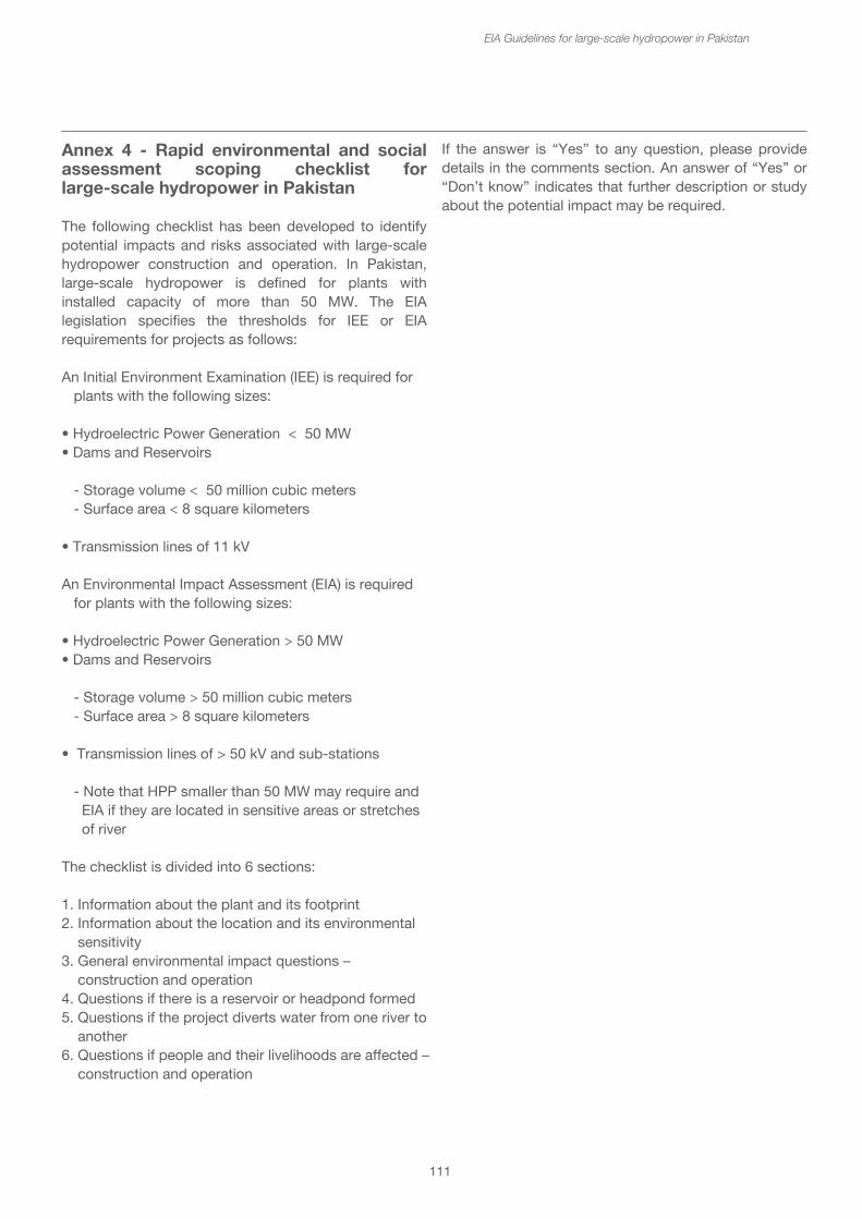
111
EIA Guidelines for large-scale hydropower in Pakistan
Annex 4 - Rapid environmental and social assessment scoping checklist for large-scale hydropower in Pakistan
The following checklist has been developed to identify potential impacts and risks associated with large-scale hydropower construction and operation. In Pakistan, large-scale hydropower is defined for plants with installed capacity of more than 50 MW. The EIA legislation specifies the thresholds for IEE or EIA requirements for projects as follows:
An Initial Environment Examination (IEE) is required for plants with the following sizes:
• Hydroelectric Power Generation < 50 MW• Dams and Reservoirs
- Storage volume < 50 million cubic meters - Surface area < 8 square kilometers
• Transmission lines of 11 kV
An Environmental Impact Assessment (EIA) is required for plants with the following sizes:
• Hydroelectric Power Generation > 50 MW• Dams and Reservoirs
- Storage volume > 50 million cubic meters - Surface area > 8 square kilometers
• Transmission lines of > 50 kV and sub-stations - Note that HPP smaller than 50 MW may require and EIA if they are located in sensitive areas or stretches of river
The checklist is divided into 6 sections:
1. Information about the plant and its footprint2. Information about the location and its environmental sensitivity3. General environmental impact questions – construction and operation4. Questions if there is a reservoir or headpond formed 5. Questions if the project diverts water from one river to another 6. Questions if people and their livelihoods are affected – construction and operation
If the answer is “Yes” to any question, please provide details in the comments section. An answer of “Yes” or “Don’t know” indicates that further description or study about the potential impact may be required.
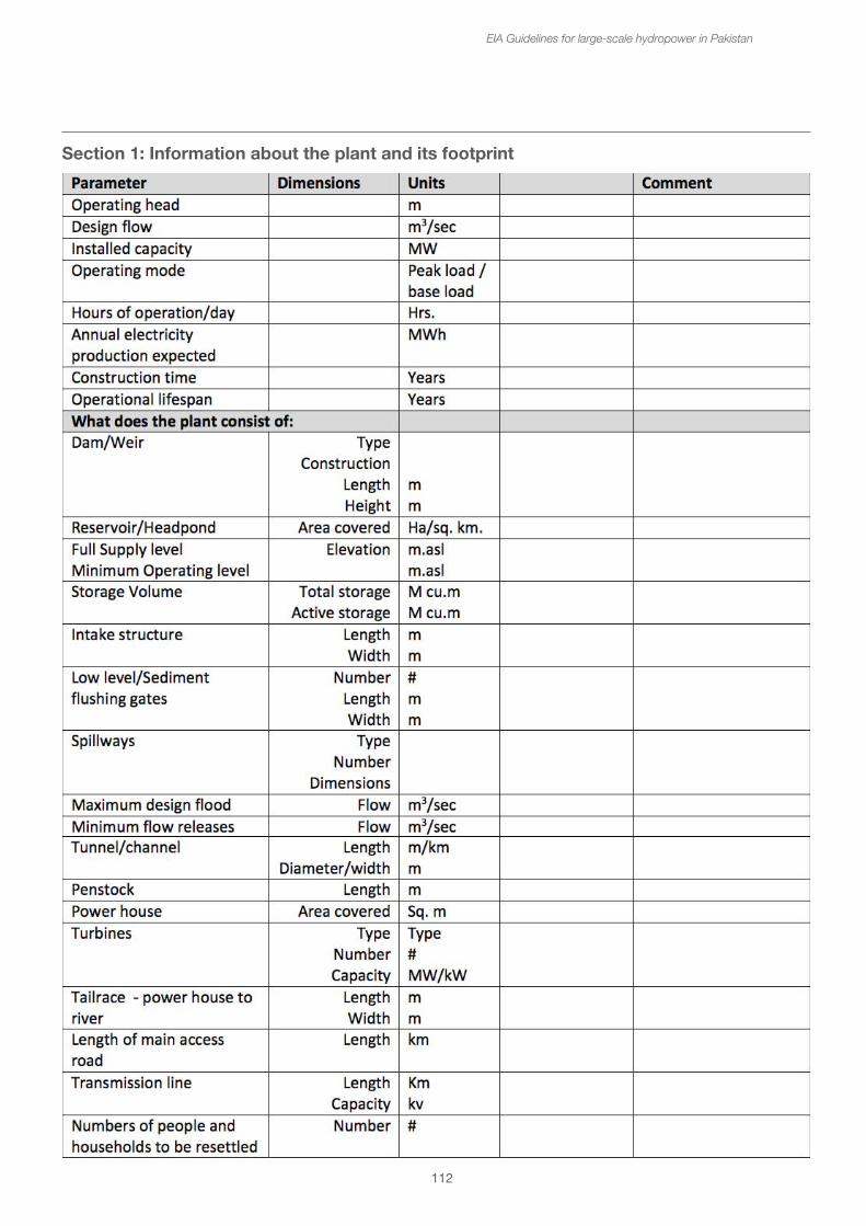
112
EIA Guidelines for large-scale hydropower in Pakistan
Section 1: Information about the plant and its footprint
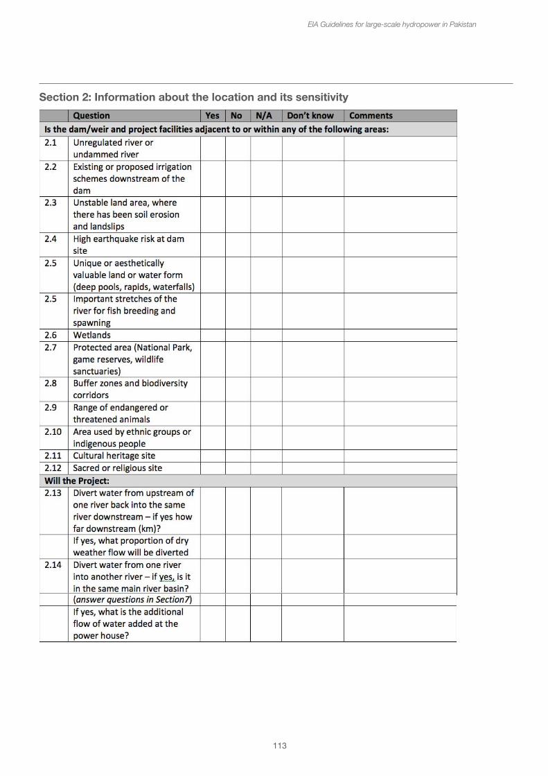
113
EIA Guidelines for large-scale hydropower in Pakistan
Section 2: Information about the location and its sensitivity
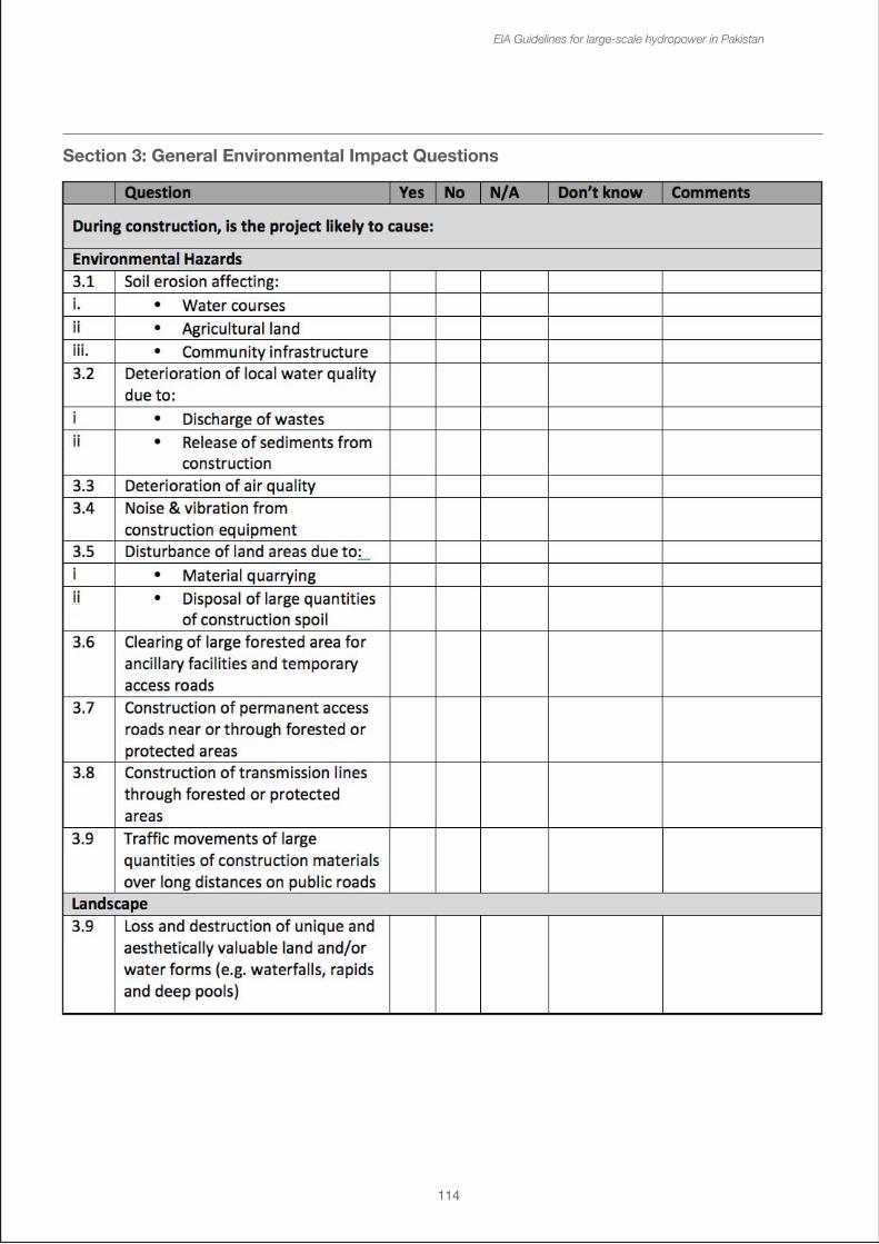
114
EIA Guidelines for large-scale hydropower in Pakistan
Section 3: General Environmental Impact Questions
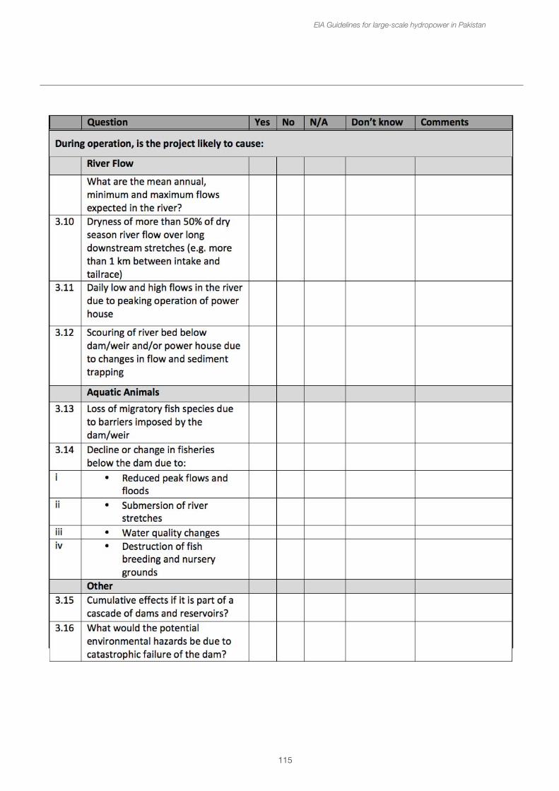
115
EIA Guidelines for large-scale hydropower in Pakistan
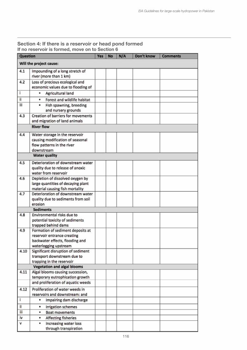
116
EIA Guidelines for large-scale hydropower in Pakistan
Section 4: If there is a reservoir or head pond formed If no reservoir is formed, move on to Section 6
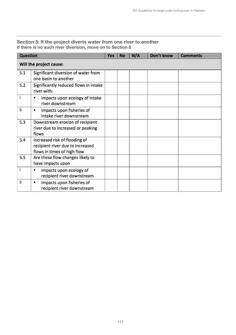
117
EIA Guidelines for large-scale hydropower in Pakistan
Section 5: If the project diverts water from one river to anotherIf there is no such river diversion, move on to Section 8
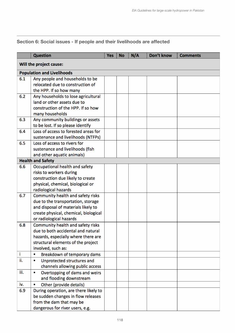
118
EIA Guidelines for large-scale hydropower in Pakistan
Section 6: Social issues - If people and their livelihoods are affected
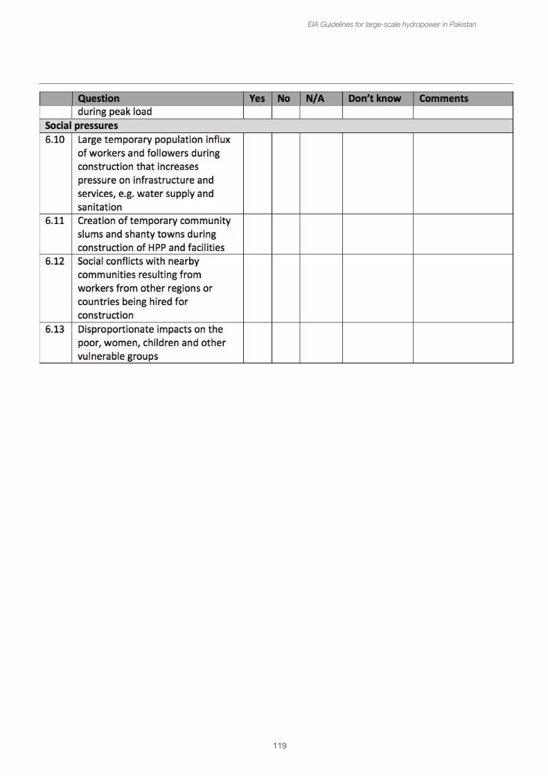
119
EIA Guidelines for large-scale hydropower in Pakistan
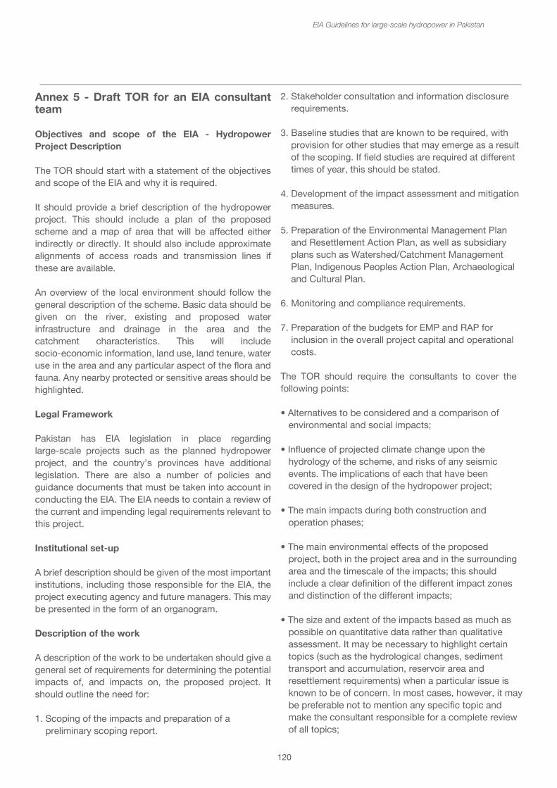
Annex 5 - Draft TOR for an EIA consultant team
Objectives and scope of the EIA - Hydropower Project Description
The TOR should start with a statement of the objectives and scope of the EIA and why it is required.
It should provide a brief description of the hydropower project. This should include a plan of the proposed scheme and a map of area that will be affected either indirectly or directly. It should also include approximate alignments of access roads and transmission lines if these are available.
An overview of the local environment should follow the general description of the scheme. Basic data should be given on the river, existing and proposed water infrastructure and drainage in the area and the catchment characteristics. This will include socio-economic information, land use, land tenure, water use in the area and any particular aspect of the flora and fauna. Any nearby protected or sensitive areas should be highlighted.
Legal Framework
Pakistan has EIA legislation in place regarding large-scale projects such as the planned hydropower project, and the country’s provinces have additional legislation. There are also a number of policies and guidance documents that must be taken into account in conducting the EIA. The EIA needs to contain a review of the current and impending legal requirements relevant to this project.
Institutional set-up
A brief description should be given of the most important institutions, including those responsible for the EIA, the project executing agency and future managers. This may be presented in the form of an organogram.
Description of the work
A description of the work to be undertaken should give a general set of requirements for determining the potential impacts of, and impacts on, the proposed project. It should outline the need for:
1. Scoping of the impacts and preparation of a preliminary scoping report.
2. Stakeholder consultation and information disclosure requirements.
3. Baseline studies that are known to be required, with provision for other studies that may emerge as a result of the scoping. If field studies are required at different times of year, this should be stated.
4. Development of the impact assessment and mitigation measures.
5. Preparation of the Environmental Management Plan and Resettlement Action Plan, as well as subsidiary plans such as Watershed/Catchment Management Plan, Indigenous Peoples Action Plan, Archaeological and Cultural Plan.
6. Monitoring and compliance requirements.
7. Preparation of the budgets for EMP and RAP for inclusion in the overall project capital and operational costs.
The TOR should require the consultants to cover the following points:
• Alternatives to be considered and a comparison of environmental and social impacts;
• Influence of projected climate change upon the hydrology of the scheme, and risks of any seismic events. The implications of each that have been covered in the design of the hydropower project;
• The main impacts during both construction and operation phases;
• The main environmental effects of the proposed project, both in the project area and in the surrounding area and the timescale of the impacts; this should include a clear definition of the different impact zones and distinction of the different impacts;
• The size and extent of the impacts based as much as possible on quantitative data rather than qualitative assessment. It may be necessary to highlight certain topics (such as the hydrological changes, sediment transport and accumulation, reservoir area and resettlement requirements) when a particular issue is known to be of concern. In most cases, however, it may be preferable not to mention any specific topic and make the consultant responsible for a complete review of all topics;
120
EIA Guidelines for large-scale hydropower in Pakistan
121
EIA Guidelines for large-scale hydropower in Pakistan
• Those groups that will benefit and those disadvantaged by the project;
• The impact on protected areas and any rare species of plant or animal in the area;
• The impact on human health;
• Cumulative impacts should be assessed both of several hydropower schemes in cascade in the river basin, and of the project in relation to other development activities within the province;
• Provincial and national transboundary impacts should be assessed;
• The control and management aspects of the project to determine if they will be effective;
• Dam safety aspects, including during normal operations and dam break analysis and emergency response;
• The present policy, institutional and legislative situation and future needs;
• The mitigating measures needed and how they should be incorporated into the project design;
• The monitoring and evaluation activities that are required to ensure that mitigating measures are implemented and future problems are avoided.
The impact zones for hydropower development should cover the following:
• Dam and power house construction site(s)• Quarries and spoil disposal sites• Channel or tunnel areas• Area to be inundated by the reservoir• Proposed host areas for resettled communities• Watershed or catchment area above the reservoir• Downstream riverine area• Access roads and transmission line alignment routes
The identification of ecologically and culturally sensitive areas within these impact zones will be important as well as communities and river users.
Public Participation Programme
The completion of the EIA must include a comprehensive public participation programme. The aim of public participation is to obtain broad public opinion of the project and to ensure that the concerns of the Interested and Affected Peoples are adequately addressed in the EIA and in the EMP and RAP. The proposals must provide detail of how such a programme will be designed and implemented.
Available information
The Terms of Reference should contain a review of the current status of information on the project and its effects. This will include which documents are available, what analysis has already taken place and some brief extracts when needed to prepare a good proposal. Furthermore, it is important to mention if certain information/data is not available and will have to be collected by the evaluator to ensure a realistic calculation of the offer. If a Strategic Environmental Assessment in the area or sector has already been carried out, this should be made available.
Main methods or techniques to be used
The TOR should require the consultant to propose the most appropriate methods of survey, consultation and impact assessment that they expect to use. They should also be asked to highlight any limitations or constraints involved with the application of these methods. The method statement in the proposals may be an important criterion for comparison between them and selection.
Possible methods and techniques of evaluation may include:
• Planning and structuring of evaluation: concept/issue mapping, stakeholder consultation, evaluability assessment, logic models, formative/developmental evaluation;
• Obtaining data: social survey, beneficiary survey, interviews, priority evaluation, focus groups, case studies, local evaluation, participatory approaches & methods, use of secondary source and administrative data, observational techniques;
122
EIA Guidelines for large-scale hydropower in Pakistan
• Analysing information: GIS spatial data analysis and mapping, input/output analysis, econometric models, regression analysis, experimental approaches, Delphi survey, SWOT;
• Tools to inform impact assessment: cost-benefit analysis, benchmarking, cost effectiveness analysis, economic impact assessment, gender impact assessment, multi-criteria analysis, expert panels.
Time schedule & reporting
The time schedule of the EIA should be provided with specific milestone dates expected for:
1. Public procurement started2. Deadline for proposals3. Inform EIA consultants of selection4. Scoping consultation meetings with stakeholders5. Presentation of Scoping report (if necessary)6. Baseline surveys, information gathering and analysis7. Progress meetings between developer and EIA team, and with regulators (if necessary)8. Presentation of Draft EIA report and EMP9. Presentation of the findings at stakeholder meetings10. Presentation of Final EIA report and EMP
The expected format of the EIA report and EMP may be provided in an Annex.
Indicative budget
The indicative budget for the EIA may be provided to help the consultants frame their proposals appropriately. The budgets proposed will be an important criterion for selection, but if there is a fixed maximum budget, the quality of the proposal in terms of method and expertise will be more important. There should be an additional budget set aside for surveys or studies that may emerge during the course of the EIA.
Required qualifications of the team
A hydropower EIA needs a multi-disciplinary team. It is suggested that the following disciplines may be required:
• Team leader (essential that this person has broad understanding of EIA, and a proven ability to integrate specialist studies)
Physical and biological impacts
• Hydrologist• Hydropower engineer• Geomorphologist/Soils scientist• Water quality specialist• Landuse/agricultural specialist• Forestry specialist• Terrestrial ecologist and wildlife specialists (for different taxonomic groups)• Aquatic ecologist• Fisheries specialist• Archaeologist
Social impacts and resettlement team
• Sociologists/social anthropologist• Health specialist• Resettlement expert• Environmental engineer• Evaluation engineer• Economists• Town planner/Planning engineer• Hydrologist• Hydro-geologist• GIS Specialist• Agronomist• Survey expert
The expertise may be sourced both internationally and nationally according to the level and complexity of the EIA, in which case the TOR should specify these requirements. The TOR should also specify the expected tasks to be undertaken by each team member. The required qualifications of each team member should be identified for comparisons of expertise provided in each proposal. These may include academic qualifications, previous experience with hydropower EIAs, previous experience in the area and with the local groups, their culture and language.
Public Participation Programme
The completion of the EIA must include a comprehensive public participation programme. The aim of public participation is to obtain broad public opinion of the project and to ensure that the concerns of the Interested and Affected Peoples are adequately addressed in the EIA and in the EMP and RAP. The proposals must provide detail of how such a programme will be designed and implemented.
Available information
The Terms of Reference should contain a review of the current status of information on the project and its effects. This will include which documents are available, what analysis has already taken place and some brief extracts when needed to prepare a good proposal. Furthermore, it is important to mention if certain information/data is not available and will have to be collected by the evaluator to ensure a realistic calculation of the offer. If a Strategic Environmental Assessment in the area or sector has already been carried out, this should be made available.
Main methods or techniques to be used
The TOR should require the consultant to propose the most appropriate methods of survey, consultation and impact assessment that they expect to use. They should also be asked to highlight any limitations or constraints involved with the application of these methods. The method statement in the proposals may be an important criterion for comparison between them and selection.
Possible methods and techniques of evaluation may include:
• Planning and structuring of evaluation: concept/issue mapping, stakeholder consultation, evaluability assessment, logic models, formative/developmental evaluation;
• Obtaining data: social survey, beneficiary survey, interviews, priority evaluation, focus groups, case studies, local evaluation, participatory approaches & methods, use of secondary source and administrative data, observational techniques;
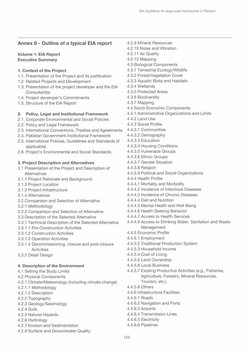
Physical and biological impacts
• Hydrologist• Hydropower engineer• Geomorphologist/Soils scientist• Water quality specialist• Landuse/agricultural specialist• Forestry specialist• Terrestrial ecologist and wildlife specialists (for different taxonomic groups)• Aquatic ecologist• Fisheries specialist• Archaeologist
Social impacts and resettlement team
• Sociologists/social anthropologist• Health specialist• Resettlement expert• Environmental engineer• Evaluation engineer• Economists• Town planner/Planning engineer• Hydrologist• Hydro-geologist• GIS Specialist• Agronomist• Survey expert
The expertise may be sourced both internationally and nationally according to the level and complexity of the EIA, in which case the TOR should specify these requirements. The TOR should also specify the expected tasks to be undertaken by each team member. The required qualifications of each team member should be identified for comparisons of expertise provided in each proposal. These may include academic qualifications, previous experience with hydropower EIAs, previous experience in the area and with the local groups, their culture and language.
123
EIA Guidelines for large-scale hydropower in Pakistan
Annex 6 - Outline of a typical EIA report
Volume 1: EIA Report Executive Summary
1. Context of the Project1.1. Presentation of the Project and its justification1.2. Related Projects and Development1.3. Presentation of the project developer and the EIA Consultant(s)1.4. Project developer’s Commitments1.5. Structure of the EIA Report
2. Policy, Legal and Institutional Framework2.1. Corporate Environmental and Social Policies2.2. Policy and Legal Framework2.3. International Conventions, Treaties and Agreements2.4. Pakistan Government Institutional Framework2.5. International Policies, Guidelines and Standards (if applicable)2.6. Project’s Environmental and Social Standards
3. Project Description and Alternatives3.1 Presentation of the Project and Description of Alternatives3.1.1 Project Rationale and Background3.1.2 Project Location3.1.3 Project Infrastructure3.1.4 Alternatives3.2 Comparison and Selection of Alternative3.2.1 Methodology3.2.2 Comparison and Selection of Alternative3.3 Description of the Selected Alternative3.3.1 Technical Description of the Selected Alternative3.3.1.1 Pre-Construction Activities3.3.1.2 Construction Activities3.3.1.3 Operation Activities3.3.1.4 Decommissioning, closure and post-closure Activities3.3.2 Detail Design
4. Description of the Environment4.1 Setting the Study Limits4.2 Physical Components4.2.1 Climate/Meteorology (including climate change)4.2.1.1 Methodology4.2.1.2 Description4.2.2 Topography4.2.3 Geology/Seismology4.2.4 Soils4.2.5 Natural Hazards4.2.6 Hydrology4.2.7 Erosion and Sedimentation4.2.8 Surface and Groundwater Quality
4.2.9 Mineral Resources4.2.10 Noise and Vibration4.2.11 Air Quality4.2.12 Mapping4.3 Biological Components4.3.1 Terrestrial Ecology/Wildlife4.3.2 Forest/Vegetation Cover4.3.3 Aquatic Biota and Habitats4.3.4 Wetlands4.3.5 Protected Areas4.3.6 Biodiversity4.3.7 Mapping4.4 Socio-Economic Components4.4.1 Administrative Organizations and Limits4.4.2 Land Use4.4.3 Social Profile4.4.3.1 Communities4.4.3.2 Demography4.4.3.3 Education4.4.3.4 Housing Conditions4.4.3.5 Vulnerable Groups4.4.3.6 Ethnic Groups4.4.3.7 Gender Situation4.4.3.8 Religion4.4.3.9 Political and Social Organizations4.4.4 Health Profile4.4.4.1 Mortality and Morbidity4.4.4.2 Incidence of Infectious Diseases4.4.4.3 Incidence of Chronic Diseases4.4.4.4 Diet and Nutrition4.4.4.5 Mental Health and Well Being4.4.4.6 Health Seeking Behavior4.4.4.7 Access to Health Services4.4.4.8 Access to Drinking Water, Sanitation and Waste Management4.4.5 Economic Profile4.4.5.1 Employment4.4.5.2 Traditional Production System4.4.5.3 Household Income4.4.5.4 Cost of Living4.4.5.5 Land Ownership4.4.5.6 Local Business4.4.5.7 Existing Productive Activities (e.g., Fisheries, Agriculture, Forestry, Mineral Resources, Tourism, etc.)4.4.5.8 Others4.4.6 Infrastructure Facilities4.4.6.1 Roads4.4.6.2 Navigation and Ports4.4.6.3 Airports4.4.6.4 Transmission Lines4.4.6.5 Electricity4.4.6.6 Pipelines
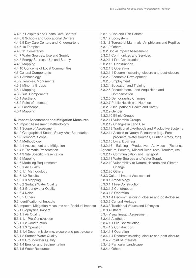
4.2.9 Mineral Resources4.2.10 Noise and Vibration4.2.11 Air Quality4.2.12 Mapping4.3 Biological Components4.3.1 Terrestrial Ecology/Wildlife4.3.2 Forest/Vegetation Cover4.3.3 Aquatic Biota and Habitats4.3.4 Wetlands4.3.5 Protected Areas4.3.6 Biodiversity4.3.7 Mapping4.4 Socio-Economic Components4.4.1 Administrative Organizations and Limits4.4.2 Land Use4.4.3 Social Profile4.4.3.1 Communities4.4.3.2 Demography4.4.3.3 Education4.4.3.4 Housing Conditions4.4.3.5 Vulnerable Groups4.4.3.6 Ethnic Groups4.4.3.7 Gender Situation4.4.3.8 Religion4.4.3.9 Political and Social Organizations4.4.4 Health Profile4.4.4.1 Mortality and Morbidity4.4.4.2 Incidence of Infectious Diseases4.4.4.3 Incidence of Chronic Diseases4.4.4.4 Diet and Nutrition4.4.4.5 Mental Health and Well Being4.4.4.6 Health Seeking Behavior4.4.4.7 Access to Health Services4.4.4.8 Access to Drinking Water, Sanitation and Waste Management4.4.5 Economic Profile4.4.5.1 Employment4.4.5.2 Traditional Production System4.4.5.3 Household Income4.4.5.4 Cost of Living4.4.5.5 Land Ownership4.4.5.6 Local Business4.4.5.7 Existing Productive Activities (e.g., Fisheries, Agriculture, Forestry, Mineral Resources, Tourism, etc.)4.4.5.8 Others4.4.6 Infrastructure Facilities4.4.6.1 Roads4.4.6.2 Navigation and Ports4.4.6.3 Airports4.4.6.4 Transmission Lines4.4.6.5 Electricity4.4.6.6 Pipelines
124
EIA Guidelines for large-scale hydropower in Pakistan
4.4.6.7 Hospitals and Health Care Centers4.4.6.8 Schools and Educational Centers4.4.6.9 Day Care Centers and Kindergartens4.4.6.10 Temples4.4.6.11 Cemeteries4.4.7 Water Sources, Use and Supply4.4.8 Energy Sources, Use and Supply4.4.9 Mapping4.4.10 Concerns of Local Communities4.5 Cultural Components4.5.1 Archaeology4.5.2 Temples, Monuments4.5.3 Minority Groups4.5.4 Mapping4.6 Visual Components4.6.1 Aesthetic4.6.2 Point of Interests4.6.3 Landscape4.6.4 Mapping
5. Impact Assessment and Mitigation Measures5.1 Impact Assessment Methodology5.1.1 Scope of Assessment5.1.2 Geographical Scope: Study Area Boundaries5.1.3 Temporal Scope5.1.4 Methodology5.1.4.1 Assessment and Mitigation5.1.4.2 Thematic Presentation5.1.4.3 Site Specific Presentation5.1.5 Mapping5.1.6 Modeling Requirements5.1.6.1 Air Quality5.1.6.1.1 Methodology5.1.6.1.2 Results5.1.6.1.3 Mapping5.1.6.2 Surface Water Quality5.1.6.3 Groundwater Quality5.1.6.4 Noise5.1.6.5 Others5.2 Identification of Impacts5.3 Impacts, Mitigation Measures and Residual Impacts5.3.1 Biophysical Impact5.3.1.1 Air Quality5.3.1.1.1 Pre-Construction5.3.1.1.2 Construction5.3.1.1.3 Operation5.3.1.1.4 Decommissioning, closure and post-closure5.3.1.2 Surface Water Quality5.3.1.3 Groundwater Quality5.3.1.4 Erosion and Sedimentation5.3.1.5 Water Resources
5.3.1.6 Fish and Fish Habitat5.3.1.7 Ecosystem5.3.1.8 Terrestrial Mammals, Amphibians and Reptiles5.3.1.9 Others5.3.2 Social Impact Assessment5.3.2.1 Communities and Services5.3.2.1.1 Pre-Construction5.3.2.1.2 Construction5.3.2.1.3 Operation5.3.2.1.4 Decommissioning, closure and post-closure5.3.2.2 Economic Development5.3.2.3 Employment5.3.2.4 Education and Training5.3.2.5 Resettlement, Land Acquisition and Compensation5.3.2.6 Demographic Changes5.3.2.7 Public Health and Nutrition5.3.2.8 Occupational Health and Safety5.3.2.9 Gender5.3.2.10 Ethnic Groups5.3.2.11 Vulnerable Groups5.3.2.12 Changes in Land Use5.3.2.13 Traditional Livelihoods and Productive Systems5.3.2.14 Access to Natural Resources (e.g., Forest products, Water Sources, Hunting Areas, etc.)5.3.2.15 Local Business5.3.2.16 Existing Productive Activities (Fisheries, Agriculture, Forestry, Mineral Resources, Tourism, etc.)5.3.2.17 Communication and Transport5.3.2.18 Water Sources and Water Supply5.3.2.19 Vulnerability to Natural Hazards and Climate Change5.3.2.20 Others5.3.3 Cultural Impact Assessment5.3.3.1 Archaeology5.3.3.1.1 Pre-Construction5.3.3.1.2 Construction5.3.3.1.3 Operation5.3.3.1.4 Decommissioning, closure and post-closure5.3.3.2 Cultural Heritage5.3.3.3 Traditional Values and Lifestyles5.3.3.4 Others5.3.4 Visual Impact Assessment5.3.4.1 Aesthetic5.3.4.1.1 Pre-Construction5.3.4.1.2 Construction5.3.4.1.3 Operation5.3.4.1.4 Decommissioning, closure and post-closure5.3.4.2 Point of Interests5.3.4.3 Particular Landscape5.3.4.4 Others
5.3.1.6 Fish and Fish Habitat5.3.1.7 Ecosystem5.3.1.8 Terrestrial Mammals, Amphibians and Reptiles5.3.1.9 Others5.3.2 Social Impact Assessment5.3.2.1 Communities and Services5.3.2.1.1 Pre-Construction5.3.2.1.2 Construction5.3.2.1.3 Operation5.3.2.1.4 Decommissioning, closure and post-closure5.3.2.2 Economic Development5.3.2.3 Employment5.3.2.4 Education and Training5.3.2.5 Resettlement, Land Acquisition and Compensation5.3.2.6 Demographic Changes5.3.2.7 Public Health and Nutrition5.3.2.8 Occupational Health and Safety5.3.2.9 Gender5.3.2.10 Ethnic Groups5.3.2.11 Vulnerable Groups5.3.2.12 Changes in Land Use5.3.2.13 Traditional Livelihoods and Productive Systems5.3.2.14 Access to Natural Resources (e.g., Forest products, Water Sources, Hunting Areas, etc.)5.3.2.15 Local Business5.3.2.16 Existing Productive Activities (Fisheries, Agriculture, Forestry, Mineral Resources, Tourism, etc.)5.3.2.17 Communication and Transport5.3.2.18 Water Sources and Water Supply5.3.2.19 Vulnerability to Natural Hazards and Climate Change5.3.2.20 Others5.3.3 Cultural Impact Assessment5.3.3.1 Archaeology5.3.3.1.1 Pre-Construction5.3.3.1.2 Construction5.3.3.1.3 Operation5.3.3.1.4 Decommissioning, closure and post-closure5.3.3.2 Cultural Heritage5.3.3.3 Traditional Values and Lifestyles5.3.3.4 Others5.3.4 Visual Impact Assessment5.3.4.1 Aesthetic5.3.4.1.1 Pre-Construction5.3.4.1.2 Construction5.3.4.1.3 Operation5.3.4.1.4 Decommissioning, closure and post-closure5.3.4.2 Point of Interests5.3.4.3 Particular Landscape5.3.4.4 Others
125
EIA Guidelines for large-scale hydropower in Pakistan
6. Risk Assessment6.1 Context of the Qualitative Risk Assessment6.2 Methodology6.3 Results of the Qualitative Risk Assessment6.3.1 Pre-Construction Phase6.3.2 Construction Phase6.3.3 Operation Phase6.3.4 Decommissioning, closure and post-closure Phase6.4 Results of the Quantitative Risk Assessment
7. Cumulative Impact Assessment7.1 Methodology and Approach7.2 Determination of Valued Ecosystem Components7.3 Determination of a Spatial and Temporal Framework7.4 Cumulative Impact Assessment7.5 Development of a Management Framework
8. Environmental and Social Management and Monitoring Plan8.1 Summary of the ESMMP8.2 Reference to ESMMP(Only a Summary of the ESMMP should be presented in that section to ensure that theESMMP is in line with the impact assessment and proposed mitigation measures. The fullESMMP should be presented in Volume 2.)9. Public Consultation and Disclosure9.1 Introduction9.2 Methodology and Approach9.3 Summary of Consultation Activities Undertaken9.4 Results of Consultation during Project Scoping9.5 Results of Consultation during preparation of EIA Report9.6 Results of Consultation on First Draft EIA Report9.7 Results of Consultation during EIA Review9.8 Recommendations for Ongoing Consultations
10. Development Plans10.1 Summary of Development Plans (if required)10.1.1 Watershed Management Plan (for Hydroelectric power or Dam Project)10.1.2 Biomass Removal Plan (for Hydroelectric power or Dam Project)10.1.3 Resettlement Action Plan10.1.4 Stakeholder Engagement Plan10.1.5 Livelihood Restoration Plan10.1.6 Community Development Plan10.1.7 Vulnerable Groups Development Plan10.1.8 Others10.2 Reference
Appendices: (separate Volumes)Appendix 1: MappingProject DescriptionDescription of the EnvironmentImpacts and Mitigation MeasuresAppendix 2: Description of the ProjectFlow DiagramsLayoutsOthersAppendix 3: Specialist ReportsFisheries StudySedimentation and Erosion StudySocio-Economic StudyOthersAppendix 4: Modeling Reports (if required)Air QualitySurface Water QualityGroundwater QualityNoiseOthersAppendix 5: Public Consultation and Disclosure, Minutes of Meetings
Appendices: (separate Volumes)Appendix 1: MappingProject DescriptionDescription of the EnvironmentImpacts and Mitigation MeasuresAppendix 2: Description of the ProjectFlow DiagramsLayoutsOthersAppendix 3: Specialist ReportsFisheries StudySedimentation and Erosion StudySocio-Economic StudyOthersAppendix 4: Modeling Reports (if required)Air QualitySurface Water QualityGroundwater QualityNoiseOthersAppendix 5: Public Consultation and Disclosure, Minutes of Meetings
126
EIA Guidelines for large-scale hydropower in Pakistan
Annex 7 - Outline of a typical Environmental Management Plan44
PART I GENERAL MATTERS0.0 Terms and Definitions1.0 General Overview2.0 Project developer’s environmental and social policies and commitments3.0 Legal Requirements and Environmental and Social Policies and Commitments3.1 Applicable Laws3.2 Contractual and Corporate Commitments3.3 Governing Parameters4.0 EMP Organizational Structure, Roles and Responsibilities5.0 Authorities and other Stakeholders
PART II PLANS AND PROGRAMS6.0 Construction Phase6.1 Description of Construction Works6.2 Management and Monitoring Plans6.2.1 Site or Area Specific Plans6.2.2 Thematic Plans and Programs7.0 Operational Phase7.1 Description of Operations7.2 Management and Monitoring Plans7.2.1 Site or Area Specific Plans7.2.2 Thematic Plans and Programs8.0 Decommissioning, Closure and Post-closure8.1 Description of Decommissioning, Closure and Post-closure8.2 Management and Monitoring Plans8.2.1 Site or Area Specific Plans8.2.2 Thematic Plans and Programs
PART III: PROCEDURES AND SUPPORT PROGRAMS9.0 Management Procedures9.1 Competence, training and awareness9.2 Internal and External Communication9.3 Documentation (GIS, GPS, photos, video recording, forms and reports, etc.)9.4 Control of Documents9.5 Operational Control9.6 Emergency preparedness and response10.0 Checking10.1 Monitoring, measurements10.2 Evaluation of Compliance10.3 Non-compliance, corrective action and prevention action10.3.1 Non-compliance Level and Communication10.3.2 Non-compliance procedure10.4 Control of Records10.5 Internal Audit10.6 External Audit
11.0 Management review12.0 Cross Reference of ISO 14001:2004 Requirements 13.0 Cross Reference to Standards
Volume 3: Development Plans (if required)• Watershed Management Plan• Biomass Removal Plan• Resettlement Action Plan• Stakeholder Engagement Plan• Livelihood Restoration Plan• Community Development Plan• Vulnerable Groups Development Plan• Others
44Adapted from ESIA Guidelines for Lao PDR
127
EIA Guidelines for large-scale hydropower in Pakistan
Part II: AppendicesThe appendices should contain supplementary information. The appendices typically include material that was used to develop the EAP and information that can be used to assist with decision-making during an incident (e.g., detailed operation and maintenance requirements, dam break information and analyses, record of plan reviews and updates, plan distribution list, incident tracking forms). When developing the appendices, dam owners, in coordination with emergency management authorities, should consider including supporting information that will help them respond rapidly and effectively to an incident.
Annex 8 - Outline of a Disaster management plan
The following suggested contents list for an Emergency Action Plan is taken from the USA’s Federal Guidelines for Dam Safety – Emergency Action Planning, FEMA 64, July 2013.45
Part I: EAP InformationI. Summary of EAP ResponsibilitiesII. Notification FlowchartsIII. Statement of PurposeIV. Project DescriptionV. EAP Response Process
• Step 1: Incident Detection, Evaluation, and Emergency Level Determination• Step 2: Notification and Communication• Step 3: Emergency Actions• Step 4: Termination and Follow-upVI. General Responsibilities• Dam Owner Responsibilities• Notification and Communication Responsibilities• Evacuation Responsibilities• Monitoring, Security, Termination, and Follow-up Responsibilities• EAP Coordinator ResponsibilitiesVII. Preparedness• Surveillance and Monitoring• Evaluation of Detection and Response Timing• Access to the Site• Response during Periods of Darkness• Response during Weekends and Holidays • Response during Adverse Weather • Alternative Sources of Power • Emergency Supplies and Information • Stockpiling Materials and Equipment • Coordination of Information • Training and Exercise • Alternative Systems of Communication • Public Awareness and Communication
VIII. Inundation Maps
45http://www.fema.gov/media-li-brary-data/5b20db599c212f77fd5e85d256f471a3/EAP+Federal+Guidelines_FEMA+P-64.pdf