Embed Size (px)
Citation preview

Edgware SPD
Transport Study
Page 1
Edgware Supplementary
Planning Document
Transport Study
December 2020

Edgware SPD
Transport Study
Page 2
Contents
1 Introduction 3
2 Existing transport and movement context 4
3 Policy and best practice 8
4 Future considerations 16
5 SPD transport objectives 20
6 SPD development proposals 23
7 SPD development impact assessment 28
8 SPD transport measures 33
9 Delivery and Timescales 41

Edgware SPD
Transport Study
Page 3
1 Introduction
General introduction
Urban Flow has been commissioned by Barnet Council to prepare a transport study in
support of a Supplementary Planning Document (SPD) for Edgware town centre and
the immediate surrounding area.
Figure 1 identifies the SPD area boundary.
Figure 1 SPD transport study boundary
Definition and scope of the SPD Transport Study
This transport study:
• Provides a detailed overview of the transport and movement context in
Edgware town centre and immediate wider area;
• identifies issues and potential opportunities for change to support the SPD area,
focussing in particular on maximising movement by sustainable travel modes;
• reviews the existing policy context at a borough and London scale;
• identifies overarching SPD transport objectives;
• outlines proposed SPD development opportunities;
• assesses the transport/movement implications of the proposed SPD
development sites; and
• outlines a range of transport measures and interventions for the future.
Edgware
LU station
Broadwalk
Centre

Edgware SPD
Transport Study
Page 4
2 Existing transport and movement context
This section of the report provides an overview, by mode, of the existing transport and
movement context within, and immediately surrounding, the SPD study area.
A detailed ‘baseline appendix’ is provided at the end of this report; this explores key
issues in more detail. Primary data sources include site audits, data collected
specifically for this study (including parking activity), other available data held by
Barnet Council and Transport for London’s (TfL’s) ‘Playbook’ and ‘City Planner’ tools.
Walking
• The highest concentrations of pedestrian activity are found along the Station
Road corridor;
• Survey data reveals highest flows around the tube station and by the shopping
centre – the evening peak sees flows approximately twice as high as the
morning peak;
• There are a substantial number of car-only switchable trips (trips currently made
by car with potential to be walked instead) within the area – this is informed by
high levels of assessed ‘walkability’;
• The tube lines create a major barrier to east-west movement and sever the
eastern part of the SPD area from the town centre;
• There are a number of pedestrian links in the town centre that provide short-
cuts to residential areas but these routes are often narrow and poorly lit; and
• Dedicated pedestrian crossing provision is missing at key junctions (notably High
Street / Station Road) with ad hoc crossing activity taking place on many busy
links across the SPD area.
Lack of pedestrian crossing Narrow, poorly lit pedestrian link Ad-hoc pedestrian crossing
phase at signalised junction (Church Way) on High Street
Cycling
• Very low levels of cycling activity were observed – peak link flows being typically
in the order of 1-4 cyclists per hour in each direction;
• This reflects Barnet more generally where only 2% of trips in the borough are
currently cycled, much lower neighbouring Haringey where 8% of trips are
cycled;
• Cycle lane and other infrastructure provision within the SPD area is very limited;
• The ‘cycleability’ of the SPD area varies from low to medium. There are a
number on non-cycleable, pedestrian only routes where cyclists need to

Edgware SPD
Transport Study
Page 5
dismount. Station Road and High Street are the least cycleable due to wide
carriageways, high vehicle speeds and no cycling infrastructure;
• Based on TfL data there is a low–medium cycling potential within the SPD area.
This suggests that a modest number of trips currently taking places by non-
cycling modes could be switched to cycling; and
• The cycle racks in front of Edgware Station are well-used throughout the day.
Additional bicycles were observed parked along the railings suggesting that
the demand for commuter cycle parking exceeds existing supply.
No cycling permitted along Vehicle dominated Cycle parking utilising
Church Way cycling environment extensive guard railing
Public Transport - bus
• Edgware town centre is very well-connected - the area along Station Road and
by Edgware station scores between PTAL 5 and 6b (the highest rating), derived
in part from the good provision of frequent bus services;
• Edgware bus station is the main bus hub for the area catering for local trips, an
interchange for longer journeys, and interchange with the underground station
– the quality of public realm in/around the station is poor and constrained
however;
• More widely there is a good distribution of bus stops across the SPD area with
nearly the whole area within 400m walk of a stop;
• Based on TfL forecasts, it is expected that there will be a substantial increase in
bus boarding and alighting activity in the SPD area; and
• Bus Speeds are slower in the PM peak than AM peak – c.7mph during the PM
peak on Station Road and the High Street and c.9 mph in the AM.
Edgware bus station Station Road bus stop provision Bus stands and garaging
Schematic route plans are included in the ‘baseline appendix’.

Edgware SPD
Transport Study
Page 6
Public Transport - tube
• Edgware LU station operates as an integrated interchange with the adjacent
bus station – approximately one third of the tube station users arrive by bus
during the AM peak;
• Whilst busy at peak times, and despite recent growth in entry/exit flows, the
station currently operates within capacity – however the trains themselves are
highly congested during peak hours towards/from central London; and
• Despite the station arrival area prioritising vehicles over pedestrians there is
peak period congestion and queuing onto Station Road.
Station arrival prioritises vehicles Pick-up / drop-off area congested Alternative station entrance
over pedestrians leading to queuing onto Station Rd provides better interchange with
tube station
Highway network and parking
• Analysis by TfL indicates that Barnet is the borough with the highest number of
trips currently driven which could be converted to walking or cycling - two thirds
of car trips in Barnet are under 5km, which could be cycled in 20 minutes;
• Surveys of existing traffic flows were undertaken which showed that the morning
peak (8-9am) is the busiest period:
o Station Road flows are in the order of 1,500 vehicles per hour in both
directions;
o Other key routes into the SPD area (Edgwarebury Lane, Hale Lane,
Whitchurch Lane) have lower flows of c.1,000 vehicles per hour but are still
busy and often congested with queuing;
• Approximately 3,000 vehicles (two-way) use the bus station/garaging link every
day (7am-7pm) which highlights the importance of managing bus operations;
• Based on TfL forecasting data, by 2041, a significant increase of 20-40% in
car/taxi flows is expected along Station Road, Edgwarebury Lane, Hale Lane
and High Street;
• Decreases in traffic speeds along Station Road and High Street suggests a
worsening highway performance in recent years – forecasted increases in
vehicle delays are substantial, potentially greater than 40% in the heart of the
SPD area;
• Freight flows are currently very low within the SPD area – although significant
growth is forecast in future years;
• Very few KSI casualties were recorded in the SPD area. The spatial distribution
of these collisions identified the Station Road / High Street junction as the
primary area of road safety concern;

Edgware SPD
Transport Study
Page 7
• Noise and air pollution are problematic, notably along the Station Road and
High Street corridors;
• On-street parking in the SPD area is covered by several Controlled Parking
Zones (CPZs) that manage residential, pay-for and other parking;
• Surveys of on-street parking stress show a varied pattern by street by time of day
– notwithstanding localised hotspots of parking activity, overall there was spare
capacity observed at all times of day;
• There is a single off-street car park serving the town centre which offers 1,150
short-stay and long-stay spaces. This has the effect of focussing car park traffic
onto a single access junction; and
• The long-stay commuter off-street parking is used to capacity whilst the short-
stay shopper parking sees lower levels of utilisation, typically 60% full on a
weekday.
Peak hour congestion and Extensive off-street parking Trolleying goods to retail units
queuing on Whitchurch Lane supply behind Sainsburys on Station Road
These issues (and opportunities) have been critically reviewed and incorporated into a
range of SPD transport objectives (Chapter 4) and then specific measures and
interventions (Chapter 7).

Edgware SPD
Transport Study
Page 8
3 Policy and best practice
This section provides an overview of the current national and local government policies
that have, and will continue to, inform the development of this study. Reviewing these
policies helps to ensure that the SPD is developed and implemented in accordance
with established policy aims and objectives.
London Policies
London Plan (2020 ‘Intend to Publish’)
• Development Plans should deliver patterns of land use that
facilitate residents making shorter, regular trips by walking
or cycling
• More active traffic management, including demand
management measures
• Closer coordination of transport policy and investment
• An appropriate balance being struck between promoting
new development and preventing excessive car parking
provision that can undermine cycling, walking and public transport use
A City for All Londoners
• Roadmap to become a zero-carbon city by 2050
• Aim to drastically reduce dangerous emissions
• Vibrant town centres and high streets
• Short journeys on foot or bike
• More space for pedestrians
• ‘Turn up and go’ bus and rail services
• More efficient road network and less traffic on local roads
• Reduced car use
Mayor of London’s Transport Strategy
• Improving walking and cycling environments and
providing better bus and rail services will reduce car
dependency
• Healthy Streets and Healthy People
• Safe, secure, clean and green streets
• Well-connected, accessible and safe public transport
• High density, mixed-use developments
• People choose to walk and cycle
• Car-free and car-lite places
• Carbon-free travel
• Efficient freight

Edgware SPD
Transport Study
Page 9
Vision Zero
• Safe speeds - Lowering speeds is fundamental to reducing
road danger because a person is five times less likely to be
fatally injured if hit at 20mph than at 30mph
• Safe street design - Ensuring all transport infrastructure
projects in London contribute to reducing road danger;
attention will focus particularly on areas of highest risk such
as busy junctions and roundabouts
• Safe vehicles - Making sure those vehicles that need to use
London’s streets are as safe as possible
• Safe behaviour - Improving the behaviour of all road users, especially drivers of
motorised vehicles
• Post collision - Reducing the severity of injuries when a collision occurs,
supporting victims of road crime, and developing a clearer picture of how and
why collisions occur
Healthy Streets
Healthy Streets approach is a framework that underlines Mayor’s Transport
Strategy. Its objectives include improving air quality, reducing congestion and
supporting London’s communities to be greener, healthier and more attractive
places to live, work, play and do business.
This can be achieved by considering Healthy Streets indicators in order to
improve the experience of using London’s streets and encourage people to
spend time there:
Figure 2 Healthy Streets Indicators
• Pedestrians from all walks of life – streets should be inclusive and reflect the
full diversity of society
• Easy to cross - high quality provision of suitable crossing facilities can make
walking and cycling more appealing

Edgware SPD
Transport Study
Page 10
• Shade and shelter – protection from extreme conditions can encourage
people to travel actively irrespective of the weather
• Places to stop and rest – resting places are essential part of inclusive design,
and can bring benefit to local businesses and communities, by
encouraging people to spend time and socialise
• Not too noisy – less traffic-related noise, achieved by reducing motor
vehicle dominance, can encourage people to interact and travel actively
and improve their health and well-being
• People choose to walk, cycle and use public transport – cycling, walking
and public transport should be the most attractive and enjoyable travel
modes
• People feel safe – people should feel safe on the streets at any time of day
and night. Perception of crime and road safety concerns might discourage
them from active travel and public transport
• Things to see and do – an attractive offer of local facilities and services can
encourage people to travel actively and be less car-dependent
• People feel relaxed – good quality urban design and clean, well-
maintained spaces can reduce stress and encourage people to walk and
cycle
• Clean air – improved air quality, achieved by reducing the number of
polluting vehicles, helps reduce health inequalities, improve health and
well-being
London Borough of Barnet
At a more local, Borough level there is a wide range of relevant policies and strategies
that relate to growth, transport and other related considerations.
Barnet’s Draft Local Plan (2020)
In March 2020 Barnet Council undertook a Regulation 18
consultation on a Draft Local Plan Preferred Approach. The new
Local Plan “sets out a vision for how Barnet will change as a
place over the next 15 years and forms a strategy which
emphasises the borough’s attractiveness as a place to live, work
and visit.”
Key draft transport policies are:
• Policy TRC01 – support [TfL’s] Healthy Streets Approach,
improving street lighting, security coverage and accessibility along new walking
and cycling routes, transport interchanges and around bus stops
• Policy TRC02 – promote delivery of new transport infrastructure to support the
travel needs of a growing population
• Policy TRC03 – expect development to provide parking in accordance with
London Plan standards, except in the case of residential development

Edgware SPD
Transport Study
Page 11
Barnet’s Local Plan (2012)
• Protecting Barnet’s character and amenity, by promoting
development that respects local context and distinctive
character
• High-quality, accessible and inclusive design
• Reducing the borough’s carbon footprint where possible
particularly in new development
• Protecting and enhancing Barnet’s heritage – with The
Burroughs and Church End listed as one of the
Conversation Areas
• The council expects proposals for student accommodation to demonstrate
that they support educational establishments within Barnet and meet an
identified local need. Provision for students should be located in accessible
locations
• Ensuring a suitable mix of appropriate uses as part of development within the
town centres to support their continued vitality and viability
• Maintaining local centres and parades
• Enabling inclusive and integrated community and education facilities and uses
• Protecting and enhancing Barnet’s open spaces
• Providing safe, effective and efficient travel
• Ensuring more efficient use of the local road network and delivering more
environmentally friendly transport networks
• Taking a comprehensive approach to tackling school run
• Improving health and well-being
At the time of this SPD being prepared (March 2020), Barnet Council is reviewing and
updating the Borough’s planning policies in a new, revised Local Plan. The first
‘preferred policy approach’ stage of this process is currently underway. The new Local
Plan will eventually replace the existing Local Plan, currently expected in late 2021.
One Barnet: A Sustainable Community Strategy for Barnet (2010 - 2020)
• This strategy document aims to ensure that Barnet
remains a successful London suburb – delivering
sustainable housing growth, keeping Barnet moving,
supporting enterprise, providing people with the
right skills to access employment opportunities,
creating an environmentally responsible, clean and
green suburb
• Strong, safe communities for everyone – reducing crime and anti-social
behaviour and ensuring that residents feel safe, creating strong and cohesive
communities
• Investing in children, young people and families – ensuring safety of children
and young people, narrowing the gap through targeting at young people at
risk of not fulfilling their potential, preventing ill health and unhealthy lifestyles
• Healthy and independent living - ensuring better health and healthy lives for
all and better access to local health services, promoting choice and
maximising independence of those needing greatest support

Edgware SPD
Transport Study
Page 12
Draft Local Implementation Plan (LIP) (2018)
• The Draft LIP shares many objectives articulated in the Mayor’s Transport
Strategy – but acknowledging that Barnet presents unique challenges that may
require alternative solutions
• In the context of The Mayor’s Transport Strategy’s overarching objective for 80%
of all trips in London to be on foot, by cycle or public transport by 2041, Barnet’s
mode share must increase from 59% today to 72% in 2041
• Encouraging healthier lifestyles through promoting physical activity, enabling
supporting and promoting active travel and improving public transport links to
facilities
• Applying Healthy Streets principles
• Seeking to achieve the Vision Zero ambition of zero Killed or Seriously Injured
Road Traffic Casualties by 2041
• Promoting, enabling and supporting more sustainable travel to school,
workplaces and other destinations
• Improving air quality in Barnet and protecting residents and visitors, especially
children from exposure to pollution
• Securing new and revised public transport routes to support the growth of the
borough, particularly addressing the challenges presented by orbital travel and
travel to neighbouring areas and orbital connectivity across the borough
• Facilitating the introduction of step-free facilities at stations and accessible bus
stops to help make public transport accessible for all passengers, directly or
through support of TfL and National Rail proposals and development
opportunities
• Securing significant regeneration and growth across the borough’s opportunity
areas based upon sustainable development principles with the majority of trips
carried out via public transport on foot and by cycle with a reduced reliance
on the private car
Air Quality Action Plan (2017 – 2022)
• Barnet’s Air Quality Action Plan aims to raise awareness of the causes of
pollution and to drive behavioural change as well as to reduce exposure to air
pollution
• Reducing the impact of delivery servicing and freight
• Promoting cleaner transport
• Encouraging a change to walking, cycling and ultra-low emission vehicles
(such as electric)
Edgware SPD
Transport Study
Page 13
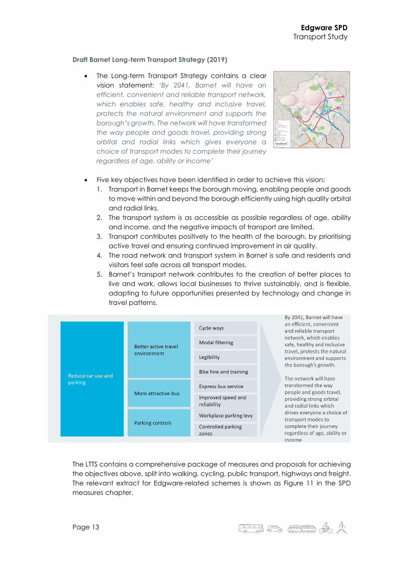
Draft Barnet Long-term Transport Strategy (2019)
• The Long-term Transport Strategy contains a clear
vision statement: ‘By 2041, Barnet will have an
efficient, convenient and reliable transport network,
which enables safe, healthy and inclusive travel,
protects the natural environment and supports the
borough’s growth. The network will have transformed
the way people and goods travel, providing strong
orbital and radial links which gives everyone a
choice of transport modes to complete their journey
regardless of age, ability or income’
• Five key objectives have been identified in order to achieve this vision:
1. Transport in Barnet keeps the borough moving, enabling people and goods
to move within and beyond the borough efficiently using high quality orbital
and radial links.
2. The transport system is as accessible as possible regardless of age, ability
and income, and the negative impacts of transport are limited.
3. Transport contributes positively to the health of the borough, by prioritising
active travel and ensuring continued improvement in air quality.
4. The road network and transport system in Barnet is safe and residents and
visitors feel safe across all transport modes.
5. Barnet’s transport network contributes to the creation of better places to
live and work, allows local businesses to thrive sustainably, and is flexible,
adapting to future opportunities presented by technology and change in
travel patterns.
The LTTS contains a comprehensive package of measures and proposals for achieving
the objectives above, split into walking, cycling, public transport, highways and freight.
The relevant extract for Edgware-related schemes is shown as Figure 11 in the SPD
measures chapter.

Edgware SPD
Transport Study
Page 14
Barnet Corporate Plan (2019 – 2024)
• The latest Corporate Plan seeks to achieve three main
outcomes:
• ‘A pleasant, well maintained Borough that we
protect and invest in’
• ‘Our residents live happy, healthy, independent
lives with the most vulnerable protected’
• ‘safe and strong communities where people get
along well’
• The plan seeks to keep the borough moving, including
improvements to roads and pavements – achieved through improving the
condition of our roads and pavements, encouraging the use of public
transport, walking and cycling through the ‘healthy streets’ approach, lobbying
for improvements to public transport and bringing back disused public transport
such as rail lines, developing a cycle network to major destinations in the
borough without impeding main traffic routes, promoting and continuing to roll
out electric vehicle charging and car clubs, using enforcement to increase
compliance and support traffic to move smoothly and safely.
• Supporting our residents who are older, vulnerable or who have disabilities, to
remain independent and have a good quality of life
• Encouraging residents to lead active and healthy lifestyles and maintain their
mental wellbeing
• Tackling anti-social behaviour and environmental crime
• Supporting local businesses to thrive
Barnet Growth Strategy (2019 – 2024)
• The Growth Strategy sets out the Council’s role and priorities for regeneration,
development and business, employment and skills activity across the borough
from 2019 to 2030, including:
• Enabling new and enhanced public transport connections
by improving orbital connectivity and interchange
between rail lines, reducing congestion and improving
transport accessibility
• Delivering healthier street design to support all forms of
travel by responding to demographic and cultural
changes to enhance travel choices, promote active travel
and improve safety
• Delivering a cleaner, greener and more pleasant borough
by reduced congestion and improved air quality, by encouraging the use of
more sustainable forms of transport and supporting the transition to electric
vehicles and other technologies as the emerge
• Implementing state-of-the-art digital infrastructure by working with public and
private sector partners to incorporate this into regeneration schemes, council
assets and where local employers need it, such as across our town centres.

Edgware SPD
Transport Study
Page 15
Summary
There is a wide range of relevant policies and strategies that relate to growth,
transport and other related considerations. In particular, Barnet Council’s vision for
transport in the borough shares many of the same goals articulated in the Mayor’s
Transport Strategy (MTS) - including improving air quality, reducing car dependency,
and enabling more Londoners to walk and cycle.
Figure 31 shows a summary of this close overlap between the MTS and Barnet
Council’s Local Implementation Plan (LIP).
Figure 3 Policy objectives summary: MTS & LIP
1 Sourced from: Draft Long-term Transport Strategy, Barnet Council, November 2019
Edgware SPD
Transport Study
Page 16
4 Future considerations
In a rapidly changing world it is particularly important to attempt to anticipate how
future changes in technology, behaviour and practices may influence the
arrangement of streets and places over the next 10-20 years:
• How will major development such as that proposed in this SPD be reflected in
movement patterns locally and more strategically and will significant social and
behavioural shifts take place following the COVID-19 pandemic?
• Is it acceptable to allow vehicles, particularly large goods vehicles, unrestricted
access for deliveries and/or through movement?
• Will pedestrian and cyclist–shared streets become the default expectation in
town centres?
• Or perhaps changes will be small-scale, incremental and largely
unremarkable?
Although the future is uncertain, taking account of such possibilities and
accommodating potential change should minimise disruption and maximise benefits
for Edgware.
Below are some of the key considerations that are especially pertinent to development
in Edgware town centre. These considerations then feed into Chapter 8 (SPD Transport
Measures).
Sharing of Vehicles Without Ownership
Potential for a reduction in privately owned vehicles with taxis, Uber and car clubs
providing car-based mobility needs.
The sharing of vehicles and journeys could become normal with an on-demand service
by either manned taxi, autonomous Uber or self-drive clubs
Specific considerations for this SPD include:
• Release kerb side space as less on street parking required although drop
off/pick up
• Areas will need to be retained as demand will increase
• Implications on traffic flows unclear where autonomous vehicles will go when
not in use i.e. moving rather than parking
Electric vehicles
The use and ownership of electric cars, motorcycles and bicycles will substantially
increase. Electric goods vehicles and taxis will be required as part of more rigorous air
quality regime.
Specific considerations for this SPD include:
• Need to provide a high density of charging points on street rather than just at
the residential end of trip
• Future proof streets with passive electric feeds
• Include charging points on cycle racks

Edgware SPD
Transport Study
Page 17
• The potential for smaller electric cars meaning smaller parking bays or
perpendicular parking can be considered.
Freight consolidation and Delivery Culture
• Freight consolidation becomes the norm for delivering goods into constrained
central London locations
• Large vehicles used to deliver to a centralised consolidation point, then smaller
buggy type electric and autonomous delivery vehicles used for the final leg of the
journey into the heart of the SPD area
• The potential for airborne drones is possible given relatively unconstrained spaces
in the area
• Responsible deliveries/deliverers practices and tools improved to achieve silent
servicing (as opposed to ‘quieter servicing’), particularly for the retail centre that
may be in close proximity to residential development
Specific considerations for this SPD include:
• Make use of the night-time which is generally quieter, especially in terms of
pedestrians for servicing
• Potential to define servicing routes that follow the street hierarchy and which avoid
reversing manoeuvres
• Silent night-time servicing enables on street locations to be used that reduces the
need for dedicated off street provision
Management of kerb side space
Reduction in private ownership of vehicles due to autonomous vehicles and increases
in car sharing/taxis/Uber
Reductions in deliveries and servicing vehicles based on consolidation and out of hours
working
Specific considerations for this SPD include:
• Reduction in residential parking on street and relocated to off-street car parks
due to potential private car ownership reducing
• Streets can be laid out more flexibly for pedestrian, social and limited vehicular
activity which would enable access for buggy sized autonomous delivery
vehicles
Cycling
• Presumption is for an on-going increase in cycling levels, more in line with
continental levels where cycling becomes “normalised”
• Anticipate the emergence of a ‘responsible cycling’ campaign to manage
behaviours
• Expected growth in electric cycles and e-scooters with the emergence of
longer distance commuting by these modes
• Cycle parking provision need to be located on street and in buildings to meet
demand with electric charging facilities likely to be required in some locations

Edgware SPD
Transport Study
Page 18
Specific considerations for this SPD include:
• May need to strictly enforce ‘no cycling’ on some streets, alleyways, footways whilst
emphasising unsuitability of others
• Highly consistent with wider Air Quality imperative
• Cyclist / pedestrian conflict to be better understood and addressed over time resist
moves for physical segregation on street unless proven as essential
• High quality cycle parking need to be provided through ‘hubs’ to give efficiencies
of scale
• Cycle parking’s on street visual impact to be addressed by either accepting
parked cycles as part of streetscape or conceal through on street screens etc.
Travel demand
The general expectations for travel/transport in outer London to 2035 are:
• A significant reduction in private car ownership and use
• A very substantial/total reduction in petrol and diesel vehicles
• Substantial growth in sustainable behaviours which includes cycling and
walking
• Shared vehicles and the impact of autonomous vehicles
• Quieter, smaller, higher quality buses using sustainable fuels such as hybrid and
hydrogen fuel cells
• Continuing mode integration
Specific considerations for this SPD include:
• Street designs must be able to cater for the existing situation while future
proofing for substantial shifts in travel behaviours
Transformational change
Prior to the COVID-19 pandemic emerging in early 2020, it may have been expected
that transformational change as it affects transport, movement and mobility may have
been slow and incremental.
Major, significant issues such the Climate Emergency could be characterised as
relatively remote from the actions of individuals, albeit those individual actions (eg
walking more, driving less) would have a major effect when applied cumulatively.
In contrast, the COVID-19 pandemic could directly and materially affect individual’s
behavioural choices, notably in terms of: reinforcing the importance of local
communities and availability of goods and services; further encouragement of walking
and cycling as everyday means of travelling; and, on the flip side, the private car
offering a ‘safer’ environment for travelling than crowded public transport.
The likely impact of major events such as pandemics and the Climate Emergency are
beyond the scope of this transport study; some key areas of change that have been
identified are:

Edgware SPD
Transport Study
Page 19
• In the medium to longer-term, personal car ownership is substantially diminished
but noting that there will be likely resistance to this in some quarters
• Cyclists and cycling becomes entirely “normalised” with significant increases in
cycling activity
• Flexible streets designs are paramount so that that they are adaptable to
changes expected over the next 20 years
• Extensive opportunities to implement leading edge approaches and scheme
‘pilots’ – eg innovative street design, home:work relationships, changing tow
centre needs and users
• Access routes which are open to selected users (e g deliveries and bicycles)
and street ‘sub cells’ where pedestrians have high priority
• Silent deliveries with electric vehicles, quiet trolleying, specific routing to
minimise reversing and warning sounds – enabling 24/7 servicing and deliveries
and making better use of precious street space
Edgware SPD
Transport Study
Page 20
5 SPD transport objectives
Edgware town centre has developed over time, with a focus on the London
Underground station and bus station. Extensive surface car parking linked to the
Broadwalk shopping centre has supported car travel into the town centre.
The policy context includes the London Plan and Mayor’s Transport Strategy which
support Good Growth principles for the coming decades, encouraging mode shift from
private car to active travel, public transport and sustainable freight.
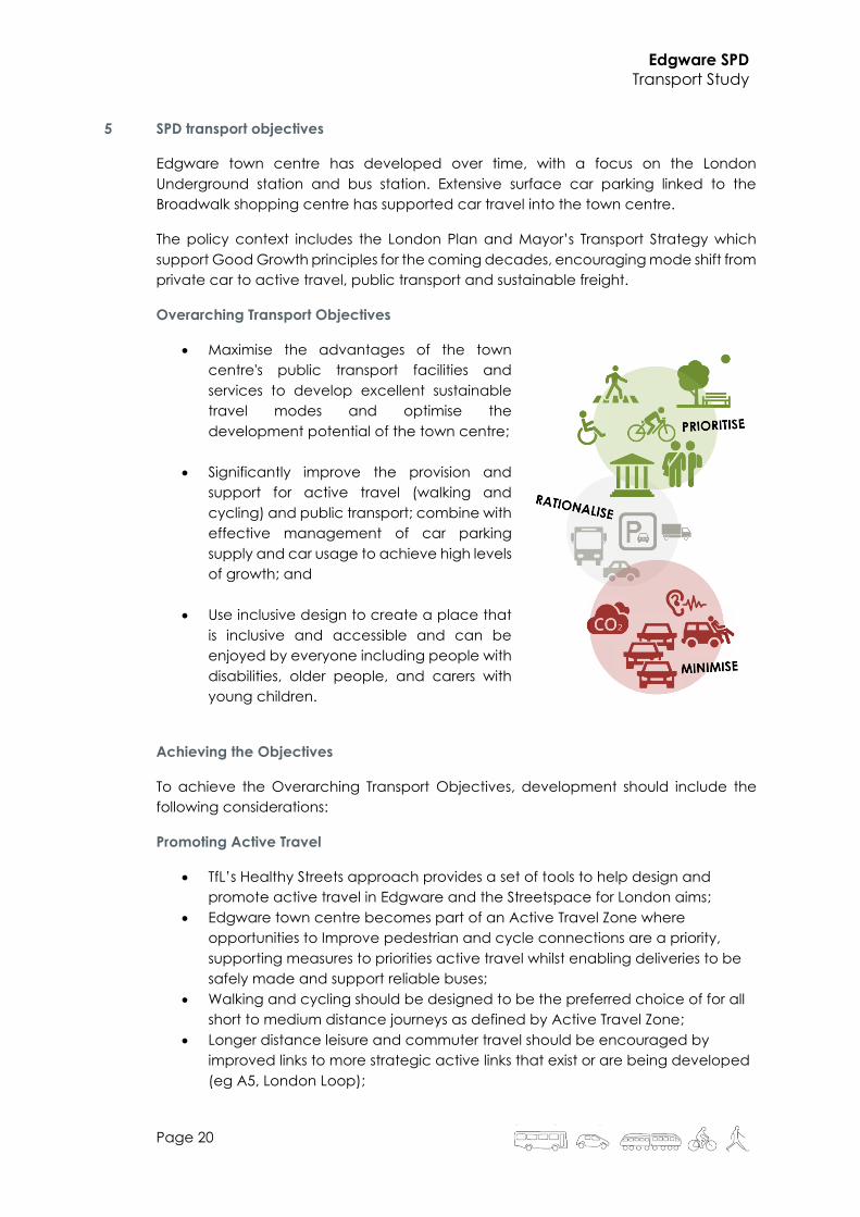
Overarching Transport Objectives
• Maximise the advantages of the town
centre's public transport facilities and
services to develop excellent sustainable
travel modes and optimise the
development potential of the town centre;
• Significantly improve the provision and
support for active travel (walking and
cycling) and public transport; combine with
effective management of car parking
supply and car usage to achieve high levels
of growth; and
• Use inclusive design to create a place that
is inclusive and accessible and can be
enjoyed by everyone including people with
disabilities, older people, and carers with
young children.
Achieving the Objectives
To achieve the Overarching Transport Objectives, development should include the
following considerations:
Promoting Active Travel
• TfL’s Healthy Streets approach provides a set of tools to help design and
promote active travel in Edgware and the Streetspace for London aims;
• Edgware town centre becomes part of an Active Travel Zone where
opportunities to Improve pedestrian and cycle connections are a priority,
supporting measures to priorities active travel whilst enabling deliveries to be
safely made and support reliable buses;
• Walking and cycling should be designed to be the preferred choice of for all
short to medium distance journeys as defined by Active Travel Zone;
• Longer distance leisure and commuter travel should be encouraged by
improved links to more strategic active links that exist or are being developed
(eg A5, London Loop);

Edgware SPD
Transport Study
Page 21
• The choice to walk and cycle should be an easy choice encouraged by
design and provision of facilities, by improvements to the quality of public
realm and public spaces that encourages people to walk/ cycle to, and use,
local services and shops;
• Development to be permeable and enable convenient and high-quality
cycle and pedestrian routes from the development area that link into wider
desire lines;
• Public realm design to support walk and cycle links and provide for meeting
areas and seating;
• Boost health and well-being of local community through contributing to air
quality improvements and lower noise levels;
• Promote a safer and more secure environment for all road users including
pedestrians and cyclists;
• Cycle parking designed in accord with London Cycle Design Standards,
provision of a cycle hub and provision within the public realm;
Public Transport Accessibility, Legibility and Capacity
• Station capacity that enables that allows people of varying levels of mobility
to use the station;
• Protect line capacity to support growth in Edgware and along this branch of
the Northern Line, including depot space and rail sidings;
• Support bus reliability and access by safeguarding space for bus
operations/standing and also improving the public realm of the bus station
itself;
• Edgware bus station must :
1. Maintain a central location and enable easy interchange;
2. Overcome the severance caused by bus access on to Station Road and
reduce conflict with pedestrians accessing the station and its immediate
surroundings;
3. Provide intuitive way finding;
4. Offer high quality passenger information and waiting facilities;
5. Ensure integration of the station with its surrounding context.
• Interchange between bus and London Underground services is and will
remain important. The guiding principle is to improve passenger experience
by finding the balance between space, legibility/ visibility and proximity
between modes;
• Make the most of transport heritage and architecture to help promote local
identity and sense of place, particularly the London Underground station and
design heritage;
• Land uses in Edgware Town Centre must be planned and designed to ensure
that public transport uses (bus garage; bus station and stand; rail station,
sidings and depot) remain viable and can continue or grow without
unreasonable restrictions being placed on them (ie in line with the Agent of
Change principle - transport services operate around the clock and
throughout the year);

Edgware SPD
Transport Study
Page 22
Delivery, servicing and vehicle access
• Car free development is the starting point for all development in Edgware
given the well-connected nature of the area;
• Accessible car parking (Blue Badge) will be needed for future users and
residents of the town centre;
• Where vehicle access and car parking is provided this should be designed to
ensure access is safe and contribute to mode shift and reduce dependency
on car use;
• Where car parking is provided this should provide Electric Vehicle Charging
Points;
• Where there is a conflict between vehicle access points, especially Heavy
Good Vehicle routes, and pedestrian and cycle route, a risk assessment will
be required to inform any mitigation strategy; and
• Development servicing, deliveries and refuse collection will operate on the
basis of comprehensive delivery consolidation to minimise vehicle movements
to and within the development area.
Summary
These objectives have directly informed the proposed mitigation and wider
improvement measures that the SPD should deliver – see Chapter 8 for more detail.
In particular, relevant data and forecasting should be central to understanding the
impact of specific masterplan-based development proposals and how the proposed
measures.
Edgware SPD
Transport Study
Page 23
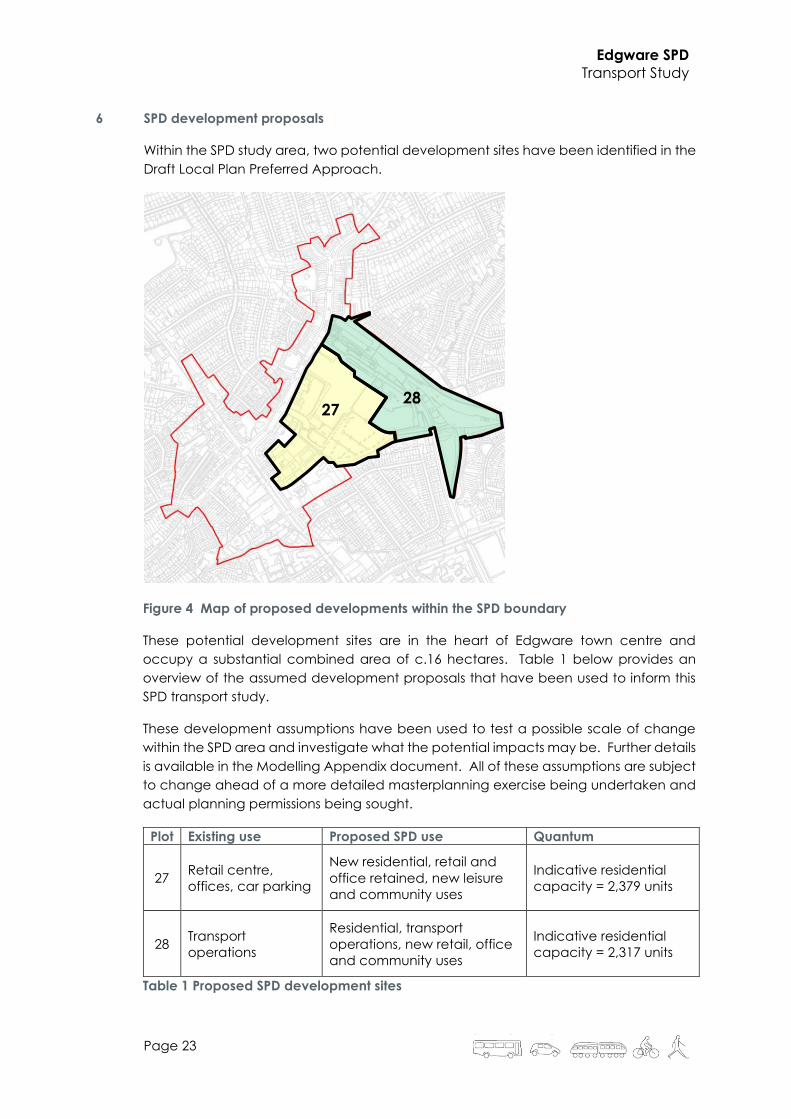
6 SPD development proposals
Within the SPD study area, two potential development sites have been identified in the
Draft Local Plan Preferred Approach.
Figure 4 Map of proposed developments within the SPD boundary
These potential development sites are in the heart of Edgware town centre and
occupy a substantial combined area of c.16 hectares. Table 1 below provides an
overview of the assumed development proposals that have been used to inform this
SPD transport study.
These development assumptions have been used to test a possible scale of change
within the SPD area and investigate what the potential impacts may be. Further details
is available in the Modelling Appendix document. All of these assumptions are subject
to change ahead of a more detailed masterplanning exercise being undertaken and
actual planning permissions being sought.
Plot Existing use Proposed SPD use Quantum
27 Retail centre,
offices, car parking
New residential, retail and
office retained, new leisure
and community uses
Indicative residential
capacity = 2,379 units
28 Transport
operations
Residential, transport
operations, new retail, office
and community uses
Indicative residential
capacity = 2,317 units
Table 1 Proposed SPD development sites
27 28

Edgware SPD
Transport Study
Page 24
Access and movement framework
Further to the SPD, detailed master planning work will be undertaken. This master
planning process will include the preparation of an access and movement framework
for the area which will include an assessment of appropriate walking, cycling and
vehicle links.
Reflecting the identified existing issues and constraints, policy summary and
overarching objectives, for the purposes of the transport study it has been assumed:
• Existing walk connections (eg Brook Avenue to West Way) will be retained and
upgraded to accommodate walking and cycling;
• Additional walking and cycling connections will be introduced where required to
deliver needed improvements in sustainable movement connectivity (eg to the
High Street via Forumside);
• A crossing over the existing tube lines may be needed to provide alternative
emergency access – this is in order to avoid long cul-de-sacs and provide rapid
access to the entire development area;
• The existing bridge over the tube lines will be available for walking and cycling –
leading to a substantial reduction in walking/cycling distances to the town centre
and a step-change improvement in public transport accessibility (PTAL 1 to PTAL 5);
and
• There will not be a new vehicular route through the development that would
provide a new strategic connection between, for example, Station Road and
Deans Lane.
Figure 5 Schematic access and movement plan

Edgware SPD
Transport Study
Page 25
Other town centre development sites
Information has been supplied by LB Barnet officers regarding other, relevant Edgware
town centre developments. A summary is provided in Table 2 below.
Location Development summary Testing assumptions
120-124 Station Rd
(Premier Place)
122 flats
1,855m2 A-class space
All retail trips linked to existing town
centre activity
Residential trip generation in the
order of 130 vehicle trips per day
Railway Hotel,
Station Road
90-bed hotel
(with 31 parking spaces)
No Transport Assessment prepared
in support of the planning
application
Total trip generation assumed to
be c.60 vehicles per day (each
parking space used for an inbound
+ outbound trip)
Rectory Grove,
Rectory Lane
52 residential units
Residential trip generation in the
order of 90 vehicle trips per day
Premier Inn, 435
Burnt Oak
Broadway
43 additional hotel rooms Total trip generation assumed to
be c.95 vehicles per day
Table 2 Other town centre development assumptions
Combining these four developments gives a total additional vehicle trip generation of
c.365 vehicle movements per day (inbound and outbound). This is equivalent to
approximately 40 two-way vehicle movements in a peak hour.
In addition, there will be additional movement on foot, cycle and public transport.
However, compared to existing volumes of movement by mode (see the baseline
appendix for more information), the scale of this additional movement for the
combined developments will not lead to conditions significantly different from the
present day.

Edgware SPD
Transport Study
Page 26
Figure 6 Location of other town centre developments
Wider growth
Barnet is expected to deliver a minimum of 46,000 new homes within the lifetime of its
new Local Plan (2021-2036). This represents a substantial increase in the resident
population in the Borough; the indicative residential capacity of the sites within
Edgware of 4,600 units represents 10% of this total.
Strategic modelling of the impacts of Local Plan growth is expected to be undertaken
as the Local Plan progresses to the Regulation 19 stage. Testing of the growth proposed
in this SPD will be considered within the overall context of this Local Plan testing and
analysis.
The Draft Local Plan states that “These [town centre development and enhancement]
proposals should be informed by the outputs of an area wide transport model.” [para
11.5.9]
In light of this forthcoming, overarching Local Plan testing, this SPD transport study will
consider mores local-scale highway issues relating to local congestion, etc. The
primary aim being to: (a) ensure local conditions are not adversely affected; and (b)
establish how to facilitate wider transport/behaviour change through SPD
development.
Regeneration of the town centre will play a leading role in bringing about
transformational modal shift - a catalyst for walking and cycling growth, bus
Rectory Grove
Premier Place
Station Hotel
Premier Inn

Edgware SPD
Transport Study
Page 27
improvements and the strong promotion and normalisation of movement by non-car
modes.
This is fully consistent with, and a key driver of, a longer-term shift in Barnet’s sustainable
mode share from 59% today to 72% in 2041, set against the Mayor’s Transport Strategy’s
overarching objective for 80% of all trips in London to be on foot, by cycle or public
transport.
Retail, leisure and cinema catchment analysis
Use has been made of the ‘Town Centres Floorspace Needs Assessment’ undertaken
for Barnet Council in December 2017. It was an assessment of retail need for the
Borough in order to inform new retail and town centre policies for the Local Plan.
The study found that Edgware town centre’s core catchment area is solely confined
to the local area. Edgware residents otherwise travel to a broad range of
destinations to undertake retail activity.
More recently, an Edgware Town Centre Economic Strategy2 has been produced that
considers emerging trends in town centre development. The study also includes a
baseline review of Edgware town centre’s composition and identifies gaps in current
provision.
In summary, the study concludes that: “By strengthening specific commercial aspects
of the town centres composition (comparison retail, food and beverage, commercial
leisure and employment uses), seeking opportunities for features which will attract and
differentiate the town centre (such as cultural and art offerings) and providing
environmental improvements including usable public spaces Edgware town centre
should ensure its ongoing vitality and viability.”
As a proxy for the future development and widening of Edgware town centre’s offer,
desktop reviews of available leisure centre and cinema options in the wider area has
been undertaken with ‘gravity’ models developed to understand the likely demand
each of these uses has by existing (and new) Edgware residents.
The models also assessed the impact of introducing new facilities in the town centre.
For both leisure centre and cinema uses, it could be expected that new facilities would
attract a significant proportion of demand.
Overall, in this high-level transport study is assumed that a strengthened and
revitalised town centre ‘offer’ with a wider range of retail, food & drink and leisure
options will:
a) Provide more opportunities for local residents (existing and new) to have their
retail/leisure needs met locally without the need to travel to other centres; and
b) Strengthen the town centre’s reach / market share in the wider area and
capture activity that is currently going to/from other centres further afield.
2 Edgware Town Centre Economic Strategy, Transport for London, August 2020

Edgware SPD
Transport Study
Page 28
7 SPD development impact assessment – assumptions, methodology and summary
This section provides an overview of the technical analysis undertaken to test the likely
impact of the proposed SPD developments. More detail is provided in the ‘modelling
appendix’ at the end of this document.
This high-level transport study assumes a high-intensity scenario whereby the
anticipated maximum residential capacity of c.4,600 units will be delivered in some
form across both sites identified in the Draft Local Plan.
For non-residential uses the following high-level assumptions have been made:
• retail retained at its existing quantum;
• office retained at its existing quantum;
• increase in bus garage land take required for electrification; and
• new leisure uses including cinema and swimming pool.
It has been assumed that any new primary school provision that is required to
support SPD development will be close walking (and scooting) distance. This will ensure
sustainable travel modes are the dominant, obvious choice for parents and children.
High-quality walking and cycling links should be provided through/around the SPD
area to facilitate safe and efficient movement to/from the school(s). For secondary
school provision it has been assumed that demand will be spread locally to nearby
schools, both within the Borough and in Harrow.
The location and layout of this mix of retained and new uses will not be specifically
addressed; their cumulative impact and ability to deliver on a widened, strengthened
town centre offer will be the main focus. This is also considered below under
‘internalisation’.
The modelling approach has followed a conventional four-stage modelling approach:
Trip Generation > Trip Distribution > Trip Mode > Trip Assignment
Each stage has been informed by robust, appropriate data and assumptions,
appropriate for this high-level study.
Trip generation has been assessed using a combination of benchmark data from the
TRICS database combined with journey purpose data taken from the National Travel
Survey.
Trip distributions have been informed by Census Journey to Work data, future
assumptions on home / close-to-home working, educational provision, and
leisure/other purpose trip making – including internalisation within Edgware town
centre, reflecting its strengthened daytime and evening offer.
Trip mode shares have also been informed by Census Journey to Work data, an
assessment of existing/future public transport options, car parking provision (SPD and
wider town centre) and future assumptions for propensity to travel by active modes –
using TfL’s ‘Transport Classification for Londoners’ segmentation analysis. They are also
consistent with the vision statements in the LTTS relating to short, medium and longer-
distance trips.

Edgware SPD
Transport Study
Page 29
Commentary
Overall, the SPD development assumptions give rise to a substantial volume of trips
across the day and in peak hours:
• Approximately 39,000 trips per day (by all modes; inbound and outbound)
• There is a clear morning peak that is dominated by work and education trips –
approximately 3,500 in total;
• There is a mid-afternoon peak that is created by school departures; and
• There is an evening peak spread over several hours (4-7pm) that comprises a
mix of work, leisure and personal journey purposes.
This scale of movement is a ‘game changer’ and needs to be matched by a scale of
ambition that makes significant, positive interventions to accommodate this change.
The significant proportion of trips taking place by active (walk/cycle) and sustainable
(bus, tube) modes will need to carefully considered in terms of design, management
and desired travel behavioural outcomes.
In line with aspirations in the Draft Local Plan, it is assumed that the pattern of future
employment demand will see greater local and intra-Borough opportunities, notably
growth at Brent Cross. It is also anticipated that there will be continued, strong growth
in working from home and/or remote working using hubs close to home locations. This
trend could be magnified by longer-term responses to the COVID-19 pandemic.
Leisure and personal trips have been assumed to be a wide mix of very local through
to London-wide distance trips. Edgware’s existing town centre ‘offer’ will be
significantly strengthened by SPD development leading to increased numbers of trips
being made within a short, walkable distance of the town centre. This ‘internalisation’
is a key expectation of the proposed SPD development and one that will deliver a
step change in how the town centre functions through the day, including a greater
emphasis on expanding the evening economy.
Based on the prevailing policy context (both London-wide, GLA’s London Plan and
locally, Barnet’s Draft Local Plan) the assumed starting point for new
development in Edgware town centre is for it to be car free.
The vast majority of trips will be undertaken by sustainable modes, particularly walking
and cycling. Dependent on journey distance, different mode (or modes) of travel will
be more feasible / attractive than others.
Work trips primarily take place by public transport – with a broadly equal split between
tube and bus use. This reflects the relatively equal split between destinations that can
/ can’t be made by tube. However because of the wide distribution of workplaces in
outer London (and beyond) that are not necessarily well served by public transport
there is a modest car mode split – reflecting a mix of private vehicles, privately-hired
vehicles and other future car-based mobility options.
The overwhelming majority of education purpose trips are by walking with a smaller
component by cycle, bus and other modes reflecting the wider secondary school
catchments.
Edgware SPD
Transport Study
Page 30
Personal and leisure purpose trips are biased towards active travel modes with
sustainable modes (bus, tube) making up the majority of the remainder of travel
demand. A small proportion of trips are being made by vehicles – again reflecting a
mix of private vehicles, privately-hired vehicles and other future car-based mobility
options.
Impact assessment – bus
SPD development-generated bus demand in the AM and PM peak hours is equivalent
to an additional c.800 passengers per hour (inbound and outbound). This demand will
be highest nearest to Edgware town centre (wider, borough and strategic zoning)
and will reduce as buses travel further away.
During peak periods, the 14 bus routes covering Edgware (both starting/terminating
at the bus station and through routes) provide a combined peak service frequency
of 175 buses per hour. Spread equally across all services, the SPD development
demand is equivalent to a modest additional 4 passengers per service per hour.
Baseline bus usage data (TfL’s BODS dataset) indicates that, when all services are
combined throughout the day, on average each bus operates at a relatively low level
of utilisation, equivalent to c.30% of its total standing capacity. The addition of the all-
day SPD development demand is equivalent to an additional 4% of total standing
capacity. As such, in principle there would appear to be sufficient capacity to
accommodate the estimated additional patronage generated by the SPD
development.
Allowing for peak hour loadings well in excess of the daily average reported in BODS,
indicative peak period utilisations by service could range from 30% to greater than 80%
of total standing capacity. Within a particular peak period, the busiest buses could
experience higher utilisations still. Given this range of peak period utilisations, the
addition of the SPD development demand could be expected to be accommodated
on many but not necessarily all services when they are operating at their busiest times.
The indicative scale of additional bus demand (switching from other modes, notably
car) that is generated by town centre improvements and wider travel behaviour
changes might be expected to be in the order of 1,500 people per day. This is smaller
in scale than the SPD-generated demand above and, as such, could also be expected
to be accommodated on many but not necessarily all services when they are
operating at their busiest times.
In the longer-term, TfL has forecast that to reach the targeted 80% mode share for
sustainable modes, a 40% increase in bus passengers will be required across London,
and higher in outer Boroughs where current bus use is lower. Therefore it can be
expected that there will be large increases in bus patronage over and above that
generated by the SPD development which will need to be planned for and
accommodated.
Bus service improvements, both in terms of frequencies and areas covered, should
be investigated to meet agreed, identified future shortfalls. This includes exploring
future opportunities for new routes including potential BRT (bus rapid transit) alignments
to Mill Hill East, using the proposals in the LTTS as a starting point.

Edgware SPD
Transport Study
Page 31
Impact assessment – tube
Total inbound / outbound tube flows are in the range of 7,500 – 8,000 per day with a
peak flow of between c. 1,200 inbound (PM, 6-7pm) and c.1,400 outbound (AM, 8-
9am).
Comparing this estimated SPD travel demand with existing station entry/exit flows taken
from TfL’s RODS dataset gives a c.33% increase across the day (6am-9pm). Peak
increases in station flows are +54% exits (9-10am) and +69% entries (7-8pm).
Static analysis of the existing station gate line indicates that there should be sufficient
capacity to accommodate the SPD development-generated additional tube
demand.
In terms of train loadings, the SPD development generates a maximum additional
loading of 20 passengers per train per hour (AM, 8-9am) and 17 passengers per hour
(PM, 5- 6pm). Loadings decrease as distance increases away from Edgware.
Maximum train loadings are seen in the AM peak southbound (185% of seated
capacity / 105% of standing capacity) and in the PM peak northbound (143% of seated
capacity / 81% of standing capacity). This indicates that the estimated additional
demand generated by the SPD development can be accommodated, albeit
beyond the seated capacity of the train, at most times of the day - but not during the
AM peak southbound.
The SPD development-generated increase in pressure on the Northern line will need
to be considered further in conjunction with future patronage forecasts reflecting
increased demand from other major, strategic developments, any longer- term
impacts due to COVID-19, and opportunities for increasing peak period capacity.
Impact assessment – highway
Surveyed, existing car park flows (long stay and short stay) are in the order of 7,200
vehicle movements per day (inbound and outbound). This comprises long-stay car
parking that sees 100% utilisation and short-stay car parking that sees a maximum
utilisation in the order of 60%.
The under-utilisation of the short-stay car parking supply combined with the clear future
policy imperative for reduced car use (notably the Mayor’s 2041 target of 72%
sustainable travel mode share) means that a reduced town centre car parking supply
should be a clear goal for the SPD, combined with supporting measures to enable,
promote and encourage increased movement by walking, cycling and public
transport.
The loss of long-stay parking (primarily used for onward tube travel towards central
London) is expected to lead to a several responses: relocated parking activity within
Edgware; a changed mode of travel to the tube station (ie car to non-car modes);
and changed tube station use (ie drive to another location with parking availability).
In terms of any locally-relocated parking activity, a review of (and possible expansion
of) existing CPZ schemes would be required to ensure no unwanted overspill parking
impacts arise from the removal of this long-stay parking supply.

Edgware SPD
Transport Study
Page 32
The existing off-street car park flows are of a similar order of magnitude to the future
vehicle trip generation from the SPD developments – a combination of residential uses,
retained retail activity (albeit with a reduced and intensified car park – 500 spaces
at 90% maximum utilisation), and new leisure and cinema uses.
The overall all-day movement change by vehicle could be expected to be modest, in
the order of approximately 280 additional inbound and outbound vehicle movements.
The balance of movement by hour will vary due to changes in parking type
(removal of long-stay commuter parking) and new residential journey purposes.
Overall, the scale of change in any one hour is +/- 100 vehicles per hour.
Existing flows all directed through a single access point on Station Road. Future flows
should be split, if possible, across several points of access (onto Station Road,
possibly onto the High Street via Forumside, and possibly to the east onto Deans
Lane). Splitting the SPD development across several access junctions could be
expected to lead to an overall net reduction in junction flows at the main Station Road
access point.
When spread more widely across the local highway network (eg High Street north
and south, Whitchurch Lane, Hale Lane, Edgwarebury Lane, Deans Lane) the total
net change in vehicle movement that could be expected by SPD development is
modest (far right columns of Table 31) and in principle could be accommodated,
subject to more detailed analysis at masterplanning stage once site capacities and
site accesses are known.
There is a clear opportunity to provide a quantum of off-street parking below the
assumed 500 spaces to lower, longer-term levels in order to (a) directly influence travel
behaviour and (b) reflect anticipated decreases in car use. As such, a reduced
quantum of off-street parking should be the overall aspiration of the SPD development
and one which could lead to further reductions in highway network flows.
More widely, the clear policy imperative for London more generally and for Barnet
and Edgware more specifically is for substantially increased levels of walking, cycling
and public transport use and consequent reductions in car use – noting the longer-
term target of 72% of Borough trips being made by sustainable modes of travel by
2041 (set against a London-wide target of 80% of trips). This shift is entirely consistent
with the SPD development principles and modelling assumptions.
In principle, a shift from car to sustainable modes could therefore be expected to
lead to reductions in traffic levels throughout Edgware town centre. This, combined
with a ‘net no change’ SPD development impact suggests that a future highway
network could (a) accommodate predicted demand and (b) be optimised in key
locations to provide additional space, priority and infrastructure for walking and
cycling activity. Indeed, clearly prioritising walking and cycling movement within the
town centre will be critical to delivering the ambitious SPD principles.
The volume of active travel (walking and cycling) movement generated by the
proposed SPD development (see below) is significant and will require specific measures
such as additional pedestrian crossings. As development proposals become more

Edgware SPD
Transport Study
Page 33
refined the impact of such measures will need to be considered to understand any
changes to highway capacity, reassignment to other routes and any resulting impacts.
Impact assessment – walk and cycle
The scale of walking and cycling movement generated by the proposed SPD
development is considerable, in the order of 20,000 walking trips per day / 3,000 trips
per hour and 3,500 cycling trips per day.
Compared to observed flows of 500 walking trips per hour along Station Road this
represents at least a five-fold increase in walking activity; for cycling there is an even
larger increase on the low existing, observed flows.
The vast majority of walking activity will take place within a very short distance,
contained within the town centre. For cycling activity, journey distances extend to
the wider local and Borough areas.
This scale of change suggests considerable improvement is needed in terms of
provision for active modes. A comprehensive package of measures to radically
improve the public realm in the town centre is proposed (see next Chapter, SPD
transport measures).
Edgware SPD
Transport Study
Page 34
8 SPD transport measures
The assessed impacts of the proposed SPD development have been mapped out
against the overarching transport objectives identified in Chapter 5. From this, a
package of SPD transport measures have been developed to:
• Address existing weaknesses in the SPD area;
• Pursue opportunities for positive change; and
• Respond to changes arising from SPD development.
These measures/initiatives are presented by mode below. Where applicable,
measures are cross-referenced in square brackets against those included in the LTTS
(see also Figure 10).
For many of the measures below an important consideration is to have as seamless a
transition as possible between the two boroughs (Harrow to the west of A5 High Street,
Edgware to the east). For example, speed limits through the town centre should cover
both Harrow and Barnet and any new bus and cycle infrastructure should be
continuous through the Station Road / High Street / Whitchurch Lane junction. Similarly
servicing arrangements and parking controls should be similar between both boroughs.
Walking and cycling
• Use TfL’s Healthy Streets approach (including Healthy Streets Toolkit) to help
design and promote active measures;
• Specifically, make Edgware town centre part of an Active Travel Zone where
opportunities to improve pedestrian and cycle connections are a priority –
linking also to the LTTS proposal for ‘low traffic neighbourhoods’ [LTTS W2];
• Provide direct, well-signed and high-quality pedestrian links
through the town centre that connect existing residential areas
and new development. Improve legibility [LTTS W3] and reduce
barriers and severance caused particularly by the tube lines
and sidings;
• Improve pedestrian crossing provision, including at the Station Road / High
Street junction, along Station Road, at a new Station Road / SPD site access
junction and towards the east of the SPD area at the junction of Hale Lane and
Edgwarebury Lane;
• Promote contemporary street designs that are laid out more flexibly for
pedestrian, social and limited vehicular activity – and which are future-
proofed for changes in travel behaviours;
• Address actual and perceived personal security concerns – particularly along
links that are poorly lit with limited natural surveillance, eg links to/from Fairfield
Crescent;

Edgware SPD
Transport Study
Page 35
• Providing dedicated cycling infrastructure within the SPD and
surrounding area – a mix of on-street and off-street depending on
local context and opportunities. Specific opportunities include a
step-change in the provision and quality of cycle facilities along
the A5 High Street / Edgware Road corridor[LTTS C1];
• New cycle parking, including the provision of a cycle hub within the public
realm, to be designed in accordance with London Cycle Design Standards
[LTTS C2];
• Include electric charging points on cycle racks;
• Promote behaviour change based on Transport Classification of Londoners
profiles (see baseline appendix); and
• Actively encourage sustainable travel by residents, workers and visitors through
a comprehensive package of ‘Travel Planning’ measures and interventions –
including creation of ‘school streets’ [LTTS W1].
Traffic Management
• Car-free development will be the starting point for all
development in Edgware given the well-connected nature of
the area;
• Reduce peak time queueing on Station Road and other key town centre links
through better traffic management and managing demand more widely
across the area;
• Introduce speed-reduction measures to stop rat-running on residential streets
– eg local or area-wide 20mph zone and/or ‘slow streets’ (less than 12 mph)
where pedestrian flows are highest [LTTS R3];
• Reduce vehicle domination of streets and roads through safety and public
realm improvements to ensure the Mayor’s Vision Zero targets are met;
• Address identified road safety issues, focussing on ‘hotspot’ locations such as
the Station Road / High Street junction – with clear linkages to other
walking/cycling improvements;
• Where there is a conflict between vehicle access points, especially Heavy
Goods Vehicle routes, and pedestrian and cycle route, a risk assessment will
be required to inform any mitigation strategy; and
• Focussed local management on areas immediately surrounding schools –
notably Edgware Primary School.

Edgware SPD
Transport Study
Page 36
Deliveries and Servicing
• Rationalise distribution and deliveries to ease congestion along
Station Road and High Street;
• Carefully design new development to ensure deliveries and
servicing takes place off-street and operate comprehensive delivery
consolidation measures to minimise vehicle movements to and within the
development area [LTTS F2]; and
• Make use of the evening and night-time to undertake delivery activity – lower
levels of vehicle activity and reduced conflict with pedestrians and cyclists.
Buses
• Explore measures to reduce conflict between existing bus
station access and other town centre users – using a risk-based
approach in line with Vision Zero;
• Bus service improvements, both in terms of frequencies and areas covered,
should be investigated to meet agreed, identified future shortfalls – including
exploring options for BRT (bus rapid transit) to Mill Hill East, subject to identifying
a feasible crossing over the Northern Line [LTTS PT1];
• Investigate the rationalisation of services along Station Road to reduce bus
congestion through improved efficiency and effectiveness;
• Support bus reliability [LTTS PT2] and access by safeguarding space for future
bus operations/standing and also improving the public realm of the bus
station itself [LTTS PT4];
• Provide for a larger bus garaging solution that accommodates electrification
requirements and capacity for future SPD and wider growth;
• When developing proposals for a relocated bus station, apply the following
principles:
1. Maintain a central location and enable easy interchange;
2. Overcome the severance caused by bus access on to Station Road and
reduce conflict with pedestrians accessing the station and its immediate
surroundings;
3. Provide intuitive way finding;
4. Offer high quality passenger information and waiting facilities;
5. Ensure integration of the station with its surrounding context;
• Investigate introducing on-demand bus services (demand responsive
transport, DRT) that operates flexibly in response to local demand in the wider
Edgware area that is currently poorly served by public transport [LTTS PT3]; and

Edgware SPD
Transport Study
Page 37
• Ensure bus stops outside of the station complex meeting high standards of
accessibility, shelter, etc and provide sufficient kerb space (length and
footway width) for the levels of bus services forecast.
Tube
• Investigate need for station entry/exit improvements – linked to
public realm treatment along Station Road;
• Ensure sufficient station capacity that enables people of varying
levels of mobility to use the station;
• Protect line capacity to support growth in Edgware and along this branch of
the Northern Line, including depot space and rail sidings; and
• Promote a high-quality interchange between bus and London Underground
services – focussing on providing legibility/visibility and proximity between
modes.
Parking
• Manage on-street car-parking with phased, longer-term reductions
over time – taking opportunities to release space currently used for
on-street parking and deliver public realm gains;
• Review / expand existing CPZ schemes to ensure car-free development is
achieved and to protect local amenity;
• Maximise utilisation of off-street parking throughout the day, including
evenings by managing actively different land use demands [LTTS R5];
• Introduce car-share clubs – with well-located spaces near to key destinations
and generators of trips [LTTS R1];
• Accessible car parking (Blue Badge) will be needed for future users and
residents of the town centre and should be provided in line with London Plan
standards; and
• Electric vehicle charging points to be provided in line with London Plan
standards [LTTS R2] and future proof streets with passive electric feeds.
Public Realm
• Focus public realm improvements on the Station Road and A5
High Street / Edgware Road corridors – reflecting substantial
predicted increases in pedestrian footfall and activity –
widened footways (where space permits), improved surfacing,
new seating; and
Edgware SPD
Transport Study
Page 38
• Create new public spaces that are inclusive and accessible and enjoyed by
residents, workers, visitors and the local community – delivered in part through
development-specific planning applications.
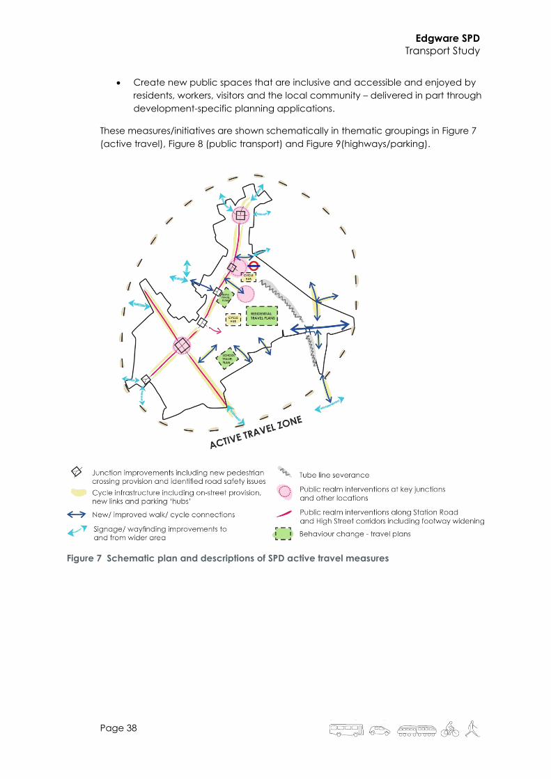
These measures/initiatives are shown schematically in thematic groupings in Figure 7
(active travel), Figure 8 (public transport) and Figure 9(highways/parking).
Figure 7 Schematic plan and descriptions of SPD active travel measures

Edgware SPD
Transport Study
Page 39
Figure 8 Schematic plan and descriptions of SPD public transport measures

Edgware SPD
Transport Study
Page 40
Figure 9 Schematic plan and descriptions of SPD highways measures
These measures and initiatives are consistent with those identified, at a higher level,
within the Draft Barnet Long-term Transport Strategy (see also Figure 11):
• Northern line upgrade;
• Express and orbital bus routes;
• Town centre legibility improvements;
• Low traffic neighbourhoods (to the north of the town centre);
• Strengthened local cycle network; and
• School streets (several locations within the SPD area).

Edgware SPD
Transport Study
Page 41
Figure 10 Proposals for the SPD area [extracted from the 2019 Draft Barnet Long-term
Transport Strategy]

Edgware SPD
Transport Study
Page 42
9 Delivery and Timescales
By taking a flexible approach to the delivery of the measures there is scope to
maximise their benefits. An indicative prioritisation of measures is shown in
Table 5 which will help ensure that each initiative is rolled out at the appropriate
time and in the most beneficial way.
On-going effort is required to evaluate and sustain the success of the SPD. This
can be achieved through setting targets and systematic monitoring against
them, including the delivery of these, and other, measures.
Indicative time horizons are:
• Quick win = up to 5 years;
• Medium-term = 5 to 10 years; and
• Longer-term = 10+ years.

Edgware SPD
Transport Study
Page 43
Table 5 Indicative prioritisation of SPD transport measures
Theme MeasureQuick
win
Medium
term
Longer
term
Walking and cycling Use TfL’s Healthy Streets approach ✓ ✓
Walking and cycling Active Travel Zone ✓ ✓
Walking Direct, well-signed and high-quality pedestrian links ✓ ✓ ✓
Walking Improve pedestrian crossing provision ✓ ✓ ✓
Walking Promote contemporary, flexible street designs ✓ ✓
Walking Address actual and perceived personal security concerns ✓ ✓ ✓
Cycling Provide dedicated cycling infrastructure ✓ ✓
Cycling Cycle parking (including electric charging) and cycle parking hubs ✓ ✓ ✓
Walking and cycling Promote behaviour change (Transport Classification of Londoners) ✓ ✓ ✓
Walking and cycling 'Travel Planning' measures and interventions. ✓ ✓ ✓
Traffic Management Car free development ✓ ✓
Traffic Management Reduce peak time queueing ✓ ✓
Traffic Management Introduce speed-reduction measures - 20mph zones and/or 'slow streets' ✓ ✓
Traffic Management Reduce vehicle domination of streets ✓ ✓ ✓
Traffic Management Address identified road safety isssues ✓ ✓ ✓
Traffic Management Modal conflict risk assessments (particularly goods vehicles) ✓ ✓
Traffic Management Focussed local management (eg schools) ✓ ✓
Deliveries and Servicing Rationalise existing deliveries/servicing ✓ ✓ ✓
Deliveries and Servicing Delivery consolidation measures ✓ ✓ ✓
Deliveries and Servicing Evening and night time deliveries ✓ ✓ ✓
Bus Reduce conflict between bus station and other users ✓ ✓
Bus Bus service improvements - including BRT options ✓ ✓
Bus Investigate rationalisation of services along Station Road ✓ ✓
Bus Safeguard space for future bus operations/standing ✓ ✓ ✓
Bus Provide for a larger bus garaging solution (incl. electrification requirements) ✓ ✓ ✓
Bus Develop proposals for a relocated bus station following detailed principles ✓ ✓
Bus Investigate introducing demand-responsive services ✓ ✓
Bus Improvements to bus stops across town centre ✓ ✓
Bus and Tube Promote a high-quality interchange between bus and LU ✓ ✓
Tube Investigate need for LU station entry/exit improvements ✓ ✓
Tube Ensure LU sufficient station capacity for all users ✓ ✓
Tube Protect line capacity to support growth (incl. depot and sidings) ✓ ✓ ✓
Parking Reduce off-street car-parking through a phased approach over time ✓ ✓ ✓
Parking Review / expand existing CPZ schemes ✓ ✓
Parking Maximise utilisation of off-street parking throughout the day ✓ ✓ ✓
Parking Introduce car-share clubs ✓ ✓ ✓
Parking Accessible (Blue Badge) car parking ✓ ✓ ✓
Parking Electric vehicle charging points ✓ ✓ ✓
Public Realm Focussed public realm improvements on the Station Road corridor ✓ ✓ ✓
Public Realm Create new public spaces that are inclusive and accessible ✓ ✓ ✓

Edgware SPD
Transport Study
Page 44
DOCUMENT CONTROL
Version Date Author Reviewer Comments
1.0 01/05/20 SA Draft content
1.1 07/05/20 SA Initial draft
1.2 15/05/20 SA Updated content
1.3 19/05/20 SA WIP draft to client for info
1.4 29/05/20 SA Revised draft
2.0 19/06/20 SA Updated content
2.1 26/06/20 SA JE Draft final version
2.2 13/07/20 SA JE Issued to client for review
2.3 11/09/20 SA JE Final
2.4 17/12/20 SA JE Minor changes to page 3