Embed Size (px)
Citation preview
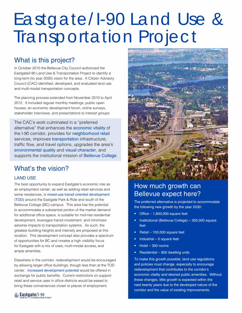
What is this project?In October 2010 the Bellevue City Council authorized the Eastgate/I-90 Land Use & Transportation Project to identify a long-term (to year 2030) vision for the area. A Citizen Advisory Council (CAC) identified, developed, and evaluated land use and multi-modal transportation concepts.
The planning process extended from November 2010 to April 2012. It included regular monthly meetings, public open houses, an economic development forum, online surveys, stakeholder interviews, and presentations to interest groups.
The CAC’s work culminated in a “preferred alternative” that enhances the economic vitality of the I-90 corridor, provides for neighborhood retail services, improves transportation infrastructure, traffic flow, and travel options, upgrades the area’s environmental quality and visual character, and supports the institutional mission of Bellevue College.
What’s the vision?Land UseThe best opportunity to expand Eastgate’s economic role as an employment center, as well as adding retail services and some residences, is mixed-use transit oriented development (TOd) around the Eastgate Park & Ride and south of the Bellevue College (BC) campus. This area has the potential to accommodate a substantial portion of the market demand for additional office space, is suitable for mid-rise residential development, leverages transit investment, and minimizes adverse impacts to transportation systems. As such, the greatest building heights and intensity are proposed at this location. This development concept also provides a spectrum of opportunities for BC and creates a high visibility focus for Eastgate with a mix of uses, multi-modal access, and ample amenities.
Elsewhere in the corridor, redevelopment would be encouraged by allowing larger office buildings, though less than at the TOD center. Increased development potential would be offered in exchange for public benefits. Current restrictions on support retail and service uses in office districts would be eased to bring these conveniences closer to places of employment,
Eastgate/I-90 Land Use & Transportation Project
How much growth can Bellevue expect here?The preferred alternative is projected to accommodate the following new growth by the year 2030:
· Office – 1,800,000 square feet
· Institutional (Bellevue College) – 350,000 square feet
· Retail – 100,000 square feet
· Industrial – 0 square feet
· Hotel – 300 rooms
· Residential – 800 dwelling units
To make this growth possible, land use regulations and policies must change, especially to encourage redevelopment that contributes to the corridor’s economic vitality and desired public amenities. Without these changes, little growth is expected within the next twenty years due to the developed nature of the corridor and the value of existing improvements.
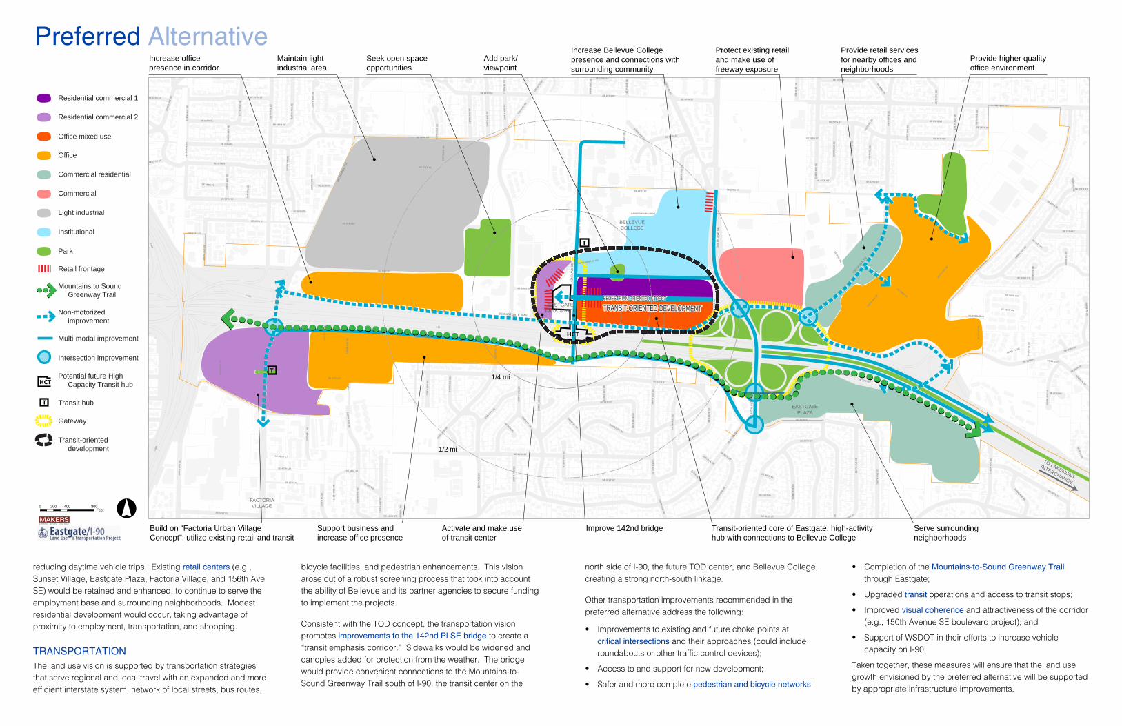
reducing daytime vehicle trips. Existing retail centers (e.g., Sunset Village, Eastgate Plaza, Factoria Village, and 156th Ave SE) would be retained and enhanced, to continue to serve the employment base and surrounding neighborhoods. Modest residential development would occur, taking advantage of proximity to employment, transportation, and shopping.
TRanspORTaTIOnThe land use vision is supported by transportation strategies that serve regional and local travel with an expanded and more efficient interstate system, network of local streets, bus routes,
bicycle facilities, and pedestrian enhancements. This vision arose out of a robust screening process that took into account the ability of Bellevue and its partner agencies to secure funding to implement the projects.
Consistent with the TOD concept, the transportation vision promotes improvements to the 142nd pl se bridge to create a “transit emphasis corridor.” Sidewalks would be widened and canopies added for protection from the weather. The bridge would provide convenient connections to the Mountains-to-Sound Greenway Trail south of I-90, the transit center on the
north side of I-90, the future TOD center, and Bellevue College, creating a strong north-south linkage.
Other transportation improvements recommended in the preferred alternative address the following:
· Improvements to existing and future choke points at critical intersections and their approaches (could include roundabouts or other traffic control devices);
· Access to and support for new development;
· Safer and more complete pedestrian and bicycle networks;
· Completion of the Mountains-to-sound Greenway Trail through Eastgate;
· Upgraded transit operations and access to transit stops;
· Improved visual coherence and attractiveness of the corridor (e.g., 150th Avenue SE boulevard project); and
· Support of WSDOT in their efforts to increase vehicle capacity on I-90.
Taken together, these measures will ensure that the land use growth envisioned by the preferred alternative will be supported by appropriate infrastructure improvements.
T
I-90
I-405
SE 36TH ST
SE EASTGATE WAY
SE 24TH ST
SE A
LLEN
RD
161S
T AVE SE
SE 32ND ST
150T
H A
VE S
E
139T
H A
VE S
E
RICH
ARDS
RD
SE 26TH ST
148T
H A
VE S
E
128T
H A
VE S
E
FAC
TOR
IA B
LVD
SE
124T
H A
VE S
E
SE 37TH ST
SE 26TH PL
SE 38TH ST
156T
H A
VE S
E
SE 30TH ST
SE 31ST ST
SE 41ST ST
EASTGATE DR
SE 35TH PL
160T
H AVE SE
140T
H A
VE S
E
154T
H A
VE S
E
136T
H P
L SE
142N
D P
L SE
SE 40TH ST
162N
D AVE SE
145TH PL SE
SE 41ST PL
SE 27TH ST
SE 25TH ST
146T
H A
VE S
E
151S
T AV
E SE
142N
D A
VE S
E
138T
H A
VE S
E 155T
H A
VE S
E
123R
D AV
E SE
SE 25TH PL
133R
D A
VE S
E
144T
H A
VE S
E
158T
H AVE SE
156T
H AVE SE
SE PERIMETER RD
129T
H P
L SE
145TH AVE SE
LANDERHOLM CIR SE
129T
H A
VE S
E
152N
D A
VE S
E
SE 28TH ST
134T
H A
VE S
E
SE 29TH ST
SE 23RD ST
138T
H PL SE
149T
H AV
E SE
162N
D P
L SE
130T
H A
VE S
E
SE 40TH LN
164TH PL SE
131S
T AV
E SE
139T
H PL
SE
132N
D A
VE S
E
SE 34TH ST
SE 40TH PL
SE 39TH ST
163R
D A
VE S
E
125T
H A
VE S
E
137T
H A
VE S
E
SE 33RD PL
127T
H A
VE S
E
SE 27TH PL
136T
H A
VE S
E
SE 40TH CT
SE 33RD ST
SE 30TH PL
135T
H P
L SE
SE 41ST LN
155T
H P
L SE
161S
T C
T SE
SE 22ND PL
146T
H P
L SE
126T
H A
VE S
E
SE 33RD LN
159T
H A
VE S
E
157T
H P
L SE
SE 28TH PL
135T
H A
VE S
E
SE 33RD CIR
143R
D A
VE S
E
151S
T PL
SE
161ST PL SE
SE 35TH CT
140T
H PL
SE
SE 35TH ST
SE 29TH PL
137T
H P
L SE
SE 39TH PL
127T
H P
L SE
157T
H A
VE S
E
163R
D P
L SE
SE 38TH PL
147TH PL SE
148TH PL SE
SE 24TH ST
SE 29TH PL
161S
T AV
E SE
SE 32ND ST
SE 26TH STSE 26TH ST
SE 25TH ST
SE 30TH ST
SE 41ST ST
SE 26TH ST
SE 37TH ST
155T
H A
VE S
E
139T
H A
VE S
E
SE 39TH ST
SE 37TH ST
128T
H A
VE S
E
I-405
138T
H A
VE S
E
148T
H A
VE S
E
SE 27TH ST
139T
H A
VE S
E
132ND
AVE SE
145T
H A
VE S
E
SE 25TH ST
SE 37TH ST
SE 31ST ST
136T
H A
VE S
E
126T
H A
VE S
E
SE 38TH ST
SE 25TH ST
146TH AVE SE
135T
H AVE SE
142N
D A
VE S
E
SE 24TH ST
SE 28TH PL
SE 40TH PL
143R
D A
VE S
E
SE 40TH ST
163RD
PL SE
162N
D P
L SE
SE 40TH ST
144T
H A
VE S
E
129T
H P
L SE
SE 37TH ST
SE 25TH PL
SE 41ST ST
129T
H A
VE S
E
124T
H A
VE S
E
SE 42ND ST
131S
T AV
E SE
SE 27TH ST
I-405
SE 27TH ST
134T
H A
VE S
E
SE 29TH ST
147TH AVE SE
SE 41ST PL
142ND PL SE
SE 41ST ST
155T
H PL
SE
126T
H A
VE S
E
140T
H A
VE S
E
SE 24TH ST
SE 28TH ST
153R
D A
VE S
E
146T
H A
VE S
E
130T
H A
VE S
E
SE 41ST PL
SE 25TH ST
147T
H A
VE S
E
SE 36TH ST
124T
H A
VE S
E
162ND AVE SE
142N
D A
VE S
E
139TH PL SE
SE 38TH ST
156T
H A
VE S
E
158T
H A
VE S
E
154T
H A
VE S
E
SE 27TH ST
SE 23RD ST
148T
H A
VE S
E
164TH PL SE
SE 28TH PL
Preferred Alternative
MAKERSarchitecture urban designplanning
°0 400 800200Feet
Residential commercial 1
Residential commercial 2
Office
Commercial residential
Commercial
Light industrial
Institutional
Park
Retail frontage
Mountains to Sound Greenway Trail
Non-motorized improvement
Multi-modal improvement
Gateway
Transit-oriented development
Transit hubT
Potential future High Capacity Transit hubHCT
Office mixed use
Intersection improvement
Support business and increase office presence
1/4 mi
1/2 mi
HCT
TO LAKEMONT
INTERCHANGE
BELLEVUECOLLEGE
FACTORIAVILLAGE
EASTGATEPLAZA
EASTGATEPARK & RIDE
PEDESTRIAN-ORIENTED STREET
TRANSIT-ORIENTED DEVELOPMENT
Seek open space opportunities
Maintain light industrial area
Add park/viewpoint
Provide higher quality office environment
Provide retail services for nearby offices and neighborhoods
Protect existing retail and make use of freeway exposure
Increase Bellevue College presence and connections with surrounding community
Increase office presence in corridor
Activate and make use of transit center
Improve 142nd bridgeBuild on “Factoria Urban Village Concept”; utilize existing retail and transit
Serve surrounding neighborhoods
Transit-oriented core of Eastgate; high-activity hub with connections to Bellevue College
T

Better visibility for new Bellevue College buildings
Direct pedestrian connector to center of Bellevue College campus
Retain greenbelt
Stairway with plazas
Residential mixed-use buildings away from the freeway
“Main Street” provides access and a pedestrian-oriented setting to new development
Structured parking -- parking requirements reduced to encourage transit ridership
Heavily landscaped SE Eastgate Way frontage
New development allowed up to 12 stories and apts 5.0 FAR with incentives
Access from 142nd AVE SE and transit flyover
High quality pedestrian-oriented streetscape
High capacity transit center
Modest amount of pedestrian-oriented commercial frontage near transit center
5’ wide bikeway on south side of SE Eastgate Way
Universally-accessible connection between 192nd Ave SE and transit center in an iconic structure
New bus stops
New bus stops
Widened and covered walkway across freeway
Pedestrian and bicycle connections to Mountain to Sound Greenway
What could it look and feel like?Building on Bellevue’s “City in a Park” theme, landscaping is emphasized to enhance corridors and frame views, such as naturalistic landscaping in the freeway and interchange ROW and substantial street landscaping on several streets. The new TOD area will likely be a more intense, urban character with a pedestrian-friendly main street and landmark structures visible from I-90 (see image above). Finally, the Mountains to Sound Greenway trail will add a “green” connector through the area.
How can it happen? The “vision” is just the starting point for realizing the evolution of the corridor. General implementation strategies include:
· Amend the City’s Comprehensive Plan, Land Use Code, Zoning Map, and Transportation Facilities Plan.
· Complete the environmental review.
· Balance increased development potential with public benefit requirements (e.g., open space, outdoor seating, affordable housing, bicycle facilities, etc.).
· Study allowable building heights and floor area ratios in more detail to ensure the quality of future development.
· Direct a substantial portion of the projected office and residential growth to the Transit-Oriented Development center through Land Use Code amendments.
· Partner or continue partnering with other agencies, service providers, and private development (e.g., WSDOT, Metro, Sound Transit, and Bellevue College).
· Invest in projects outlined in the Transportation Strategies Report.
· Create design guidelines and “green” guidelines to ensure high quality and sustainable private development.
· Landscape the interchanges with gateway treatments.
These actions will help ensure that the Eastgate corridor will continue be a major contributor to Bellevue’s economic vitality, provide local services and connections, serve as a prominent and visually pleasing gateway, and remain an attractive place in which to do business and serve the surrounding community.
Recommended improvements to SE 36th St include Mountains-to-Sound Greenway Trail on north side, landscaping to buffer walkers and bicyclists and encourage a human scale, prominent crosswalks, and striped bike route.
Vision for TOD area east of Park-and-Ride between I-90 and Bellevue College
For more information and full report, visit: www.ci.bellevue.wa.us/eastgate-corridor.htm