Embed Size (px)
Citation preview

138
3.1 Geophysical risk: earthquakesVitorSilva, Mauro Dolce, Laurentiu Danciu, Tiziana Rossetto,Graeme Weatherill
3.1.1Earthquake sources and seismotectonic
setting
3.1.1.1 Global distribution of
earthquakes
The global distribution of earth-quakes, as shown in Figure 3.1, is one of the key insights into the shape of the Earth’s lithospheric plates and their direction of movement. The vast majority of earthquakes are generated at boundaries, where plates converge, diverge or move laterally past one an-other (Bird 2003). The greatest pro-portion of seismicity, and by far the largest proportion of seismic energy release, occurs in regions where lith-ospheric plates converge with one an-other. These convergent boundaries may manifest as regions of subduc-tion, where an oceanic plate is forced beneath a less dense plate, that is, ei-ther a continental or a younger oce-
anic plate. In a convergent boundary between continental plates, tecton-ic compression may produce fold-ing and faulting and shortening and thickening of the plates within the collision zone (orogenesis or moun-tain building). The Himalaya Moun-tain Range is an example of this type of convergent boundary. Both types of regional environments are charac-terised by regions of high seismic ac-tivity and host faults that are capable of generating very large earthquakes. In Europe, convergence between the European and African plates mainly results in a large belt of compression in the western Mediterranean and subduction in the Calabrian, Hellenic and Cypriot arcs of the Central-East-ern Mediterranean.
Divergent plate boundaries represent areas where the shallow crust is be-ing pulled apart. These may manifest as rift zones, such as the East African Rift, where the shallow continental crust is undergoing extension, result-ing in moderate to high seismicity and volcanism. Earthquakes great-
er in magnitude than M7 are rare in such environments. Nonetheless, ex-tensional zones can be highly active and many areas, even those unrelated to divergent boundaries, such as the Apennines regions of central Italy or the Corinth Gulf, have seen repeated destructive earthquakes over the cen-turies. Transform and transcurrent plate boundaries manifest where the relative movement of plates is lateral.
Understanding past earthquakes and their
impact on society is the first step to assess
and eventually mitigate seismic risk.
This can be seen in several large active fault systems, such as the San Andre-as Fault (California), the North Ana-tolian Fault (Turkey) and the Dead

CHAPTER 3 UNDERSTANDING DISASTER RISK: HAZARD RELATED RISK ISSUES - SECTION I
139
Sea Transform Fault (Israel, Jordan). These active fault systems may ex-tend over many hundreds of kilo-metres and may experience frequent moderate-to-large earthquakes (M6 to M7.5). Owing to their proximity to many large urban centres, these sys-tems can pose a significant threat to society (e.g. Istanbul). While the vast majority of earthquakes tend to oc-cur in the regions of highest tectonic stress close to plate boundaries, tec-tonic earthquakes can occur within the lithospheric plates themselves. Intraplate regions are generally char-acterised by low rates of tectonic deformation, so the recurrence inter-vals between large events are typically
significantly longer (in the order of thousands to tens of thousands of years) than those of plate boundaries. Although large intraplate events are infrequent, they can produce strong-er shaking than their plate boundaries counterparts, and this is often felt over a larger area, as in the case of the 1811-12 New Madrid earthquakes in the east of the United States.
3.1.1.2 Past major earthquakes
From the time of the earliest civi-lisations to the advent of the era of instrumental recording, descriptions of earthquakes can be found in many
historical sources. Global archives of historical earthquakes include the United States National Geophysical Data Center (NGDC n.d.) and the Global Historical Earthquake Archive (Albini et al., 2014). A few historically relevant events are described herein.There have been reports of earth-quakes in the Mediterranean region, the Middle East, China and Japan since the fifth century BCE. Notable earthquakes in early civilisations in-clude the 464 BCE Sparta (Greece) event and the 227 BCE Dodecanese Islands event, the latter noted for its destruction of the lighthouse statue of the Colossus of Rhodes. As more historical sources survive from mid-
The global distribution of earthquakes in the period 1900 CE to 2014 CESource: Weatherill et al. (2016), Storchak et al. (2015) and global plate boundaries from Bird (2003)
FIGURE 3.1

140
to-late antiquity (300 CE to approxi-mately 750 CE), descriptions of the destruction caused by major events can help to determine the size and lo-cation of large earthquakes. Records exist of many catastrophic earth-quakes in the Mediterranean and Mid-dle East, including the 365 CE sub-duction earthquake in Crete, which had an estimated magnitude between M8.0 and M8.3. From 1000 CE to 1500 CE, many major earthquakes occurred in this region, including the 1457 Erzincan earthquake (estimated to have caused 32 000 deaths) and the 1202 Damascus earthquake (estimat-ed to have caused 30000 deaths).
The 16th to 18th centuries saw a con-siderable expansion of geographical
coverage of earthquake records, as settlements were established across the Americas and trade expanded between Europe and Asia. The 1556 Xian (China) earthquake (M≈8) is believed to be the most deadly on record, having caused an estimated 830 000 deaths (Bilham, 2004). Dur-ing the same period in Europe and the Middle East, two events stand out. The first is the 1509 Istanbul earthquake, which ruptured much of the North Anatolian Fault in the Sea of Marmara, resulting in thousands of deaths. The second is the 1755 Lisbon earthquake (M=8.5 ± 0.3, Martínez Solares and López Arroyo, 2004) and its accompanying tsunami. The devastation to the city of Lisbon, and to many towns along the Atlan-
tic coast of Portugal, Spain and Mo-rocco, contributed to between 60 000 and 100 000 deaths.
The 19th and 20th centuries marked the watershed between the era of historical observation and scientific investigation. Earthquakes such as those of 1906 in San Francisco, USA (M7.8), 1908 in Messina, Italy (M7.2), and 1923 in Kanto, Japan (M7.9), formed the catalyst for innovations in seismic design in these countries. From the second half of the 20th century to the present day, we have witnessed some of the largest earth-quakes recorded, including those of 1960 in Valdivia, Chile (M9.4), 2004 in Banda Aceh, Indonesia (M9.1), and 2011 in Tohoku, Japan (M9.0), with
Seismic recording stations with data contributing to the ISC.Source: authors
FIGURE 3.2

CHAPTER 3 UNDERSTANDING DISASTER RISK: HAZARD RELATED RISK ISSUES - SECTION I
141
a combined total death toll of more than 300 000 people.
In Europe, the 20th century has seen fewer catastrophic events. Nonethe-less, since the 1908 Messina earth-quake, Italy has experienced sever-al significant events, such as those of 1915 in Avezzano (M7.0), 1980 in Irpinia (M6.9), 2009 in L’Aquila (M6.3), and 2016 in Norcia (M6.2). The most important events that occurred in Greece include the earthquakes of 1953 in Kephalonia (Ms=7.2), 1978 in Thessaloniki (Ms=6.5), 1986 in Kalamata (Ms=6.0), 1999 in Ath-ens (Ms=5.9) and 2015 in Lefka-da (Mw=6.4). Turkey has also been struck by many major events, such as the 1903 Malazgirt (M6.7), 1939 Erzincan (M7.8) and 1999 Izmit and Duzce (M7.6 and M7.2) earthquakes.
3.1.1.3 Monitoring seismic
activity
The recording and archiving of seis-mic events throughout history is fun-damental to our understanding of the earthquake process. For much of recorded history, our knowledge of the occurrence and location of earth-quakes has come from descriptive re-cords made by contemporary scholars and, in later centuries, from public administrative archives. Quantifica-tion of the location and size of earth-quakes is made possible, albeit with substantial uncertainty, via the use of macroseismic intensity, a descriptive metric that aims to classify the extent of earthquake damage for many loca-tions using a standard scale. System-atic recording of seismic waves us-ing more precise seismometry began at the end of the 19th century. The
modern era of instrumental seismol-ogy was transformed, however, in the early 1960s with the establishment of the World-Wide Network of Seismo-graph Stations, which deployed more than 120 continuously recording sta-tions. The International Seismological Centre (ISC) has maintained the most comprehensive bulletin of parameter-ised seismic events since 1964. The ISC bulletin defines the location and size of earthquakes from an integrat-ed network of approximately 14 500 seismic stations (see Figure 3.2), with data fed in from various local and regional seismic networks across the globe (Storchak et al., 2015). Today, hundreds of seismic recording net-works are in operation worldwide, the vast majority of which contribute to the production of the ISC compre-hensive bulletin of seismicity.
3.1.2 Earthquake hazard
assessment
3.1.2.1 Seismic hazard
assessment methodologies
Characterisation of the effects of earthquakes on the built environment requires several datasets. Regarding hazard assessment, these can include earthquake catalogues (historical and instrumental), active geological faults, geodetic estimates of crustal defor-mation, seismotectonic features and paleoseismicity. The quality, accuracy and quantity of these input datasets dictate the choice of methodology for seismic hazard assessment. Conse-quently, seismic hazard may be ana-lysed in two main ways: deterministi-
cally, in which a single earthquake scenario is identified, or probabilisti-cally, in which all potential earthquake scenarios are explicitly considered along with their likelihood of occur-rence.
Earthquake hazard assessment identifies
the likelihood of ground shaking across a region.
This is a fundamental component in hazard
mapping for design codes and seismic risk
assessment.
Deterministic approaches may be perceived as conceptually simpler and more conservative. The probabilistic approach requires complex mathe-matical formulations to account for uncertainties in earthquake size, lo-cation and time of occurrence, and the outputs relate various levels of ground shaking that may be observed at a site to their corresponding ex-ceedance probabilities in a given time period. This relationship between ground shaking and probability con-stitutes a hazard curve. The expected ground shaking for a pre-established probability of exceedance within a time span (e.g. 10 % in 50 years) or a return period (e.g. 475 years) can be calculated for a given region, thus enabling the production of a hazard map.
These maps are used to define the seismic action in design codes, such as the Eurocode 8 (CEN, 2005). By adopting a methodology in which un-

142
certainties are explicitly incorporated into the process, the probabilistic ap-proach avoids the potential subjectiv-ity associated with the identification of adverse scenarios, and provides a more objective formulation of the likelihood of ground shaking. For critical infrastructures such as nuclear facilities, the probabilistic approach is now the standard practice (Renault, 2014).
In recent decades, Probabilistic Seis-mic Hazard Analysis (PSHA) has reached an evident level of maturity (e.g. Petersen et al., 2015; Woessner et al., 2015). Since its inception by Cor-nell (1968) and McGuire (1976), sev-eral crucial developments in PSHA can be identified, such as the complex representation of seismic sources, the derivation of new models to de-scribe the recurrence of earthquakes and sophisticated equations to predict the resulting ground motion. These developments have occurred against the backdrop of continued improve-ments in modelling software to allow for complex calculations. The flexibil-ity of the probabilistic framework has contributed to the credibility of the method and acceptance by engineers, planners and regulatory bodies.
The quality of the input datasets guides the choice of the methodolo-gy for the development of the PSHA model (Giardini, 1999). In this con-text, three main approaches can be identified:• historical — defining statistical
seismogenic sources to describe the historical record of seismicity (location in space and time, mag-nitude frequency distribution of large earthquakes);
• time-independent — incorporating geological and geodetic evidence with both instrumental and histor-ical earthquake catalogues to de-rive a seismogenic model covering earthquake cycles up to thousands of years; and
• time-dependent — which accounts for periodic trends in earthquake recurrence to predict the likeli-hood of earthquakes occurring in a source given the time elapsed since the previous event.
The historical approach is informed exclusively by the observed earth-quake record, the duration of which is often insufficient to evaluate the com-plex phenomena of earthquake cycle. Conversely, time-dependent models require a detailed paleoseismological history of a seismogenic source. In most regions of the world such in-formation is not yet available, and, therefore, the application of time-de-pendent seismic hazard analysis is still limited to only a few regions (e.g. Cal-ifornia, Japan). Among the many out-puts of PSHA, it is possible to iden-tify the predominant seismic source contributing to the seismic hazard at a site in terms of its spatial and magni-tude properties, in a process known as disaggregation (Bazzurro and Cornel, 1999). This information can be used to select events for deterministic anal-ysis (scenarios) or selection of ground motion records.
Various software packages, both open and proprietary, are available for the calculation of seismic hazard using deterministic or probabilistic ap-proaches. OpenQuake (Pagani et al., 2014) is one such package and was used in recent regional projects for
seismic hazard assessment in Europe, the Middle East, South and Central America, Caribbean and Africa.
3.1.2.2 Sources of uncertainties in
hazard assessment
Seismic hazard assessment is char-acterised by a large spectrum of un-certainties, generally categorised as epistemic and aleatory. The epistemic uncertainty leads to multiple hazard curves, while the aleatory variabil-ity controls the shape of the hazard curves (Bommer and Abrahamson, 2006).
Sources of epistemic uncertainty may take the form of alternative models, both for the seismogenic source and/or ground motion, or may describe the uncertainty in the parameterisa-tion of specific models. Concerning the seismogenic source, alternative models may describe different ge-ometric configurations of the source, different models of magnitude re-currence or alternative models to re-late the magnitude of the earthquake to the dimensions of the rupture. Ground Motion Prediction Equa-tions (GMPEs) describe the expected ground motion at a site, given the size and characteristics of the earthquake source, site-to-source distance and the local geological conditions. Given the wide variety of GMPEs, select-ing all those that are appropriate for modelling the intrinsic epistemic un-certainty can be challenging (Bommer et al., 2010; Cotton et al., 2006; Dan-ciu et al., 2016; Kale and Akkar, 2013; Scherbaum et al., 2009). For Europe, a set of GMPEs has been suggested based on several studies (Delavaud et al., 2012; Zafarani and Mousavi, 2014;

CHAPTER 3 UNDERSTANDING DISASTER RISK: HAZARD RELATED RISK ISSUES - SECTION I
143
Kale et al., 2015).
The concept of aleatory uncertainty in PSHA is intended to represent those elements of the earthquake process that may be considered irreducibly random, for which the specific value can be described only in terms of a probability distribution. For example,
the magnitude and location of a fu-ture rupture cannot be predicted with absolute certainty, but the probability of future rupture magnitude and loca-tions can be estimated. Consequently, these parameters are considered to be aleatory uncertainties, the probability distributions of which are explicitly accounted for in the process of cal-
culating the hazard curve. In addition to these uncertainties, the variabili-ty in the ground motion models is a dominant factor in seismic hazard es-timates. GMPEs also quantify the var-iability of the ground motion given the source, path and site conditions, and various studies (e.g. Strasser et al. 2009, Douglas 2010) have recognised
Reference seismic hazard map depicting peak ground acceleration levels for a 10 % probability of exceedance in 50 years for a reference rock condition of Eurocode 8 Type A.Source: adapted from Woessner et al. (2015)
FIGURE 3.3

144
that neglecting the ground motion variability leads to an underestimation of the hazard.
3.1.2.3 Seismic hazard in
Europe
The 2013 European Seismic Hazard Model (Woessner et al., 2015) is the latest seismic hazard model to be fully harmonised across the Euro-Medi-terranean region. This model was de-veloped within the SHARE (Seismic Hazard Harmonization in Europe — SHARE, n.d.) project funded by the European Union’s 7th Framework Programme (FP7) for Research and Innovation. SHARE provides a sig-nificant improvement compared with previous efforts, mainly as a result of a number of factors:• the new European historical and
instrumental earthquake catalogue (SHEEC, n.d.);
• the homogeneous database of the fully parameterised seismic faults (more than 68 000 km of mapped faults) (Basili et al., 2013);
• the new regional reference geodetic mapping;
• the creation of a generic model for maximum magnitude for the entire region;
• the characterisation of uncertain-ties associated with ground motion (Delavaud et al., 2012);
• the consideration of multiple methods to forecast earthquake ac-tivity;
• the development of three inde-pendent seismogenic models de-picting the expected recurrence of earthquakes; and
• the consideration of epistemic un-certainties for model components and hazard results.
The OpenQuake engine was used to perform the hazard calculations, the input models and main results of which can be found in the Euro-pean Facility for Earthquake Hazard and Risk (EFEHR, n.d.). Moreover, SHARE promoted discussions with representatives of Sub-Committee 8 (SC8 — CEN, 2005) of the Eu-ropean Committee for Standardi-zation (CEN) Technical Commit-tee 250 (CEN/TC250) ‘Structural Eurocodes’, in order to ensure the compatibility of the hazard output specifications with the Eurocode 8 engineering requirements. Addition-al SHARE achievements include a critical overview of regulations from seismically active countries (i.e. Italy, United States, New Zealand, Japan and Canada), the use of seismic risk assessment in the calibration of seis-mic design actions in codes (Silva et al., 2015) and the minimum capacity of buildings designed without seismic actions to evaluate the minimum haz-ard level below which seismic zona-tion is not necessary.
Figure 3 illustrates the reference seis-mic hazard map in terms of peak ground acceleration for a 10 % prob-ability of exceedance in 50 years for a reference rock condition of Euroco-de 8 Type A (vs,30 = 800 m/s).
3.1.3 Exposure and vulnerability
3.1.3.1 Characterization of the
built-up environment and population
The development of an exposure
model capable of providing infor-mation about the location, value and vulnerability classification of the el-ements exposed to earthquakes de-pends highly on the intended scale of the risk analysis. For a local as-sessment, a building-by-building data collection campaign can be organised, in which mobile devices are used to geo-reference and classify assets ac-cording to their structural attributes. Recently, the Global Earthquake Model (GEM) has released an An-droid application (Inventory Data Capture Tool) capable of performing such a task, using a building taxon-omy (Brzev et al., 2013). At a larger scale, satellite remote sensing and in situ omnidirectional imaging repre-sent innovative and efficient proce-dure to rapidly characterise the built environment (Wieland et al., 2012). For large-scale exposure modelling (e.g. regional or national), the use of building census surveys and socioeco-nomic data might be preferable.
These datasets contain information about the number of buildings or dwellings, usually classified according to a set of attributes relevant for de-fining vulnerability (e.g. construction material, number of storeys, age of construction). A mapping scheme is often developed in order to establish the link between the information con-tained in a census survey and a set of vulnerability classes (e.g. Erdik et al., 2003a; Crowley et al., 2009; Silva et al., 2014a). The result is usually a res-idential exposure model at the small-est administrative level with the dis-tribution of the number of buildings across a set of vulnerability classes, associated replacement cost and num-ber of occupants. For industrial and commercial buildings, similar datasets

CHAPTER 3 UNDERSTANDING DISASTER RISK: HAZARD RELATED RISK ISSUES - SECTION I
145
are usually not available. Instead, so-cioeconomic data such as number of workers in the different sectors (e.g. manufacturing, mining, retail) can be utilised to estimate an approximate built-up area and replacement cost. Within the FP7 European project on the network of European research
infrastructures for earthquake risk assessment and mitigation (NERA) (Crowley et al., 2012), building data from all of the European countries were collected and used to calculate the fraction of each building class at the first administrative level. These results were input into the exposure
database of GEM to derive exposure datasets at the national level. Satellite imagery and volunteered geographical information (VGI) are rapidly chang-ing the manner in which exposure modelling is performed. High-reso-lution datasets (e.g. Global Human Settlements Layer (Pesaresi et al., 2016)) now have sufficient temporal and spatial depth to delineate built-up areas. This information can be used to improve the spatial resolution of existing datasets, or to develop new ones based on the observed building footprints. This approach is usually combined with data collected in the field in order to understand the most common types of construction for each area. VGI can also contribute significantly to the improvement or development of exposure datasets. For example, OpenStreetMap con-tains critical information for large urban centres such as Berlin, Tokyo, Kathmandu or Jakarta. A description of various exposure modelling tech-niques can also be found in Pittore et al. (2016).
3.1.3.2 Vulnerability assessment
methodologies
Vulnerability is defined as the sus-ceptibility of assets (e.g. people, buildings, infrastructure) exposed to earthquake hazards to incur losses (e.g. deaths, downtime and econom-ic loss). Vulnerability functions (see Figure 3.4) can be derived ‘directly’ from regression on historical loss data (empirical), through the elicitation of expert opinion (heuristic), or by us-ing numerical simulations (analytical). Vulnerability functions can also be derived ‘indirectly’ from the combina-
Vulnerability (above) and fragility (below) functions.Source: adapted from Yepes et al. (2016)
FIGURE 3.4
0
0,2
0,4
0,6
0,8
1
0 0 ,1 0 ,2 0 ,3 0 ,4 0 ,5 0 ,6 0 ,7 0 ,8 0 ,9
Loss
rat
ioPr
obab
ility
of
exce
edan
ce
Spectral acceleration at T=0.20s (g)
0
0,2
0,4
0,6
0,8
1
0 0,2 0,4 0,6 0,8 1 1,2
Peak ground acceleration (g)
Slight Moderate Extensive Collapse
146
tion of a fragility function and a dam-age-to-loss model. A fragility function (see Figure 3.4) describes the propen-sity of assets (e.g. buildings) to sustain damage under earthquake effects and can be developed empirically, heuris-tically or analytically (i.e. where a nu-merical model simulates the response of a structure under increasing hazard intensities) or through a combination of such approaches (hybrid). A dam-age-to-loss model instead relates val-ues of loss to thresholds of damage. Approaches for mathematically de-riving indirect vulnerability functions from fragility functions and loss mod-
els are explained in detail in Rossetto et al. (2014a).
Empirical approaches to earthquake vulnerability and fragility function definition are extensively used in the insurance industry, and the academic literature in this field has been rapid-ly increasing over the past four dec-ades (Ioannou and Rossetto, 2015). A number of sources for post-earth-quake damage or loss data are avail-able (e.g. surveys commissioned by authorities in order to assess struc-tural safety or to evaluate the cost of repair for insurance, tax reductions
or government aid distribution pur-poses), and the reliability of empiri-cal relationships is heavily dependent on the quality and size of the adopted observational databases. Owing to the nature of empirical data, vulnerability and fragility functions that are based on severely biased datasets and mainly on aggregated data can be found in the literature (Rossetto et al., 2015). A rating system for comparing the reli-ability of different empirical fragility functions is presented in Rossetto et al. (2014b). In addition, GEM has re-cently published a set of guidelines (Rossetto et al., 2014a) for the con-
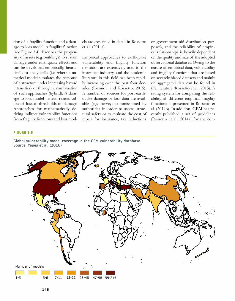
Global vulnerability model coverage in the GEM vulnerability database.Source: Yepes et al. (2016)
FIGURE 3.5
Number of models
1-3 4 5-6 7-11 12-22 23-46 47-98 99-215

CHAPTER 3 UNDERSTANDING DISASTER RISK: HAZARD RELATED RISK ISSUES - SECTION I
147
struction of empirical functions from single or multiple earthquake event databases.
Heuristic fragility and vulnerability functions have been derived either where there was limited information regarding past earthquakes or where the asset was difficult to model nu-merically (ATC 13, 1985; Jaiswal et al., 2012).
Characterisation of assets and population in a region and their susceptibility to suffer damages or losses
is one of the key elements by which to understand
risk.
An abundance of analytical fragility functions exists, which are predom-inantly derived for buildings and bridges. A variety of analysis methods and structural models with different levels of complexity (e.g. Martins et al., 2016; Akkar et al., 2005) have been used to construct such fragil-ity functions. The adequacy of the adopted approach to represent the fragility of the structure depends on the structure’s expected behaviour under ground shaking. A rating sys-tem for comparing the reliability of different analytical fragility functions is presented in Rossetto et al. (2014b) and guidelines for the construction of analytical vulnerability and fragility functions for low- to mid-rise build-ings can be found in D’Ayala et al. (2014) and for tall buildings in Porter et al. (2014).
It is clear that each approach to the construction of fragility and vulner-ability functions (i.e. empirical, ana-lytical, heuristic and hybrid) has its advantages and disadvantages. How-ever, in each case, for the function to be credible and useable, it is essential that the sources of uncertainty are identified and that the uncertainty as-sociated with the functions is quanti-fied. This is not common, and major sources of uncertainty are commonly ignored (e.g. record-to-record varia-bility, uncertainty in the damage cri-teria, building-to-building variability).
3.1.3.3 Existing exposure and vul-
nerability databases
Despite the usefulness of exposure information, the availability of open databases of exposure is quite limited. GEM released an exposure database in 2014 (Gamba, 2014) with building information on a global scale, but with different levels of detail depending on the country. The number of build-ings and dwellings was mostly calcu-lated using population data (GRUMP, CIESIN, 2004), and national or sub-national mapping schemes. For Eu-rope, these mapping schemes were developed using the results from the European project NERA. It is also worth mentioning the exposure da-tabase proposed by the United States Geological Survey (USGS) Prompt Assessment of Global Earthquakes for Response (PAGER) group, which also comprises worldwide informa-tion at the national scale (Jaiswal et al., 2010).
With regard to vulnerability databas-es, recently, several institutions have collected fragility and vulnerability
functions from the literature. The most notable examples are the GEM database of vulnerability and fragility functions for buildings, described in Yepes et al. (2016), and the FP7 Eu-ropean project SYNER-G database for infrastructure fragility (Crowley et al., 2014; Pitilakis et al., 2014). Figure 3.5 illustrates the global coverage of earthquake vulnerability functions in the GEM database. It highlights a lack of vulnerability functions for many developing countries at risk. Moreo-ver, all these databases indicate a pre-dominance of fragility over vulnera-bility functions and damage-to-loss models. The paucity of vulnerability functions for developing countries can be attributed to a lack of past event loss data to build or calibrate the vulnerability models, and the difficulty associated with modelling non-engi-neered buildings. Apart from vulner-ability functions, a number of indices exist that provide relative measures of vulnerability across geographical are-as and that incorporate socioeconom-ic measures. Forms of such empirical vulnerability indices are used in the Global Assessment Reports (support-ed by the Global Risk Data Platform of UNEP/GRID-Geneva) and by the USGS’s PAGER group.
3.1.4 Seismic risk
assessment, loss estimation and risk
mitigation
3.1.4.1 Early warning systems and near-real time loss
assessment

148
Emergency rescue reports from sever-al past earthquakes indicate that more than 90 % of successful rescues occur within the first 24-48 hours (Oliveira et al., 2006). Successful rescues de-pend greatly on the preparedness of the local authorities and the efficient allocation of limited resources shortly after seismic events. For this reason, a number of systems have been devel-oped in the last decades either to trig-ger early warnings or to rapidly assess the expected damages. EWS (Zollo et al., 2009; Alcik et al., 2009, Hoshiba et al., 2008) aim to launch alerts seconds before the arrival of the destructive seismic waves, usually through the interpretation of the amplitude of P waves. This lead-time may be useful to initiate emergency measures, such as the controlled shutdown of gas pipe-lines and critical facilities and speed
reduction of rapid-transit vehicles, and to advise the population to follow the necessary precautions (Wu and Kanamori, 2008). Several European projects have investigated the effec-tiveness of such systems for the Euro-pean territory (SAFER, n.d.; REAKT, n.d.), but currently a large-scale opera-tional system does not exist.
Near-real time loss assessment sys-tems focus on the estimation of the expected damage using existing ex-posure and vulnerability models, and ground shaking computed shortly after the seismic event. The USGS PAGER group has developed one of the best-known systems, which pro-vides first-order estimates of human and economic losses at a global scale (Wald et al., 2012). At the national level in Europe, a few systems have
also been developed for Italy, Bul-garia, Romania, Portugal and Turkey (e.g. Erduran et al., 2012; Erdik et al., 2003b). The ongoing pilot project ARISTOTLE (n.d.), funded by EU budget, will provide scientific support to European Emergency Response Coordination Centre (ERCC) in the period 2016-17, not only for earth-quakes, but also for other hazards such as tsunamis, volcanic activity and meteorological hazards.
3.1.4.2 Evaluation of
earthquake scenarios
The assessment of earthquake scenar-ios can play a critical role in the devel-opment of risk-reduction measures. These may include the creation of emergency plans, the development of
Seismic risk (left), social vulnerability (centre) and integrated risk (right) for PortugalSource: adapted from Burton and Silva (2015)
FIGURE 3.6

CHAPTER 3 UNDERSTANDING DISASTER RISK: HAZARD RELATED RISK ISSUES - SECTION I
149
infrastructure to support the affected regions or the organisation of earth-quake risk awareness campaigns. For example, Anhorn and Khazai (2014) investigated the suitability of shelter spaces in the Metropolitan Area of Kathmandu (Nepal), considering a set of potential destructive earthquakes. Likewise, Mendes-Victor et al. (1994) and ERSTA (2010) estimated the ex-pected economic and human losses for high-magnitude events in the city of Lisbon and the Algarve region, respectively. These results were used by the Portuguese Civil Protection authorities to elaborate seismic risk emergency plans. Scenario events may be based on past historical earthquakes (e.g. Bendimerad, 2001) or may be defined through the investigation of seismogenic sources around the re-gion of interest (e.g. Ansal et al., 2009). The distribution of ground shaking at the location of the collection of assets is used with fragility or vulner-ability functions to assess damage or losses, respectively. Several software packages can be used for the assess-ment of earthquake scenarios such as Earthquake Loss Estimation Routine (ELER) (Hancilar et al., 2010), Open-Quake (Silva et al., 2014b) or SEismic Loss EstimatioN using a logic tree Approach (SELENA) (Molina et al., 2010).
Several past European initiatives have covered the development of earth-quake scenarios for large urban cen-tres. The RISK-EU (2001-4; Mouroux and Le Brun, 2006) and LESSLOSS (2004-7; Calvi and Pinho, 2004) pro-jects explored the impact of several seismic events in urban centres such as Bucharest, Catania, Nice, Lisbon, Istanbul, Sofia and Thessaloniki. More recently, the European project
STREST (Harmonized approach to stress tests for critical infrastructures against natural hazards) (STREST, n.d.) explored the impact of specif-ic seismic events in critical facilities, such as industrial structures in Central Italy.
Hazard, exposure and vulnerability are the key
elements for seismic risk assessment to estimate
the consequences of earthquakes and the potential for human
and economic losses, which can support
decision-makers in the development of risk-reduction strategies.
These projects featured the involve-ment of several stakeholders to en-sure that the final results would be useful for disaster risk management (DRM).
3.1.4.3 Probabilistic seismic
risk assessment
The assessment of probabilistic earthquake losses can be performed through two main approaches: clas-sic PSHA-based risk or probabilistic event-based risk analyses (Cornell, 1968; McGuire, 2004; Silva, 2016). These methodologies have been fea-tured in software packages such as CAPRA (ERN-AL, 2009), Open-Quake (Silva et al., 2014b), SELE-
NA (Molina et al., 2010) or HAZUS (FEMA, 2003).
An example of a probabilistic earth-quake loss assessment is presented in Figure 3.6 for Portugal (first panel). In this study, average annual losses at the county level were calculated us-ing a time-independent PSHA mod-el (Silva et al., 2014a). This informa-tion can inform local governments, civil protection authorities and other stakeholders in the development of risk-reduction measures. These can include the improvement and/or enforcement of seismic codes (e.g. Spence, 2004), the development of retrofitting campaigns (e.g. Erdik and Durukal, 2008), the improvement of urban planning (Sengezer and Koc, 2005), the development of financial mechanisms to transfer the risk from the public sector to the international reinsurance market (e.g. Bommer et al., 2002), or the strategic allocation of funds for risk reduction and preven-tion. For example, in 2009, the Italian Government invested almost EUR 1 billion in a seismic prevention pro-gramme at the national scale, led by the Civil Protection Department. In order to understand how to distribute the funds across the different regions in Italy, a seismic risk assessment study was conducted and the funds were distributed proportionally to the earthquake risk (Dolce, 2012). An effort to assess quantitatively earth-quake risk in Greece in terms of eco-nomic impact was developed by Papa-dopoulos and Arvanitides (1996).
Despite the usefulness of such met-rics, they neglect local socioeconomic conditions. For this reason, several so-cial scientists (e.g. Carreño et al., 2007; Khazai and Bendimerad, 2011) have

150
explored the concept of integrated or holistic risk. This approach aims to aggravate or attenuate the direct risk (e.g. average annual losses) according to a social vulnerability index. This index is derived considering a large number of socioeconomic indicators such as crime, education, poverty, age or unemployment. The distribution of socioeconomic vulnerability and inte-grated risk for Portugal is presented in Figure 3.6 (Burton and Silva, 2015).
These results reflect the earthquake resilience of different regions within the same country, and, thus, where a longer recovery time should be expected in the event of a disaster. Within the Horizon 2020 (H2020) framework, the SERA project (Seis-mology and Earthquake Engineering Research Infrastructure Alliance for Europe) will cover the probabilistic earthquake loss assessment for all Eu-ropean countries.
It is also important to understand that modern societies strongly rely on in-ter-related systems (building stock, power, water supply, transportation), and that a natural catastrophe might initiate a cascading effect, whereby one disaster triggers another. These effects have been explored in the two Euro-pean projects Syner-G and STREST.
3.1.5 Conclusions and key
messages
In the last decades, earthquakes have been responsible for approximately one-fifth of global annual economic losses, and for a death toll of more than 25 000 people per year. This can
have a serious impact on sustainable development, the creation of jobs and the availability of funds for pov-erty reduction initiatives. This chapter has described several recent develop-ments across the different disciplines of earthquake risk assessment and has highlighted a multitude of re-sources currently available to the dis-aster risk-reduction community. The key messages from this chapter are summarised below.
PartnershipThe assessment of the impact of earthquakes incorporates many scien-tific fields, such as seismology, earth-quake engineering and social sciences. Neglecting any of these fields will in-evitably reduce the accuracy, reliabili-ty and usefulness of the resulting risk metrics. The process of risk identi-fication should involve stakeholders from the public and private sectors, and should support ongoing national and international initiatives with the mandate to calculate, communicate and reduce earthquake risk.
KnowledgeIn the past two decades, the Europe-an Union has funded a large number of projects that have significantly ad-vanced the science of earthquake haz-ard, vulnerability and risk modelling. Other national and international pro-grammes have also produced datasets, models and tools that are fundamen-tal for the assessment of earthquake risk. Leveraging on this wealth of resources will reduce the replication of efforts. It is important to investi-gate efficient approaches to the ap-plication of existing earthquake risk knowledge into DRM, as described in the preceding section.
InnovationEarthquake risk assessment has reached a considerable level of matu-rity, which requires complex software packages (e.g. ELER, HAZUS, Open-Quake, CAPRA or SELENA). It is fundamental to incorporate the wide spectrum of uncertainties from the different risk components (exposure, vulnerability, hazard). Satellite image-ry and VGI are enabling the character-isation of the built environment with unprecedented temporal and spatial detail. Moreover, the development of risk-reduction strategies should not only rely on the direct (or physical) impact, but should also incorporate socioeconomic aspects, thus consid-ering the capability of the society to recover from destructive events.

180
REFERENCES CHAPTER 3 - SECTION I
IntroductionUNISDR, 2015. Sendai framework for disaster risk reduction 2015–2030. United Nations International Strategy for Disaster Re-
duction. http://www.wcdrr.org/uploads/Sendai_Framework_for_Disaster_Risk_Reduction_2015-2030.pdf, [accessed 04 April 2016].
Woo G., 2010. Operational earthquake forecasting and risk management. Seismological Research Letters 81(5).
3.1 Geophysical risk: earthquakesAkkar, S., Sucuoglu, H., Yakut, A., 2005. Displacement-based fragility functions for low- and mid-rise ordinary concrete buildings.
Earthquake Spectra 21(4), 901-927.Albini, P., Musson, R., Rovida, A., Locati, M., Gomez Capera, A., Vigano, D., 2014. The global earthquake history. Earthquake Spectra
30(2), 607–24.Alcik, H., Ozel, O., Apaydin, N., Erdik, M., 2009. A study on warning algorithms for Istanbul earthquake early warning system. Geo-
physical Research Letters 36(5), L00B05.Anhorn, J., Khazai, B., 2015. Open space suitability analysis for emergency shelter after an earthquake. Natural Hazards and Earth
System Sciences 1 (2), 4263-4297.Ansal, A., Akinci, A., Cultrera, G., Erdik, M., Pessina, V., Tonuk, G., Ameri, G., 2009. Loss estimation in Istanbul based on deterministic
earthquake scenarios of the Marmara Sea region (Turkey). Soil Dynamics and Earthquake Engineering 29, 699–709.ARISTOTLE, n.d. All Risk Integrated System TOwards Trans-boundary hoListic Early-warning. http://aristotle.ingv.it, [accessed 13
April, 2017].ATC-13, 1985. Earthquake damage evaluation data for California. Applied Technology Council. Redwood City, CA, USA.Basili, R., Tiberti, M.M., Kastelic, V., Romano, F., Piatanesi, A., Selva, J., Lorito, S., 2013. Integrating geologic fault data into tsunami
hazard studies. Natural Hazards Earth System Sciences 13, 1025–1050.Bazzurro, P., Cornell, C., 1999. Disaggregation of seismic hazard. Bulletin of the Seismological Society of America 89: 501-520.Bendimerad, F., 2001. Loss estimation: a powerful tool for risk assessment and mitigation. Soil Dynamics and Earthquake Engi-
neering 21 (5), 467-472.Bilham, R., 2004. Earthquakes in India and the Himalaya: tectonics, geodesy and history. Annals of Geophysics 47 (2–3), 839-
858.Bird, P., 2003. An updated digital model of plate boundaries. Geochemistry, Geophysics, Geosystems 4 (3), 1027.Bommer, J., Abrahamson, N., 2006. Why do modern probabilistic seismic-hazard analyses often lead to increased hazard esti-
mates?. Bulletin of the Seismological Society of America 96 (6), 1967-1977.Bommer, J., Douglas, J., Scherbaum, F., Cotton, F., Bungum, H., Fah, D., 2010. On the selection of ground-motion prediction equations
for seismic hazard analysis. Seismological Reseach Letters 81, 783–793.Bommer, J., Spence, R., Erdik, M., Tabuchi, S., Aydinoglu, N., Booth, E., Re, D., Pterken, D., 2002. Development of an Earthquake Loss
Model for Turkish Catastrophe Insurance. Journal of Seismology 6, 431-446.Brzev, S., Scawthorn, C., Charleson, A., Allen, L., Greene, M., Jaiswal, K., Silva, V., 2013. GEM Building Taxonomy Version 2.0, GEM
Technical Report 2013-02 V1.0.0. GEM Foundation, Pavia, Italy. doi: 10.13117/GEM.EXP-MOD.TR2013.02.Burton, C., Silva, V., 2015. Assessing Integrated Earthquake Risk in OpenQuake with an Application to Mainland Portugal Earthquake
Spectra 32 (3), 1383-1403.Calvi, G., Pinho, R., 2004. LESSLOSS — A European integrated project on risk mitigation for earthquakes and landslides. IUSS Press,
Pavia, Italy.Carreño, L., Cardona, O., Barbat, A., 2007.Urban seismic risk evaluation: a holistic approach Natural Hazards, 40, 137-172.CIESIN, 2004. Global Rural-Urban Mapping Project (GRUMP) — Urban extents. Center for International Earth Science Information
Network. http://sedac.ciesin. columbia.edu/data/set/grump-v1-urban-extents [Accessed 21 September, 2016].Cornell, C., 1968. Engineering seismic risk analysis. Bulletin of the Seismological Society of America 58, 1583-1606.Cotton, F., Scherbaum, F., Bommer, J., Bungum, H., 2006. Criteria for selecting and adjusting ground-motion models for specific
target regions: application to central Europe and rock sites. Journal of Seismology 10, 137–156.Crowley, H., Colombi, M., Silva, V., 2014. Epistemic uncertainty in fragility functions for European RC buildings. In: Pitilakis, K., Crow-
ley, H., Kaynia, A.M. (Eds), SYNER-G: Typology definition and fragility functions for physical elements at seismic risk: buildings, lifelines, transportation networks and critical facilities, Springer, Dordrech, Netherlands, pp. 95-109.
Crowley, H., Miriam, C., Borzi, B., Faravelli, M., Onida, M., Lopez, M., Polli, D., Meroni, F., 2009. A comparison of seismic risk maps for Italy. Bulletin of Earthquake Engineering 7 (1), 149-180.
Crowley, H., Ozcebe, S., Spence, R., Foulser-Piggott, R., Erdik, M., Alten, K., 2012. Development of a European building inventory database. In: Proceedings of the 15th World Conference on Earthquake Engineering, Lisbon, Portugal.
D’Ayala, D., Meslem, A., Vamvatsikos, D., Porter, K., Rossetto, T., 2015. Guidelines for analytical vulnerability assessment of low/mid-rise buildings, GEM Technical Report 2014-12. GEM Foundation, Pavia, Italy.
Danciu, L., Kale, O., Akkar, S.,2016. The 2014 Earthquake Model of the Middle East: ground motion model and uncertainties. Bulletin of Earthquake Engineering.
Delavaud, E., Cotton, F., Akkar, S., Scherbaum, F., Danciu, L., Beauval, C., Drouet, S., Douglas, J., Basili, R., Sandıkkaya, M.A., Segou, M., Faccioli, E., Theodoulidis, N., 2012. Toward a ground-motion logic tree for probabilistic seismic hazard assessment in Europe. Journal of Seismology 16, 451–473.
Dolce, M., 2012. The Italian National Seismic Prevention Program. In: Proceedings of the 15th World Conference on Earthquake Engineering, Lisbon, Portugal.

CHAPTER 3 UNDERSTANDING DISASTER RISK: HAZARD RELATED RISK ISSUES - SECTION I
181
Douglas, J., 2010. Consistency of ground-motion predictions from the past four decades. Bulletin of Earthquake Engineering 8, 1515–1526.
EFEHR, n.d. The European Facilities for Earthquake Hazard & Risk. www.efehr.org, [accessed 13 April, 2017].Erdik, M Durukal, E., 2008. Earthquake risk and its mitigation in Istanbul. Natural Hazards 44 (2), 181-197.Erdik, M., Aydinoglu, N., Fahjan, Y., Sesetyan, K., Demircioglu, M., Siyahi, B., Durukal, E., Ozbey, C., Biro, Y., Akman, H., Yuzugullu, O,.
2003a. Earthquake risk assessment for Istanbul Metropolitan Area. Earthquake Engineering and Engineering Vibration 2 (1), 1-23.
Erdik, M., Fahjan, Y., Orguz, O., AlcikH, Mert A, Gul M., 2003b. Istanbul Earthquake Rapid Response and the Early Warning System. Bulletin of Earthquake Engineering 1 (1), 157-163.
Erduran, E., Lang, D., Lindholm, C., Toma-Danila, D., Balan, S., Ionescu, V., Aldea, A., Vacareanu, R., Neagu, C., 2012. Real-Time Earthquake Damage Assessment in the Romanian-Bulgarian Border Region. In: Proceedings of the 15th World Conference on Earthquake Engineering, Lisbon, Portugal.
ERN-AL, 2009. Informe Técnico ERN-CAPRA-T1-3. Metodología de análisis probabilista del riesgo.ERSTA, 2010. Estudo do risco sísmico e de tsunamis do Algarve. Autoridade Nacional de Protecção Civil, Carnaxide, Portugal (in
Portuguese).European Committee for Standarisation (CEN), 2005. EN 1998-1 Eurocode 8: Design of structures for earthquake resistance. Part
1: General rules, seismic actions and rules for buildings. European Committee for Standardization, Brussels, Belgium.FEMA, 2003. HAZUS-MH technical manual. Federal Emergency Management Agency, Washington, USA.Gamba, P., 2014. Global Exposure Database: scientific features. GEM Technical Report 2014-10. GEM Foundation, Pavia, Italy.Giardini, D., 1999. The Global Seismic Hazard Assessment Program (GSHAP) 1992-1999. Annali di Geofisica 42(6), :957-1230.Hancilar, U., Tuzun, C., Yenidogan, C. Erdik, M., 2010. ELER software—a new tool for urban earthquake loss assessment. Natural
Hazards and Earth Systems Sciences 10, 2677-2696. Hoshiba, M., Kamigaichi, O., Saito, O., Tsukada, S., Hamada, N., 2008. Earthquake early warning starts nationwide in Japan. EOS
Transactions AGU 89 (8), 73-74.Ioannou, I. , Rossetto, T., 2015. Empirical Fragility. In: Beer, M., Kougioumtzoglou, I.A., Patelli, E., Siu-Kui Au, I. (Eds.), Encyclopedia of
Earthquake Engineering. Springer, Berlin Heidelberg, pp. 976-986. Jaiswal, K., Aspinall, W., Perkins, D., Wald, D., Porter, K., 2012. Use of expert judgement elicitation to estimate seismic vulnerability
of selected building types. In: Proceedings of the 15th World Conference on Earthquake Engineering, Lisbon, Portugal.Jaiswal, K., Wald, D., Porter, K., 2010. A global building inventory for earthquake loss assessment and risk management. Earthquake
Spectra 26(3), 731-748.Kale, O., Akkar, S., 2013. A new perspective for selecting and ranking ground-motion prediction equations (GMPEs): the euclidian
distance-based ranking method. Bulletin of the Seismological Society of America, 103(2A):1069–1084.Kale, O., Akkar, S., Ansari, A., Hamzehloo, H.,2015). A ground-motion predictive model for Iran and Turkey for horizontal PGA, PGV
and 5 %-damped response spectrum: investigation of possible regional effects. Bulletin of the Seismological Society of America 105, 963–980.
Khazai, B., Bendimerad, F., 2011. Risk and resiliency indicators, EMI Topical Report 565 TR-1 03.Martínez Solares, J., López Arroyo, A., 2004. The great historical 1755 earthquake. Effects and damage in Spain. Journal of Seis-
mology 8, 275-294. Martins, L., Silva, V., Marques, M., Crowley, H., Delgado ,R. (2016). Development and assessment of damage-to-loss models for
moment-frame reinforced concrete buildings. Earthquake Engineering and Structural Dynamics 45 (5),797–817.McGuire, R., (1976). Fortran program for seismic risk analysis. U.S. Geological Survey Open-File Report 76–67. https://pubs.usgs.
gov/of/1976/0067/report.pdf [accessed 04 April, 2016]McGuire, R., 2004. Seismic hazard and risk analysis. Earthquake Engineering Research Institute, Oakland, USA.Mendes-Victor, L., Oliveira, C., Pais, I., Teves-Costa, P., 1994. Earthquake damage scenarios in Lisbon for disaster preparedness. In:
Tucker, B.E., Erdik, M. Hwang, C.N. (Eds). Issues in urban earthquake risk. Kluwer Academic Publishers, Dordrecht, The Nether-lands; Boston, USA, pp. 265-289.
Molina, S., Lang, D., Lindholm, C., 2010. SELENA: An open-source tool for seismic risk and loss assessment using a logic tree com-putation procedure. Computers & Geosciences 36, 257-269.
Mouroux, P., Le Brun, B., 2006. Presentation of RISK-UE Project. Bulletin of Earthquake Engineering 4, 323-339.NERA, n.d. NERA: Network of European Research Infrastructures for Earthquake Risk Assessment and Mitigation. http://www.nera-
eu.org/, [accessed 12 April, 2017].NGDC, n.d. Natural Hazards Data, Images and Education. NOAA's National Centers for Environmental Information (NCEI) (formerly
the National Geophysical Data Center). https://www.ngdc.noaa.gov/hazard/hazards.shtml, [accessed 12 April, 2017].Oliveira, C., Roca, A., Goula, X., 2006. Assessing and managing earthquake risk: geo-scientific and engineering knowledge for earth-
quake risk mitigation — development tools, techniques. Springer, Dordrecht, Netherlands.Pagani, M., Monelli, D., Weatherill, G., Danciu, L., Crowley, H., Silva, V., Henshaw, P., Butler, L., Nastasi, M., Panzeri, L., Simionato, M.,
Vigano, D., 2014. OpenQuake Engine: An open hazard (and risk) software for the Global Earthquake Model. Seismological Re-search Letters 85 (3),692-702.
Papadopoulos, G.A., Arvanitides, A. 1996. Earthquake risk assessment in Greece. In: Schenk, V., (Ed.), Earthquake hazard and risk, advances in natural & technological hazards research, Kluwer Academic Publishers, USA.
Pesaresi, M., Ehrlich, D., Ferri, S., Florczyk, A., Freire, S., Halkia, M., Julea, A., Kemper, T., Soille, P., Syrris, V., 2016. Operating proce-dure for the production of the Global Human Settlement Layer from Landsat data of the epochs 1975, 1990, 2000, and 2014. Technical Report EUR 27741 EN, Joint Research Center, Luxemburg.
Petersen, M., Moschetti, M., Powers, P., Mueller, C., Haller, K., Frankel, A., Field, N., Chen, R., Rukstales, K.S., Luco, N., Wheeler, R., Williams, R., Olsen, A., 2015. The 2014 United States National Seismic Hazard Model. Earthquake Spectra 31(S1), S1–S30.
Pitilakis, K., Crowley, H., Kaynia, A., 2014. SYNER-G: typology definition and fragility functions for physical elements at seismic risk: buildings, lifelines, transportation networks and critical facilities. Springer, Dordrecht, Netherlands.

182
Pittore, M., Wieland, M., Fleming, K., 2016. Perspectives on global dynamic exposure modelling for geo-risk assessment. Natural Hazards, 86 (S1), 7-30.
Porter, K., Farokhnia, K., Vamvatsioks, V., Cho, I., 2014. Guidelines for analytical vulnerability assessment of high-rise buildings. GEM Technical Report 2014. GEM Foundation, Pavia, Italy.
REAKT, n.d. Strategies and tools for real time earthquake Risk Reduction. www.reaktproject.eu, [accessed 13 April, 2017].Renault, P., 2014. Approach and challenges for the seismic hazard assessment of nuclear power plants: the Swiss Experience.
Bollettino di Geosicia Teorica ed Applicata 55(1), 149–164.Rossetto, T., D’Ayala, D., Ioannou, I., Meslem, A., 2014b. Evaluation of existing fragility curves. In: Pitilakis, K., Crowley, H. and Kaynia,
A.M. (eds), SYNER-G: Typology definition and fragility functions for physical elements at seismic risk: buildings, lifelines, trans-portation networks and critical facilities, Springer, Dordrech, Netherlands, pp. 47-93.
Rossetto, T., Ioannou, I., Grant, D., 2014a. Guidelines for empirical vulnerability assessment. GEM Technical Report 2014-11. GEM Foundation, Pavia, Italy.
Rossetto, T., Ioannou, I., Grant, D., 2015. Existing Empirical Fragility and Vulnerability Functions: Compendium and Guide for Selec-tion (GEM Technical Report). GEM Foundation, Pavia, Italy.
SAFER, n.d. Seismic early warning for Europe. http://www.amracenter.com/SAFER/index.htm, [accessed 13 April, 2017].Scherbaum, F., Delavaud, E., Riggelsen, C., 2009. Model selection in seismic hazard analysis: an informationtheoretic perspective.
Bulletin of the Seismological Society of America 99 (6), 3234–3247.Sengezer, B Koç, E., 2005. A critical analysis of earthquakes and urban planning in Turkey. Disasters 29 (2), 171-194.SHARE, n.d. Seismic Hazard Harmonization in Europe . www.share-eu.org, [accessed 13 April, 2017].SHEEC, n.d. The SHARE European Earthquake Catalogue. www.emidius.eu/SHEEC, [accessed 13 April, 2017].Silva, V., 2016. Critical Issues on Probabilistic Earthquake Loss Assessment. Journal of Earthquake Engineering 20 (8), 1322-
1341.Silva, V., Crowley, H., Bazzurro, P., 2015. Exploring Risk-targeted Hazard Maps for Europe. Earthquake Spectra 32 (2), 1165-1186.Silva, V., Crowley, H., Pagani, M., Monelli D, Pinho, R., 2014b. Development of the OpenQuake engine, the Global Earthquake Model’s
open-source software for seismic risk assessment. Natural Hazards 72 (3), 1409-1427.Silva, V., Crowley, H., Pinho, R., Varum, H., 2014a. Seismic Risk Assessment for mainland Portugal. Bulletin of Earthquake Engineer-
ing 13 (2), 429-457.Spence, R., 2004. Risk and regulation: can improved government action reduce the impacts of natural disasters?. Building Research
& Information 32 (5).Storchak, D., Di Giacomo, D., Endgdahl, E., Harris, J., Bondár, I., Lee, W., Bormann, P., Villaseñor, A., 2015. The ISC-GEM Global In-
strumental Earthquake Catalogue (1900 — 2009): Introduction. Physics of the Earth and Planetary Interiors 239: 48–63.Strasser, F., Abrahamson, N., Bommer, J., 2009). Sigma: Issues, Insights, and Challenges. Seismological Research Letters 80, 41-
56.STREST, n.d. Harmonized approach to stress tests for critical infrastructures against natural hazards. www.strest-eu.org, [accessed
13 April, 2017].Wald, D., Earle, P., Allen, T., Jaiswal, K., Porter, K., Hearne, M., 2012. Development of the US Geological Survey’s PAGER system
(prompt assessment of global earthquakes for response). In: Proceedings of the 14th World Conference on Earthquake Engi-neering, Lisbon, Portugal.
Weatherill, G, Pagani, M., Garcia, J., 2016. Exploring Earthquake Databases for the Creation of Magnitude-Homogeneous Cata-logues: Tools for Application on a Regional and Global Scale. Geophysical Journal International 206 (3), 165-276.
Wieland, M., Pittore, M., Parolai, S. Zschau, J. (2012). Remote sensing and omnidirectional imaging for efficient building inventory data capturing: application within the Earthquake Model Central Asia. In: Proceedings of the IEEE IGARSS 2012, Munich, Ger-many.
Woessner, J., Danciu, L., Giardini, D., Crowley H, Cotton F, Grunthal G, SHARE Consortium (2015) The 2013 European seismic hazard model: key components and results. Bulletin of Earthquake Engineering 13 (12), 3553-3596.
Wu, Y.-M. Kanamori, H., 2008. Development of an Earthquake Early Warning System Using Real-Time Strong Motion Signals. Sensors 8 (1), 1-9.
Yepes, C., Silva, V., Rossetto, T., D’Ayala, D., Ioannou, I., Meslem, A., Crowley, H., 2016. The Global Earthquake Model Physical Vulner-ability Database. Earthquake Spectra 32 (4), 2567-2585.
Zafarani, H., Mousavi, M., 2014. Applicability of different ground-motion prediction models for northern Iran. Natural Hazards, 73 (3), 1199–1228.
Zollo, A., Iannaccone, G., Lancieri, M., Cantore, L., Convertito, V., Emolo, A., Festa, G., Gallovic, F., Vassallo, M., Martino, C., Satriano, C., Gasparini, P., 2009. The earthquake early warning system in Southern Italy: methodologies and performance evaluation. Geophysical Research Letters, 36 (5).
3.2 Geophysical risk: volcanic activityAcocella, V., Di Lorenzo, R., Newhall, C., Scandone, R., 2015. An overview of recent (1988 to 2014) caldera unrest: Knowledge and
perspectives. Reviews of Geophysics 53, 896-955. Aiuppa, A., Burton, M., Caltabiano, T., Giudice, G., Guerrieri, S., Liuzzo, M., Mure, F., Salerno, G., 2010. Unusually large magmatic CO2
gas emissions prior to a basaltic paroxysm. Geophysical Research Letters 37, L17303.Aiuppa, A., Moretti, R., Federico, C., Giudice, G., Gurrieri, S., Liuzzo, M., Papale, P., Shinohara, H., Valenza, M., 2007. Forecasting Etna
eruption by real time evaluation of volcanic gas composition. Geology 35, 1115-1118. Aiuppa, A., Tamburello, G., Di Napoli, R., Cardellini, C., Chiodini, G., Giudice, G., Grassa, F., Pedone, M., 2013. First observations of
the fumarolic gas output from a restless caldera: Implications for the current period of unrest (2005–2013) at Campi Flegrei. Geochemistry Geophysics Geosystems 14, 4153–4169.
Aspinall, W., 2010. A route to more tractable expert advice. Nature 463: 294-295.

CHAPTER 3 UNDERSTANDING DISASTER RISK: HAZARD RELATED RISK ISSUES - SECTION I
183
Aspinall, W.P., 2006. Structured elicitation of expert judgment for probabilistic hazard and risk assessment in volcanic eruptions. In: Mader, H.M., Coles, S. G., Connor, C.B., Connor, L.J. (Eds.), Statistics in Volcanology, Geological Society of London on behalf of IAVCEI, pp. 15–30.
Auker, M., Sparks, R., Siebert, L., Crosweller, H., Ewert, J., 2013. A statistical analysis of the global historical volcanic fatalities record. Journal of Applied Volcanology 2 (2), 1-24.
Bagnardi, M., González, P.J., Hooper, A., 2016. High-resolution digital elevation model from tri-stereo Pleiades-1 satellite imagery for lava flow volume estimates at Fogo Volcano. Geophysical Research Letters 43, 6267–6275.
Barclay, J., Haynes, K., Houghton, B., Johnston, D.M., 2015. Social processes and volcanic risk reduction. In: Sigurdsson, H., Houghton, B., McNutt, S., Rymer, H., Stix, J. (eds), Encyclopedia of Volcanoes. Academic Press, Amsterdam, Netherlands.
Barclay, J., Haynes, K., Mitchell, T. O. M., Solana, C., Teeuw, R., Darnell, A., Crosweller, H.S., Cole, P., Pyle, D., Lowe, C., Fearnley, C., 2014. Framing volcanic risk communication within disaster risk reduction: finding ways for the social and physical sciences to work together. In: Liverman, D., Pereira, C., Marker, B., (Eds.), Communicating Environmental Geoscience, Volume 305. Geological Society, London, UK, pp. 163-177.
Bartolini, S., Bolós, X., Martí, J., Riera Pedra, E., Planaguma, L., 2015. Hazard assessment at the Quaternary La Garrotxa Volcanic Field (NE Iberia). Natural Hazards 78 (2), 1349-1367.
Baxter, P. J., Aspinall, W.P., Neri, A., Zuccaro, G., Spence, R.J.S., Cioni, R., Woo, G., 2008. Emergency planning and mitigation at Vesu-vius: A new evidence-based approach. Journal of Volcanology and Geothermal Research 178, 454-473.
Baxter, P.J., Boyle, R., Cole, P., Neri, A., Spence, R., Zuccaro, G., 2005. The impacts of pyroclastic surges on buildings at the eruption of the Soufriere Hills volcano, Montserrat. Bulletin of Volcanology 67, 292-313.
Bayarri, M.J., Berger, J.O., Calder, E.S., Patra, A.K., Pitman, E.B., Spiller, E.T., Wolpert, R.L., 2015. Probabilistic quantification of haz-ards: A methodology using small ensembles of physics based simulations and statistical surrogates. International Journal for Uncertainty Quantification 54, 297-325.
Bebbington, M.S, Cronin S.J. 2010. Spatio-temporal hazard estimation in the Auckland volcanic field, New Zealand, with a new event-order model. Bulletin of Volcanology, 73, 55–72.
Biass, S., Bonadonna, C., Di Traglia, F., Pistolesi, M., Rosi, M., Lestuzzi, P., 2016a. Probabilistic evaluation of the physical impact of future tephra fallout events for the Island of Vulcano, Italy. Bulletin of Volcanology 78, 37.
Biass, S., Falcone, J.L., Bonadonna, C., Di Traglia, F., Pistolesi, M., Rosi, M., Lestuzzi, P., 2016b. Great Balls of Fire: A probabilistic approach to quantify the hazard related to ballistics — A case study at La Fossa volcano, Vulcano Island, Italy. Journal of Vol-canology and Geothermal Research 325, 1-14.
Biass, S., Scaini, C., Bonadonna, C., Folch, A., Smith, K., Höskuldsoon, A., 2014. A multi-scale risk assessment for tephra fallout and airborne concentration from multiple Icelandic volcanoes - Part 1: Hazard assessment. Natural Hazards and Earth System Sciences 14, 2265–2287.
Biggs, J., Anthony, E.Y., Ebinger, C.J. 2009. Multiple inflation and deflation events at Kenyan volcanoes, East African Rift. Geology, 37, 979-982.
Biggs, J., Ebmeier, S.K., Aspinall, W.P., Lu, Z., Pritchard, M.E., Sparks, R.S.J., Mather, T.A., 2014. Global link between deformation and volcanic eruption quantified by satellite imagery. Nature Communications 5, 3471-3471.
Bird, D.K., Gisladottir, G. and Dominey-Howes, D., 2010. Volcanic risk and tourism in southern Iceland: Implications for hazard, risk and emergency response education and training. Journal of Volcanology and Geothermal Research, 189, 33-48.
Bird, P., 2003. An updated digital model of plate boundaries, Geochemistry. Geophysics, Geosystems, 4 (3), 1027.Birkmann, J., 2007. Risk and vulnerability indicators at different scales: applicability, usefulness and policy implications. Environ-
mental Hazards 7, 20-31.Bonadonna C., Costa, A., 2012. Estimating the volume of tephra deposits: A new simple strategy, Geology, 40 (5), 415–418.Bonadonna, C., 2006. Probabilistic modelling of tephra dispersal. In: Mader, H., Cole, S., Connor C.B. (Eds.), Statistics in volcanology.
IAVCEI Series Volume 1. Geological Society, London, UK, pp. 243-259.Bonadonna, C., Biass, S., Costa, A., 2015. Physical characterization of explosive volcanic eruptions based on tephra deposits: Prop-
agation of uncertainties and sensitivity analysis. Journal of Volcanology and Geothermal Research 296, 80–100. Bonadonna, C., Folch, A., Loughlin, S. and Puempel, H., 2012. Future developments in modelling and monitoring of volcanic ash
clouds: Outcomes from the first IAVCEI-WMO workshop on Ash Dispersal Forecast and Civil Aviation. Bulletin of Volcanology 74, 1-10.
Boué, A., Lesage, P., Cortés, G., Valette, B., Reyes Dávila, G., Arámbula Mendoza, R., Budi Santoso, A., 2016. Journal of Volcanology and Geothermal Research 327, 622-633.
Bretton R.J., Gottsman J.H., Aspinall W.P., Christie R.B., 2015. Implications of legal scrutiny processes (including the L’Aquila trial and other recent court cases) for future volcanic risk governance. Journal of Applied Volcanology 4 (1), 18.
Brown, S.K., Crosweller, H.S., Sparks, R.S.J., Cottrell E., Deligne, N.I., Ortiz Guerrero, N., Hobbs, L., Kiyosugi, K., Loughlin, S.C., Siebert, L., Takarada, S., 2014. Characterisation of the Quaternary eruption record: analysis of the Large Magnitude Explosive Volcanic Eruptions (LaMEVE) database. Journal of Applied Volcanology 3 (5), 22.
Brown, S.K., Loughlin, S.C., Sparks, R.S.J., Vye-Brown, C., Barclay, J., Calder, E., Cottrell, E., Jolly, G., Komorowski, J.C., Mandeville, C., Newhall, C., Palma, J., Potter, S., Valentine, G., 2015. Global volcanic hazard and risk. In: Loughlin, S.C., Sparks, R.S.J., Brown, S.K., Jenkins, S.F., Vye-Brown, C., (eds), Global Volcanic Hazards and Risk. Cambridge University Press, Cambridge, pp. 81 – 173.
Calder, E.S., Wagner, K. Ogburn, S.E. (2015). Volcanic hazard maps. In: Loughlin, S.C., Sparks, R.S.J., Brown, S.K., Jenkins, S.F., Vye-Brown, C. (eds), Global Volcanic Hazards and Risk. Cambridge University Press, Cambridge, UK.
Cannavò, F., Camacho, A. G., González, P. J., Mattia, M., Puglisi, G. and Fernández, J., 2015. Real Time Tracking of Magmatic Intrusions by means of Ground Deformation Modeling during Volcanic Crises, Scientific Reports 5.
Carlsen, H. K., Hauksdottir, A., Valdimarsdottir, U. A., Gíslason, T., Einarsdottir, G., Runolfsson, H., Briem, H., Finnbjornsdottir, R. G., Gudmundsson, S. and Kolbeinsson, T. B., 2012. Health effects following the Eyjafjallajökull volcanic eruption: a cohort study. BMJ Open, 2, e001851.
Cashman, K.V., Stephen, R., Sparks, J., 2013. How volcanoes work: A 25 year perspective. Bulletin of the Geological Society of

184
America 125, 664-690.Charbonnier S.J., Germa A., Connor C.B., Gertisser R., Preece K., Komorowski J.C., Lavigne F., Dixon T.and Connor, L. undefined, 2013.
Evaluation of the impact of the 2010 pyroclastic density currents at Merapi volcano from high-resolution satellite imagery, field investigations and numerical simulations. Journal of Volcanology and Geothermal Research 261 (295), 315.
Chiodini, G., Caliro, S., De Martino, P., Avino, R., Gherardi, F., 2012. Early signals of new volcanic unrest at Campi Flegrei caldera? Insights from geochemical data and physical simulations. Geology 40, 943-946.
Chiodini, G., Paonita, A., Aiuppa, A., Costa, A., Caliro S., De Martino, P., Acocella, V., Vandemeulebrouck, J., 2016. Magmas near the critical degassing pressure drive volcanic unrest towards a critical state. Nature Communications 7, 13712.
Chiodini, G., Pappalardo, L., Aiuppa, A., and Caliro, S., 2015. The geological CO2 degassing history of a long-lived caldera. Geology 43 (9), 767-770.
Conde, V., Robidoux, P., Avard, G., Galle, B., Aiuppa, A., Muñóz, A., 2013. Measurements of SO2 and CO2 by combining DOAS, Multi-GAS and FTIR: study cases from Turrialba and Telica volcanoes. International Journal of Earth Sciences 103 (8), 2335-2347.
Connor, C., Bebbington, M., Marzocchi, W., 2015. Probabilistic Volcanic Hazard Assessment. In: Sigurdsson, H., Houghton, B., McNutt, S., Rymer, H., Stix, S., (eds.), Encyclopedia of Volcanoes. Academic Press, Amsterdam, Netherlands, pp. 897-910.
Connor, L. J., Connor, C. B., Meliksetian, K., Savov, I. 2012. Probabilistic approach to modelling lava flow inundation: a lava flow hazard assessment for a nuclear facility in Armenia. Journal of Applied Volcanology, 1, 3.
Coppola, D., Laiolo, M., Cigolini, C., Delle Donne, D., Ripepe, M., 2015. Enhanced volcanic hot-spot detection using MODIS IR data: results from the MIROVA system. In: Harris, A.J.L., De Groeve, T., Garel, F., Carn, S.A. (Eds.), Detecting, modelling and responding to effusive eruptions. Geological Society, London, UK.
Cottrell, E., 2014. Global Distribution of Active Volcanoes. In: Papale, P. (ed.) Volcanic Hazards, Risks and Disasters. Academic Press, pp. 1-18.
Craig, H., Wilson, T., Stewart, C., Outes, V., Villarosa, G., Baxter, P., 2016. Impacts to agriculture and critical infrastructure in Argentina after ashfall from the 2011 eruption of the Cordon Caulle volcanic complex: an assessment of published damage and function thresholds. Journal of Applied Volcanology 5, 7.
Cutter, S.L., 2013. Vulnerability. In: Encyclopedia of Natural Hazards, Encyclopedia of Earth Sciences Series. Springer-Verlag, Berlin, Heidelberg, Germany.
De Natale, G., Troise, C., Pingue, F., Mastrolorenzo, G., Pappalardo, L., Battaglia, M., Boschi, E., 2006. The Campi Flegrei caldera: unrest mechanisms and hazards. In: Troise, C., De Natale, G., Kilburn, C.R.J. (eds.), Mechanisms of Activity and Unrest at Large Calderas. Geological Society, London, UK, pp. 25–45.
Deligne, N.I., Coles, S.G., Sparks, R.S.J., 2010. Recurrence rates of large explosive volcanic eruptions. Journal of Geophysical Re-search: Solid Earth 115, B06203.
Doyle, E. H., McClure, J., Johnston, D. M., Paton, D., 2014. Communicating likelihoods and probabilities in forecasts of volcanic erup-tions. Journal of Volcanology and Geothermal Research 272, 1-15.
Doyle, E. H., Paton, D. Johnston, D. M., 2015. Enhancing scientific response in a crisis: evidence-based approaches from emergency management in New Zealand. Journal of Applied Volcanology 4,1.
Druitt, T. H., Edwards, L., Mellors, R. M., Pyle, D. M., Sparks, R. S. J., Lanphere, M., Davies, M., Barreiro, B., 1999. Santorini Volcano. Geological Society, London,UK.
Elissondo, M., Baumann, V., Bonadonna, C., Pistolesi, M., Cioni, R., Bertagnini, A., Biass, S., Herrero, J-C., Gonzalez, R., 2016. Chro-nology and impact of the 2011 Cordón Caulle eruption, Chile. Natural Hazards and Earth Systems Science 16, 675–704.
Engwell, S. L., Sparks, R. S. J., Aspinall, W. P., 2013. Quantifying uncertainties in the measurement of tephra fall thickness. Journal of Applied Volcanology 2 (1), 1–12.
Falsaperla, S. and Neri, M., 2015. Seismic footprints of shallow dyke propagation at Etna, Italy, Scientific Reports, 5, 11908. Fearnley, C.J., 2013. Assigning a volcano alert level: negotiating uncertainty, risk, and complexity in decision-making processes.
Environment and Planning A, 45, 1891-1911.Fee, D., Matoza, R.S., 2013. An overview of volcano infrasound: From Hawaiian to plinian, local to global. Journal of Volcanology
and Geothermal Research 249, 123-130.Flower, V.J.B., Oommen, T., Carn, S.A., 2016. Improving global detection of volcanic eruptions using the Ozone Monitoring Instrument
(OMI), Atmospheric Measurement Techniques 9, 5487-5498.Freymueller, J. T., Murray, J. B., Rymer, H., Locke, C. A., 2015, Ground deformation, Gravity and Magnetics, 1101-1123 In: Sigurdsson,
H., Houghton, B., McNutt, S., Rymer, H. and Stix, S., (eds.), Encyclopedia of Volcanoes. Academic Press, USA.Gaillard, J. C., 2008. Alternative paradigms of volcanic risk perception: The case of Mt. Pinatubo in the Philippines. Journal of Vol-
canology and Geothermal Research 172, 315-328.Galderisi, A., Bonadonna, C., Delmonaco, G., Ferrara, F. F., Menoni, S., Ceudech, A., Biass, S., Frischknecht, C., Manzella, I., Minucci, G.,
Gregg, C., 2011. Vulnerability assessment and risk mitigation: the case of Vulcano Island, Italy. In: Proceedings of the Second World Landslide Forum, Rome.
Gardner, C.A., Guffanti, M.C., 2006. U.S. Geological Survey’s alert notification system for volcanic activity. U.S. Geological Survey Fact Sheet 2006-3139.
Gislason, S. R., Stefansdottir, G., Pfeffer, M. A., Barsotti, S., Johansson, Th, Galecka, I., Bali, E., Sigmarsson, O., Stefansson, A., Keller, N. S., Sigurdsson, A.,. Bergsson, B., Galle, B., Jacobo, V. C., Arellano, S., Aiuppa, A., Jonasdottir, E. B., Eiriksdottir, E. S., Jakobson, S., Gudfinnson, G. H., Halldorsson, S. A., Gunnarson, H., Haddadi, B., Jonsdottir, I., Thordarson, T., Riishus, M., Hognadottir, T., Durig, T., Pedersen, G. B.M., Hoskuldsson, A., Gudmundsson, M.T., 2015. Environmental pressure from the 2014-15 eruption of Bardar-bunga volcano, Iceland. Geochemical Perspectives Letters 1.
Gudmundsson, M.T., Jónsdóttir, K., Hooper, A.,Holohan, E.P., Halldórsson, S.A., Ófeigsson, B.G., Cesca,S., Vogfjörd, K.S., Sigmundsson, F., Högnadóttir, T., Einarsson, P., Sigmarsson, O., Jarosch, A.H., Jónasson, K., Magnússon, E., Hreinsdóttir,S., Bagnardi, M., Parks, M.M., Hjörleifsdóttir, V., Pálsson, F., Walter, T.R., Schöpfer, M.P.J., Heimann S., Reynolds, H.I., Dumont, S., Bali, E., Gudfinnsson, G.H., Dahm, T., Roberts, M.J., Hensch, M., Belart, J.M.C., Spaans, K., Jakobsson, S., Gudmundsson, G.B., Fridriksdóttir, H.M., Drouin, V.,

CHAPTER 3 UNDERSTANDING DISASTER RISK: HAZARD RELATED RISK ISSUES - SECTION I
185
Dürig, T., Aðalgeirsdóttir, G., Riishuus, M.S., Pedersen, G.B.M., Van Boeckel, T., Oddsson, B., Pfeffer, M.A., Barsotti, S., Bergsson, B., Donovan, A., Burton, M.R., Aiuppa, A.,2016. Gradual caldera collapse at Bárdarbunga volcano, Iceland, regulated by lateral magma outflow. Science 353(6296), aaf8988.
Gudmundsson, M.T., Thordarson, T., Höskuldsson, A., Larsen, G., Björnsson, H., Prata, F., Oddson, B., Magnusson, E., Hognadóttir, T., Petersen, G., Hayward, C. L., Stevenson, J. A., Jonsdóttir, I., 2012. Ash generation and distribution from April-May 2010 eruption of Eyjafjallajökull, Iceland. Scientific Reports 2 (572), 1-12.
Guffanti, M., Casadevall, T.J., Budding, K., 2010. Encounters of aircraft with volcanic ash clouds: a compilation of known incidents, 1953-2009. US Geological Survey Data Series 545, 12- 12.
Harris, A., Dehn, J., Patrick, M., Calvari, S., Ripepe, M., and Lodato, L., 2005. Lava effusion rates from hand-held thermal infrared imagery; an example from the June 2003 effusive activity at Stromboli. Bulletin of Volcanology, 68 (2), 107-117.
Harris, A.J.L., De Groeve, T., Garel, F. Carn, S. E. (eds), 2016. Detecting, Modelling and Responding to Effusive Eruptions. Geological Society, London, UK.
Hartley, M. E., Morgan, D. J., Maclennan, J., Edmonds, M., Thordarson, T., 2016. Tracking timescales of short-term precursors to large basaltic fissure eruptions through Fe-Mg diffusion in olivine. Earth and Planetary Science Letters 439, 58-70.
Hasegawa, Y., Sugai, A., Hayashi, Yo., Hayashi , Yu., Saito, S., Shimbori, T., 2015. Improvements of volcanic ash fall forecasts issued by the Japan Meteorological Agency. Journal of Applied VolcanologySociety and Volcanoes 4(2).
Hayes, J., Wilson, T.M., Deligne, N.I., Cole, J., Hughes, M., 2017. A model to assess tephra clean-up requirements in urban environ-ments. Journal of Applied Volcanology 6,1.
Haynes, K., Barclay, J., Pidgeon, N., 2008a. The issue of trust and its influence on risk communication during a volcanic crisis. Bul-letin of Volcanology 70, 605-621.
Haynes, K., Barclay, J., Pidgeon, N., 2008b. Whose reality counts? Factors affecting the perception of volcanic risk. Journal of Vol-canology and Geothermal Research 172, 259- 272.
Haynes, K., Barclay, J., Pidgeon,. 2007. Volcanic hazard communication using maps:an evaluation of their effectiveness. Bulletin of Volcanology 70, 123-138.
Hernández, P.A., Pérez, N.M., Varekamp, J.C., Henriquez, B., Hernández, A., Barrancos, J., Padrón, E., Calvo, D., Melián, G., 2007. Crater Lake Temperature Changes of the 2005 Eruption of Santa AnaVolcano, El Salvador, Central America. Pure and Applied Geo-physics 164, 2507–2522.
Hicks, A. and Few, R., 2015. Trajectories of social vulnerability during the Soufriere Hills Volcanic crisis, Journal of Applied Volcan-ology 4, 10.
Hicks, A., Barclay, J., Mark, D. F., Loughlin, S., 2012. Tristan da Cunha: Constraining eruptive behaviour using the 40Ar/39Ar dating technique. Geology 40, 723-726.
Hicks, A., Barclay, J., Simmons, P., Loughlin, S., 2014. An interdisciplinary approach to volcanic risk reduction under conditions of uncertainty: a case study of Tristan da Cunha. Natural Hazards and Earth System Sciences 14, 1871-1887.
Hincks, T. K., Komorowski, J.-C., Sparks, S. R., Aspinall, W. P. 2014. Retrospective analysis of uncertain eruption precursors at La Soufrière volcano, Guadeloupe, 1975–77: volcanic hazard assessment using a Bayesian Belief Network approach. Journal of Applied Volcanology 3, 1-26.
Horwell, C. and Baxter, P. J., 2006. The respiratory health hazards of volcanic ash: a review for volcanic risk mitigation. Bulletin of Volcanology 69, 1-24.
IAVCEI Subcommittee for Crisis Protocols, 1999. Professional conduct of scientists during volcanic crises. Bulletin of Volcanology 60, 323-334.
Ilyinskaya, E., Larsen, G., Gudmundsson, M.T., 2015. The Catalogue of Icelandic Eruptions. IMO, 2016. Monitoring of Hekla. Icelandic met office. http://en.vedur.is/about-imo/news/monitoring-hekla, [accessed 13 April,
2017].IMO, n.d. Volcanic gas detected. Icelandic met office http://en.vedur.is/pollution-and-radiation/volcanic-gas/, [accessed 13 April,
2017].INGV, n.d. INGV Sezione di Catania. Osservatorio Etneo. http://www.ct.ingv.it/it/simulazione-dispersione-ceneri.html, [accessed 13
April, 2017].Integrated Research on Disaster Risk, 2011. Forensic Investigations of Disasters: The FORIN Project. Integrated Research on Dis-
aster Risk Programme, Beijing, China.Jenkins, S. F., Phillips, J. C., Price, R., Feloy, K., Baxter, P. J., Hadmoko D. S., de Bélizal, E., 2015b. Developing building-damage scales
for lahars: application to Merapi volcano, Indonesia. Bulletin of Volcanology 77, 75.Jenkins, S., Magill, C., McAneney, J., Blong, R., 2012. Regional ash fall hazard I: a probabilistic assessment methodology. Bulletin of
Volcanology 74, 1699-1712.Jenkins, S.F., Spence, R.J.S., Fonseca, J.F.B. D., Solidum, R.U., Wilson, T.M., 2014. Volcanic risk assessment: Quantifying physical vul-
nerability in the built environment. Journal of Volcanology and Geothermal Research 276, 105–20Jenkins, S.F., Wilson, T., Magill, C., Miller, V., Stewart, C., Blong, R., Marzocchi, W., Boulton, M., Bonadonna, C. and Costa, A., 2015a.
Volcanic ash fall hazard and risk. In: Loughlin, S.C., Sparks, R.S.J., Brown, S.K, Jenkins, S.F., Vye-Brown, C. (Eds), Global Volcanic Hazards and Risk. Cambridge University Press, Cambridge, UK.
Johnson, J. B. and Ripepe, M., 2011. Volcano infrasound: A review. Journal of Volcanology and Geothermal Research 206, 61-69.Jones, R., Manville, V.,Andrade D., 2015 Probabilistic analysis of rainfall triggered lahar initiation at Tungurahua Volcano. Bulletin
of Volcanology 77, 68.Kristmansdóttir, H., Björnsson, A., Pálsson, S., Sveinbjörnsdóttir, A.E., 1999. The impact of the 1996 subglacial eruption in Vatna-
jökull on the river Jökulsá á Fjöllum, North Iceland. Journal of Volcnology and Geothermal Research 92(3-4), 359-372.Lamb, O.D., De Angelis, S., Lavallee, Y., 2015. Using infrasound to constrain ash plume rise. Journal of Applied Volcanology 4, 20.Lechner, P., Tupper, A., Guffanti, M., Loughlin, S., Casadevall, T., 2017. Volcanic ash and aviation — the challenges of real-time,
global communication of a natural hazard. Advances in Volcanology. Springer Berlin Heidelberg, 1-14Lindsay, J., Marzocchi, W., Jolly, G., Constantinescu, R., Selva, J., Sandri, L., 2010. Towards real-time eruption forecasting in the

186
Auckland Volcanic Field: application of BET_EF during the New Zealand National Disaster Exercise ‘Ruaumoko’. Bulletin of Volcanology 72, 185.
Lindsay, J.M, Marzocchi, W., Jolly, G, Constantinescu, R., Selva, J., Sandri, L., 2010. Towards real-time eruption forecasting in the Auckland volcanic field: application of BET_EF during the New Zealand national disaster Exercise ‘Ruaumoko’. Bulletin of Vol-canology 2, 185–204.
Loughlin, S., Baxter, P., Aspinall, W., Darroux, B., Harford, C. and Miller, A., 2002. Eyewitness accounts of the 25 June 1997 pyroclastic flows and surges at Soufrière Hills Volcano, Montserrat, and implications for disaster mitigation. In: Druitt, T.H., and Kokelaar, B.P. (eds.), The Eruption of Soufriere Hills Volcano, Montserrat, from 1995 to 1999. Geological Society, London, UK, Memoirs 21, 211-230.
Macedonio, A., Costa, A. Folch, A., 2008. Ash fallout scenarios at Vesuvius: Numerical simulations and implications for hazard as-sessment. Journal of Volcanology and Geothermal Research 178, 366–377.
Magill, C., Wilson, T., Okada, T., (2013). Observations of tephra fall impacts from the 2011 Shinmoedake eruption, Japan. Earth, Planets and Space 65, 677–698.
Marchetti, E., Innocenti, L., Ulivieri, G., Lacanna, G., Ripepe, M., 2016. Long-range infrasound monitoring of eruptive volcanoes. Ge-ophysical Research Abstracts, 18, EGU2016-13157. EGU General Assembly 2016.
Martí, J., Aspinall, W. P., Sobradelo, R., Felpeto, A., Geyer, A., Ortiz, R., Baxter, P., Cole, P., Pacheco, J., Blanco, M. J., Lopez, C., 2008. A long-term volcanic hazard event tree for Teide-Pico Viejo stratovolcanoes (Tenerife, Canary Islands). Journal of Volcanology and Geothermal Research 178, 543-552.
Marzano, F. S., Picciotti, A., Di Fabio, S., Montopoli, M., Mereu, L., Degruyter, W., Bonadonna, C. and Ripepe, M., 2016. Near-Real-Time Detection of Tephra Eruption Onset and Mass Flow Rate Using Microwave Weather Radar and Infrasonic Arrays. IEEE Transac-tions on Geoscience and Remote Sensing.
Marzano, F., Piccioti, E., Montopoli, M. Vulpiani, G., 2013. Inside Volcanic Clouds: Remote Sensing of Ash Plumes Using Microwave Weather Radars. Bulletin of the American Meteorological Society 94, 1567-1586.
Marzocchi W., Newhall C., Woo, G., 2012. The Scientific Management of Volcanic Crises. Journal of Volcanology & Geothermal Research 247-248, 181-189.
Marzocchi, W, Sandri L, Selva, J., 2008. BET_EF: a probabilistic tool for long- and short-term eruption forecasting. Bulletin of Vol-canology 70, 623–632.
Marzocchi, W. and Bebbington, M. S., 2012. Probabilistic eruption forecasting at short and long time scales. Bulletin of Volcanology 74, 1777-1805.
Marzocchi, W., Neri, A., Newhall, C. G. and Papale, P., 2007. Probabilistic volcanic hazard and risk assessment, Eos Transactions. AGU, 88 (32), 318.
McNutt, S. Thompson, G., Johnson, J. and Fee, D., 2015. Seismic and infrasonic monitoring. Encyclopedia of Volcanoes, Edition 2nd, Chapter 63, Elsevier, pp.1071-1099.
Menoni, S., Molinari, D., Parker, D., Ballio, F., Tapsell, S., 2012. Assessing multifaceted vulnerability and resilience in order to design risk-mitigation strategies. Natural Hazards 64, 2057-2082.
Mothes, P.A., Yepes, H. A., Hall, M. L., Ramon, P.A., Steele, A. L. and Ruiz, M.C., 2015. The scientific-community interface over the fifteen-year eruptive episode of Tungurahua Volcano, Ecuador. Journal of Applied Volcanology 4,9.
Nadeau, P.A., Palma, J.L., Waite, G.P., 2011. Linking volcanic tremor, degassing and eruption dynamics via SO2 imaging. Geophysical Research Letters 38, L01304.
Newhall, C. and Hoblitt, R., 2002. Constructing event trees for volcanic crises. Bulletin of Volcanology 64, 3-20.Newhall, C. G., Self, S., 1982. The volcanic explosivity index (VEI) an estimate of explosive magnitude for historical volcanism.
Journal of Geophysical Research 87, 1231-1231.Newhall, C.G., Hendley II, J.W., Stauffer, P.H., 1997. Benefits of volcano monitoring far outweigh costs — the case of Mount Pinatubo,
Fact Sheet 115-97.Ogburn, S.E., Loughlin, S.C., Calder, E. S., 2015. The association of lava dome growth with major explosive activity (VEI>4): Dome-
Haz, a global dataset. Bulletin of Volcanology 77, 40. Oppenheimer, C.M.M., Fischer, T. and Scaillet, B., 2013. Volcanic degassing: process and impact. Treatise on Geochemistry 4, 111-
179.Orsi, G., Di Vito, M., Isaia R., 2004. Volcanic hazard assessment at the restless Campi Flegrei caldera. Bulletin of Volcanology 66,
514-530.Pallister, J. and McNutt, S. R., 2015. Synthesis of Volcano Monitoring, In: Sigurdsson, H., Houghton, B., McNutt, S., Rymer, H. And Stix,
J. (Eds), The Encyclopedia of Volcanoes, Elsevier, 1424pp.Pallister, J. and Surono, 2015. Forecasting the November 2010 eruption of Merapi, Indonesia. In: Loughlin, S.C., Sparks, R.S.J., Brown,
S.K., Jenkins, S.F., Vye-Brown, C. (eds), Global Volcanic Hazards and Risk. Cambridge University Press, Cambridge, UK.Pankhurst, M. J., Dobson, K. J., Morgan, D. J., Loughlin, S. C., Thordarson, Th., Lee, P. D. and Courtois, L., 2014. Monitoring the magmas
fuelling volcanic eruption in near-real-time using X-ray micro-computed tomography. Journal of Petrology 55 (3), 671-684.Papadopoulos, G.A., Orfanogiannaki, K., 2005. Long-term prediction of the next eruption in Thera volcano from conditional proba-
bility estimates. In: Fytikas M., Vougioukalakis, G.E., (eds.), The South Aegean Volcanic Arc. Elsevier, pp. 211-216.Parks, M.M., Moore, J. D.P., Papanikolaou, X., Biggs, J., Mather, T.A., Pyle, D. M., Raptakis, C., Paradissis, D., Hooper, A., Parsons, B., No-
mikou, P., 2015. From quiescence to unrest: 20 years of satellite geodetic measurements at Santorini volcano, Greece, Journal of Geothermal Research B: Solid Earth 120(2), 1309-1328.
Phillipson, G., Sobradelo, R., Gottsmann, J., 2013. Global volcanic unrest in the 21st century: an analysis of the first decade. Journal of Volcanology and Geothermal Research 264, 183- 196.
Potter, S. H., Jolly, G. E., Neall, V. E., Johnston, D. M., Scott, B. J., 2014. Communicating the status of volcanic activity: revising New Zealand’s volcanic alert level system. Journal of Applied Volcanology 3, 1-16.
Pyle, D. 2015. Sizes of Volcanic Eruptions. In: Sigurdsson, H., Houghton, B., McNutt, S., Rymer, H. and Stix, J. The Encyclopedia of Volcanoes, 2nd Edition, 257-264.

CHAPTER 3 UNDERSTANDING DISASTER RISK: HAZARD RELATED RISK ISSUES - SECTION I
187
Ragona, M., Hannstein, F. and Mazzocchi, M., 2011. The impact of volcanic ash crisis on the European Airline industry. In: Alemanno, A., (ed.), Governing Disasters: The Challenges of Emergency Risk regulations. Edward Elgar Publishing, Cheltenham, UK/North-ampton, USA.
Ricci T., Nave R., Barberi F., 2013. Vesuvio civil protection exercise MESIMEX: survey on volcanic risk perception. Annals of Geophys-ics 56(4), S0452.
Richter, N., Favalli, M., de Zeeuw-van Dalfsen, E., Fornaciai, A., Fernandes, R., Pérez, N. M., Levy, J., Victória, S. S., Walter, T. R., 2016. Lava flow hazard at Fogo Volcano, Cabo Verde, before and after the 2014-15 eruption. Natural Hazards and Earth System Science 16, 1925–1951.
Ripepe, M., Bonadonna, C., Folch, A., Delle Donne, D.,Lacanna, G., Marchetti, E., Höskuldsson, A., 2013. Ash-plume dynamics and eruption source parameters by infrasound and thermal imagery: the 2010 Eyjafjallajökull eruption. Earth and Planetary Science Letters 366, 112-121.
Roberts, M. J., Linde, A. T., Vogfjord, K. S., Sacks, S., 2011. Forecasting Eruptions of Hekla Volcano, Iceland, using Borehole Strain Observations. Geophysical Research Abstracts 13, EGU2011-14208.
Saltogianni, V., Stiros, S. C., Newman, A. V., Flanagan, K., Moschas, F., 2014. Time-space modeling of the dynamics of Santorini vol-cano (Greece) during the 2011–2012 unrest. Journal of Geophysical Research: Solid Earth 119, 8517–8537
Savov, I., Meliksetian, K., Connor, C., Karakhanian, A., Sugden, P., Navasardyan, G., Halama, R., Ishizuka, O., Connor, L., Karapetian, S., 2016. Evolution of Pleistocene to Holocene eruptions in the Lesser Caucasus Mts: Insights from geology, petrology, geochem-istry and geochronology. Geophysical Research Abstracts 18, EGU2016-6377.
Scandone, R., Arganese, G., Galdi, F., 1993. The evaluation of volcanic risk in the Vesuvian area. Journal of Volcanology and Geo-thermal Research 58, 263-271.
Schmidt, A., Leadbetter, S., Theys, N., Carboni, E., Witham, C. S., Stevenson, J. A., Birch, C. E., Thordarson, Th., Turnock, S., Barsotti, S., Delaney, L., eng, W., Grainger, R. G., Hort, M. C., Hoskuldsson, A., Ialongo, I., Ilyinskaya, E., Johansson, Th., Kenny, P., Mather, T. A., Richards, N. A. D., Shepherd, J., 2015. Satellite detection, long-range transport, and air quality impacts of volcanic sulphur dioxide from the 2014-2015 flood lava eruption at Bardarbunga (Iceland), Journal of Geothermal Research: Atmospheres,
Schmidt, A., Ostro, B., Carslaw, K. S., Wilson, M., Thordarson, T., Mann, G. W. and Simmons, A. J., 2011. Excess mortality in Europe following a future Laki-style Icelandic eruption. Proceedings of the National Academy of Sciences 108, 15710-15715.
Scientific advisory board of the Icelandic civil protection, 2015. Volcanic activity in the Bardarbunga system. http://en.vedur.is/media/jar/Factsheet_Bardarbunga_20150127.pdf, [accessed 13 April, 2017].
Segall, P. 2013. Volcano deformation and eruption forecasting. Geological Society, Special Publications 380, 85-106.Selva, J., Costa, A., Marzocchi, W., Sandri, L., 2010. BET_VH: Exploring the influence of natural uncertainties on long-term hazard
from tephra fallout at Campi Flegrei (Italy). Bulletin of Volcanology 72, 717. Selva, J., Marzocchi, W., Sandri, L., Costa, A. 2015, Operational Short-term Volcanic Hazard Analysis: Methods and Perspectives. In:
Papale (Ed), Volcanic Hazards, Risks and Disasters, 233-260.Selva, J., Orsi, G., Di Vito, M. A., Marzocchi, W., Sandri, L., 2012. Probability hazard map for future vent opening at the Campi Flegrei
caldera, Italy. Bulletin of Volcanology, 74, 497-510.Siebert, L., Cottrell, E., Venzke, E., Andrews, B., 2015. Earth’s volcanoes and Their Eruptions: An Overview. In: Sigurdsson, H., Hought-
on, B., Rymer, H., Stix, J., McNutt, (Eds.). Encyclopedia of Volcanoes, Academic Press.Siebert, L., Simkin, T. and Kimberley, P., 2010. Volcanoes of the World, 3rd edn, University of California Press, Berkeley, USA.Sigmundsson, F., Hooper, A., Hreinsdottir, S., Vojfjord, K.S., Ofeigsson, B.G., Heimisson, E.R., Dumont, S., Parks, M., Spaans, K., Gud-
mundsson, G.B., Drouin, V., Arnadottir, T., Jonsdottir, K., Gudmundson, M.T., Hognadottir, T., Fridriksdottir, H.M., Hensch, M., Einars-son, P., Magnusson, E., Samsonov, S., Brandsdottir, B., White, R.S., Agustsdottir, T., Greenfield, T., Green, R.G., 2015. Segmented lateral dyke growth in a rifting event at Bardarbunga volcanic system, Iceland. Nature 517, 191-195.
Sigmundsson, F., Hreinsdottir, A., Hooper, A., Arnadottir, T., Pedersen, R., Roberts, M. J., Oskarsson, N., Auriac, A., Decriem, J., Einars-son, P., Geirsson, H., Hensch, M., Ofeigsson, B. G., Sturkell, E., Sveinbjornsson, H., Feigi, K. L., 2010. Intrusion triggering of the 2010 Ejyafjallajokull explosive eruption. Nature 468, 426-430.
Silva, C., Viveiros, F., Ferreira, T., Gaspar, J.L., Allard, P., 2015. Diffuse soil emanations of radon and hazard implications at Furnas Volcano, São Miguel Island (Azores). Geological Society London, Memoirs 44, 197-211.
Smithsonian Institution, 2013. Volcanoes of the World 4.0. http://www.volcano.si.edu [accessed 06 April, 2016]Solana, M. C., Kilburn, C.R.J. and Rolandi, G., 2008. Communicating eruption and hazard forecasts on Vesuvius, Southern Italy. Jour-
nal of Volcanology and Geothermal Research 172, 308- 314. Spaans, K., Hooper, A., 2016. InSAR processing for volcano monitoring and other near-real time applications, Journal of Geophysical
Research Solid Earth 121 (4), 2947-2960. Sparks, R.S.J., 2003. Forecasting volcanic eruptions. Earth and Planetary Science Letters 210, 1-15. Sparks, R.S.J., Aspinall, W.P., Crosweller, H.S. and Hincks, T.K., 2013. Risk and uncertainty assessment of volcanic hazards. In: Rougier,
J., Sparks, R. S. J., Hill, L., (Eds.). Risk and Uncertainty Assessment for Natural Hazards. Cambridge University Press, Cambridge, UK, 364-397.
Sparks, R.S.J., Biggs, J. and Neuberg, J., 2012. Monitoring volcanoes. Science, 335, 1310-1311.Sparks, R.S.J., Cashman, K.V., 2017. Dynamic Magma Systems: Implications for Forecasting Volcanic Activity. Elements 13, 35-
40.Spence, R., Kelman, I., Baxter, P., Zuccaro, G. and Petrazzuoli, S., 2005. Residential building and occupant vulnerability to tephra fall.
Natural Hazards and Earth System Science 5, 477-494.Stevenson, J.A., Loughlin, S.C., Font, A., Fuller, G. W., MacLeod, A., Oliver, I.W., Jackson, B., Horwell, C.J., Thordarson, T., Dawson, I.,
2013. UK monitoring and deposition of tephra from the May 2011 eruption of Grímsvötn, Iceland. Journal of Applied Volcan-ology 2, 3.
Stone, J., Barclay, J., Simmons, P., Cole, P. D., Loughlin, S. C., Ramon, P., Mothes, P., 2014. Risk reduction through community-based monitoring: the vigias of Tungurahua, Ecuador. Journal of Applied Volcanology 3, 11.
Surono, Jousset, P., Pallister, J., Boichu, M., Buongiorno, M. F., Budisantoso, A., Costa, F., Andreastuti, S., Prata, F., Schneider, D., Clar-

188
isse, L., Humaida, H., Sumarti, S., Bignami, C., Griswold, J., Carn, S., Oppenheimer, C. & Lavigne, F., 2012. The 2010 explosive eruption of Java’s Merapi volcano-A ‘100-year’ event. Journal of Volcanology and Geothermal Research 241-242, 121-135.
Suzuki, Y., Nagai, M., Maeno, F., Yasuda, A., Hokanishi, N., Shimano, T., Ichihara, M., Kaneko, T., Nakada, S., 2013. Precursory activity and evolution of the 2011 eruption of Shinmoe-dake in Kirishima volcano — insights from ash samples. Earth Planets Space 65, 591-607.
Sword Daniels, V.L., Twigg, J., Loughlin, S.C., 2015. Time for change? Applying an inductive timeline tool for a retrospective study of disaster recovery in Montserrat, West Indies. International Journal of Disaster Risk Reduction 12, 125-133
Sword-Daniels, V., 2011. Living with volcanic risk: The consequences of, and response to, ongoing volcanic ashfall from a social infrastructure systems perspective on Montserrat. New Zealand Journal of Psychology 40, 131-138.
Sword-Daniels, V., Wilson, T. M., Sargeant, S., Rossetto, T., Twigg, J., Johnston, D. M., Loughlin, S. C., Cole, P. D., 2014. Consequences of long-term volcanic activity for essential services in Montserrat: challenges, adaptations and resilience. In: Wadge, G., Robert-son, R.E.A., Voight, B., (eds.), The Eruption of Soufrière Hills Volcano, Montserrat from 2000 to 2010. Geological Society, London, UK, Memoirs 39, pp. 471-488.
Thordarson, T, and Larsen, G. 2007. Volcanism in Iceland in historical time: Volcano types, eruption styles and eruptive history. Journal of Geodynamics 43, 118–152.
Thordarson, T. and Self, S., 2003. Atmospheric and environmental effects of the 1783–1784 Laki eruption: a review and reassess-ment. Journal of Geophysical Research: Atmospheres (1984–2012) 108, AAC-7.
Thorkelsson, B., 2012. The 2010 Eyjafjallajökull Eruption, Iceland: Report to ICAO. Icelandic Meteorological Office.Ulivieri G., Ripepe M., Marchetti, E., 2013. Infrasound reveals transition to oscillatory discharge regime during lava fountaining:
implication for early warning. Geophysical Research Letters 40(12), 3008-3013.USGS, 2015. Volcano Hazards Program. Ash Cloud Simulations - What if Mount St. Helens Produced an Explosive Eruption Today?.
https://volcanoes.usgs.gov/volcanoes/st_helens/monitoring_ash_cloud.html, [accessed 13 April, 2017].Venezky, D. Y, and Newhall, C.G., 2007, WOVOdat design document; the schema, table descriptions, and create table statements for
the database of worldwide volcanic unrest (WOVOdat Version 1.0): U.S. Geological Survey Open File Report 2007-1117. http://pubs.usgs.gov/of/2007/1117/, [accessed 06 April, 2016].
Villagran de Leon, J. C., 2012. Early warning prnciples and systems. In: Wisner, B., Gaillard, J. C. and Kelman, I. (Eds.), The Routledge Handbook of Hazards and Disaster Risk Reduction. Routledge, London, UK, 481-492.
Voight, B., 1990. The 1985 Nevado del Ruiz volcano catastrophe: anatomy and retrospection. Journal of Volcanology and Geother-mal Research 42, 151-188.
Voight, B., Calvache, M. L., Minard V., Hall, L., Monsalve, M. L., 2013. The tragic 13 November 1985 eruption of Nevado del Ruiz Volcano, Colombia: the worst can happen. In: Bobrowsky, P. (ed.), Encyclopedia of Natural Hazards. Springer, Dordrecht, Neth-erlands.
Voight, B., Sparks, R.S.J., Miller, A.D., Stewart, R.C., Hoblitt, R.P., Clarke, A., Ewart, J., Aspinall, W.P., Baptie, B., Calder, E.S., Cole, P., Druitt, T.H., Hartford, C., Herd, R.A., Jacksomn, P., Lejeune, A.M., Lockhart, A.B., Loughlin, S.C., Luckett, R., Lynch, L., Norton, G.E., Robertson, R., Watson, I.M., Watts, R. & Young, S.R., 1999. Magma Flow Instability and Cyclic Activity at Soufriere Hills Volcano, Montserrat, British West Indies. Science 283.5405, 1138-1142.
Wadge, G. and Aspinall, W., 2014b. A review of volcanic hazard and risk assessments at the Soufrière Hills Volcano, Montserrat from 1997 to 2011. In: Wadge, G., Robertson, R., Voight, B. The Eruption of Soufriere Hills Volcano, Montserrat, from 2000 to 2010, Geological Society Memoirs, Vol. 39. Geological Society of London, London.
Wadge, G., Voight, B., Sparks, R.S.J., Cole, P., Loughlin, S.C., 2014a. An overview of the eruption of Soufriere Hills Volcano from 2000-2010. In: Wadge, G., Robertson, R.,Voight, B. The Eruption of Soufriere Hills Volcano, Montserrat, from 2000 to 2010. Geological Society Memoirs 39. Geological Society, London, 1-40.
Wallace, K., Snedigar, S., Cameron, C. 2015. ‘Is Ash Falling?’, an online ashfall reporting tool in support of improved ashfall warnings and investigations of ashfall processes. Journal of Applied Volcanology 4, 8.
Widiwijayanti, C., Costa, F., Nang, T. Z. W., Tan, K., Newhall, C., Ratdomopurbo, A., 2015. Recent development of WOVOdat – The glob-al volcano unrest database as a resource to improve eruption forecasts. In: G-EVER Promotion Team (Eds.). 2015 International Workshop on Earthquake and Volcanic Hazards and Risks in Asia-Pacific Region. G-EVER Consortium and Geological survey of Japan, National Institute of Advanced Industrial Science and Technology, Japan.
Wilson, G., Wilson, T.M., Deligne, N.I., Cole, J.W., 2014. Volcanic hazard impacts to critical infrastructure: A review. Journal of Volcan-ology and Geothermal Research 286, 148-182.
Wilson, T. M., Stewart, C., Bickerton, H., Baxter, P. J., Outes, V., Villarosa, G., Rovere, E., 2013. Impacts of the June 2011 Puyehue Cordόn-Caulle volcanic complex eruption on urban infrastructure, agriculture and public health. GNS Science Report 2012/20.
Wilson, T., Cole, J., Stewart, C., Cronin, S. and Johnston, D., 2011. Ash storms: impacts of wind-remobilised 889 volcanic ash on rural communities and agriculture following the 1991 Hudson eruption, southern 890 Patagonia, Chile. Bulletin of Volcanology 73(3), 223-239.
Winson, A.E.G., Costa, F., Newhall, C.G., Woo, G., 2014. An analysis of the issuance of volcanic alert levels during volcanic crises. Journal of Applied Volcanology 3, 14.
Wisner, B., Gaillard, J., Kelman, I. (eds.) 2012. The Handbook of Hazards and Disaster Risk Reduction, Routledge, Oxford.Witham, C., Oppenheimer, C., Horwell, C. J., 2005. Volcanic ash-leachates: a review and recommendations for sampling methods.
Journal of Volcanology and Geothermal Research 41, 299-326.Woo, G. 2014. Cost-benefit analysis in volcanic risk, 289-300. In: Papale, P. (ed.) Volcanic Hazards, Risks and Disasters. Elsevier,
532pp.Zuccaro, G., Cacace, F., Spence, R. J. S. and Baxter, P. J., 2008. Impact of explosive eruption scenarios at Vesuvius. Journal of Vol-
canology and Geothermal Research 178, 416-453.Zuccaro, G., De Gregorio, D., Baxter, P., 2014. Human and Structural Vulnerability to Volcanic Processes, 261-188. In: Papale, P.
Volcanic Hazards, Risks and Disasters. Elsevier, 532pp.

CHAPTER 3 UNDERSTANDING DISASTER RISK: HAZARD RELATED RISK ISSUES - SECTION I
189
3.3 Geophysical risk: tsunamisAnnunziato, A., 2015. The Inexpensive device for Sea level Measurements. Science of Tsunami Hazards 34(4), 199-211.ASTARTE, 2013. Assessment, STrategy And Risk Reduction for Tsunamis in Europe. http://www.astarte-project.eu/index.php/as-
tarte-home.html, [accessed 15 April, 2017].Babeyko, A. Y., Hoechner, A., Sobolev, S. V., 2010. Source modeling and inversion with near real-time GPS: a GITWS perspective for
Indonesia. Natural Hazards and Earth Systems Sciences 10(7), 1617-1627.Basili, R., Tiberti, M. M., Kastelic, V., Romano, F., Piatanesi, A., Selva, J., Lorito, S., 2013. Integrating geologic fault data into tsunami
hazard studies. Natural Hazards and Earth Systems Sciences 13, 1025-1050.Blewitt, G., Kreemer, C., Hammond, W. C., Plag, H.-P., Stein, S., Okal, E., 2006. Rapid determination of earthquake magnitude using
GPS for tsunami warning systems. Geophysical Research Letters 33(11), 11309.Burbidge D., Cummins P.R., Mleczko R., Thio, H.K., 2008. A Probabilistic Tsunami Hazard Assessment for Western Australia, Pure and
Applied Geophysics 165, 2059.Davies G., Griffin J., Løvholt, F., Glymsdal, S., Harbitz, C., Thio, H.K., Lorito, S., Basili, R., Selva, J., Geist E., Baptista M.A. 2017. A global
probabilistic tsunami hazard assessment from earthquake sources. Geological Society, London, Special Publications 456.EIDA, 2017. European Integrated Data Archive. ORFEUS EPOS. European Plate Observing System. http://www.orfeus-eu.org/data/
eida/, [accessed 14 April 2017].EUREF, 2011. EUREF Permanent Network (EPN). http://www.euref.eu/euref_epn.html,[accessed 14 April 2017].Falck, C., Ramatschi, M., Subarya, C., Bartsch, M., Merx, A., Hoeberechts, J., Schmidt, G., 2010. Near real-time GPS applications for
tsunami early warning systems. Natural Hazards and Earth Systems Sciences 10(2), 181-189.Geist, E. L, Parsons, T., 2006. Probabilistic Analysis of Tsunami Hazards. Natural Hazards 37, 277-314.Geller, R. J., 2011. Shake up time for Japanese seismology. Nature 472, 407-409.Grezio, A., Marzocchi, W., Sandri, L., Gasparini, P., 2010. A Bayesian procedure for Probabilistic Tsunami Hazard Assessment. Natural
Hazards 53, 159-174.GTM, n.d. Global tsunami model. www.globaltsunamimodel.org, [accessed 16 April, 2017].Hoechner, A., Ge, M., Babeyko, A. Y., Sobolev, S.V., 2013. Instant tsunami early warning based on real-time GPS — Tohoku 2011 case
study. Natural Hazards and Earth Systems Sciences 13(5), 1285-1292.Howe, B. M., Aucan, J., Tilmann, F., 2016. Submarine cable systems for future societal needs. Eos, Transactions American Geophys-
ical Union, 97.IOC, 1998. Post-tsunami survey field guide, 1st edn, Intergovernmental Oceanographic Commission Manuals and Guides 37, Un-
esco.Kagan, Y. Y, Jackson, D. D., 2013. Tohoku Earthquake: A Surprise?. Bulletin of the Seismological Society of America 103, 1181-
1194.Kanamori, H., 1977. The energy release in great earthquakes. Journal of Geophysical Research, 82, 2981-2987.Lomax, A., Michelini, A., 2009a. Mwpd: A Duration-Amplitude Procedure for Rapid Determination of Earthquake Magnitude and
Tsunamigenic Potential from P Waveforms. Geophysical Journal International 176, 200-214.Lomax, A., Michelini, A., 2009b. Tsunami early warning using earthquake rupture duration. Geophysical Research Letters 36,
L09306.Lorito S., Selva J., Basili, R., Romano F., Tiberti, M. M., Piatanesi, A., 2015. Probabilistic hazard for seismically induced tsunamis:
accuracy and feasibility of inundation maps. Geophysical Journal International 200 (1), 574-588. Lorito, S., Romano, F., Lay, T., 2015. Tsunamigenic earthquakes (2004-2013): Source processes from data inversion. In: Meyers, R.
(ed.), Encyclopedia of Complexity and Systems Science. Springer Science+Business Media, New York, USA.Lorito, S., Tiberti, M.M., Basili, R., Piatanesi, A., Valensise, G., 2008. Earthquake-generated tsunamis in the Mediterranean Sea: sce-
narios of potential threats to Southern Italy. Journal of Geophysical Research 113, B01301.Løvholt, F., Griffin, J., Salgado-Gálvez, M., 2015. Tsunami hazard and risk assessment at a global scale. In: Meyers, R. (ed.), Ency-
clopedia of Complexity and Systems Science. Springer Science+Business Media, New York, USA.Melgar, D., Allen, R. M., Riquelme, S., Geng, J., Bravo, F., Baez, J.C., Parra, H., Barrientos, S., Fang, P., Bock, Y., Bevis, M., Caccamise, D. J.,
Vigny, C., Moreno, M., Smalley, R., 2016. Local tsunami warnings: Perspectives from recent large events. Geophysical Research Letters 43 (3), 1109—1117.
Michelini, A., Charalampakis, M., 2016. Working Group 2: Seismic and Geophysical measurements Report on intersessional activ-ities. 13th session of the ICG for the Tsunami Early Warning and Mitigation System in the NEAM region (ICG/NEAMTWS-XIII), Bucharest, Romania, 26-28 September 2016. http://ioc-unesco.org/index.php?option=com_oe&task=viewDocumentRecord&d-ocID=17804, [accessed 15 April, 2017].
Miller, D., 1960. Giant waves in Lituya Bay Alaska. USGS Professional Paper 354-C, 51-83.Mouslopoulou, V., Nicol, A., Begg, J., Oncken, O., Moreno, M., 2015. Clusters of mega earthquakes on upper plate faults control the
Eastern Mediterranean hazard. Geophysical Research Letters 42 (23), 10282-10289. Münch, U., Rudloff, A., Lauterjung, J., 2011. Postface ‘The GITWS Project — results, summary and outlook’. Natural Hazards and
Earth System Sciences 11, 765-769.NEAMWAVE12, 2012. NEAM Press Release 04 December 2012, Successful first test of Tsunami Warning System for the North At-
lantic and Mediterranean. International Tsunami Information Center.http://itic.ioc-unesco.org/index.php? =com_content&view=-category&id=2105&Itemid=2421, [accessed 15 April, 2017].
NEAMWAVE14, 2014. Exercise NEAMWave14: NEAMWave14 successfully undertaken. International Tsunami Information Center. http://itic.ioc-unesco.org/index.php?option=com_content&view=category&layout=blog&id=2161&Itemid=2609, [accessed 15 April, 2017].
NGDC/WDS, n.d. National Geophysical Data Center / World Data Service: Global Historical Tsunami Database. National Geophysical Data Center, NOAA. https://www.ngdc.noaa.gov/hazard/tsu_db.shtml, [accessed 14 April, 2017].
Ohta, Y. ,Kobayashi, T., Tsushima, H., Miura, S., Hino, R., Takasu, T., Fujimoto, H., Iinuma, T., Tachibana, K., Demachi,T., Sato, T., Ohzo-

190
no, M., Umino, N., 2012. Quasi real-time fault model estimation for near-field tsunami forecasting based on RTK-GPS analysis: Application to the 2011 Tohoku-Oki earthquake (Mw 9.0). Journal of Geophysical Research: Solid Earth, 117, B02311.
Omira, R., Matias, L., Baptista, M. A., 2016. Developing an Event-Tree Probabilistic Tsunami Inundation Model for NE Atlantic Coasts: Application to a Case Study. Pure and Applied Geophysics 173 (12), 3775-3794.
Papadopoulos G. A., Gràcia, E., Urgeles, R., Sallares, V., De Martini, P. M., Pantosti, D., González, M., Yalciner, A. C., Mascle, J., Sakel-lariou, D., Salamon, A., Tinti, S., Karastathis, V., Fokaefs, A., Camerlenghi, A., Novikova, T., Papageorgiou, A., 2014. Historical and pre-historical tsunamis in the Mediterranean and its connected seas: Geological signatures, generation mechanisms and coastal impacts. Marine Geology, 354, 81-109.
Papadopoulos, G. A. and Imamura, F., 2001. A proposal for a new tsunami intensity scale. In: Proceedings of the International Tsunami Symposium 2001, Seattle, Session 5, paper 5-1, pp. 569-577.
Papadopoulos, G. A., 2015. Tsunamis in the European-Mediterranean Region: From Historical Record to Risk Mitigation. Elsevier, Amsterdam, Netherlands.
Polet, J., Kanamori, H., 2009. Tsunami earthquakes. In: Meyers, A. (ed.), Encyclopedia of Complexity and Systems Science. Springer, New York, USA.
Power, W., Wang, X., Lane, E. M., Gillibrand, P. A., 2013. A Probabilistic Tsunami Hazard Study of the Auckland Region, Part I: Propa-gation Modelling and Tsunami Hazard Assessment at the Shoreline. Pure and Applied Geophysics 170 (9-10), 1621-1634.
Richter, C.F., 1935. An instrumental earthquake scale. Bulletin of the Seismological Society of America 25, 1-32.Rudloff, A., Lauterjung, J., Münch, U., Tinti, S., 2009. Preface ‘The GITWS Project (German-Indonesian Tsunami Early Warning Sys-
tem). Natural Hazards and Earth Systems Sciences 9, 1381-1382.Schindelé, F., 1998. Tsunami warning in near field for the two large 1996 Peru earthquakes. In: Proceedings of the International
Conference on Tsunamis, Paris, France.Schindelé, F., Gailler, A., Hébert, H., Loevenbruck, A., Gutierrez, E., Monnier, A., Roudil, P., Reymond, D., Rivera, L., 2015. Implemen-
tation and challenges of the tsunami warning system in the western Mediterranean. Pure and Applied Geophysics, 172 (3-4), 821 -833.
Selva, J., Tonini, R., Molinari, I., Tiberti, M. M., Romano, F., Grezio, A., Melini, D., Piatanesi, A., Basili, R., Lorito, S., 2016. Quantification of source uncertainties in Seismic Probabilistic Tsunami Hazard Analysis (SPTHA). Geophysics Journal International 205(3), 1780-1803.
Shearer, P., Bürgmann, R., 2010. Lessons learned from the 2004 Sumatra-Andaman megathrust rupture. Annual Review of Earth and Planetary Sciences 38, p. 103-131.
Sieberg, A., (1927). Geologische, physikalische und angewandte Erdbebenkunde.Verlag von Gustav Fischer, Jena (in German).Sobolev, S.V, Babeyko, A.Y., Wang, R., Hoechner, A., Galas, R., Rothacher, M., Sein, D. V., Schröter, J., Lauterjung, J., Subarya, C., 2007.
Tsunami early warning using GPS-Shield arrays. Journal of Geophysical Research: Solid Earth 112(B8), B08415. Song, Y.T., 2007. Detecting tsunami genesis and scales directly from coastal GPS stations. Geophysics Research Letters 34,
L19602.Sørensen, M. B., Spada, M., Babeyko, A., Wiemer, S., Grünthal, G., 2012. Probabilistic tsunami hazard in the Mediterranean Sea.
Journal of Geophysics Research 117, B01305.Synolakis, C. E., 2011. Tsunamis: When will we learn? Newsweek Magazine.Synolakis, C., Kânoğlu, U., 2015. The Fukushima accident was preventable. Philisophical Transaction Royal Society Ail.Trans. R. Soc.
A 373, 20140379.Tinti, S., Armigliato, A., 2003. The use of scenarios to evaluate the tsunami impact in southern Italy. Marine Geology 199(3), 221-
243.Tinti, S., Armigliato, A., Pagnoni, G., Zaniboni, F., 2005. Scenarios of giant tsunamis of tectonic origin in the Mediterranean. ISET
Journal of Earthquake Technology 42(4), 171-188.Tonini, R., Armigliato, A., Pagnoni, G., Zaniboni, F., Tinti, S., 2011. Tsunami hazard for the city of Catania, eastern Sicily, Italy, as-
sessed by means of Worst-case Credible Tsunami Scenario Analysis (WCTSA). Natural Hazards and Earth Systems Sciences 11, 1217-1232.
TSUMAPS-NEAM, n.d. Probabilistic Tsunami Hazard maps for the NEAM region. http://www.tsumaps-neam.eu, [accessed 16 April, 2017].
UNESCO/IOC, 2017. Sea level station monitoring facility. http://ioc-sealevelmonitoring.org/, [accessed 15 April 2017].UNISDR, 2013. Global assessment report on disaster risk reduction — from shared risk to shared value: the business case for
disaster risk reduction. UNISDR, Geneva, Switzerland.UNISDR, 2015a. Global assessment report on disaster risk reduction — making development sustainable: the future of disaster
risk management. UNISDR, Geneva, Switzerland.UNISDR, 2015b. Sendai framework for disaster risk reduction 2015–2030. United Nations International Strategy for Disaster
Reduction. http://www.wcdrr.org/uploads/Sendai_Framework_for_Disaster_Risk_Reduction_2015-2030.pdf, [accessed 04 April 2016].
UNISDR/CRED, 2016. Tsunami Disaster Risk: Past impacts and projections. United Nations Office for Disaster Risk Reduction (UNIS-DR), Centre for Research on the Epidemiology of Disasters (CRED). (http://www.preventionweb.net/ files/50825_credtsunami08.pdf, [accessed 14 April 2017].
Webcritech, n.d. http://webcritech.jrc.ec.europa.eu, [accessed 15 April 2017].