Embed Size (px)
DESCRIPTION
This article is a paper presented at the Eight International Conference on Urban History in Stockholm in 2006. It analyses and compares the foundation and urban development of some selected colonial sites in Ceylon (nowadays Sri Lanka) and Brazil in the seventeenth century during Portuguese and Dutch rule.
Citation preview

The European Association for Urban History
Urban Europe in Comparative PerspectivePapers presented at the Eight International Conference on Urban History, Stockholm 2006
Studier i stads- och kommunhistoria, 31
(Studies in urban history, 31)
Editor: Lars Nilsson
Institute of Urban History
Stockholm University
S-106 91 Stockholm
ISBN: 91-88882-28-4
Stockholm 2007
STADS- OCH KOMMUN-HISTORISKA INSTITUTET
Stockholm 30th August – 2nd September
2006
1
Conference Stockholm 30 Augustus – 3 September 2006 Session So close, yet so far away: European and colonial urban transactions, 1415-1776 Organiser: Prof. Dr. Amelia Andrade (Universidade Nova de Lisboa, Portugal) Dr. Catia Antunes (University of Leiden, The Netherlands) ASPECTS OF DUTCH AND PORTUGUESE URBANISM OVERSEAS IN THE SEVENTEENTH CENTURY. CEYLON AND THE NORTHEAST OF BRAZIL IN A COMPARATIVE PERSPECTIVE. Barbara Consolini, University of Leiden, The Netherlands
The purpose of this short essay is to present, in a comparative perspective, some specific aspects of Dutch and Portuguese urbanism in the 17th century. The settlements selected for this comparison are: Recife, Filipeia (Frederickstad) and the vilas of Alagoas in the Northeast of Brazil; Galle, Colombo and Jaffna on the island of Ceylon1. The analysis of the urban structure and development of the settlements proposed here attempts to highlight continuities and differences in the way Portuguese and Dutch settled overseas, emphasizing the period of transition from the former to the latter’s domination2. This comparative study was mainly based on the observation of maps and prints3 of the 17th century, complemented by the extensive literature and rich sources existing on this subject. 1 Olinda, the Portuguese capital of Pernambuco, was destroyed by the Dutch in 1631 and transferred to its harbour Recife. In 1634 the Dutch conquered Paraiba and its capital Filipeia, which they immediately changed into Frederickstad, The vilas of Alagoas (Penedo, Alagoa do Sul and Porto Calvo), gained the right of town only in 1636, one year before they were conquered by the Dutch. Galle in the south of the island of Ceylon had been until 1656, year of the conquest of Colombo by the Dutch, the VOC headquarter and its most important harbour. Jaffna, captured in 1658, had a strategic position in the northern part of Ceylon, for it was at a canon shot from the Indian coast. 2 In the first half of the 17th century Portugal and the Netherlands came into collision. While they were able to achieve and maintain a certain level of commercial cooperation inside the European sphere, they firmly fought against each other for their colonial power overseas. This shift was caused by a change of political circumstances. The ‘protestant’ Dutch found themselves involved in a 80 years long war, fighting against the Spanish Habsburg oppressor and his ‘obscurantist’ religion. Between 1580 and 1640 the Portuguese became part of the Iberian union under king Felipe II. As a consequence, the enemies of the Spanish crown became also Portuguese’s adversaries. In 1630, the WIC (Dutch West Indian Company) launched a new attack to the rich coast of the Northeast of Brazil under Portuguese colonization, where a considerable amount of sugar was produced, stocked and export to Europe every year. They took over the capital of Olinda, settled the WIC headquarter in the harbour of Recife, and expand their dominion to the entire coast, from the Rio S. Francisco in the south (1637) to Sao Luis do Maranhao, in the North (1644). The Dutch domination lasted from 1630 until 1654, when the already powerless WIC officials surrendered to the Luso-Brazilians what they once had taken away. This was not the case of Ceylon, island which strategic position in the middle of the Indian Ocean, producer of the best cinnamon in the world, made always very desirable to be conquered. Since the beginning of the 16th century, when they first stepped on Ceylon’s shores, the Portuguese were resolute to establish their power and keep it for a long time. When the last territories of Batticaloa and Trinconomalee, on the east coast of Ceylon, where occupied by the Portuguese, the Dutch started to threaten them. It was in1658, after twenty years of war against the Portuguese, that the VOC (Dutch East India Company) gained control on the last stronghold, the settlement of Jaffnapatnam (also known as Jaffna) in the Northern part of the island, controlling the entire coastal area of the island. 3 Most of the maps used in this study are housed at the NATIONAL ARCHIVES in The Hague, The Netherlands. Nevertheless, maps, prints and paintings from other collections complemented this study, like the Vingboons Atlas of the INSTITUTO ARQUEOLÓGICO HISTÓRICO E GEOGRÁFICO PERNAMBUCANO, in Recife. The digital catalogues Atlas of Mutual Heritage and Arquivo Virtual da cartografia urbana Portuguesa were also indispensable instruments for the analysis of the case studies
2
The result of the process of settling in a new territory remains to a great extend an experiment and is therefore unpredictable; still it is possible to attempt an interpretation of what laid beneath the foundation and development of a settlement overseas -a fort, a town or a fortified city-. When colonizing new territories, the attitude of both Portuguese and Dutch was to project overseas the urban models that were themselves, a reflection of their own mentality4. The interaction of those mentalities with the specific realities encountered, produced new urban expressions where tradition and modernity coexisted.
This analysis calls into question the general assumption that while Dutch settlements exhibited a great deal of planning and were inspired by the new theories that combined the rational principles of the Renaissance to urbanism, Portuguese settlements presented an organic and irregular pattern, moved by a more spontaneous dynamic.
The Portuguese tended to reproduce an urban model, like the fortified town, characterised by more adaptive structures in which the different elements (buildings, streets, etc.) were integrated into an organic urban growth.
The Dutch urban model, instead, joined spatial organisation with functionality and efficiency, creating two distinct areas: a fortified one where the Company’s interest and activities were concentrated, and another –the town- the civil society. Internally, space was regulated according to functions and activities, following an orthogonal pattern of streets.
Those two different designs can be attributed to a specific period or geographical situation, but calls into attention also two colonial systems and their mentalities: the Dutch ‘regulation and separation’ versus the Portuguese ‘adaptation and integration’5.
here proposed. An exhaustive overview of images relating to the colonial towns and cities in Brazil is N. GOULART REIS (eds.), Catalogo de iconografia das vilas e cidades do Brasil colonial 1500-1720, São Paulo, 2000, while for Sri Lanka an important reference is R. DE SILVA & W.G.M. BEUMER, Illustration and Views of Dutch Ceylon, London, 1988. 4 See R. RABEN, ‘Trade and urbanization. Portuguese and Dutch urban attitudes in Ceylon. Colombo mirror of the colonial mind’ in Mare Liberum, nr. 13, Lisbon, June 1997, pp. 95-117 and his PhD thesys Batavia and Colombo. The ethnic and spatial order of two colonial cities 1600-1800, Leiden, 1996. Raben illustrates his idea of the Portuguese and Dutch urban attitude as a way to shape in a peculiar matter the settlements occupied overseas by both powers. This interpretation is also found in R. VAN OERS, Dutch town planning overseas during VOC and WIC rule (1600-1800),Zutphen, 2000, and in J. DELOCHE, Origins of the urban development of Pondicherry according to seventheenth century Dutch plans, New Delhi, 2004. 5 In the last decades many scholars have initiated a vivid debate on Portuguese urbanism overseas, which led to innovative and interesting conclusions. The wide and important publications on this theme have largely contributed to the development of this ongoing research. For Portuguese urbanism see in Revista Oceanos, ‘A construcao do Brasil urbano’, nr. 41, Janeiro/Marco 2000, Lisboa, the following articles: W. ROSSA ‘No primeiro dos elementos. Dados para uma leitura sintética do urbanismo e da urbanística Português da idade moderna’ pp.8-21; J. PESSOA, ‘Em tudo semelhante, em nada parecido. Modelos e modos de urbanização na América Portuguesa’ pp.70-81; J.L. MOTA MENEZES ‘Olinda e Recife: 1537-1630’ pp.136-150. See also articles in Colectanea de estudos. Universo Urbanístico Português 1415-1822, Lisboa, 1998: A. DE PAULA ‘Teorias y planes, usos y costumes en la urbanistica hispanoamericana’ pp.117-129; G. FINIZIO ‘Il disegno urbano della citta portoghese nell’oltreoceano: uno sguardo ai trattati italiani del Rinascimento’ pp. 335-347; H. CARITA ‘Legislação e administração urbana no século XVI’ pp. 171-182; D. ALCANTARA E C. DUARTE ‘O estabelecimento da rede de cidades no Brasil durante o periodo filipino’ pp. 283-298; M. VALLA ‘Espaço urbano no recinto fortificado do século XVII: a teoria e a pratica’ pp.383-392; J. PESSOA ‘Forma urbana no Brasil. Uma amostragem de casos-tipo’ pp. 651-659; J.M. FERNANDES ‘Elaboração de uma base de dados sobre as estruturas urbanas da Expansão. Aplicação a analise de alguns espaços urbanos de influencia portuguesa na Índia’ pp. 661-668. When referring to the discussion inside the Dutch urbanism important publications are: R. VAN OERS, op. cit., 2000, R. RABEN , op. cit., 1996, C.L. TEMMINCK-GROLL, The Dutch overseas. Architectural survey, Zwolle, 2000;
3
Portuguese and Dutch Brazil In 1630, the WIC (Dutch West India Company) attacked, and conquered, the heart of the
richest capitania of Brazil, Pernambuco. At that time the Portuguese had settled in Olinda, a town built on hills overlooking the sea, known also as ‘little Lisabon’ for its refined dwellings, churches and convents disseminated and elevating above the skyline6. But in Olinda, with its Portuguese character, the Dutch did never felt comfortable7. They chose instead, as seat of the WIC administration in Brazil, ‘o Recife’, small agglomerate arose spontaneously around the harbour of Olinda, with warehouses for sugar and quarters for sailors and fishermen8. During a period of fourteen years, Recife expanded into a layout that, according to Ron van Oers, was the perfect applied example of the ideal city proposed by Simon Stevin9. Dutch Recife, in particular its newest part, Mauritsstad, on the island of Antonio Vaz, were created piece by piece, but every new single element added to the original structure was conceived to fit perfectly in a global and integrated urban plan, drawn a priori.
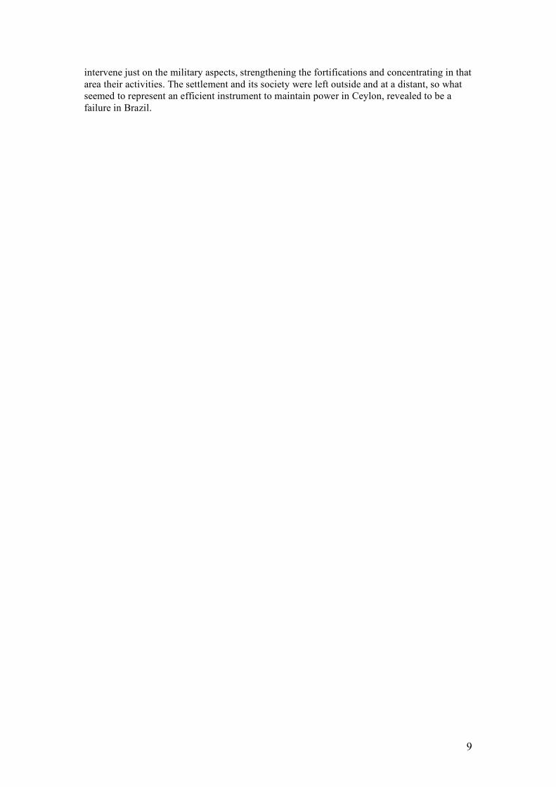
In an map of 1626 by Joao Teixeira Albernaz [fig.1], Olinda is depicted in a triangular shape, probably in order to visualize better that the town was lying on hills, while Recife, at the end of a long small isthmus, protected by some forts and surrounded by a palisade, shows an irregular and organic street pattern10. From 1631 to 1643, and especially during Johan Maurits van Nassau government11, the swampy area of Recife, with its rivers deltas, reefs and sandbars developed from just harbour to the capital of Dutch Brazil12.
6 The convents of the Jesuits and of S. Francisco were standing out on the tops of the town of Olinda, A. BRANDAO, Diálogos das Grandezas do Brasil, Recife, 1997, pp.31-32. An other contemporary description of Olinda: JOHANNES DE LAET, Iaerlyck verhael van de verrichtinghen der Geoctroyeerde West-Indische Compagnie in derthien boecken, 1937, Den Haag, p.190-191. 7 According to Diogo de Campo Moreno (1609) in ‘Relação da praças fortes..’ Olinda was a very difficult city to be fortified, what made it always exposed and vulnerable to attacks, in Revista do Instituto Arqueológico, Histórico e Geográfico Pernambucano, 1984, Recife, p. 200. In his opinion, also Recife was not easy to protect and fortified, Diogo de Campo Moreno, Idem, p. 203. For the Dutch, this flat area surrounded by water, was more suitable to settle. 8 GABRIEL SOARES DE SOUZA, Tratado descritivo do Brasil em 1587, Recife, 2000, p.19. 9 RON VAN OERS, op. cit. Simon Stevin ideal city had been the example for the construction of Bataviam -in Indonesia, seat of the VOC in Asia. Batavia, as main other cities of Dutch design in the tropics, was distinct into Fort and Town area, with in addiction a third area, the kampong, were the indigenous population was relegated. See also the general theories on the urban city in R.F. BETTS (ed. by G. TELKAMP & R. ROSS) Colonial cities: essays on urbanism in a colonial context, Dordrecht, 1985, pp. 231-243, and G. TELKAMP, Urban history and European Expansion: a review of the recent literature concerning colonial cities and a preliminary bibliography, Leiden, 1978, pp. 1-52. In Stevin’s opinion, every city had to be drawn according to the rational principles of the Renaissance, reflecting a spatial and functional internal organisation, in which later the influence and central role of the Western administration could be identify as the ‘colonizer’ mentality, see C. VAN DEN HEUVEL (transl. by), ’De huysbou’: a reconstruction of an unfinished treatise on architecture, town planning and civil engineering by Simon Stevin, Amsterdam 2005. 10 80 people were living inside Portuguese Recife. There was a church and a vigairaria, while on Antonio Vaz, there were just a monastery -later fortified by the Dutch, and some houses spread on the island. See J.L. MOTA MENEZES ‘Olinda e Recife: 1537-1630’ in Oceanos, Janeiro/Marco 2000, nr.41, pp. 136-150. Mota Menezes illustrates the urban foundation and development of Olinda and its harbour Recife during the first Portuguese colonization until the Dutch era. In his opinion the street pattern of Recife, designed by the Portuguese, remained intact during the Dutch domination and despite the general idea, both Recife and Olinda were the results of a plan, inspired by the ideas on urbanism, circulating during the Manueline period in Portugal. 11 From 1637 to 1644. 12 An in-depth study on the maps of Recife, from 1631 to 1648, has been done by J.A. GONCALVES DE MELLO, A cartografia holandesa do Recife: estudo dos principais mapas da cidade, do periodo 1631-1648, Recife 1976, pp. 9-34. On the urban structure and development of Recife see H. VAN NEDERVEEN-MEERKERK, Recife : the rise of a 17th-century trade city from a cultural-historical perspective, Assen 1979 and J.L. MOTA MENEZES, ‘A cidade do Recife. Urbanismo Lusitano e
4
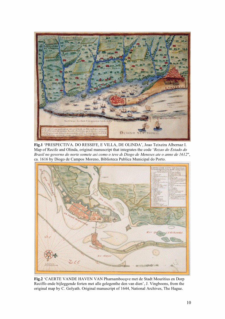
Thanks to the stones and materials left by the destruction of Olinda, the WIC enlarged Recife by winning land on the East and Westside, leaving the street pattern inherited as it was, just defining and regulating the pre-existing situation inside the isthmus. Around 1637 due to the lack of space, overcrowding and prices growth, housing in Recife became such a serious problem that the WIC was forced to consider a plan of urban intervention on Antonio Vaz. On this island, previously fortified, a new town had to be built for administrative and residential purposes. The natural curve of Recife was extended to the opposite island, in the direction of the mainland, and linked, in a successive stage, by a bridge which structure was very innovative at that time. This main axis seaside/hinterland would be ultimately prolonged with a second bridge. Goliath’s map of 1643 [fig.2] shows Mauritsstad at the zenith of its urban development, and now, a hypothetical second axis from north to south is visible, which linked and integrated the civil and military components of the city: the area of the Company with the area of the free-burgers. Mauritsstad’s ground plan was thought and drawn on paper, and thanks to the flat morphology of the location, was nearly perfectly applied. It showed an internal orthogonal and regular pattern, regulated by the two main axes (harbour/mainland, north/south) intersecting with each other, forming perpendicular streets and rectangular blocks of buildings.
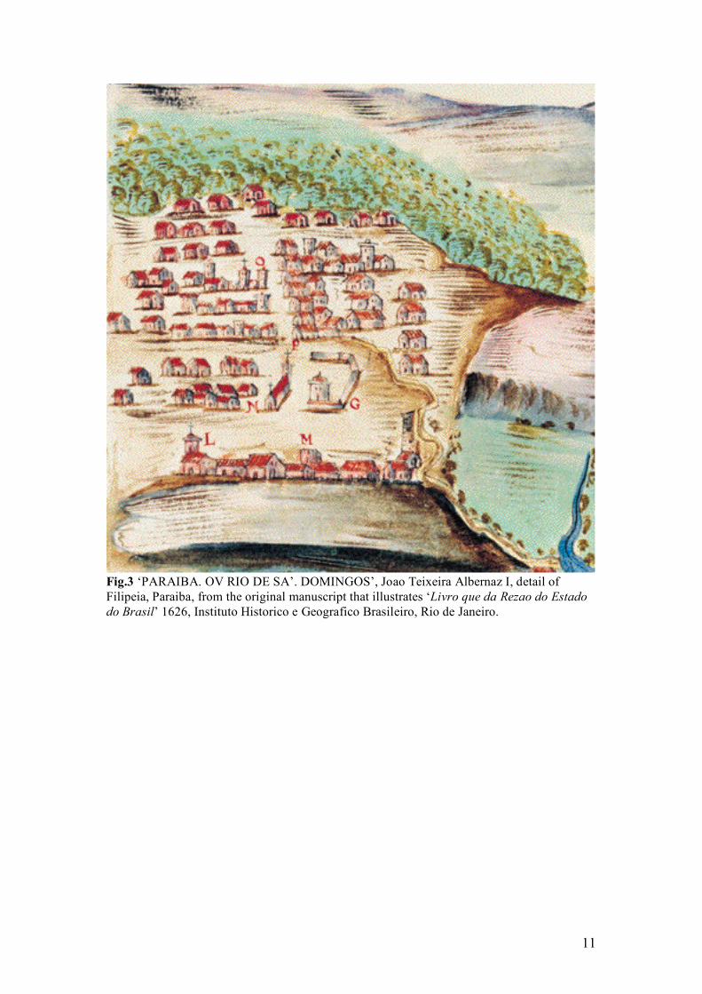
Other settlements like Filipeia or the vilas of Alagoas13, did not change dramatically under Dutch rule; on the contrary, the Dutch tended to preserve the original urban character, affirming their fragile position in Brazil, adapting to the pre-existing centres, strengthening instead the fortifications, or -when necessary-, building new ones. After being conquered by the Dutch (1634), Filipeia’s was a town in the making, but its original urban layout remained mainly intact; in fact maps and descriptions of 1626 [fig.3] and that of the Dutch period [fig.4]14 do not differ much. The settlement, founded in 1588 by Portuguese colonists15, had immediately gained the status of cidade16, belonging the territory of Paraiba to the Crown and not to a donatario. Filipeia’s foundation reveals to be inspired by the urban instruction of the Ordenanzas Filipinas, presenting a regular pattern with its own peculiar aspect lent by the Portuguese tradition17. The town was located on a high point on the right side of the river Paraiba, about 25 km from the river mouth, where some forts were built to defend this fertile area18. According to Herckmans19, Filipeia developed along a main street, the connection between the S. Francisco convent on the eastern side and the sugar plantations in the hinterland. Beautiful dwellings of ‘pedra e cal’ and ‘sobrados’ where the families of the sugar-mills owners lived together with their slaves, were facing this main street (Rua Nova). Holandês’, in Tempo dos Flamengos e outros tempos, Recife, 1999, pp. 213-227. Life in Recife, Olinda and surroundings during the Dutch period has been highly illustrated by J.A. GONCALVES DE MELLO, Nederlanders in Brazilie, 1624-1654, Zutphen, 2001 (translated by B. TEENSMA, orig. version Tempo dos Flamengos: Influencia da ocupação holandesa na vida e na cultura do norte do Brasil, Rio de Janeiro, 1947). 13 The vilas of Alagoas are Penedo, Alagoa do Sul –now Marechal Deodoro- and Porto Calvo. The Portuguese founded these settlements during the first phase of colonization in the 16th century, to ensure their control on a region abundant in cattle and fishery. 14 Description of Diogo de Campo Moreno in 1609 in ‘Relação das praças fortes..’ Revista do IAHGP, 1984, with maps of João Teixeira Albernaz I in 1626. 15 Revista do IAHGP, 1984, p. 193. Those colonists were the owners of sugar plantations and sugar-mills in the surroundings. 16 Literally city; Filipeia, first settlement founded in the capitania of Paraiba, was territory of the united crown of Spain and Portugal, and however small, gained immediately all the rights of a city with a camara (town hall) and a pelourinho for the administration of justice, as was the case of Bahia de todos los Santos and Rio de Janeiro among others. 17 D. ALCANTARA E C. DUARTE ‘O estabelecimento da rede de cidades no Brasil durante o período filipino’ pp. 283-298, in W. ROSSA, H. CARITA, R. ARAUJO, Universo Urbanístico Português 1415-1822, Lisboa, 2000. 18 Forte do Cabedelo, Forte de S. Antonio do Norte, Fortim da Restinga, Forte de Varadouro. 19 E. Herckmans, Beschrijvinge der capitania Paraiba, 1639, NA, OWIC 1.05.01, OBP 46. J. See also J. NIEUHOFF, Gedenkwaerdige zee- en lant-reize door de voornaemste landschappen van West en Oostindien, Amsterdam, 1682, pp. 38-39.
5
Other streets were intersecting this central road, forming blocks with a regular rectangular pattern, where buildings alternated open spaces. Filipeia was in 1634 still under construction and many buildings, like the Franciscan convent, were used as fortifications to house the garrisons. In the middle of town, the main street formed a square where the traditional civic buildings were established (mercado, câmara, pelourinho), while the three convents (S. Francisco, do Carmo e S. Bento) and three churches (a Se, Misericórdia, S. Gonçalo20) of Filipeia were spread through the city area.
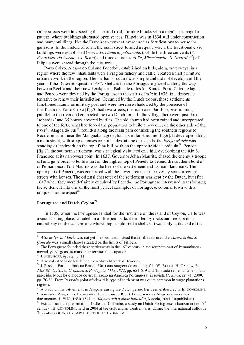
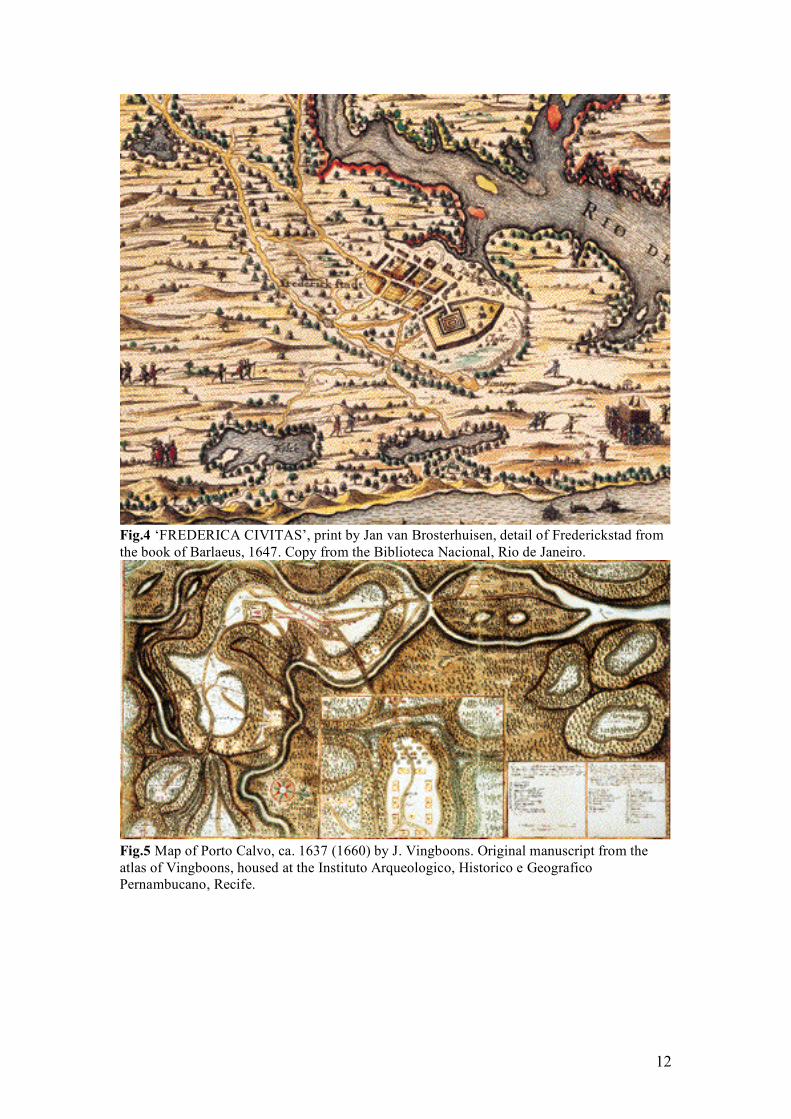
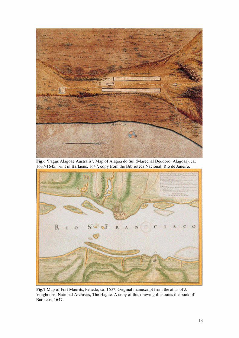
Porto Calvo, Alagoa do Sul and Penedo21, established on hills, along waterways, in a region where the few inhabitants were living on fishery and cattle, created a first primitive urban network in the region. Their urban structure was simple and did not develop until the years of the Dutch conquest in 1637. Shelters for the Portuguese guerrilla along the way between Recife and their new headquarter Bahia de todos los Santos, Porto Calvo, Alagoa and Penedo were elevated by the Portuguese to the status of vila in 1636, in a desperate tentative to renew their jurisdiction. Occupied by the Dutch troops, those settlements functioned mainly as military post and were therefore shadowed by the presence of fortifications. Porto Calvo [fig.5] had two streets, the main one, Sao Jose, was running parallel to the river and connected the two Dutch forts. In the village there were just three ‘sobrados’ and 35 houses covered by tiles. The old church had been ruined and incorporated to one of the forts, what had forced the population to build a new one, on the other side of the river22. Alagoa do Sul23, founded along the main path connecting the southern regions to Recife, on a hill near the Manguaba lagoon, had a similar structure [fig.6]. It developed along a main street, with simple houses on both sides; at one of its ends, the Igreja Matriz was standing as landmark on the top of the hill, with on the opposite side a redoubt24. Penedo [fig.7], the southern settlement, was strategically situated on a hill, overlooking the Rio S. Francisco at its narrowest point. In 1637, Governor Johan Maurits, chased the enemy’s troops off and gave order to build a fort on the highest top of Penedo to defend the southern border of Pernambuco. Fort Maurits was the heart of the settlement and its main landmark. The upper part of Penedo, was connected with the lower area near the river by some irregular streets with houses. The original character of the settlement was kept by the Dutch, but after 1647 when they were definitely expulsed by Penedo, the Portuguese intervened, transforming the settlement into one of the most perfect examples of Portuguese colonial town with a unique baroque aspect25. Portuguese and Dutch Ceylon26
In 1505, when the Portuguese landed for the first time on the island of Ceylon, Galle was
a small fishing place, situated on a little peninsula, delimited by rocks and reefs, with a natural bay on the eastern side where ships could find a shelter. It was only at the end of the
20 A Se or Igreja Matriz was not yet finished, and instead the inhabitants used the Misericórdia. S. Gonçalo was a small chapel situated on the limits of Filipeia. 21 The Portuguese founded these settlements in the 16th century in the southern part of Pernambuco -nowadays Alagoas, to mark their territorial occupation. 22 J. NIEUHOFF, op. cit., p. 11. 23 Also called Vila de Madalena, nowadays Marechal Deodoro. 24 J. Pessoa ‘Forma urban no Brasil - Uma amostragem de casos-tipo’ in W. ROSSA, H. CARITA, R. ARAUJO, Universo Urbanístico Português 1415-1822, pp. 651-659 and ‘Em tudo semelhante, em nada parecido. Modelos e modos de urbanização na América Portuguesa’ in revista Oceanos, nr. 41, 2000, pp. 70-81. From Pessoa’s point of view this type of settlement was quite common in sugar plantations regions. 25 A study on the settlements in Alagoas during the Dutch period has been elaborated in B. CONSOLINI, ‘Impressões Alagoanas, Expressões Holandesas: o Rio S. Francisco e as Alagoas atraves dos documentos da WIC, 1630-1647, in Alagoas sob o olhar holandês, Maceió, 2004 (unpublished). 26 Extract from the presentation ‘Galle and Colombo: a study on Dutch-Portuguese urbanism in the 17th century’, B. CONSOLINI, held in 2004 at the Gulbenkian Centre, Paris, during the international colloque TERRAINS COLONIAUX. ARCHITECTURE ET URBANISME.
6
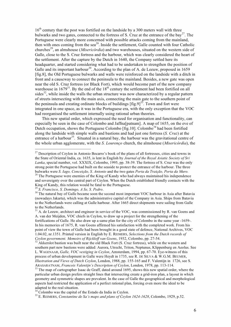
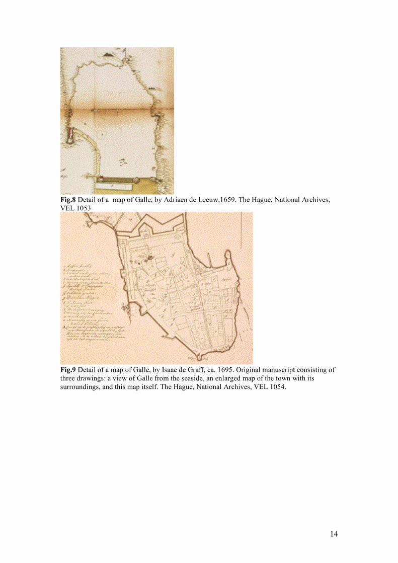
16th century that the post was fortified on the landside by a 300 meters wall with three bulwarks and two gates, connected to the fortress of S. Cruz at the entrance of the bay27. The Portuguese were clearly more concerned with possible attacks coming from the mainland, then with ones coming from the sea28. Inside the settlement, Galle counted with four Catholic churches29, an almshouse (Misericórdia) and two warehouses, situated on the western side of Galle, close to the S. Cruz fortress and the harbour, which was clearly considered the heart of the settlement. After the capture by the Dutch in 1640, the Company settled here its headquarter, and started considering what had to be undertaken to strengthen the position of Galle and its important harbour30. According to the plan of A. de Leeuw, proposed in 1659 [fig.8], the Old Portuguese bulwarks and walls were reinforced on the landside with a ditch in front and a causeway to connect the peninsula to the mainland. Besides, a new gate was open near the old S. Cruz fortress (or Black Fort), which would become part of the new company warehouse in 167931. By the end of the 18th century the settlement had been fortified on all sides32, while inside the walls the urban structure was now characterized by a regular pattern of streets intersecting with the main axis, connecting the main gate to the southern point of the peninsula and creating ordinate blocks of buildings [fig.9]33. Town and fort were integrated in one space, as it was in the Portuguese era, with the only exception that the VOC had reorganised the settlement internally using rational urban theories.
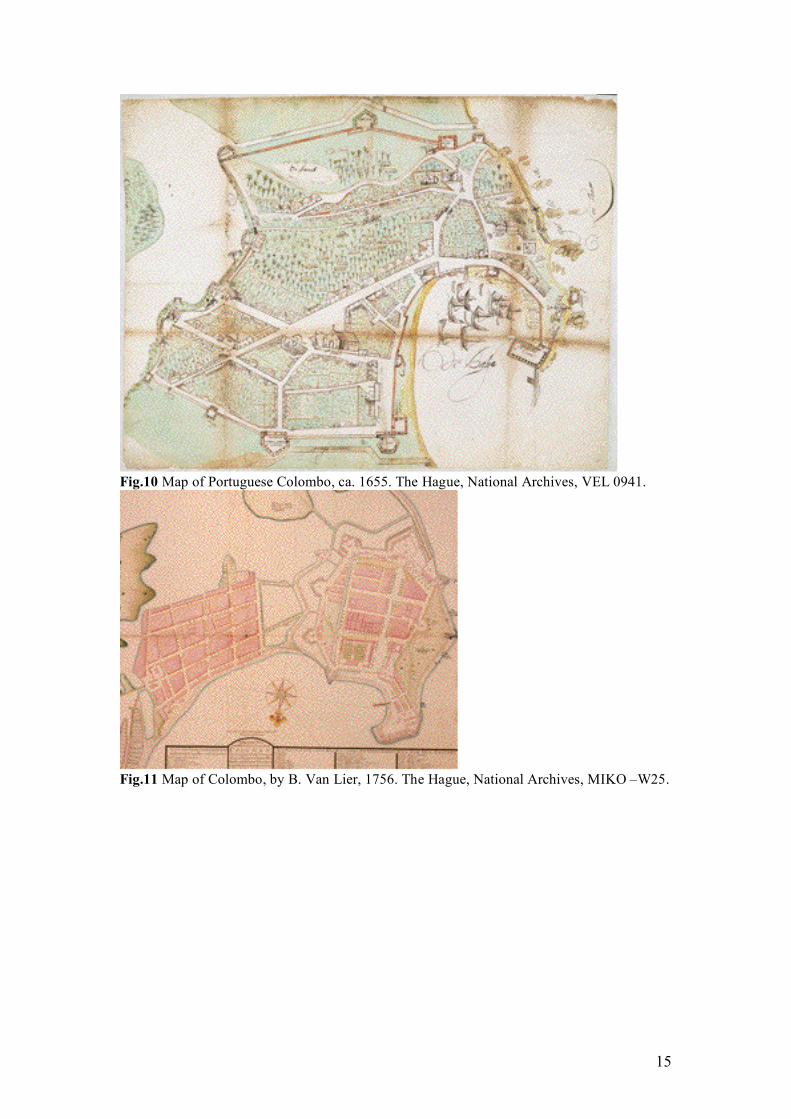
This new spatial order, which expressed the need for organisation and functionality, can especially be seen in the case of Colombo and Jaffna[patnam]. A map of 1655, on the eve of Dutch occupation, shows the Portuguese Colombo [fig.10]. Colombo34 had been fortified along the landside with simple walls and bastions and had just one fortress (S. Cruz) at the entrance of a harbour35. Situated in a natural bay, the harbour was the gravitational centre of the whole urban agglomerate, with the S. Lourenço church, the almshouse (Misericórdia), the 27 Description of Ceylon in Antonio Bocarro’s book of the plans of all fortresses, cities and towns in the State of Oriental India, ca. 1635, is lent in English by Journal of the Royal Asiatic Society of Sri Lanka, special number, vol. XXXIX, Colombo, 1995, pp. 38-39. The fortress of S. Cruz was the only strong point the Portuguese had built on the seaside to protect the entrance of the harbour. The three bulwarks were S. Iago, Conceição, S. Antonio and the two gates Porta da Traição, Porta da Muro. 28 The Portuguese were enemies of the King of Kandy who had always maintained his independence and sovereignty over the central part of Ceylon. When the Dutch established friendly contacts with the King of Kandy, this relation would be fatal to the Portuguese. 29 S. Francisco, S. Domingo, A Se, S. Pedro. 30 The natural bay of Galle became soon the second most important VOC harbour in Asia after Batavia (nowadays Jakarta), which was the administrative capital of the Company in Asia. Ships from Batavia to the Netherlands were calling at Galle harbour. After 1665 direct shipments were sailing from Galle to the Netherlands. 31 A. de Leeuw, architect and engineer in service of the VOC, was commissioned by R. van Goens and A. van der Meijden, VOC chiefs in Ceylon, to draw up a project for the strengthening of the fortifications of Galle. He also draw up a same plan for the city of Colombo in the same year -1659-. In his memories of 1675, R. van Goens affirmed his satisfaction with the completed work. From his point of view the town of Galle had been brought in a good state of defence, National Archives, VOC 1.04.02, nr.1351. Printed version in English by E. REIMERS, Selections from the Dutch records of Ceylon government. Memoirs of Rijckloff van Goens, 1932, Colombo, pp. 27-54. 32 Akkerslot bastion was built near the old Black Fort (S. Cruz fortress), while on the western and southern part new bastions were added: Aurora, Utrecht, Triton, Neptunus, Klippenburg en Aeolus. See L. WAGENAAR, Galle, VOC vestiging in Ceylon, Amsterdam, 1994, pp. 67-70. Eye-witness of this process of urban development in Galle were Heydt in 1735, see R. DE SILVA & W.G.M. BEUMER, Illustration and Views of Dutch Ceylon, London, 1988, pp. 155-165 and F. Valentijn in 1726, see S. ARASARATNAM, Francois Valentijn’s Description of Ceylon, London, 1978, pp. 113-114. 33 The map of cartographer Isaac de Graff, dated around 1695, shows this new spatial order, where the particular urban design prefers straight lines that intersecting create a grid-iron plan, a layout in which geometry and symmetric shapes are prevalent. In the case of Galle the geographical and morphological aspects had restricted the application of a perfect rational plan, forcing even more the ideal to be adapted to the real situation. 34 Colombo was the capital of the Estado da India in Ceylon. 35 E. REIMERS, Constantine de Sa’s maps and plans of Ceylon 1624-1628, Colombo, 1929, p.52.
7
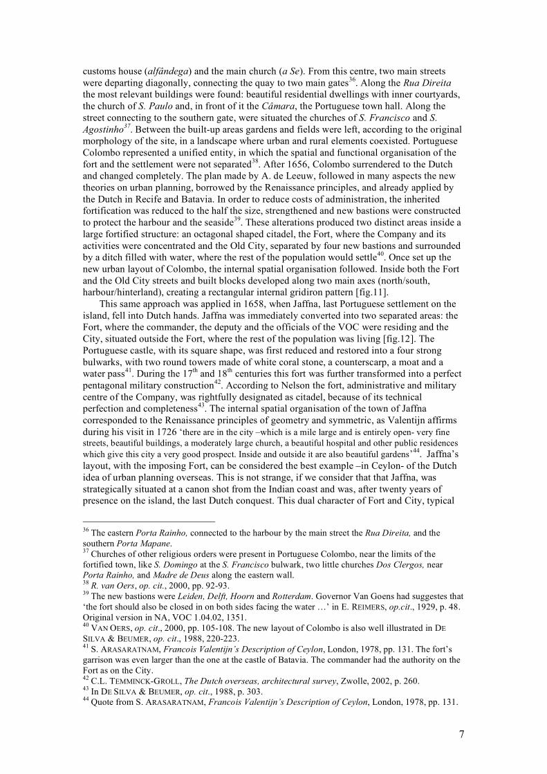
customs house (alfândega) and the main church (a Se). From this centre, two main streets were departing diagonally, connecting the quay to two main gates36. Along the Rua Direita the most relevant buildings were found: beautiful residential dwellings with inner courtyards, the church of S. Paulo and, in front of it the Câmara, the Portuguese town hall. Along the street connecting to the southern gate, were situated the churches of S. Francisco and S. Agostinho37. Between the built-up areas gardens and fields were left, according to the original morphology of the site, in a landscape where urban and rural elements coexisted. Portuguese Colombo represented a unified entity, in which the spatial and functional organisation of the fort and the settlement were not separated38. After 1656, Colombo surrendered to the Dutch and changed completely. The plan made by A. de Leeuw, followed in many aspects the new theories on urban planning, borrowed by the Renaissance principles, and already applied by the Dutch in Recife and Batavia. In order to reduce costs of administration, the inherited fortification was reduced to the half the size, strengthened and new bastions were constructed to protect the harbour and the seaside39. These alterations produced two distinct areas inside a large fortified structure: an octagonal shaped citadel, the Fort, where the Company and its activities were concentrated and the Old City, separated by four new bastions and surrounded by a ditch filled with water, where the rest of the population would settle40. Once set up the new urban layout of Colombo, the internal spatial organisation followed. Inside both the Fort and the Old City streets and built blocks developed along two main axes (north/south, harbour/hinterland), creating a rectangular internal gridiron pattern [fig.11].
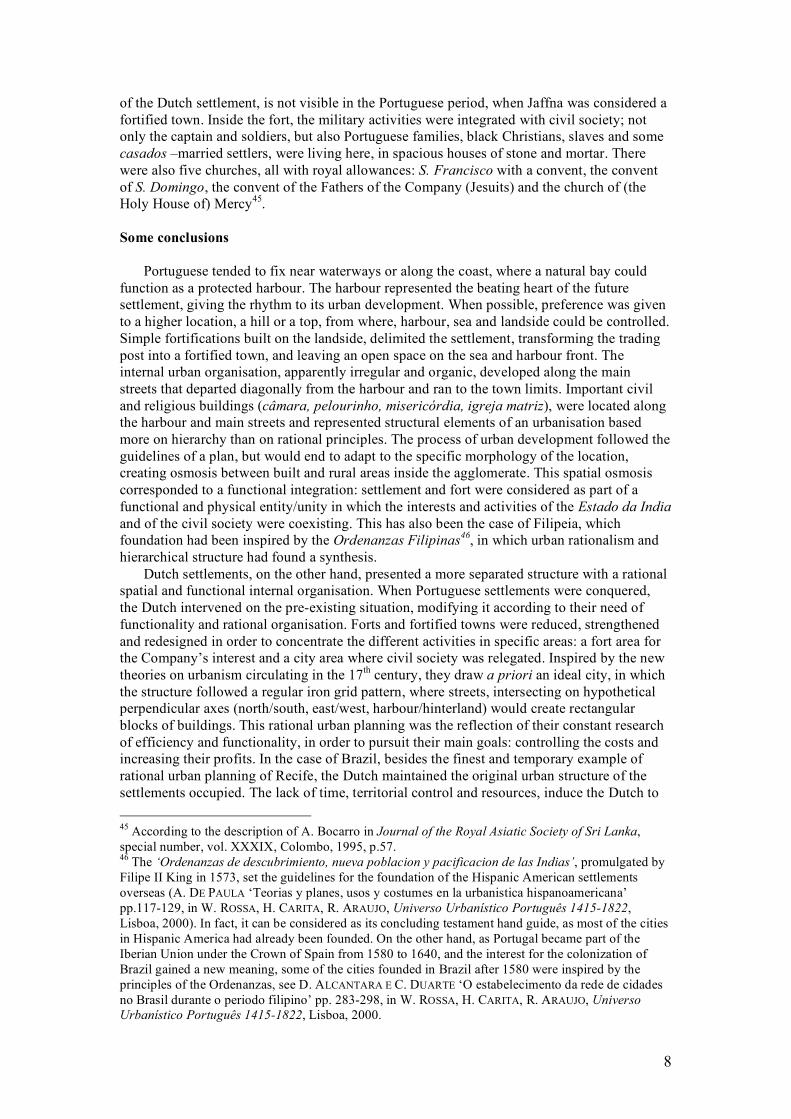
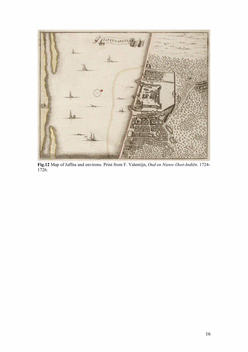
This same approach was applied in 1658, when Jaffna, last Portuguese settlement on the island, fell into Dutch hands. Jaffna was immediately converted into two separated areas: the Fort, where the commander, the deputy and the officials of the VOC were residing and the City, situated outside the Fort, where the rest of the population was living [fig.12]. The Portuguese castle, with its square shape, was first reduced and restored into a four strong bulwarks, with two round towers made of white coral stone, a counterscarp, a moat and a water pass41. During the 17th and 18th centuries this fort was further transformed into a perfect pentagonal military construction42. According to Nelson the fort, administrative and military centre of the Company, was rightfully designated as citadel, because of its technical perfection and completeness43. The internal spatial organisation of the town of Jaffna corresponded to the Renaissance principles of geometry and symmetric, as Valentijn affirms during his visit in 1726 ‘there are in the city –which is a mile large and is entirely open- very fine streets, beautiful buildings, a moderately large church, a beautiful hospital and other public residences which give this city a very good prospect. Inside and outside it are also beautiful gardens’44. Jaffna’s layout, with the imposing Fort, can be considered the best example –in Ceylon- of the Dutch idea of urban planning overseas. This is not strange, if we consider that that Jaffna, was strategically situated at a canon shot from the Indian coast and was, after twenty years of presence on the island, the last Dutch conquest. This dual character of Fort and City, typical
36 The eastern Porta Rainho, connected to the harbour by the main street the Rua Direita, and the southern Porta Mapane. 37 Churches of other religious orders were present in Portuguese Colombo, near the limits of the fortified town, like S. Domingo at the S. Francisco bulwark, two little churches Dos Clergos, near Porta Rainho, and Madre de Deus along the eastern wall. 38 R. van Oers, op. cit., 2000, pp. 92-93. 39 The new bastions were Leiden, Delft, Hoorn and Rotterdam. Governor Van Goens had suggestes that ‘the fort should also be closed in on both sides facing the water …’ in E. REIMERS, op.cit., 1929, p. 48. Original version in NA, VOC 1.04.02, 1351. 40 VAN OERS, op. cit., 2000, pp. 105-108. The new layout of Colombo is also well illustrated in DE SILVA & BEUMER, op. cit., 1988, 220-223. 41 S. ARASARATNAM, Francois Valentijn’s Description of Ceylon, London, 1978, pp. 131. The fort’s garrison was even larger than the one at the castle of Batavia. The commander had the authority on the Fort as on the City. 42 C.L. TEMMINCK-GROLL, The Dutch overseas, architectural survey, Zwolle, 2002, p. 260. 43 In DE SILVA & BEUMER, op. cit., 1988, p. 303. 44 Quote from S. ARASARATNAM, Francois Valentijn’s Description of Ceylon, London, 1978, pp. 131.
8
of the Dutch settlement, is not visible in the Portuguese period, when Jaffna was considered a fortified town. Inside the fort, the military activities were integrated with civil society; not only the captain and soldiers, but also Portuguese families, black Christians, slaves and some casados –married settlers, were living here, in spacious houses of stone and mortar. There were also five churches, all with royal allowances: S. Francisco with a convent, the convent of S. Domingo, the convent of the Fathers of the Company (Jesuits) and the church of (the Holy House of) Mercy45. Some conclusions
Portuguese tended to fix near waterways or along the coast, where a natural bay could function as a protected harbour. The harbour represented the beating heart of the future settlement, giving the rhythm to its urban development. When possible, preference was given to a higher location, a hill or a top, from where, harbour, sea and landside could be controlled. Simple fortifications built on the landside, delimited the settlement, transforming the trading post into a fortified town, and leaving an open space on the sea and harbour front. The internal urban organisation, apparently irregular and organic, developed along the main streets that departed diagonally from the harbour and ran to the town limits. Important civil and religious buildings (câmara, pelourinho, misericórdia, igreja matriz), were located along the harbour and main streets and represented structural elements of an urbanisation based more on hierarchy than on rational principles. The process of urban development followed the guidelines of a plan, but would end to adapt to the specific morphology of the location, creating osmosis between built and rural areas inside the agglomerate. This spatial osmosis corresponded to a functional integration: settlement and fort were considered as part of a functional and physical entity/unity in which the interests and activities of the Estado da India and of the civil society were coexisting. This has also been the case of Filipeia, which foundation had been inspired by the Ordenanzas Filipinas46, in which urban rationalism and hierarchical structure had found a synthesis.
Dutch settlements, on the other hand, presented a more separated structure with a rational spatial and functional internal organisation. When Portuguese settlements were conquered, the Dutch intervened on the pre-existing situation, modifying it according to their need of functionality and rational organisation. Forts and fortified towns were reduced, strengthened and redesigned in order to concentrate the different activities in specific areas: a fort area for the Company’s interest and a city area where civil society was relegated. Inspired by the new theories on urbanism circulating in the 17th century, they draw a priori an ideal city, in which the structure followed a regular iron grid pattern, where streets, intersecting on hypothetical perpendicular axes (north/south, east/west, harbour/hinterland) would create rectangular blocks of buildings. This rational urban planning was the reflection of their constant research of efficiency and functionality, in order to pursuit their main goals: controlling the costs and increasing their profits. In the case of Brazil, besides the finest and temporary example of rational urban planning of Recife, the Dutch maintained the original urban structure of the settlements occupied. The lack of time, territorial control and resources, induce the Dutch to 45 According to the description of A. Bocarro in Journal of the Royal Asiatic Society of Sri Lanka, special number, vol. XXXIX, Colombo, 1995, p.57. 46 The ‘Ordenanzas de descubrimiento, nueva poblacion y pacificacion de las Indias’, promulgated by Filipe II King in 1573, set the guidelines for the foundation of the Hispanic American settlements overseas (A. DE PAULA ‘Teorias y planes, usos y costumes en la urbanistica hispanoamericana’ pp.117-129, in W. ROSSA, H. CARITA, R. ARAUJO, Universo Urbanístico Português 1415-1822, Lisboa, 2000). In fact, it can be considered as its concluding testament hand guide, as most of the cities in Hispanic America had already been founded. On the other hand, as Portugal became part of the Iberian Union under the Crown of Spain from 1580 to 1640, and the interest for the colonization of Brazil gained a new meaning, some of the cities founded in Brazil after 1580 were inspired by the principles of the Ordenanzas, see D. ALCANTARA E C. DUARTE ‘O estabelecimento da rede de cidades no Brasil durante o periodo filipino’ pp. 283-298, in W. ROSSA, H. CARITA, R. ARAUJO, Universo Urbanístico Português 1415-1822, Lisboa, 2000.
9
intervene just on the military aspects, strengthening the fortifications and concentrating in that area their activities. The settlement and its society were left outside and at a distant, so what seemed to represent an efficient instrument to maintain power in Ceylon, revealed to be a failure in Brazil.
10
Fig.1 ‘PRESPECTIVA. DO RESSIFE, E VILLA, DE OLINDA’, Joao Teixeira Albernaz I. Map of Recife and Olinda, original manuscript that integrates the code ‘Rezao do Estado do Brasil no governo do norte somete asi como o teve dı Diogo de Meneses ate o anno de 1612", ca. 1616 by Diogo de Campos Moreno, Biblioteca Publica Municipal do Porto.
Fig.2 ‘CAERTE VANDE HAVEN VAN Pharnambocqve met de Stadt Mouritius en Dorp Reciffo ende bijleggende forten met alle gelegenthe den van dien’, J. Vingboons, from the original map by C. Golyath. Original manuscript of 1644, National Archives, The Hague.
11
Fig.3 ‘PARAIBA. OV RIO DE SA’. DOMINGOS’, Joao Teixeira Albernaz I, detail of Filipeia, Paraiba, from the original manuscript that illustrates ‘Livro que da Rezao do Estado do Brasil’ 1626, Instituto Historico e Geografico Brasileiro, Rio de Janeiro.
12
Fig.4 ‘FREDERICA CIVITAS’, print by Jan van Brosterhuisen, detail of Frederickstad from the book of Barlaeus, 1647. Copy from the Biblioteca Nacional, Rio de Janeiro.
Fig.5 Map of Porto Calvo, ca. 1637 (1660) by J. Vingboons. Original manuscript from the atlas of Vingboons, housed at the Instituto Arqueologico, Historico e Geografico Pernambucano, Recife.
13
Fig.6 ‘Pagus Alagoae Australis’. Map of Alagoa do Sul (Marechal Deodoro, Alagoas), ca. 1637-1645, print in Barlaeus, 1647, copy from the Biblioteca Nacional, Rio de Janeiro.
Fig.7 Map of Fort Maurits, Penedo, ca. 1637. Original manuscript from the atlas of J. Vingboons, National Archives, The Hague. A copy of this drawing illustrates the book of Barlaeus, 1647.
14
Fig.8 Detail of a map of Galle, by Adriaen de Leeuw,1659. The Hague, National Archives, VEL 1053
Fig.9 Detail of a map of Galle, by Isaac de Graff, ca. 1695. Original manuscript consisting of three drawings: a view of Galle from the seaside, an enlarged map of the town with its surroundings, and this map itself. The Hague, National Archives, VEL 1054.
15
Fig.10 Map of Portuguese Colombo, ca. 1655. The Hague, National Archives, VEL 0941.
Fig.11 Map of Colombo, by B. Van Lier, 1756. The Hague, National Archives, MIKO –W25.
16
Fig.12 Map of Jaffna and environs. Print from F. Valentijn, Oud en Nieuw Oost-Indiën. 1724-1726.