Embed Size (px)
Citation preview
Dust storms in Middle Asia: spatial and temporal variations
R. Indoitu, L. Orlovsky & N. Orlovsky
The Jacob Blaustein Institutes for Desert Research, Ben Gurion University of the Negev, Sede Boqer Campus, Israel
Abstract
Dust/sand storms are common events, and one of the most important manifestations of desertification to occur in the arid and semi-arid regions of Middle Asia. Middle Asian deserts are characterized by strong winds, scarcity of vegetation cover, a continental and Mediterranean type of climate with long dry summers, lack of soil moisture and relatively low air moisture, frequent repetition of soil and atmospheric droughts, susceptibility of soils to erosion. Systematic studies of dust storms in the middle Asian region started in the 1930s when “black” and “white” storms increased in frequency. Most of the scientific observations of natural phenomena, including dust storms, in the region ended after the collapse of the USSR, during the 1990s. The main objectives of this study are to monitor and assess the spatial and temporal distribution and activity of dust events over the Middle Asian region. The frequency and spatial distribution of dust storms for three periods of time: 1936-1960, 1936-1980, and 1970-2000 will be shown using meteorological data from almost 500 ground stations and Geographic Information System, (GIS) software. Dust storm activities during these three periods show significant decrease in frequency and considerable changes in the source areas. Temperature and rainfall trends also show significant changes across the region as well as remarkable changes in the annual and inter-annual trends. For the 1936-2000, temperature and rainfall annual trends show three periods of decreases and increases – periods, which correspond to the different atmospheric circulation epochs. This is a future challenge which will be studied in detail. An important goal is to reveal the correlation between the atmospheric circulation patterns (meridional, zonal), synoptic processes and dust storms. Keywords: central Asia, dust storms, source areas, frequency, distribution, seasonality.
Ecosystems and Sustainable Development VII 353
www.witpress.com, ISSN 1743-3541 (on-line)
© 2009 WIT PressWIT Transactions on Ecology and the Environment, Vol 122,
doi:10.2495/ECO090331
1 Introduction
Dust/sand storms are common phenomena that occur in the arid and semi-arid regions of Middle Asia. Middle Asian deserts, like many others, are characterized by strong winds, scarcity of vegetation cover, continental climate with long dry summers, lack of soil moisture, relatively low air moisture, frequent repetition of soil and atmospheric droughts, soil surface more susceptible to erosion [1,2]. The intense problem of soil erosion by strong aeolian activities is mainly accentuated by the vast areas of sandy, solonchak and clayey deserts of natural and anthropogenic origin. Vast areas of natural desert pastures were transformed into cotton fields during the Soviet period, in the 1960s, when a large scale program of irrigated agriculture development took place [3,4]. This led to increase in the frequency of dust storms outbreaks. One of the world's worst ecological disasters, the Aral Sea crisis, resulted in exposure of over 36 000 km2 of the Sea bottom, which became the active source for the dust and salts emission [4,6]. Dust storms transport large amounts of material for long distances and have serious consequences for the environment, farming activities, climate change, disease transmission and air pollution. One concern is that dust storms directly are affecting temperatures and rainfall in the region. The agricultural activities mainly suffer from intensification of salinization process of the soils, mineralization and salinity increase of surface and ground waters, degradation of pastoral vegetation, and decrease of agricultural crops. In Karakalpakstan (Uzbekistan) region the incidence of childhood pneumonia is the highest in the region; in Turkmenistan 50% of all reported illnesses are the respiratory diseases; lung diseases among children are critical in Kazakhstan region. A dust storm starts at a wind speed higher than 7m/s, and it has a strong relation to the soil structure, vegetation cover, drought status, etc. Romanov’s classification (1960) of dust events by visibility states that usually 2-4 km visibility is characteristic for a dust storm. In some areas during a dust storm the visibility can drop down to 1km, sometimes even 10-20m. [3]. A dust storm is considered strong when the wind speed is 10-14 m/s and the visibility is between 500-1000m. A disaster dust storm is characterized by more than 15 m/s wind speed, visibility less than 50 m and duration of 12h and more [2]. There are two types of dust storms characteristic for the region, frontal and local. The frontal dust/sand storms cover huge regions – 100-500km2, while the local develop only on small areas [3]. The main purpose of our work was to give a refined view of temporal variability of dust storms frequency and changes in dust storms source areas within the time. The analyses of diurnal, seasonal and frequency trends have been conducted. While analyzing the climatic conditions such as wind directions, temperatures and precipitations, it is important to assess at what degree each of the factors influence dust storm development. A significant task is to determine the relation between changes in atmospheric circulations epochs and dust storms spatial and temporal variations. We consider atmospheric circulation epochs (meridional, zonal) as significant contributors for dust storm
354 Ecosystems and Sustainable Development VII
www.witpress.com, ISSN 1743-3541 (on-line)
© 2009 WIT PressWIT Transactions on Ecology and the Environment, Vol 122,
development in the region; this could be the major cause of dust storm source areas shifting in space.
2 Study area
The research was conducted in the three Middle Asian countries: Turkmenistan, Uzbekistan and southern Kazakhstan, where the dust storm frequencies are among the highest in the world (up to 146 days per year in southern deserts) [1]. The desert areas of Middle Asia include territories from the shores of the Caspian Sea in the west, up to the foothills of Alatau, Tian Shan, and Pamir-Alay, to the east and south-east. The arid land cover a total area of 1890.2 sq km with human population of almost 40 millions [7]. The Northern border of the study area is defined mostly by the desert’s edge stretching from 48º N latitude in the east and 52ºN in the west. The southern border is defined by the Kopetdag and Paropamiza foothills, 36º N latitude. This wide territory is covered by different desert types: sandy, sandy and pebbles, detritus and gypsum, loessy, clayey and solonchak [5]. Based on variety of synoptic processes, rainfall trends, and annual and interannual trend of temperature, the region is divided into two climatic provinces: northern and southern. The northern province is characterized by cold and dry continental climate, while the southern is characterized by hot and dry continental climate. Mean annual temperatures, for Central Asia, are between 5 and 11ºC in the north province, and 13-16.6ºC in the southern province. The temperatures annual mean minima are registered in January and the maxima in July. The rainfall amount varies between 80-200mm. Less than 100 mm of rainfall were registered in the desert regions of Karakum, Kyzylkum, Betpak-Dala, and western Balkash shore.
3 Materials and methods
Data used in this study covering the period 1936-1960 and 1936-1980 were obtained from the issues of the “Reference Books of the USSR Climate” and the “Scientific and Applied References Book of the USSR”. The data includes the mean of dust storm days per 24 years and 44 years respectively for almost 500 meteorological stations. The repetition means and durations of dust storms events were obtained from same sources. The data covering the years 1980 to 2005 were acquired from the three countries in the region individually and contain the total number of DS days for each month of the year. In addition to this data eighteen meteorological stations from Turkmenistan have the day when a dust storm occurred, with details such as wind direction, wind speed, and DS event duration (h). These measurements were recorded from 1995 until 2005. A data set of meteorological records containing monthly precipitation and mean monthly temperatures were obtained from the National Snow and Ice Data
Ecosystems and Sustainable Development VII 355
www.witpress.com, ISSN 1743-3541 (on-line)
© 2009 WIT PressWIT Transactions on Ecology and the Environment, Vol 122,
Centre (NSIDC) site [8]. The records include data collected at almost 200 stations starting from 1879 to 2003. Remote sensing and GIS methods were used to obtain a detailed analysis of spatial and temporal distribution of dust storm activities, and dust storm source regions shifting.
4 Results
4.1 Seasonal and diurnal trends
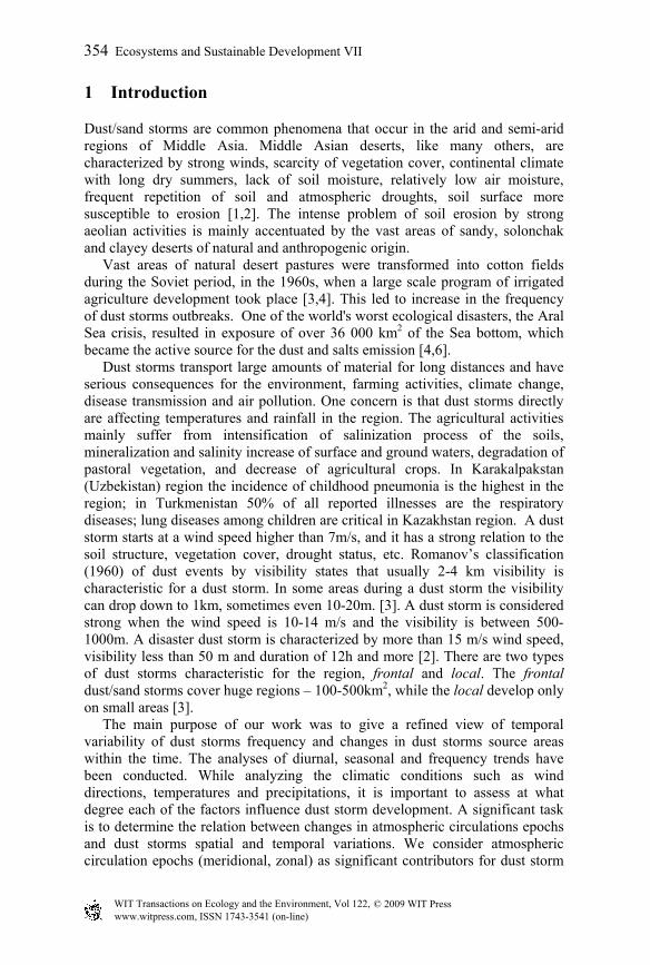
Due to the fact that Middle Asia is an extremely large region of varied geography and climates, dust storm (DS) activities are significantly variable in space and time. DS occur mainly in the spring and summer, but in some regions also in fall. For the majority of the stations the period of the highest DS frequencies was registered in spring (May-June). Annual DS frequency varies over a wide range of 5 to 100 DS days/year, which place the region among the highest DS areas affected in the world. In the Sahel-Sudan region in the 1971-1973 DS occurrences reached more than 80 days a year, in China in the last century the numbers of DS days vary from 10 to 60 per year. Stations in the northern deserts and semi-deserts register the highest annual occurrences of DS in spring and summer (May-September) (fig. 1A), with the maxima in May-June. On the north-eastern shore of Caspian Sea (Guriev, Fort-Shevchenko etc) the season of DS begins in April and lasts until October, even November. In this region the months with maximum number of days with DS are April and May.
Figure 1: Seasonal trend of DS days frequency (A – northern deserts, B – southern deserts).
The numbers of DS days in the southern deserts are far higher than those of the northern deserts; as well the season of DS occurrence is longer. Since the humid season lasts from November to March in the southern deserts, aeolean processes are especially active in spring, summer and autumn (April-October) (fig. 1B). According to Orlovsky et al. [1] in many areas of Turkmenistan dust
0
2
4
6
8
10
12
I II III IV V VI VII VIII IX X XI XII
GurievFort-ShevchenkoAral SeaKyzyl-OrdaChyryc-RabatChelkar
DS
days
/yea
r
month
A
0
1
2
3
4
5
6
7
8
I II III IV V VI VII VIII IX X XI XII
B ErbentTamdyCiagylBukharaBairam-AliRepetek
DS
days
/yea
r
month
356 Ecosystems and Sustainable Development VII
www.witpress.com, ISSN 1743-3541 (on-line)
© 2009 WIT PressWIT Transactions on Ecology and the Environment, Vol 122,
storm occurrence can be registered even in January. For the areas of Central Karakum Desert, March is the beginning of dust storm season, and continues through October.
0
5 0
1 0 0
1 5 0
2 0 0D a s h o g u zC h a rd z o uG a s a n -K u l iD ra v a z aC h e s h m eE r b e n t
4 -5 9 -1 0 1 4 -1 5 1 9 -2 0
DS
recu
rren
ce
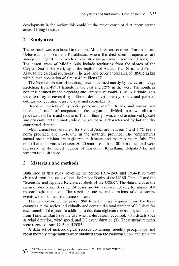
t im e ( h ) Figure 2: Diurnal trend of dust storms over Turkmenistan (1981-1995).
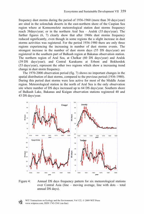
Hourly observations show higher dust frequencies in the midday between 10.00AM and 15.00PM. More than 55% of dust events happen between 9.00AM and 17.00PM. Start times are slightly irregular and specific for each zone, but it is obvious that after 5.00AM DS activities increase. End time of the DS events is even more irregular than the start time (fig. 2). Middle Asian DS can last for hours and even days. However, duration of any event is very irregular, and can be in the range of few tens of minutes up to more than 20 hours. In Turkmenistan the annual mean duration of DS varies significantly depending of location: from 15h in the southwest up to 350h in the west [1]. At most of the stations (fig. 3), in 40-60% of cases dust storms last for 1.5-5.4 hours. More prolonged DS continue between 5.5 and 10h, and present up to 40% of the total during the year. It is obvious (fig. 3) that DS with duration of 5-10h, and higher, occur more frequent in the southern deserts than in the northern. If the average duration of a dust event is more than 10 h then its recurrence significantly decreases. The trend of annual DS frequency in Middle Asia is shown in figure 4, for four stations, and indicates a 5-year moving average of the dust storms with the DS frequency occurring in different periods in various regions. For overall Middle Asia, DS occurrence showed a clear decrease trend with fluctuation over the entire period (1936-2000). For the entire monitoring period there are two marked peaks of DS, occurred in the 1960s and 1980s. For certain areas there is a maximum peak registered between 1940s and 1950s, this trend mainly can be attributed to the southern deserts. At the middle of 1960s the first significant decrease of DS frequency was registered at the large number of observation sites, mainly in the northern deserts. Later on, in the beginning of 1970s, the frequency of days with DS
Ecosystems and Sustainable Development VII 357
www.witpress.com, ISSN 1743-3541 (on-line)
© 2009 WIT PressWIT Transactions on Ecology and the Environment, Vol 122,
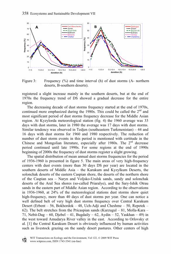
Figure 3: Frequency (%) and time interval (h) of dust storms (A- northern deserts, B-southern deserts).
registered a slight increase mainly in the southern deserts, but at the end of 1970s the frequency trend of DS showed a gradual decrease for the entire region. The decreasing decade of dust storms frequency started at the end of 1970s, continued more emphasized during the 1980s. This could be called the 2nd and most significant period of dust storms frequency decrease for the Middle Asian region. At Kyzylorda meteorological station (fig. 4) the 1960 average was 33 days with dust storms, later in 1980 the average was 17 days with dust storms. Similar tendency was observed in Tedjen (southeastern Turkmenistan) – 44 and 16 days with dust storms for 1960 and 1980 respectively. The reduction of number of dust storm events in this period is mentioned with certitude in the Chinese and Mongolian literature, especially after 1980s. The 2nd decrease period continued until late 1990s. For some regions at the end of 1990s beginning of 2000s the frequency of dust storms register a slight growing. The spatial distribution of mean annual dust storms frequencies for the period of 1936-1960 is presented in figure 5. The main areas of very high-frequency centers with dust events (more than 30 days DS per year) are located in the southern deserts of Middle Asia – the Karakum and Kyzylkum Deserts, the solonchak deserts of the eastern Caspian shore, the deserts of the northern shore of the Caspian sea – Naryn and Voljsko-Uralsk sands, sandy and solonchak deserts of the Aral Sea shores (so-called Priaralye), and the Sary-Ishik Otrau sands in the eastern part of Middle Asian region. According to the observations in 1936-1960, at 24% of the meteorological stations dust storms show quiet high-frequency, more than 40 days of dust storms per year. One can notice a well defined belt of very high dust storms frequency over Central Karakum Desert (Erbent – 56, Bokhordok – 48, Uch-Adji and Cheshme – 50, Repetek – 62). The belt stretches from the Pricaspian sands (Kurzugul – 81, Molla-Kara – 71, Nebit-Dag – 60, Djebel – 41, Bugdaily – 62, Aydin – 52, Yaskhan – 49) in the west toward Amudarya River valley in the east. According to Orlovsky et al. [1] the Central Karakum Desert is obviously influenced by human activities such as livestock grazing on the sandy desert pastures. Other centers of high
0
10
20
30
40
50
60
70
80
<1.5 1.5-5.4 5.5-10.4 10.5-15.4 15.5-20.0 >20.0
A Fort-ShevchenkoGurievKyzyl-OrdaBalkhashBakanasChelkar
freq
uenc
y (%
)
duration (h)
0
10
20
30
40
50
60
<1.5 1.5-5.4 5.5-10.4 10.5-15.4 15.5-20.0 >20.0
B DashoguzErbentBayram-AliBukharaTermezChardzhou
freq
uenc
y (%
)
duration (h)
358 Ecosystems and Sustainable Development VII
www.witpress.com, ISSN 1743-3541 (on-line)
© 2009 WIT PressWIT Transactions on Ecology and the Environment, Vol 122,
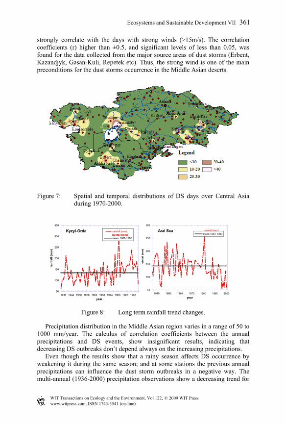
frequency dust storms during the period of 1936-1960 (more than 30 days/year) are sited in the solonchak deserts in the east-northern shore of the Caspian Sea region where at Komsomoletz meteorological station dust storms frequency reach 38days/year; or in the northern Aral Sea – Aralsk (35 days/year). The further figures (6, 7) clearly show that after 1960s dust storms frequency reduced significantly, even though in some regions the a slight increase in dust storms activities was registered. For the period 1936-1980 there are only three regions experiencing the increasing in number of dust storms events. The strongest increase in the number of dust storm days (55 DS days/year) are registered in the southern part of Balkash region at Bakanas observation station. The northern region of Aral Sea, at Chelkar (60 DS days/year) and Aralsk (39 DS days/year); and Central Karakums at Erbent and Bokhordok (53 days/year), represent the other two regions which show a increasing trend change in dust storm frequency. The 1970-2000 observation period (fig. 7) shows no important changes in the spatial distribution of dust storms, compared to the previous period (1936-1980). During this period dust storms were less active for most of the Middle Asian region. Meteorological station in the north of Aral Sea is the only observation site where number of DS days increased up to 64 DS days/year. Southern shore of Balkash Lake, Bakanas and Kuigan observation stations registered 40 and 43 DS days/year.
Figure 4: Annual DS days frequency pattern for six meteorological stations over Central Asia (line – moving average, line with dots – total annual DS days).
0
10
20
30
40
50
60
1939 1949 1959 1969 1979 1989 1999
Ciagyl
DS
(day
s)
year
-20
0
20
40
60
80
100
1939 1949 1959 1969 1979 1989 1999
Jusaly
DS
(day
s)
year
0
10
20
30
40
50
60
70
1939 1951 1963 1975 1987 1999
Kyzyl-Orda
DS
(day
s)
year
0
10
20
30
40
50
60
1939 1951 1963 1975 1987 1999
Tedjen
DS
(day
s)
year
Ecosystems and Sustainable Development VII 359
www.witpress.com, ISSN 1743-3541 (on-line)
© 2009 WIT PressWIT Transactions on Ecology and the Environment, Vol 122,
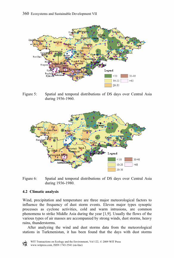
Figure 5: Spatial and temporal distributions of DS days over Central Asia during 1936-1960.
Figure 6: Spatial and temporal distributions of DS days over Central Asia
during 1936-1980.
4.2 Climatic analysis
Wind, precipitation and temperature are three major meteorological factors to influence the frequency of dust storm events. Eleven major types synoptic processes as cyclone activities, cold and warm intrusions, are common phenomena to strike Middle Asia during the year [1,9]. Usually the flows of the various types of air masses are accompanied by strong winds, dust storms, heavy rains, thunderstorms. After analyzing the wind and dust storms data from the meteorological stations in Turkmenistan, it has been found that the days with dust storms
360 Ecosystems and Sustainable Development VII
www.witpress.com, ISSN 1743-3541 (on-line)
© 2009 WIT PressWIT Transactions on Ecology and the Environment, Vol 122,
strongly correlate with the days with strong winds (>15m/s). The correlation coefficients (r) higher than ±0.5, and significant levels of less than 0.05, was found for the data collected from the major source areas of dust storms (Erbent, Kazandjyk, Gasan-Kuli, Repetek etc). Thus, the strong wind is one of the main preconditions for the dust storms occurrence in the Middle Asian deserts.
Figure 7: Spatial and temporal distributions of DS days over Central Asia during 1970-2000.
Figure 8: Long term rainfall trend changes.
Precipitation distribution in the Middle Asian region varies in a range of 50 to 1000 mm/year. The calculus of correlation coefficients between the annual precipitations and DS events, show insignificant results, indicating that decreasing DS outbreaks don’t depend always on the increasing precipitations. Even though the results show that a rainy season affects DS occurrence by weakening it during the same season; and at some stations the previous annual precipitations can influence the dust storm outbreaks in a negative way. The multi-annual (1936-2000) precipitation observations show a decreasing trend for
50
100
150
200
250
300
350
1938 1944 1950 1956 1962 1968 1974 1980 1986 1992
Kyzyl-Orda rainfall (mm)
mean 1961-1990rainfall trend
rain
fall
(mm
)
year
50
100
150
200
250
300
1940 1950 1960 1970 1980 1990 2000
Aral Seamean 1961-1990rainfall trend
rain
fall
(mm
)
year
Ecosystems and Sustainable Development VII 361
www.witpress.com, ISSN 1743-3541 (on-line)
© 2009 WIT PressWIT Transactions on Ecology and the Environment, Vol 122,
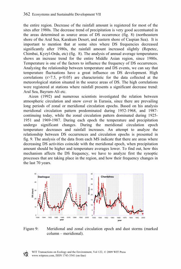
the entire region. Decrease of the rainfall amount is registered for most of the sites after 1980s. The decrease trend of precipitation is very good accentuated in the areas determined as source areas of DS occurrence (fig. 8) (northeastern shore of the Aral Sea, Karakum Desert, and eastern shore of Caspian Sea). It is important to mention that at some sites where DS frequencies decreased significantly after 1980s, the rainfall amount increased slightly (Repetec, Chimbai, Kyzyl-Orda, etc) (fig. 8). The analysis of annual average temperatures shows an increase trend for the entire Middle Asian region, since 1980s. Temperature is one of the factors to influence the frequency of DS occurrences. Analyzing the relationship between temperature and DS events, we can say that temperature fluctuations have a great influence on DS development. High correlations (r>7.5, p<0.05) are characteristic for the data collected at the meteorological station situated in the source areas of DS. The high correlations were registered at stations where rainfall presents a significant decrease trend: Aral Sea, Bayram-Ali etc. Aizen (1992) and numerous scientists investigated the relation between atmospheric circulation and snow cover in Eurasia, since there are prevailing long periods of zonal or meridional circulation epochs. Based on his analysis meridional circulation pattern predominated during 1952-1968, and 1987-continuing today, while the zonal circulation pattern dominated during 1925-1951 and 1969-1987. During each epoch the temperature and precipitation undergo significant changes. During the meridional circulation epoch temperature decreases and rainfall increases. An attempt to analyze the relationship between DS occurrences and circulation epochs is presented in fig. 9. The analysis of the data from each MS indicate that there are areas where decreasing DS activities coincide with the meridional epoch, when precipitation amount should be higher and temperature averages lower. To find out, how this mechanism affects the DS frequency, we have to analyze first the synoptic processes that are taking place in the region, and how their frequency changes in the last 70 years.
Figure 9: Meridional and zonal circulation epoch and dust storms (marked column – meridional).
0
10
20
30
40
50
1936 1944 1952 1960 1968 1976 1984 1992 2000
Dashoguz
DS
(day
s)
year
0
5
10
15
20
25
30
35
40
1936 1944 1952 1960 1968 1976 1984 1992 2000
Chardzhou
DS
(day
s)
year
362 Ecosystems and Sustainable Development VII
www.witpress.com, ISSN 1743-3541 (on-line)
© 2009 WIT PressWIT Transactions on Ecology and the Environment, Vol 122,
5 Conclusions
Analysis of data on dust storms for the last seventy years demonstrates the clear downward trend of dust storm frequency in Middle Asia. The significant decreasing trend is most obvious over the Karakum Desert where DS occurrences reduced from an average of 30 days per year to less than 20 days per year. At Erbent station, one of the major source areas of dust storms, number of days with DS before 1980s could reach an average 60 days, while in recent two decades the amount of DS days was registering an average of less than 20 days per year. Spatial distribution maps suggest four main source areas of dust storm occurrence, which during the time suffered changes as shifting and shrinking their spots. The main spatial changes are obvious in the Northern Caspian deserts, where DS occurrence areas shrunk significantly, and also suffered a few hundred kilometers shift to the east. The Karakum and Kyzylkum Deserts and south Balkash area suffered important surface reduction of the major source areas of DS activities. Analysis of the long-term meteorological data in the Middle Asian region revealed the clearly expressed increasing trend in temperatures and decreasing precipitation trend (especially after 1980s) in the areas with high DS activity. Central Karakum desert, Aral Sea region, North Caspian and south Balkash shores present the most significant changes in the two climatic factors: increasing temperatures and decreasing rainfall trends. Decreasing dust storm frequency could be possibly explained by recovery of desert ecosystems due to reduced anthropogenic activities. The other possible reason may be the changes of atmospheric circulation patterns every 10-20 years. These causes are in process of a detailed analysis, using satellite imagery and synoptic data.
References
[1] Orlovsky L., Orlovsky, N., Durdiev, A. Dust storms in Turkmenistan. Journal of Arid Environments; 60 (83-97).2005
[2] Dedova T. V., Semeonov, O.F., Tuseeva, N.B. Division of Kazakhstan territory by the repetition of very strong dust storms, and based on meteorological observations, remote sensing images and GIS (in Russian). 2006.
[3] Tolkacheva G. A. Long term ecological research program for monitoring Aeolian soil erosion in Central Asia (in Russian). Hydro-meteorological Institute, Tashkent, 2007.
[4] Wiggs G. F., O'Hara, S.L., Wegerdt, J., Van Der Meer, J., Small, I., Hubbard, R. The dynamics and characteristics of aeolian dust in dryland Central Asia: possible impacts on human exposure and respiratory health in the Aral Sea basin. The Geographical Journal; 169 (2):142-57.2003
[5] Jumashov A. P. Ecological and geographical conditions of desert types in Central Asia (Эколо-географические условия и типы пустынь Средней Азии) (in Russian), 1990.
Ecosystems and Sustainable Development VII 363
www.witpress.com, ISSN 1743-3541 (on-line)
© 2009 WIT PressWIT Transactions on Ecology and the Environment, Vol 122,
[6] Galaeva O. S., Idrysova, V.P. Climatic characteristics of dust storms in Circum-Aral region (Kлиматические особенности пыльнх бурь приаралья). Scientific articles, Hydrometeorology and Ecology.2007
[7] Rachkovskaya E. I., Volkova, E.A., Khramtsov, V.N. Botanical Geography of Kazakhstan and Middle Asia (Desert Region). BOOK:26-8.2003
[8] Williams M. W., Konovalov, V.G. Central Asia Temperature and Precipitation Data, 1879-2003. Boulder, Colorado: USA National Snow and Ice Data Center. Digital media., 2008.
[9] Yanagamova S. I., Mukhrarov, T. M., Mukhtarov, Sh. T. The peculiarities of synoptic processes of Central Asia (Особенности синоптических процессов Седней Азии) (in Russian), 2002.
364 Ecosystems and Sustainable Development VII
www.witpress.com, ISSN 1743-3541 (on-line)
© 2009 WIT PressWIT Transactions on Ecology and the Environment, Vol 122,