Embed Size (px)
DESCRIPTION
Discovery Park Local Area Structure Plan
Citation preview

Discovery ParkLOCAL AREA STRUCTURE PLAN
LEDUC COUNTY
Prepared for:Remington Development Corp.Prepared by:Focus Corporation
102344-10February 2011

Discovery Park Local Area Structure Plan
Page i of 51
1.0 INTRODUCTION 3 1.1 Vision ................................................................................................................................................ 3 1.2 Purpose............................................................................................................................................. 3 1.3 Local Area Structure Plan Objectives ............................................................................................... 3 1.4 Background....................................................................................................................................... 4 1.5 Public Consultation ........................................................................................................................... 6
2.0 DEVELOPMENT AREA 8 2.1 Location and Context ........................................................................................................................ 8 2.2 Legal Descriptions and Ownership ................................................................................................... 8 2.3 Queen Elizabeth II Highway Realignment......................................................................................... 8 2.4 Pipelines ........................................................................................................................................... 9 2.5 Topography and Vegetation.............................................................................................................. 9 2.6 Soils and Groundwater...................................................................................................................... 9 2.7 Significant Environmental Features ................................................................................................ 10 2.8 Biophysical Significance.................................................................................................................. 10 2.9 Archaeological Significance ............................................................................................................ 11
3.0 POLICY CONTEXT 15 3.1 General ........................................................................................................................................... 15 3.2 Municipal Government Act .............................................................................................................. 15 3.3 Capital Region Growth Plan............................................................................................................ 15 3.4 Municipal Development Plan........................................................................................................... 16 3.5 Leduc County Statutory Planning Documents................................................................................. 17 3.6 Leduc County Land Use Bylaw No. 7-08 ........................................................................................ 17 3.7 Highway 2 Corridor Design Guidelines ........................................................................................... 17 3.8 Leduc County North Major Area Structure Plan (Bylaw No. 25-05) ................................................ 17 3.9 Edmonton International Airport Area Structure Plan and Implementation Plan............................... 17 3.10 Edmonton International Airport Vicinity Protection Area Regulation (Alta. Reg. 55/2006) .............. 18 3.11 TP 1247, Land Use in the Vicinity of Airports.................................................................................. 18 3.12 Edmonton International Airport Diverge Area and Inclination Profile .............................................. 19 3.13 Approach Lighting Right-of-Way ..................................................................................................... 19
4.0 DEVELOPMENT CONCEPT 22 4.1 General ........................................................................................................................................... 22 4.2 Land Use Objectives ....................................................................................................................... 22 4.3 Land Uses....................................................................................................................................... 22 4.4 Parks............................................................................................................................................... 23 4.5 Queen Elizabeth II Highway Transitional Policy Area ..................................................................... 24
5.0 TRANSPORTATION 28 5.1 General ........................................................................................................................................... 28 5.2 Transportation Objectives ............................................................................................................... 28 5.3 Access ............................................................................................................................................ 28 5.4 Traffic Impact Assessment.............................................................................................................. 28 5.5 Roadways ....................................................................................................................................... 29 5.6 Pedestrian and Cycling Linkages.................................................................................................... 31 5.7 Park and Ride ................................................................................................................................. 31
6.0 SERVICING 34 6.1 General ........................................................................................................................................... 34 6.2 Servicing Objectives........................................................................................................................ 34 6.3 Water Servicing............................................................................................................................... 34 6.4 Sanitary Sewer................................................................................................................................ 35 6.5 Stormwater Management................................................................................................................ 35 6.6 Low-Impact Development ............................................................................................................... 36

Discovery Park Local Area Structure Plan
Page ii of 51
6.7 Shallow Utilities............................................................................................................................... 37 6.8 Emergency Response Services ...................................................................................................... 37
7.0 IMPLEMENTATION 42 7.1 General ........................................................................................................................................... 42 7.2 Zoning ............................................................................................................................................. 42 7.3 Development Staging...................................................................................................................... 42 7.4 Cost Sharing ................................................................................................................................... 42 7.5 Amendments to the Plan................................................................................................................. 42 7.6 Development Guidelines ................................................................................................................. 43
8.0 POLICY SUMMARY 47 9.0 REFERENCES 51 List of Figures Figure 1– Location within Leduc County ........................................................................................................... 12 Figure 2 – Ownership Plan ............................................................................................................................... 13 Figure 3 – Opportunities and Constraints ......................................................................................................... 14 Figure 4 – Municipal Development Plan ........................................................................................................... 20 Figure 5 – Edmonton International Airport Stormwater Management Zones .................................................... 21 Figure 6 – Development Concept Plan ............................................................................................................. 26 Figure 7– Policy Areas...................................................................................................................................... 27 Figure 8 – Mobility Plan .................................................................................................................................... 32 Figure 9 – Pedestrian Circulation...................................................................................................................... 33 Figure 10 – Water Servicing Plan ..................................................................................................................... 39 Figure 11– Sanitary Servicing Plan................................................................................................................... 40 Figure 12 – Stormwater Servicing Plan............................................................................................................. 41 Figure 13 – Development Staging .................................................................................................................... 46

Discovery Park Local Area Structure Plan
Page 3 of 51
1.0 INTRODUCTION 1.1 Vision Discovery Park is envisioned as a hub of logistics, distribution, and related businesses supported by commercial uses geared to expand and diversify the industry, commerce and trade activity in Leduc County. Due to the international access provided by the Edmonton International Airport, the Plan area’s proximity to the City of Edmonton, the promotion of Port Alberta and its location as a gateway to northern oil exploration, Discovery Park is positioned to become a key development in the future growth of the Capital Region. The development of Discovery Park in the manner outlined in this Plan is in line with the Aerotropolis concept that Leduc County is supporting. The proposed uses within the Plan area will accommodate the business, industry and services desired for the Aerotropolis concept with a variety of parcel sizes and an efficient transportation network to ensure effective and productive use of the Plan area. The business opportunities created within Discovery Park will support the employment of the residents who reside within close proximity to the Plan area now and into the future. The Plan area proposes a day-use park and can function as an employee amenity, providing opportunities for socialization and recreation. Future surrounding residential land uses will also benefit from the location of the day-use park in the northeast corner of the plan area. Development of the Plan area will serve as a catalyst for any and all future servicing and development west of the Queen Elizabeth II Highway in Leduc County. In addition, Discovery Park’s focus on the environment and enhanced architectural requirements will no doubt be the benchmark for neighbouring developments. Development of individual lots will be guided by a set of Development Guidelines within this document to ensure there is a level of cohesiveness and quality in the overall design and lot layouts. Discovery Park will endeavour to limit its environmental impact through the integration of Low-Impact Development (LID) principles. LID is an approach to stormwater management that strives to mimic natural processes in an effort to distribute infiltration and reuse stormwater rather than providing artificial, point-source treatment. Individual sites will be encouraged to utilize LID principles. 1.2 Purpose The Discovery Park Local Area Structure Plan (LASP) describes how ± 262 hectares of farmland located north of Highway 19 and west of the Queen Elizabeth II Highway in Leduc County will be developed into an efficient and orderly Business Park with a Commercial and Logistics and Distribution area. The LASP has been prepared on behalf of Remington Development Corporation and Capital Corridor Developments, who collectively own the majority of land within the Plan area.
The purpose of this document is to provide a framework to guide the development of Discovery Park. This Plan will address planning issues in a comprehensive manner to effectively coordinate servicing and transportation infrastructure with the spatial organization of land uses. Additionally, this Plan seeks to introduce policy and guidelines that will create a successful and environmentally responsible development. 1.3 Local Area Structure Plan Objectives The Discovery Park LASP has the following objectives:
1. To create a comprehensive plan that describes appropriate development within the plan area; 2. To provide a policy framework that guides development within the plan area;

Discovery Park Local Area Structure Plan
Page 4 of 51
3. To identify land uses that meet the needs of the development concept; 4. To detail a development concept that complements and diversifies the regional economic market and is
acceptable to local residents; 5. To provide diversification of development from pre-existing development within Leduc County. 6. To illustrate the physical characteristics of the plan area and describe any physical impact on the
natural environment by the proposed development, including strategies to mitigate environmental impacts;
7. To identify any constraints to the plan area and how these will be addressed within the proposed development;
8. To determine development guidelines for land uses within the plan area; 9. To provide a Gateway to the Capital Region along the Queen Elizabeth II Highway corridor; 10. To address the servicing, transportation and open space requirements associated with the proposed
development; and 11. To ensure compatibility with the policies and objectives of Alberta Transportation and the Edmonton
International Airport within the Discovery Park development area. 1.4 Background Discovery Park is uniquely located to provide an opportunity to connect to existing and projected development related to transport and trade. 1.4.1 Locational Advantage
The Discovery Park lands are located less than four kilometres from the City of Edmonton limits, directly north across Highway 19 from the Edmonton International Airport and directly west across the Queen Elizabeth (QE) II Highway from Nisku. As such, this location provides a logical next step in further industrial and commercial expansion between existing development within Leduc County and the City of Edmonton and will play a key role in the economic diversification of the area. The services provided there would complement those available in the City of Edmonton, Nisku and the Edmonton International Airport. The location is ideal due to its accessibility by automobile via the QE II and Highway 19 and the anticipated public transportation planned for the area. The Discovery Park Plan area is in close proximity to the East Vistas development area east of the Queen Elizabeth II which has been planned for approximately 22,000 residents, who will be within less that 5 kilometres from the employment opportunities created within Discovery Park. Future residential expansion within the surrounding area has been identified by Leduc County directly to the west of the Discovery Park area, which has been estimated to house an additional 28,000 residents. The creation of jobs within the Discovery Park area will provide employment opportunities for residents within Leduc County who will live within close commuting distance to the Plan area.
1.4.2 Oil and Gas Production
Oil and gas production has been, and continues to be, of crucial importance to the economies of Alberta and Canada. The history of the extraction and processing of this natural resource goes back to 1947, when the drill site, Leduc No. 1 was discovered. This discovery propelled Alberta’s economy from one of agricultural production to an oil-driven employment boom.

Discovery Park Local Area Structure Plan
Page 5 of 51
In 1963, Great Canadian Oil Sands capitalized upon the potential of the oil deposits in the Athabasca region and a decade later Syncrude began to produce synthetic crude oil from extracted bitumen. These beginnings were to become the incubator for one of the world’s most influential economic regions.
As of August 2009, there were 91 active oil sands projects in Alberta (Government of Alberta, July 2010). There are an estimated total of 171.8 billion barrels of potentially recoverable oil in the oil sands (Government of Alberta, July, 2010). It is estimated that every dollar invested in the oil sands creates approximately $9 worth of economic activity globally and $6 in direct and indirect activity in the Alberta economy (Government of Alberta, September 2008). With a projected investment of over $100 billion in the oil sands industry until 2020 and with new pipeline construction proposed to the Arctic, opportunities within the Port Alberta Region are favourable (Canadian Energy Research Institute, 2005).
The capital region is situated as the gateway to the oil-producing north. Discovery Park is ideally located within this gateway to provide opportunities for the development of new business ventures to support oil-related activities.
1.4.3 Nisku Industrial Park
Today, Nisku is a centre of diversified industry. Energy sector companies remain in the majority of businesses that are located within Nisku, including pipefitters, welders, oil rig builders, etc. More recently, manufacturing and service industries have been increasing in number, creating new types of employment and giving the community a broader industrial base. As the Edmonton International Airport continues to expand, there has been increased demand for logistics and distribution based businesses within Nisku and the surrounding area. Additionally, there has been an increase in international interest within the Nisku area due to increased international connectivity through the Edmonton International Airport, value added services associated with Port Alberta and the close proximity to the Northern oil sands and local oil extraction projects. The existing Nisku area presently has capacity for new development and redevelopment of the present type of industrial land use. However, this area is unable to satisfy the growing demand for corporations to amalgamate their multiple site locations to one comprehensive site capable of accommodating a variety of uses such as offices and light industrial components within a campus like setting. These users are demanding a broader range of uses and higher aesthetic standards, with more strictly controlled development guidelines. Discovery Park is in an ideal location to fulfill this need, and is intended to fulfill Leduc County’s vision of more aesthetically appealing development.
1.4.4 Port Alberta
Port Alberta is staged to become a gateway for cargo transportation combining air, rail, and road transportation infrastructure at a single location at the Edmonton International Airport (EIA). The EIA is Canada’s fastest growing (by passenger) and second largest (by area) major airport in Canada (Edmonton Airports, June 2007). The EIA is surrounded by enough land to accommodate Port Alberta and is strategically located at the crossroads of air, road, rail and shipping transportation routes.
The Capital Region’s rail network is extensive, reliable and cost-effective. Petroleum and chemicals, grain, fertilizers, coal, metals and minerals, forest products and automotive shipments are all transported quickly and efficiently on more than 8,000 kilometers of Alberta rail, linking the resource-rich north through mainline service to points west, south and southwest across the continent.

Discovery Park Local Area Structure Plan
Page 6 of 51
Port Alberta will serve as the prime service centre for northern resource development, the major distribution point for key North American centers and the direct rail connection to the Port of Prince Rupert. Port Alberta offers excellent long-term prospects and significant cost and time advantages without international cross-border movement. The Edmonton International Airport is in a position to optimize its strategic location to fully capture market potential and to reinforce its position as part of the inter-modal transportation network of supplies and services to the north and of air cargo exports to global markets.
Within this context, it is clear that the development of Discovery Park with its Business Park and Logistics and Distribution uses, provides an attractive opportunity and a prime location for future light industrial and business opportunities to support and sustain Port Alberta. Discovery Park’s proximity to the International Airport as well as to surrounding industrial development and road and rail infrastructure will make it an attractive choice for many businesses.
1.4.5 Aerotropolis Principles
The Edmonton International Airport is currently expanding its international terminal, which will contribute to the role that the airport plays in providing connectivity between Northern Alberta and the rest of the world. As the number of flights increases, so does the demand for services required by passengers within and around the airport. The airport is one of the key economic drivers for industry development to the north and the main portal for bringing newcomers to this area from other parts of the world. Leduc County is aiming to support and capitalize on the EIA growth by extending its functions past the terminals to provide a variety of “outside fence” broader Aerotropolis uses such as goods processing, logistics and distribution services, office and business services, and retail among others. One of the ways they are aiming to accomplish this is through the implementation of the Aerotropolis concept. The Aerotropolis concept consists of an airport city and outlying corridors with clusters of aviation-linked businesses and associated residential development. This concept has been successfully implemented around many large international airports around the world. Major airports can attract aviation-linked businesses of which can include, among others, industrial parks; time-sensitive manufacturing and distribution; hotel, entertainment, retail, convention, trade and exhibition complexes; and office buildings that house air-travel intensive executives and professionals. An Aerotropolis is intended to provide a destination for local residents to utilize for their personal retail and service needs as well as provide opportunities for logistics, distribution and passenger services.
The Discover Park Plan area, which includes a Business Park component and a Logistics and Distribution Overlay area, is positioned perfectly to contribute to the functionality of the Aerotropolis. By providing opportunities for businesses, services and industries that will complement the function of the airport’s extensive transportation network, this area will support Aerotropolis principles.
1.5 Public Consultation On August 18, 2010 from 6:00 pm to 8:00 pm an Open House was held for the Discovery Park Local Area Structure Plan in Ballroom III of the Nisku Inn, in Nisku, Alberta. The Open House was advertised for two consecutive weeks prior, in local newspapers: The Edmonton Journal, The Pipestone Flyer and The Leduc Representative. Approximately 38 individuals from the public attended this meeting. A number of others were in attendance including Leduc County staff, Leduc County Councillors, Remington Development Corporation staff, Capital Corridor Investments staff, and Focus Corporation staff.

Discovery Park Local Area Structure Plan
Page 7 of 51
From the public attendees, a total of seven comment sheets were competed and returned. All respondents were either area residents or had business interests within the Plan area. A questionnaire was provided to the public attendees and all respondents were either area residents or had business interests within the plan area. A question about general support for the LASP on a scale of 1(low) to 5 (high) was asked, to which 14% responded 1/5, 14% responded 2/5, 14% responded 3/5, another 14% responded 4/5 and 44% responded 5/5. It can be clearly said that the majority of the respondents were in support of the proposed Plan. No changes will be made to the Discovery Park LASP as a result of the Public Open House.

Discovery Park Local Area Structure Plan
Page 8 of 51
2.0 DEVELOPMENT AREA 2.1 Location and Context Discovery Park is located adjacent to the Queen Elizabeth II Highway within Leduc County and is approximately 4 kilometres from the municipal boundary of the City of Edmonton (see Figure 1 – Location Plan). The lands surrounding the Plan area are as follows: • North – forested and agricultural land; • East - Queen Elizabeth II Highway with Nisku Business Park, beyond; • South - Highway 19 with Edmonton International Airport, beyond; and • West - Range Road 252 with agricultural land, beyond. Transportation upgrades are proposed for Highway 19 and adjacent service roads, in addition to the construction of a future interchange of Highway 19 and the Queen Elizabeth II Highway. These improvements will impact the Plan area along the south and east boundaries.
Proximity to the Edmonton International Airport means that the subject lands are situated directly under the flight path of a runway located south of the Plan area. As such, Discovery Park will be subject to the development restrictions of the Edmonton International Airport Vicinity Protection Area Regulation. Transport Canada and NAV Canada policies and regulations will also apply. The relevant regulations are defined in Section 3 – Policy Context of this document. 2.2 Legal Descriptions and Ownership Lands within the ± 262 hectare Plan area are owned by four different property owners. See Figure 2- Ownership Plan. The majority of the Plan area, a total of 194 hectares, is owned by the Remington Development Corporation. A summary of property ownership is provided in the table below:
Table 1 – Property Ownership 2.3 Queen Elizabeth II Highway Realignment It is anticipated that the future right-of-way of the Queen Elizabeth II is indicated on Figure 8 – Mobility Plan and will affect approximately 48 hectares of developable land within the Plan area (see Figure 7 – Policy Areas).
Property Ownership Legal Description Owner Certificate of
Title Area (ha)
1) SW ¼; 35;50;25;4 Remington Development Corp. 072 396 318 64.928 2) NW ¼; 26;50;25;4 Remington Development Corp. 072 169 983 64.958 3) NE ¼; 26;50;25;4 Remington Development Corp. 072 267 113 11.492 4) Block A; Plan 8821332 Remington Development Corp. 072 726 851 53.355 5) SE ¼; 35;50;25;4 Capital Corridor Developments Ltd. 072 652 902 52.024 6) Lot A; Plan 896 NY Private Ownership 042 486 769 +8 12.369 7) Lot 1, Block 1; Plan 072 9782 Private Ownership 072 667 777 3.240 Total 262.366

Discovery Park Local Area Structure Plan
Page 9 of 51
It is anticipated that these lands will initially be developed in the interim with uses approved by Alberta Transportation. With the implementation of the east-west highway interchange, some phasing out of development will occur, with the then current uses being abandoned and the requisite lands being made available for sale to accommodate the realignment. 2.4 Pipelines Several pipelines are located within or adjacent to the Plan area (see Figure 3 – Opportunities and Constraints), as outlined in the table below. The Alberta Energy Resources Conservation Board (ERCB) regulates pipelines carrying oil, natural gas and related products. The ERCB has established minimum set-back distances for development from high pressure pipelines. As none of the pipelines located within or adjacent to the Plan area are considered to be high pressure, no additional set-backs outside of those in the Leduc County Land Use Bylaw are required.
Pipelines Company Type Status* High Pressure Set-Back 1 Imperial Oil Oil well effluent Abandoned No Not required 2 ATCO Gas Natural gas Operating No Not required 3 ATCO Gas Natural gas Operating No Not required 4 Imperial Oil Crude Oil Discontinued No Not required 5 Harvest Operations Natural gas Abandoned No Not required 6 Imperial Oil HVP Products Discontinued No Not required 7 Imperial Oil HVP Products Abandoned No Not required 8 Imperial Oil HVP Products Discontinued No Not required
Table 2 – Pipeline Status 2.5 Topography and Vegetation The Plan area is gently undulating with mild topographical relief. The highest point (715 metres) is located in the southeast corner of the Plan area. From that point, the land slopes gently downward in all directions with the lowest point (706 metres) located in the northeast corner of the Plan area. Land within the Plan area is currently used for agricultural purposes. Cultivated fields and pasturelands constitute approximately 94 percent of the Plan area, with only 2 percent covered by native plant communities (Spencer Environmental, November 2008). 2.6 Soils and Groundwater A geotechnical investigation was conducted for the Plan area in 2007 by J.R. Paine & Associates Ltd. The investigation identifies that soils encountered in most of the test holes consist of superficial topsoil underlain by glacial clay till and clay shale/sandstone bedrock. Sand soils were encountered within the clay till and bentonitic soils in varying concentrations were found in the clay till, sandstone and clay shale materials. Recommendations for site preparation, grading, buildings, stormwater management and underground/surface utilities are provided in accordance with the findings. The groundwater table was reported by J.R. Paine & Associates Ltd. to be variable from 1.7 metres below the surface to 6.14 metres below. The levels may fluctuate on a seasonal basis.

Discovery Park Local Area Structure Plan
Page 10 of 51
2.7 Significant Environmental Features As part of the overall review process, four Phase I Environmental Site Assessments were carried out within the Plan area. The purpose of a Phase I Environmental Site Assessment (ESA) is to identify actual and/or potential negative environmental conditions on the property and whether any additional investigation is required. Four Phase I ESAs were conducted according to ownership and legal descriptions (see Figure 2). Three of the four reports concluded a low potential for significant negative environmental conditions and did not warrant additional investigation.
The Phase I ESA for legal description SW1/4; 35-50-25; W4M identified eight areas of concern and recommended further assessment for these areas to be conducted. Subsequently, a Phase II ESA was undertaken to address the eight areas of concern. The Phase II Report concluded areas of low, medium, and high risk within the site. Potential contaminants include surficial petroleum hydrocarbon, surficial metal, refrigerant, herbicide, and nitrate. Based on the data collected, the distance from the areas of concern to the neighbouring properties as well as the concentration of the contaminants and their mobility, the report concluded that the likelihood of trans-property migration in the future is considered to be low. No recommendations for future investigation or mitigation were made within the report due to the low likelihood of problems. 2.8 Biophysical Significance A Biophysical Assessment was prepared by Spencer Environmental Management Services Ltd. in November 2008. The Assessment provides a summary of biophysical information related to the Plan area, identifies environmental opportunities and constraints as well as providing recommendations for environmental protection measures to be undertaken as part of site development.
The Plan area is comprised of predominantly cultivated land, with some land utilized for pasture and farmstead purposes. Native habitat comprises less than 2 percent (3.1 hectares) of the Plan area. Two wetlands are present within the Plan area. Any alteration to these wetlands will require compensation under the Alberta Wetland Policy. The site provides poor habitat for most wildlife. The Assessment notes that the Plan area is located within the Edmonton International Airport Bird Hazard Protection Zone. The provision of habitat opportunities for birds is discouraged within this area due to the associated risks to avian wellbeing. As such, the Assessment questions the appropriateness of stormwater management ponds and recommends that the Edmonton International Airport and Leduc County are consulted as part of the determination of stormwater management facilities. Due to this, the naturally occurring wetlands found within the Plan area will not be maintained as they are located within the Bird Hazard Protection Zone and pose a risk for attracting birds to the area. The stormwater management facility that is proposed is located within an area where standing water is allowable. As such, naturalization of a portion of this facility could be used as wetland compensation. These details are to be worked out in the detailed design phases for this development. Little wildlife habitat exists on the subject parcel and the abundance of wildlife appears to be low, especially for those species that require substantial blocks of native habitat. Very few mammals were sited within the Plan area and no amphibians or reptiles were recorded on the site during observation. Three sensitive species, Swainson’s Hawk, Barn Swallow and Least Flycatcher, were detected on the site during field surveys. The Biophysical Assessment for the Plan area recommends that a small woodlot on the North of the property be retained if possible. However, it is recognized that the Plan area’s location within the EIA’s Bird Hazard Protection Area prohibits the proliferation of bird habitat, and therefore retention of the woodlot has not been considered in the final development concept.
Discovery Park Local Area Structure Plan
Page 11 of 51
Policy 2.8.1: Compensation for any existing wetlands removed from the plan area will be in accordance with Alberta’s Wetland Policy. Policy 2.8.2: Details of the Wetland Compensation Plan within Discovery Park will be determined in subsequent stages of development.
2.9 Archaeological Significance A Historical Resources Overview was prepared by Bison Historical Services Ltd. The Overview indicates that there are no known archaeological sites within the Plan area and a low potential for encountering intact sites due to the disturbed nature of the land. There are a number of known historical sites within the Plan area. Several sites are located within SE 1/4-35-50-25-W4M, including three structures and St. Peter’s Lutheran Cemetery. The cemetery dates to 1902 and comprises approximately 0.4 hectares of land; however, it is located on the eastern side of the Queen Elizabeth II within that quarter section, and is therefore outside of the Plan area. No further work is anticipated as a result of the presence of the cemetery. As few details are available for the three structures, follow-up work may be warranted to confirm the significance of these structures. A Historic Resources Inventory and Assessment in relation to these structures will therefore be required for this portion of the Plan area prior to development.
Policy 2.9.1: Prior to subdivision approval, a Historical Resources Inventory and Assessment (HRIA) will be required with respect to SE1/4-35-50-25-W4M to the satisfaction of the approving agency. The HRIA will be prepared by a qualified professional and will be developed.


Discovery Park Local Area Structure Plan
Page 15 of 51
3.0 POLICY CONTEXT 3.1 General The Discovery Park LASP has considered applicable legislation and has achieved consistency with the following regulations outlined in sections 3.2 through 3.13. 3.2 Municipal Government Act Area Structure Plans are regulated by Section 633 of the Municipal Government Act (MGA), which states that an Area Structure Plan must consider: proposed land uses and densities; general location of public utilities and transportation systems and staging of development as well as any other factors deemed necessary by the Council. An ASP is considered a statutory document, and must be consistent with all higher-order plans, including the Municipal Development Plan and Provincial land use policies. Discovery Park constitutes a Local ASP, and may be subject to the policies and direction of any higher order Area Structure Plan within which the Plan area resides. It is intended that the Discovery LASP will be consistent with the general land use direction and policies of any overarching ASP. 3.3 Capital Region Growth Plan
The Capital Region Board (CRB) Growth Plan was completed in 2009. The development of this LASP has been developed to comply with the Capital Region Board Growth Plan. The Discovery Park Plan area is found within Priority Growth Area Cw (west). This area has been targeted for future growth by the Capital Region Board. Population growth forecasts within Leduc County anticipate a population increase of 1.4% on average until the year 2044. The employment growth forecast predicts an increase in employment opportunities of 1.8% on average from now until 2044. The Capital Region Board has defined six principles of land use that are relevant for this Discovery Park plan area which are as follows: • Protect the environment and resources; • Minimize the regional footprint; • Strengthen communities; • Increase transportation choice; • Ensure efficient provision of services; and • Support regional economic development. The CRB Growth Plan does not direct each municipality to identify areas for future industrial and commercial areas understanding that each municipality knows its specific requirements for each type of land and can best allocate those lands in their Municipal Development Plans. The CRB has not targeted this area for future LRT service in the current Growth Plan, but does discuss other transit initiatives such as the provision of bus rapid transit (BRT) for the planning horizon set out in the Capital Region Growth Plan. The Development Concept within Discovery Park has taken into consideration the Regional Water and Wastewater Infrastructure as well as the Regional Transportation Infrastructure as identified by the CRB Growth Plan. The servicing and transportation plans within Discovery Park are in compliance with the CRB’s plans.

Discovery Park Local Area Structure Plan
Page 16 of 51
3.4 Municipal Development Plan Leduc County Municipal Development Plan (MDP) provides the long-range land use direction for lands within the jurisdiction of Leduc County (see Figure 4 – Municipal Development Plan). 3.4.1 Existing Designation
The MDP designates the Plan area as Agricultural Area B, the purpose of which is to “conserve and protect extensive areas of land for agricultural uses” (p. 7). Policy 3.3.3(b) states that County Council may consider lands designated Agricultural Area B for alternate uses provided that “the land is required to allow hamlets, industrial or other non-agricultural uses to expand in a logical manner” (p. 8). Given the economic development opportunities afforded by the surrounding area, Discovery Park should be considered for non-agricultural uses to facilitate regional growth.
3.4.2 MDP Land Use Objectives The MDP includes direction for the development of specific land uses within the boundaries of Leduc County. Relevant objectives have been listed below and refer to industrial and commercial use, environmental protection, heritage conservation, transportation, environmental services and inter-municipal relations.
Economic Development and Tourism 1.1.1 To expand and diversify the County’s economic base. 1.1.2 To attract tourists to the County through the development and enhancement of tourist and
recreation destinations and attractions, services and infrastructure. Industrial and Commercial Uses 2.1.2 To minimize conflicts between proposed industrial development, existing land uses and
environmentally sensitive areas. 2.1.3 To accommodate commercial development ancillary to the primary use site.
Recreation Development and Community Services 6.1.2 To make available land suitable for parks and recreation uses to serve the County’s
residents. Environmental Protection 8.1.1 To identify and protect internationally, provincially and regionally significant environmentally
sensitive areas. 8.1.2 To control the subdivision and use of land in environmentally sensitive areas. 8.1.3 To ensure compatibility between uses and environmentally sensitive areas. Heritage Conservation 9.1.1 To improve the information regarding historic and archaeological sites lost to development. 9.1.2 To minimize the number of significant historic and archaeological sites lost to development. Transportation 10.1.1 To limit the number of vehicle access points onto major County roads. 10.1.2 To minimize disturbance from air traffic noise. 10.1.3 To upgrade the County road system in response to needs and in anticipation of future
requirements. Environmental Services 11.1.1 To ensure the development of an efficient utility infrastructure of an acceptable
environmental standard consistent with the needs and desires of residents. 11.1.2 To work with neighbouring municipalities and agencies in the development, improvement or
extension of utility services.

Discovery Park Local Area Structure Plan
Page 17 of 51
3.5 Leduc County Statutory Planning Documents The Discovery Park LASP is a local plan that falls within Leduc County’s hierarchy of planning documents. In accordance with their practices, all Local Area Structure Plans must conform to any overarching Area Structure Plans that have been approved for the greater plan area in which they are located. As such, the Discovery Park Local Area Structure Plan is subject to conformity to all overarching statutory documents that have been approved by Leduc County, including the Highway 19 ASP, when approved. 3.6 Leduc County Land Use Bylaw No. 7-08 Lands located within the Discovery Park Plan area are currently zoned AG – Agricultural. The purpose of the AG – Agricultural district is to “provide primarily for larger agricultural operations and limited higher intensity agricultural activities on smaller lots, while at the same time providing for limited residential and other uses having a secondary role to agriculture” (p. 9-1). The lands within the Plan area must be re-zoned to develop Discovery Park in accordance with the Development Concept for this LASP.
Policy 3.6.1: All land within the Discovery Park Plan area will remain zoned AG – Agricultural until rezoned for development.
3.7 Highway 2 Corridor Design Guidelines The Highway 2 Corridor Design Guidelines were approved in 1995 and apply to lands located adjacent to the Queen Elizabeth II Highway, including publicly-owned right-of-ways and adjacent privately-owned land. The Design Guidelines are non-binding but provide design recommendations for development along the Corridor relating to visual quality, thematic symbols, signage, landmarks, landscaping, separation, public art and lighting. The Design Guidelines are intended to preserve significant features, promote the region and provide aesthetically pleasing development for the travelling public. 3.8 Leduc County North Major Area Structure Plan (Bylaw No. 25-05) Discovery Park is located just south of Leduc County North Major ASP, which covers land located east and west of the Queen Elizabeth II Highway. The lands included within Leduc County North Major ASP that are in closest proximity to Discovery Park have been designated for agricultural, estate residential and future residential uses. The proposed mix of Business Park, Logistics and Distribution, and commercial uses within Discovery Park will appropriately consider its interface with potential future neighbouring residential uses and is not expected to have any adverse effects outside of the Discovery Park Plan area. 3.9 Edmonton International Airport Area Structure Plan and Implementation Plan Completed in 2007, the Edmonton International Airport ASP (also known as “the Port Alberta ASP”) provides direction for the development of remaining Airport lands. This Plan is not a statutory planning document, although the content of the report is taken into consideration in all future planning within the Discovery Park plan area. The Port of Alberta ASP identifies required improvements for the EIA to fully capture market opportunity related to the distribution of goods and services in response to the development of the Port of Prince Rupert.
11.1.3 To provide for the safe and efficient disposal of solid wastes. Inter-municipal Relations 13.1.1 To achieve harmonious and compatible land use patterns with adjacent municipalities. 13.1.2 To establish joint planning and referral mechanisms for the resolution of inter-jurisdictional
issues and conflicts through cooperative efforts.

Discovery Park Local Area Structure Plan
Page 18 of 51
This opportunity would also benefit businesses within the Discovery Park Plan area; therefore the style of development within Discovery Park is compatible with the Port Alberta ASP. The purpose of the Port Alberta ASP is to: summarize existing conditions, establish the development concept, provide context, objectives and policies for each land use, describe servicing schemes, recommend strategies for attracting the intended users of the site, and demonstrate how staging and implementation will proceed. Specifically, the Port Alberta ASP identifies three areas of opportunity for cargo-related industrial development: AirLINKS North, AirLINKS South and AirLINKS West. AirLINKS North is located immediately south of Discovery Park across Highway 19. The Port Alberta ASP identifies AirLINKS North for stage 1 development and proposes 0.8 to 4.0 hectare commercial and industrial lots. Access to AirLINKS North is proposed from Highway 19 and, in combination with Discovery Park, would initiate road upgrades to service increased traffic generation. The Discovery Park Transportation Plan provides convenient access to the AirLINKS North area through the proposed intersection on Highway 19. 3.10 Edmonton International Airport Vicinity Protection Area Regulation (Alta. Reg. 55/2006) The Edmonton International Airport Vicinity Protection Area (AVPA) Regulation specifies requirements for development within the Airport Vicinity Protection Area, as defined by the regulations. The purpose of the Protection Area Regulation is to allow for safe aviation operations. The regulations apply to any lands located within the Protection Area and which are subject to subdivision or development permitting. The Regulation specifies requirements relating to acoustics and requires all buildings constructed on lands located within the Protection Area to comply with acoustical requirements set out by the Alberta Building Code at time of issuance of a building permit. Commercial developments must meet additional noise mitigation requirements as outlined within the Regulation.
Policy 3.10.1: All development within the Discovery Park Plan area shall comply with the Edmonton International Airport Vicinity Protection Regulation (Alta. Reg. 55/2006).
3.11 TP 1247, Land Use in the Vicinity of Airports Transport Canada publication TP 1247, Land Use in the Vicinity of Airports, includes recommended land use restrictions to mitigate the prevalence of birds in proximity to airports. Birds pose a risk to air traffic and the provision of food sources or habitat opportunities in proximity to flight paths is strongly discouraged for issues of public safety and avian health.
Specifically, TP 1247 recommends the prohibition of the following uses:
Within 8 kilometres of airports: • Food water landfill sites; • Garbage dumps; • Commercial fish-processing plants; and • Some agricultural activities. Within 3.2 kilometres of airports: • Feedlots; • Specific agricultural practices; • Outdoor theatres; • Managed or supplemented natural habitats; • Waterfowl or mammal refuges;

Discovery Park Local Area Structure Plan
Page 19 of 51
• Sewage lagoons; • Manure piles; • Food waste from restaurants and picnic areas; and • Fresh tilled or ploughed soil.
Airports are permitted to entrench the recommendations of TP 1247 through zoning. The Edmonton International Airport Zoning Regulations specify a restriction relating to the disposal of waste and the height of natural growth but do not specifically state restrictions for other uses. 3.11.1 Electromagnetic Interference TP 1247 also provides requirements which will mitigate electromagnetic interference. These requirements include allowable voltage for power lines and substations within the vicinity. All recommendations within this document must be followed to ensure no electromagnetic interference within the vicinity of the airport.
Policy 3.11.1: Development within the Discovery Park Plan area shall follow the recommendations for land use set out in TP 1247, Land Use in the Vicinity of Airports.
3.12 Edmonton International Airport Diverge Area and Inclination Profile It was determined following discussions with the Edmonton International Airport that all structures shall be restricted within the Plan area to a maximum height ranging from 11.55 metres at the south boundary to 26.90 metres at the north boundary based on the Edmonton International Airport Diverge Area and Inclination Profile. The Diverge Area establishes 3 zones within which stormwater management facilities are regulated (see Figure 5). They are as follows: • Zone 1 – wet and dry stormwater management ponds are permitted; • Zone 2 – dry stormwater management ponds are permitted and wet stormwater management ponds are not
permitted; • Zone 3 – neither wet nor dry stormwater management ponds are permitted.
Policy 3.12.1: No stormwater management facilities that allow standing water shall be developed in zones 2 and 3 within the Discovery Park Plan area.
3.13 Approach Lighting Right-of-Way A small strip located in the southwest corner of the Plan are has been identified on Figure 3 – Ownership Plan as an Approach Lighting Right-of-Way. Development within the Discovery Park Plan area must respect the requirements of this Right-of-Way.
Policy 3.13.1: Developers within the Discovery Park Plan area shall work cooperatively with Edmonton International Airport and NAV Canada to ensure that any development that impacts the Approach Lighting Right-of Way is done appropriately.


Discovery Park Local Area Structure Plan
Page 22 of 51
4.0 DEVELOPMENT CONCEPT 4.1 General The Discovery Park LASP is intended to complement land uses in the area by diversifying to uses such as logistics and distribution and business park development. This is intended to capitalize on regional economic opportunities in Leduc County. The current Queen Elizabeth II corridor will be considered for a higher level of aesthetic appeal due to its nature as a gateway to the City of Edmonton. Development within the Plan area must conform to Leduc County’s policies regarding development guidelines and aesthetics along corridors and at major intersections. The stormwater management facility (SWMF) that has been incorporated into the development concept provides an amenity feature which is surrounded by park space to be utilized by area workers. This facility is connected by a multi-use trail and sidewalks to the rest of the Plan area therefore making it publicly accessible by foot and bicycle. 4.2 Land Use Objectives The Discovery Park LASP has the following land use objectives:
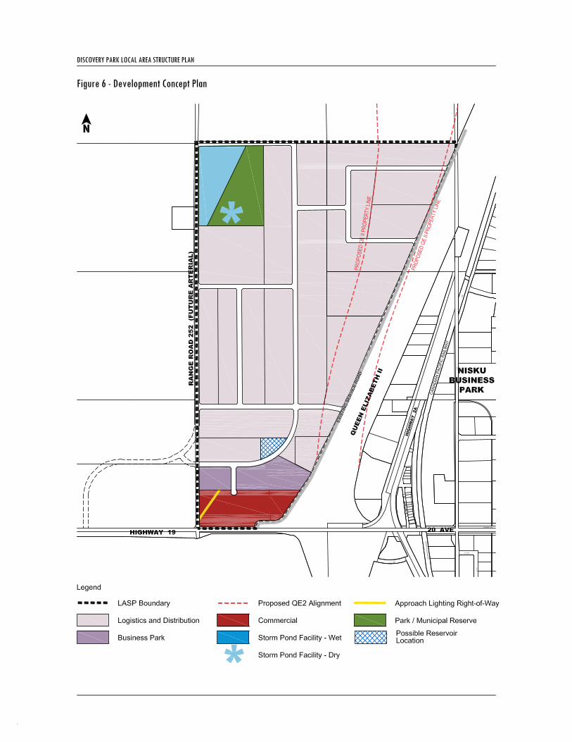
4.3 Land Uses 4.3.1 General The Discovery Park Plan area has been divided into three main usage categories: Commercial, Business Park and Logistics and Distribution. The Commercial area is intended mostly for commercial uses, but may accommodate some complimentary Business Park functions where appropriate. The remainder of the Plan area supports Business Park functions throughout. Within the Logistics and Distribution area, additional Logistics and Distribution functions would also be appropriate. 4.3.2 Commercial Approximately 12.1 hectares of land has been designated Commercial and is indicated on Figure 6 – Development Concept Plan. Located at the intersection of Queen Elizabeth II Highway and Highway 19, the commercial area is highly visible to the travelling public. The intent of the commercial area is to provide highway commercial uses consisting of a mix of retail and vehicle oriented commercial uses.
• To appropriately locate uses within the Plan area. • To provide a range of lot sizes to attract a variety of enterprises. • To provide opportunities for accessory outdoor storage. • To provide Business Park and Logistics and Distribution areas with the opportunity for a
variety of uses that fall within the vision for the Discovery Park Plan area. • To provide Commercial development that will service Leduc County, the greater region, the
travelling public, and complement and support other uses within Discovery Park. • To provide development that will support the Aerotropolis concept. • To provide open space amenities within the Plan area.

Discovery Park Local Area Structure Plan
Page 23 of 51
The commercial uses within Discovery Park will be designed to create the desired “gateway” effect that Leduc County is encouraging along these corridors. The Development Guidelines created for Discovery Park will provide guidance for aesthetic appeal required for development in this area. 4.3.3 Business Park Approximately 10.3 hectares of land has been designated Business Park and is indicated on Figure 6 – Development Concept Plan. The Business Park area may include such things as: corporate offices, research institutions, educational facilities, high-tech enterprise, light indoor manufacturing operations, entertainment facilities/complexes, upper scale hotels, restaurants, retail outlets and large format retail. The Business Park area is highly visible in its proposed location, and as such will be subject to a high level of aesthetic appeal.
Policy 4.3.1: Development adjacent to Highway 19 or the Queen Elizabeth II Highway within the Business Park area shall adhere to a high standard of aesthetic appeal. Refer to the Development Guidelines within this for specific guidance for this area.
4.3.4 Logistics and Distribution Approximately 193.5 hectares of land has been designated Logistics and Distribution and is indicated on Figure 6 – Development Concept Plan. The intent for these lands is to provide greater flexibility for outdoor storage required by Businesses within the Plan area. The Logistics and Distribution area is along the Queen Elizabeth II Highway corridor. Development along the corridor will be of higher aesthetic appeal than the rest of the Logistics and Distribution area where there is visibility from the highway. Development here will be subject to the approval of Alberta Transportation and Leduc County. A high standard of aesthetic appeal is required in order to provide the desired “gateway” effect, which is outlined in the Development Guidelines within this Plan. This area may also accommodate light industrial activities. Some land uses within this area may require outdoor storage and/or display areas which may be accommodated as long as they are in compliance with Leduc County policies. Possible uses within lands designated in the Logistics and Distribution area may include, but are not limited to: warehousing, light manufacturing and accessory outdoor storage. Storage areas will be properly screened from view, and will not detract from the visual appeal of the development. Nuisance factors associated with developments in this area may extend outside of the building envelope, but are not intended to extend beyond the limits of each development site.
Policy 4.3.2: Development adjacent to Highway 19 or the Queen Elizabeth II Highway within the Logistics and Distribution area shall adhere to a high standard of aesthetic appeal. Refer to the Development Guidelines within this for specific guidance for this area.
4.4 Parks The Leduc County Parks & Open Spaces Master Plan locates areas within the County for future parks and open spaces. No lands within the Discovery Park Plan area have been identified for future parks or open space uses by the Master Plan. Section 666(1) of the Municipal Government Act permits municipalities to require up to 10 percent of the developable area (or the cash equivalent) of a proposed subdivision to be dedicated as Municipal Reserve. Specifically, Section 666(1) states that a subdivision authority may require the owner of a parcel of land that is the subject of a proposed subdivision: a) to provide part of that parcel of land as municipal reserve, school reserve or municipal and school reserve, b) to provide money in place of municipal reserve, school reserve, or municipal and school reserve, or

Discovery Park Local Area Structure Plan
Page 24 of 51
c) to provide any combination of land or money referred to in clauses a) and b). The open space park will total approximately 7.5 hectares. This area will be dedicated as Municipal Reserve. In addition to being an amenity for employees in the Discovery Park area, the propose Park will be located within distance of future residential and commercial uses located outside the Plan area. The size of this area will be confirmed at the detailed design stage. The gross developable area of Discovery Park totals approximately 262 hectares, therefore an estimated 26 hectares of land are available to the County for Municipal Reserve dedication. Cash-in-lieu will be required for any additional municipal reserve requirements that the dedication of park space does not satisfy.
Policy 4.4.1: Municipal reserve dedication will be in the form of a combination land and money in place of land for the Plan area and shall total 10 percent of the development area as approved by Leduc County Council.
4.5 Queen Elizabeth II Highway Transitional Policy Area The existing Queen Elizabeth II Highway alignment adjacent to Discovery Park will accommodate the highway needs for the foreseeable future. However, the future interchange design for the major east-west highway / ring road (as identified by Alberta Transportation) is necessitating a realignment of a portion of the Queen Elizabeth II. The future right-of-way of the Queen Elizabeth II will affect approximately 48 hectares of developable land within the Plan area (see Figure 7 – Policy Areas). It is anticipated that lands within the Queen Elizabeth II Highway Transitional Policy Area will initially develop normally in the Logistics and Distribution area and help to serve the needs of County businesses for the next few decades. When required, some phasing out of development will occur, with the then current uses being abandoned and the requisite lands being made available for sale to the relevant authority. This approach is a departure from the current practices of Alberta Transportation; however, it is thought that the interim use of the lands will result in significant benefits accruing to both Leduc County and area land owners. Infrastructure designs will consider this future abandonment with both pre- and post-realignment options. Details relating to lot sizing, lot siting and land use will also be addressed in the latter stages of the development process to ensure that land uses transition appropriately in the future. This Plan recognizes that the future realignment of the Queen Elizabeth II Highway will result in the Highway 2 Corridor Design Guidelines ‘shifting’ to the west to accommodate new lands that will become adjacent to the new Highway right-of-way. As such, all lands located within the transitional overlay as well as lands adjacent to the future alignment as shown on Figure 7 – Policy Areas shall respect the provisions of the Design Guidelines.
Policy 4.5.1: Prior to approval of the first affected subdivision application for land located within the boundaries of the Transitional Policy Area, details relating to lot layout within the parcel of land that is the subject of the proposed subdivision shall be determined to the satisfaction of the approving agency. Policy 4.5.2: Infrastructure designs for lands located within the boundaries of the Transitional Policy Area shall consider the future highway development and include both pre and post realignment options for infrastructure development. Policy 4.5.3: All lands labelled ‘Highway 2 Corridor Design Guideline Area of Applicability’ on Figure 7 – Policy Areas of this Plan shall consider recommendations provided within Section 2.3.3 of the Highway 2 Corridor Design Guidelines for development within this part of the Plan area.

Discovery Park Local Area Structure Plan
Page 25 of 51
Development Statistics Area (ha) GDA (%)
Gross Area 262.36
Environmental Reserve 0.00
Gross Developable Area (GDA) 262.36 100.00
Municipal Reserve 7.5 2.86
Water Reservoir - PUL 1.6 0.61
Stormwater Facility – Wet - PUL 8.3 3.16
Stormwater Facility – Dry - PUL 4.7 1.79
Roadways 21.90 8.35
Sub-Total 44.0 16.77
Net Developable Area 218.36 83.23
Logistics & Distribution 195.96 74.69
Business Park 10.30 3.93
Commercial 12.10 4.61
Sub-Total 218.36 83.23
Total 262.36 100.00 Note: final areas to be confirmed following detailed engineering design Table 3 – Development Statistics


Discovery Park Local Area Structure Plan
Page 28 of 51
5.0 TRANSPORTATION 5.1 General A logical and efficient transportation system is imperative for the long-term functioning of a developed area and the proposed transportation network aims to provide safe and efficient movement of goods and people. The transportation network for Discovery Park will consist of roads, sidewalks and multi-use trails (see Figure 8 – Mobility Plan). 5.2 Transportation Objectives The Discovery Park LASP has the following transportation objectives:
5.3 Access Access will be provided to Discovery Park from roads located along the north and west boundaries of the Plan area. Both of these roadways will be accessible from Highway 19, located along the southern boundary of the Plan area. Additionally, a frontage road located along the eastern boundary of the Plan area will service lands located adjacent to the Queen Elizabeth II Highway. Local roadways will provide access to individual properties located within the Plan area (see Figure 8 – Mobility Plan). 5.4 Traffic Impact Assessment Alberta Transportation requires that a Traffic Impact Assessment (TIA) be prepared for any development located within 800 metres of a provincial highway. The proximity of Discovery Park to the Queen Elizabeth II Highway necessitates the development of a TIA to identify the proposed number of vehicle trips that the development will create and to ensure that existing and proposed road infrastructure will be able to accommodate traffic demands for the TIA study area. A TIA was developed by Focus Corporation to identify and assess potential impacts of the proposed development on the surrounding road network and to develop strategies to mitigate any adverse impacts. The boundaries of the study area considered for the TIA were Highway 19, Township Road 510, Highway 2 and a proposed arterial road located west of Range Road 252. The TIA identified two horizon years as part of the analysis: the full development of Discovery Park in the year 2014 and an ultimate long-term horizon in the year 2028. The TIA assumed a 3 percent growth rate for general traffic activity. The resulting traffic generation under both time horizons is presented below.
• To efficiently move people and goods to and through the Plan area. • To create a roadway hierarchy of collectors and local roadways. • To create a roadway system that works efficiently within the current ring of higher order
arterials to provide access to the regional highway system and major arterials serving Leduc County and the City of Edmonton.
• To provide pedestrian infrastructure consisting of sidewalks and trails. • To allow for connectivity to AirLINKS North on the east side of the Edmonton International
Airport lands to the Discovery Park Plan area.

Discovery Park Local Area Structure Plan
Page 29 of 51
The TIA identified the extent to which Discovery Park can be built out with one signalization (Highway 19/Range Road 252) or with two signalizations (Highway 19/Range Road 252 and Highway 19/proposed arterial). The following table identifies the percent of land designated for Logistics and Distribution development within Discovery Park that can be developed according to a set of assumptions. All scenarios assume full build out of lands designated for Commercial, Business Park, and Logistics and Distribution uses.
*Note: 2028 development assumes land surrounding LASP area has been developed and includes additional signalized intersections on the north-south roadway. 5.5 Roadways A hierarchical roadway network consisting of arterial, collector and local roadways will service the Plan area. Local roadways will be provided within the boundaries of the Plan area. Arterial roads will be developed with vegetated ditches. Within the Commercial and Business Park areas, collector and local roads will be designed with curb and gutter and sidewalks on both sides. Within the Logistics and Distribution area, collector and local roads will be designed with vegetated ditches. The service road is considered temporary in the Plan area. Upon relocation of the Queen Elizabeth II Highway, this service road will be closed.
Traffic Impact Assessment 2014 2028 AM Trips 3,086 4,499 PM Trips 3,752 7,018 Total Trips 6,838 11,517
Build-Out Scenarios
Time Horizon Signalized Intersections
# of Lanes (Highway 19)
Commercial Build-Out?
% of BP/L&D that can be built out
2014 1 4 Yes 45 2014 1 5 Yes 55 2014 1 4 No 70 2014 1 5 No 75 2014 2 6 Yes 95 2014 2 6 No 100 2028* 2 6 Yes 100

Discovery Park Local Area Structure Plan
Page 30 of 51
While subject to final engineering design and approval by Leduc County, the roadway design will generally be in accordance with the following diagrams:
Image 1 – Logistics and Distribution Local Road
Image 2 - Logistics and Distribution Collector Road
Image 3 – Business Park Local Road

Discovery Park Local Area Structure Plan
Page 31 of 51
Image 4 – Business Park Collector Road
Image 5 – Arterial Road
Policy 5.5.1: All roads within the Plan area shall be constructed to the satisfaction of Leduc County.
5.6 Pedestrian and Cycling Linkages Pedestrian and cycling linkages will be provided through various means throughout the Plan area. A multi-use trail will be located on one side of all local, collector and arterial roads throughout the Logistics and Distribution area, see Figure 9 – Pedestrian Circulation. This multi-use trail will provide cyclist and pedestrian connectivity throughout the Plan area and will connect to lands located north and west of the Plan area. Sidewalks on both sides of the street will be provided along all roads throughout the Business Park and Commercial areas. These pedestrian linkages will provide connectivity from the entrances of buildings to the circulation network through the Plan area. Refer to section 7.5- Development Guidelines for a policy regarding this connectivity.
Policy 5.6.1: The Discovery Park Plan area will provide convenient pedestrian and cycling infrastructure throughout the Plan area to encourage a modal shift away from the personal automobile.
5.7 Park and Ride Discovery Park supports Park and Ride uses within the Plan area when they are required to support public transit. Park and Ride could also be accommodated within the Plan area to support airport uses. Developers within the Discovery Park Plan area will work with Leduc County to identify appropriate locations for Park and Ride facilities.


Discovery Park Local Area Structure Plan
Page 34 of 51
6.0 SERVICING 6.1 General Servicing of the Discovery Park LASP area will consist of water, storm and sanitary infrastructure as well as utilities such as power, natural gas, phone and cable. Extensions or connections to regional water and wastewater trunks for servicing are planned. With the first stage of development, a connection to the Water Commission supply line and a connection to the Southeast Regional Trunk will be required. This section depicts the general servicing concepts for Discovery Park. The details of these concepts will be further defined through subsequent reports and detailed engineering design in the future. 6.2 Servicing Objectives The Discovery Park LASP has the following servicing objectives:
6.3 Water Servicing The Capital Region South-West Water Commission will service the Plan area from a water transmission pipe located along the existing right-of-way of the Queen Elizabeth II Highway to a proposed reservoir pumphouse to be located in the southeast corner of the Plan area. Water will be supplied from the reservoir to a fill station connected to the reservoir pumphouse. The reservoir will be sized to provide fire storage equal to providing 227 litres per second for a duration of 4 hours, equalization storage of 25 percent peak day and two day average storage. Water will be distributed through the Plan area via water mains (see Figure 10 – Water Servicing Plan). It is intended that pumping equipment be sized appropriately to service the development area and be upgraded as required to keep pace with any increases in demand. Treated water storage is to be constructed in increments, with total storage of 65,000 c.m. at the reservoir site proposed within close proximity to the Plan area. Water servicing for Discovery Park is dependant on some pertinent factors, as follows:
• Initial discussions with the Water Commission have confirmed that there is capacity to supply the area; however, the Commission will need to confirm the flow rate and any associated restrictions.
• Presently only two connections are permitted to the Water Commission supply line and a third connection for the Plan area is required. Leduc County will be requested to assist with an application for a third connection;
• Funding for the reservoir and pumphouse, supply line and oversizing trunk mains is an issue that will need to be addressed by both Leduc County and the Water Commission as the source of funding for construction has yet to be determined.
Policy 6.3.1: Prior to proceeding with the design of the connection to the Water Commission supply line, guidelines to establish the volume that can be diverted and allowable flow from the supply line shall be confirmed with the Water Commission.
• To provide effective utility servicing for the Plan area by staging the construction of utilities to correspond with the demand.
• To meet Leduc County and Edmonton International Airport stormwater management guidelines while encouraging acceptable Low-Impact Development strategies.

Discovery Park Local Area Structure Plan
Page 35 of 51
6.4 Sanitary Sewer Sanitary servicing will require constructing gravity sanitary sewers sloping from south to north and discharging to an interim lift station located along the north boundary of the Plan area (see Figure 11 – Sanitary Servicing Plan). Wastewater pumped from the lift station will be conveyed to the South East Regional Trunk (SERT) outfall located on the east side of the Queen Elizabeth II Highway and through an interim forcemain proposed to service Discovery Park. Wastewater servicing for discovery Park is dependent on the available capacity of the SERT outfall to accept the wastewater flows as well as approval by the Alberta Capital Regional Wastewater Commission. Initial discussions with the Alberta Capital Regional Wastewater Commission have confirmed there is available capacity. The Wastewater Commission and Leduc County should prepare guidelines for connection to the outfall.
Policy 6.4.1: Prior to finalizing the wastewater concept, the location of the connection, the required wastewater storage and the alignment of the sewage forcemain shall be confirmed.
6.5 Stormwater Management In November 2008, Leduc County released a draft Conceptual Stormwater Servicing Strategy for the greater planning area. According to this report, the maximum allowable release rate for the study area has been set to 4.25 L/s/ha (0.4265 m3/s/km2). The Edmonton International Airport Diverge Area (see Figure 5 – Edmonton International Airport Stormwater Management Zones) establishes restrictions on the provision of stormwater management ponds within the Plan area based on the following 3 zones (see Figure 5): 1. Zone 1 – Wet ponds are permitted. They should be located in safe areas and modified (designed with steep
banks) so as not to attract hazardous birds. 2. Zone 2 – Wet ponds are prohibited. Dry ponds are permitted. Fencing and overhead wire systems might be
required to prevent waterfowl from approaching the stormwater management facilities. 3. Zone 3 – Exposed stormwater management facilities are prohibited. Based upon the above guidelines, one stormwater management facility (SWMF) allowing standing water shall be required in the northwest corner of the Plan area, as outlined on Figure 12 – Stormwater Servicing Plan. The stormwater management facility will consist of an 8 hectare wet pond and will be entirely located within Zone 1 of the Diverge Area. An additional 5 hectare dry pond will be located adjacent to the wet pond in the same area. The sizes and details of the SWMF design are approximate and subject to detailed engineering design.
Discharge from the wet pond will flow west and north along the proposed road alignments and west again, along Township Road 510 to Whitemud Creek. In the long-term it is envisioned that, as development proceeds west of the Plan area, a network of stormwater management facilities will be constructed. Discharge from Discovery Park will be integrated into an overall Stormwater Management Plan as identified as part of the draft Conceptual Stormwater Servicing Strategy. Runoff that cannot be directed west to the future stormwater pond from the northeast will require underground storage on individual properties. From there, it will be treated and released at the pre-development rate to an existing receiving roadway ditch.

Discovery Park Local Area Structure Plan
Page 36 of 51
At the detailed design stage, the composition of the stormwater management facility will be fully defined. It may be possible for a portion of the stormwater pond to be developed as a naturalized wetland facility. 6.6 Low-Impact Development Discovery Park will encourage the design and integration of Low-Impact Development (LID) principles. LID is an approach to stormwater management that strives to mimic natural processes in an effort to distribute infiltration rather than providing artificial, point-source treatment.
Policy 6.6.1: Prior to issuance of a Development Permit, a Landscaping Plan shall be developed to the satisfaction of the approving agency. The Plan shall incorporate regionally-appropriate, water-resistant plantings and shall demonstrate inclusion of Low Impact Development techniques, including which may include, but is not limited to: tree box filters, rain gardens and green roofs. Section 7.5 outlines the related landscaping development guidelines that must be followed.
The following table outlines various ways that on-site LID stormwater management practices can be integrated into the development: • Rain gardens – vegetated areas intended to
capture run-off from impervious surfaces.
• Bioswales – sloped drainage courses intended to capture run-off from impervious surfaces. The pre-treated stormwater is then directed to a watershed or storm sewer.
• Infiltration trenches – rock-filled trenches through which pre-treated stormwater infiltrates into the soil structure.
• Green roofs – vegetated areas of a roof which may or may not include root systems.

Discovery Park Local Area Structure Plan
Page 37 of 51
• Permeable pavers – permeable surfaces used in place of non-porous surfaces for sidewalks, parking areas and driveways.
• Dry wells – aggregate filled pits used to infiltrate runoff that has been redirected from rooftops.
• Rain barrels – containers for the collection and storage of rainwater from roofs. Often used for on-site irrigation.
• Tree box filters – in-ground containers for the collection and pre-treatment of stormwater.
Policy 6.6.2: Prior to finalizing the stormwater management concept, an optimum stormwater strategy shall be determined with effort to minimize site grading. Policy 6.6.3: Prior to finalizing the stormwater management concept, Low-Impact Development measures shall be considered. Policy 6.6.4: Stormwater management wet ponds shall be permitted within Zone 1 of the Diverge Area; dry ponds shall be permitted within Zone 1 and 2 of the Diverge Area and no stormwater management faculties shall be permitted within Zone 3 of the Diverge Area.
6.7 Shallow Utilities Shallow utilities such as natural gas, power, street lighting, phone and cable are available in both the Nisku and Edmonton International Airport areas. Utilities will be extended by the respective franchise utility companies from their major trunk services. Utilities will be placed within road rights-of-way or within easements registered to lands within the Plan area. As fibre optic technology is brought to the Discovery Park area by the appropriate service providers, it will be incorporated as part of the shallow utilities plan. 6.8 Emergency Response Services Development within Discovery Park will be designed to accommodate emergency services.

Discovery Park Local Area Structure Plan
Page 38 of 51
Ambulatory services for Discovery Park will be covered by Parkland Ambulance Authority. Policing within Discovery Park will be managed by the RCMP from the base within the City of Leduc. Fire protection services within Discovery Park will be covered by Leduc County Fire Services from the Nisku Fire Hall, located at 606 21st Avenue, Nisku. Leduc County has an intermunicipal agreement for Fire Protection Services with surrounding municipalities and the Edmonton International Airport.


Discovery Park Local Area Structure Plan
Page 42 of 51
7.0 IMPLEMENTATION 7.1 General The Discovery Park LASP provides a policy framework for development. Once adopted, policies contained within the Plan will direct the manner in which development occurs within the Plan area. There are a number of studies, approvals and infrastructural improvements that will directly influence the ability of Discovery Park to function as envisioned within this Plan, such as:
• Upgrades to Highway 19; • Servicing funding and approvals; and • Favourable market conditions.
This Plan recognizes that development is subject to market conditions and has sought to provide flexibility to facilitate development under a range of conditions. This Plan should also be adaptable to accommodate for changes in areas such as sustainable technology, stormwater management techniques, etc. The Plan should be interpreted in a manner that considers the importance of these activities and allows for modification of the Plan through approval processes as required. 7.2 Zoning Land within the Discovery Park LASP boundaries is currently zoned AG (Agricultural) by Leduc County Land Use Bylaw No. 7-08. The purpose of the AG (Agricultural) district is to “provide primarily for larger agricultural operations and limited higher intensity agricultural activities on smaller lots, while at the same time providing for limited residential and other uses having a secondary role to agriculture” (page 9-1). Lands designated for Commercial, Business Park, Logistics and Distribution, Park and Public Utility uses within this Plan will require rezoning to an appropriate land use district within Leduc County Land Use Bylaw. 7.3 Development Staging Development is expected to commence in the southern portion of the Plan area adjacent to Highway 19 to take advantage of the access, with offsite water and sewer facilities constructed with the initial stage (see Figure 13 – Development Staging). Stormwater management will be constructed as necessary as part of the first stage. Notwithstanding the staging plan, a significant amount of the infrastructure for the entire development will need to be constructed as part of stage 1. 7.4 Cost Sharing Off-site levies are anticipated to assist with the cost sharing of off-site infrastructure. As development proceeds, negotiations with the County and developers will determine the levels of contribution. 7.5 Amendments to the Plan Amendments to the Discovery Park Local Area Structure Plan may be initiated by person(s) with interest in the plan area. In this event, the proponent must follow all Leduc County procedures for statutory plan amendment.

Discovery Park Local Area Structure Plan
Page 43 of 51
7.6 Development Guidelines Objective 1: Irrespective of use, all developments shall enhance the character of their surrounding area through quality architecture, enhanced landscaping, and appropriate and considered site configuration. A “thread of continuity” must exist throughout the Plan area.
Policy 7.6.1: All street facing front and side yards must maintain a continuous landscape strip of at least 6.0 m when measured from inside the property line. This landscape strip may only be interrupted by driveway crossings and must provide a minimum of four deciduous trees (a minimum calibre of 7.6cm), four coniferous trees (a minimum height of 3m) and 20 shrubs for each 30m of linear yard frontage. Policy 7.6.2: Perimeter landscaping in every development shall transition or integrate with the landscaping of adjacent sites to create streetscape continuity. Policy 7.6.3: Principal facades of buildings visible from a public street shall include architectural elements such as plane articulation, changes in material, texture, and colour, and a more generous percentage of windows and openings to minimize the perceived mass of the building and to create visual interest. Policy 7.6.4: Enhanced landscape planting is encouraged adjacent to exterior walls that are visible from adjacent public road or parks to minimize the perceived mass of the building and to create visual interest. Policy 7.6.5: Principal entrances and primary building elevations should orient to public streets and should be well-defined. Policy 7.6.6: All buildings shall be faced with materials which exhibit a durable permanent quality appearance and are considered for their noise mitigation properties where appropriate. Materials should not stain easily, either due to atmospheric conditions or when used in combination with other materials. Materials should be of a low maintenance type retaining a consistent clean appearance. Policy 7.6.7: Give additional consideration to articulated facades and landscaping located along Highway 19 and Highway 2 to aid in the creation of the desired gateway effect. Policy 7.6.8: All developments are encouraged to make private provision for specifically designed outdoor amenity spaces connected by a walkway system to the on-site principal building(s). Policy 7.6.9: Every building on a parcel with a public entrance shall have at least one sidewalk connecting the entrance to a public sidewalk or street. Policy 7.6.10: Outside display areas shall be permitted provided they are not located in required front, side, or rear yard setbacks and are limited to merchandise related to the uses on-site. Policy 7.6.11: A Signage Plan shall be submitted to Leduc County at time of development permit application in accordance with the Land Use Bylaw. Temporary signage is prohibited with the exception of temporary signs required during development and or building construction. Policy 7.6.12: No advertising matter of any kind, not associated with the direct business approved by the County of Leduc, except the ordinary signs offering a Building Lot or Development thereon for sale or rent, or an ordinary sign, identifying the owner-occupant or the address of the Building Lot on an

Discovery Park Local Area Structure Plan
Page 44 of 51
entrance sign to the Building Lot, or a sign erected by a builder during construction of a building on a Building Lot, shall be placed on any Building Lot. Policy 7.6.13: For multi-phase and/or multi-building developments, an apparent visual relationship between buildings or phases shall be evident by employing massing relationships, architectural or landscape design elements like courtyards, walkways, or landscaping to conceptually connect the overall development. Policy 7.6.14: All development within Discovery Park shall consider Crime Prevention through Environmental Design (CPTED) principles.
Objective 2: The various site components – buildings, parking areas and driveways, landscaping, and outdoor storage functions – shall be configured to emphasize the aesthetically positive aspects while minimizing the less aesthetically pleasing aspects of the development.
Policy 7.6.15: Orient buildings so that building entrances, offices areas and pedestrian-scaled amenities are situated on the publicly visible sides of the site. Policy 7.6.16: All service areas – vehicular activity yards, garbage enclosures, outside storage, loading areas, at-grade or rooftop mechanical equipment – shall be located so as to be visually screened from public thoroughfares, and, where the screening is man-made, shall be integrated with the pervading building character – preferably constructed of the same materials employed on the principal building(s). Policy 7.6.17: Outdoor storage shall be permitted within the Logistics and Distribution area provided any negative visual impacts associated with the storage are sufficiently mitigated through the use of building placement, landscaping, berming and other suitable forms of screening. Policy 7.6.18: Chain linked and barbed wire fences for outdoor storage security are permitted in the Logistics and Distribution Area; however, some form of fence improvement or landscape buffer shall be provided to screen the outside storage area and fence from adjacent streets. Policy 7.6.19: Yard and storage areas may be surfaced with recycled asphalt, recycled concrete, or other compacted, non-dust emitting materials; however, these areas must be internal to the site, visually screened and not have direct access to public streets.
Objective 3: To address climate change and encourage green building principles. Policy 7.6.20: All development within the Discovery Park Plan area shall be promoted and encouraged to utilize a sustainable building standard such as LEED, Built Green, etc. Policy 7.6.21: All planting within the Plan area shall be regionally appropriate and water-resistant. Policy 7.6.22: Xeriscaping techniques may be used to reduce watering requirements. Policy 7.6.23: Where possible, developments are encouraged to incorporate building materials that are recycled and/or locally sourced. Policy 7.6.24: All outdoor lighting must be designed utilizing dark skies principles. In addition, outdoor lighting shall be located, oriented and shielded to prevent light from being directed at adjoining properties, interfering with the use and enjoyment of neighbouring lands or disrupting the effectiveness of any air traffic control devices or other Edmonton International Airport equipment.

Discovery Park Local Area Structure Plan
Page 45 of 51
Policy 7.6.25: Where possible, and subject to approval by the Development Authority, businesses are encouraged to develop shared parking strategies to take advantage of shared parking lots between sites. Policy 7.6.26: Developments will be encouraged to carefully consider their use of paving materials to reduce the impact of site development on the environment. Policy 7.6.27: The re-use of grey water and rainwater is encouraged for industrial and landscaping purposes to achieve water savings and reduce the amount of water waste generated on site. Policy 7.6.28: Provide preferential parking spaces for carpoolers, small vehicles, and/or vehicles with low emissions and high gas mileage (i.e., hybrids) along with the provisions of bicycle storage for staff and visitors.


Discovery Park Local Area Structure Plan
Page 47 of 51
8.0 POLICY SUMMARY The policies included within this LASP should be considered as part of future stages of the development process. In an effort to simplify the implementation of these works, a summary is provided below:
Policy 2.8.1: Compensation for any existing wetlands removed from the plan area will be in accordance with Alberta’s Wetland Policy. ...................................................................................................................................................................... 11
Policy 2.8.2: Details of the Wetland Compensation Plan within Discovery Park will be determined in subsequent stages of development........................................................................................................................................................................... 11
Policy 2.9.1: Prior to subdivision approval, a Historical Resources Inventory and Assessment (HRIA) will be required with respect to SE1/4-35-50-25-W4M to the satisfaction of the approving agency. The HRIA will be prepared by a qualified professional and will be developed. .................................................................................................... 11
Policy 3.6.1: All land within the Discovery Park Plan area will remain zoned AG – Agricultural until rezoned for development. ............................................................................................................................................................................................. 17
Policy 3.10.1: All development within the Discovery Park Plan area shall comply with the Edmonton International Airport Vicinity Protection Regulation (Alta. Reg. 55/2006)................................................................... 18
Policy 3.11.1: Development within the Discovery Park Plan area shall follow the recommendations for land use set out in TP 1247, Land Use in the Vicinity of Airports. ...................................................................................................... 19
Policy 3.12.1: No stormwater management facilities that allow standing water shall be developed in zones 2 and 3 within the Discovery Park Plan area.............................................................................................................................................. 19
Policy 3.13.1: Developers within the Discovery Park Plan area shall work cooperatively with Edmonton International Airport and NAV Canada to ensure that any development that impacts the Approach Lighting Right-of Way is done appropriately. .............................................................................................................................................................. 19
Policy 4.3.1: Development adjacent to Highway 19 or the Queen Elizabeth II Highway within the Business Park area shall adhere to a high standard of aesthetic appeal. Refer to the Development Guidelines within this for specific guidance for this area............................................................................................................................................................. 23
Policy 4.3.2: Development adjacent to Highway 19 or the Queen Elizabeth II Highway within the Logistics and Distribution area shall adhere to a high standard of aesthetic appeal. Refer to the Development Guidelines within this for specific guidance for this area.................................................................................................................................. 23
Policy 4.4.1: Municipal reserve dedication will be in the form of a combination land and money in place of land for the Plan area and shall total 10 percent of the development area as approved by Leduc County Council. ...... 24
Policy 4.5.1: Prior to approval of the first affected subdivision application for land located within the boundaries of the Transitional Policy Area, details relating to lot layout shall be determined for all lands therein to the satisfaction of the approving agency................................................................................................................................................. 24
Policy 4.5.2: Infrastructure designs for lands located within the boundaries of the Transitional Policy Area shall consider the future highway development and include both pre and post realignment options for infrastructure development. ............................................................................................................................................................................................. 24

Discovery Park Local Area Structure Plan
Page 48 of 51
Policy 4.5.3: All lands labelled ‘Highway 2 Corridor Design Guideline Area of Applicability’ on Figure 7 – Policy Areas of this Plan shall consider recommendations provided within Section 2.3.3 of the Highway 2 Corridor Design Guidelines for development within this part of the Plan area. ................................................................................... 24
Policy 5.5.1: All roads within the Plan area shall be constructed to the satisfaction of Leduc County. ...................... 31
Policy 5.6.1: The Discovery Park Plan area will provide convenient pedestrian and cycling infrastructure throughout the Plan area to encourage a modal shift away from the personal automobile. .......................................... 31
Policy 6.3.1: Prior to proceeding with the design of the connection to the Water Commission supply line, guidelines to establish the volume that can be diverted and allowable flow from the supply line shall be confirmed with the Water Commission. ................................................................................................................................................................ 34
Policy 6.4.1: Prior to finalizing the wastewater concept, the location of the connection, the required wastewater storage and the alignment of the sewage forcemain shall be confirmed.............................................................................. 35
Policy 6.6.1: Prior to issuance of a Development Permit, a Landscaping Plan shall be developed to the satisfaction of the approving agency. The Plan shall incorporate regionally-appropriate, water-resistant plantings and shall demonstrate inclusion of Low Impact Development techniques, including which may include, but is not limited to: tree box filters, rain gardens and green roofs. Section 7.5 outlines the related landscaping development guidelines that must be followed.............................................................................................................................. 36
Policy 6.6.2: Prior to finalizing the stormwater management concept, an optimum stormwater strategy shall be determined with effort to minimize site grading. ............................................................................................................................ 37
Policy 6.6.3: Prior to finalizing the stormwater management concept, Low-Impact Development measures shall be considered. .......................................................................................................................................................................................... 37
Policy 6.6.4: Stormwater management wet ponds shall be permitted within Zone 1 of the Diverge Area; dry ponds shall be permitted within Zone 1 and 2 of the Diverge Area and no stormwater management faculties shall be permitted within Zone 3 of the Diverge Area............................................................................................................................ 37
Policy 7.6.1: All street facing front and side yards must maintain a continuous landscape strip of at least 6.0 m when measured from inside the property line. This landscape strip may only be interrupted by driveway crossings and must provide a minimum of four deciduous trees (a minimum calibre of 7.6cm), four coniferous trees (a minimum height of 3m) and 20 shrubs for each 30m of linear yard frontage. .................................................... 43
Policy 7.6.2: Perimeter landscaping in every development shall transition or integrate with the landscaping of adjacent sites to create streetscape continuity.............................................................................................................................. 43
Policy 7.6.3: Principal facades of buildings visible from a public street shall include architectural elements such as plane articulation, changes in material, texture, and colour, and a more generous percentage of windows and openings to minimize the perceived mass of the building and to create visual interest. ................................................. 43
Policy 7.6.4: Enhanced landscape planting is encouraged adjacent to exterior walls that are visible from adjacent public road or parks to minimize the perceived mass of the building and to create visual interest. ............................ 43
Policy 7.6.5: Principal entrances and primary building elevations should orient to public streets and should be well-defined................................................................................................................................................................................................ 43

Discovery Park Local Area Structure Plan
Page 49 of 51
Policy 7.6.6: All buildings shall be faced with materials which exhibit a durable permanent quality appearance and are considered for their noise mitigation properties where appropriate. Materials should not stain easily, either due to atmospheric conditions or when used in combination with other materials. Materials should be of a low maintenance type retaining a consistent clean appearance. ............................................................................................ 43
Policy 7.6.7: Give additional consideration to articulated facades and landscaping located along Highway 19 and Highway 2 to aid in the creation of the desired gateway effect................................................................................................ 43
Policy 7.6.8: All developments are encouraged to make private provision for specifically designed outdoor amenity spaces connected by a walkway system to the on-site principal building(s). ..................................................... 43
Policy 7.6.9: Every building on a parcel with a public entrance shall have at least one sidewalk connecting the entrance to a public sidewalk or street. ............................................................................................................................................ 43
Policy 7.6.10: Outside display areas shall be permitted provided they are not located in required front, side, or rear yard setbacks and are limited to merchandise related to the uses on-site. ................................................................ 43
Policy 7.6.11: A Signage Plan shall be submitted to Leduc County at time of development permit application in accordance with the Land Use Bylaw. Temporary signage is prohibited with the exception of temporary signs required during development and or building construction........................................................................................................ 43
Policy 7.6.12: No advertising matter of any kind, not associated with the direct business approved by the County of Leduc, except the ordinary signs offering a Building Lot or Development thereon for sale or rent, or an ordinary sign, identifying the owner-occupant or the address of the Building Lot on an entrance sign to the Building Lot, or a sign erected by a builder during construction of a building on a Building Lot, shall be placed on any Building Lot........................................................................................................................................................................................ 43
Policy 7.6.13: For multi-phase and/or multi-building developments, an apparent visual relationship between buildings or phases shall be evident by employing massing relationships, architectural or landscape design elements like courtyards, walkways, or landscaping to conceptually connect the overall development. .................. 44
Policy 7.6.14: All development within Discovery Park shall consider Crime Prevention through Environmental Design (CPTED) principles. ................................................................................................................................................................. 44
Policy 7.6.15: Orient buildings so that building entrances, offices areas and pedestrian-scaled amenities are situated on the publicly visible sides of the site............................................................................................................................. 44
Policy 7.6.16: All service areas – vehicular activity yards, garbage enclosures, outside storage, loading areas, at-grade or rooftop mechanical equipment – shall be located so as to be visually screened from public thoroughfares, and, where the screening is man-made, shall be integrated with the pervading building character – preferably constructed of the same materials employed on the principal building(s). .................................................. 44
Policy 7.6.17: Outdoor storage shall be permitted within the Logistics and Distribution area provided any negative visual impacts associated with the storage are sufficiently mitigated through the use of building placement, landscaping, berming and other suitable forms of screening. ........................................................................... 44
Policy 7.6.18: Chain linked and barbed wire fences for outdoor storage security are permitted in the Logistics and Distribution Area; however, some form of fence improvement or landscape buffer shall be provided to screen the outside storage area and fence from adjacent streets. ......................................................................................... 44

Discovery Park Local Area Structure Plan
Page 50 of 51
Policy 7.6.19: Yard and storage areas may be surfaced with recycled asphalt, recycled concrete, or other compacted, non-dust emitting materials; however, these areas must be internal to the site, visually screened and not have direct access to public streets. .......................................................................................................................................... 44
Policy 7.6.20: All development within the Discovery Park Plan area shall be promoted and encouraged to utilize a sustainable building standard such as LEED, Built Green, etc. ........................................................................................... 44
Policy 7.6.21: All planting within the Plan area shall be regionally appropriate and water-resistant........................... 44
Policy 7.6.22: Xeriscaping techniques may be used to reduce watering requirements................................................... 44
Policy 7.6.23: Where possible, developments are encouraged to incorporate building materials that are recycled and/or locally sourced. ........................................................................................................................................................................... 44
Policy 7.6.24: All outdoor lighting must be designed utilizing dark skies principles. In addition, outdoor lighting shall be located, oriented and shielded to prevent light from being directed at adjoining properties, interfering with the use and enjoyment of neighbouring lands or disrupting the effectiveness of any air traffic control devices or other Edmonton International Airport equipment. .................................................................................................................... 44
Policy 7.6.25: Where possible, and subject to approval by the Development Authority, businesses are encouraged to develop shared parking strategies to take advantage of shared parking lots between sites. .......... 45
Policy 7.6.26: Developments will be encouraged to carefully consider their use of paving materials to reduce the impact of site development on the environment. .......................................................................................................................... 45
Policy 7.6.27: The re-use of grey water and rainwater is encouraged for industrial and landscaping purposes to achieve water savings and reduce the amount of water waste generated on site. ........................................................... 45
Policy 7.6.28: Provide preferential parking spaces for carpoolers, small vehicles, and/or vehicles with low emissions and high gas mileage (i.e., hybrids) along with the provisions of bicycle storage for staff and visitors. 45

Discovery Park Local Area Structure Plan
Page 51 of 51
9.0 REFERENCES Bison Historical Resources Ltd. (2008) Historical Resources Overview. Leduc County. Edmonton Airports. (June 2007). Edmonton International Airport Area Structure Plan and Implementation Plan.
Prepared by Urban Systems. Government of Alberta. (2009). Capital Region Board Growth Plan. Government of Alberta. (2000). Edmonton International Airport Vicinity Protection Area Regulation. Government of Alberta. (2004). Municipal Government Act. Government of Alberta. (April 2008). Alberta Oil Sands Projects. Accessed 27 November 2008 from:
http://www.energy.alberta.ca/LandAccess/pdfs/OilSands_Projects.pdf. Government of Alberta. (September 2008). Alberta’s Oil Sands. Resourceful. Responsible. ISL Engineering and Land Services. (November 2007). Capital Region Integrated Growth Management Plan
Final Report on Land Use. Prepared for Alberta Infrastructure and Transportation. J.R. Paine & Associates Ltd. (March 2008). Geotechnical Investigation, Proposed Industrial Subdivision, Nisku
West Industrial Subdivision, NW/SW26-50-25-W4M & SW35-50-25-W4M, Leduc County, Alberta. Leduc County. Leduc County Design Guidelines and Construction Standards for Development. Leduc County. Leduc County. (2001) Leduc County Transportation Master Plan. Leduc County. Leduc County. (2004) Municipal Development Plan. Leduc County. Leduc County. (2006) Edmonton International Airport Vicinity Protection Area Regulation. Leduc County Leduc County. (2010) Highway 19 Area Structure Plan. Leduc County Parkland Community Planning Services. (2004) Leduc County North Major Area Structure Plan. Leduc County. Spencer Environmental Management Services Ltd. (November 2008). Discovery Business Park Area Structure
Plan Biophysical Assessment. Timilsina, Govinda R., Nicole LeBlanc and Thorn Walden. (2005). “Economic Impacts of Alberta’s Oil Sands”.
Canadian Energy Research Institute.