Embed Size (px)
Citation preview
A DESKTOP ETHNOGRAPHIC ABORIGINAL HERITAGE SURVEY OF THE HIGH STREET UPGRADE BETWEEN STIRLING HIGHWAY AND CARRINGTON STREET, FREMANTLE,
WESTERN AUSTRALIA. A report prepared for ARRB Group Ltd.
By Mr Brad Goode Consulting Anthropologist 79 Naturaliste Terrace DUNSBOROUGH WA 6281 [email protected]
Mr Colin (Floyd) Irvine
Consulting Historian PO Box 601 Dunsborough WA 6281 [email protected]
Report submitted March 2008 to: Mr Paul Fourie Team Leader – Transport Planning WA ARRB Group Ltd 191 Carr Place LEEDERVILLE WA 6007 The Registrar Department of Indigenous Affairs PO Box 7770 Cloisters Square PERTH WA 6000

A DESKTOP ETHNOGRAPHIC ABORIGINAL HERITAGE SURVEY OF THE HIGH STREET UPGRADE BETWEEN STIRLING HIGHWAY AND CARRINGTON STREET, FREMANTLE, WESTERN AUSTRALIA.
_______________________________________________________________________________________________________
1
EXECUTIVE SUMMARY The Department for Planning and Infrastructure (DPI) wish to identify all previously recorded Aboriginal Heritage sites located within an area between the west of Stirling Highway to the east of Carrington Street along High Street in Fremantle. This study is requested in order to identify any areas of Aboriginal significance that may have been previously recorded within the area of proposed modifications to High Street in order for the proponents to be able to fulfil their obligations with regards to the West Australian Aboriginal Heritage Act (1972). Archival research has revealed that there is a rich record of pre-European and post contact Nyungar occupation of the Fremantle area. The area now subject to this study does not contain any previously recorded Aboriginal Heritage sites but has not been previously surveyed. Several adjacent studies (Burke 2006, McDonald 1997, 2003, 2004 and O’Connor and Thompson 1984) to the survey area do exist and point to a rich record of heritage sites recorded in the region. Few pre-historic artefact sites have been recorded in Fremantle which is largely a result of the fact that the area has undergone high degrees of disturbance from urbanization which has destroyed or concealed the archaeological signature. Some potential for artefacts to be unearthed during excavation and earthworks remains in areas around the coastal margin, lakes and the Swan River. (Burke 2006). Ethno-historical research indicates that Fremantle was formerly known as Walyalup and that it was a major meeting and dwelling place for traditional Nyungar people and was known as a place for undertaking trade and ceremonies. Fremantle was a place the Swan River could be crossed and so was an important link on a Bidi (track) that ran from Perth to the south of the river and beyond (De Gande, 2000; see also Bates in McDonald 2003). Several landscape features in the Fremantle area are identified as having mythological significance. The Limestone Ridge near Coogee that runs parallel with the coastline was reported to be mythologically created as was Lake Coogee (McDonald 2003). Mention is also made of an initiate’s camp near the ‘burying ground’ in Fremantle by Bates (McDonald 2003). With regards to these mythological sites a cautionary note is sounded by McDonald regarding boundaries that are unclear and that may be extended beyond what has been previously mapped (McDonald; 2003). During the historical period Aboriginal people lived in fringe camps around the Fremantle area and appear to have been concentrated to the south around Robs Jetty (the Smelters). The area around the Fremantle Cemetery is also identified as a location Aboriginal people camped in during the historical period (McDonald 1997, 2003). This may have some relevance to our current project as it appears Nyungars were targeting undeveloped land to establish fringe camps late in history. The area where the golf course is bordering High Street may be such a place depending upon its land use prior to it becoming a golf course. Only consultations with Nyungar people could establish this. As the project is to affect land that is now a road and an urban area it is not likely that areas of heritage significance will be affected. As adjacent land to High Street has undergone surveys in the past and no major ethnographic sites have been recorded it is not likely that the area under consideration would now contain any places of current heritage significance. However at a desktop level this is impossible to determine with any certainty. Only consultation with knowledgeable Nyungars such as Mr Patrick Hume who is now 85 years of age and has spent his life in the area can establish with certainty that no sites now exist in the area where the High Street upgrade will take place. As a result of this desktop report it is recommended that the upgrade to High Street can proceed as planned as no previously recorded Aboriginal Heritage sites have been identified to be in conflict with the project plans.
A DESKTOP ETHNOGRAPHIC ABORIGINAL HERITAGE SURVEY OF THE HIGH STREET UPGRADE BETWEEN STIRLING HIGHWAY AND CARRINGTON STREET, FREMANTLE, WESTERN AUSTRALIA.
_______________________________________________________________________________________________________
2
It is further recommended that should the project plans identify a need to affect areas to the east or west of the area currently identified for works that a full Aboriginal Heritage survey which would include archaeological inspections and consultations with the appropriate Aboriginal groups be conducted. Areas of particular focus for such a survey would be in the vicinity of the Fremantle Cemetery, an area known as a historic camp ground. It is also recommended that if the current plans require significant works that affect the golf course that the proponents conduct consultations with local Aboriginal representatives that would be able to determine if these camps extended west from the Cemetery into this area.
A DESKTOP ETHNOGRAPHIC ABORIGINAL HERITAGE SURVEY OF THE HIGH STREET UPGRADE BETWEEN STIRLING HIGHWAY AND CARRINGTON STREET, FREMANTLE, WESTERN AUSTRALIA.
_______________________________________________________________________________________________________
3
CONTENTS EXECUTIVE SUMMARY......................................................................................................... 1
ISSUE ........................................................................................................................................... 4
REPORT OBJECTIVES............................................................................................................ 4
BACKGROUND ......................................................................................................................... 4
LOCATION................................................................................................................................. 6
ETHNOGRAPHIC & HISTORICAL BACKGROUND ........................................................ 7 TRADITIONAL NYUNGAR CULTURE ........................................................................................... 7
ARCHIVAL RESEARCH........................................................................................................ 10 SITES REGISTER SEARCH.......................................................................................................... 10 REVIEW OF RELEVANT SITE FILES.......................................................................................... 10 REGISTERED DIA SITES WITHIN THE CITY OF FREMANTLE.................................................... 11 REVIEW OF RELEVANT ETHNOGRAPHIC REPORTS ................................................................... 12 RESULTS OF ARCHIVAL RESEARCH ......................................................................................... 15
NATIVE TITLE CLAIMS OVERLAPPING THE FREMANTLE AREA ........................ 16
RECOMMENDATIONS.......................................................................................................... 18
BIBLIOGRAPHY ..................................................................................................................... 19
APPENDIX 1. SITES REGISTER SEARCH......................................................................... 21
APPENDIX 2. MAP OF THE PROJECT AREA .................................................................. 22
APPENDIX 3. OBLIATIONS RELATING TO SITES UNDER THE ABORIGINAL HERITAGE ACT (1972) .......................................................................................................... 23
LIST OF TABLES TABLE 1 SUMMARY OF REGISTERED ABORIGINAL HERITAGE SITES LOCATED WITHIN THE
REGISTER SEARCH AREA..................................................................................................... 10 TABLE 2 SUMMARY OF REGISTERED ABORIGINAL HERITAGE SITES LOCATED WITHIN THE
FREMANTLE SHIRE AREA. ................................................................................................... 12
LIST OF FIGURES FIGURE 1. LOCATION OF THE PROJECT AREA ............................................................................... 6
A DESKTOP ETHNOGRAPHIC ABORIGINAL HERITAGE SURVEY OF THE HIGH STREET UPGRADE BETWEEN STIRLING HIGHWAY AND CARRINGTON STREET, FREMANTLE, WESTERN AUSTRALIA.
_______________________________________________________________________________________________________
4
REPORT
A Desktop Ethnographic Aboriginal Heritage Survey of the High Street Upgrade between Stirling Highway and Carrington Street,
Fremantle, Western Australia
ISSUE The Department for Planning and Infrastructure (DPI) wish to identify all previously recorded Aboriginal Heritage sites located within an area between the west of Stirling Highway to the east of Carrington Street along High Street in Fremantle. This study is requested in order to identify any areas of Aboriginal significance that may have been previously recorded within the area of proposed modifications to High Street in order for the proponents to be able to fulfil their obligations with regards to the West Australian Aboriginal Heritage Act (1972).
REPORT OBJECTIVES To provide the DPI with an overview of previous ethnographic studies conducted within and around the study area in order to identify any significant ethnographic Aboriginal Heritage sites that are located within the study area. To provide the DPI with an overview of existing Aboriginal Heritage research that has been previously conducted within the City of Fremantle’s municipal boundaries in order to inform DPI of the areas heritage inventory. To provide recommendations with regards to further research and interpretation issues on sites of significance and their future management within the study area. To provide details of the appropriate Native Title Claim groups and Aboriginal Corporations who have been identified to speak for the High Street project area if in the future consultations are required.
BACKGROUND In July 2007 Mr Paul Fourie from ARRB Group Ltd upon behalf of the DPI contacted Brad Goode and Associates and requested a Desktop Aboriginal Heritage survey for the proposed High Street Fremantle upgrade. The DPI proposes to prepare a modified road concept to accommodate predicted higher volumes of freight and general traffic and to define a modified road reservation for High Street between Stirling Highway and Carrington Street in the City of Fremantle. A report on Aboriginal Heritage in the study area will be required to support the road reservation requirements and subsequent Perth Metropolitan Region Scheme amendment. High Street between Stirling Highway and Carrington Street Fremantle has been identified as the preferred option in the Metropolitan Freight Network Review in 2002. This would require the upgrading of High Street between Stirling Highway and Carrington Street with the intersection of High Street and Stirling Highway reconfigured so that Stirling Highway/High Street becomes the ‘through’ route. Following the identification of this option at the Metropolitan Freight Network Review in 2002 a Local Impacts Committee was set up by the Minister to study and recommend improvements on roads in the south-west metropolitan corridor. The committee found a need to address high noise levels and access problems on High Street as a priority. As part of the major east-west transport route between the Kewdale freight terminal and the Fremantle inner harbour, High Street carries a high volume of heavy vehicles and is currently four lanes undivided with uncontrolled driveway access to several residential properties. The Western Australia Planning Commission’s Sustainable Transport Committee
A DESKTOP ETHNOGRAPHIC ABORIGINAL HERITAGE SURVEY OF THE HIGH STREET UPGRADE BETWEEN STIRLING HIGHWAY AND CARRINGTON STREET, FREMANTLE, WESTERN AUSTRALIA.
_______________________________________________________________________________________________________
5
(15/2/2006) endorsed the High Street study structure and recommended that the High Street precinct study proceed as a high priority. As a component of the above study a Desktop Aboriginal Heritage survey was commissioned by ARRB Group Limited on behalf of DPI. Archaeological and European heritage issues are to be addressed by Dr Amanda Yates from Yates Heritage Consultants with ethnographic issues addressed by Mr Brad Goode and Mr Colin Irvine from Brad Goode and Associates.
A DESKTOP ETHNOGRAPHIC ABORIGINAL HERITAGE SURVEY OF THE HIGH STREET UPGRADE BETWEEN STIRLING HIGHWAY AND CARRINGTON STREET, FREMANTLE, WESTERN AUSTRALIA.
_______________________________________________________________________________________________________
6
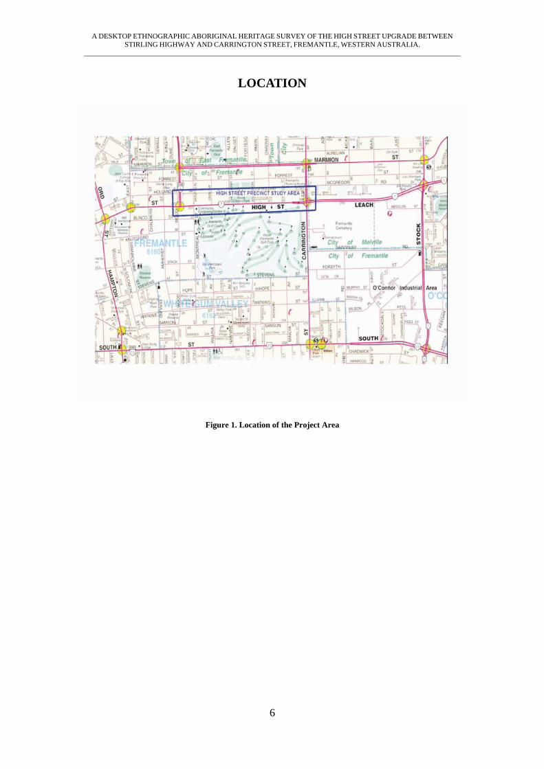
LOCATION
Figure 1. Location of the Project Area
A DESKTOP ETHNOGRAPHIC ABORIGINAL HERITAGE SURVEY OF THE HIGH STREET UPGRADE BETWEEN STIRLING HIGHWAY AND CARRINGTON STREET, FREMANTLE, WESTERN AUSTRALIA.
_______________________________________________________________________________________________________
7
ETHNOGRAPHIC & HISTORICAL BACKGROUND
TRADITIONAL NYUNGAR CULTURE The Bibbulmun Nyungar people share a common language with 13 local dialect variations and inhabit the area to the west of a line drawn roughly from Jurien Bay in the north to Esperance in the south east. Tindale noted that the Swan River area was inhabited by the “Whadjuk”. This group inhabited the lands of the north and eastern tributary inland to Mt Helena at Kalamunda/Armadale to the Victoria Plains south of Toodyay, west to York and south along the coast to Pinjarra (Tindale 1974:260). Traditional initiation practices varied from those of their inland neighbours. The Bibbulmun Nyungars practiced nasal septum piercing and ciatricision (scarring) of the upper body rather than circumcision as an initiation rite (Bates, 1985; Tindale, 1974). These initiation practices have been described by Berndt and Berndt as being of the ‘Old Australian Tradition’ (Berndt and Berndt, 1979). The Bibbulmun Nyungar people recognized two primary moieties, the Manichmat or ‘fair people of the white cockatoo’ and the Wordungmat or ‘dark people of the crow’. These formed the basis for marriage between a further four class subdivisions, the Tondarup, Didarruk and Ballaruk, and Nagarnook. Bates describes the only lawful marriage to be “the cross-cousin marriage of paternal aunts’ children to the maternal uncle’s children”, and states that the four clan groups and relationships, under different names, are “identical in every tribe in Western Australia, east, north, south and south west.” (Bates, 1966; Bates, 1985).
“In Aboriginal societies, most relationships are articulated in kin terms. All activities are carried out in the company of persons who are bound to one another in conventionally defined ways. They not only know what to expect from others, and how they will respond to certain situations, but are reasonably sure that participation and co-operation will be forthcoming if the occasion demands. Over and above the network of obligations and responsibilities linking persons together in, more or less, a mutually satisfying system, there is an atmosphere of familiarity and intimacy possible only in a group which disallows the concept of stranger for anyone within its midst, and even well outside it’s own social limits” (Berndt, 1992).
While Bates saw the Bibbulmun people as being different to other Aboriginal peoples and as representing a distinctive group and even a ‘nation’, more recent anthropologists have emphasized the sameness of all Australian Aboriginal groups and are critical of Bates’ notion of language based ownership of land.
“But although there is so much variation in these rituals, the majority contain some common themes; in simplest terms, removal from the main camp and total or partial enforced segregation; performance of some rite to emphasize the fact of transition; revelation of secrets of a religious nature; and finally, return to the main camp as a social adult.” (Berndt, 1992)
A review of Bates’ writings describes much of her work as a ‘racist muddle’, that she was ‘contemptuous of the growing number of part–Aborigines, who symbolized the cardinal sin of racial miscegenation,’ and that ‘she preached the old doctrine of racial segregation’ (Reece, 1984). The review is critical of her ideology and indicates inadequacies in her methodology. However as Bates’ work represents the most comprehensive and earliest attempt to record Aboriginal culture it is almost invariably referred to. Bates refers to the Perth Bibbulmun as Yabbaru – this term means north. According to Bates it was common amongst the Bibbulmun Nation to name each local group with a term referring to points of the compass. Bates states that all Bibbulmun shared a common language with minor dialectical variations. Within this one nation there was however two forms of descent, the groups on the coast from Jurien Bay to Augusta followed a system of patrilineal descent where as the groups south of the Blackwood
A DESKTOP ETHNOGRAPHIC ABORIGINAL HERITAGE SURVEY OF THE HIGH STREET UPGRADE BETWEEN STIRLING HIGHWAY AND CARRINGTON STREET, FREMANTLE, WESTERN AUSTRALIA.
_______________________________________________________________________________________________________
8
River followed a pattern of matrilineal descent. The Perth groups followed a patrilineal descent system (Bates 1985:46). The Nyungar people traditionally obeyed a recognized system of rights and obligations, transmitted through birth and marriage, which gave individuals rights to the use of and economic benefits of the land over which they also acted as custodians. These areas were significant because they were associated with mythic figures relating to the Aboriginal concept of Dreaming (Silberbauer, 1994; Stanner, 1965). The Dreaming refers to a period of creation when mythical figures transformed the landscape creating hills, lakes, rivers and animals (Machin, 1996). The Waugal is one example of a Dream-time figure which has transformed the landscape as well as infusing it with a living spirit. The Waugal is a creative spirit associated with water and which takes the physical shape of a snake. Bates (1985) recorded stories about Waugal mythology around 1900. Apparently, wherever the Waugal went, it created a river; the Waugal was the creator of all the major rivers in the south west. Wherever the Waugal had stopped or was living was considered to be sacred – winnaitch (Bates, 1985). A ‘winnaitch’ area is a place to avoid. Before using or entering a winnaitch area, Nyungars must perform special rituals. The Waugal is associated with many of the major rivers in the Darling Range as well as many of the smaller springs, swamps, pools and lakes located on the Swan Coastal Plain (O’Connor et al, 1989). Within the Bibbulmun Nyungars, each socio-linguistic group, sometimes referred to as the ‘tribe’, consisted of a number of smaller groups. Each of these smaller groups was made up of around 12 to 30 persons, related men, their wives and children and at times visiting relatives from other groups. These subgroups could be described as a family, a band or a horde. For every subgroup there was a tract of land with which they most closely identified themselves. An individual or a group’s land was called their Kalla or fireplace (Moore, 1884). This referred to an area of land which was used by the group and over which the members of the group exercised the greatest rights to its resources. It was also the area for which the group would act as custodians of. Other groups would also have some rights of access and use gained through marriage.
“Ownership rights to land were held by groups of people linked through common descent; there was definite ownership of land in both social and personal ways. As well as belonging to a local descent group by birth, each individual simultaneously belonged to an economic or food gathering group”. (Le Souef, 1993)
According to Makin (1970) and Brown (1983) early writers such as Symmons (1840), Lyon (1833) and Armstrong (1836) recorded that the Swan River Aborigines maintained a system of land ownership that divided up the country around the Swan River based upon clan groups which had a patrilineal line of descent. From this they were able to produce maps delineating this ownership which, despite some variances, gave an overall understanding of these divisions. Lyons describes the tribal districts in terms of an area name and a single Aboriginal leader (Yellowganga, Manday and Midjegoorang). Armstrong recognized that land appears to be appointed to different families and is not held in common by the tribe (Brown 1983). According to Makin (1970) from Fremantle (Wol-yal-lu) up the river to Butlers Bay (Bi-ri-gap) and then to Mt Eliza (Ea-na-katta) was the land of Yal-gang-ga, his sons, wives and children. From Mt Eliza past the flats (Min-da-rop), near the narrows bridge, to the Peninsula (Wu-nut) to Peter Browns farm at Bassendean was the land of ‘Monday’ (Munday). From the Bassendean ferry jetty to the head of the Swan River was the land of Ngu-nyt. The Canning tribes occupied the left (south) bank of the Swan River and the adjacent Canning River. The land from Fremantle to Preston Point and Point Walter around to Butlers Bay, the entrance to the Canning River, was Djons, Gorbal, Yurjil and Ningara. From the entrance of the Canning River past Mill Point to near Guildford was Bi-non, Yurgan. From Guildford to the head of the Swan River was Mol-li-dabbin, Mol-li-mig-rot and Wib-on and other branches of the family. (Makin 1970; 73-75).
A DESKTOP ETHNOGRAPHIC ABORIGINAL HERITAGE SURVEY OF THE HIGH STREET UPGRADE BETWEEN STIRLING HIGHWAY AND CARRINGTON STREET, FREMANTLE, WESTERN AUSTRALIA.
_______________________________________________________________________________________________________
9
For the Rockingham area, specifically from a line drawn due east from Mangles Bay, extending northwards to the foreshores of the Swan and Canning Rivers was the ‘territory’ of the Beeliar Aboriginal group. This group included the Aboriginal influential Midgegooroo and his son, Yagan. The wetlands in this region were most intensively occupied, given the availability of fresh water and food resources (water foul, turtles, kangaroos etc). Wells were dug close to swamps in order to filter water and some swamp vegetation was consumed. Spears were made from ‘spear wood’ and comprised an important trade item. Pads connected the wetlands and rivers and extended through this territory from the present-day Perth area south to Rockingham, Mandurah and the Murray River. (Ralph, Locke and Smith 1990:8) The Fremantle area was referred to a Walyalup referring to a location as part of the coastal limestone cliffs (Booyeembarra) around the mouth of the Swan Estuary. The Fremantle area had several major dwelling and meeting places and was a place of exchange and ceremony as a mourning place at the mouth of the Swan River. (De Gande & Jackson; 2000) With regards to the Rockingham area various researches such as Machin (1989) and McDonald (2002, 2004) have recorded myths that relate to the creation of Cockburn Sound and the offshore islands Rottnest, Garden Island, Carnac Island and the area of the coast around Mangles Bay, what is now Rotary Park and the adjacent wetlands. These myths were recorded by the above researches as told by Mr Ken Colbung, the primary informant of this creation story. These myths have led to the following sites being placed on the Aboriginal site register, Site ID 3471 – Rotary Park and Site ID 3776 Indian Ocean. These stories had also formerly been recorded in the early 19th century by Moore (1884) and Armstrong (1836) who reported different versions of the same myth. Moore (1884, cited in Brown 1983) records that a great fire was responsible for the creation of the offshore islands:
“The natives have a tradition that Rottnest, Carnac and Garden Island once formed part of the mainland, and that the intervening ground was thickly covered with trees; which took fire in some unaccountable way, and burned with such intensity that the ground split asunder with great noise, and the sea rushed in between cutting off the islands from the mainland”. (Moore 1884)
Armstrong (1836:790) version of the story was recorded as:
“They state, as a fact handed down to them from their ancestors, that Garden Island was formerly united to the main, and that the separation was caused, in some preternatural manner, by the Waugal.” (Armstrong 1836:790)
These versions of the story also substantially differ from that recorded by the above researchers by Mr Ken Colbung whose central figure was a crocodile, not a Waugal. McDonald (2002) explains that if the crocodile in Mr Colbung’s version is read as a Waugal then there is a clear consistency with Mr Colbung’s version of the myth and as recorded by Armstrong. McDonald (2002) has suggested that the inconsistency of the above narratives can be considered anthropologically as a natural part of all myth systems and as noted by Naranda (1972:8) myths often consist of a reorganising of the traditional components in the face of new circumstances and times. McDonald (2002) argues that this is what is happening with the above myth as told by Mr Colbung. McDonald (2002) argues that this is a legitimate part of contemporary Aboriginal people reinterpreting traditional mythological stories by incorporating contemporary and modern beliefs into the versions now being told. (McDonald 2002:8)
A DESKTOP ETHNOGRAPHIC ABORIGINAL HERITAGE SURVEY OF THE HIGH STREET UPGRADE BETWEEN STIRLING HIGHWAY AND CARRINGTON STREET, FREMANTLE, WESTERN AUSTRALIA.
_______________________________________________________________________________________________________
10
ARCHIVAL RESEARCH Archival research involved an examination of the Department of Indigenous Affairs (DIA) Sites Register, a review of any relevant site files, and a review of any unpublished ethnographic reports that relate to the Fremantle area.
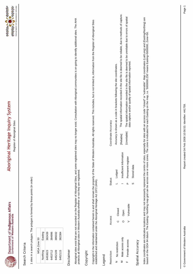
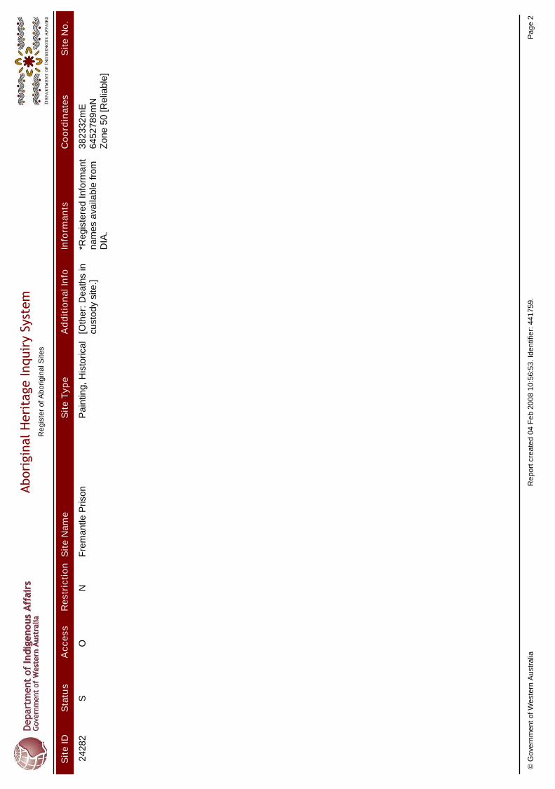
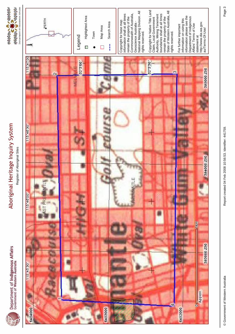
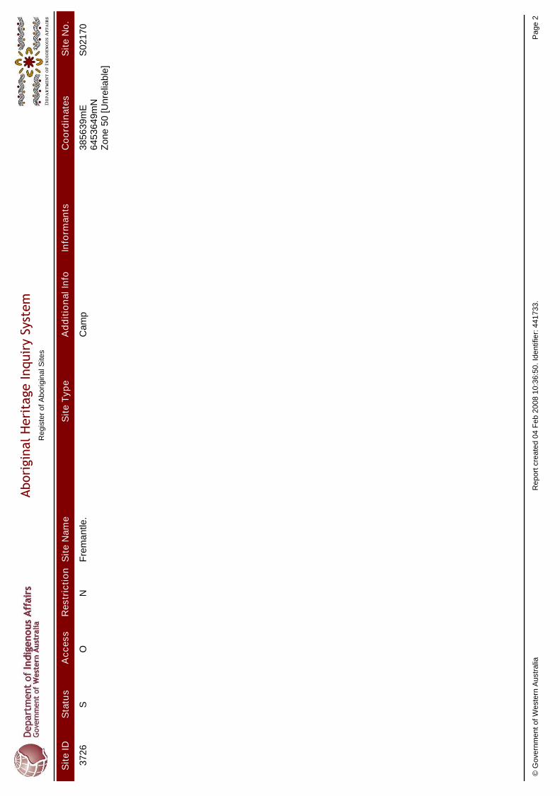
SITES REGISTER SEARCH A search of the DIA Sites Register was conducted on the 4th of February 2008 in order to determine if there were any previously recorded Aboriginal Heritage sites located within the study area. As a result of the search, there are no previously recorded Aboriginal Heritage sites located within the area of the proposed modification of High Street. As a result of the search, the nearest previously recorded Aboriginal Heritage sites are Site ID 24282 Fremantle Prison and Site ID 3726 Fremantle. These sites are located south-west and east of the area of the proposed modifications of High Street and will not be affected by the project proposal as long as the project proposal is constructed as per the current plan. Information regarding these sites locations and extent is provided to the proponent so that the proponent can be aware of these sites should the project proposal be modified. Site ID 24282 Fremantle Prison is located approximately 1km south-west of the intersection of High Street and Stirling Highway. This site has been recorded by the DIA as ‘stored data’ and therefore is no longer deemed as a site under the West Australian Aboriginal Heritage Act (1972). This site is also outside of the project area of proposed works and will not affected by the project proposal as the plan currently stands. Site ID 3726 Fremantle is located approximately 350m east of Carrington Street. This site has also been recorded by the DIA as ‘stored data’ and therefore is no longer deemed as a site under the West Australian Aboriginal Heritage Act (1972). This site is outside of the area of proposed works and will not be affected by the project proposal as the plan currently stands. The name, type and indicative location of the registered heritage Aboriginal sites located within the register search area are shown in table 1. SITE ID.
Status Access Restriction Name Location (AMG Zone 50)*
East North
Site Type
24282 S O N Fremantle Prison
382332mE 6452789mN Painting Historical
3726 S O N Fremantle 385639mE 6453649mN Camp
Table 1 Summary of Registered Aboriginal Heritage Sites located within the Register Search area.
* Please note: Coordinates are indicative locations that represent the centre of sites as shown on maps produced by the DIA – they may not necessarily represent the true centre of all sites.
I – Interim Register, S – Stored Data, P – Permanent Register, O – Access Open, N – File Not Restricted,
REVIEW OF RELEVANT SITE FILES As the above identified sites are outside of the project area and have been accessioned as ‘stored data’ and are no longer protected by the ‘Act’ a review of these site files has not been provided within this report.

A DESKTOP ETHNOGRAPHIC ABORIGINAL HERITAGE SURVEY OF THE HIGH STREET UPGRADE BETWEEN STIRLING HIGHWAY AND CARRINGTON STREET, FREMANTLE, WESTERN AUSTRALIA.
_______________________________________________________________________________________________________
11
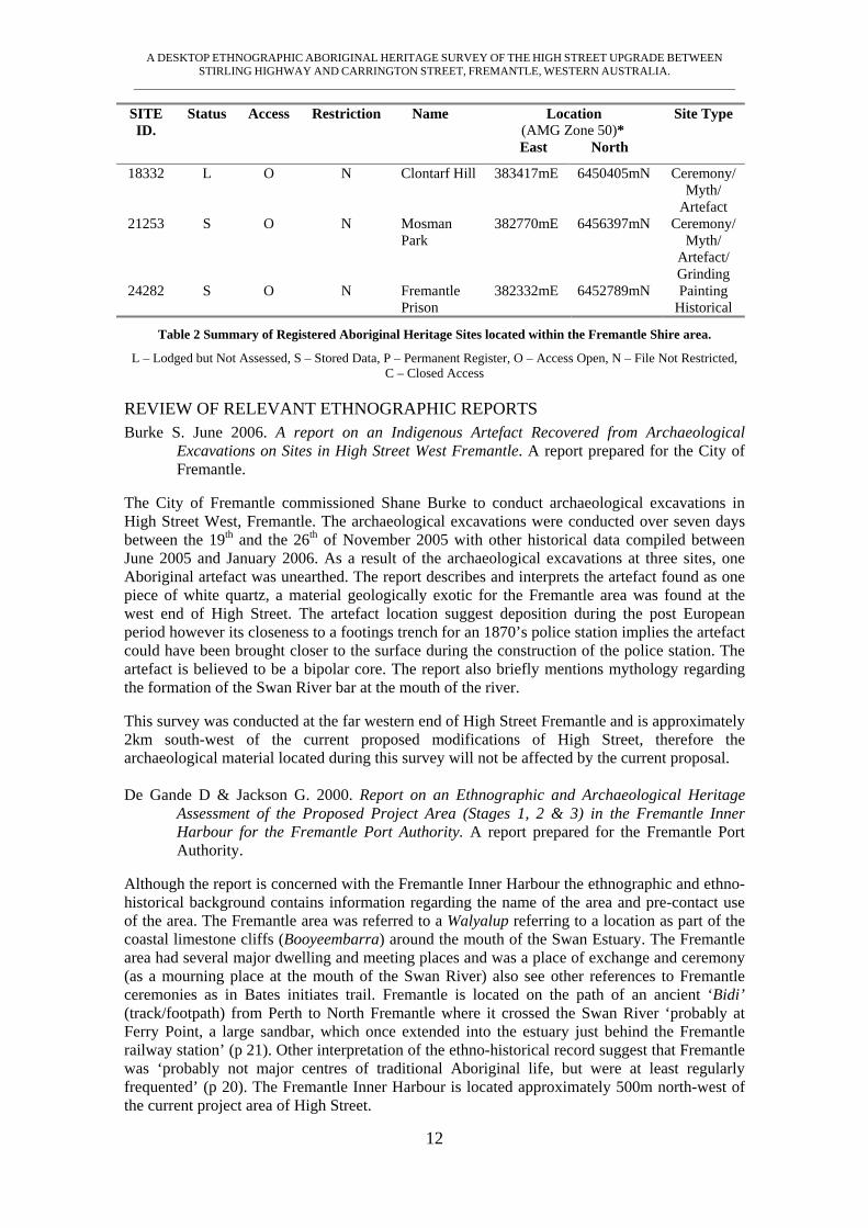
REGISTERED DIA SITES WITHIN THE CITY OF FREMANTLE A search of the DIA sites register within the municipal boundaries of the City of Fremantle revealed 14 previously recorded Aboriginal Heritage Sites. Seven of these sites are classed as traditional Mythological and Ceremonial sites. Three historical camp sites and an additional two camping places associated with the Mythological and Ceremonial sites have also been identified. One artefact scatter and two additional artefact sites associated with the mythological and ceremonial sites, one burial site and one historical painting site are also located. Two of the registered sites do not have a site ‘type’ listed but have been recorded as a named place, meeting place and camp. The search of the area indicates that a considerable record of traditional and post contact Aboriginal Heritage exists in the Fremantle area. It is interesting to note that of the 14 sites 12 are of an ethnographic nature and only two of the sites are of an exclusively archaeological with an additional two archaeological sites associated with the Mythological and Ceremonial sites. In most areas of the south-west region previously recorded archaeological sites usually outnumber ethnographic sites. Within an urban area which has undergone extensive disturbance it is now likely artefact sites have been either covered over or destroyed by development. Ethno-historic records for the area give an indication of considerable pre-historic use and the pre-contact use landscape by Nyungar people. As such one would expect to find a considerable archaeological signature in the area prior to urbanisation. The relatively high number of ethnographic sites indicates that there is a considerable body of ethnographic knowledge and continued heritage interest in the area within the current Nyungar community. As such it would be wise for proponents to consult with the relevant Noongar community members prior to embarking upon large project that will further modify the landscape with particular focus upon areas around the coastal margins, lakes, wetlands and the Swan River. The name, type and indicative location of the registered heritage Aboriginal sites located within the City of Fremantle are shown in table 2.
SITE ID.
Status Access Restriction Name Location (AMG Zone 50)*
East North
Site Type
3419 P O N Fremantle: Cantonment Hill
382525mE 6453972mN Ceremony/ Myth
3420 I O N Fremantle: Anglesea Point
381281mE 6452417mN Named Place
3421 S O N Fremantle: Manjaree
381193mE 6452728mN Meeting Place
3536 P O N Swan River 443400mE 6461957mN Myth 3596 P C N Rocky Bay N/A N/A Myth 3707 P O N Robb Jetty
Camp 382506mE 6449223mN Man Made
Structure 3774 S O N Fremantle:
Arthur Head 381139mE 6452749mN Camp
3775 S O N South Fremantle
382487mE 6454055mN Ceremony/ Myth
3776 S O N Indian Ocean
372624mE 6445362mN Myth
3864 S O N South Fremantle: Attfield
382490mE 6451804mN Artefact
15744 S O N South Fremantle: Francisco St
382387mE 6451748mN Skeletal
A DESKTOP ETHNOGRAPHIC ABORIGINAL HERITAGE SURVEY OF THE HIGH STREET UPGRADE BETWEEN STIRLING HIGHWAY AND CARRINGTON STREET, FREMANTLE, WESTERN AUSTRALIA.
_______________________________________________________________________________________________________
12
SITE ID.
Status Access Restriction Name Location (AMG Zone 50)*
East North
Site Type
18332 L O N Clontarf Hill 383417mE 6450405mN Ceremony/ Myth/
Artefact 21253 S O N Mosman
Park 382770mE 6456397mN Ceremony/
Myth/ Artefact/ Grinding
24282 S O N Fremantle Prison
382332mE 6452789mN Painting Historical
Table 2 Summary of Registered Aboriginal Heritage Sites located within the Fremantle Shire area.
L – Lodged but Not Assessed, S – Stored Data, P – Permanent Register, O – Access Open, N – File Not Restricted, C – Closed Access
REVIEW OF RELEVANT ETHNOGRAPHIC REPORTS Burke S. June 2006. A report on an Indigenous Artefact Recovered from Archaeological
Excavations on Sites in High Street West Fremantle. A report prepared for the City of Fremantle.
The City of Fremantle commissioned Shane Burke to conduct archaeological excavations in High Street West, Fremantle. The archaeological excavations were conducted over seven days between the 19th and the 26th of November 2005 with other historical data compiled between June 2005 and January 2006. As a result of the archaeological excavations at three sites, one Aboriginal artefact was unearthed. The report describes and interprets the artefact found as one piece of white quartz, a material geologically exotic for the Fremantle area was found at the west end of High Street. The artefact location suggest deposition during the post European period however its closeness to a footings trench for an 1870’s police station implies the artefact could have been brought closer to the surface during the construction of the police station. The artefact is believed to be a bipolar core. The report also briefly mentions mythology regarding the formation of the Swan River bar at the mouth of the river. This survey was conducted at the far western end of High Street Fremantle and is approximately 2km south-west of the current proposed modifications of High Street, therefore the archaeological material located during this survey will not be affected by the current proposal. De Gande D & Jackson G. 2000. Report on an Ethnographic and Archaeological Heritage
Assessment of the Proposed Project Area (Stages 1, 2 & 3) in the Fremantle Inner Harbour for the Fremantle Port Authority. A report prepared for the Fremantle Port Authority.
Although the report is concerned with the Fremantle Inner Harbour the ethnographic and ethno-historical background contains information regarding the name of the area and pre-contact use of the area. The Fremantle area was referred to a Walyalup referring to a location as part of the coastal limestone cliffs (Booyeembarra) around the mouth of the Swan Estuary. The Fremantle area had several major dwelling and meeting places and was a place of exchange and ceremony (as a mourning place at the mouth of the Swan River) also see other references to Fremantle ceremonies as in Bates initiates trail. Fremantle is located on the path of an ancient ‘Bidi’ (track/footpath) from Perth to North Fremantle where it crossed the Swan River ‘probably at Ferry Point, a large sandbar, which once extended into the estuary just behind the Fremantle railway station’ (p 21). Other interpretation of the ethno-historical record suggest that Fremantle was ‘probably not major centres of traditional Aboriginal life, but were at least regularly frequented’ (p 20). The Fremantle Inner Harbour is located approximately 500m north-west of the current project area of High Street.

A DESKTOP ETHNOGRAPHIC ABORIGINAL HERITAGE SURVEY OF THE HIGH STREET UPGRADE BETWEEN STIRLING HIGHWAY AND CARRINGTON STREET, FREMANTLE, WESTERN AUSTRALIA.
_______________________________________________________________________________________________________
13
De Gande, D. 2004. Report on an Aboriginal Heritage Assessment of the Proposed Works Area associated with the Inner Harbour Dredging Plan in the Fremantle Inner Harbour for the Fremantle Ports. Report prepared for the Fremantle Ports.
This report detailed the proposal for dredging works within the Fremantle Inner Harbour that would require Section 18 consent under the Western Australian Aboriginal Heritage Act (1972). This report indicates that those consulted for the project were the Combined Metropolitan Working Group (WC99/6) and members of the Ballaruk Native Title Claim (WC95/86) and Mr Patrick Hume, a prominent Aboriginal Elder with a long history of association with the Fremantle area. The Fremantle Inner Harbour is located approximately 500m north-west of the current project area of High Street. McDonald Hales and Associates. August 1997. Aboriginal Heritage Study of the Jervoise Bay
Infrastructure Planning Precinct. A report prepared for Halpern Glick Maunsell. The report identified two new archaeological sites located on the shores of Lake Coogee. It also discusses the potential for burials to occur in coastal dunes. A discussion of archaeological models is also contained in the report. Anderson (1972) has undertaken a synthesis of archaeological research on the Swan Coastal Plain to create a broad regional model. “Groups occupying the Swan Coastal Plain gathered around coastal areas, estuaries, wetlands and drainage points to exploit water based resources in summer and autumn. This activity resulted in the large site characteristic of the Swan Coastal Plain”. In the ethnographic background of the report it is pointed out that between 1927 and 1947 laws restricted Aboriginal people who were ‘not in lawful employment’ from living in towns and many Nyungar people were ‘relocated’ to reserves. Only a few Aboriginal families whose men were employed on the wharves or other industries were able to remain in Fremantle. Aboriginal people lived in fringe camps on the outskirts of town. “....in the Fremantle district...camps were located on disused land ‘at the back of the cemetery’ and at ‘The Smelters’ a sort of skid row shack area that existed south of the town site in the 1930’s and 1940’s (Makin 1970)”. As the proposed road realignment and modification is planned for an area close to the cemetery on Carrington Street it is worth bearing in mind the likelihood of these historic camps extending to the golf course area and other yet to be identified places of ethnographic significance existing in this area. The existence of the Fremantle Golf Club alongside High Street at this location also suggests an area of land that may well have been otherwise unoccupied or unused until recent times and as such could have been a place used by Aboriginal ‘fringe dwellers’ as a camping/living place. This survey was conducted well south of the current proposed modifications of the High Street Fremantle project area and the areas identified in this report will not be affected by the current project. McDonald E. 2003. Ethnographic Survey of the Aboriginal Heritage Values of the Proposed
South Beach Village Development, South Fremantle. A report prepared for South Beach Village Joint Venture Partners.
This survey was commissioned by Land Corp in 2003 for the proposed redevelopment of derelict industrial land to create an urban village between the Ocean and Cockburn Sound in South Fremantle. The project area is bounded by Rollinson Road, Island Street and Robb Road, west of the Fremantle Village and Chalet Centre. The survey concludes that the Robb Jetty camp (Site ID 3707) and the camping place known as the ‘Smelters’ identified by Machin in 1970 are one and the same site. In the Ethno-historical Background Aboriginal people including prisoners released from Rottnest Island originating from remote areas of the state and with no means of returning to their own country lived in camps to the south of Fremantle and were sporadically employed as shepherds and at other work. The report also deals with several myths concerning physical features of the landscape, Woodman Point, and ‘the limestone ridge that runs parallel to and some 200 – 400 metres from the coastline’. This may include the limestone ridge that runs roughly along the route of Hampton Road to around East Street where it intersects the Swan River, placing this feature near to but not within the area of proposed road

A DESKTOP ETHNOGRAPHIC ABORIGINAL HERITAGE SURVEY OF THE HIGH STREET UPGRADE BETWEEN STIRLING HIGHWAY AND CARRINGTON STREET, FREMANTLE, WESTERN AUSTRALIA.
_______________________________________________________________________________________________________
14
modification. Also of interest is reference to a series of campsites recorded by Daisy Bates the form part of the moolyeet (initiate) trail connecting sites in Perth with the Porongurup Ranges. “Other camps on the trail were located at Koorga (variously located by Bates as ‘back of Beaconsfield’ and ‘piggery, burying ground, Fremantle’)” (pg 15). The areas of significance identified in this report are located well to the south of the proposed modification of the High Street Fremantle project and any identified sites will not be affected by the current project. McDonald Hales. 2003. Desktop Survey of the proposed Beach Street Streets Ahead Project,
Fremantle. A report prepared for the City of Fremantle. The report concerns a footpath between Beach Street and Canning Highway. A cautionary note is raised regarding adjacent sites. “Cantonment Hill (Site ID 319) ...border the study area...as mythological sites (...listed as ceremonial) there is the possibility that their boundaries are not as clear cut and as they are close to the study area precautions should be taken so that these sites are not disturbed” (p 21). This is another indication that both mundane (camping, historical) and mythological sites with possibly unclear boundaries exist in the immediate environs of the proposed Fremantle High Street road modification. The Beach Street and Canning Highway footpaths are located approximately 1km north-west of the current project modifications of Fremantle High Street and as such it may be necessary to consult with representatives of the Nyungar community in order to make sure these sites do not extend to the current development area. McDonald, E. 2004. Desktop Survey of the Aboriginal Heritage Values of the South Fremantle
Power Station and Switch Yard Sites. Report prepared for LandCorp. The South Fremantle Power Station and the adjacent Switch Yard sites are located in one of three geological zones identified and referred to by Nyungars as ‘Booyeembara’. A number of Nyungar myths have been recorded in Cockburn and surrounding areas. One narrative relates as follows:
“In the Nyitting, Meeka was the only one who had fire; all of the other animals and Nyungar (people) were cold and had to eat raw meat. Each day Meeka rested in a round hole in the earth, which, according to the informant, is located …. near North Lake. The sparrow and hawk flew to Meeka’s resting place and stole a fire-stick. They then flew along the limestone ridge where the bush caught fire. The Moon called in its uncle, Waddarn, the sea, for help. The sea rose to extinguish the fire. Many Nyungars, according to the narrative, were drowned and the lakes in the area were formed, including Lake Coogee. However, Nyungars retain the fire and Meeka was cold from that time on.” (pg 4, 5)
These mythological stories indicate that Cockburn and surrounding areas such as Coogee and Fremantle were occupied and utilised by traditional Nyungars prior to European settlement and that in the post contact period a considerable body of traditional mythological knowledge has survived with regards to significant sites in the area. This survey was conducted well south of the current proposed modifications of the High Street Fremantle and sites identified in this report will not be affected by the current project. O’Connor, S. and Thompson, R. 1984. Report on an Investigation into the Aboriginal Heritage
of the Arthur Head Area, Fremantle. Report prepared for the Fremantle City Council. This report provided details of past Aboriginal usage of the Arthur Head area within Fremantle, particularly Bathers Bay. Historical records indicate that regular visitation by Aborigines in the Fremantle area took place during European settlement era. Arthur Head was described as being in proximity to a good source of freshwater, the coast, river and swamps and would have made an attractive campsite. The whaling season in Fremantle also saw a large number of Aborigines gathering at Bathers Bay to feast on the scraps left from whaling activities. The report concluded that any land disturbance to Bathers Bay should not be allowed without a controlled
A DESKTOP ETHNOGRAPHIC ABORIGINAL HERITAGE SURVEY OF THE HIGH STREET UPGRADE BETWEEN STIRLING HIGHWAY AND CARRINGTON STREET, FREMANTLE, WESTERN AUSTRALIA.
_______________________________________________________________________________________________________
15
excavation. It was recommended that if any earth works took place that this should include the investigations of Aboriginal usage of the area. Bathers Bay is located at the most western point of High Street, however the current proposed modification of High Street Fremantle is located approximately 1.5km north-east of Bathers Bay and will not be impacted upon by the project proposal.
RESULTS OF ARCHIVAL RESEARCH Archival research has revealed that there is a rich record of pre-European and post contact Nyungar occupation of the Fremantle area. The area now subject to this study does not contain any previously recorded Aboriginal Heritage sites but has not been previously surveyed. Several adjacent studies (Burke 2006, McDonald 1997, 2003, 2004 and O’Connor and Thompson 1984) to the survey area do exist and point to a rich record of heritage sites recorded in the region. Few pre-historic artefact sites have been recorded in Fremantle which is largely a result of the fact that the area has undergone high degrees of disturbance from urbanization which has destroyed or concealed the archaeological signature. Some potential for artefacts to be unearthed during excavation and earthworks remains in areas around the coastal margin, lakes and the Swan River. (Burke 2006). Ethno-historical research indicates that Fremantle was formerly known as Walyalup and that it was a major meeting and dwelling place for traditional Nyungar people and was known as a place for undertaking trade and ceremonies. Fremantle was a place the Swan River could be crossed and so was an important link on a Bidi (track) that ran from Perth to the south of the river and beyond (De Gande, 2000; see also Bates in McDonald 2003). Several landscape features in the Fremantle area are identified as having mythological significance. The Limestone Ridge near Coogee that runs parallel with the coastline was reported to be mythologically created as was Lake Coogee (McDonald 2003). Mention is also made of an initiate’s camp near the ‘burying ground’ in Fremantle by Bates (McDonald 2003). With regards to these mythological sites a cautionary note is sounded by McDonald regarding boundaries that are unclear and that may be extended beyond what has been previously mapped (McDonald; 2003). During the historical period Aboriginal people lived in fringe camps around the Fremantle area and appear to have been concentrated to the south around Robs Jetty (the Smelters). The area around the Fremantle Cemetery is also identified as a location Aboriginal people camped in during the historical period (McDonald 1997, 2003). This may have some relevance to our current project as it appears Nyungars were targeting undeveloped land to establish fringe camps late in history. The area where the golf course is bordering High Street may be such a place depending upon its land use prior to it becoming a golf course. Only consultations with Nyungar people could establish this. As the project is to affect land that is now a road and an urban area it is not likely that areas of heritage significance will be affected. As adjacent land to High Street has undergone surveys in the past and no major ethnographic sites have been recorded it is not likely that the area under consideration would now contain any places of current heritage significance. However at a desktop level this is impossible to determine with any certainty. Only consultation with knowledgeable Nyungars such as Mr Patrick Hume who is now 85 years of age and has spent his life in the area can establish with certainty that no sites now exist in the area where the High Street upgrade will take place.
A DESKTOP ETHNOGRAPHIC ABORIGINAL HERITAGE SURVEY OF THE HIGH STREET UPGRADE BETWEEN STIRLING HIGHWAY AND CARRINGTON STREET, FREMANTLE, WESTERN AUSTRALIA.
_______________________________________________________________________________________________________
16
NATIVE TITLE CLAIMS OVERLAPPING THE FREMANTLE AREA
Currently, there are two unregistered Native Title applications that overlays the project area, lodged with the Register of Native Title Claims and the Schedule of Applications held by the Commonwealth Native Title Tribunal. The Schedule of Applications includes registered applications, unregistered applications, and applications still undergoing the registration test.
• Single Noongar Claim (Area 1) WC03/6
Applicants: Anthony Bennell, Alan Blurton, Alan Bolton, Martha Borinelli, Robert Bropho, Glen Colbung, Donald Collard, Clarrie Collard-Ugle, Albert Corunna, Shawn Councillor, Dallas Coyne, Dianne Coyne, Margaret Colbung, Edith De Giambattista, Rita Dempster, Aden Eades, Trevor Eades, Doolann-Leisha Eattes, Essard Flowers, Greg Garlett, John Garlett, Ted Hart, George Hayden, Reg Hayden, John Hayden, Val Headland, Eric Hayward, Jack Hill, Oswald Humphries, Robert Isaacs, Allan Jones, James Khan, Justin Kickett, Eric Krakouer, Barry McGuire, Wally McGuire, Winnie McHenry, Peter Michael, Theodore Michael, Samuel Miller, Diane Mippy, Fred Mogridge, Harry Narkle, Doug Nelson, Joe Northover, Clive Parfitt, John Pell, Kathleen Penny, Carol Pettersen, Fred Pickett, Rosemary Pickett, Phillip Prosser, Bill Reidy, Robert Riley, Lomas Roberts, Mal Ryder, Ruby Ryder, Charlie Shaw, Iris Slater, Barbara Stamner-Corbett, Harry Thorne, Angus Wallam, Charmaine Walley, Joseph Walley, Richard Walley, Trevor Walley, William Warrell, William Webb, Beryl Weston, Bertram Williams, Gerald Williams, Richard Wilkes, Mervyn Winmar, Andrew Woodley, Humphrey Woods, Dianne Yappo, Reg Yarran, Saul Yarran, Myrtle Yarran, Ken Colbung.
• Ballaruks Peoples WC95/86
Applicants: Mr Christopher Robert Bodney, The applicant claims on behalf of the Native Title Claim group known as the Ballaruk and Didjarruk People. The claim group consists of the biological descendants of the union between Melba Armitage (Bluffie) and William Bodney. Specifically excluded from the claim group is William Lucas Bodney.
“Please note that at the April 2007 appeal hearing into the 2006 decision in the Single Noongar Claim (Area One), Justice Wilcox ordered that a substantial portion of the area claimed by the Ballaruks peoples be dismissed. The area of the Ballaruks claim dismissed by Justice Wilcox was that which lay over the Perth metropolitan area. The result of that decision is that the only remaining native title claim over the Perth metropolitan region is the Single Noongar Claim (Area one) WC03/6 WAD 6006/2003. Single Noongar Claim is not a registered native title claim. It is worth noting that Justice Wilcox’s decision is currently being appealed. There is no timeframe for the completion of this appeal process. Please also be aware, however, that native title has not yet been determined under the Native Title Act 1993 over this area. Further questions such as the level of extinguishment of native title within the claim area and what final form the native title rights and interest will take in relation to others have still to be determined.” (email dated 13/3/08 from Imogen Jeffreys; National Native Title Tribunal, Ballaruks Case Manger)
A DESKTOP ETHNOGRAPHIC ABORIGINAL HERITAGE SURVEY OF THE HIGH STREET UPGRADE BETWEEN STIRLING HIGHWAY AND CARRINGTON STREET, FREMANTLE, WESTERN AUSTRALIA.
_______________________________________________________________________________________________________
17
With regards to appropriate Nyungar organisations and families to consult for the project area, the Department of Indigenous Affairs and South West Aboriginal Land and Sea Council (SWALSC) have advised that normal protocol would require the following Aboriginal groups and families to be consulted in the High Street area: 1) Combined Metro Working Group (Single Noongar Claim) which represents the following families:
• Bropho • Worrell • Garlett • Wilkes • Corunna
2) The Metropolitan Aboriginal Environment Group:
• Patrick Hume • Lena Crab • Ken Colbung • Esandra Colbung • Phillip Prosser
3) The Reverend Cedric Jacobs Family 4) Ballaruks People Native Title Claim Group:
• Corrie Bodney and Family
A DESKTOP ETHNOGRAPHIC ABORIGINAL HERITAGE SURVEY OF THE HIGH STREET UPGRADE BETWEEN STIRLING HIGHWAY AND CARRINGTON STREET, FREMANTLE, WESTERN AUSTRALIA.
_______________________________________________________________________________________________________
18
RECOMMENDATIONS As a result of this desktop report it is recommended that the upgrade to High Street can proceed as planned as no previously recorded Aboriginal Heritage sites have been identified to be in conflict with the project plans. It is further recommended that should the project plans identify a need to affect areas to the east or west of the area currently identified for works that a full Aboriginal Heritage survey which would include archaeological inspections and consultations with the appropriate Aboriginal groups be conducted. Areas of particular focus for such a survey would be in the vicinity of the Fremantle Cemetery, an area known as a historic camp ground. It is also recommended that if the current plans require significant works that affect the golf course that the proponents conduct consultations with local Aboriginal representatives that would be able to determine if these camps extended west from the Cemetery into this area.
A DESKTOP ETHNOGRAPHIC ABORIGINAL HERITAGE SURVEY OF THE HIGH STREET UPGRADE BETWEEN STIRLING HIGHWAY AND CARRINGTON STREET, FREMANTLE, WESTERN AUSTRALIA.
_______________________________________________________________________________________________________
19
BIBLIOGRAPHY Armstrong, 1836 (pg790) Cited in Brown, S.H. 1983. A Survey for Aboriginal Sites,
Ethnographic Investigations Elating to some Proposed Highway and Road Developments in the Perth Metropolitan Area. Prepared for Main Roads Department
Bates, D. 1966. The Passing of the Aborigines. John Murray: London. Bates, D. 1985. The Native Tribes of Western Australia. I. White (Ed.). National Library of
Australia, Canberra. Berndt, R. M. and Berndt, C. H. (Eds). 1979. Aborigines of the West: Their Past & Their
Present. University of Western Australia Press: Perth. Berndt, R.M. 1992. The World of the First Australians: Aboriginal Traditional Life, Past and
Present. Australian Institute of Aboriginal Studies: Canberra. Brown, S.H. 1983. A Survey for Aboriginal Sites, Ethnographic Investigations Elating to some
Proposed Highway and Road Developments in the Perth Metropolitan Area. Prepared for Main Roads Department
Burke S. June 2006. A report on an Indigenous Artefact Recovered from Archaeological
Excavations on Sites in High Street West Fremantle. A report prepared for the City of Fremantle.
De Gande D & Jackson G. 2000. Report on an Ethnographic and Archaeological Heritage
Assessment of the Proposed Project Area (Stages 1,2 & 3) in the Fremantle Inner Harbour for the Fremantle Port Authority. A report prepared for the Fremantle Port Authority.
De Gande, D. 2004. Report on an Aboriginal Heritage Assessment of the Proposed Works Area
associated with the Inner Harbour Dredging Plan in the Fremantle Inner Harbour for the Fremantle Ports. Report prepared for the Fremantle Ports.
Le Souef, S. 1993. The Aborigines of King George Sound at the Time of Early European
Contact: An Ethnohistorical Study of Social Organisation and Territoriality. In: de Garis, B.K. (Ed.). Portraits of the Southwest: Aborigines, Women and the Environment. University of Western Australia Press, Perth.
Lyon, R.M. 1833. A Glance at the Manners and Language of the Aboriginal inhabitants of
Western Australia, with a short vocabulary. The Perth Gazette, March Reprinted in Green, N. 1979.
Machin, B. 1996. Ethnographic Report: Aboriginal Heritage Survey – Albany – Lake Grace
Road Amelup Section SLK 83.5 to SLK 87.0. Unpublished report for the Main Roads Department, Perth.
Machin, B 1989. Report of an Ethnographic Survey of the Mangles Bay Marina Development.
Report prepared for the Department of Marin and Harbour. Makin, C. F. 1970. Socio-Economic Anthropological Survey of People of Aboriginal Descent in
the Metropolitan Region of Perth, Western Australia. An unpublished degree of Doctor of Philosophy of the University of Western Australia.
McDonald Hales. August 2003. Desktop Survey of the proposed Beach Street Streets Ahead
Project, Fremantle. A report prepared for the City of Fremantle.
A DESKTOP ETHNOGRAPHIC ABORIGINAL HERITAGE SURVEY OF THE HIGH STREET UPGRADE BETWEEN STIRLING HIGHWAY AND CARRINGTON STREET, FREMANTLE, WESTERN AUSTRALIA.
_______________________________________________________________________________________________________
20
Mc Donald E. December 2003. Ethnographic Survey of the Aboriginal Heritage Values of the
Proposed South Beach Village Development, South Fremantle. A report prepared for South Beach Village Joint Venture Partners.
McDonald Hales and Associates. August 1997. Aboriginal Heritage Study of the Jervoise Bay
Infrastructure Planning Precinct. A report prepared for Halpern Glick Maunsell. McDonald, E. 2004. Desktop Survey of the Aboriginal Heritage Values of the South Fremantle
Power Station and Switch Yard Sites. Report prepared for LandCorp. McDonald Hales and Associates. 2002. An Ethnographic Survey of the Proposed Concept Plan
for the Redevelopment of Rotary Park, Rockingham, Western Australian. Report Prepared for the City of Rockingham.
Moore, G.F. 1884. Diary of Ten Years of Eventful Life of an Early Settler in Western Australia.
M. Walbrook: London. O’Connor, R., Quartermaine, G. and Bodney, C. 1989. Report on an Investigation into the
Aboriginal Significance of Wetlands and Rivers in the Perth – Bunbury Region. Western Australian Water Resources Council.
O’Connor, S. and Thompson, R. 1984. Report on an Investigation into the Aboriginal Heritage
of the Arthur Head Area, Fremantle. Report prepared for the Fremantle City Council. Ralph, Locke & Smith. 1990. Report of an Aboriginal Sites Survey of IP14 – East Rockingham
Industrial Park. Report Prepared for Dames and Moore and the Department of Resources Development.
Reece, B. 1984. Prisoners in Their Own Country: Aborigines in Western Australian Historical
Writing. In: Reece, B. and Stannage, T. (Eds.). European – Aboriginal Relations in Western Australian History. Department of History, University of Western Australia, Nedlands.
Silberbauer, G. B. 1994. A Sense of Place. In: Burch, E.S.J and Ellena, L.J. Eds. Key Issues
in Hunter-Gatherer Research. Oxford: Berg Stanner, W. 1965. Aboriginal Territorial Organisation: Estate, Range, Domain and Regime.
Oceania, 33(1). Tindale, N. B., 1974. Aboriginal Tribes in Australia. University of California Press, Berkley,
U.S.A.
A DESKTOP ETHNOGRAPHIC ABORIGINAL HERITAGE SURVEY OF THE HIGH STREET UPGRADE BETWEEN STIRLING HIGHWAY AND CARRINGTON STREET, FREMANTLE, WESTERN AUSTRALIA.
_______________________________________________________________________________________________________
21
APPENDIX 1. SITES REGISTER SEARCH
1 s
ites
in a
se
arc
h p
oly
go
n.
Th
e p
oly
go
n is
fo
rme
d b
y th
ese
po
ints
(in
ord
er)
:
Se
arc
h C
rite
ria
No
rth
ing
Ea
stin
g
MG
A Z
on
e 5
0
64
53
62
33
82
43
9
64
53
71
23
84
99
6
64
52
10
93
85
03
2
64
52
11
53
82
38
4
N M F
No
re
stri
ctio
n
Ma
le a
cce
ss o
nly
Fe
ma
le a
cce
ss
Le
ge
nd
I S
Insu
ffic
ien
t In
form
atio
n
Pe
rma
ne
nt
reg
iste
r
Sto
red
da
ta
C O V
Clo
sed
Op
en
Vu
lne
rab
le
[Re
liab
le]
[Un
relia
ble
]
Th
e s
pa
tial i
nfo
rma
tion
re
cord
ed
in t
he
site
file
is d
ee
me
d t
o b
e r
elia
ble
, d
ue
to
me
tho
ds
of
cap
ture
.
Th
e s
pa
tial i
nfo
rma
tion
re
cord
ed
in t
he
site
file
is d
ee
me
d t
o b
e u
nre
liab
le d
ue
to
err
ors
of
spa
tial
da
ta c
ap
ture
an
d/o
r q
ua
lity
of
spa
tial i
nfo
rma
tion
re
po
rte
d.
Re
str
icti
on
Sta
tus
Ac
ce
ss
Co
ord
ina
te A
cc
ura
cy
Acc
ura
cy is
sh
ow
n a
s a
co
de
in b
rack
ets
fo
llow
ing
th
e s
ite c
oo
rdin
ate
s.
Dis
cla
ime
r
Ab
ori
gin
al s
ites
exi
st t
ha
t a
re n
ot
reco
rde
d o
n t
he
Re
gis
ter
of
Ab
ori
gin
al S
ites,
an
d s
om
e r
eg
iste
red
site
s m
ay
no
lon
ge
r e
xist
. C
on
sulta
tion
with
Ab
ori
gin
al c
om
mu
niti
es
is o
n-g
oin
g t
o id
en
tify
ad
diti
on
al s
ites.
Th
e A
HA
p
rote
cts
all
Ab
ori
gin
al s
ites
in W
est
ern
Au
stra
lia w
he
the
r o
r n
ot
the
y a
re r
eg
iste
red
.
Ind
ex
coo
rdin
ate
s a
re in
dic
ativ
e lo
catio
ns
an
d m
ay
no
t n
ece
ssa
rily
re
pre
sen
t th
e c
en
tre
of
site
s, e
spe
cia
lly f
or
site
s w
ith a
n a
cce
ss c
od
e “
clo
sed
” o
r “v
uln
era
ble
”. M
ap
co
ord
ina
tes
(La
t/L
on
g)
an
d (
Ea
stin
g/N
ort
hin
g)
are
b
ase
d o
n th
e G
DA
94
da
tum
. T
he
Ea
stin
g /
No
rth
ing
ma
p g
rid
ca
n b
e a
cro
ss o
ne
or
mo
re z
on
es.
Th
e z
on
e is
ind
ica
ted
fo
r e
ach
Ea
stin
g o
n t
he
ma
p,
i.e.
'50
00
00
0:Z
50
' me
an
s E
ast
ing
=5
00
00
00
, Z
on
e=
50
.
Sp
ati
al
Ac
cu
rac
y
Co
py
rig
ht
Co
pyr
igh
t in
th
e in
form
atio
n c
on
tain
ed
he
rein
is a
nd
sh
all
rem
ain
th
e p
rop
ert
y o
f th
e S
tate
of
We
ste
rn A
ust
ralia
. A
ll ri
gh
ts r
ese
rve
d.
Th
is in
clu
de
s, b
ut
is n
ot
limite
d t
o,
info
rma
tion
fro
m t
he
Re
gis
ter
of
Ab
ori
gin
al S
ites
est
ab
lish
ed
an
d m
ain
tain
ed
un
de
r th
e A
bo
rig
ina
l He
rita
ge
Act
19
72
(A
HA
).
LL
od
ge
d
P
Re
gis
ter
of
Ab
ori
gin
al S
ites
Abori
gin
al H
eri
tage Inquir
y Sy
stem
© G
ove
rnm
en
t o
f W
est
ern
Au
stra
liaR
ep
ort
cre
ate
d 0
4 F
eb
20
08
10
:56
:53
. Id
en
tifie
r: 4
41
75
9.
Pa
ge
1
Sit
e I
DS
tatu
sA
cc
es
sR
es
tric
tio
nS
ite
Na
me
Sit
e T
yp
eA
dd
itio
na
l In
foIn
form
an
tsC
oo
rdin
ate
sS
ite
No
.
24
28
2F
rem
an
tle P
riso
nO
SP
ain
ting
, H
isto
rica
l3
82
33
2m
E
64
52
78
9m
N
Zo
ne
50
[R
elia
ble
]
[Oth
er:
De
ath
s in
cu
sto
dy
site
.]*R
eg
iste
red
In
form
an
t n
am
es
ava
ilab
le f
rom
D
IA.
N
Re
gis
ter
of
Ab
ori
gin
al S
ites
Abori
gin
al H
eri
tage Inquir
y Sy
stem
© G
ove
rnm
en
t o
f W
est
ern
Au
stra
liaR
ep
ort
cre
ate
d 0
4 F
eb
20
08
10
:56
:53
. Id
en
tifie
r: 4
41
75
9.
Pa
ge
2
Re
gis
ter
of
Ab
ori
gin
al S
ites
Abori
gin
al H
eri
tage Inquir
y Sy
stem
Le
ge
nd
To
wn
Hig
hlig
hte
d A
rea
Ma
p A
rea
Se
arc
h A
rea
Co
pyr
igh
t fo
r b
ase
ma
p
info
rma
tion
sh
all
at
all
time
s re
ma
in t
he
pro
pe
rty
of
the
C
om
mo
nw
ea
lth o
f A
ust
ralia
, G
eo
scie
nce
Au
stra
lia -
N
atio
na
l Ma
pp
ing
Div
isio
n.
All
rig
hts
re
serv
ed
.
Co
pyr
igh
t fo
r N
ativ
e T
itle
La
nd
C
laim
, L
oca
l Go
vern
me
nt
Au
tho
rity
, M
inin
g T
en
em
en
t b
ou
nd
ari
es
sha
ll a
t a
ll tim
es
rem
ain
th
e p
rop
ert
y o
f th
e
Sta
te o
f W
est
ern
Au
stra
lia,
All
rig
hts
re
serv
ed
.
Fo
r fu
rth
er
imp
ort
an
t in
form
atio
n o
n u
sin
g t
his
in
form
atio
n p
lea
se s
ee
th
e
De
pa
rtm
en
t o
f In
dig
en
ou
s A
ffa
irs’
Te
rms
of
Use
st
ate
me
nt
at
htt
p:/
/ww
w.d
ia.w
a.g
ov.
au
/Te
rms-
Of-
Use
/
© G
ove
rnm
en
t o
f W
est
ern
Au
stra
liaR
ep
ort
cre
ate
d 0
4 F
eb
20
08
10
:56
:53
. Id
en
tifie
r: 4
41
75
9.
Pa
ge
3

1 s
ites
in a
se
arc
h b
ox.
Th
e b
ox
is f
orm
ed
by
the
se d
iag
on
ally
op
po
sed
co
rne
r p
oin
ts:
Se
arc
h C
rite
ria
No
rth
ing
Ea
stin
g
MG
A Z
on
e 5
0
64
54
00
03
83
00
0
64
52
00
03
86
00
0
N M F
No
re
stri
ctio
n
Ma
le a
cce
ss o
nly
Fe
ma
le a
cce
ss
Le
ge
nd
I S
Insu
ffic
ien
t In
form
atio
n
Pe
rma
ne
nt
reg
iste
r
Sto
red
da
ta
C O V
Clo
sed
Op
en
Vu
lne
rab
le
[Re
liab
le]
[Un
relia
ble
]
Th
e s
pa
tial i
nfo
rma
tion
re
cord
ed
in t
he
site
file
is d
ee
me
d t
o b
e r
elia
ble
, d
ue
to
me
tho
ds
of
cap
ture
.
Th
e s
pa
tial i
nfo
rma
tion
re
cord
ed
in t
he
site
file
is d
ee
me
d t
o b
e u
nre
liab
le d
ue
to
err
ors
of
spa
tial
da
ta c
ap
ture
an
d/o
r q
ua
lity
of
spa
tial i
nfo
rma
tion
re
po
rte
d.
Re
str
icti
on
Sta
tus
Ac
ce
ss
Co
ord
ina
te A
cc
ura
cy
Acc
ura
cy is
sh
ow
n a
s a
co
de
in b
rack
ets
fo
llow
ing
th
e s
ite c
oo
rdin
ate
s.
Dis
cla
ime
r
Ab
ori
gin
al s
ites
exi
st t
ha
t a
re n
ot
reco
rde
d o
n t
he
Re
gis
ter
of
Ab
ori
gin
al S
ites,
an
d s
om
e r
eg
iste
red
site
s m
ay
no
lon
ge
r e
xist
. C
on
sulta
tion
with
Ab
ori
gin
al c
om
mu
niti
es
is o
n-g
oin
g t
o id
en
tify
ad
diti
on
al s
ites.
Th
e A
HA
p
rote
cts
all
Ab
ori
gin
al s
ites
in W
est
ern
Au
stra
lia w
he
the
r o
r n
ot
the
y a
re r
eg
iste
red
.
Ind
ex
coo
rdin
ate
s a
re in
dic
ativ
e lo
catio
ns
an
d m
ay
no
t n
ece
ssa
rily
re
pre
sen
t th
e c
en
tre
of
site
s, e
spe
cia
lly f
or
site
s w
ith a
n a
cce
ss c
od
e “
clo
sed
” o
r “v
uln
era
ble
”. M
ap
co
ord
ina
tes
(La
t/L
on
g)
an
d (
Ea
stin
g/N
ort
hin
g)
are
b
ase
d o
n th
e G
DA
94
da
tum
. T
he
Ea
stin
g /
No
rth
ing
ma
p g
rid
ca
n b
e a
cro
ss o
ne
or
mo
re z
on
es.
Th
e z
on
e is
ind
ica
ted
fo
r e
ach
Ea
stin
g o
n t
he
ma
p,
i.e.
'50
00
00
0:Z
50
' me
an
s E
ast
ing
=5
00
00
00
, Z
on
e=
50
.
Sp
ati
al
Ac
cu
rac
y
Co
py
rig
ht
Co
pyr
igh
t in
th
e in
form
atio
n c
on
tain
ed
he
rein
is a
nd
sh
all
rem
ain
th
e p
rop
ert
y o
f th
e S
tate
of
We
ste
rn A
ust
ralia
. A
ll ri
gh
ts r
ese
rve
d.
Th
is in
clu
de
s, b
ut
is n
ot
limite
d t
o,
info
rma
tion
fro
m t
he
Re
gis
ter
of
Ab
ori
gin
al S
ites
est
ab
lish
ed
an
d m
ain
tain
ed
un
de
r th
e A
bo
rig
ina
l He
rita
ge
Act
19
72
(A
HA
).
LL
od
ge
d
P
Re
gis
ter
of
Ab
ori
gin
al S
ites
Abori
gin
al H
eri
tage Inquir
y Sy
stem
© G
ove
rnm
en
t o
f W
est
ern
Au
stra
liaR
ep
ort
cre
ate
d 0
4 F
eb
20
08
10
:36
:50
. Id
en
tifie
r: 4
41
73
3.
Pa
ge
1
Sit
e I
DS
tatu
sA
cc
es
sR
es
tric
tio
nS
ite
Na
me
Sit
e T
yp
eA
dd
itio
na
l In
foIn
form
an
tsC
oo
rdin
ate
sS
ite
No
.
37
26
S0
21
70
Fre
ma
ntle
.O
S3
85
63
9m
E
64
53
64
9m
N
Zo
ne
50
[U
nre
liab
le]
Ca
mp
N
Re
gis
ter
of
Ab
ori
gin
al S
ites
Abori
gin
al H
eri
tage Inquir
y Sy
stem
© G
ove
rnm
en
t o
f W
est
ern
Au
stra
liaR
ep
ort
cre
ate
d 0
4 F
eb
20
08
10
:36
:50
. Id
en
tifie
r: 4
41
73
3.
Pa
ge
2
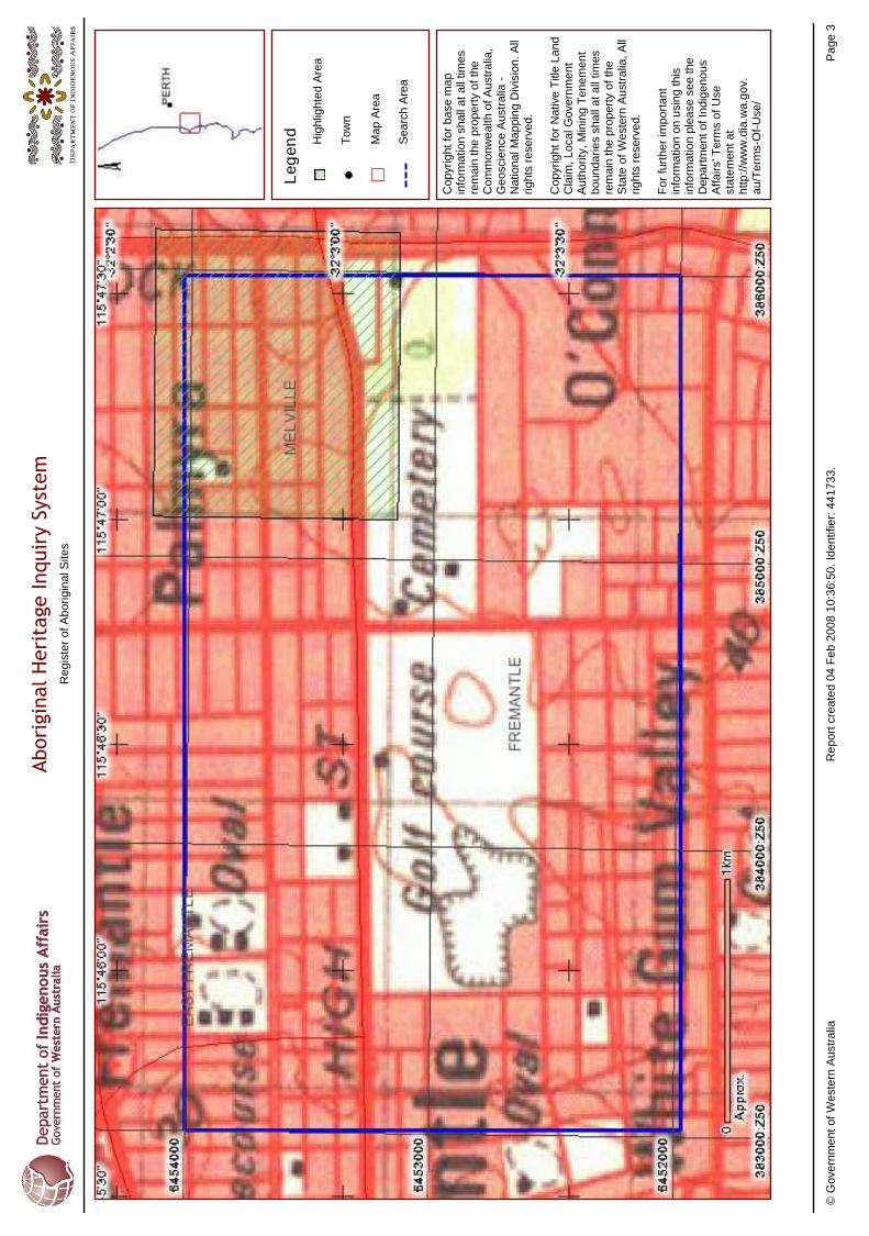
Re
gis
ter
of
Ab
ori
gin
al S
ites
Abori
gin
al H
eri
tage Inquir
y Sy
stem
Le
ge
nd
To
wn
Hig
hlig
hte
d A
rea
Ma
p A
rea
Se
arc
h A
rea
Co
pyr
igh
t fo
r b
ase
ma
p
info
rma
tion
sh
all
at
all
time
s re
ma
in t
he
pro
pe
rty
of
the
C
om
mo
nw
ea
lth o
f A
ust
ralia
, G
eo
scie
nce
Au
stra
lia -
N
atio
na
l Ma
pp
ing
Div
isio
n.
All
rig
hts
re
serv
ed
.
Co
pyr
igh
t fo
r N
ativ
e T
itle
La
nd
C
laim
, L
oca
l Go
vern
me
nt
Au
tho
rity
, M
inin
g T
en
em
en
t b
ou
nd
ari
es
sha
ll a
t a
ll tim
es
rem
ain
th
e p
rop
ert
y o
f th
e
Sta
te o
f W
est
ern
Au
stra
lia,
All
rig
hts
re
serv
ed
.
Fo
r fu
rth
er
imp
ort
an
t in
form
atio
n o
n u
sin
g t
his
in
form
atio
n p
lea
se s
ee
th
e
De
pa
rtm
en
t o
f In
dig
en
ou
s A
ffa
irs’
Te
rms
of
Use
st
ate
me
nt
at
htt
p:/
/ww
w.d
ia.w
a.g
ov.
au
/Te
rms-
Of-
Use
/
© G
ove
rnm
en
t o
f W
est
ern
Au
stra
liaR
ep
ort
cre
ate
d 0
4 F
eb
20
08
10
:36
:50
. Id
en
tifie
r: 4
41
73
3.
Pa
ge
3
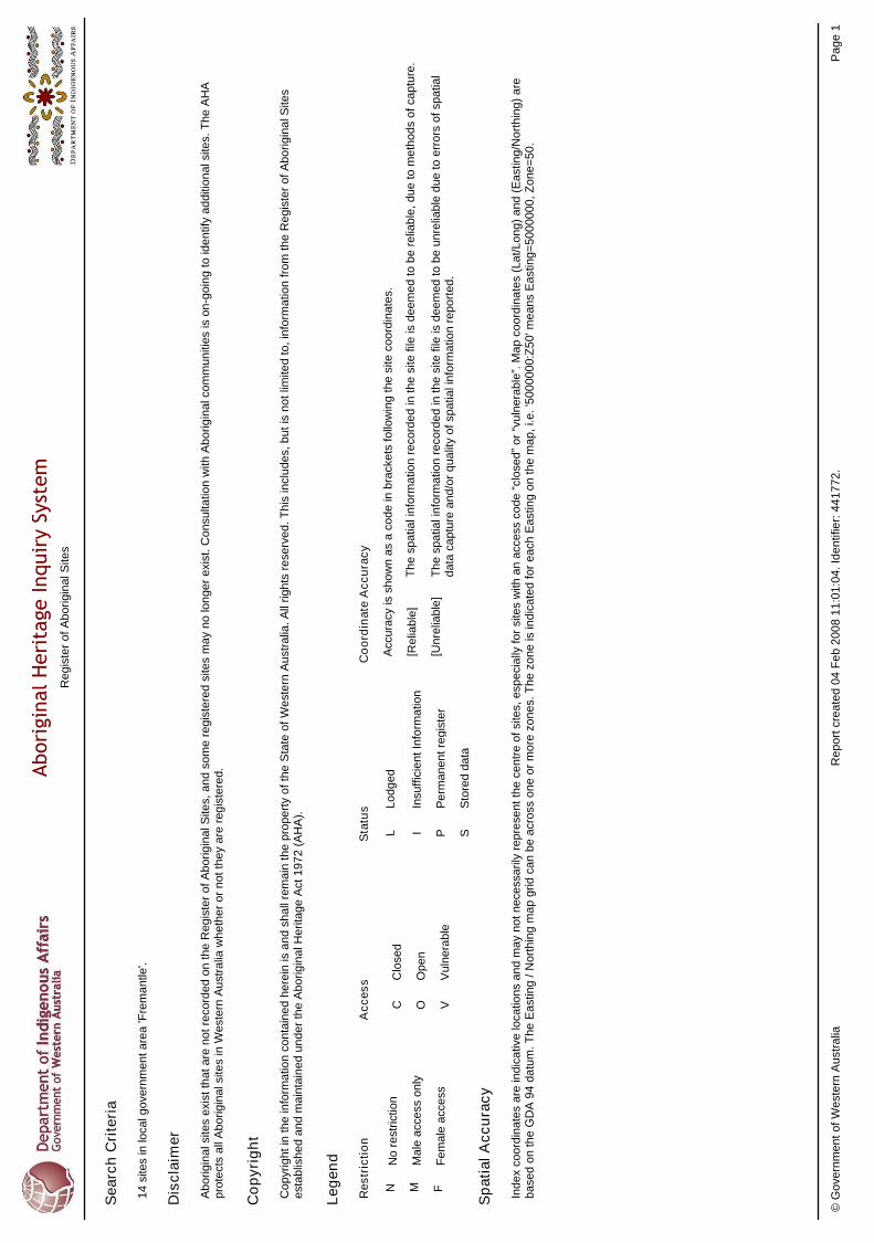
14
site
s in
loca
l go
vern
me
nt
are
a 'F
rem
an
tle'.
Se
arc
h C
rite
ria
N M F
No
re
stri
ctio
n
Ma
le a
cce
ss o
nly
Fe
ma
le a
cce
ss
Le
ge
nd
I S
Insu
ffic
ien
t In
form
atio
n
Pe
rma
ne
nt
reg
iste
r
Sto
red
da
ta
C O V
Clo
sed
Op
en
Vu
lne
rab
le
[Re
liab
le]
[Un
relia
ble
]
Th
e s
pa
tial i
nfo
rma
tion
re
cord
ed
in t
he
site
file
is d
ee
me
d t
o b
e r
elia
ble
, d
ue
to
me
tho
ds
of
cap
ture
.
Th
e s
pa
tial i
nfo
rma
tion
re
cord
ed
in t
he
site
file
is d
ee
me
d t
o b
e u
nre
liab
le d
ue
to
err
ors
of
spa
tial
da
ta c
ap
ture
an
d/o
r q
ua
lity
of
spa
tial i
nfo
rma
tion
re
po
rte
d.
Re
str
icti
on
Sta
tus
Ac
ce
ss
Co
ord
ina
te A
cc
ura
cy
Acc
ura
cy is
sh
ow
n a
s a
co
de
in b
rack
ets
fo
llow
ing
th
e s
ite c
oo
rdin
ate
s.
Dis
cla
ime
r
Ab
ori
gin
al s
ites
exi
st t
ha
t a
re n
ot
reco
rde
d o
n t
he
Re
gis
ter
of
Ab
ori
gin
al S
ites,
an
d s
om
e r
eg
iste
red
site
s m
ay
no
lon
ge
r e
xist
. C
on
sulta
tion
with
Ab
ori
gin
al c
om
mu
niti
es
is o
n-g
oin
g t
o id
en
tify
ad
diti
on
al s
ites.
Th
e A
HA
p
rote
cts
all
Ab
ori
gin
al s
ites
in W
est
ern
Au
stra
lia w
he
the
r o
r n
ot
the
y a
re r
eg
iste
red
.
Ind
ex
coo
rdin
ate
s a
re in
dic
ativ
e lo
catio
ns
an
d m
ay
no
t n
ece
ssa
rily
re
pre
sen
t th
e c
en
tre
of
site
s, e
spe
cia
lly f
or
site
s w
ith a
n a
cce
ss c
od
e “
clo
sed
” o
r “v
uln
era
ble
”. M
ap
co
ord
ina
tes
(La
t/L
on
g)
an
d (
Ea
stin
g/N
ort
hin
g)
are
b
ase
d o
n th
e G
DA
94
da
tum
. T
he
Ea
stin
g /
No
rth
ing
ma
p g
rid
ca
n b
e a
cro
ss o
ne
or
mo
re z
on
es.
Th
e z
on
e is
ind
ica
ted
fo
r e
ach
Ea
stin
g o
n t
he
ma
p,
i.e.
'50
00
00
0:Z
50
' me
an
s E
ast
ing
=5
00
00
00
, Z
on
e=
50
.
Sp
ati
al
Ac
cu
rac
y
Co
py
rig
ht
Co
pyr
igh
t in
th
e in
form
atio
n c
on
tain
ed
he
rein
is a
nd
sh
all
rem
ain
th
e p
rop
ert
y o
f th
e S
tate
of
We
ste
rn A
ust
ralia
. A
ll ri
gh
ts r
ese
rve
d.
Th
is in
clu
de
s, b
ut
is n
ot
limite
d t
o,
info
rma
tion
fro
m t
he
Re
gis
ter
of
Ab
ori
gin
al S
ites
est
ab
lish
ed
an
d m
ain
tain
ed
un
de
r th
e A
bo
rig
ina
l He
rita
ge
Act
19
72
(A
HA
).
LL
od
ge
d
P
Re
gis
ter
of
Ab
ori
gin
al S
ites
Abori
gin
al H
eri
tage Inquir
y Sy
stem
© G
ove
rnm
en
t o
f W
est
ern
Au
stra
liaR
ep
ort
cre
ate
d 0
4 F
eb
20
08
11
:01
:04
. Id
en
tifie
r: 4
41
77
2.
Pa
ge
1
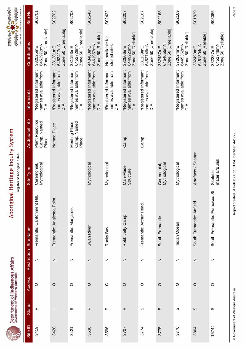
Sit
e I
DS
tatu
sA
cc
es
sR
es
tric
tio
nS
ite
Na
me
Sit
e T
yp
eA
dd
itio
na
l In
foIn
form
an
tsC
oo
rdin
ate
sS
ite
No
.
34
19
S0
27
01
Fre
ma
ntle
: C
an
ton
me
nt H
ill.
OP
Ce
rem
on
ial,
Myt
ho
log
ica
l3
82
52
5m
E
64
53
97
2m
N
Zo
ne
50
[U
nre
liab
le]
Pla
nt R
eso
urc
e,
Ca
mp
, N
am
ed
P
lace
*Re
gis
tere
d I
nfo
rma
nt
na
me
s a
vaila
ble
fro
m
DIA
.
N
34
20
S0
27
02
Fre
ma
ntle
: A
ng
lese
a P
oin
t.O
I3
81
28
1m
E
64
52
41
7m
N
Zo
ne
50
[U
nre
liab
le]
Na
me
d P
lace
*Re
gis
tere
d I
nfo
rma
nt
na
me
s a
vaila
ble
fro
m
DIA
.
N
34
21
S0
27
03
Fre
ma
ntle
: M
an
jare
e.
OS
38
11
93
mE
6
45
27
28
mN
Z
on
e 5
0 [
Un
relia
ble
]
Me
etin
g P
lace
, C
am
p,
Na
me
d
Pla
ce
*Re
gis
tere
d I
nfo
rma
nt
na
me
s a
vaila
ble
fro
m
DIA
.
N
35
36
S0
25
48
Sw
an
Riv
er
OP
Myt
ho
log
ica
l4
43
40
0m
E
64
61
95
7m
N
Zo
ne
50
[R
elia
ble
]
*Re
gis
tere
d I
nfo
rma
nt
na
me
s a
vaila
ble
fro
m
DIA
.
N
35
96
S0
24
22
Ro
cky
Ba
yC
PM
yth
olo
gic
al
No
t a
vaila
ble
fo
r cl
ose
d s
ites
*Re
gis
tere
d I
nfo
rma
nt
na
me
s a
vaila
ble
fro
m
DIA
.
N
37
07
S0
22
07
Ro
bb
Je
tty
Ca
mp
.O
PM
an
-Ma
de
S
tru
ctu
re3
82
50
6m
E
64
49
22
3m
N
Zo
ne
50
[R
elia
ble
]
Ca
mp
*Re
gis
tere
d I
nfo
rma
nt
na
me
s a
vaila
ble
fro
m
DIA
.
N
37
74
S0
21
67
Fre
ma
ntle
: A
rth
ur
He
ad
.O
S3
81
13
9m
E
64
52
74
9m
N
Zo
ne
50
[U
nre
liab
le]
Ca
mp
*Re
gis
tere
d I
nfo
rma
nt
na
me
s a
vaila
ble
fro
m
DIA
.
N
37
75
S0
21
68
So
uth
Fre
ma
ntle
OS
Ce
rem
on
ial,
Myt
ho
log
ica
l3
82
48
7m
E
64
54
05
5m
N
Zo
ne
50
[U
nre
liab
le]
N
37
76
S0
21
69
Ind
ian
Oce
an
OS
Myt
ho
log
ica
l3
72
62
4m
E
64
45
36
2m
N
Zo
ne
50
[R
elia
ble
]
*Re
gis
tere
d I
nfo
rma
nt
na
me
s a
vaila
ble
fro
m
DIA
.
N
38
64
S0
18
29
So
uth
Fre
ma
ntle
: A
ttfie
ldO
SA
rte
fact
s / S
catte
r3
82
49
0m
E
64
51
80
4m
N
Zo
ne
50
[R
elia
ble
]
N
15
74
4S
03
08
5S
ou
th F
rem
an
tle: F
ran
cisc
o S
tO
SS
kele
tal
ma
teri
al/B
uri
al
38
23
87
mE
6
45
17
48
mN
Z
on
e 5
0 [
Re
liab
le]
N
Re
gis
ter
of
Ab
ori
gin
al S
ites
Abori
gin
al H
eri
tage Inquir
y Sy
stem
© G
ove
rnm
en
t o
f W
est
ern
Au
stra
liaR
ep
ort
cre
ate
d 0
4 F
eb
20
08
11
:01
:04
. Id
en
tifie
r: 4
41
77
2.
Pa
ge
2
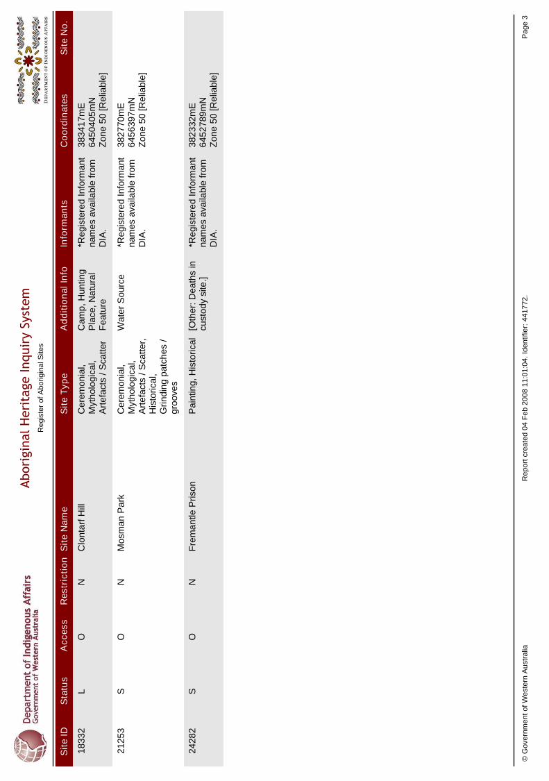
Sit
e I
DS
tatu
sA
cc
es
sR
es
tric
tio
nS
ite
Na
me
Sit
e T
yp
eA
dd
itio
na
l In
foIn
form
an
tsC
oo
rdin
ate
sS
ite
No
.
18
33
2C
lon
tarf
Hill
OL
Ce
rem
on
ial,
Myt
ho
log
ica
l, A
rte
fact
s / S
catte
r
38
34
17
mE
6
45
04
05
mN
Z
on
e 5
0 [
Re
liab
le]
Ca
mp
, H
un
ting
P
lace
, N
atu
ral
Fe
atu
re
*Re
gis
tere
d I
nfo
rma
nt
na
me
s a
vaila
ble
fro
m
DIA
.
N
21
25
3M
osm
an
Pa
rkO
SC
ere
mo
nia
l, M
yth
olo
gic
al,
Art
efa
cts
/ S
catte
r,
His
tori
cal,
Gri
nd
ing
pa
tch
es
/ g
roo
ves
38
27
70
mE
6
45
63
97
mN
Z
on
e 5
0 [
Re
liab
le]
Wa
ter
So
urc
e*R
eg
iste
red
In
form
an
t n
am
es
ava
ilab
le f
rom
D
IA.
N
24
28
2F
rem
an
tle P
riso
nO
SP
ain
ting
, H
isto
rica
l3
82
33
2m
E
64
52
78
9m
N
Zo
ne
50
[R
elia
ble
]
[Oth
er:
De
ath
s in
cu
sto
dy
site
.]*R
eg
iste
red
In
form
an
t n
am
es
ava
ilab
le f
rom
D
IA.
N
Re
gis
ter
of
Ab
ori
gin
al S
ites
Abori
gin
al H
eri
tage Inquir
y Sy
stem
© G
ove
rnm
en
t o
f W
est
ern
Au
stra
liaR
ep
ort
cre
ate
d 0
4 F
eb
20
08
11
:01
:04
. Id
en
tifie
r: 4
41
77
2.
Pa
ge
3

Re
gis
ter
of
Ab
ori
gin
al S
ites
Abori
gin
al H
eri
tage Inquir
y Sy
stem
Le
ge
nd
To
wn
Hig
hlig
hte
d A
rea
Ma
p A
rea
Se
arc
h A
rea
Co
pyr
igh
t fo
r b
ase
ma
p
info
rma
tion
sh
all
at
all
time
s re
ma
in t
he
pro
pe
rty
of
the
C
om
mo
nw
ea
lth o
f A
ust
ralia
, G
eo
scie
nce
Au
stra
lia -
N
atio
na
l Ma
pp
ing
Div
isio
n.
All
rig
hts
re
serv
ed
.
Co
pyr
igh
t fo
r N
ativ
e T
itle
La
nd
C
laim
, L
oca
l Go
vern
me
nt
Au
tho
rity
, M
inin
g T
en
em
en
t b
ou
nd
ari
es
sha
ll a
t a
ll tim
es
rem
ain
th
e p
rop
ert
y o
f th
e
Sta
te o
f W
est
ern
Au
stra
lia,
All
rig
hts
re
serv
ed
.
Fo
r fu
rth
er
imp
ort
an
t in
form
atio
n o
n u
sin
g t
his
in
form
atio
n p
lea
se s
ee
th
e
De
pa
rtm
en
t o
f In
dig
en
ou
s A
ffa
irs’
Te
rms
of
Use
st
ate
me
nt
at
htt
p:/
/ww
w.d
ia.w
a.g
ov.
au
/Te
rms-
Of-
Use
/
© G
ove
rnm
en
t o
f W
est
ern
Au
stra
liaR
ep
ort
cre
ate
d 0
4 F
eb
20
08
11
:01
:04
. Id
en
tifie
r: 4
41
77
2.
Pa
ge
4
A DESKTOP ETHNOGRAPHIC ABORIGINAL HERITAGE SURVEY OF THE HIGH STREET UPGRADE BETWEEN STIRLING HIGHWAY AND CARRINGTON STREET, FREMANTLE, WESTERN AUSTRALIA.
_______________________________________________________________________________________________________
22
APPENDIX 2. MAP OF THE PROJECT AREA
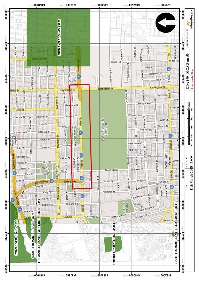
1:1
5,0
00
FR
EM
AN
TL
E.
Sit
eID
:- 3
72
6
SW
AN
RIV
ER
S
ite
ID:-
35
36
FR
EM
AN
TL
E:
CA
NT
ON
ME
NT
HIL
L.
Sit
eID
:- 3
41
9
Fre
ma
ntl
e P
ris
on
S
ite
ID:-
24
28
2
SO
UT
H F
RE
MA
NT
LE
S
ite
ID:-
37
75
SO
UT
H F
RE
MA
NT
LE
: A
TT
FIE
LD
S
ite
ID:-
38
64
38
20
00.000000
38
20
00.000000
38
25
00.000000
38
25
00.000000
38
30
00.000000
38
30
00.000000
38
35
00.000000
38
35
00.000000
38
40
00.000000
38
40
00.000000
38
45
00.000000
38
45
00.000000
38
50
00.000000
38
50
00.000000
38
55
00.000000
38
55
00.000000
38
60
00.000000
38
60
00.000000
6452000.000000
6452000.000000
6452500.000000
6452500.000000
6453000.000000
6453000.000000
6453500.000000
6453500.000000
6454000.000000
6454000.000000
11th
Marc
h 2
00
8
DA
TE
SC
AL
E -
A4
Ma
pp
ing
pro
vid
ed
by
GD
A 1
994 M
GA
Zon
e 50
0140
280
420
560
70
Mete
rs
1 c
m e
qu
als
15
0 m
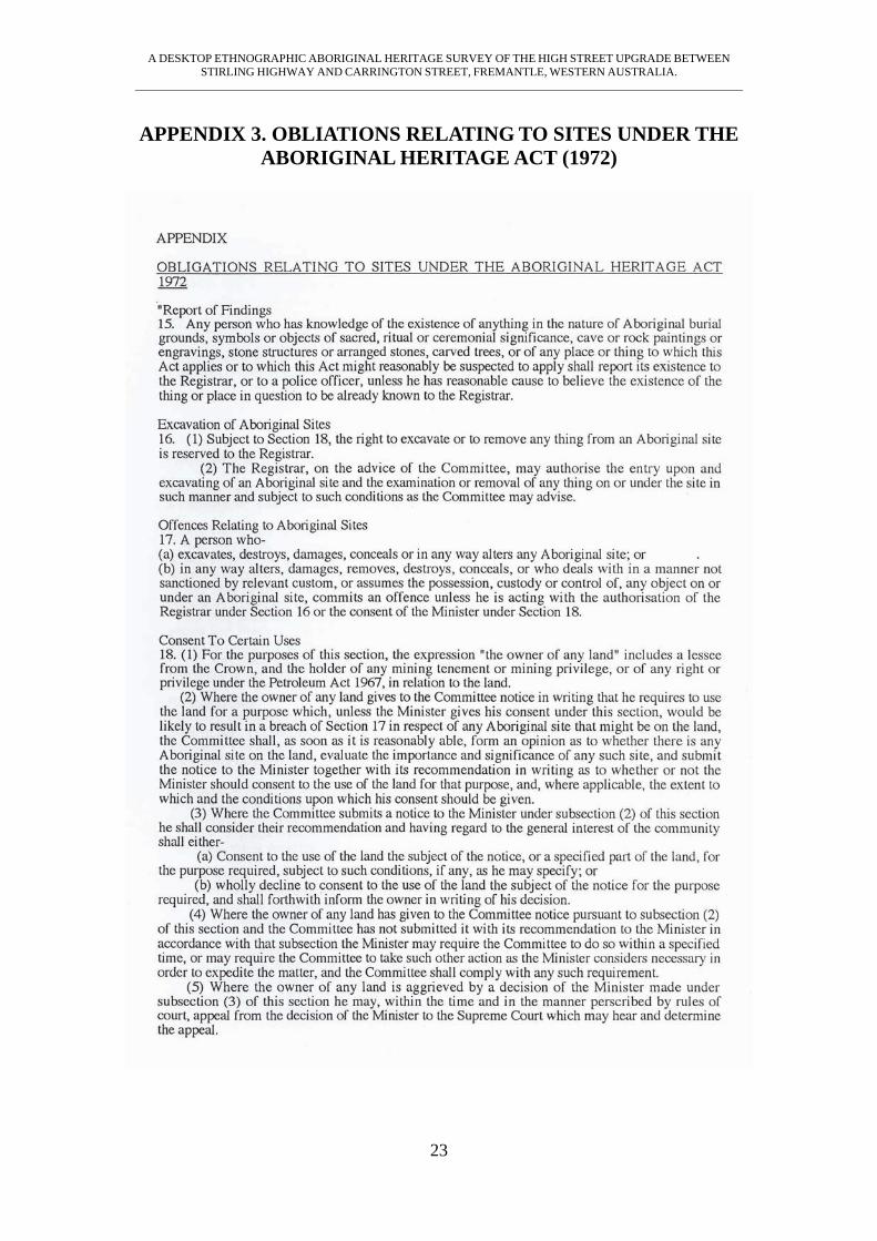
A DESKTOP ETHNOGRAPHIC ABORIGINAL HERITAGE SURVEY OF THE HIGH STREET UPGRADE BETWEEN STIRLING HIGHWAY AND CARRINGTON STREET, FREMANTLE, WESTERN AUSTRALIA.
_______________________________________________________________________________________________________
23
APPENDIX 3. OBLIATIONS RELATING TO SITES UNDER THE ABORIGINAL HERITAGE ACT (1972)
A DESKTOP ETHNOGRAPHIC ABORIGINAL HERITAGE SURVEY OF THE HIGH STREET UPGRADE BETWEEN STIRLING HIGHWAY AND CARRINGTON STREET, FREMANTLE, WESTERN AUSTRALIA.
_______________________________________________________________________________________________________
24

A DESKTOP ETHNOGRAPHIC ABORIGINAL HERITAGE SURVEY OF THE HIGH STREET UPGRADE BETWEEN STIRLING HIGHWAY AND CARRINGTON STREET, FREMANTLE, WESTERN AUSTRALIA.
_______________________________________________________________________________________________________
25
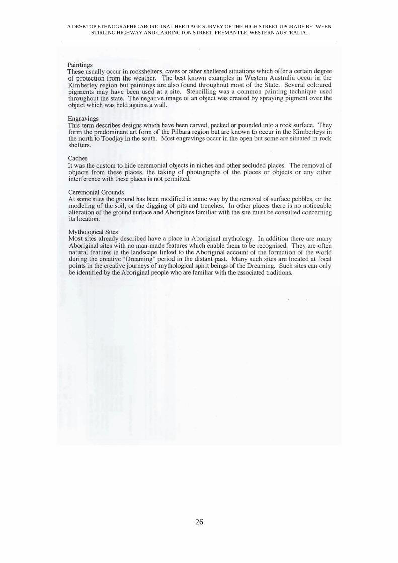
A DESKTOP ETHNOGRAPHIC ABORIGINAL HERITAGE SURVEY OF THE HIGH STREET UPGRADE BETWEEN STIRLING HIGHWAY AND CARRINGTON STREET, FREMANTLE, WESTERN AUSTRALIA.
_______________________________________________________________________________________________________
26