Embed Size (px)
Citation preview

1 of 4 3/29/2012
DEPARTMENT OF PLANNING AND DEVELOPMENT
HILLCREST DESIGN OVERLAY DISTRICT RESIDENTIAL
HANDOUT FOR BUILDING PERMIT APPLICATIONS: APPLICANT SUBMITTALS CHECKLIST: Survey requirements for additions or new structures. Survey must show:
• Additional setback information is required. On structures located in mid-block, dimensions shall be noted on adjoining structure’s front setbacks with partial buildings graphically shown. On structures located on the corner of blocks, dimensions shall be noted on adjoining structure’s street side setbacks with partial buildings graphically shown.
• Finished topographical lines for entirety of lots.
• Proposed outlines of structure(s).
• Average grade plane elevation noted.
• Average grade plane graphically shown as measured six feet from footprint or property line (whichever is less).
• Note highest existing or proposed ridgeline elevation.
• Elevations of proposed structure or additions, showing exposed foundation walls. INTERPRETATION OF ORDINANCE: 1) When calculating Floor Area Ratio (FAR):
a) Do not include unenclosed porches. b) Do not include carports that are open on at least two sides. c) Include attached garages. d) You must count attached unfinished spaces, such as storage spaces and above ground basements at 50%.
If there is an inside stairway to an attic or basement, that counts as storage space. 2) How to measure front yard setback on existing or proposed structures: The measurement is from 12” above
grade on the closest vertical surface measured to the front property line. 12” up on the building may be the second step, a porch, or a wall of house, etc.; whichever point is closest to the street.
3) Average front yard setback is calculated by averaging the two adjoining structure’s setbacks for those structures
in mid-block. 10% of that average is the range in which the front setback of the proposed structure or front addition shall fall.
4) Front yard setbacks: If adjoining structures are encroaching in the 15’ front setback or the average is
encroaching in the 15’ front setback, the proposed structure or front addition must be built at the 15’ front setback line.
5) If the house is on a corner lot, the following applies:
a) The front setback shall be within 10% variation of the adjoining principal structure and the side yard setback shall be within 10% variation of the adjoining principal structure.
b) Additions to the rear of the structure shall conform to the 10% variation rule for side yard setbacks. 6) An addition to the side of the structure on an interior lot line that does not extend in front of the main wall of the
house shall not be subject to the front yard setback 10% variation rule. ADMINISTRATION: 1) If the proposed improvement meets all Hillcrest DOD requirements but still needs a Board of Adjustment
hearing, it goes to the Board of Adjustment. This applies only to fencing and possibly signage. 2) Permits may not be issued on the same day that they are received. Allow 1-2 days for processing and approval.
The zoning desk will collect all information and fill out the checklist when that application is submitted. 3) Building permits for interior work only, routine repairs and maintenance shall not be subject to the Hillcrest DOD.

2 of 4 3/29/2012
Examples Of Additional Information To Be Included On Surveys For The Hillcrest DOD.
Actual elevation numbers will vary.
Examples Of Additional Information To Be Included On Surveys For The Hillcrest DOD.
Actual elevation numbers will vary.

3 of 4 3/29/2012
How to calculate the Grade Plane Elevation for the Hillcrest DOD.

4 of 4 3/29/2012
DEPARTMENT OF PLANNING AND DEVELOPMENT
HILLCREST DESIGN OVERLAY DISTRICT RESIDENTIAL
ZONING COMPLIANCE CERTIFICATE ADDRESS: ______________________________________________________
LEGAL DESCRIPTION: _____________________________________________________________________________
________________________________________________________________________________________________
ZONING CLASSIFICATION: ___________________________________________ FLOODPLAIN DISTRICT: YES NO
PROPOSED USE: ____________________________________ EASEMENT CLEARANCE: APPROVED OR DENIED
REG CHART BLDG HEIGHT
FRONT SETBACK
REAR SETBACK
SIDE SETBACK
MSP PLATTED BLDG LINE
MIN SEP
PRINCIPAL STRUCTURE
39 to
PROPOSED
ACCESSORY STRUCTURE
39 60
PROPOSED
Source?
NUMBER OF STORIES OF STRUCTURE: (1, 2 or 2.5) ____________ __________
FAR SCALE MULTIPLIERS (<8,000 sf lot - .37, .50, .55) (>8,000 - .37, .50, .50) ____________ % __________
LOT SIZE: X___________ SF __________
MAX BUILDING SF: ____________ SF __________
PROPOSED PRINCIPAL BUILDING SF FROM PLAN: ____________ SF __________
MAX LOT COVERAGE: (<4,500 sf lot - .60) (>4,500 sf lot - .50) ____________ SF __________
PROPOSED LOT COVERAGE: (all structures under roof – footprint only) ____________ SF __________
FRONT YARD SETBACKS: (10% variation of average depth of two
adjacent houses) (shall show side houses on survey) ____________ FEET __________
REAR YARD SETBACK COVERAGE (MAX 40% for accessory structures): ____________ % __________
GRADE PLANE ELEVATION: (shall show finished topo on plan Average
finished ground level 6’ out from building) ____________ FEET __________
BUILDING HEIGHT AS MEASURED FROM GRADE PLANE:
(measure from grade plane elevation to highest ridge of roof) ____________ FEET __________
CIRCLE THIS LINE IF INTERIOR REMODEL ONLY: _____ APPLICATION IS DENIED (See discrepancies indicated in red above.) _____ APPLICATION IS APPROVED. ZONING OFFICER: __________________________________ DOD INITIALS :____________ DATE: __________ I hereby certify that the data submitted on or with the application is true and correct. Also, I have read and I understand the Hillcrest Design Overlay District. Any deviation from information contained hereon unless approved by the Zoning Official will render this permit null and void. ______________________________________________ ______________________ _________________ Signature of Contractor, Owner or Agent Date Phone

"A"
MONR
OE
PINE
WOOD
ROW
MARKHAM
OZARKMARTINEDGERSTOUNE
LOOKOUTKAVANAUGH
"L"
FILLM
ORE
"H"
GRAN
T
LEE
FILLM
ORE
CANTRELL
UNIVE
RSITY
CANTRELL
Hillcrest DOD Boundary The data contained herein was compiled from various sources
for the sole use and benefit of the Pulaski Area Geographic Information System (PAGIS) and the public agencies it serves.
Any use of the data by anyone other than PAGIS is at the sole risk of the user; and by acceptance of this data, the
user does hereby hold PAGIS harmless and without liability from any claims, costs, or damages of any nature against
PAGIS, including cost of defense arising from improper use of the data, or use by another party.
Acceptance or use of this data is done without any expressed or implied warranties.
The geographic data herein was taken from March 1990 Photography
0 1,000 2,000500Feet

ccrirG 5244ilti
Rrdin CciRrdof P4TtE39iv
PllLASiOllvT11Rt11TICSNTCtR
seesU
1 ORDINANCEN020223
3 AN ORDINANCE TO REPEAL CHAPTER 36 ARTICLE V DIVISION 13
4 SECTION 3643410 THROUGH SECTION 3643416 KNOWN AS
5 HILLCREST DESIGN OVERLAY DISTRICT TO ADOPT NEW
6 LANGUAGE FOR CHAPTER 36 ARTICLE V DIVISION 8 SECTION
7 3643410THROUGH SECTION 3643416TO BE KNOWN AS THE
8 HILLCREST DESIGN OVERLAY DISTRICT AND FOR OTHER
9 PURPOSES
10
11 WHEREAS as the Planning Staff the Hillcrest Residents Association and the Hillcrest Merchants
12 Association has completed a through review concerning all aspects of the Design Overlay District and
13 WHEREAS as the Little RockPlanning Commission believes it appropriate to amend the plan
14 NOW THEREFORE BE IT ORDAINED BY THE BOARD OF DIRECTORS OF THE CITY
15 OF LITTLE ROCK ARKANSAS
16 Section 1 That Chapter 36 Article V Division 13 Section 3643410through section 3643416
17 inclusive known as Design Guidelines be repealed
18 Section 2 That the following be adopted as Chapter 36 Article V Division 13 Section 3643410
19 through section 3643416to be known as HILLCREST DESIGN OVERLAY DISTRICT
20 DIVISION 13 HILLCREST DESIGN OVERLAY DISTRICT
21 Sec 3643410Purpose and intent
22 The purpose of a Hillcrest design overlay district district is to help maintain the
23 built enviromllent in a neighborhood that is rich in history and architectural character and
24 consists of both a vital residential area and a thriving commercial sector In order to
25 preserve and enhance those qualities compatible design and scale of buildings parking
26 areas signage landscapvlg streetscapes and street furnishings are required such that the
27 friendly pedestrianoriented smalltownnature of the neighborhood is continued
28 Through additional guidelines for buildings the district intends to prevent incompatible
29 and poorly planned projects from having a negative impact on Hillcrestsunique
30 character and its living and working environment Such incompatible construction has
31 the potential to destroy the very attributes that have attracted people to the neighborhoodd t
32 since its beginning as Little Rocksfirst suburb in the 1890s and more recently dunn
33 its resurgence since the 1960sa F
v
is Y
a
Page 1 of 10 R 4
4j wk4V
y 9ri 7 yp3IIyiqehe5d45

1
2
3
4
5
6
7
8
9
10
11
12
13
14
15
16
17
18
19
20
21
22
23
24
25
26
27
28
29
30
31
32
33
34
Sec 3643411Definitions
Floor area ratio FAR The total area of all enclosed spaces on all floors of the
principal structure as measured to the outside surfaces ofthe exterior walls and including
halls stairways elevator shafts and attached garages divided by the area ofthe lot
Attached unfinished spaces such as storage areas floored attics and aboveground
basements shall be included as part of the permitted floor area at fifty 50 percent of the
measured area
Crawlspaces or similar spaces that must be accessed from outside the main structure
unenclosed porches decks and attached carports that are open on at least two sides are
excluded from the permitted floor area
Grade plane A reference plane representing the average of finished groundlevel
adjoining the building at exterior walls The reference plane shall be established by the
lowest points withal the area between the building and the lot line or where the lot line is
more than six 6 feet from the building between the building and a point six 6 feet
from the building A minimum of four 4 points each from a different side of the
building shall be used in this calculation
Lot coverage The area of a lot covered by a building or buildings expressed as a
percentage of the total lot area All buildings or structures that have a roof are counted
toward the total Decks driveways patios arbors trellises and other structures that do
not have a roof are not counted toward the total
Sec 3643412Application ofthe regulations
A The regulations of this district shall be in addition to and shall overlay all other
zoning districts and other ordinance requirements regulating the development of land so
that any parcel of land lying in the overlay district shall also lie within one 1 or more of
the other underlying zoning districts Therefore all property within this overlay district
shall have requirements ofboth the underlying and overlay zoning districts in addition to
any other provisions regulating the development of land hi case ofconflicting standards
between this article and other city ordinances the overlay requirements shall control
B These regulations shall apply to new development and redevelopment exceeding
fifty 50 percent of the structurescurrent replacement value or expansion of existing
development These regulations shall apply to new development expansion of existing
development when a permit is requested for exterior improvements on buildings and
private improvements located in the public rightofway Private improvements in the
public rightofway may include but not limited to awnings benches and flagpoles
Page 2 of 10

1 Routine repairs maintenance and interior alterations shall not require compliance with
2 this section
3 C Uses structures or lots that existed on the effective date of this ordinance July
4 17 2007 which do not conform to the standards and guidelines established in this
5 division shall be treated as nonconforming according to the provisions of article III
6 Nonconforming status shall not apply to construction of improvements in the public7 rightofway required by the city redevelopment or expansion of the existing8 development9 D The following guidelines shall apply to both residential and nonresidential types
10 ofstructures In the case ofmultiuse structures the applicant shall conform to Sec 36
11 43415 the MultiFamilyNonResidential Developments12 E Churches and schools regardless ofunderlying zoning shall conform to Sec 36
13 43415MultiFamily Non Residential Developments All other properties which
14 require Conditional Use Permits and Special Use Permits on residentially zoned land
15 shall conform to Sec 3643414 Single Family and Two Family Development section
16 Sec 3643413Overlay boundaries
17 The district shall include all parcels within the area bounded as follows less that area
18 within the Midtown DOD chapter 36 article V division 10
19 Starting at the southwest corner o the Arkansas School for the Blind with
20 Markham thence west along Markham to University Avenue thence north along
21 University Avenue to H Street thence east along H Street to Fillmore thence
22 north along Fillmore Street to L Street thence east along LStreet to Kavanaugh
23 Boulevard thence south along Kavanaugh Boulevard to North Lookout Street thence
24 east along North Lookout southernboundary ofAllsop Park north thence east and
25 south along the north and west boundary of Doyle Place Addition to Allsop Park
26 south thence south and west alon said boundary to Cedar Hill Road thence
27 southwest along Cedar Hill Road to point approximately two hundred fifty 250
28 feet west of Cedar Hill Circle thence south approximately two hundred 200 feet
29 thence north east parallel to Oakwood IiRoad approximately seven hmldred 700 feet
30 thence south to a point two hundred 2100 feet north ofIStreet thence east parallel
31 toIStreet and Edgerstoune Laneaplroximately one thousand six hundred1600
32 feet thence south approximately two hundred 200 feet to Ozark Point Water
33 Treatment Plant thence east south and west along the boundary of the Ozark Point
34 Water Treatment Plant to Arkansas School for the Blind thence south along the
Page 3 of 10

1 western bomdary of the Arkansas School for the Blind to Markham the point of
2 beginning3 Sec 3643414Single Family and Two Family Developments4 The residential regulations shall apply to Single Family and Two Family
5 Developments R2 R3 and R4residential zoned land within the district boundaries
6 Although the overlay district does not regulate the style and character of Hillcrest
7
8
9
10
11
12
13
14
15
16
17
18
19
20
21
22
23
24
25
26
27
28
29
30
31
32
33
34
housing new construction and additions should be respectful of the prevailing styles of
the neighborhood The compatible design of housing contributes to the richness of the
history and architectural character ofHillcrest
A Scale
Floortoarea ratio is abbreviated as FAR
Lotsizes of less than eight thousand 8 000 squarefeetFor residential structures with one 1 floor the FAR shall be037
For residential structures with two 2 floors the FAR shall be050
For residential structures with two 2 or more floorsiebuiltoutattics the FAR shall
be 55
Lot sizes of eight thousand 8 000 square feet or more
For residential structures with one 1 floor the FAR shall be037
For residential structures with more than one 1 floor the FAR shall be050
The purchase ofan adjoining lot shall not allow a proportionate increase in the size of the
building in all cases For the purposes ofcomputing the FAR lot sizes of more than ten
thousand 10000 square feet shall use a maximum lot size in the calculations of ten
thousand 10000 square feet Any lot of record or any combination of lots creating a
zoning lot of record exceeding ten thousand 10000 square feet in existence at the time
ofthe adoption of this section shall have an FAR as described for lots exceeding eight
thousand8000 square feet
B Mass Maximum lot coverage for all structures under roof shall not exceed fifty
50 percent For lots of four thousand five hundred4500 SF or less maximum lot
coverage for all structures under roof shall not exceed sixty 60 percent
C Setbacks All setbacks shall be as required for the zoning district except as
follows
1 The minimum front yard setback for new principal strictures or additions to
principal structures in the R2R3 and R4zoning districts shall be fifteen 15
feet in all instances
Page 4 of 10
1 2 Front yard and side yard setbacks on existing and proposed buildings shall be
2 measured from twelve 12 inches above grade on the closest vertical surface
3 measured to the property line
4 3 Front yard setbacks for structures on interior lots The front yard setback for the
5 principal structure shall be aligned with the average of the current setbacks of the
6 adjoining residential structures within ten 10 percent variance but no structure
7 may be within the minimum fifteen 15 foot front setback as established in this
8 section
9 4 If adjoviing structures or the average of the adjoining structures is
10 encroaching into the minimum fifteen 15 foot front yard setback as set forth in
11 this section or the minimum street side yard setback as stated elsewhere in this
12 Chapter the building shall be built to the minimum front yard andor the street
13 side yard setback line
14 5 Additions to the side of a principal structure on an interior lot line shall not be
15 subject to the front yard setback 10 variance rule if the addition does not extend
16 in front of the main wall ofthe existing structure towards the front property line
17 6 Front and street side yard setbacks for structures on corner lots The front yard
18 setback shall be within 10 of the adjoining residential principal structure and
19 the street side yard setback shall be within 10 of the adjoining residential
20 principal structure but no structures shall be built within the minimum front or
21 side yard setbacks
22 7 Additions to the rear of the principal structure on a corner lot shall not be subject
23 to the side yard setback 10 variation rule if the addition does not extend in front
24 of the main wall of the structure towards the street side property line
25 8 When determining front or side yard setbacks on a structure that is oriented
26 differently than all other structures on the block face the front yard setback shall
27 be fifteen 15 feet and the side yard setback shall be 10of the lot width not to
2 exceed eight 8 feet
29 9 Accessory Buildings setbacks and separations shall be as permitted in 36156
30 Height and area exceptions
31 D Accessory Building Coverage Accessory building coverage within the twenty
32 fivefoot setback from the rear property line shall be no more than forty 40 percent of
33 the area in that section
Page 5 of 10

1
2
3
4
5
6
7
8
9
10
11
12
13
14
15
16
17
18
19
20
21
22
23
24
25
26
27
28
29
30
31
32
E Building height and ridgeline elevations Maximum building height shall be
thirtynine39 feet measured from the grade plane to the ridgelineofthe highest roof
surface In addition new buildings and additions shall be constructed to an elevation that
is within one story of the adjacent residential structures
Sec 3643415MultiFamily andNonresidential DevelopmentsThe MultiFamily and Nonresidential Developments regulations shall apply to all
zoning districts except R2 R3 and R4within the district and shall apply to all
churches and schools regardless ofunderlying zoning within the district
A Building form New a11d renovated buildings more than fifty 50 percent
exterior surface area altered shall be compatible with existing scale setbacks and mass
ofthe buildings in the immediate area eg along Kavanaugh Boulevard most buildings
have minimum setbacks from the street whereas along Beechwood the former residences
have setbacks with yards
1 Facades Streetlevel facades shall reflect the same building materials as existing
commercial buildings in the oneblock area adjacent to and across from the
location Predominant exterior building materials may be any standard material
except corrugated or ribbed materials smoothfaced concrete block tiltup
concrete panels or prefabricated steel panels2 Setbacks Setbacks from street and alley shall meet current code requirements
except setbacks may align with surrounding structures
Frontyard setbacks on Kavanaugh Boulevard between Rose Street and L
Street shall not exceed ten 10 feet A minimum of fifty 50 percent ofthe front
facade must be constructed along this line Front yard and side yard setback on
existing and proposed buildings shallbe measured from twelve 12 inches above
grade on the closest vertical surface measured to the appropriate property line
3 Height Maximum building height shall be thirtynine 39 feet measured from
the grade plane to the ridgeline of the highest roof surface or parapet wall
4 Buildingform
a Wall projections or recesses a minimum of three 3 feet depth and a
minimum of twenty 20 contiguous feet not to extend over twenty 20
percent of the facade shall be required Arcades display windows entry
areas or awnings shall exist along at least sixty 60 percent of the facade
Page 6 of 10

1 b Buildings shall maintain a distinction between upper and lower levels any
2 elevation greater than eighteen feet in height shall contain an architectural
3 treatment which visually divides the structure into stories
4 c Roof lines shall be varied with a change in height every one hundred 1005 linear feet in building length Parapets mansard roofs gable roofs high6 roofs shall be used to conceal flat roofs and roof top equipment7 B Parking8 1 Standardparking requirements Parking requirements within the district shall be
9 fifty 50 percent of that required by Article VIII The maximum parkilig10 allowed for this district shall be the minimum standard established in Article
11 VIII MultiFamily developments or mixeduse developments that contain
12 residential units must provide the minimum number ofparking spaces as required13 in Sec 36502 for those residential units All other parking for the mixeduse
14 facility may develop at the requirements stated in this division
15 2 Offsite parking Whereonstreet parking is allowed it shall be credited toward
16 the parking requirements at a rate of one 1 space per ten 10 linear feet of
17 street frontage Parking spaces within a common parking facility may be counted
18 toward the parking requirements of any development The total number of
19 parking spaces within the common parking facility shall not be less than the sum
2fl ofrequirements for the various individual uses utilizing the facility21 3 Parking facilities Surface parking shall be limited to the side and rear of
22 structures No parking shall be allowed in the frontyard setback Surface
23 parking is to be located behind or adjacent to a structure never between the
24 building and any abutting street
25 Any parking structure shall be required to have active uses on the street level
26 other than parking such as quiet office or neighborhood retail uses
27 C Utilities andservices All new developments are required to place utilities and
28 cabled services in subterranean locations from the pole to the structure
29 D Signage Permitted signs shall be as in section 36553 signs permitted in
30 institutional and office zones On the street level the maximum area of Signage may be
31 doubled if at least fifty 50 percent of the streetlevel office and retail space has direct
32 access to the street
33 The highest point on any commercial sign attached to the building shall not exceed
34 the corresponding buildingsheight
Page 7 of 10
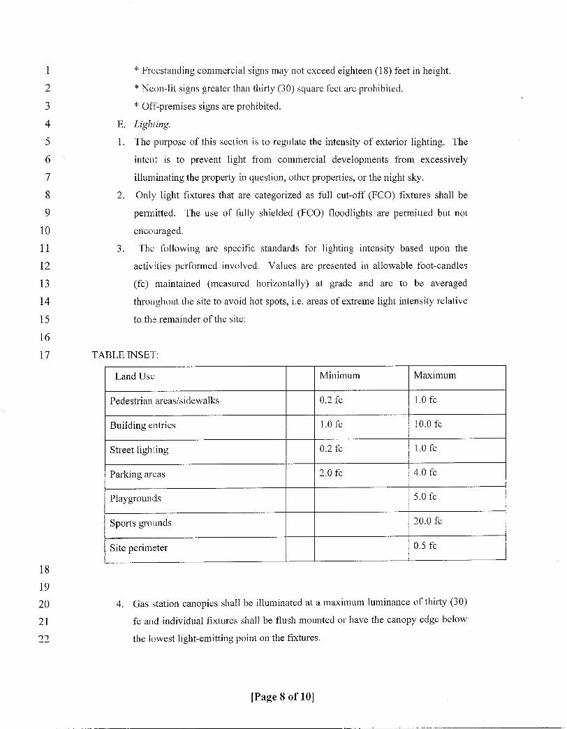
1 Freestanding commercial signs may not exceed eighteen 18 feet in height2 Neonlit signs greater than thirty 30 square feet are prohibited
3 Offpremises signs are prohibited4 E Lighting
5 1 The purpose of this section is to regulate the intensity of exterior lighting The
6 intent is to prevent light from commercial developments from excessively7 illuminating the property in question other properties or the night sky8 2 Only light fixtures that are categorized as full cutoffFCO fixtures shall be
9 permitted The use of frilly shielded FCO floodlights are permitted but not
10 encouraged11 3 The following are specific standards for lighting intensity based upon the
12 activities performed involved Values are presented u1 allowable footcandles
13 fc maintained measured horizontally at grade and are to be averaged
14 throughout the site to avoid hot spotsie areas ofextreme light intensity relative
15 to the remainder ofthe site
16
17 TABLE INSET
Land Use Minimum Maximum
Pedestrian areassidewalks 02fc 10fc
Building entries 10fc 100fc
Street lighting 02fc 10fc
Parking areas 20fc 40fc
Playgrounds 50fc
Sports grounds 200fc
Site perimeter 05fc
18
19
20 4 Gas station canopies shall be illuminated at a maximum luminance of thirty 30
21 fc and individual fixtures shall be flush mounted or have the canopy edge below
22 the lowest lightemitting point on the fixtures
Page 8 of 10

1 5 Up lighting may be used to illuminate a building landscaping element or
2 architectural feature provided the lighting design has a maximum luminance of
3 twelve 12 fc measured in a vertical plane Down lighting is preferred4 6 Alighting plan shall be submitted for staff review and approval prior to issuance
5 ofbuilding permits The plan shall contain the following information
6 aiarea lighting plan drawn to scale indicatilig all structures parking lots
7 building entrances vehicular and pedestrian traffic areas vegetation that may
8 interfere with lighting and adjacent land uses that may be adversely
9 impacted by the lighting The plan shall contain a layout of all proposed
10 fixtures by location orientation aiming direction mounting height and type
11 b The submission shall include in addition to proposed area lighting all other
12 exterior lighting eg architectural building entrance landscape flagpole
13 sign etc
14 c A ten 10 foot luminance grid pouitbypoint of maintained footcandles
15 overlaid on the site plan plotted out to 00footcandles which demonstrates
16 compliance with light intensity standards
17 Sec 3643416Exceptions
18 Property if for any reason that cannot be developed without violating the standards
19 of this article shall be reviewed through the planned zoning district PZD section of the
20 zoning ordinance with the intent to devise a workable development plan which is
21 consistent with the purpose and intent ofthe overlay standards
22 Secs36434173643424Reserved
23 Section 3 That the ordinance shall take effect and be in full force from and after its passage and
24 approval25 Section 4 Seveiability h1 the event any portion of this ordinance is declared or adjudged to be
26 invalid or unconstitutional such declaration or adjudication shall not affect the remaining portions of this
27 ordinance which shall remain in full force and effect as if the portion so declared or adjudged u7valid or
28 unconstitutional were not originally a part of this ordinance
29 Section 5 Repealer All ordinance and resolutions and parts thereof which are in conflict with any
30 provision ofthis ordinance are hereby repealed to the extent ofsuch conflict
31
32 PASSED March 2 2010
33
34
Page 9 of 10

1 ATTEST
2
34 n ngl A ing City Clerk
5 APPR E LEGAL FORM
6
8 Thomas M Carpenter City t rney
9
10
11
12
13
14
15 l
16
17
18
19
20
21
22
23
24
25
26
27
28
29
3 0
31
32
33
34
3 5 1
APPROVED
jjJpCMark Stodola Mayor
Page 10 of 10