Embed Size (px)
Citation preview
DETAILED ENVIRONMENT IMPACT ASSESSMENT FOR THE CONSTRUCTION OF PAYA PEDA DAM, BESUT, TERENGGANU
EXECUTIVE SUMMARY ES - 1
EXECUTIVE SUMMARY
1.0 INTRODUCTION
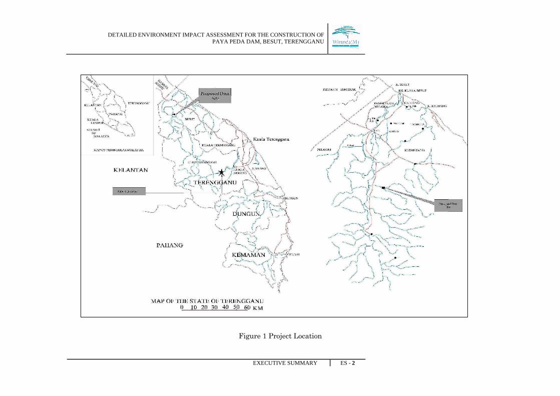
The Ministry of Agriculture and Agro-Based Industry (MOA) intends to construct a dam
in Besut, Terengganu for irrigation, reducing flood damage in the Besut valley and
augmenting supplies for town water supply needs within the catchment of Sg. Besut.
The dam will be called the Paya Peda Dam. The reservoir is estimated to be 1,212 ha
from the total catchment of 7, 700 ha. A dam project of this magnitude will require a
Detailed Environmental Impact Assessment study. In addition, there are also socio-
economic impacts and resettlement issues that need to be addressed. The dam
construction will also require an Environmental Management Plan and an Emergency
Response Plan.
DETAILED ENVIRONMENT IMPACT ASSESSMENT FOR THE CONSTRUCTION OF PAYA PEDA DAM, BESUT, TERENGGANU
EXECUTIVE SUMMARY ES - 2
Figure 1 Project Location
DETAILED ENVIRONMENT IMPACT ASSESSMENT FOR THE CONSTRUCTION OF PAYA PEDA DAM, BESUT, TERENGGANU
EXECUTIVE SUMMARY ES - 3
2.0 STATEMENT OF NEED
The Besut Irrigation Scheme covers an irrigable area of about 10,075 hectares. With the
improvements and modernization of the infrastructure and improved water control and
management, it is expected that the efficiencies will gradually increase.
Sungai Besut regularly overflows during the monsoon period with areas inundated by
flood waters in excess of 100km2. The dam is required to create storage in the project
area not only to meet the demand for water supply and irrigation water requirements
but also to mitigate against flood occurrence in the Besut valley.
Currently, the whole district receives potable water from the Bukit Bunga (I and II)
Water Treatment Plant. The treatment plants are situated in Mukim Pasir Akar,
approximately 14 km south of Jerteh Town. Once the new Paya Peda dam is built, the
future water demands of the area can be fulfilled up to the year 2050 with progressive
development and urbanization.
DETAILED ENVIRONMENT IMPACT ASSESSMENT FOR THE CONSTRUCTION OF PAYA PEDA DAM, BESUT, TERENGGANU
EXECUTIVE SUMMARY ES - 4
3.0 PROJECT OPTION
Three options that had been taken into consideration are Build or No-Build Project
Option, Site Options, and Dam Type Options.
3.1 Not Build and Build Option
Not to build the dam is such an unwise option, as it deny to the socio economic
development, remnant of problem on shortages of water for irrigation purpose,
restricting agricultural development and limiting the income of the farmers and small
holders. While, constructing the dam will benefits most on irrigation, augment public
water supply and industrial need. Besides that, it is also reduce the flood problems.
3.2 Site Option
There are a few options for the dam location, considering three major aspects which are
suitability of the dam site, socio-economic factors, and economic factor. As a result, Paya
Peda Dam is found to be the most suitable for irrigation and water supply purposes.
It can also provide flood mitigation option for the downstream flooding. Paya Peda
dam has more economic advantages compared to the other options. The 650ha area
of inundation area is uninhabited state land and therefore would not need to be
acquired. The cost of construction was RM41.7 million (1998) and land acquisition
was RM36.2 million (1998). This option makes full utilization of materials obtained from
excavation for structures and offers the most economical choice. All construction materials
which are required can be sourced from the burrow areas and quarries are also
available within economical haulage distances. Due to its flexible nature, it suits the
damsite foundation conditions; and the wide impervious earthfill zone in the dam body
ensures its water tightness even in case of high settlements.
The selection of the dam type is governed by the foundation conditions and the
availability of economic construction materials. From the feasibility study of the dam,
some options have been considered. Arch dam is one of the options where stability in

DETAILED ENVIRONMENT IMPACT ASSESSMENT FOR THE CONSTRUCTION OF PAYA PEDA DAM, BESUT, TERENGGANU
EXECUTIVE SUMMARY ES - 5
arch dam is obtained by a combination of arch and gravity action. Second option is,
Gravity dams where in gravity dam stability is secured by making it of such a size and
shape that it will resist overturning, sliding and crushing at the toe. Thirdly, the
earthfilled dam where it is made from compacted earth, and rely on their weight to hold
back the force of water. Eventually Peda Peda Dam has been determining to be
constructed as an earthfilled dam.
4.0 PROJECT DESCRIPTION
4.1 CONCEPT
The proposed Paya Peda Dam is design for water supply, irrigation, river management
and as well as flood mitigation plan. The dam is an earthfill zoned with the core area
consists of impervious fill and random fill zone on both side of the dam center. The
earthfill zoned concept will be applied to the main dam and saddle dam. Basically, an
earthfill zoned has three main components which are the central impervious zone,
filters zone and random fill.
The practical water discharge has also been taken into account, whereby three different
discharge points, which consists of outlet discharge, service spillway and emergency
spillway work in order to meet the irrigation, water supply, river management and flood
control.
DETAILED ENVIRONMENT IMPACT ASSESSMENT FOR THE CONSTRUCTION OF PAYA PEDA DAM, BESUT, TERENGGANU
EXECUTIVE SUMMARY ES - 6
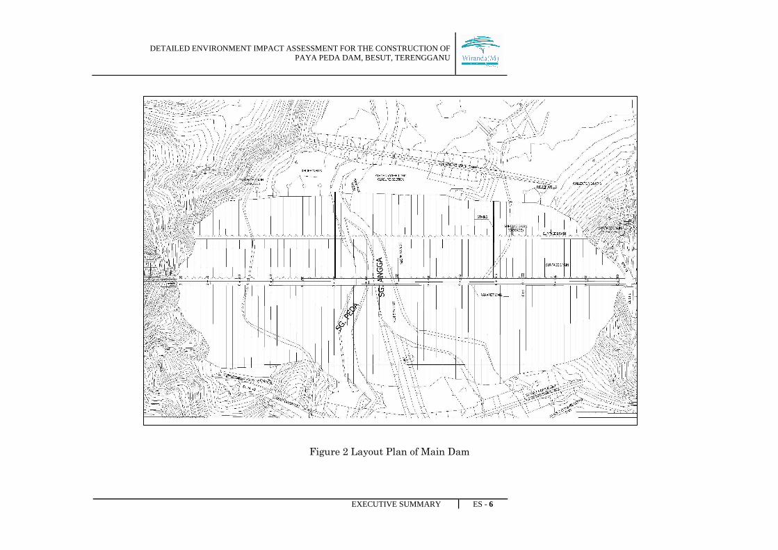
Figure 2 Layout Plan of Main Dam
DETAILED ENVIRONMENT IMPACT ASSESSMENT FOR THE CONSTRUCTION OF PAYA PEDA DAM, BESUT, TERENGGANU
EXECUTIVE SUMMARY ES - 7
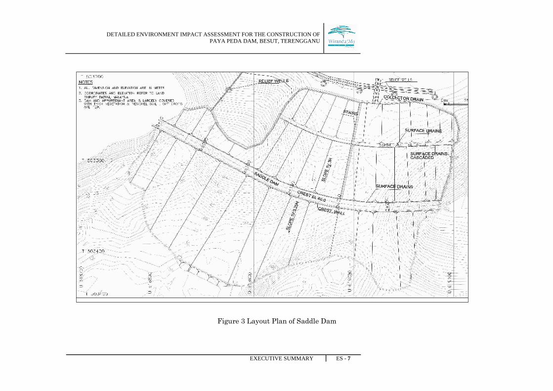
Figure 3 Layout Plan of Saddle Dam
DETAILED ENVIRONMENT IMPACT ASSESSMENT FOR THE CONSTRUCTION OF PAYA PEDA DAM, BESUT, TERENGGANU
EXECUTIVE SUMMARY ES - 8
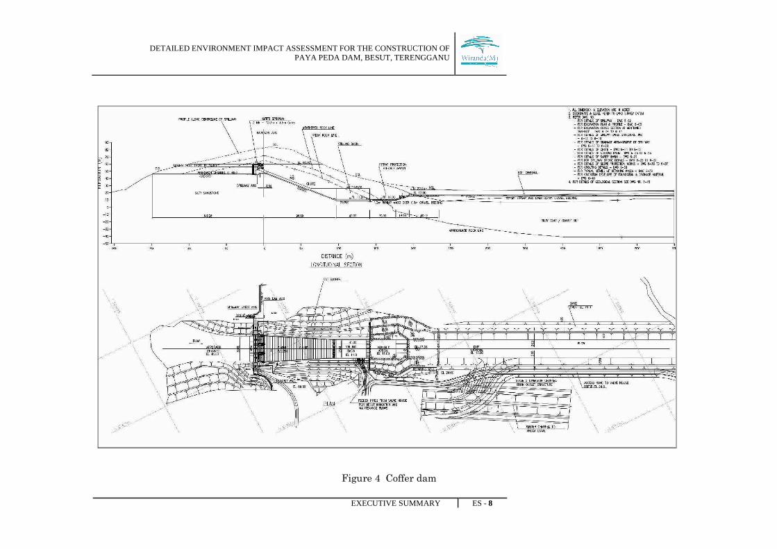
Figure 4 Coffer dam
DETAILED ENVIRONMENT IMPACT ASSESSMENT FOR THE CONSTRUCTION OF PAYA PEDA DAM, BESUT, TERENGGANU
EXECUTIVE SUMMARY ES - 9
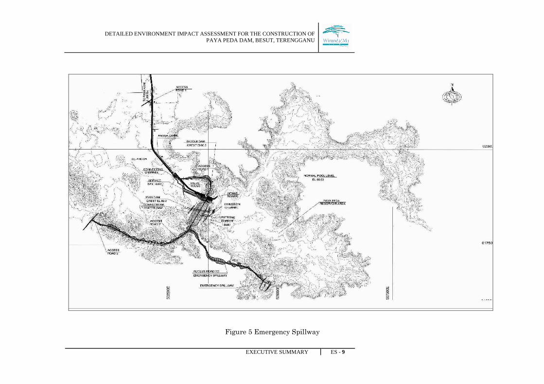
Figure 5 Emergency Spillway
DETAILED ENVIRONMENT IMPACT ASSESSMENT FOR THE CONSTRUCTION OF PAYA PEDA DAM, BESUT, TERENGGANU
EXECUTIVE SUMMARY ES - 10
4.2 DAM COMPONENTS
COMPONENTS DESCRIPTION
1. Main Dam i. It is an earthfilled zone located on Sg. Angga. It is 43 m
hight over the deepest foundation level and about 700 m
long on the top of axis. The crest level is set at EL 60.0 m.
ii. The main dam consists of:
a. Embankment slope
The adequate slope for embankment is 3 : 1 for downstream
side and 3 : 5 : 1 for upstream side. The downstream slope
has a 4 m wide horizontal berm at EL 40.
b. Embankment zones
The embankment shall have the following zones:-
- Impervious Earth Core: The width of core at top is
fixed as 4.0 m. Both upstream and downstream
slopes of the core are fixed at 0:5:1. The top of the
core is at EL 59.0 m, i.e, 1.0 m below the dam crest.
- Filters Zone: The transition between the impervious
earth core and outer random fill shell on the
downstream will be provided by one layer of coarse
filter sandwiches between two layers of fine filter
- Random Fill: Material classed as random fill shall
consists of silty clays, clayey silt, silty sand and
weathered, fractured and decomposed rocks mainly
conglomerate, siltstone or silty sandstone.
- Rockfill Shell: The rockfill material for outer shell
will be obtained mainly from sandstone/silty
sandstone and conglomerate from excavation of
spillway, outlet works and diversion tunnel.
DETAILED ENVIRONMENT IMPACT ASSESSMENT FOR THE CONSTRUCTION OF PAYA PEDA DAM, BESUT, TERENGGANU
EXECUTIVE SUMMARY ES - 11
- Riprap Zone: On the upstream slope, riprap layer of
8.0 m width has been provided. The material of this
layer consists of oversize rock stone meeting the
requirements to withstand the water waves.
- Downstream Face (Turfing): Protection against
rain will be provided on the downstream face, by
placing sweet soil and close turfing. The thickness of
the sweet soil and close turfing will be 0.15 m.
c. Dam Crest
The crest of the embankment including road formation has
been set at EL 60.0 m. To cater for freeboard, the top of
parapet wall has been fixed at EL 61.0 m. The crest road is
provided with 40 mm bituminous wearing course surfacing
pla ed on 60 mm thick binder Course. The binder course is
underlain by 300 mm road base and 150 mm subbase. The
subbase will be placed on top of random fill.
d. Parapet Wall
A conventional cantilever type concrete parapet wall has
been provided at the dam crest. It is 1.55 m high, projecting
1 m above the crest road. The top of wall has been fixed on
the basis of freeboard and camber requirements. Its top
level varies from EL 62.40 m at the maximum section to EL
61.0 m towards abutment. The wall has been designed to
withstand wave impact and load from embankment fill.
e. Freeboard and Crest Level
Since avoidance of overtopping is a prime design
requirement for a dam, adequate freeboard has been
provided. This vertical distance above normal pool level to
the dam crest includes
DETAILED ENVIRONMENT IMPACT ASSESSMENT FOR THE CONSTRUCTION OF PAYA PEDA DAM, BESUT, TERENGGANU
EXECUTIVE SUMMARY ES - 12
- Rise in water level to pass spillway design flow or
flood surcharge
- Rise in water level due to wind action which
comprises of wind set up, wave height and wave
run up
- Additional provision towards contingencies due to
any inaccuracy in hydrological parameters
2. Saddle Dam i. The saddle dam shall be located at a distance of about 200m
on the right side of the main dam. It will complete the
reservoir rim by closing a saddle between two hills, having
lowest point at EL 30.0 m. The maximum height of the dam
above lowest ground level will be nearly 30.0m with the crest
length of about 300 m. The dam is designed as zoned earthfill
embankment with central earth core as of the main dam.
ii. The design features for saddle dam is same like main dam
design, except that the saddle dam embankment is placed
on lateritic soil overburden.
3. Service Spillway i. The service spillway is located on the right side of the main
dam. A gated ogee spillway has been adopted for flood
control and flood routing characteristic
A 35.0 m wide approach channel with its bed excavated to
EL 46.0 m, leads the water to a 30.9 m long weir which has
its crest located at EL 52.0 m. The overall width of the crest
is 35.0 m with two number of 2.05 m wide piers. Three (3)
10.3 m wide and 4.66 m high radial gates will be installed
in the three bays of the spillway. The top of the gate will be
about 0.3 m above the normal pool level at EL 56.0 m to
avoid overflows in normal conditions.

DETAILED ENVIRONMENT IMPACT ASSESSMENT FOR THE CONSTRUCTION OF PAYA PEDA DAM, BESUT, TERENGGANU
EXECUTIVE SUMMARY ES - 13
ii. Design Discharge
Service spillway is a gated structure. Spillway capacity
should be sufficient to cater probable maximum flood (PMF)
in as much as the dam is an earthfill embankment. The
spillway was also designed for PMF condition. An ungated
overflow type of spillway was proposed for a design discharge
of 733 m3/s. The design discharge was based on PMF inflow
peak of 1806 m3/s which was routed with spillway crest at
EL 50.50 m resulting in a flodd surcharge of 2.95 m and
outflow discharge of 733 m3/s. Effective length of the spillway
considered was 61.20 m
iii. The service spillway consists of:
a. Apron Slab
The apron slab is reinforced concrete slab on grad. This is
a 0.3 m thick slab which has no applied force acting on it.
This has been designed for temperature and shrinkage
stresses.
b. Non Overflow Section
Non overflow sections are provided on both sides of the
ogee crest to connect the overflow section with the
abutments. The non overflow sections are mass concrete
gravity structures placed on the cut slopes of the spillway
abutment.
c. Ogee Weir
This is a massive structure and has been designed for
temperature and shrinkage stresses. The spillway weir is
of the gated concrete overflow type. It has an ogee shaped
DETAILED ENVIRONMENT IMPACT ASSESSMENT FOR THE CONSTRUCTION OF PAYA PEDA DAM, BESUT, TERENGGANU
EXECUTIVE SUMMARY ES - 14
crest with rounded abutments and piers. The crest
elevation is set at 52.0 m and the total crest length is 30.9
m i.e (3 X 10.3 m). Effective length of the crest has been
taken as 30.9 m. The weir shall have a nappe shaped crest.
d. Pier Walls
These are vertical walls embedded in the floor slab and
take two major loads. The first is the load of the spillway
bridge for which the wall is designed as a compression
member.
e. Abutments
The difference of the abutments from the piers is that the
abutments sustain an additional load of the retained
earth. All vertical reinforcement on the backfill side has
been provided to resist lateral earth pressure from the
retained earth.
f. Chute
The portion of the spillway channel below the control weir
is the chute. The invert gradient for the chute has been
selected to place the foundation on sound rock as assessed
by the site investigation and topography. Accordingly a
slope of 2 : 5 : 1 is provided for chute floor.
g. Stilling basin
A hydraulic jump type stilling basin shall be provided for
dissipating the excess energy of incoming flows.
Parameters for the basin have been worked out for a 1000
year outflow discharge i.e, 546 m3/sec. Maximum velocity,
at the toe is worked out as 26.35 m/s.
DETAILED ENVIRONMENT IMPACT ASSESSMENT FOR THE CONSTRUCTION OF PAYA PEDA DAM, BESUT, TERENGGANU
EXECUTIVE SUMMARY ES - 15
h. Spillway bridge
A bridge with its crest at EL 60.0 m is provided along the
axis of spillway crest in order to provide access. The bridge
is 5.0 m wide and 35 m long.
i. Approach Channel
About 137 m long and 35 m wide approach channel having
straight alignment leads the flow to the service spillway
ogee. The approach to the weir has been kept in such a
way that the flow shall take place unobstructed without
causing any adverse inlet condition over the whole range
of reservoir levels.
j. Tailwater Rate
The Angga barrage located at about 424 m donstream of
the confluence of spillway channel with Sg. Angga controls
the tailwater levels for the spillway at lower discharge. For
higher discharge the Sg. Angga appears to have little
effect on the tail water rating curves as the water surface
encroaches the river bank terraces.
4. Outlet Structure i. The outlets works include intake tower, vertical shaft, steel
conduit of 2.75 m diameter passing through the diversion
tunnel, and valve housed to distribute and discharge the
water released for different purposes. The intake tower,
diversion tunnel, valve houses are located between the right
abutment of service spillway and the left abutment of
saddle dam
ii. The present design discharge arrangement of water
releases in peak season is as follows:-

DETAILED ENVIRONMENT IMPACT ASSESSMENT FOR THE CONSTRUCTION OF PAYA PEDA DAM, BESUT, TERENGGANU
EXECUTIVE SUMMARY ES - 16
- Besut Irrigation System and maintenance
Flows for Sg. Angga
18 m3/s
- Angga Canal irrigation System 7.2 m3/s
- Besut Water Supply 3 m3/s
- Upstream high Areas of Angga Canal
irrigation System
0.6 m3/s
- Total water releases 28.8 m3/s
iii. The outlet structure consists of:-
a. intake Tower
The intake tower is connected from the maintenance deck at
EL 56.30 m to the bottom of the vertical shaft at EL 19.83 m
in the diversion tunnel by using gantry crane. This bulk head
will only be used for the maintenance of the outlet conduit
pipes
b. Access bridge
The bridge is designed for the access to the intake tower for
maintenance purpose as well as transporting equipment
using small trucks.
c. Outlet Pipes
For irrigation system of Angga Canal, the main pipe is
reduced to 0.92 m diameter pipe before cone valve, using 3
reducers. The discharge through this cone valve will be 7.2
m3/s. For Besut water supply system, one pipe of 1.5 m
diameter originates from on the right side. Gate valve is
provided at the start of maintenance purpose.
DETAILED ENVIRONMENT IMPACT ASSESSMENT FOR THE CONSTRUCTION OF PAYA PEDA DAM, BESUT, TERENGGANU
EXECUTIVE SUMMARY ES - 17
d. Valve House
The flows to Sg. Angga and Angga canal will be regulated by
fixed-cone valves installed at the downstream end of each
pipe in the valve house. The valve house for Angga canal will
be in front of the downstream diversion portal. The valve
house for the besut Irrigation Scheme will be located at the
right side of the service spillway stilling basin.
e. Exit Channel and Feeder Channel
Discharge from the valve house 1 for Angga canal irrigation
scheme (7.2 m3/s) will fall into a stilling basin provided
downstream of the valve house. The outlet discharge for besut
Irrigation scheme amounts to 18 m3/s. This discharge will be
released through two (2) – 1.06 m diameter valves located at
the valve house 2.
f. Outlet Discharge
The sizes of the valves are designed to provide a design
discharge of 9 m3/s and 7.2 m3/s at reservoir level of EL 37 m.
The sizes for the valves come out to be 1.06 m and 0.92 m
diameter.
5. Diversion Tunnel i. The diversion scheme is required to provide dry area for the
construction of main dam. It will be carried out in two
stages. In the first stage, flows will be diverted towards a
diversion channel on the right side of the river, whereas in
the second stage flows will be passed through a concrete
lined inverted U-shaped diversion tunnel, 5 m wide and 5 m
high, to be located on the right side of the service spillway.
Two cofferdam will be constructed, one upstream and other
downstream, to allow construction of the main dam. The
diversion tunnel located along the left abutment of
DETAILED ENVIRONMENT IMPACT ASSESSMENT FOR THE CONSTRUCTION OF PAYA PEDA DAM, BESUT, TERENGGANU
EXECUTIVE SUMMARY ES - 18
saddle dam
ii. The tunnel has been designed to cater a 25 – year
frequency flood with inflow of 95 m3/s and routed
outflow of 58 m3/s. For the discharge, depth of flow in
the tunnel is about 3.9 m with velocity of about 2.69
m3/s.
iii. The Cofferdam
The cofferdam will be constructed upstream and
downstream of the main dam toe extending from the river
bank to both abutments leaving a gap of 20 m in-between to
allow for the stage 1 diversion channel.
6. Reservoir i. Spillway capacity should be sufficient to cater probable
maximum flood (PMF) safely as much as the dam is an
earthfill embankment. The probable maximum
precipitation (PMP) for the dam catchment area has
estimated as 3183 m3/s
ii. The filling studies were determined from simulated
rainfall runoff studies using rainfall data between 1948 to
2006. The inflow volume is computed based on the product
of the monthly runoff and a catchment area of 77km2 .
7. Emergency
Spillway
i. The emergency spillway is located at the left periphery of
the reservoir about 2.5 km upstream of the main Dam.
Access to the emergency spillway will be provided by an
access road, starting from the main dam along the left
periphery of the reservoir.
ii. Design Discharge
A comparison of outflows and surcharge for the above crest
lengths suggested that 30 m for service spillway and 150 m
for emergency spillway is the most appropriate length of
weirs and has therefore been adopted. The routing results
DETAILED ENVIRONMENT IMPACT ASSESSMENT FOR THE CONSTRUCTION OF PAYA PEDA DAM, BESUT, TERENGGANU
EXECUTIVE SUMMARY ES - 19
show that the outflow discharge shall be the order of
954 m3/s, with a flood surcharge of about 2.5 m above
the emergency spillway crest at EL 56.30 m.
iii. the structural design of emergency spillway consists of:-
a. Approach Channel
About 68 m long and 153 m wide approach channel having
straight alignment leads the flow to the emergency
spillway ogee. The approach to the weir has been kept in
such a way that the flow shall take place unobstructed
without causing any adverse inlet condition over the whole
range of reservoir levels.
b. Ogee Weir
The spillway weir is an ungated concrete overflow ogee
shaped crest. The crest elevation is set at EL 56.30 m and
the crest length is 150 m. the weir shall have a nape
shaped crest. Upstream face be vertical. This is a massive
structure and has been design for temperature and
shrinkage stresses.
c. Chute
The portion of the spillway channel below the control weir
is the chute. The width of the chute channel converges
from 35 m at the downstream base of the control weir to 25
m at a distance of 93 m (horizontal) downstream from the
start point of convergence, giving a nominal divergence
ration of 1: 18.
d. Stilling Basin
A hydraulic jump type stilling basin shall be provided for
dissipating the excess energy of incoming flows.
DETAILED ENVIRONMENT IMPACT ASSESSMENT FOR THE CONSTRUCTION OF PAYA PEDA DAM, BESUT, TERENGGANU
EXECUTIVE SUMMARY ES - 20
Parameters for the basin have been worked out of PMF
outflow discharge, i.e, 954 m3/s.
e. Tailwater Rate
The discharge below the stilling basin will join Sg. Bekok
(a river opening in the adjacent valley). The exit channel
will be lined with riprap and bedding having a bed width
of 153.5 m up to a length of 50 m downstream of the
stilling basin.

DETAILED ENVIRONMENT IMPACT ASSESSMENT FOR THE CONSTRUCTION OF PAYA PEDA DAM, BESUT, TERENGGANU
EXECUTIVE SUMMARY ES - 21
4.3 CONSTRUCTION ACTIVITIES
ACTIVITY DESCRIPTION
1. Site Preparation
- In the reservoir area, the clearing will begin at the rivers
and the vegetation will be cleared away from the rivers.
This will also ensure that the fauna can escape from the
area.
- Given that the construction sites and the reservoir area are
located in the national-conservation-forests, many of the
trees are valuable. These can be removed and sold.
i. Removal and
Disposal of
Vegetation
ii. Constructing
Access Road
- There are existing tracks or roads can be used, which
through Bukit Payung and Telekom Tower.
iii. Temporary
Drainage
- The temporary drainage to be constructed to guide the
generated runoff/overland flows from the project site to the
existing waterways. The slope at cut area shall be 1:1.5
with close turfing while fill area shall be 1:2 slopes with
close turfing.
iv. Dam
Construction
By Year I, the following activities will be done:-
- Excavation of diversion channel
- Foundation Treatment for main dam around area A
abutment (i.e. Grouting)
- Foundation treatment for saddle dam
- Start of excavation for service spillway
- Start of excavation tunnel portals
By Year II, the following activities will be done:-
- Access Roads and building works
- 1st stage Coffer dam including sheet piling
- Main dam between EL.8.0 m to EL 30.0 m along both
DETAILED ENVIRONMENT IMPACT ASSESSMENT FOR THE CONSTRUCTION OF PAYA PEDA DAM, BESUT, TERENGGANU
EXECUTIVE SUMMARY ES - 22
abutments
- Saddle dam up to EL 60.0 m
- Excavation of Service Spillway, grout curtain, drainage
system and rock anchors
- Start of concreting in service spillway
- Emergency spillway
- Start of concreting in tunnel and shaft
By Year III, the following activities will be done:-
- Access Roads and Building Works
- Main dam up to EL 60.0 m along both abutments
- Construction of Service Spillway except gates
- Construction of diversion tunnel including lining
By Year III, the following activities will be done:-
- 2nd stage Coffer dam
- Diversion of river through tunnel
- Main dam up to EL 60.0 m in the central portion of the
river
- Construction of service Spillway and gates
iv. Diversion Works - Stage 1 : Diversion of river flow towards the left bank of
the river. In order to construct the cofferdams in dry, a
temporary channel will be constructed to divert the flows to
Sg. Angga and clear the area for the stage 1 diversion
channel works. After construction of the stage 1 channel,
the temporary channel will be abandoned and the water
will start flowing through the stage 1 diversion channel.
- Stage 2 : Diversion of stream flow through diversion
tunnel. When all the above works are successfully
completed, the streamflow will be diverted through
DETAILED ENVIRONMENT IMPACT ASSESSMENT FOR THE CONSTRUCTION OF PAYA PEDA DAM, BESUT, TERENGGANU
EXECUTIVE SUMMARY ES - 23
diversion tunnel and the flow through the Stage 1 diversion
channel shall be closed by a plug between the two parts of
the upstream cofferdam. The closure of the diversion
channel shall be made in the beginning of dry season.
- Stage 3 : Diversion of river flows through the diversion
tunnel. When construction of the main dam is completed to
the crest level, the mouth of the diversion tunnel should be
closed by dropping bulkhead gate. The reservoir filling will
thus start.
v. Reservoir Filling There following salient steps that should be undertaken
during reservoir filling activities:-
- All vegetation within the reservoir area should be cleared
and removed before filling activity
- Ensure all the water outlets for the dam were closed, to
avoid any discharge from the reservoir
- Ensure all system that been installed is functioning, to
monitor every single occurrence during filling activity
- Investigate/monitor if there any seepage within the dam
core
- Identify if there any failure of the system and
component/structures of the dam
DETAILED ENVIRONMENT IMPACT ASSESSMENT FOR THE CONSTRUCTION OF PAYA PEDA DAM, BESUT, TERENGGANU
EXECUTIVE SUMMARY ES - 24
5.0 EXISTING ENVIRONMENT
5.1 Physical
5.1.1 Topography
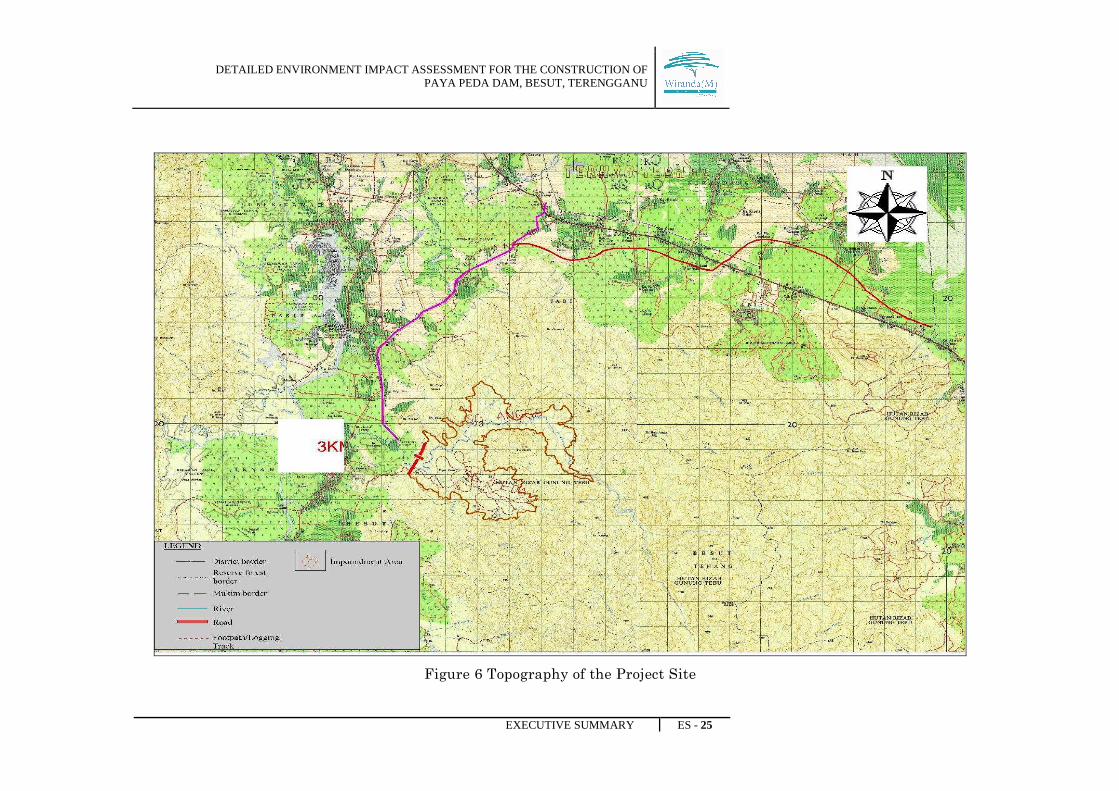
The proposed project area will involve approximately 1,212 ha of land which is covered
with secondary forests. The main river is Sg. Angga with two sizeable tributaries and a
number of other smaller streams. One of the tributaries is Sg. Peda joining Sg. Angga
from right side at a location about 7.5 km below the latter’s originating point. Sg. Peda
originates from Bt. Kajang at EL. 1000m. Another major tributary of Sg. Peda
originating from the western hill range at EL. 780m joins the river just upstream of the
proposed dam site. The elevation along the hill range drops from about 1000 m to nearly
90 m at the dam site where the river bed level is at about EL. 17.0 m. The major portion
of the area consists of forest clad hills. The area below EL. 50 m forms comparatively
flatter terrain.
DETAILED ENVIRONMENT IMPACT ASSESSMENT FOR THE CONSTRUCTION OF PAYA PEDA DAM, BESUT, TERENGGANU
EXECUTIVE SUMMARY ES - 25
Figure 6 Topography of the Project Site
DETAILED ENVIRONMENT IMPACT ASSESSMENT FOR THE CONSTRUCTION OF PAYA PEDA DAM, BESUT, TERENGGANU
EXECUTIVE SUMMARY ES - 26
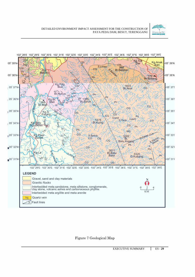
5.1.2 Geology
Terrain Geological Mapping
The study for geological observation covers an area of 110 km2 or 11,000 ha. The geology
of the study area is covered by three main litologies;
1. Carbonaceous to Cretaceous metamorphic rocks;
2. Sedimentary rocks and
3. Granitic rocks.
The metamorphic rocks consist of quartzitic sandstone; siltstone, conglomerate, and
carbonaceous shale which belong to Telemong and Keruak Formations. Tapong and
Bukit Puteri Formations are the younger formation (tertiary), consisting of interbedded
sandstone and siltstone and conglomerate beds.
All the formations are overlain by alluvium of the Quaternary deposits. These rock
formations were deformed and metamorphosed into metamorphic rock caused by late
deformation due to granite intrusions. The Granitic rocks consist of Granite to Granite-
Diorite of the Lawit Granite and Granite biotite hornblende of the Boundary Range
Granite. These two granites have historical series of emplacement from the Cretaceous
up to the Upper Carbonaceous.
Geological Structure
Geological structures such as bedding, foliation, joint and fault contribute to slope
instability in natural and manmade slopes.
i) Bedding planes
Bedding planes are a kind of sedimentary structure as well as a discontinuity plane that
separates a layer of sedimentary rock from another. Most of the readings for the
strike/dip were carried out on sedimentary outcrops located along the road and Angga
River. The orientation of bedding plane was found to vary from one place to another.
DETAILED ENVIRONMENT IMPACT ASSESSMENT FOR THE CONSTRUCTION OF PAYA PEDA DAM, BESUT, TERENGGANU
EXECUTIVE SUMMARY ES - 27
The bedding planes recorded in this area strike predominantly N-S and NW-SE and dip
towards northeast and southwest.
ii) Fault Line
Faults structures are discontinuity planes associated with movement in rocks. The
regional structure of the fault can be interpreted based on trend of negative lineament
such as rivers and valleys. The satellite image indicates considerable alignment of
gullies and ridges to form topographic lineaments. This fault is at some distance from
the proposed Peda dam. Other than this, there seem to be no faults crossing the
proposed dams and its facilities.
Geotechnical Aspects
The structural geology is a component that reflects the geotechnical aspect. Distribution
and frequency of the geotechnical factors are influenced by trend and pattern of
structural geology such as beddings, joints, faults, schistosity planes.
The structural geology of this area is divided into two criteria: strike-slip fault and
negative lineament the strike-slip faults with direction to the left or to NNW due to SE
compression. In the northern, this fault was shifted the granite body about 3 km away
to the NNW. Sg. Angga was believed occupied along the fault zone. In the southern, the
presence of this fault was interpreted because no evidence supported its movement. The
negative lineaments were reflected either as stream lines or rivers, joint sets/ joint
systems or as fault zones (especially as normal faults). Most of the negative lineaments
existed in the metamorphic and sedimentary rocks, its formed coincide or after the first
deformation or during emplacement of granitic body in the study area. The presence of
these lineaments was disturbed the stability of bedding planes.
The expected location for landslide or other slope failure in the catchment area can
predicted along the crossing between negative lineaments, between beddings and
negative lineaments or between other geological structures. Soil erosion was occurred in
significant rate and this reflected to the formation of weathered rocks and also due to
DETAILED ENVIRONMENT IMPACT ASSESSMENT FOR THE CONSTRUCTION OF PAYA PEDA DAM, BESUT, TERENGGANU
EXECUTIVE SUMMARY ES - 28
encroachment of human kind. Thick sediments deposits were deposited along the river
bed, especially along the Sg. Peda.
The rock became unstable and falling down or sliding to the ground as rock fall or
landslide (for weathered rocks). The stability of rock in this area is very weak,
weathered rocks with high grade (5 or 6) are easily observed in the study area.
DETAILED ENVIRONMENT IMPACT ASSESSMENT FOR THE CONSTRUCTION OF PAYA PEDA DAM, BESUT, TERENGGANU
EXECUTIVE SUMMARY ES - 29
Figure 7 Geological Map
DETAILED ENVIRONMENT IMPACT ASSESSMENT FOR THE CONSTRUCTION OF PAYA PEDA DAM, BESUT, TERENGGANU
EXECUTIVE SUMMARY ES - 30
5.1.3 Soil
The mottled brown soils were normally seen wherever the residual soil profile was
developed. This type of soil was more common in the foundations for the Peda dam.
Thirteen topsoil samples from the Angga & Peda catchments were collected for physico-
chemical analysis. The composition of sand, silt and clay fraction in the soil varies. The
sand content ranged from 42 to 89%, silt content from 6 to 28% and clay from 5 to 37%.
High variation of particle size occurs between sampling stations probably due to the
different types of parent materials. Organic matter content is in the range of 2.28 to
9.74%.
5.1.4 Climates and Meteorological
Meteorological data used to describe the climatic conditions in the proposed project site
was obtained from the Meteorological Monitoring Stations in Kota Bharu and Kuala
Krai due to the fact that there is no Meteorological Monitoring Station in Besut.
Although there may be variations in the local weather and wind flows within the
proposed project site, the overall regional weather and wind flow influencing the area
should not be different.
Rainfall distributions in these two stations are influenced by the monsoonal wind
flow pattern. During the North-East Monsoon, both stations recorded the high total
rainfall. The monthly total rainfall for October was more than 250 mm and is was the
maximum recorded. There was less rainfall during the months of February to July.
However, during the inter-monsoon period (February and April), the total rain days
were slightly higher in 2003. These variations may be due to the long term effects of
the El-Nino phenomenon.

DETAILED ENVIRONMENT IMPACT ASSESSMENT FOR THE CONSTRUCTION OF PAYA PEDA DAM, BESUT, TERENGGANU
EXECUTIVE SUMMARY ES - 31
5.1.5 Landuse
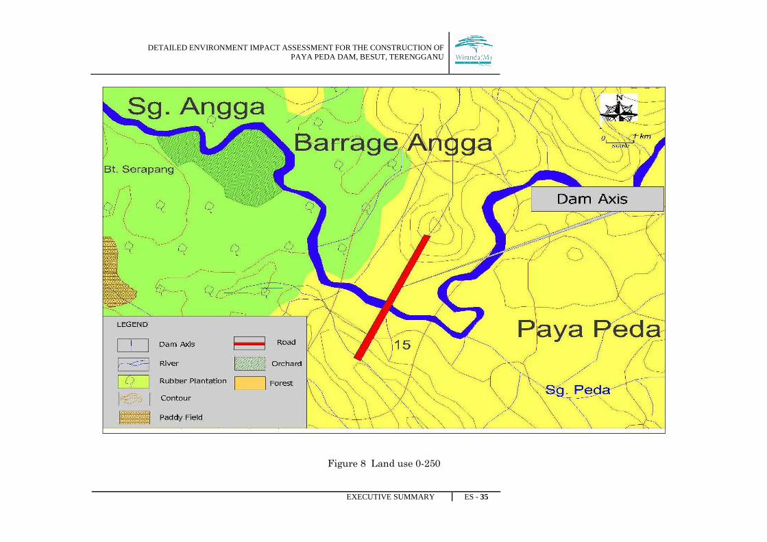
1.Land Use Activity within 250 meters Radial of the dam site
a. Forest Area Within 250-meter radial from the dam site the land
use types are mainly secondary forest and orchard
with some rubber trees. To the east and upstream
of the dam site is the swampy area which covers
about 50 ha of the Paya Peda confluence with
Sungai Angga. The secondary forest is the remnant
of the logged over forest that will be inundated.
b. Agriculture The orchard land and some rubber trees are located
on the western part of the proposed dam site near
the Angga Barrage. The land area to the west of
the dam site and downstream of the dam area is
planted with several fruit trees and intermittent
with rubber trees. There is no human settlement
found in this area.
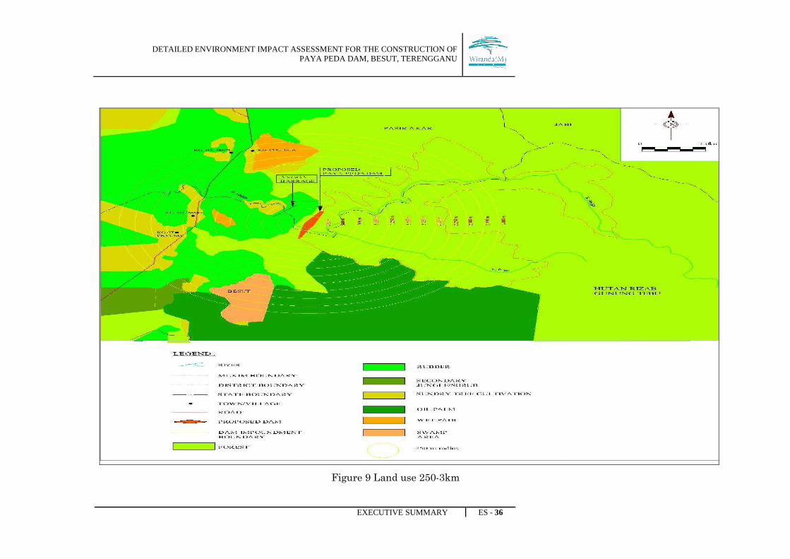
2.Land Use types within 3-KM Radial of the dam site.
a) Forested Land
The land area covers with swamp forest and
logged over forest. The land area is
undulating and covered with logged-over
forest.
The land area above the 100m mean sea
level until the 1000m mean sea level is
covered with forest known as the Gunung
Tebu Forest Reserve which also a production
forest area. The total land area under this
forested area is about 6,475 ha. Some part of
DETAILED ENVIRONMENT IMPACT ASSESSMENT FOR THE CONSTRUCTION OF PAYA PEDA DAM, BESUT, TERENGGANU
EXECUTIVE SUMMARY ES - 32
the forested area has been logged.
b) Plantation Area
Most of the plantation areas are located
outside the Angga catchment area. The
nearest plantation is FELDA Tenang locates
about 1000 meters to the south of the
proposed dam site over the southern
boundary of Sungai Angga. The oil palm
plantation (648 ha) is owned by the FELDA
Tenang and equipped with settlement,
utility and amenity . FELDA Tenang has
several facilities such as school,
administrative centre and settler’s quarters.
c) Orchards and
Rubber
smallholdings
The smallholding rubber and oil palm areas
are located outside the proposed dam area.
There are about 750 ha of rubber and
orchards land to the east of the Sungai
Besut and the proposed dam site. The
nearest rubber and orchard areas are found
about 100 meters to the west of the
proposed dam site.
d) Human
Settlement
The nearest settlement is Kg. Bukit Mali
which is about 2 km downstream of the
proposed dam site. The villages that are
heavily populated are Kg Bukit Payong in
Mukim Tenang and FELDA Tenang
settlement area. Kg Bukit Payong which is
located about 2100 meters to the southwest
of the dam site.
DETAILED ENVIRONMENT IMPACT ASSESSMENT FOR THE CONSTRUCTION OF PAYA PEDA DAM, BESUT, TERENGGANU
EXECUTIVE SUMMARY ES - 33
3. Land use activity within 10-km Radial from the proposed dam site
a. Forest Area
There are forest reserves such as the Gunung Tebu
Forest Reserve (within the project site and extent
between 16 kilometers north south direction and 18
km east west direction). The other forested area is
the Pelagat Forest Reserve located about 8 km to
the west of the project dam site which covers more
than 200 kilometer squares.
b. Agriculture Further downstream of the Angga Barrage and
downstream of Sungai Besut there are wet paddy
cultivation areas near Kg. Pasir Akar and towards
Jerteh and Kuala Besut. In higher areas, the
agriculture activities include rubber and orchards.
Upper catchment area to the south of Kampong
Pasir Akar most of the land area is cultivated with
rubber and oil palm. Beyond these plantation areas
of above 150 m elevation the land is covered with
forest area.
In 3 km to 5 km, there are agricultural areas
covered with rubber, orchards, and oil palm,small
holdings, FELDA Tenang andFELDA Dengir

DETAILED ENVIRONMENT IMPACT ASSESSMENT FOR THE CONSTRUCTION OF PAYA PEDA DAM, BESUT, TERENGGANU
EXECUTIVE SUMMARY ES - 34
c. Human Settlement The human settlements which comprise of small
villages are well distributed along the river bank or
the main roads. Those settlements located to the
north of the project site includes Kg. Bukit Piatu (3
km), Kg Mat Air (3.8km),
Kg. Baharu (5.4km) and Kg. Pasir Akar (6.2km).
Villages located to the west and south west of the
dam site are Felda Tenang(3.0km), Kg. Batu 13
(5km), Kg.Pasir Badak (6.7km) and Kg. La (9km).
Central Forest Spine The proposed project area has been identified as an
Environmentally Sensitive Area under the
Malaysian National Physical Plan shows that the
Malaysian federal government has labelled the
area as part of Central Forest Spine – Forest
Complex 2 (Taman Negara – Banjaran Timur)
DETAILED ENVIRONMENT IMPACT ASSESSMENT FOR THE CONSTRUCTION OF PAYA PEDA DAM, BESUT, TERENGGANU
EXECUTIVE SUMMARY ES - 35
Figure 8 Land use 0-250
DETAILED ENVIRONMENT IMPACT ASSESSMENT FOR THE CONSTRUCTION OF PAYA PEDA DAM, BESUT, TERENGGANU
EXECUTIVE SUMMARY ES - 36
Figure 9 Land use 250-3km
DETAILED ENVIRONMENT IMPACT ASSESSMENT FOR THE CONSTRUCTION OF PAYA PEDA DAM, BESUT, TERENGGANU
EXECUTIVE SUMMARY ES - 37
Figure 10 Land use 3km-10km
DETAILED ENVIRONMENT IMPACT ASSESSMENT FOR THE CONSTRUCTION OF PAYA PEDA DAM, BESUT, TERENGGANU
EXECUTIVE SUMMARY ES - 38
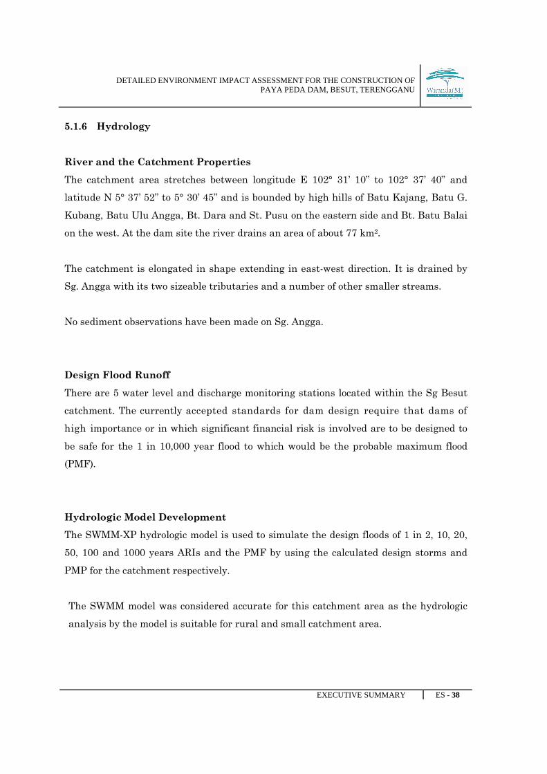
5.1.6 Hydrology
River and the Catchment Properties
The catchment area stretches between longitude E 102° 31’ 10” to 102° 37’ 40” and
latitude N 5° 37’ 52” to 5° 30’ 45” and is bounded by high hills of Batu Kajang, Batu G.
Kubang, Batu Ulu Angga, Bt. Dara and St. Pusu on the eastern side and Bt. Batu Balai
on the west. At the dam site the river drains an area of about 77 km2.
The catchment is elongated in shape extending in east-west direction. It is drained by
Sg. Angga with its two sizeable tributaries and a number of other smaller streams.
No sediment observations have been made on Sg. Angga.
Design Flood Runoff
There are 5 water level and discharge monitoring stations located within the Sg Besut
catchment. The currently accepted standards for dam design require that dams of
high importance or in which significant financial risk is involved are to be designed to
be safe for the 1 in 10,000 year flood to which would be the probable maximum flood
(PMF).
Hydrologic Model Development
The SWMM-XP hydrologic model is used to simulate the design floods of 1 in 2, 10, 20,
50, 100 and 1000 years ARIs and the PMF by using the calculated design storms and
PMP for the catchment respectively.
The SWMM model was considered accurate for this catchment area as the hydrologic
analysis by the model is suitable for rural and small catchment area.
DETAILED ENVIRONMENT IMPACT ASSESSMENT FOR THE CONSTRUCTION OF PAYA PEDA DAM, BESUT, TERENGGANU
EXECUTIVE SUMMARY ES - 39
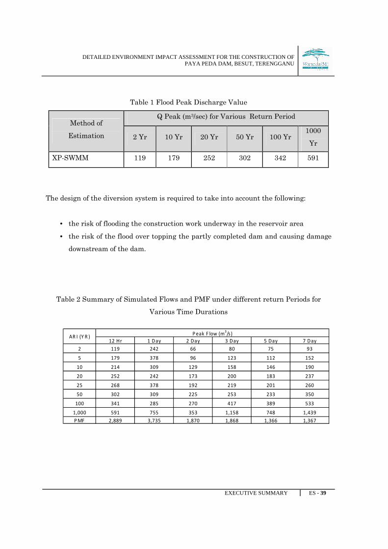
Table 1 Flood Peak Discharge Value
Method of
Estimation
Q Peak (m3/sec) for Various Return Period
2 Yr 10 Yr 20 Yr 50 Yr 100 Yr 1000
Yr
XP-SWMM 119 179 252 302 342 591
The design of the diversion system is required to take into account the following:
• the risk of flooding the construction work underway in the reservoir area
• the risk of the flood over topping the partly completed dam and causing damage
downstream of the dam.
Table 2 Summary of Simulated Flows and PMF under different return Periods for
Various Time Durations
12 Hr 1 Day 2 Day 3 Day 5 Day 7 Day
2 119 242 66 80 75 93
5 179 378 96 123 112 152
10 214 309 129 158 146 190
20 252 242 173 200 183 237
25 268 378 192 219 201 260
50 302 309 225 253 233 350
100 341 285 270 417 389 533
1,000 591 755 353 1,158 748 1,439
P MF 2,889 3,735 1,870 1,868 1,366 1,367
P eak F low (m3/s)
AR I (Y R )
DETAILED ENVIRONMENT IMPACT ASSESSMENT FOR THE CONSTRUCTION OF PAYA PEDA DAM, BESUT, TERENGGANU
EXECUTIVE SUMMARY ES - 40
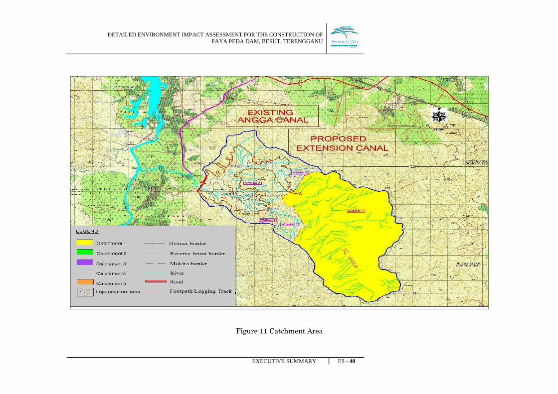
Figure 11 Catchment Area
DETAILED ENVIRONMENT IMPACT ASSESSMENT FOR THE CONSTRUCTION OF PAYA PEDA DAM, BESUT, TERENGGANU
EXECUTIVE SUMMARY ES - 41
5.1.7 Water Quality
Based on Malaysia Environmental Quality Report 2006 by Department of Of
Environment Malaysia, Sungai Besut was categorized as Class II (with overall WQI 90).
The results on the current study show that the water quality at the various sampling
stations fluctuate between Class I and Class II between seasons with the exception of
WQ10 (Confluence Sg. Pelagat and Sg. Besut near Jertih bridge) and WQ11a (Upstream
of Sg. Tembila). These two stations fell into the Class III category during the normal
season whereas WQ10 also fell into Class III during wet season. These variations at the
two stations are most likely associated with localized changes in the water quality
parameter due to localized inputs of pollutants since stations upstream and downstream
do not exhibit similar changes. The Project Proponent should continuously monitor the
results of the water quality analyses especially during the project implementation
phase. Corrective actions should be taken whenever and wherever deterioration of the
water quality occurs.
5.1.8 Air Quality and Noise
The ambient air quality in the study areas is found to be good. The ambient noise levels
at the study areas are also generally low, both characteristics typical of a rural setting.

DETAILED ENVIRONMENT IMPACT ASSESSMENT FOR THE CONSTRUCTION OF PAYA PEDA DAM, BESUT, TERENGGANU
EXECUTIVE SUMMARY ES - 42
Figure 12 Sampling locations for water air, noise
DETAILED ENVIRONMENT IMPACT ASSESSMENT FOR THE CONSTRUCTION OF PAYA PEDA DAM, BESUT, TERENGGANU
EXECUTIVE SUMMARY ES - 43
5.2 Biological
5.2.1 Flora
Overview of the tree species in the undisturbed forested areas within the proposed
project areas showed various timber species such as Shorea (Meranti, Balau, Damar),
Dipterocarpus (Keruing), Hopea (Merawan), Vatica (Resak), and Anisoptera (Mersawa).
The secondary or disturbed forested areas were mainly dominated by species from the
families of Euphorbiaceae, Arecaceae, Verbenaceae, Dipterocarpaceae, Ulmaceae,
Melastomataceae, Connaraceae, Clusiaceae, Burseraceae, Sapotaceae, Rutaceae,
Myristicaceae, Lauraceae, Gleicheniaceae, Dilleniaceae, Moraceae and Apocynaceae.
The species were very common in the disturbed forest areas which include Chromolaena
odorata, Mikania micrantha, Scleria sumatrensis, Smilax myosotiflora, Smilax setosa,
Smilax macrocarpa, Macaranga gigantea, Macaranga gigantea, Macaranga hypolueca,
Macaranga triloba, Endospermum diadenum, Trema cannabina, Trema orientalis,
Clerodendrum deflexum, Vitex pinnata, Vitex vestita, Pteris ensiformis, Nepenthes
gracilis, Spathogolttis plicata, Donax grandis, Clidemia hirta, Melastoma
malabatrichum, Mallotus paniculatus, Dicranopteris curanii, Dicranopteris linearis,
Sticherus truncatus, Tetracera scandens, and Blechnum orientale. These were indicating
the occurrence of disturbance of the surveyed area.
The riparian habitats indicated the presence of Tristaniopsis sp. (Pelawan) and Ficus
ischnopoda which was found abundantly along Sg. Angga. Other riparian tree species
include Myrica esculenta (Myricaceae), Teijsmanniodendron coriaceum (Verbenaceae),
Campnosperma auriculatum (Anacardiaceae), Anisophyllea disticha (Anisophylleaceae),
Mesua grandis (Clusiaceae), Mesua kochummeniana (Clusiaceae), Mesua racemosa
(Clusiaceae), Weinmannia fraxinea (Cunoniaceae), Dipterocarpus concavus
(Dipterocarpaceae), Dipterocarpus costulatus (Dipterocarpaceae), Shorea
balanocarpoides (Dipterocarpaceae), Shorea singkawang (Dipterocarpaceae), Ardisia
crenata (Myrsinaceae), Pometia pinnata (Sapindaceae) and Smilax calophylla
(Smilacaceae).
DETAILED ENVIRONMENT IMPACT ASSESSMENT FOR THE CONSTRUCTION OF PAYA PEDA DAM, BESUT, TERENGGANU
EXECUTIVE SUMMARY ES - 44
The epiphytes were mainly of the ferns (Aspleniaceae, Adiantaceae, Davalliaceae,
Dennsteadtiaceae, Hymenophyllaceae, Polypodiaceae and Vittariaceae) and orchids
(Bulbophyllum, Dipodium, and Coelogyne).
5.2.2 Fauna
The survey conducted by the consultant team recorded 36 species of mammals. A total
of 91 species from 38 families of birds were recorded at the survey sites. Out of the
total number recorded, 72 bird species are listed as totally protected and 6 bird
species are protected under the Protection of Wild Life Act, 1972 / 76, while another
13 bird species are not listed under the Act. A total of 11 birds are listed as near
threatened to extinction while one bird is considered vulnerable to extinction.
During the survey period, 17 amphibian species and 5 reptiles species have been
recorded.
5.2.3 Aquatic Ecosystem
Sg Angga and Sg Peda are fast running water bodies. Hence, the rivers ecosystem has
low phytoplankton populations ranging from only 0.2 cells per liter in Sg Peda upstream
to 8.0 cells per liter in downstream of Sg Besut. Diatoms were dominant while the rest
were Euglenoids, Cyanophytes and Chlorophytes (green algae).
A total of 54 species of fish were collected, observed or recorded from the information
gathered from villagers. Information provided by the villagers indicated that the
species, Tor tambroides (‘Kelah merah’ or Malayan masheer) has been extinct from Sg
Angga due to over fishing activities. A few species are also gradually disappearing due
to the same reasons i.e. Kelisa, Kejor and Tengas.
DETAILED ENVIRONMENT IMPACT ASSESSMENT FOR THE CONSTRUCTION OF PAYA PEDA DAM, BESUT, TERENGGANU
EXECUTIVE SUMMARY ES - 45
Some species of fishes in the study area are endemic especially in the fast running and
clear water of Sg Angga and Sg Peda, but all the species that have been recorded in this
study are widely distributed and could be found in various other rivers in Malaysia.
5.2.4 Socio Economic and Public Health
i) Human Environment
The proposed Paya Peda Dam project is located on Sg Angga about 7.5km from
confluence of Sungai Angga and Sungai Besut in Mukim Tenang, Besut District,
Terengganu. The upper catchment of Sungai Angga after the proposed dam site is
currently inhabited and within the Gunung Tebu Forest Reserve which covers an area
of about 7,700 hectares. The down stream area of the proposed dam site which is part of
the Sungai Besut river valley covers mainly of the agricultural land use (paddy land,
rubber, orchards and oil palm cultivation), traditional villages, Jertih Town, Kampung
Raja (Administration Centre) and Kuala Besut Town. Most of the population is
distributed in the lower valley of Sungai Besut. The upper Besut valley is mainly
covered with forested areas, agricultural area (rubber and oil palm small holders and
plantations) and traditional villages.
The total land area that will be acquired for the proposed project is about 1,467.56 ha
which comprises of 1,385.1 ha of government land and 82.44 ha of private land. The
government land includes the reservoir area upstream of the Dam Axis (1,328.64ha),
pockets of agricultural land and a small part of the forest reserve downstream of Sungai
Angga. The private land that will be acquired includes rubber land, orchard land and
open area that will be used for access road, office land , spill way, camp site, quarters
and other uses. For the construction of the access road to the dam site, 23 houses of
various types will be acquired.
DETAILED ENVIRONMENT IMPACT ASSESSMENT FOR THE CONSTRUCTION OF PAYA PEDA DAM, BESUT, TERENGGANU
EXECUTIVE SUMMARY ES - 46
It is anticipated that the State Government will generate revenue from the licensing of
logging activities plus the tax from the extraction of timber. The first revenue is the
premium paid by authorized loggers to the State Government for the land within the
inundated area.
With the Paya Peda Dam construction, the extension of the Angga canal could provide a
double cropping for the total area of 10,075 ha and a 95% functional system. With the
adequate irrigation water supply and good irrigation control, the paddy yield would be
able to increase from the 3.9 ton/ha in 2000 to 5 ton/ha once the irrigation scheme is
upgraded and improved at least by 2015 (KETARA 2006).
It is expected that with the construction of the Paya Peda Dam the 20-year flood at Kg.
Raja would be able to reduce the flood discharge from 2527m3/s to about 2027 m3/s. This
reduction in flood discharge at Kg Raja would reduce the flood area to about 440 ha of
land area under water. In terms of paddy production it could have saved about
RM418,000 per flood event.
With the construction of the Paya Peda Dam the supply of water for the district will be
about 121 MLD in 2020 which can support about 220,000 people (250 liters/person/day).
The total supply will require the construction of extra water treatment plants in order
to generate about 55MLD for domestic consumption only. Other water needs include the
industrial, commercial and institutional uses in the district.
For land acquisition, direct or indirect payment of money for land and property would be
the easiest and fastest means of compensation to those affected people. The registered
evaluation company or government evaluation office will evaluate the land value based
on the prevailing market price or other methods that are agreeable by both parties The
replacement of new area or land would be another alternative. If the government can
site a new land of the same value and properties then it would solve some of the critical
problems faced by those affected by the alienation program. Appropriate range of prices
for the type of land alienated shall be on the current market prices. For agriculture
land the price is about RM 12,000 per hectare. For rubber land it is about RM 17,000 to
DETAILED ENVIRONMENT IMPACT ASSESSMENT FOR THE CONSTRUCTION OF PAYA PEDA DAM, BESUT, TERENGGANU
EXECUTIVE SUMMARY ES - 47
RM 35,000 per hectare and generally for shop house in Jertih (RM 200,000, 2007). In
the urban fringe the single storey link houses may fetch a price is about RM 85,000 to
RM 125,000 per unit (Property Market Report, 2007).
ii) Public Health
Public health survey assessment has been carried out to describe the existing health
status and other health determinants especially the socio-economic status of the
population residing near the proposed Paya Peda Besut Dam site within 5km radius.
Public survey also had been done which focusing on who will be affected due to water
consumption from the dam and reservoirs water supply during their operational phase,
and in particular they were from two subdistricts: Pasir Akar and Felda Tenang and
comprised of six villages under Felda Tenang and ten villages under Pasir Akar, while
Kg Batu 13 was under both subdistricts.
From the study done, it was found that, Blastocystis hominis and Giardia duodenalis
which may lead to the infection of intestinal were the commonest protozoas detected in
the studied areas
The pattern of protozoan parasites infection for both places have shown is reliable due
to the moderate coverage (>50 %) from these villagers. All the species of protozoan
parasites found in this study was believed being transmitted to the infected childrens
via faecal – oral route transmission.
With the small percentage of positive prevalence, it indicates that the parasitic
infections has become a minor public health importance compared to some other places
nearby such as areas surrounding Tasik Kenyir for the Hulu Terengganu Dam Project
(based on technical report for Hulu Terengganu Dam project by Mazrura S et al, March
2008). However, with the existence of so called pathogenic or potentially pathogenic
DETAILED ENVIRONMENT IMPACT ASSESSMENT FOR THE CONSTRUCTION OF PAYA PEDA DAM, BESUT, TERENGGANU
EXECUTIVE SUMMARY ES - 48
parasites in this survey, early precautions and avoidance should be remarked because it
could be a sudden increased without any prior notice.
The three species helminth that have been found in all surveys were of medical
importance and well known as soil transmitted helminth in most part of the world. The
helminth can cause stunting, wasting, malnutrition and unfit physically among the
infected children.
The potential impact of the proposed dam to health of the public could be attributed to
development activities related to water resources and water reservoir. These health
impacts refer mainly to the risks of contracting waterborne and vector-borne diseases.
The baseline information shows that the health problem of this community is related to
the changes in the presence vectors and the water sources.
It should be emphasized that during this construction period, which extends over more
than two years, proper mitigating measures will be taken by contractors to ensure the
construction and the workers base-camp sites do not contain breeding sites for
mosquitoes to control the vector-borne diseases. They must also ensure proper
sanitation for the workers are provided to control transmission of other infectious
diseases. The Besut Health District Office undertakes an ongoing surveillance on
communicable and non-communicable diseases. The project proponent and the
contractor could collaborate with the health department to coordinate the activities of
this surveillance system
DETAILED ENVIRONMENT IMPACT ASSESSMENT FOR THE CONSTRUCTION OF PAYA PEDA DAM, BESUT, TERENGGANU
EXECUTIVE SUMMARY ES - 49
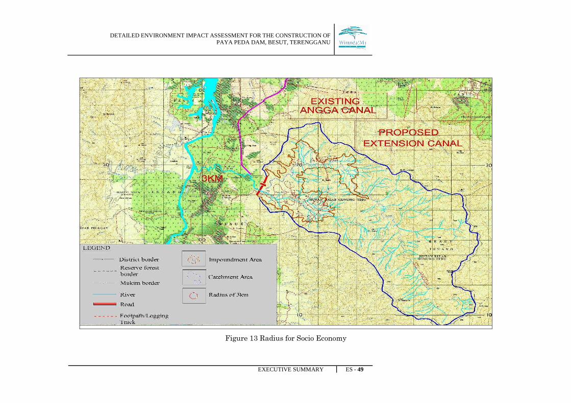
Figure 13 Radius for Socio Economy
DETAILED ENVIRONMENT IMPACT ASSESSMENT FOR THE CONSTRUCTION OF PAYA PEDA DAM, BESUT, TERENGGANU
EXECUTIVE SUMMARY ES - 50
6.0 ASSESSMENT OF IMPACT, MITIGATION MEASURE AND RESIDUAL
IMPACT
The potential impacts and the corresponding mitigating measures and residual impact
are summarised in Table ES-1. The main activities that will affect the natural
environment include site preparation, construction, operation and maintenance phases of
the project. Each development activity is assessed for its potential impacts on the
various physical, biological and socially components of the environment.
DETAILED ENVIRONMENT IMPACT ASSESSMENT FOR THE CONSTRUCTION OF PAYA PEDA DAM, BESUT, TERENGGANU
EXECUTIVE SUMMARY ES - 51
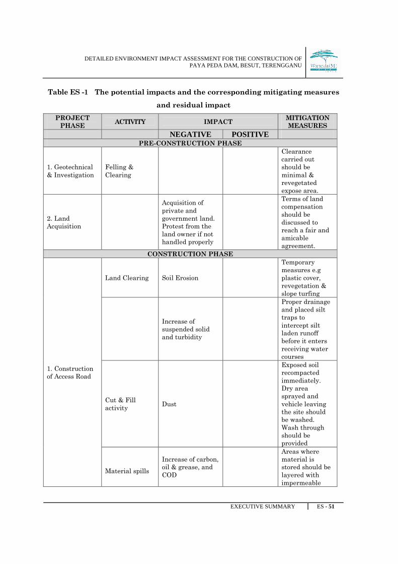
Table ES -1 The potential impacts and the corresponding mitigating measures
and residual impact
PROJECT
PHASE ACTIVITY IMPACT
MITIGATION
MEASURES NEGATIVE POSITIVE
PRE-CONSTRUCTION PHASE
1. Geotechnical
& Investigation
Felling &
Clearing
Clearance
carried out
should be
minimal &
revegetated
expose area.
2. Land
Acquisition
Acquisition of
private and
government land.
Protest from the
land owner if not
handled properly
Terms of land
compensation
should be
discussed to
reach a fair and
amicable
agreement.
CONSTRUCTION PHASE
1. Construction
of Access Road
Land Clearing Soil Erosion
Temporary
measures e.g
plastic cover,
revegetation &
slope turfing
Increase of
suspended solid
and turbidity
Proper drainage
and placed silt
traps to
intercept silt
laden runoff
before it enters
receiving water
courses
Cut & Fill
activity Dust
Exposed soil
recompacted
immediately.
Dry area
sprayed and
vehicle leaving
the site should
be washed.
Wash through
should be
provided
Material spills
Increase of carbon,
oil & grease, and
COD
Areas where
material is
stored should be
layered with
impermeable
DETAILED ENVIRONMENT IMPACT ASSESSMENT FOR THE CONSTRUCTION OF PAYA PEDA DAM, BESUT, TERENGGANU
EXECUTIVE SUMMARY ES - 52
base and bunded
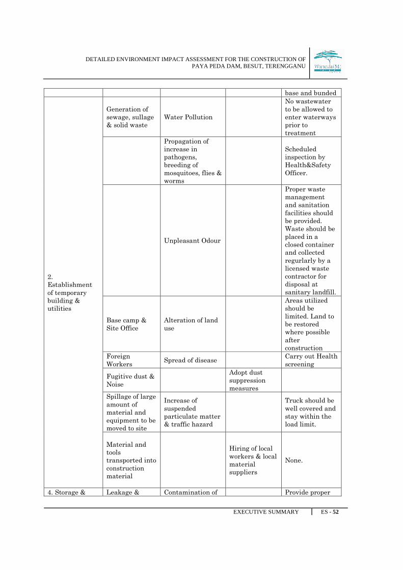
2.
Establishment
of temporary
building &
utilities
Generation of
sewage, sullage
& solid waste
Water Pollution
No wastewater
to be allowed to
enter waterways
prior to
treatment
Propagation of
increase in
pathogens,
breeding of
mosquitoes, flies &
worms
Scheduled
inspection by
Health&Safety
Officer.
Unpleasant Odour
Proper waste
management
and sanitation
facilities should
be provided.
Waste should be
placed in a
closed container
and collected
regurlarly by a
licensed waste
contractor for
disposal at
sanitary landfill.
Base camp &
Site Office
Alteration of land
use
Areas utilized
should be
limited. Land to
be restored
where possible
after
construction
Foreign
Workers Spread of disease
Carry out Health
screening
Fugitive dust &
Noise
Adopt dust
suppression
measures
Spillage of large
amount of
material and
equipment to be
moved to site
Increase of
suspended
particulate matter
& traffic hazard
Truck should be
well covered and
stay within the
load limit.
Material and
tools
transported into
construction
material
Hiring of local
workers & local
material
suppliers
None.
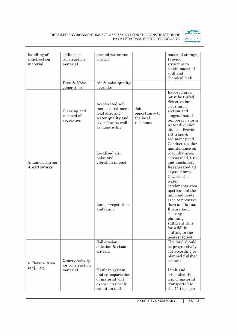
4. Storage & Leakage & Contamination of Provide proper
DETAILED ENVIRONMENT IMPACT ASSESSMENT FOR THE CONSTRUCTION OF PAYA PEDA DAM, BESUT, TERENGGANU
EXECUTIVE SUMMARY ES - 53
handling of
construction
material
spillage of
construction
material
ground water and
surface
material storage.
Provide
structure to
retain material
spill and
chemical leak.
Dust & Noise
generation
Air & noise quality
degrades
5. Land clearing
& earthworks
Clearing and
removal of
vegetation
Accelerated soil
increase sediment
load affecting
water quality and
river flow as well
as aquatic life.
Job
opportunity to
the local
residence
Exposed area
must be turfed.
Selective land
clearing in
section and
stages. Install
temporary storm
water diversion
ditches. Provide
silt traps &
sediment pond.
Localized air,
noise and
vibration impact
Conduct regular
maintenance on
road, dry area,
access road, tires
and machinery.
Regenerated all
exposed area.
Loss of vegetation
and fauna
Gazette the
water
catchments area
upstream of the
impoundments
area to preserve
flora and fauna.
Ensure land
clearing
planning
sufficient time
for wildlife
shifting to the
nearest forest.
6. Borrow Area
& Quarry
Quarry activity
for construction
material
Soil erosion,
siltation & visual
criteria
Haulage system
and transportation
of material will
expose an unsafe
condition to the
The land should
be progressively
cut according to
planned finished
contour
Limit and
scheduled the
trip of material
transported to
the 11 trips per

DETAILED ENVIRONMENT IMPACT ASSESSMENT FOR THE CONSTRUCTION OF PAYA PEDA DAM, BESUT, TERENGGANU
EXECUTIVE SUMMARY ES - 54
public especially
during peak hour.
day max.
7. Waste
disposal
Generation of
substantial
quantities of
waste material
Soil & Water
pollution
Proper disposal
of waste
material
8. Dam
construction &
related activity
River diversion
and
construction of
dam
A section of the
river will be
completely but
overall river
hydrology is
unaffected.
Siltaton may
obstruct the
stream flow.
Soil erosion
related problems.
Deterioration of
river in terms of
suspended
solid,turbidity etc
Significant
number of job
opportunities
will be created
Implement soil
erosion erosion
control plan, re-
vegetation and
slope turfing.
Construction of
tunnel
Unstable geology
condition due to
dam construction
Concrete
reinforcement at
weak rock zone
areas to
strengthen
geological
stability.
Land clearing
and
construction of
tunnel
Localized air,
noise & vibration
impact
Apply dust
suppression
measures
hearing
protection for
construction
workers, limit
work hours to
daytime
9. Reservoir
Filling &
• Failure in
component
Initial
monitoring to

DETAILED ENVIRONMENT IMPACT ASSESSMENT FOR THE CONSTRUCTION OF PAYA PEDA DAM, BESUT, TERENGGANU
EXECUTIVE SUMMARY ES - 55
Monitoring system of
the dam.
• The
potential
of any
leakage
detected
• Failure of
the
structure
strength
during the
reservoir
filling
the system
The construction
of the reservoir
structure should
follow the value
of factor of
safety.
OPERATION & MAINTENANCE PHASE
1.Water Supply
Reliable supply
of water to
meet the
expected
demand
2.River
Regulation
Reduced flow
downstream
Improved water
quality during
dry season.
Implement strict
pollution control
river basin.
3. Dam Break
Flooding
Prepare an
Emergency
Action Plan such
as relocation
program.
Detection from
system
developed –
SCADA.
4.Project
Abandonment
Material and
Machinery
Abandonment
Pollution of
waterways, visual
impacts etc
Adopt proper
abandonment
procedures.
7.0 ENVIRONMENTAL MANAGEMENT PLAN
DETAILED ENVIRONMENT IMPACT ASSESSMENT FOR THE CONSTRUCTION OF PAYA PEDA DAM, BESUT, TERENGGANU
EXECUTIVE SUMMARY ES - 56
The formulation of an Environmental Management Plan (EMP) is essential as part of
project planning and management throughout the whole development stages. The EMP
is an effective tool to minimise the environmental impacts that are imposed by the
development of such magnitude.
It is proposed that the project proponent prepares an Environmental Management Plan
(EMP) for the project. The EMP is a structured plan for the mitigation of predicted
environmental impacts through “best management practices”. The EMP will be
applicable to all contractors and their employees working in the project site. The EMP
outlines the compliance, best management practices, impacts and mitigation, and
recommended monitoring for all the required construction and operational activities
that will take place. In addition, it also includes environmental audits, emergency
response plan, and institutional and legislative arrangement for implementing the
above. The best endeavours in preparing EIA would be in vain if a proper
environmental management plan does not ensure the implementation of all mitigation
measures and the continued monitoring of the environment in the wake of project
development.
Beyond recommending best management practices and mitigation measures for
environmental impacts, the EMP includes an Environmental Monitoring Programme
which outlines the components and parameters for baseline, compliance and effects
monitoring, and an Implementation Plan which introduces how the overall EMP should
be implemented. The EMP can be further developed in conjunction with the planning
and coordination of the construction works so that the relevant control measures can be
suitably implemented at the appropriate time and place in order to be most effective.
The following are specific components of the EMP:
a) Allocation of Responsibility

DETAILED ENVIRONMENT IMPACT ASSESSMENT FOR THE CONSTRUCTION OF PAYA PEDA DAM, BESUT, TERENGGANU
EXECUTIVE SUMMARY ES - 57
To manage the environment in proper manner, a good and systematic
management program must be adopted, with strong emphasis on employee
education, regular monitoring, environmental auditing and employing best
management practices to prevent environmental issues from arising
whenever possible.
An Environmental Management Team (EMT) set up by the project proponent
is to implement, monitor, audit and report based on the Environmental
Management Plan (EMP) on all matters pertaining to the environment.
b) Environmental Regulation
This section describes all the related rules and regulations which the project
proponent has to abide by pertaining to the project. It will cover water
quality, air quality, wastewater discharges, noise level, earthworks, solid
wastes and scheduled waste.
c) Environmental Monitoring Programme
Environmental monitoring programme are essential in dam project in order
that the project activities are undertaken in an environmentally sustainable
manner. The monitoring programme is to ensure successful implementation
of the mitigation measures by contractor.
The scope under the proposed monitoring programme comprises the following
key tasks:
• Site inspection to assess the current progress of construction works
on site.
• Monitoring of water quality, discharge from silt traps, air quality,
noise levels, waste management, flora and wildlife management to
DETAILED ENVIRONMENT IMPACT ASSESSMENT FOR THE CONSTRUCTION OF PAYA PEDA DAM, BESUT, TERENGGANU
EXECUTIVE SUMMARY ES - 58
assess environmental conditions against work progress and
intensity.
• Analysis of the monitoring results and formulation and
recommendations on suitable measures for areas of non-
compliance and/or enhancement of environmental quality.
Based on the information described, it is recommended that environmental
impact monitoring of the project be implemented according to the following
sampling locations, frequency of sampling and analytical methods.
d) Remedial Action
This section outlines specific construction activities in the project and
addresses work specifications and codes, and adherence to specific work
practices and ethics to avoid or minimise damage and interference to
watercourses or drainage systems, utilities, structures, roads or other
property, and trees. The corresponding mitigating measures are summarised
in Table ES-1.
e) Emergency Response Plan
An Emergency Response Plan (ERP) must be prepared for emergency
situations during the construction and operations of the project. The ERP
shall be integrated as part of the project inculcating general awareness on
safety, health and environment.
1. ERP During Construction Phase
This ERP covers activities, services and products that may create
potential accidents and emergency situations during construction phase

DETAILED ENVIRONMENT IMPACT ASSESSMENT FOR THE CONSTRUCTION OF PAYA PEDA DAM, BESUT, TERENGGANU
EXECUTIVE SUMMARY ES - 59
such as fire, spillage, structure collapse, medical emergency, landslide,
flood and general accidents.
The Contractor should establish site Emergency Response Team (ERT).
The ERT will prepare the appropriate ERP for each situation. All staff is
responsible to understand ERP and response procedures and evacuation
routes and to follow the instructions of the designated Safety Officer. The
emergency plan shall be the responsibility of the Project Manager who
shall also oversee environmental, health and safety matters.
The ERP should be displayed at related area such as site office, workshop,
guard station, canteen and workers quarters. The ERT should conduct
periodical training for the ERP and ensure emergency response
equipment are tested were applicable at least once a year. The ERT also
should review and revise the ERP at least once a year particularly after
the occurrence of accidents or emergency situations.
2. ERP During Operation Phase
This Emergency Response Plan (ERP) is prepared based on the dam
break study. The objective of the ERP is to prepare Paya Peda Dam and
its staff for a wide range of emergencies that may arise due to :
• Failure of, or damage to, system infrastructure;
• The potential for such failure to cause injury or loss of life of
employees and/or the public;
• Natural events leading to disastrous situations in regard to assets
managed by JPS KETARA.
The aim of the ERP is to enable JPS KETARA to know what to do and
how to apply its resources quickly and effectively in the case of dam
failure to minimise the impending damage.
DETAILED ENVIRONMENT IMPACT ASSESSMENT FOR THE CONSTRUCTION OF PAYA PEDA DAM, BESUT, TERENGGANU
EXECUTIVE SUMMARY ES - 60
The ERP are:
• To establish the manner in which all emergencies are to be
reported.
• To define the responsibilities of JPS KETARA employees in the
reporting process.
• To define the actions and responsibilities of JPS KETARA
employees in the event of an emergency.
• To ensure that combat and other support agencies are provided
with reliable source of information if they are called upon to
address an emergency associated with assets controlled by JPS
KETARA.
• To ensure that the plan provides a ready reference document
which clearly establishes the procedures to deal with all
emergencies in quick, efficient and safe manner.
f) Catchment Management Plan
A Catchment Management Plan (CMP) is important to secure and maintain a
reliable water supply to the proposed dam. It is necessary to ensure that the
natural environment of the catchment area of the dam is well managed and
protected. After the designated timber harvesting by the state is completed,
the logged-over forests within the designated catchment areas shall be
gazetted by the State Government as Protection Forest for Water
Catchment Area. The logged-over forest will function regenerate and no
second cycle of timber harvesting shall be allowed.
8.0 PROJECT ABANDONMENT AND DECOMMISSIONING
DETAILED ENVIRONMENT IMPACT ASSESSMENT FOR THE CONSTRUCTION OF PAYA PEDA DAM, BESUT, TERENGGANU
EXECUTIVE SUMMARY ES - 61
Proper abandonment procedures must be adopted upon completion of the construction
phase in order to prevent adverse impacts on the environment such as pollution of
waterways, visual impacts, etc. Once in operation, the possibility of abandonment, of
the dam is remote because of the monetary commitment to the project as well as the
reliance of the State for water supply. Nevertheless, a proper abandonment plan
should be drawn up that can be used to mitigate and rehabilitate the area based or.
the extent of works carried out.
9.0 CONCLUSION
• The findings of the EIA study indicate that almost all of the identified
negative impacts of Ac project can be partly or fully mitigated by practical
means. The adverse impacts are reeled to arise mainly during the construction
phase in relation to soil erosion and soil losses from land clearance.
• The mitigating measures recommended will significantly reduce, although
may not entirely avoid the anticipated short-term effects of
sedimentation and water quality deterioration of the rivers. The
clearance of the area will result in the loss of existing vegetation and wildlife
habitats in this area. Trees or plant species in the impoundments are of no
specific conversational value and are found elsewhere in the upper
catchment.
• The wildlife in the inundation area are also not considered endangered, rare
or endemic to this area and mitigating measures have been recommended
which will allow the maximum possible chance for the wildlife to escape into
the adjacent forest reserves. The species composition of fish, invertebrates,
and other aquatic organisms in the existing riverine system will change
because of the formation of the Paya Peda reservoir as part of adaptation to
the new environment, but this is not necessarily an adverse impact.
• A number of beneficial impacts can be derived from the project, not the least
being the provision of an irrigation scheme that has significant implications

DETAILED ENVIRONMENT IMPACT ASSESSMENT FOR THE CONSTRUCTION OF PAYA PEDA DAM, BESUT, TERENGGANU
EXECUTIVE SUMMARY ES - 62
to the successful ongoing economic development of the state of
Terengganu. Other positive impacts of the project include increased business
opportunities for local building material suppliers and the creation of job
opportunities.
• The necessary courses of action in terms of project siting and alternative
schemes have been reviewed in past studies based on technical feasibility,
financial viability as well as social and political acceptability. The proposed
scheme recommended here for implementation is regarded as the best viable
option. The Paya Peda dam project could be implemented in an
environmentally sustainable manner with proper planning and
management, provided the abatement measures such as those recommended
in this report are taken into consideration in the planning, design,
construction, operation and monitoring phases of the project development.