Embed Size (px)
Citation preview

D-GNSS ACCURACY TESTS AT BUCU EPN STATION
Tiberiu Rus, Johan Neuner
Technical University of Civil Engineering Bucharest – Faculty of GeodesyLacul Tei Blv.124, sect.2, Bucharest, Romania
e-mail: [email protected];[email protected]
Abstract
Since June 1999, EUREF-EPN station in Bucharest ("Bucu")joined EUREF-IP project in cooperationwith BKG, Frankfurt a.M. (Germany). Ntrip technology was tested as usefull tool in order to achieveand to disseminate D-GNSS data. Based on Ntrip technolgy and handheld receivers, D-GNSS testswere performed at Bucu station to establish the accuracy of differential positioning. Three differentpositioning techniques were compared: GPS alone, D-GPS based on EPN and D-GPS based onEGNOS. The results are presented together with some comments.
1. Introduction
D-GNSS1 positioning helps today in many applications. A D-GNSS user benefits todayof an increased accuracy in comparison with absolute point positioning withoutdifferential corrections. Around EUREF GPS station in Bucharest ("BUCU"), D-GPStests were performed in order to estimate positioning accuracy. Starting from June2003, "Bucu" station was included in EUREF-IP network disseminating D-GPScorrections (RTCM 2.0) by internet (broadcaster BKG Frankfurt a.M.)..
2. GNSS Augmentation Systems
GNSS (Global Navigation Satellite System) includes mainly the two well knownsystems: NAVSTAR-GPS (Navigation System with Time And Ranging) and GLONASS(Global Navigation Satellite System).Augmentation systems to navigation systems were developed as follows:a. Regional augmentation systems (fig.1)including mainly WAAS - (Wide AreaAugmentation System) - USA-2 satellites; EGNOS (European Geostationary NavigationOverlay Service) - Europe - 3 satellites - operating April 2004); MSAS (MTSAT-Satellite-Based Augmentation System) - Japan.b. National / Local D-GNSS networks (Germany, Austria, France et. al.); 1 D-GNSS – Differential Global Navigation Satellite System

Figure 1: GNSS Augmentation Systems Coverage [ESA, 2003]
3. EGNOS and SISNET. EUREF and EUREF-IP.
In EUROPE, D-GNSS signals are send today not only via INMARSAT satellites, but viainternet, too. The concept is similar to D-GNSS corrections transmitted by a part ofEUREF-EPN stations in "EUREF-IP" project . The idea it is to disseminate diferentialcorrections generated at permanent stations by the use of internet network and tools.SISNET (Signal In Space through Internet) network was promoted by ESA (EuropeanSpace Agency) to realize D-GNSS data transfer from EGNOS ground stations byinternet.EGNOS (fig.3)data are transmitted to the users from a data server (TCP/IP protocol).Users access internet and get data, process data and obtain differentially correctedpositions.
Figure 2: Sisnet Architecture [ESA, 2003]

Figure 3: EGNOS - RSIM (Reference Stations and Integrity Monitors)
� EUREF - IP network (fig.4) was promoted by EUREF to disseminate D-GNSScorrections generated by EUREF-EPN.
Figure 4: Euref -Ip Network [Euref, 2000]
Table 1 – D-GNSS Stations from EUREF-EPN----------------------------------------------------------------------- # Network Mountpoint Id System Type Format GNSS ----------------------------------------------------------------------- 1 EUREF BUCU0 Bucharest GPS No RTCM 2.0 2 EUREF CAGZ0 Cagliari GPS+GLO L1&L2 RTCM 2.1 3 EUREF GOPE0 Praha-Ondrejov GPS+GLO L1&L2 RTCM 2.2 4 EUREF HERT0 Hailsham GPS+GLO L1&L2 RTCM 2.2 5 EUREF JOZ20 Jozefoslaw-Warsaw GPS+GLO L1&L2 RTCM 2.2 6 EUREF KRAW0 Krakow GPS L1&L2 RTCM 2.2 7 EUREF MAR60 Maartsbo GPS+GLO No RTCM 2.3 8 EUREF PENC0 Penc-RT GPS No RTCM 2.0-----------------------------------------------------------------------

NTRIP (Network Transfer via Internet Protocol) software package was realized inEUREF-IP project for D-GNSS data transfer [Weber, 2002].
Figure 5: NTRIP modules [Euref, BKG]
Euref-Ip and Sisnet have some important benefits for the user’s community as follows:1. Better "view" of EGNOS signals in difficult places (urban canyons, forests et al.);2. No necessary GNSS receivers with EGNOS (WAAS) capability (RTCM input onlynecessary);3. Rate of data transfer from internet to the GNSS receivers (users) good enough formobile applications ;4. Easy to be implemented on palmtops (iPAQ PDA) together with GSM(GPRS)terminals following UID(User Interface Document - UID);5. Data format in EUREF-IP and SISNET compatible with other D-GNSS systems(national or local).
Figure 6: Ntrip - Server and Ntrip Client running at "Bucu" perm. station

4. Experiments
Based on GPS equipments available at Bucu permanent station and software modulesthe following tests were realized:- D-GPS corrections genereation in RTCM 2.0 (Radio Technical Committee forMaritime Services) format - frames: 1(1), 3(60), 16(60);- D-GPS corrections transmission by internet to EUREF-IP broadcaster in Frankfurta.M. and other user's destination;- D-GPS corrections collecting by internet (from EUREF-IP broadcaster in Frankfurta.M.);- D-GPS service monitoring at Bucu station;- comparison of GPS positioning in 3 cases: 1. without D-GPS; 2. with D-GPS corrections from EGNOS; 3. with D-GPS corrections directly from ground stations (EUREF-IP, EGNOS et al.);- possibility to implement D-GNSS services for monitoring / navigation (carmonitoring and navigation, river ship navigation).
Available Equipments
a) Hardware and software equipments available from "Bucu" permanent station
- GPS receiver - 2 frequencies - Ashtech Z12;- internet / GSM communication;- PC – Pentium II; Notebook – Pentium IV;- perm. station software GPS Base – Terrasat, Germany;- D-GPS generation module (format RTCM 2.0 – 1(1), 3(60), 16(60));- Ntrip-Server for D-GPS corrections transfer;- NtripClient-Internet Radio - D-GPS and EGNOS data collecting from groundstations;- other “freeware” software for data acquisition (format NMEA - National MarineElectronics Association and proprietary Garmin), decoding – “rtcmw” (authorM.Baeumker, Bochum, Germany) and navigation: VisualGPS vs.3.33, GPSTrackMakervs.11.8.187 (autor Odilon Ferreira Junior, Belo Horizonte – MG - Brazilia).
b) Mobile GPS Equipments- Handheld GPS receivers from GARMIN with WAAS (EGNOS) capability:- 12 channels, 1 frequency (L1);- D-GPS capability in RTCM and Garmin proprietary format;- 1 second interval data;- two way communication interface RS-232 compatible; import / export NMEA 0183and RTCM format;- Manufacturer accuracy for D-GPS: about 3-5m 95% in position, and +/- 0.05 m/s forvelocity.
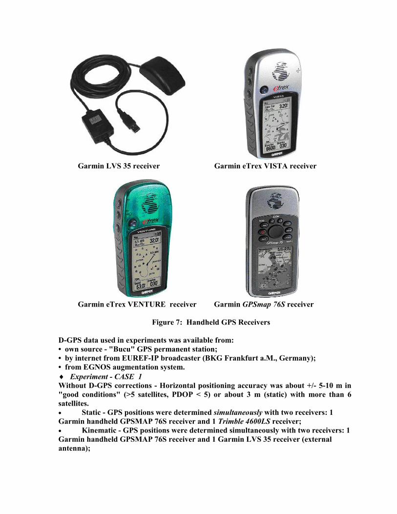
Garmin LVS 35 receiver Garmin eTrex VISTA receiver
Garmin eTrex VENTURE receiver Garmin GPSmap 76S receiver
Figure 7: Handheld GPS Receivers
D-GPS data used in experiments was available from:• own source - "Bucu" GPS permanent station;• by internet from EUREF-IP broadcaster (BKG Frankfurt a.M., Germany);• from EGNOS augmentation system.� Experiment - CASE 1Without D-GPS corrections - Horizontal positioning accuracy was about +/- 5-10 m in"good conditions" (>5 satellites, PDOP < 5) or about 3 m (static) with more than 6satellites.� Static - GPS positions were determined simultaneously with two receivers: 1Garmin handheld GPSMAP 76S receiver and 1 Trimble 4600LS receiver;� Kinematic - GPS positions were determined simultaneously with two receivers: 1Garmin handheld GPSMAP 76S receiver and 1 Garmin LVS 35 receiver (externalantenna);

Fig.8 a) Satellite sky - view in "good conditions" Fig.8b) SNR plot in "good conditions"
Figure 9: Kinematic tests with GPSMAP 76S and Garmin 35 LVS receivers

� Experiment - CASE 2With D-GPS corrections from EGNOS - horizontal positioning accuracy obtained wasabout 2-4 m static and 3-6 m kinematic;Navigation (kinematic) tests were performed with RTCM input from EGNOS andNMEA output from handheld GPS receiver. The practical aspects derived from thisexperiment conclude that:� not all satellites in view received EGNOS corrections;� EGNOS signals most difficult to acquire in urban canyons (as Bucharest) or forests;� EGNOS signals most difficult to acquire in Romania due to EGNOS coverage
(Romania situated at Eastern EGNOS border);� EGNOS satellites contacted in Romania at low elevation - ID 44 - contacted all the
time at less than 40 degrees elevation.
� Experiment - CASE 3In this case D-GPS corrections were collected directly from ground stations (EUREF-IP, EGNOS) horizontal positioning accuracy obtained was about 0.5-2 m static;D-GPS data collected by internet from ground stations:BUCU – Bucharest - EUREF:[a) direct from the station; b) via Frankfurt a.M.], SOFI – Sofia (Bulgaria) - EGNOSSZEK – Szekesfehervar (Hungary) – EUREF, PENC - Penc (Hungary) – EUREF,FFMJ – Frankfurt (Germany) – EUREF, HERT - Hailsham (UK) – EUREF.
Fig.10 D-GPS Tests with RTCM corrections directly from ground stations
An important factor studied was the "age" of D-GNSS data. On this topic two situationswere considered: test with D-GPS corrections from "Bucu" to USER and test with D-GPS corrections from "Bucu">Frankfurt>"Bucu" to USER;From these experiments was observed an influence in horizontal positioning accuracyless than 0.2m. In the same time it is possible that satellite constellation can differ fromBroadcaster to USER if long distance between.

5. Conclusions.
Today D-GNSS technology can be introduced for monitor/navigation positioning withaccuracy of about 1-5m, static or kinematic.It is necessary to manage all possible error sources as: data transfer delay, D-GNSSequipments, D-GNSS data sources, EGNOS coverage et al.It is necessary to establish in Romania a D-GNSS service based on GNSS permanentstations already installed.
Acknowledgements: I express my thanks to RQA IMPEX COMPANY SRL – Bucharest, Garminrepresentance in Romania who kindky let at our disposal Garmin (eTrex and GPSMAP 76S)receivers during tests.
References
G. Weber, H. Gebhard, D. Dettmering, Networked Transport of RTCM via InternetProtocol (Ntrip), Presentation, IAG, Saporro, Japan, 2003-7-02, RTCM Paper 167-203/SC104-314;G. Weber, D. Dettmering, H. Gebhard, Real Time GNSS via Internet Protocol Status &Standardization, Federal Agency for Cartography and Geodesy, BKG, Frankfurt,CGSIC 43rd Arlington, Virginia, March 10-11, 2004;T.Rus, GNSS Differential Positioning Technologies (in Romanian), Conference – GroupG2-Digital Maps, January 16, 2004, Giurgiu, Romania;T.Rus, J. Neuner, GNSS Applications in Technological and Natural Hazard Areas,Regional Workshop on the Use of Space Technology for Disaster Management forEurope, 19-23 May 2003, Braşov, Romania;*** SISNeT Technical Note, SISNeT brochure, June 2002*** SISNeT Technical Note, SISNeT User Interface Document Issue 2.1, June 2002.
EUREF-IP Real-Time Projecthttp://www.epncb.oma.be/projects/euref_IP/euref_IP.htmlAvalability in Europehttp://igs.ifag.de/root_ftp/misc/ntrip//mapsNetworked Transport of RTCM via Internet Protocol (Ntrip) Documentationhttp://igs.ifag.de/root_ftp/software/NtripDocumentation.zipNtrip Software Downloadshttp://igs.ifag.de/index_ntrip_cast.htmEUREF-IP Real-Time Project at Bucu EPN stationhttp://193.231.4.70:8888/EUREF_IP.htmlD-GNSS Tests at Bucu EPN stationhttp://193.231.4.70:8888/Galileo/corectii_D_GNSS_5.htmlhttp://193.231.4.70:8888/Galileo/corectii_D_GNSS_6.htmlESA-Navigation-Egnos web pagehttp://esamultimedia.esa.int/docs/egnos/estb/egnos_pro.htmESA-SISNeT web pagehttp://esamultimedia.esa.int/docs/egnos/estb/sisnet/about_sisnet.htm