Embed Size (px)
Citation preview
Enterprise GIS Strategic Plan 2012-2015
County of Los Angeles
Enterprise Geographic Information Systems (eGIS)
2012-2015 Strategic Plan
January 2013
Enterprise GIS Strategic Plan 2012-2015
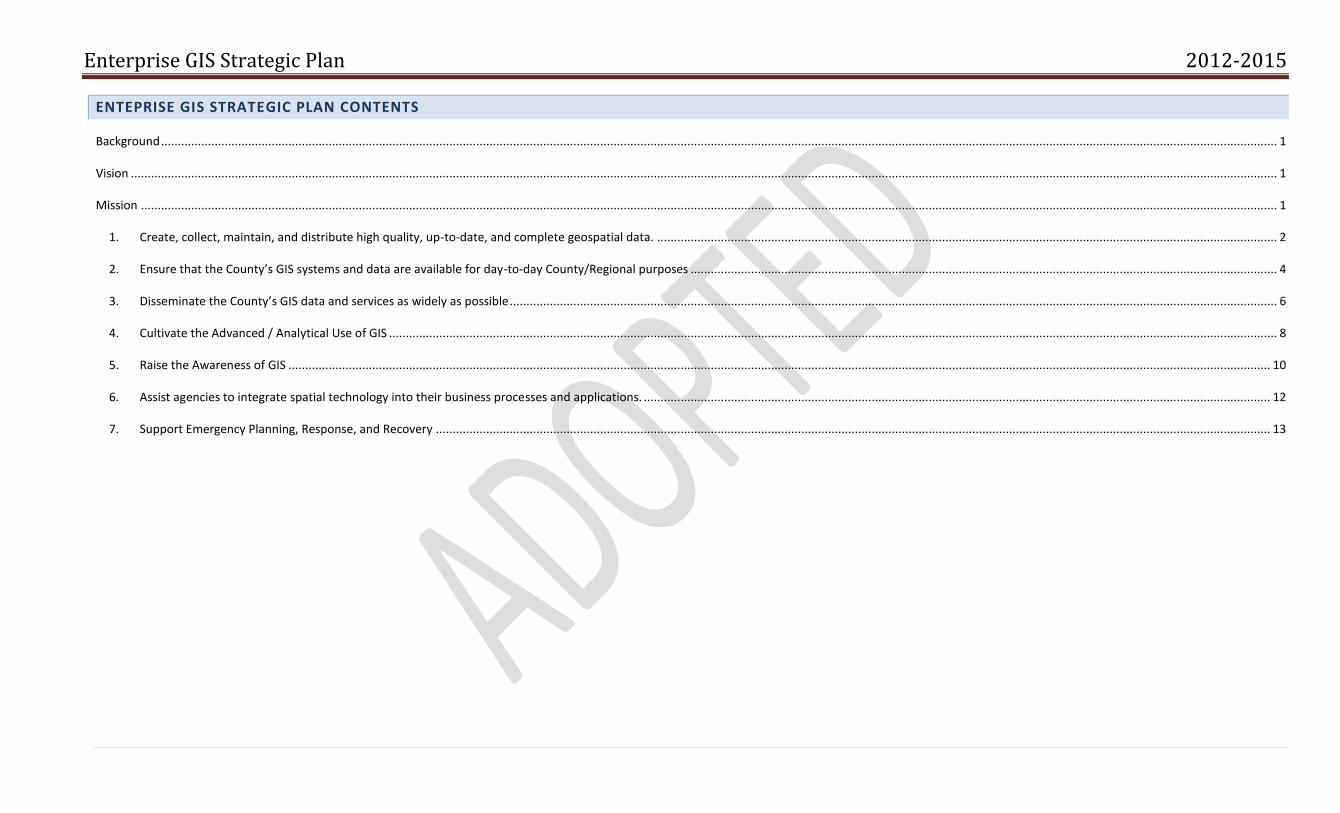
ENTEPRISE GIS STRATEGIC PLAN CONTENTS
Background ............................................................................................................................................................................................................................................................................................................................................. 1
Vision ...................................................................................................................................................................................................................................................................................................................................................... 1
Mission ................................................................................................................................................................................................................................................................................................................................................... 1
1. Create, collect, maintain, and distribute high quality, up-to-date, and complete geospatial data. ......................................................................................................................................................................................... 2
2. Ensure that the County’s GIS systems and data are available for day-to-day County/Regional purposes ............................................................................................................................................................................... 4
3. Disseminate the County’s GIS data and services as widely as possible ..................................................................................................................................................................................................................................... 6
4. Cultivate the Advanced / Analytical Use of GIS ......................................................................................................................................................................................................................................................................... 8
5. Raise the Awareness of GIS ..................................................................................................................................................................................................................................................................................................... 10
6. Assist agencies to integrate spatial technology into their business processes and applications. ........................................................................................................................................................................................... 12
7. Support Emergency Planning, Response, and Recovery ......................................................................................................................................................................................................................................................... 13
1 | P a g e
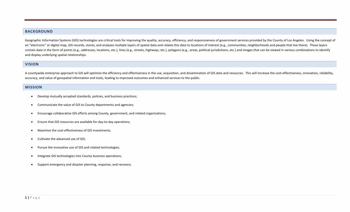
BACKGROUND
Geographic Information Systems (GIS) technologies are critical tools for improving the quality, accuracy, efficiency, and responsiveness of government services provided by the County of Los Angeles. Using the concept of
an “electronic” or digital map, GIS records, stores, and analyzes multiple layers of spatial data and relates this data to locations of interest (e.g., communities, neighborhoods and people that live there). These layers
contain data in the form of points (e.g., addresses, locations, etc.), lines (e.g., streets, highways, etc.), polygons (e.g., areas, political jurisdictions, etc.) and images that can be viewed in various combinations to identify
and display underlying spatial relationships.
VISION
A countywide enterprise approach to GIS will optimize the efficiency and effectiveness in the use, acquisition, and dissemination of GIS data and resources. This will increase the cost-effectiveness, innovation, reliability,
accuracy, and value of geospatial information and tools, leading to improved outcomes and enhanced services to the public.
MISSION
Develop mutually accepted standards, policies, and business practices;
Communicate the value of GIS to County departments and agencies;
Encourage collaborative GIS efforts among County, government, and related organizations;
Ensure that GIS resources are available for day-to-day operations;
Maximize the cost-effectiveness of GIS investments;
Cultivate the advanced use of GIS;
Pursue the innovative use of GIS and related technologies;
Integrate GIS technologies into County business operations;
Support emergency and disaster planning, response, and recovery.
2 | P a g e
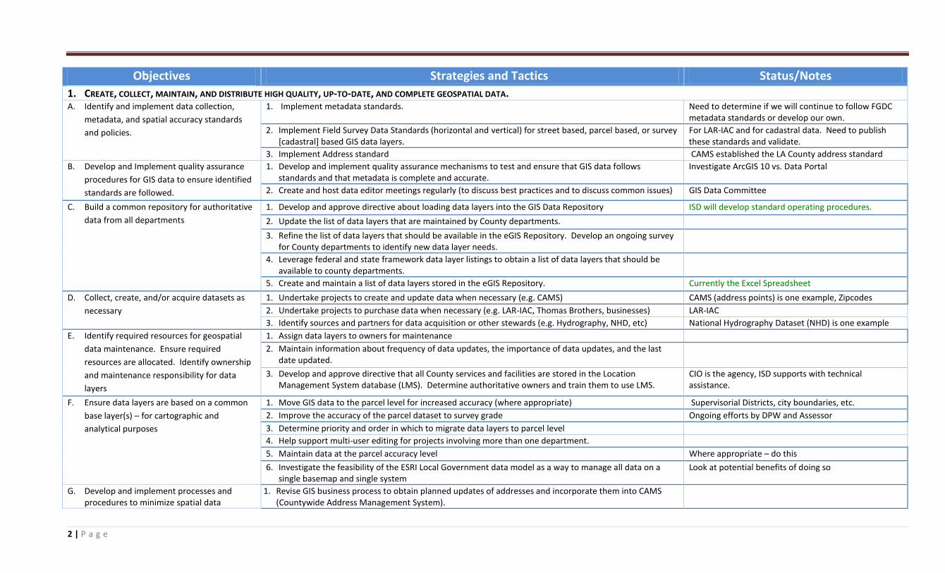
Objectives Strategies and Tactics Status/Notes
1. CREATE, COLLECT, MAINTAIN, AND DISTRIBUTE HIGH QUALITY, UP-TO-DATE, AND COMPLETE GEOSPATIAL DATA. A. Identify and implement data collection,
metadata, and spatial accuracy standards
and policies.
1. Implement metadata standards. Need to determine if we will continue to follow FGDC metadata standards or develop our own.
2. Implement Field Survey Data Standards (horizontal and vertical) for street based, parcel based, or survey [cadastral] based GIS data layers.
For LAR-IAC and for cadastral data. Need to publish these standards and validate.
3. Implement Address standard CAMS established the LA County address standard
B. Develop and Implement quality assurance
procedures for GIS data to ensure identified
standards are followed.
1. Develop and implement quality assurance mechanisms to test and ensure that GIS data follows standards and that metadata is complete and accurate.
Investigate ArcGIS 10 vs. Data Portal
2. Create and host data editor meetings regularly (to discuss best practices and to discuss common issues) GIS Data Committee
C. Build a common repository for authoritative
data from all departments
1. Develop and approve directive about loading data layers into the GIS Data Repository ISD will develop standard operating procedures.
2. Update the list of data layers that are maintained by County departments.
3. Refine the list of data layers that should be available in the eGIS Repository. Develop an ongoing survey for County departments to identify new data layer needs.
4. Leverage federal and state framework data layer listings to obtain a list of data layers that should be available to county departments.
5. Create and maintain a list of data layers stored in the eGIS Repository. Currently the Excel Spreadsheet
D. Collect, create, and/or acquire datasets as
necessary
1. Undertake projects to create and update data when necessary (e.g. CAMS) CAMS (address points) is one example, Zipcodes
2. Undertake projects to purchase data when necessary (e.g. LAR-IAC, Thomas Brothers, businesses) LAR-IAC
3. Identify sources and partners for data acquisition or other stewards (e.g. Hydrography, NHD, etc) National Hydrography Dataset (NHD) is one example
E. Identify required resources for geospatial
data maintenance. Ensure required
resources are allocated. Identify ownership
and maintenance responsibility for data
layers
1. Assign data layers to owners for maintenance
2. Maintain information about frequency of data updates, the importance of data updates, and the last date updated.
3. Develop and approve directive that all County services and facilities are stored in the Location Management System database (LMS). Determine authoritative owners and train them to use LMS.
CIO is the agency, ISD supports with technical assistance.
F. Ensure data layers are based on a common
base layer(s) – for cartographic and
analytical purposes
1. Move GIS data to the parcel level for increased accuracy (where appropriate) Supervisorial Districts, city boundaries, etc.
2. Improve the accuracy of the parcel dataset to survey grade Ongoing efforts by DPW and Assessor
3. Determine priority and order in which to migrate data layers to parcel level
4. Help support multi-user editing for projects involving more than one department.
5. Maintain data at the parcel accuracy level Where appropriate – do this
6. Investigate the feasibility of the ESRI Local Government data model as a way to manage all data on a single basemap and single system
Look at potential benefits of doing so
G. Develop and implement processes and procedures to minimize spatial data
1. Revise GIS business process to obtain planned updates of addresses and incorporate them into CAMS (Countywide Address Management System).
3 | P a g e
Objectives Strategies and Tactics Status/Notes
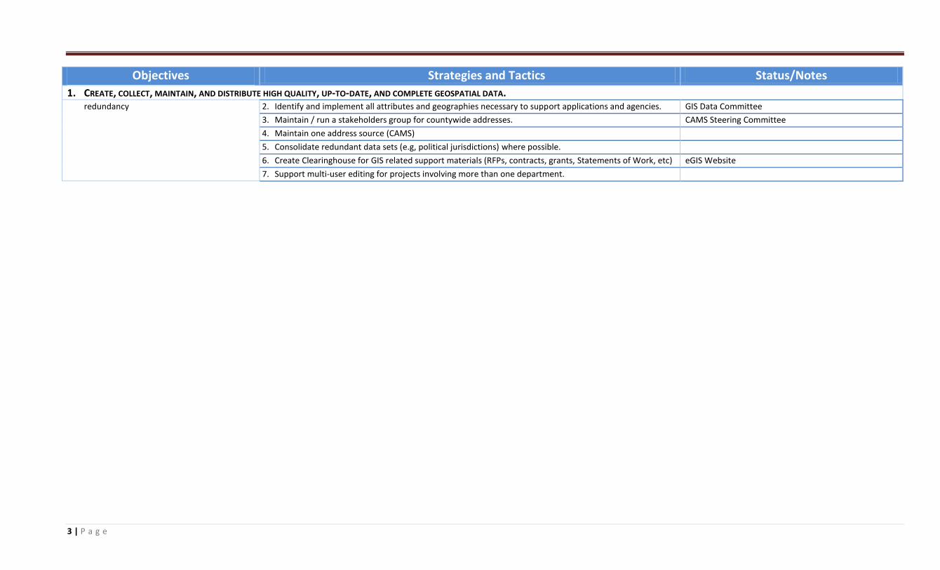
1. CREATE, COLLECT, MAINTAIN, AND DISTRIBUTE HIGH QUALITY, UP-TO-DATE, AND COMPLETE GEOSPATIAL DATA. redundancy 2. Identify and implement all attributes and geographies necessary to support applications and agencies. GIS Data Committee
3. Maintain / run a stakeholders group for countywide addresses. CAMS Steering Committee
4. Maintain one address source (CAMS)
5. Consolidate redundant data sets (e.g, political jurisdictions) where possible.
6. Create Clearinghouse for GIS related support materials (RFPs, contracts, grants, Statements of Work, etc) eGIS Website
7. Support multi-user editing for projects involving more than one department.
4 | P a g e
Objectives Strategies and Tactics Status/Notes
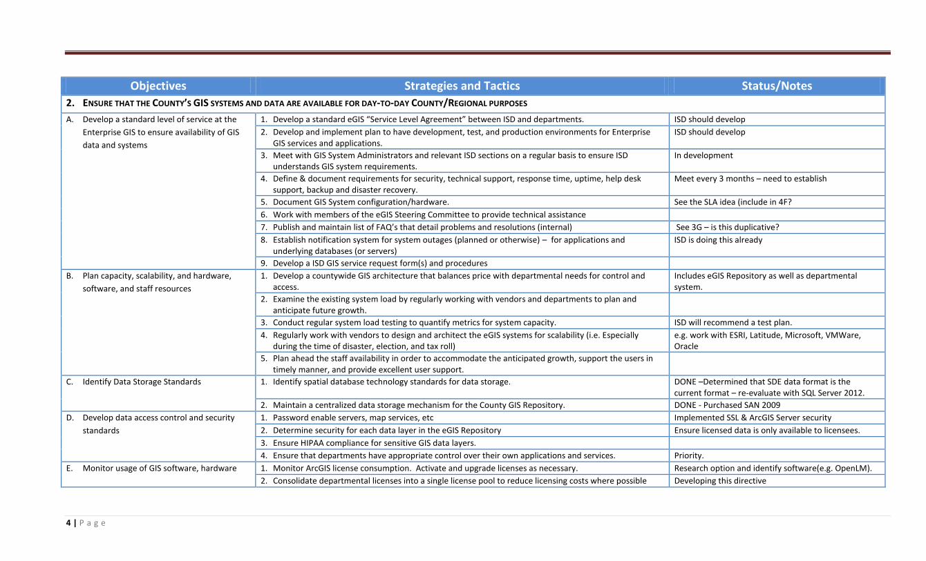
2. ENSURE THAT THE COUNTY’S GIS SYSTEMS AND DATA ARE AVAILABLE FOR DAY-TO-DAY COUNTY/REGIONAL PURPOSES
A. Develop a standard level of service at the
Enterprise GIS to ensure availability of GIS
data and systems
1. Develop a standard eGIS “Service Level Agreement” between ISD and departments. ISD should develop
2. Develop and implement plan to have development, test, and production environments for Enterprise GIS services and applications.
ISD should develop
3. Meet with GIS System Administrators and relevant ISD sections on a regular basis to ensure ISD understands GIS system requirements.
In development
4. Define & document requirements for security, technical support, response time, uptime, help desk support, backup and disaster recovery.
Meet every 3 months – need to establish
5. Document GIS System configuration/hardware. See the SLA idea (include in 4F?
6. Work with members of the eGIS Steering Committee to provide technical assistance
7. Publish and maintain list of FAQ’s that detail problems and resolutions (internal) See 3G – is this duplicative?
8. Establish notification system for system outages (planned or otherwise) – for applications and underlying databases (or servers)
ISD is doing this already
9. Develop a ISD GIS service request form(s) and procedures
B. Plan capacity, scalability, and hardware,
software, and staff resources
1. Develop a countywide GIS architecture that balances price with departmental needs for control and access.
Includes eGIS Repository as well as departmental system.
2. Examine the existing system load by regularly working with vendors and departments to plan and anticipate future growth.
3. Conduct regular system load testing to quantify metrics for system capacity. ISD will recommend a test plan.
4. Regularly work with vendors to design and architect the eGIS systems for scalability (i.e. Especially during the time of disaster, election, and tax roll)
e.g. work with ESRI, Latitude, Microsoft, VMWare, Oracle
5. Plan ahead the staff availability in order to accommodate the anticipated growth, support the users in timely manner, and provide excellent user support.
C. Identify Data Storage Standards 1. Identify spatial database technology standards for data storage. DONE –Determined that SDE data format is the current format – re-evaluate with SQL Server 2012.
2. Maintain a centralized data storage mechanism for the County GIS Repository. DONE - Purchased SAN 2009
D. Develop data access control and security
standards
1. Password enable servers, map services, etc Implemented SSL & ArcGIS Server security
2. Determine security for each data layer in the eGIS Repository Ensure licensed data is only available to licensees.
3. Ensure HIPAA compliance for sensitive GIS data layers.
4. Ensure that departments have appropriate control over their own applications and services. Priority.
E. Monitor usage of GIS software, hardware 1. Monitor ArcGIS license consumption. Activate and upgrade licenses as necessary. Research option and identify software(e.g. OpenLM).
2. Consolidate departmental licenses into a single license pool to reduce licensing costs where possible Developing this directive
5 | P a g e
Objectives Strategies and Tactics Status/Notes
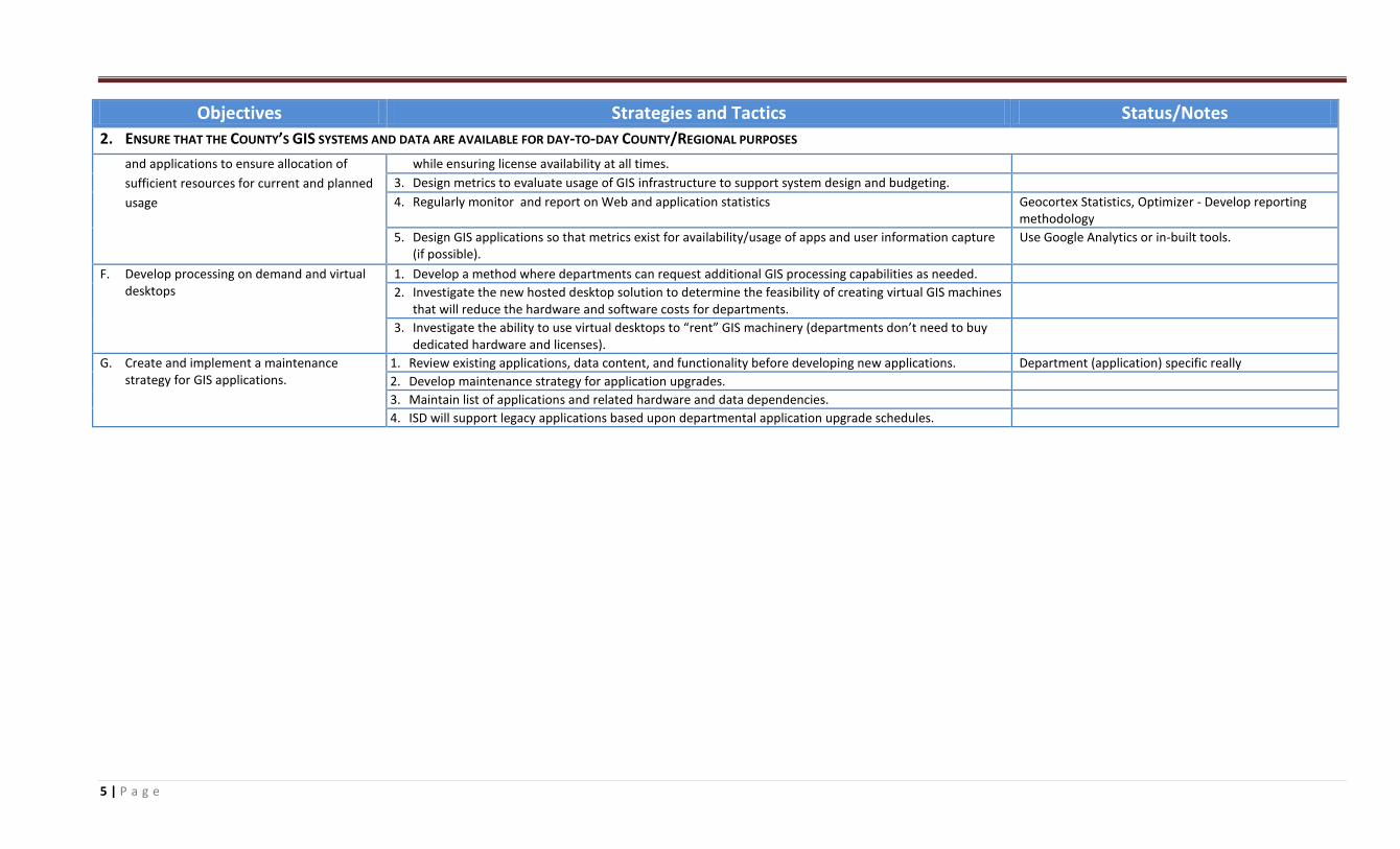
2. ENSURE THAT THE COUNTY’S GIS SYSTEMS AND DATA ARE AVAILABLE FOR DAY-TO-DAY COUNTY/REGIONAL PURPOSES
and applications to ensure allocation of
sufficient resources for current and planned
usage
while ensuring license availability at all times.
3. Design metrics to evaluate usage of GIS infrastructure to support system design and budgeting.
4. Regularly monitor and report on Web and application statistics Geocortex Statistics, Optimizer - Develop reporting methodology
5. Design GIS applications so that metrics exist for availability/usage of apps and user information capture (if possible).
Use Google Analytics or in-built tools.
F. Develop processing on demand and virtual desktops
1. Develop a method where departments can request additional GIS processing capabilities as needed.
2. Investigate the new hosted desktop solution to determine the feasibility of creating virtual GIS machines that will reduce the hardware and software costs for departments.
3. Investigate the ability to use virtual desktops to “rent” GIS machinery (departments don’t need to buy dedicated hardware and licenses).
G. Create and implement a maintenance strategy for GIS applications.
1. Review existing applications, data content, and functionality before developing new applications. Department (application) specific really
2. Develop maintenance strategy for application upgrades.
3. Maintain list of applications and related hardware and data dependencies.
4. ISD will support legacy applications based upon departmental application upgrade schedules.
6 | P a g e
Objectives Strategies and Tactics Status/Notes 3. DISSEMINATE THE COUNTY’S GIS DATA AND SERVICES AS WIDELY AS POSSIBLE
A. Distribute County GIS data as widely as
possible to ensure reduced duplication of
effort
1. Create a central web-based location where GIS data can be made available for download. DONE – LA County GIS Data Portal (Data Portal)
2. Where possible, make data available for free. Continue to build common repository for authoritative data from all departments
Ongoing efforts – the ‘democratization’ of data
3. Where possible, use publicly available information (e.g. Tiger data instead of Thomas Bros., for example)
4. Establish procedures for data dissemination and create disclaimer language for GIS data downloads.
B. Identify GIS development standards and
best practices to support dissemination of
LA County GIS data.
1. Develop GIS web services and applications utilizing standards where relevant. ESRI REST endpoints, WMS, WFS standards (leveraging ESRI technology)
2. Sign countywide licenses for commercial mapping services to reduce costs where possible. DONE – signed agreements with Google, and Bing
3. Develop a mobile GIS development standard, and ensure platform independence where possible.
4. Identify a web GIS development standard (flex vs. Silverlight vs. HTML5) where possible. Geocortex Essentials and IMF
5. Develop best practices for application development methodologies and configurations. Reconvene the Application Developer Working Group
C. Identify mechanisms to view and access GIS
Data
1. Identify Desktop GIS, Web-based GIS, Mobile GIS, Developer APIs and frameworks (SDKs) DONE - ESRI is an ad-hoc county standard
2. Investigate the feasibility of using free and Open Source GIS server and distribution software (e.g. ) qGIS, gvSIG, TileMapper, OpenGeo.
3. Develop mechanism to access GIS files (internal and external) DONE – GIS Data Portal
4. Develop and document Web Services that provide access to GIS capabilities. UDDI? Replaced by LA County GIS Data Portal?
5. Create GeoRSS feeds of County GIS data for wider distribution. DONE – LA County GIS Data Portal
6. Make sure the system architecture supports internal and external applications. DONE – eGIS has intranet and internet servers
7. Establish a repository of documents, resources, and guides that assist departmental GIS managers with leveraging eGIS resources.
eGIS has a page but needs to be updated.
D. Establish LA county Enterprise GIS website 1. Create the http://gis.lacounty.gov/egis web site to provide a central entry for county GIS DONE -The eGIS Website handles this.
2. Implement access control on the portal. DONE – Part of the LA County GIS Data Portal
3. Link(s) to GIS sites and projects of all County departments eGIS Website
4. Link(s) to training - resources for County GIS users and professionals eGIS Website
5. Link(s) to data and software download locations. eGIS Website link to the LA County GIS Data Portal
E. Ensure cost effectiveness of all GIS usage
and solutions (e.g. - obtain least expensive
license)
1. Leverage collaborative purchasing agreements where possible to achieve cost savings.
2. Implement web-based GIS toolsets for Countywide use. Latitude Geographics products.
3. Complete ESRI Master Purchase Agreement to reduce software purchasing costs. DONE - ESRI MPA
4. Upgrade unused licenses instead of purchasing new licenses. Ongoing
5. Investigate the feasibility of an ESRI Enterprise License Agreement. Will be done after License Consolidation
F. Where possible, make County GIS resources 1. Develop a strategy for making GIS services available to external agencies where possible. See 4H – need to determine support model – but right
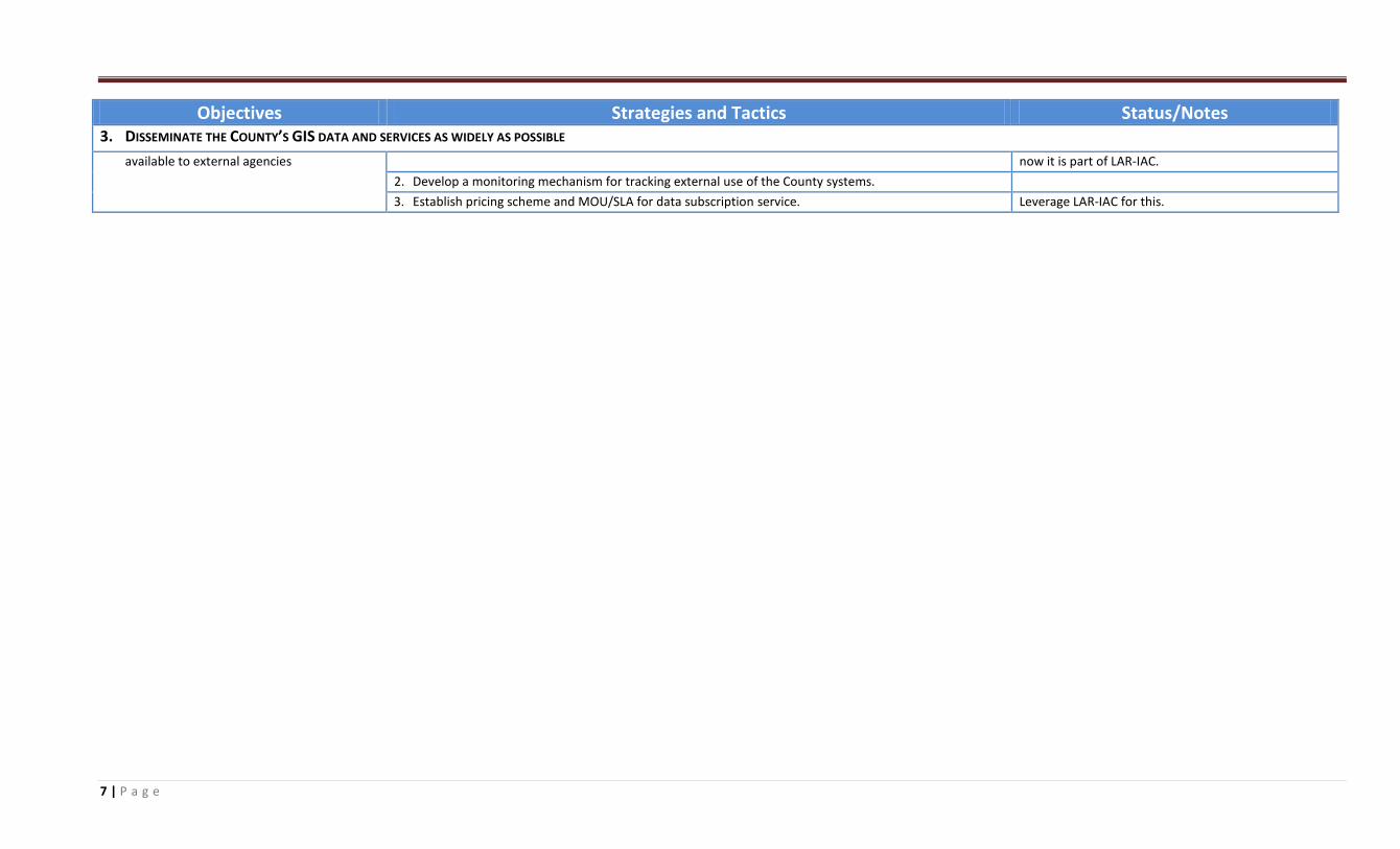
7 | P a g e
Objectives Strategies and Tactics Status/Notes 3. DISSEMINATE THE COUNTY’S GIS DATA AND SERVICES AS WIDELY AS POSSIBLE
available to external agencies now it is part of LAR-IAC.
2. Develop a monitoring mechanism for tracking external use of the County systems.
3. Establish pricing scheme and MOU/SLA for data subscription service. Leverage LAR-IAC for this.
8 | P a g e
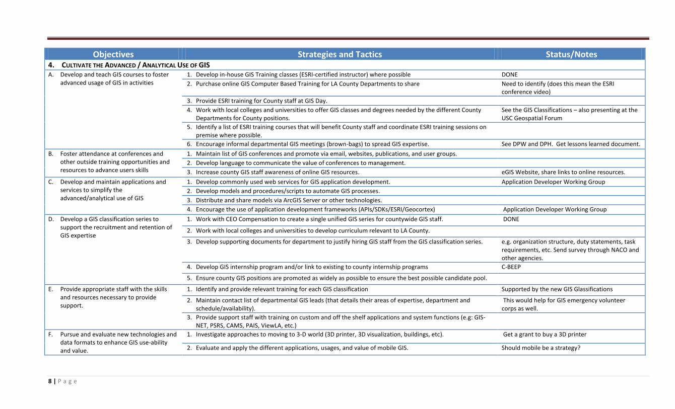
Objectives Strategies and Tactics Status/Notes 4. CULTIVATE THE ADVANCED / ANALYTICAL USE OF GIS A. Develop and teach GIS courses to foster
advanced usage of GIS in activities 1. Develop in-house GIS Training classes (ESRI-certified instructor) where possible DONE
2. Purchase online GIS Computer Based Training for LA County Departments to share Need to identify (does this mean the ESRI conference video)
3. Provide ESRI training for County staff at GIS Day.
4. Work with local colleges and universities to offer GIS classes and degrees needed by the different County Departments for County positions.
See the GIS Classifications – also presenting at the USC Geospatial Forum
5. Identify a list of ESRI training courses that will benefit County staff and coordinate ESRI training sessions on premise where possible.
6. Encourage informal departmental GIS meetings (brown-bags) to spread GIS expertise. See DPW and DPH. Get lessons learned document.
B. Foster attendance at conferences and other outside training opportunities and resources to advance users skills
1. Maintain list of GIS conferences and promote via email, websites, publications, and user groups.
2. Develop language to communicate the value of conferences to management.
3. Increase county GIS staff awareness of online GIS resources. eGIS Website, share links to online resources.
C. Develop and maintain applications and services to simplify the advanced/analytical use of GIS
1. Develop commonly used web services for GIS application development. Application Developer Working Group
2. Develop models and procedures/scripts to automate GIS processes.
3. Distribute and share models via ArcGIS Server or other technologies.
4. Encourage the use of application development frameworks (APIs/SDKs/ESRI/Geocortex) Application Developer Working Group
D. Develop a GIS classification series to support the recruitment and retention of GIS expertise
1. Work with CEO Compensation to create a single unified GIS series for countywide GIS staff. DONE
2. Work with local colleges and universities to develop curriculum relevant to LA County.
3. Develop supporting documents for department to justify hiring GIS staff from the GIS classification series. e.g. organization structure, duty statements, task requirements, etc. Send survey through NACO and other agencies.
4. Develop GIS internship program and/or link to existing to county internship programs C-BEEP
5. Ensure county GIS positions are promoted as widely as possible to ensure the best possible candidate pool.
E. Provide appropriate staff with the skills and resources necessary to provide support.
1. Identify and provide relevant training for each GIS classification Supported by the new GIS Glassifications
2. Maintain contact list of departmental GIS leads (that details their areas of expertise, department and schedule/availability).
This would help for GIS emergency volunteer corps as well.
3. Provide support staff with training on custom and off the shelf applications and system functions (e.g: GIS-NET, PSRS, CAMS, PAIS, ViewLA, etc.)
F. Pursue and evaluate new technologies and data formats to enhance GIS use-ability and value.
1. Investigate approaches to moving to 3-D world (3D printer, 3D visualization, buildings, etc). Get a grant to buy a 3D printer
2. Evaluate and apply the different applications, usages, and value of mobile GIS. Should mobile be a strategy?
9 | P a g e
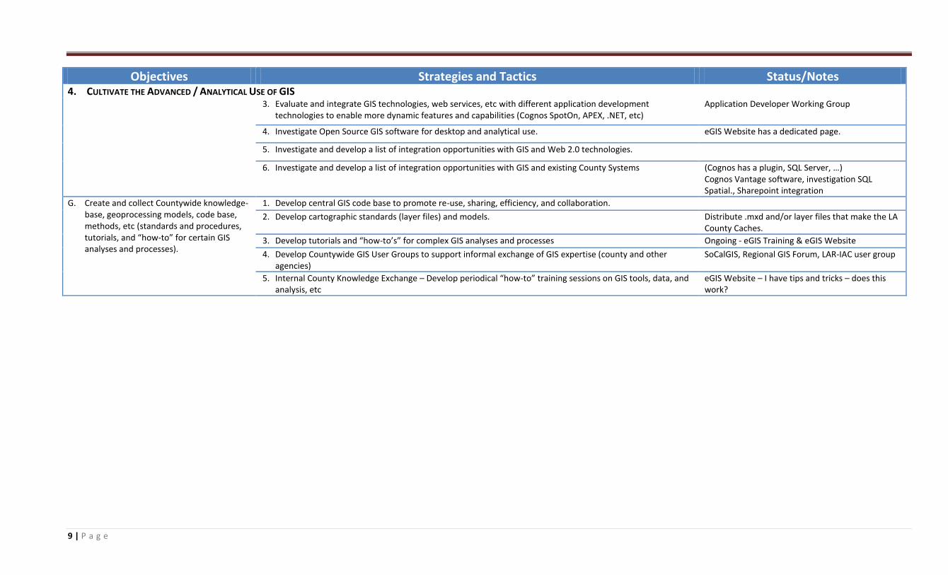
Objectives Strategies and Tactics Status/Notes 4. CULTIVATE THE ADVANCED / ANALYTICAL USE OF GIS
3. Evaluate and integrate GIS technologies, web services, etc with different application development technologies to enable more dynamic features and capabilities (Cognos SpotOn, APEX, .NET, etc)
Application Developer Working Group
4. Investigate Open Source GIS software for desktop and analytical use. eGIS Website has a dedicated page.
5. Investigate and develop a list of integration opportunities with GIS and Web 2.0 technologies.
6. Investigate and develop a list of integration opportunities with GIS and existing County Systems (Cognos has a plugin, SQL Server, …) Cognos Vantage software, investigation SQL Spatial., Sharepoint integration
G. Create and collect Countywide knowledge-base, geoprocessing models, code base, methods, etc (standards and procedures, tutorials, and “how-to” for certain GIS analyses and processes).
1. Develop central GIS code base to promote re-use, sharing, efficiency, and collaboration.
2. Develop cartographic standards (layer files) and models. Distribute .mxd and/or layer files that make the LA County Caches.
3. Develop tutorials and “how-to’s” for complex GIS analyses and processes Ongoing - eGIS Training & eGIS Website
4. Develop Countywide GIS User Groups to support informal exchange of GIS expertise (county and other agencies)
SoCalGIS, Regional GIS Forum, LAR-IAC user group
5. Internal County Knowledge Exchange – Develop periodical “how-to” training sessions on GIS tools, data, and analysis, etc
eGIS Website – I have tips and tricks – does this work?
10 | P a g e
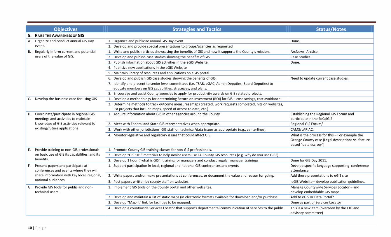
Objectives Strategies and Tactics Status/Notes 5. RAISE THE AWARENESS OF GIS A. Organize and conduct annual GIS Day
event. 1. Organize and publicize annual GIS Day event. Done.
2. Develop and provide special presentations to groups/agencies as requested
B. Regularly inform current and potential users of the value of GIS.
1. Write and publish articles showcasing the benefits of GIS and how it supports the County’s mission. ArcNews, ArcUser
2. Develop and publish case studies showing the benefits of GIS. Case Studies!
3. Publish information about GIS activities in the eGIS Website. Done.
4. Publicize new applications in the eGIS Website
5. Maintain library of resources and applications on eGIS portal.
6. Develop and publish GIS case studies showing the benefits of GIS. Need to update current case studies.
7. Identify and present to senior level committees (i.e. TSAB, eGAC, Admin Deputies, Board Deputies) to educate members on GIS capabilities, strategies, and plans.
8. Encourage and assist County agencies to apply for productivity awards on GIS related projects.
C. Develop the business case for using GIS 1. Develop a methodology for determining Return on Investment (ROI) for GIS – cost savings, cost avoidance.
2. Determine methods to track outcome measures (maps created, work requests completed, hits on websites, list projects that include maps, speed of access to data, etc.)
D. Coordinate/participate in regional GIS meetings and activities to maintain knowledge of GIS activities relevant to existing/future applications
1. Acquire information about GIS in other agencies around the County Establishing the Regional GIS Forum and participate in the SoCalGIS
2. Meet with Federal and State GIS representatives when appropriate. Regional GIS Forum/
3. Work with other jurisdictions’ GIS staff on technical/data issues as appropriate (e.g., centerlines). CAMS/LARIAC.
4. Monitor legislative and regulatory issues that could affect GIS. What is the process for this – For example the Orange County case (Legal descriptions vs. feature based “data escrow”)
E. Provide training to non-GIS professionals on basic use of GIS its capabilities, and its benefits.
1. Promote County GIS training classes for non-GIS professionals.
2. Develop “GIS 101” materials to help novice users use LA County GIS resources (e.g. why do you use GIS?)
3. Develop 1 hour (“what is GIS”) training for managers and conduct regular manager trainings Done for GIS Day 2011.
F. Present papers and participate at conferences and events where they will share information with key local, regional, national audiences
1. Support participation in local, regional and national GIS conferences and events Develop specific language supporting conference attendance
2. Write papers and/or make presentations at conferences, or document the value and reason for going. Add these presentations to eGIS site
3. Post papers written by county staff on websites. eGIS Website – develop publication guidelines.
G. Provide GIS tools for public and non-technical users.
1. Implement GIS tools on the County portal and other web sites. Manage Countywide Services Locator – and develop embeddable GIS maps.
2. Develop and maintain a list of static maps (in electronic format) available for download and/or purchase. Add to eGIS or Data Portal?
3. Develop “Map-It” link for facilities to be mapped. Done as part of Services Locator
4. Develop a countywide Services Locator that supports departmental communication of services to the public. This is a new item (overseen by the CIO and advisory committee)
11 | P a g e
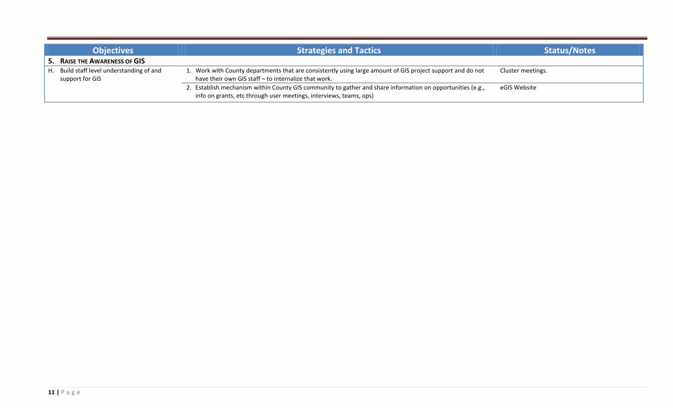
Objectives Strategies and Tactics Status/Notes 5. RAISE THE AWARENESS OF GIS H. Build staff level understanding of and
support for GIS 1. Work with County departments that are consistently using large amount of GIS project support and do not
have their own GIS staff – to internalize that work. Cluster meetings.
2. Establish mechanism within County GIS community to gather and share information on opportunities (e.g., info on grants, etc through user meetings, interviews, teams, ops)
eGIS Website
12 | P a g e
Objectives Strategies and Tactics Status/Notes
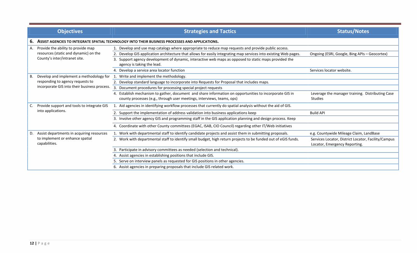
6. ASSIST AGENCIES TO INTEGRATE SPATIAL TECHNOLOGY INTO THEIR BUSINESS PROCESSES AND APPLICATIONS.
A. Provide the ability to provide map resources (static and dynamic) on the County’s inter/intranet site.
1. Develop and use map catalogs where appropriate to reduce map requests and provide public access.
2. Develop GIS application architecture that allows for easily integrating map services into existing Web pages. Ongoing (ESRI, Google, Bing APIs – Geocortex)
3. Support agency development of dynamic, interactive web maps as opposed to static maps provided the agency is taking the lead.
4. Develop a service area locator function Services locator website.
B. Develop and implement a methodology for responding to agency requests to incorporate GIS into their business process.
1. Write and implement the methodology.
2. Develop standard language to incorporate into Requests for Proposal that includes maps.
3. Document procedures for processing special project requests
4. Establish mechanism to gather, document and share information on opportunities to incorporate GIS in county processes (e.g., through user meetings, interviews, teams, ops)
Leverage the manager training. Distributing Case Studies
C. Provide support and tools to integrate GIS into applications.
1. Aid agencies in identifying workflow processes that currently do spatial analysis without the aid of GIS.
2. Support the implementation of address validation into business applications keep Build API
3. Involve other agency GIS and programming staff in the GIS application planning and design process. Keep
4. Coordinate with other County committees (EGAC, ISAB, CIO Council) regarding other IT/Web initiatives
D. Assist departments in acquiring resources to implement or enhance spatial capabilities.
1. Work with departmental staff to identify candidate projects and assist them in submitting proposals. e.g. Countywide Mileage Claim, LandBase
2. Work with departmental staff to identify small budget, high return projects to be funded out of eGIS funds. Services Locator, District Locator, Facility/Campus Locator, Emergency Reporting.
3. Participate in advisory committees as needed (selection and technical).
4. Assist agencies in establishing positions that include GIS.
5. Serve on interview panels as requested for GIS positions in other agencies.
6. Assist agencies in preparing proposals that include GIS related work.
13 | P a g e
Objectives Strategies and Tactics Status/Notes
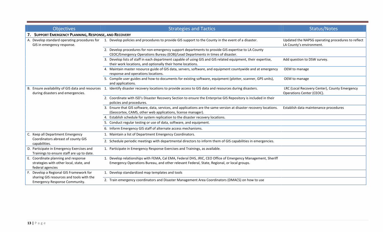
7. SUPPORT EMERGENCY PLANNING, RESPONSE, AND RECOVERY A. Develop standard operating procedures for
GIS in emergency response. 1. Develop policies and procedures to provide GIS support to the County in the event of a disaster. Updated the NAPSG operating procedures to reflect
LA County’s environment.
2. Develop procedures for non-emergency support departments to provide GIS expertise to LA County CEOC/Emergency Operations Bureau (EOB)/Lead Departments in times of disaster.
3. Develop lists of staff in each department capable of using GIS and GIS related equipment, their expertise, their work locations, and optionally their home locations.
Add question to DSW survey.
4. Maintain master resource guide of GIS data, servers, software, and equipment countywide and at emergency response and operations locations.
OEM to manage
5. Compile user guides and how-to documents for existing software, equipment (plotter, scanner, GPS units), and applications.
OEM to manage
B. Ensure availability of GIS data and resources during disasters and emergencies.
1. Identify disaster recovery locations to provide access to GIS data and resources during disasters. LRC (Local Recovery Center), County Emergency Operations Center (CEOC).
2. Coordinate with ISD’s Disaster Recovery Section to ensure the Enterprise GIS Repository is included in their policies and procedures.
3. Ensure that GIS software, data, services, and applications are the same version at disaster recovery locations. (Geocortex, CAMS, other web applications, license manager).
Establish data maintenance procedures
4. Establish schedule for system replication to the disaster recovery locations.
5. Conduct regular testing or use of data, software, and equipment.
6. Inform Emergency GIS staff of alternate access mechanisms.
C. Keep all Department Emergency Coordinators abreast of county GIS capabilities.
1. Maintain a list of Department Emergency Coordinators.
2. Schedule periodic meetings with departmental directors to inform them of GIS capabilities in emergencies.
D. Participate in Emergency Exercises and Trainings to ensure staff are up to date.
1. Participate in Emergency Response Exercises and Trainings, as available.
E. Coordinate planning and response strategies with other local, state, and federal agencies
1. Develop relationships with FEMA, Cal EMA, Federal DHS, JRIC, CEO Office of Emergency Management, Sheriff Emergency Operations Bureau, and other relevant Federal, State, Regional, or local groups.
F. Develop a Regional GIS Framework for sharing GIS resources and tools with the Emergency Response Community.
1. Develop standardized map templates and tools
2. Train emergency coordinators and Disaster Management Area Coordinators (DMACS) on how to use