Embed Size (px)
Citation preview

COUNTY OF LOS ANGELES, CALIFORNIA
Redistricting Supervisorial Districts - 2011 REPORT ON ADOPTED REDISTRICTING PLAN
PLAN TITLE: 2011 Board Adopted Plan
ORGANIZATION: County of Los Angeles Board of Supervisors
ADOPTED ON: September 27, 2011
Staff Report - 2011 Board Adopted Plan - September 27, 2011 Page 1 of 50

STAFF REPORT FOR 2011 BOARD ADOPTED PLAN TABLE OF CONTENTS
1. Communities & Total Population Reassigned (Moved) by This Plan (TABLE) ……………………... 3 2. Cities and Communities (MAP) .…………………………………………………………………………. 4 3. Adopted Boundaries (MAP) .……………………………………………………………………………. 5 4. Reassigned Areas (MAP) …………………………………………………………………………………. 6 5. Total Population Reassigned (Moved) by This Plan (TABLE) .…………………………………......... 7 6. Cities/Communities/Areas Reassigned by This Plan ……………………………………………......... 8-13 7. Total Population by Race/Ethnicity: DOJ Categories (TABLE) ……………………………………... 14 8. Distribution of Total Population among Districts by Race/Ethnicity DOJ Categories (CHART)……. 15 9. Voting Age Population by Race/Ethnicity: DOJ Categories (TABLE) ………………………………. 16 10. Distribution of Voting Age Population among Districts by Race/Ethnicity–DOJ Categories
(CHART) ……………………………………………………………………………………………………. 17
11. Total Population by Race/Ethnicity: L A County’s “Detailed” Categories (TABLE) ………………... 18 12. Voting Age Population by Race/Ethnicity: L A County’s “Detailed” Categories (TABLE) ..………… 19 13. Total Population by Race/Ethnicity: L A County’s “Inclusive” Categories (TABLE) ..………………. 20 14. Registered Voters by Race/Ethnicity (March 2011) (TABLE) ..……………………………………….. 21 15. Registered Voters by Political Party Affiliation (March 2011) (TABLE) .…………………………….. 22 16. Registered Voters by Gender (March 2011) (TABLE) ………………………………………………... 23 17. Registered Voters by Age (March 2011) (TABLE) …………………………………………………….. 24 18. Voting Age Population by Gender from American Community Survey (TABLE) ………………….. 25 19. Voting Age Citizen by Gender from American Community Survey (TABLE) ………………………. 26 20. Voting Age Citizen by DOJ Race/Ethnicity Categories from American Community Survey
(TABLE) ……………………………………………………………………………………………………... 27
21. Self-Reported Household Income from American Community Survey (TABLE) ………………….. 28 22. Self-Reported Estimated Value of Homes from American Community Survey (TABLE) ………… 29 23. Homeowners/Renters from American Community Survey (TABLE) ………………………………... 30 24. Communities Adopted District Assignments List: Countywide………………………………………. 31-35 25. Communities Adopted District Assignments List: By Adopted District …………………………... 36-40 26. County Facilities Adopted District Assignments List: Countywide …………………………………. 41-50
Staff Report - 2011 Board Adopted Plan - September 27, 2011 Page 2 of 50

Communities & Total Population Reassigned (Moved) by This Plan This redistricting plan reassigns the County's population per 2010 Census as shown below.
NOTES: 1. The data source for this table is the Census Bureau's 2010 Census: Public Law 94-171 Redistricting Data. 2. The column labeled "MOVED" indicates whether all "A" or only a portion "P" of the named community would be "MOVED" by this plan. 3. The column labeled "RESULT" indicates whether the move would result in having the named community be split "S" among or between multiple districts. 4. Or, the column labeled "RESULT" indicates whether the move would result in having the named community remain or become whole "W" within a single district. 5. The TOTAL POPULATION MOVED column depicts the number of persons who live in the reassigned area.
DISTRICT
MOVED
RESULT
DISTRICT
MOVED
RESULT
MOVED COMMUNITY Ref # BENCH-
MARK ADOPT-ED
TOTAL POPULATION
MOVED MOVED COMMUNITY Ref # BENCH-
MARK ADOPT-ED
TOTAL POPULATION
MOVED
1 5 1 295 P W Azusa 10 4 2 22,321 P S LACity - Westchester
2 5 1 35,065 A W Claremont 11 1 4 26 P S LACounty - Avocado Heights/Bassett
3 4 2 0 P W Hawthorne 12 5 1 422 P S LACounty - Claremont
4 4 1 0 P W Pico Rivera 13 5 1 822 P S LACounty - Covina Islands
5 1 4 16,223 A W Santa Fe Springs 14 1 2 23,153 P W LACounty - Florence/Firestone
6 5 1 106,047 P W West Covina 15 1 4 0 P W LACounty - Hacienda Heights
7 2 1 0 P S LACity - Miracle Mile 16 1 4 5,772 P S LACounty - Rowland Heights
8 3 1 15,468 P W LACity - Silverlake 17 1 4 17,525 P W LACounty - South Whittier
9 2 4 13,073 P S LACity - Westchester 18 1 4 21,392 P W LACounty - West Whittier/Los Nietos
277,604 Total Population Reassigned
Staff Report - 2011 Board Adopted Plan - September 27, 2011 Page 3 of 50

Location and scale of small maps are different than larger map
This map displays Los Angeles County’s cities and unincorporated areas. Cities appear in various colors; unincorporated areas are displayed in yellow. See accompanying Communities & District Assignments Lists for community names and their adopted and current (benchmark) district assignments.
LEGEND
Cities & Communities
REDISTRICTING PLAN 2011 Board Adopted Plan
This map displays the adopted plan’s Supervisorial District boundaries for the County of Los Angeles. Also shown are the cities and unincorporated areas.
REDISTRICTING 2011
Freeways
National Forest Boundary
City of Los Angeles
Unincorporated Areas
Benchmark District Boundary
Other Incorporated Cities
Board Adopted District Boundary
Staff Report - 2011 Board Adopted Plan - September 27, 2011 Page 4 of 50

Location and scale of small maps are different than larger map
Adopted Boundaries
REDISTRICTING PLAN
This map displays the adopted plan’s Supervisorial District boundaries for the County of Los Angeles. Also shown are areas that would be reassigned by this plan.
REDISTRICTING 2011
ADOPTED DISTRICT AREAS
Benchmark District Boundaries Red district numbers and red boundaries. Black boundaries cover red boundaries when same. Adopted District Boundaries Larger black italic numbers and black boundaries.
Supervisorial Districts
Freeways
1 (First)
2 (Second)
3 (Third)
4 (Fourth)
5 (Fifth)
2011 Board Adopted Plan
Staff Report - 2011 Board Adopted Plan - September 27, 2011 Page 5 of 50

Reassigned Areas
REDISTRICTING PLAN
This map displays the adopted plan’s Supervisorial District boundaries for the County of Los Angeles. Also shown are areas that are reassigned by this plan.
REDISTRICTING 2011
ADOPTED DISTRICT AREAS
Benchmark District Boundaries Red district numbers and red boundaries. Black boundaries cover red boundaries
when same. Adopted District Boundaries Larger black italic numbers and black
boundaries. Reassigned Areas Gray Redistricting Unit boundaries.
Supervisorial Districts
Freeways
1 (First)
2 (Second)
3 (Third)
4 (Fourth)
5 (Fifth)
Location and scale of small maps are different than larger map
2011 Board Adopted Plan
Staff Report - 2011 Board Adopted Plan - September 27, 2011 Page 6 of 50

1 2 3 4 5
1 - 15,468 - 142,651 158,119
2 23,153 - 22,321 - 45,474
3 - - - - -
4 60,938 13,073 - - 74,011
5 - - - - -
84,091 13,073 15,468 22,321 142,651 277,604
NOTES:1. The data source for this table is the Census Bureau's 2010 Census: Public Law 94-171 Redistricting Data.2. Each row depicts the number of persons who live in areas that would be assigned to the row's district.3. Each column depicts the number of persons who live in areas that would be assigned to the column's district.4. The shaded cells are not applicable: same "from" and "to" districts.5. The bottom row depicts the total population moved FROM each district, and the countywide total moved.6. The right-most column depicts the total population moved TO each district, and the countywide total moved.
Total Population Moved
Total Population Reassigned (Moved) by This PlanThis redistricting plan reassigns the County's population per 2010 Census as shown below.
Population Moved "From" District... Total Population Moved
Population Moved "To"
District…
Staff Report - 2011 Board Adopted Plan - September 27, 2011 Page 7 of 50

Cities/Communities/Areas Reassigned by This PlanThis redistricting plan reassigns the County's population per 2010 Census and registered voters, as of March 2011, as shown in this list.
DISTRICT REASSIGNMENTS (District-to-District) 1-to-2 1-to-4 1-to-4 1-to-4 1-to-4 1-to-4 1-to-4 1-to…
SANTA FE LACo - LACo - DISTRICT
LACo - SPRINGS LACo - HACIENDA LACo - SOUTH LACo - TOTALS
CITY / COMMUNITY / AREA REASSIGNED FLORENCE/ AVOCADO HEIGHTS ROWLAND WHITTIERW. WHITTIER/
FIRESTONE HEIGHTS/ HEIGHTS LOS NIETOSBASSETT
POPULATION (DOJ Categories) Total Population TOTALS: 23,153 16,223 26 0 5,772 17,525 21,392 84,091
Hispanic (All Races) 22,119 13,137 21 0 1,874 15,501 18,932 71,584Not Hispanic (NH) White (Single Race) 194 1,927 4 0 448 1,318 1,813 5,704NH African American or NH African American/White 720 321 0 0 74 137 163 1,415NH Asian or NH Asian/White 38 665 0 0 3,306 449 280 4,738NH American Indian or NH American Indian/White 23 91 1 0 15 34 107 271NH Pacific Islander or NH Pacific Islander/White 0 29 0 0 12 45 31 117NH Some Other Race or NH Some Other Race/White 49 31 0 0 2 13 48 143Other Multiple-Race (More than 1 minority race listed) 10 22 0 0 41 28 18 119
Voting Age Population TOTALS: 15,276 11,937 19 0 4,670 11,983 15,545 59,430
Hispanic (All Races) 14,506 9,339 14 0 1,337 10,279 13,436 48,911Not Hispanic (NH) White (Single Race) 133 1,671 4 0 397 1,141 1,601 4,947NH African American or NH African American/White 545 234 0 0 58 99 114 1,050NH Asian or NH Asian/White 38 569 0 0 2,821 373 237 4,038NH American Indian or NH American Indian/White 18 70 1 0 13 32 92 226NH Pacific Islander or NH Pacific Islander/White 0 21 0 0 9 34 22 86NH Some Other Race or NH Some Other Race/White 27 17 0 0 2 7 30 83Other Multiple-Race (More than 1 minority race listed) 9 16 0 0 33 18 13 89
Citizen Voting Age Population* TOTALS: 7,986 10,358 14 0 2,921 7,406 12,547 41,232
Hispanic (All Races) 7,294 7,834 9 0 761 5,819 10,565 32,282Not Hispanic (NH) White (Single Race) 87 1,647 4 0 386 1,132 1,572 4,828NH African American or NH African American/White 545 228 0 0 58 84 110 1,025NH Asian or NH Asian/White 32 536 0 0 1 661 289 159 2 677NH Asian or NH Asian/White 32 536 0 0 1,661 289 159 2,677NH American Indian or NH American Indian/White 7 64 1 0 13 29 87 201NH Pacific Islander or NH Pacific Islander/White 0 19 0 0 8 30 20 77NH Some Other Race or NH Some Other Race/White 12 14 0 0 1 5 22 54Other Multiple-Race (More than 1 minority race listed) 9 16 0 0 33 18 12 88
REGISTERED VOTERS Race / Ethnicity (Based on Surname) TOTALS: 5,806 8,926 7 2 1,925 6,038 10,432 33,136
Latino or Spanish 4,830 6,228 3 1 649 4,508 7,982 24,201Korean 2 57 0 0 81 8 9 157Japanese 5 23 0 0 11 15 27 81Chinese 13 42 0 0 442 17 14 528Indian 2 19 1 0 18 12 28 80Vietnamese 3 42 0 0 24 16 8 93Filipino 76 117 0 0 100 75 144 512Not Classified 875 2,398 3 1 600 1,387 2,220 7,484
Political Party Affiliation TOTALS: 5,806 8,926 7 2 1,925 6,038 10,432 33,136
Democrat 3,973 5,208 2 1 765 3,058 6,113 19,120Republican 542 1,975 2 1 429 1,600 2,187 6,736American Independent 94 176 0 0 44 111 223 648Libertarian 13 28 0 0 8 28 38 115Green 17 23 0 0 3 23 39 105Peace and Freedom 61 46 0 0 15 46 62 230Declined to State / No Party 1,079 1,440 3 0 645 1,130 1,709 6,006Some Other 27 30 0 0 16 42 61 176
NOTE: See explanatory notes at end of this reassignments list. Reassignment List Page 1Staff Report - 2011 Board Adopted Plan - September 27, 2011 Page 8 of 50

Cities/Communities/Areas Reassigned by This PlanThis redistricting plan reassigns the County's population per 2010 Census and registered voters, as of March 2011, as shown in this list.
DISTRICT REASSIGNMENTS (District-to-District)
CITY / COMMUNITY / AREA REASSIGNEDF
POPULATION (DOJ Categories) Total Population TOTALS:
Hispanic (All Races)Not Hispanic (NH) White (Single Race)NH African American or NH African American/WhiteNH Asian or NH Asian/WhiteNH American Indian or NH American Indian/WhiteNH Pacific Islander or NH Pacific Islander/WhiteNH Some Other Race or NH Some Other Race/WhiteOther Multiple-Race (More than 1 minority race listed)
Voting Age Population TOTALS:
Hispanic (All Races)Not Hispanic (NH) White (Single Race)NH African American or NH African American/WhiteNH Asian or NH Asian/WhiteNH American Indian or NH American Indian/WhiteNH Pacific Islander or NH Pacific Islander/WhiteNH Some Other Race or NH Some Other Race/WhiteOther Multiple-Race (More than 1 minority race listed)
Citizen Voting Age Population* TOTALS:
Hispanic (All Races)Not Hispanic (NH) White (Single Race)NH African American or NH African American/WhiteNH Asian or NH Asian/White
2-to-1 2-to-4 2-to…
DISTRICT
LACity - TOTALS
LACity - WESTCHESTER
MIRACLE MILE
0 13,073 13,0730 1,599 1,5990 8,244 8,2440 970 9700 1,945 1,9450 52 520 53 530 60 600 150 150
0 11,641 11,6410 1,331 1,3310 7,527 7,5270 832 8320 1,683 1,6830 48 480 50 500 48 480 122 122
0 10,818 10,8180 1,141 1,1410 7,152 7,1520 832 8320 1 465 1 465NH Asian or NH Asian/White
NH American Indian or NH American Indian/WhiteNH Pacific Islander or NH Pacific Islander/WhiteNH Some Other Race or NH Some Other Race/WhiteOther Multiple-Race (More than 1 minority race listed)
REGISTERED VOTERS Race / Ethnicity (Based on Surname) TOTALS:
Latino or SpanishKoreanJapaneseChineseIndianVietnameseFilipinoNot Classified
Political Party Affiliation TOTALS:
DemocratRepublicanAmerican IndependentLibertarianGreenPeace and FreedomDeclined to State / No PartySome Other
0 1,465 1,4650 45 450 48 480 38 380 97 97
00 8,381 8,3810 743 7430 79 790 139 1390 173 1730 73 730 34 340 98 980 7,042 7,042
0 8,381 8,3810 3,748 3,7480 2,206 2,2060 213 2130 55 550 54 540 17 170 1,968 1,9680 120 120
NOTE: See explanatory notes at end of this reassignments list. Reassignment List Page 2Staff Report - 2011 Board Adopted Plan - September 27, 2011 Page 9 of 50

Cities/Communities/Areas Reassigned by This PlanThis redistricting plan reassigns the County's population per 2010 Census and registered voters, as of March 2011, as shown in this list.
DISTRICT REASSIGNMENTS (District-to-District)
CITY / COMMUNITY / AREA REASSIGNEDF
POPULATION (DOJ Categories) Total Population TOTALS:
Hispanic (All Races)Not Hispanic (NH) White (Single Race)NH African American or NH African American/WhiteNH Asian or NH Asian/WhiteNH American Indian or NH American Indian/WhiteNH Pacific Islander or NH Pacific Islander/WhiteNH Some Other Race or NH Some Other Race/WhiteOther Multiple-Race (More than 1 minority race listed)
Voting Age Population TOTALS:
Hispanic (All Races)Not Hispanic (NH) White (Single Race)NH African American or NH African American/WhiteNH Asian or NH Asian/WhiteNH American Indian or NH American Indian/WhiteNH Pacific Islander or NH Pacific Islander/WhiteNH Some Other Race or NH Some Other Race/WhiteOther Multiple-Race (More than 1 minority race listed)
Citizen Voting Age Population* TOTALS:
Hispanic (All Races)Not Hispanic (NH) White (Single Race)NH African American or NH African American/WhiteNH Asian or NH Asian/White
3-to-1 3-to…
DISTRICT
LACity- TOTALS
SILVER-
LAKE
15,468 15,4684,419 4,4197,701 7,701
534 5342,592 2,592
52 5228 2855 5587 87
13,349 13,3493,494 3,4946,919 6,919
469 4692,274 2,274
49 4925 2547 4772 72
11,548 11,5482,404 2,4046,515 6,515
469 4691 983 1 983NH Asian or NH Asian/White
NH American Indian or NH American Indian/WhiteNH Pacific Islander or NH Pacific Islander/WhiteNH Some Other Race or NH Some Other Race/WhiteOther Multiple-Race (More than 1 minority race listed)
REGISTERED VOTERS Race / Ethnicity (Based on Surname) TOTALS:
Latino or SpanishKoreanJapaneseChineseIndianVietnameseFilipinoNot Classified
Political Party Affiliation TOTALS:
DemocratRepublicanAmerican IndependentLibertarianGreenPeace and FreedomDeclined to State / No PartySome Other
1,983 1,98345 4524 2436 3672 72
10,072 10,0721,915 1,915
89 89237 237312 31241 4133 33
226 2267,219 7,219
10,072 10,0726,281 6,2811,019 1,019
169 16958 58
135 13549 49
2,263 2,26398 98
NOTE: See explanatory notes at end of this reassignments list. Reassignment List Page 3Staff Report - 2011 Board Adopted Plan - September 27, 2011 Page 10 of 50

Cities/Communities/Areas Reassigned by This PlanThis redistricting plan reassigns the County's population per 2010 Census and registered voters, as of March 2011, as shown in this list.
DISTRICT REASSIGNMENTS (District-to-District)
CITY / COMMUNITY / AREA REASSIGNEDF
POPULATION (DOJ Categories) Total Population TOTALS:
Hispanic (All Races)Not Hispanic (NH) White (Single Race)NH African American or NH African American/WhiteNH Asian or NH Asian/WhiteNH American Indian or NH American Indian/WhiteNH Pacific Islander or NH Pacific Islander/WhiteNH Some Other Race or NH Some Other Race/WhiteOther Multiple-Race (More than 1 minority race listed)
Voting Age Population TOTALS:
Hispanic (All Races)Not Hispanic (NH) White (Single Race)NH African American or NH African American/WhiteNH Asian or NH Asian/WhiteNH American Indian or NH American Indian/WhiteNH Pacific Islander or NH Pacific Islander/WhiteNH Some Other Race or NH Some Other Race/WhiteOther Multiple-Race (More than 1 minority race listed)
Citizen Voting Age Population* TOTALS:
Hispanic (All Races)Not Hispanic (NH) White (Single Race)NH African American or NH African American/WhiteNH Asian or NH Asian/White
4-to-1 4-to-2 4-to-2 4-to…
DISTRICT
PICO LACity- TOTALS
RIVERA WESTCHESTER
HAWTHORNE
0 0 22,321 22,3210 0 3,721 3,7210 0 14,111 14,1110 0 1,075 1,0750 0 2,940 2,9400 0 80 800 0 94 940 0 77 770 0 223 223
0 0 18,514 18,5140 0 2,852 2,8520 0 12,052 12,0520 0 842 8420 0 2,407 2,4070 0 70 700 0 71 710 0 55 550 0 165 165
0 0 17,292 17,2920 0 2,480 2,4800 0 11,600 11,6000 0 836 8360 0 2 075 2 075NH Asian or NH Asian/White
NH American Indian or NH American Indian/WhiteNH Pacific Islander or NH Pacific Islander/WhiteNH Some Other Race or NH Some Other Race/WhiteOther Multiple-Race (More than 1 minority race listed)
REGISTERED VOTERS Race / Ethnicity (Based on Surname) TOTALS:
Latino or SpanishKoreanJapaneseChineseIndianVietnameseFilipinoNot Classified
Political Party Affiliation TOTALS:
DemocratRepublicanAmerican IndependentLibertarianGreenPeace and FreedomDeclined to State / No PartySome Other
0 0 2,075 2,0750 0 39 390 0 61 610 0 43 430 0 158 158
0 6 14,062 14,0680 1 1,568 1,5690 0 66 660 0 328 3280 0 295 2950 0 130 1300 0 45 450 0 164 1640 5 11,466 11,471
0 6 14,062 14,0680 0 6,409 6,4090 5 4,246 4,2510 0 303 3030 0 75 750 0 87 870 0 26 260 1 2,800 2,8010 0 116 116
NOTE: See explanatory notes at end of this reassignments list. Reassignment List Page 4Staff Report - 2011 Board Adopted Plan - September 27, 2011 Page 11 of 50

Cities/Communities/Areas Reassigned by This PlanThis redistricting plan reassigns the County's population per 2010 Census and registered voters, as of March 2011, as shown in this list.
DISTRICT REASSIGNMENTS (District-to-District)
CITY / COMMUNITY / AREA REASSIGNEDF
POPULATION (DOJ Categories) Total Population TOTALS:
Hispanic (All Races)Not Hispanic (NH) White (Single Race)NH African American or NH African American/WhiteNH Asian or NH Asian/WhiteNH American Indian or NH American Indian/WhiteNH Pacific Islander or NH Pacific Islander/WhiteNH Some Other Race or NH Some Other Race/WhiteOther Multiple-Race (More than 1 minority race listed)
Voting Age Population TOTALS:
Hispanic (All Races)Not Hispanic (NH) White (Single Race)NH African American or NH African American/WhiteNH Asian or NH Asian/WhiteNH American Indian or NH American Indian/WhiteNH Pacific Islander or NH Pacific Islander/WhiteNH Some Other Race or NH Some Other Race/WhiteOther Multiple-Race (More than 1 minority race listed)
Citizen Voting Age Population* TOTALS:
Hispanic (All Races)Not Hispanic (NH) White (Single Race)NH African American or NH African American/WhiteNH Asian or NH Asian/White
5-to-1 5-to-1 5-to-1 5-to-1 5-to-1 5-to…
AZUSA LACo - DISTRICT
CLAREMONT CLAREMONT LACo - TOTALS
WEST COVINA
COVINA ISLANDS
295 35,065 106,047 422 822 142,65166 6,944 56,469 74 540 64,09399 20,670 16,201 293 149 37,41214 1,738 4,490 11 12 6,265
112 5,159 27,470 42 112 32,8952 210 361 1 1 5750 62 176 0 0 2380 86 260 0 8 3542 196 620 1 0 819
231 28,594 79,980 314 602 109,72151 4,889 38,876 47 363 44,22679 17,795 14,398 227 131 32,63011 1,345 3,597 9 11 4,97388 4,170 22,078 30 92 26,4582 156 301 0 1 4600 43 142 0 0 1850 53 166 0 4 2230 143 422 1 0 566
180 26,628 65,369 305 508 92,99034 4,394 30,893 47 297 35,66578 17,258 13,988 223 130 31,67710 1,279 3,430 8 10 4,73756 3 332 16 143 26 67 19 624NH Asian or NH Asian/White
NH American Indian or NH American Indian/WhiteNH Pacific Islander or NH Pacific Islander/WhiteNH Some Other Race or NH Some Other Race/WhiteOther Multiple-Race (More than 1 minority race listed)
REGISTERED VOTERS Race / Ethnicity (Based on Surname) TOTALS:
Latino or SpanishKoreanJapaneseChineseIndianVietnameseFilipinoNot Classified
Political Party Affiliation TOTALS:
DemocratRepublicanAmerican IndependentLibertarianGreenPeace and FreedomDeclined to State / No PartySome Other
56 3,332 16,143 26 67 19,6242 151 273 0 1 4270 40 112 0 0 1520 43 132 0 3 1780 131 398 1 0 530
125 21,854 50,527 253 385 73,14426 2,910 22,837 34 210 26,0176 193 344 0 1 5440 161 368 1 2 532
23 708 2,970 7 9 3,7170 266 290 0 3 5593 141 1,302 5 7 1,4584 145 1,996 0 9 2,154
63 17,330 20,420 206 144 38,163
125 21,854 50,527 253 385 73,14446 9,784 23,768 86 212 33,89644 7,028 14,126 113 107 21,4184 422 1,089 6 6 1,5271 103 209 1 1 3150 176 186 6 3 3710 68 288 3 2 361
28 4,072 10,504 38 49 14,6912 201 357 0 5 565
NOTE: See explanatory notes at end of this reassignments list. Reassignment List Page 5Staff Report - 2011 Board Adopted Plan - September 27, 2011 Page 12 of 50

COUNT %POPULATION (DOJ Categories) Total Population TOTALS: 277,604 2.83
Hispanic (All Races) 145,416 3.10 Not Hispanic (NH) White (Single Race) 73,172 2.68 NH African American or NH African American/White 10,259 1.21 NH Asian or NH Asian/White 45,110 3.20 NH American Indian or NH American Indian/White 1,030 3.00 NH Pacific Islander or NH Pacific Islander/White 530 1.87 NH Some Other Race or NH Some Other Race/White 689 2.23 Other Multiple-Race (More than 1 minority race listed) 1,398 2.63
Voting Age Population TOTALS: 212,655 2.87 Hispanic (All Races) 100,814 3.15 Not Hispanic (NH) White (Single Race) 64,075 2.76 NH African American or NH African American/White 8,166 1.27 NH Asian or NH Asian/White 36,860 3.21 NH American Indian or NH American Indian/White 853 3.04 NH Pacific Islander or NH Pacific Islander/White 417 1.98 NH Some Other Race or NH Some Other Race/White 456 2.18 Other Multiple-Race (More than 1 minority race listed) 1,014 2.76
Citizen Voting Age Population* TOTALS: 173,880 3.13 Hispanic (All Races) 73,972 3.96 Not Hispanic (NH) White (Single Race) 61,772 2.84 NH African American or NH African American/White 7 899 1 27
Cities/Communities/Areas Reassigned by This PlanThis redistricting plan reassigns the County's population per 2010 Census and registered voters, as of March 2011, as shown in this list.
TotalReassignments
Countywide
NOTES:1. The source for population data is the CensusBureau’s 2010 Census: Public Law 94-171Redistricting Data.
2. Only moves of community areas that havesome population are included in this report; seeaccompanying Communities & Total PopulationReassigned by This Plan for a complete list ofcommunities moved.
3. The Department of Justice defined this set of8 exclusive race/ethnicity population categories;persons are counted once in their applicable DOJcategory.
4. The source for the voter registration data isthe County of Los Angeles' Registrar-Recorder/County Clerk.
5. Registered Voters Race/Ethnicity determinedby matching voter surname against lists ofNH African American or NH African American/White 7,899 1.27
NH Asian or NH Asian/White 27,824 3.46 NH American Indian or NH American Indian/White 757 3.09 NH Pacific Islander or NH Pacific Islander/White 362 1.98 NH Some Other Race or NH Some Other Race/White 349 2.61 Other Multiple-Race (More than 1 minority race listed) 945 2.83
REGISTERED VOTERS Race / Ethnicity (Based on Surname) TOTALS: 138,801 3.10
Latino or Spanish 54,445 4.06 Korean 935 1.53 Japanese 1,317 3.06 Chinese 5,025 3.45 Indian 883 2.75 Vietnamese 1,663 3.86 Filipino 3,154 3.97 Not Classified 71,379 2.62
Political Party Affiliation TOTALS: 138,801 3.10 Democrat 69,454 3.02 Republican 35,630 3.40 American Independent 2,860 3.05 Libertarian 618 2.95 Green 752 3.24 Peace and Freedom 683 2.90 Declined to State / No Party 27,729 2.99 Some Other 1,075 2.73
by matching voter surname against lists ofsurnames considered to be predictive of listedethnicity.
6. Each D-to-D column summarizes one uniquecombination of From-To district andcity/community/area.
7. Each Subtotal column summarizes populationand registered voter data for the associated"From" District's column(s).
8. The Countywide COUNT is the population orregistered voter total for all reassignments.
9. The Countywide % is the population orregistered voter category COUNT's percentageof the County's total for that population orregistered voter category.
10. Reassigned unpopulated areas are includedin this list; dashes appear for their population andregistered voter counts.
* Citizen Voting Age Population was generated by applying the percentages of the voting citizen age population by Race/Ethnicity from the American
NOTE: See explanatory notes on right. Reassignment List Page 6Staff Report - 2011 Board Adopted Plan - September 27, 2011 Page 13 of 50

Total Population by Race/Ethnicity:DOJ Categories
This redistricting plan distributes the County's Total Population per 2010 Census as shown below.
Total Population by Race/Ethnicity - Department of Justice (DOJ) Categories
DISTRICT COUNT DEV. % COUNT % COUNT % COUNT % COUNT % COUNT % COUNT % COUNT % COUNT % %
1 1,967,029 0.2% 1,417,960 72.1 186,363 9.5 45,776 2.3 300,787 15.3 4,824 0.2 1,863 0.1 3,883 0.2 5,573 0.3 100%2 1,977,349 0.7% 1,079,290 54.6 208,617 10.6 465,997 23.6 188,267 9.5 4,516 0.2 7,734 0.4 8,060 0.4 14,868 0.8 100%3 1,956,453 -0.4% 742,066 37.9 895,950 45.8 78,073 4.0 213,640 10.9 6,816 0.3 3,458 0.2 7,305 0.4 9,145 0.5 100%4 1,971,639 0.4% 853,164 43.3 595,849 30.2 130,101 6.6 353,962 18.0 8,737 0.4 11,661 0.6 5,504 0.3 12,661 0.6 100%5 1,946,135 -0.9% 595,409 30.6 841,542 43.2 124,969 6.4 354,130 18.2 9,394 0.5 3,566 0.2 6,196 0.3 10,929 0.6 100%
TOTALS: 9,818,605 4,687,889 47.7 2,728,321 27.8 844,916 8.6 1,410,786 14.4 34,287 0.3 28,282 0.3 30,948 0.3 53,176 0.5 100%IDEAL: 1,963,721 IDEAL = County's population divided by 5, the number of districts.
1.59% TOTAL DEVIATION (Deviation Range) = The spread between the district-level population deviation percentages.
NOTES:1. The data source for this table is the Census Bureau's 2010 Census: Public Law 94-171 Redistricting Data.2. The Total Population column depicts each person being counted only once - even multi-race persons.3. The DEV. % column indicates the percentage that each district's population would deviate, over or under, from an IDEAL district population total.4. The Department of Justice defined a set of 8 exclusive race/ethnicity population categories; persons are counted once in their applicable DOJ category.5. The COUNT columns contain population totals for each district, and for DOJ categories within each district. 6. The % columns contain population percentages for each DOJ category within each district. TIP: Read these percentages across. 7. American Indian population includes Alaska Native; Pacific Islander population includes Native Hawaiian.
NH Some Other Race
or NHSome Other Race/
White
NH Other
Multiple-Races (where more than 1 minority race is
listed)
Total Population per 2010 Census
TOTAL DEVIATION
Hispanic (All Races)
Not Hispanic (NH) White
(Single Race)
NH African American
or NH African American/
White
NH Asian or NH
Asian/ White
NH American Indian
or NH American Indian/
White
NH Pacific Islander
or NHPacific Islander/
White
Staff Report - 2011 Board Adopted Plan - September 27, 2011 Page 14 of 50

0% 10% 20% 30% 40% 50% 60% 70% 80% 90% 100%
Proposed
Benchmark
Proposed
Benchmark
Proposed
Benchmark
Proposed
Benchmark
Proposed
Benchmark
5 4
3 2
1
30.6
31.6
43.3
42.0
37.9
37.9
54.6
54.3
72.1
75.1
43.2
42.1
30.2
31.1
45.8
45.8
10.6
10.4
9.5
7.8
6.4
6.3
6.6
6.8
4.0
4.0
23.6
23.9
2.3
2.1
18.2
18.5
18.0
18.2
10.9
11.0
9.5
9.6
15.3
14.3
Distribution of Total Population among Districts by Race/Ethnicity DOJ Categories
Hispanic (All Races) Not Hispanic White (Single Race) Not Hispanic African American; AfrAm/White Not Hispanic Asian; Asian/White Not Hispanic American Indian; AmInd/White Not Hispanic Pacific Islander; PacIs/White Not Hispanic Some Other Race; Some Other/White Not Hispanic Other Multiple-Races
District/Plan
DAT
A SO
URC
E: C
ensu
s Bu
reau
's 2
010
Cens
us:
Publ
ic L
aw 9
4-17
1 Re
dist
rict
ing
Dat
a
Total Population Distribution
Staff Report - 2011 Board Adopted Plan - September 27, 2011 Page 15 of 50

Voting Age Population by Race/Ethnicity:DOJ Categories
This redistricting plan distributes the County's Voting Age Population per 2010 Census as shown below.
Voting Age Population by Race/Ethnicity - Department of Justice (DOJ) Categories
DISTRICT COUNT VAR. % COUNT % COUNT % COUNT % COUNT % COUNT % COUNT % COUNT % COUNT % %
1 1,442,337 -2.8% 976,451 67.7 164,995 11.4 37,556 2.6 251,336 17.4 3,931 0.3 1,556 0.1 2,450 0.2 4,062 0.3 100%2 1,447,671 -2.4% 721,342 49.8 181,045 12.5 359,025 24.8 160,815 11.1 3,715 0.3 5,595 0.4 5,597 0.4 10,537 0.7 100%3 1,551,726 4.6% 520,784 33.6 770,067 49.6 62,679 4.0 177,772 11.5 5,780 0.4 2,894 0.2 5,004 0.3 6,746 0.4 100%4 1,488,734 0.4% 576,667 38.7 509,547 34.2 95,248 6.4 280,034 18.8 7,176 0.5 8,215 0.6 3,754 0.3 8,093 0.5 100%5 1,485,929 0.2% 404,146 27.2 693,290 46.7 88,855 6.0 277,987 18.7 7,471 0.5 2,766 0.2 4,160 0.3 7,254 0.5 100%
TOTALS: 7,416,397 3,199,390 43.1 2,318,944 31.3 643,363 8.7 1,147,944 15.5 28,073 0.4 21,026 0.3 20,965 0.3 36,692 0.5 100%Average: 1,483,279 AVERAGE = County's voting age population divided by 5, the number of districts.
7.4% TOTAL VARIANCE (Variance Range) = The spread between the district-level voting age population variance percentages.
NOTES:1. The data source for this table is the Census Bureau's 2010 Census: Public Law 94-171 Redistricting Data.2. The Voting Age Population column depicts each person, age 18 and older, being counted only once - even multi-race persons.3. The VAR. % column indicates the percentage that each district's voting age population would vary, over or under, from the AVERAGE district population.4. The Department of Justice defined a set of 8 exclusive race/ethnicity population categories; persons are counted once in their applicable DOJ category.5. The COUNT columns contain voting age population totals for each district, and for DOJ categories within each district. 6. The % columns contain voting age population percentages for each DOJ category within each district. TIP: Read these percentages across. 7. American Indian population includes Alaska Native; Pacific Islander population includes Native Hawaiian.
NH Pacific Islander
or NH Pacific Islander/
White
NH Some Other Race
or NH Some Other Race/
White
NH Other
Multiple-Races (where more than 1 minority race is
listed)
TOTAL VARIANCE
Voting Age Population
per 2010 Census
Hispanic (All Races)
Not Hispanic (NH) White
(Single Race)
NH African American
or NH African American/
White
NH Asian or NH
Asian/ White
NH American Indian
or NH American Indian/
White
Staff Report - 2011 Board Adopted Plan - September 27, 2011 Page 16 of 50

0% 10% 20% 30% 40% 50% 60% 70% 80% 90% 100%
Proposed
Benchmark
Proposed
Benchmark
Proposed
Benchmark
Proposed
Benchmark
Proposed
Benchmark
5 4
3 2
1
27.2
28.1
38.7
37.5
33.6
33.5
49.8
49.5
67.7
70.9
46.7
45.5
34.2
35.1
49.6
49.7
12.5
12.4
11.4
9.5
6.0
5.9
6.4
6.5
4.0
4.0
24.8
25.2
2.6
2.4
18.7
19.1
18.8
19.1
11.5
11.5
11.1
11.2
17.4
16.4
Distribution of Voting Age Population among Districts by Race/Ethnicity DOJ Categories
Hispanic (All Races) Not Hispanic White (Single Race) Not Hispanic African American; AfrAm/White Not Hispanic Asian; Asian/White Not Hispanic American Indian; AmInd/White Not Hispanic Pacific Islander; PacIs/White Not Hispanic Some Other Race; Some Other/White Not Hispanic Other Multiple-Races
District/Plan
DAT
A SO
URC
E: C
ensu
s Bu
reau
's 2
010
Cens
us:
Publ
ic L
aw 9
4-17
1 Re
dist
rict
ing
Dat
a
Voting Age Population Distribution
Staff Report - 2011 Board Adopted Plan - September 27, 2011 Page 17 of 50

Total Population by Race/Ethnicity:L A County's "Detailed" Categories
This redistricting plan distributes the County's Total Population per 2010 Census as shown below.
2,208,278 2,728,321 712,185 186,363 422,490 208,617 348,655 895,950 423,615 595,849 301,333 841,542 1 41,788 815,086 7,380 43,616 14,201 459,681 6,129 70,978 7,498 123,668 6,580 117,143 2 53,942 18,886 17,274 3,312 11,652 3,192 7,493 3,308 9,887 4,655 7,636 4,419 3 21,194 1,325,671 4,696 293,547 3,188 179,995 3,131 188,015 5,583 333,853 4,596 330,261 4
3,630 22,464 624 1,465 792 7,171 478 1,827 1,207 9,998 529 2,003 5 2,115,265 25,367 614,781 3,234 572,509 7,235 335,790 5,713 356,435 4,391 235,750 4,794 6
8,629 29,830 1,621 2,160 1,811 6,316 1,505 7,095 1,828 6,433 1,864 7,826 7 15,024 15,401 3,602 1,512 2,233 1,324 2,344 3,508 3,744 4,082 3,101 4,975 8 11,262 85,115 2,075 7,240 1,175 8,272 1,705 25,625 3,338 20,109 2,969 23,869 9
1,256 5,818 242 398 175 563 139 1,631 484 1,663 216 1,563 10 151,518 5,581 41,211 649 35,647 825 26,413 1,592 27,207 1,113 21,040 1,402 11
1,272 7,162 156 489 405 3,179 188 977 245 1,185 278 1,332 12 917 8,568 151 866 225 2,635 116 1,448 221 1,929 204 1,690 13 190 1,609 19 102 64 655 28 164 49 503 30 185 14
12,947 3,488 2,132 240 4,485 1,849 1,693 369 2,481 511 2,156 519 15 1,013 2,252 228 486 169 357 163 370 290 562 163 477 16
160 208 51 28 24 52 23 23 38 55 24 50 17 8,912 301 2,769 62 2,125 93 1,491 47 1,436 59 1,091 40 18
625 7,202 92 1,034 108 1,109 58 1,080 257 2,395 110 1,584 19 12,972 5,716 3,315 813 2,138 924 1,821 1,276 3,181 1,533 2,517 1,170 20
3,471 435 830 58 938 170 510 56 768 87 425 64 21 13,624 16,235 2,526 1,395 2,736 3,845 2,193 3,335 3,372 3,842 2,797 3,818 22
4,687,889 5,130,716 1,417,960 549,069 1,079,290 898,059 742,066 1,214,387 853,164 1,118,475 595,409 1,350,726 48% 52% 72% 28% 55% 45% 38% 62% 43% 57% 31% 69%
NOTES:1. The data source for this table is the Census Bureau's 2010 Census: Public Law 94-171 Redistricting Data.2. These detail-level race/ethnicity population categories are exclusive - persons are counted once, in their applicable category.3. The Countywide column sums the corresponding district population counts.4. The detail rows show Countywide and district population totals for each detail category.5. The TOTALS row summarizes the respective Hispanic and Not Hispanic population counts.6. The PERCENTS rows depicts the Hispanic and Not Hispanic percentages Countywide and within each district.
Native Hawaiian and Other Pacific Islander/Some Other RaceThree or More Races
Single Race African AmericanSingle Race American Indian and Alaska NativeSingle Race AsianSingle Race Native Hawaiian and Other Pacific IslanderSingle Race Some Other RaceWhite/African AmericanWhite/American Indian and Alaska NativeWhite/Asian
American Indian and Alaska Native/Some Other RaceAsian/Native Hawaiian and Other Pacific IslanderAsian/Some Other Race
White/Native Hawaiian and Other Pacific IslanderWhite/Some Other RaceAfrican American/American Indian and Alaska Native
American Indian and Alaska Native/Native Hawaiian and Other
Countywide
Single Race White
African American/Asian
District 1 District 2 District 3 District 4 District 5
Not HispanicHispanic
TOTALS
PERCENTS
Detailed Race / Ethnicity CategoriesNot HispanicHispanic Not Hispanic HispanicNot
Hispanic Hispanic Not Hispanic Hispanic Not Hispanic Hispanic
African American/Native Hawaiian and Other Pacific IslanderAfrican American/Some Other RaceAmerican Indian and Alaska Native/Asian
Staff Report - 2011 Board Adopted Plan - September 27, 2011 Page 18 of 50

Voting Age Population by Race/Ethnicity:L A County's "Detailed" Categories
This redistricting plan distributes the County's Voting Age Population per 2010 Census as shown below.
1,533,402 2,318,944 497,407 164,995 285,827 181,045 247,641 770,067 293,674 509,547 208,853 693,290 1 25,272 627,714 4,583 36,245 8,810 355,262 3,986 58,561 4,293 92,163 3,600 85,483 2 38,520 15,440 12,198 2,675 8,266 2,558 5,546 2,796 7,113 3,836 5,397 3,575 3 13,258 1,097,559 2,958 246,668 2,079 155,768 2,163 160,092 3,372 270,038 2,686 264,993 4
2,289 16,730 404 1,246 520 5,187 359 1,527 661 7,159 345 1,611 5 1,434,456 17,046 418,101 2,017 380,211 5,021 234,261 3,835 239,571 2,979 162,312 3,194 6
3,902 15,649 804 1,311 925 3,763 764 4,118 703 3,085 706 3,372 7 10,317 12,633 2,576 1,256 1,575 1,157 1,739 2,984 2,444 3,340 1,983 3,896 8
4,780 50,385 952 4,668 593 5,047 875 17,680 1,304 9,996 1,056 12,994 9 554 4,296 127 310 89 408 81 1,367 164 1,056 93 1,155 10
102,124 3,919 29,040 433 24,916 576 18,342 1,169 17,327 775 12,499 966 11 754 5,613 90 388 245 2,508 121 826 147 901 151 990 12 372 4,504 70 497 104 1,478 54 835 75 845 69 849 13
76 789 7 56 25 322 11 92 16 212 17 107 14 5,827 2,433 1,047 154 2,033 1,328 868 253 1,040 342 839 356 15
659 1,750 149 384 123 284 98 294 189 430 100 358 16 103 155 33 20 19 36 17 14 20 43 14 42 17
6,485 226 2,022 46 1,566 68 1,125 36 1,013 46 759 30 18 371 5,802 56 841 68 897 41 942 143 1,832 63 1,290 19
6,487 4,623 1,746 675 1,185 780 1,033 1,063 1,448 1,206 1,075 899 20 2,282 331 582 38 602 131 369 48 429 60 300 54 21 7,100 10,466 1,499 963 1,561 2,705 1,290 2,343 1,521 2,176 1,229 2,279 22
3,199,390 4,217,007 976,451 465,886 721,342 726,329 520,784 1,030,942 576,667 912,067 404,146 1,081,783 43% 57% 68% 32% 50% 50% 34% 66% 39% 61% 27% 73%
NOTES:1. The data source for this table is the Census Bureau's 2010 Census: Public Law 94-171 Redistricting Data.2. These detail-level race/ethnicity population categories are exclusive - persons are counted once, in their applicable category.3. The Countywide column sums the corresponding district population counts.4. The detail rows show Countywide and district population totals for each detail category.5. The TOTALS row summarizes the respective Hispanic and Not Hispanic population counts.6. The PERCENTS rows depicts the Hispanic and Not Hispanic percentages Countywide and within each district.
Not Hispanic Hispanic Not Hispanic Hispanic
Countywide District 1 District 2 District 3
Hispanic Not Hispanic HispanicNot
Hispanic Hispanic
District 4
Not Hispanic Hispanic Not Hispanic
Single Race White
District 5
Detailed Race / Ethnicity Categories
Single Race African American
African American/Some Other Race
Single Race AsianSingle Race Native Hawaiian and Other Pacific IslanderSingle Race Some Other RaceWhite/African AmericanWhite/American Indian and Alaska NativeWhite/AsianWhite/Native Hawaiian and Other Pacific IslanderWhite/Some Other RaceAfrican American/American Indian and Alaska NativeAfrican American/AsianAfrican American/Native Hawaiian and Other Pacific Islander
Single Race American Indian and Alaska Native
Three or More Races TOTALS
PERCENTS
American Indian and Alaska Native/AsianAmerican Indian and Alaska Native/Native Hawaiian and OtherAmerican Indian and Alaska Native/Some Other RaceAsian/Native Hawaiian and Other Pacific IslanderAsian/Some Other RaceNative Hawaiian and Other Pacific Islander/Some Other Race
Staff Report - 2011 Board Adopted Plan - September 27, 2011 Page 19 of 50
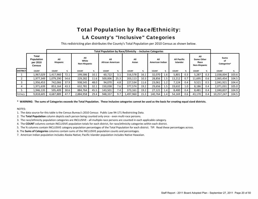
Total Population by Race/Ethnicity:LA County's "Inclusive" Categories
This redistricting plan distributes the County's Total Population per 2010 Census as shown below.
Total Population by Race/Ethnicity - Inclusive Categories
DISTRICT COUNT % COUNT % COUNT % COUNT % COUNT % COUNT % COUNT % COUNT %
1 1,417,960 72.1 199,586 10.1 60,722 3.1 316,578 16.1 32,070 1.6 5,801 0.3 5,287 0.3 2,038,004 103.6 2 1,079,290 54.6 229,282 11.6 500,006 25.3 203,113 10.3 28,856 1.5 13,212 0.7 11,695 0.6 2,065,454 104.5 3 742,066 37.9 938,545 48.0 94,070 4.8 227,534 11.6 23,061 1.2 7,124 0.4 9,521 0.5 2,041,921 104.4 4 853,164 43.3 632,781 32.1 150,038 7.6 377,574 19.2 29,656 1.5 19,632 1.0 8,186 0.4 2,071,031 105.0 5 595,409 30.6 884,764 45.5 143,501 7.4 373,161 19.2 27,121 1.4 8,400 0.4 8,481 0.4 2,040,837 104.9
TOTALS: 4,687,889 47.7 2,884,958 29.4 948,337 9.7 1,497,960 15.3 140,764 1.4 54,169 0.6 43,170 0.4 10,257,247 104.5
* WARNING: The sums of Categories exceeds the Total Population. These Inclusive categories cannot be used as the basis for creating equal sized districts.
NOTES:1. The data source for this table is the Census Bureau's 2010 Census: Public Law 94-171 Redistricting Data.2. The Total Population column depicts each person being counted only once - even multi-race persons.3. The race/ethnicity population categories are INCLUSIVE - all multiple-race persons are counted in each applicable category. 4. The COUNT columns contain INCLUSIVE population totals for each district, for race/ethnicity categories within each district. 5. The % columns contain INCLUSIVE category population percentages of the Total Population for each district. TIP: Read these percentages across.6. The Sums of Categories columns contain sums of the INCLUSIVE population counts and percentages.7. American Indian population includes Alaska Native; Pacific Islander population includes Native Hawaiian.
1,971,639 1,946,135 9,818,605
Total Population per 2010 Census
All Hispanic
1,956,453
COUNT
Sums of
Categories*
All Pacific Islander
All Some Other
Race Non-Hispanic
1,967,029 1,977,349
All White
Non-Hispanic
All African American
All Asian
All American Indian
Staff Report - 2011 Board Adopted Plan - September 27, 2011 Page 20 of 50

Registered Voters by Race/Ethnicity (March 2011)This redistricting plan distributes the County's Registered Voters as of March 2011 as shown below.
Ethnicity - Determined by Surname
DISTRICT COUNT % COUNT % COUNT % COUNT % COUNT % COUNT % COUNT % COUNT % %
1 435,106 59.1 7,871 1.1 6,571 0.9 38,535 5.2 2,851 0.4 16,339 2.2 17,199 2.3 211,543 28.7 100 2 237,239 29.2 13,214 1.6 8,843 1.1 8,085 1.0 4,620 0.6 3,572 0.4 13,476 1.7 524,369 64.5 100 3 195,093 20.4 8,995 0.9 5,808 0.6 13,795 1.4 8,542 0.9 5,475 0.6 14,415 1.5 703,831 73.6 100 4 282,755 28.7 17,329 1.8 14,313 1.5 38,107 3.9 8,546 0.9 8,172 0.8 19,267 2.0 596,893 60.6 100 5 191,551 19.5 13,730 1.4 7,545 0.8 47,226 4.8 7,502 0.8 9,505 1.0 15,088 1.5 691,569 70.3 100
TOTALS: 1,341,744 30.0 61,139 1.4 43,080 1.0 145,748 3.3 32,061 0.7 43,063 1.0 79,445 1.8 2,728,205 61.0 100
NOTES:1.2.
3.
4.5.6.7.8.
955,954 985,382
813,418
Total Registered March 2011
Latino or Spanish
COUNT
736,015
Korean Japanese FilipinoVietnamese Not ClassifiedChinese Indian
Ethnicity - Determined by matching voter surname against lists of surnames considered to be predictive of listed ethnicity.The COUNT columns contain registered voter totals for each district, and for Ethnicity - determined by surname, within each district. The % columns contain registered voter percentages for each surname-based ethnicity. TIP: Read these percentages across.
983,716 4,474,485
The data source for the voter registration numbers in this table is the County of Los Angeles' Registrar-Recorder/County Clerk.
"Not Classified" registrants include all other race/ethnic categories except those identified by the lists as Asian or Hispanic by surname. Currently there are no surname lists that have been recognized as predictive of persons who are African American.
"Latino" or "Spanish" surname source: Census of Population and Housing, 1980 - Spanish Surname List Technical Documentation Prepared by Data Access and Use Staff, Data User Services Division, Bureau of the Census. - Washington: the Bureau, 1980. This list has been accepted by various courts as well as the Justice Department in Voting Rights cases.Asian surname source: Lauderdale, Diane and Bert Kestenbaum. 2000. "Asian American Ethnic Identification by Surname," Population and Development Review 19(3), pp. 283-300
Staff Report - 2011 Board Adopted Plan - September 27, 2011 Page 21 of 50

Registered Voters by Political Party Affiliation (March 2011)This redistricting plan distributes the County's Registered Voters as of March 2011 as shown below.
DISTRICT COUNT % COUNT % COUNT % COUNT % COUNT % COUNT % COUNT % COUNT % %
1 415,131 56.4 131,567 17.9 13,454 1.8 2,892 0.4 3,848 0.5 6,244 0.8 157,803 21.4 5,076 0.7 100 2 538,641 66.2 94,725 11.6 14,679 1.8 2,693 0.3 3,556 0.4 5,199 0.6 146,542 18.0 7,383 0.9 100 3 504,306 52.8 189,152 19.8 20,305 2.1 5,404 0.6 6,558 0.7 4,012 0.4 216,067 22.6 10,150 1.1 100 4 445,786 45.2 292,499 29.7 21,623 2.2 5,010 0.5 4,637 0.5 4,666 0.5 203,105 20.6 8,056 0.8 100 5 392,916 39.9 340,003 34.6 23,683 2.4 4,957 0.5 4,644 0.5 3,470 0.4 205,398 20.9 8,645 0.9 100
TOTALS: 2,296,780 51.3 1,047,946 23.4 93,744 2.1 20,956 0.5 23,243 0.5 23,591 0.5 928,915 20.8 39,310 0.9 100
NOTES:1. The data source for the voter registration numbers in this table is the County of Los Angeles' Registrar-Recorder/County Clerk.2. The COUNT columns contain registered voter totals for each district and political affiliation.3. The % columns contain registered voter percentages for each of the above identified political parties. TIP: Read these percentages across.
Political Party Affiliation
COUNT
736,015
Libertarian Green
955,954 985,382 983,716
4,474,485
Some OtherPeace and Freedom
Decline to State / No Party
813,418
Total Registered March 2011
Democrat Republican American Independent
Staff Report - 2011 Board Adopted Plan - September 27, 2011 Page 22 of 50

Registered Voters by Gender (March 2011)This redistricting plan distributes the County's Registered Voters as of March 2011 as shown below.
DISTRICT COUNT % COUNT % COUNT % %
1 332,934 45.2 395,103 53.7 7,978 1.1 100 2 351,422 43.2 449,599 55.3 12,397 1.5 100 3 448,657 46.9 499,315 52.2 7,982 0.8 100 4 451,334 45.8 523,794 53.2 10,254 1.0 100 5 448,258 45.6 525,791 53.4 9,667 1.0 100
TOTALS: 2,032,605 45.4 2,393,602 53.5 48,278 1.1 100
NOTES:1. The data source for the voter registration numbers in this table is the County of Los Angeles' Registrar-Recorder/County Clerk.2. The COUNT columns contain registered voter totals for each district and gender.3. The % columns contain registered voter percentages for each gender. TIP: Read these percentages across.
Unknown
Gender
COUNT
736,015
Total Registered March 2011
Male Female
813,418 955,954 985,382 983,716
4,474,485
Staff Report - 2011 Board Adopted Plan - September 27, 2011 Page 23 of 50

Registered Voters by Age (March 2011)This redistricting plan distributes the County's Registered Voters as of March 2011 as shown below.
DISTRICT COUNT % COUNT % COUNT % COUNT % %
1 250,719 34.1 183,850 25.0 165,545 22.5 135,901 18.5 100 2 265,700 32.7 209,624 25.8 194,011 23.9 144,083 17.7 100 3 272,392 28.5 259,664 27.2 236,540 24.7 187,358 19.6 100 4 274,088 27.8 264,427 26.8 255,023 25.9 191,844 19.5 100 5 246,573 25.1 265,529 27.0 275,941 28.1 195,673 19.9 100
TOTALS: 1,309,472 29.3 1,183,094 26.4 1,127,060 25.2 854,859 19.1 100
NOTES:1. The data source for the voter registration numbers in this table is the County of Los Angeles' Registrar-Recorder/County Clerk.2. The COUNT columns contain registered voter totals by age group.3. The % columns contain registered voter percentages for each of the above age groups. TIP: Read these percentages across.
Age Group
COUNT
736,015
Total Registered
March 201118 to 34 35 to 49 50 to 64 65 and up
813,418 955,954 985,382 983,716
4,474,485
Staff Report - 2011 Board Adopted Plan - September 27, 2011 Page 24 of 50

Voting Age Population by Gender from American Community Survey
This redistricting plan distributes the County's Voting Age Population by Gender per ACS data as shown below.
Gender
DISTRICT COUNT % COUNT % %
1 724,682 50.2 717,655 49.8 100 2 697,798 48.2 749,873 51.8 100 3 767,936 49.5 783,790 50.5 100 4 723,968 48.6 764,766 51.4 100 5 716,755 48.2 769,174 51.8 100
TOTALS: 3,631,139 49.0 3,785,258 51.0 100
NOTES:1.
2.3.
The COUNT columns contain voting age population by gender.The % columns contain voting age population by gender. TIP: Read these percentages across.
Total Voting Age Population
Male Female
1,488,734 1,485,929 7,416,397
COUNT
1,442,337 1,447,671 1,551,726
The data source for the percentages of the voting age population by gender in this table is the American Community Survey (ACS). The ACS is an ongoing statistical survey by the U.S. Census Bureau, sent to approximately 250,000 addresses monthly (or 3 million per year). ACS estimates are based on data collected from January 1, 2005 to December 31, 2009, and are not 2010 Census data. The percentages of the voting age population from the ACS were applied to the 2010 Census counts of the voting age population at the census block level to obtain estimates of the voting age population by gender as of April 1, 2010.
Staff Report - 2011 Board Adopted Plan - September 27, 2011 Page 25 of 50

Voting Age Citizen by Gender from American Community Survey
This redistricting plan distributes the County's Voting Age Citizen by Gender per ACS data as shown below.
Gender
DISTRICT COUNT % COUNT % %
1 468,146 49.4 478,626 50.6 100 2 452,297 47.0 510,509 53.0 100 3 581,144 49.1 603,459 50.9 100 4 584,492 48.5 621,588 51.5 100 5 606,977 48.5 644,394 51.5 100
TOTALS: 2,693,056 48.5 2,858,576 51.5 100
NOTES:1.
2. The COUNT columns contain voting age citizen by gender.3. The % columns contain voting age citizen by gender. TIP: Read these percentages across.
962,806
Total Voting Age
Citizen Male Female
COUNT
946,772
1,184,603 1,206,080 1,251,371 5,551,632
The data source for the percentages of the voting age citizen population by gender in this table is the American Community Survey (ACS). The ACS is an ongoing statistical survey by the U.S. Census Bureau, sent to approximately 250,000 addresses monthly (or 3 million per year). ACS estimates are based on data collected from January 1, 2005 to December 31, 2009, and are not 2010 Census data. The percentages of the voting age citizen population from the ACS were applied to the 2010 Census counts of the voting age population at the census block level to obtain estimates of the voting age citizen population by gender as of April 1, 2010.
Staff Report - 2011 Board Adopted Plan - September 27, 2011 Page 26 of 50

Voting Age Citizen by DOJ Race/Ethnicity Categoriesfrom American Community Survey
This redistricting plan distributes the County's Voting Age Citizen Population per ACS data shown below.
Voting Age Citizen by Race/Ethnicity - Department of Justice (DOJ) Categories
DISTRICT COUNT % COUNT % COUNT % COUNT % COUNT % COUNT % COUNT % COUNT % %
1 565,245 59.7 156,651 16.5 35,648 3.8 179,438 19.0 3,364 0.4 1,392 0.1 1,440 0.2 3,594 0.4 1002 327,346 34.0 168,753 17.5 346,836 36.0 99,770 10.4 3,087 0.3 4,805 0.5 2,839 0.3 9,370 1.0 1003 282,120 23.8 705,163 59.5 59,097 5.0 121,411 10.2 4,913 0.4 2,534 0.2 3,177 0.3 6,188 0.5 1004 395,898 32.8 493,513 40.9 91,947 7.6 201,069 16.7 6,421 0.5 7,065 0.6 2,760 0.2 7,407 0.6 1005 296,024 23.7 648,023 51.8 86,532 6.9 201,607 16.1 6,742 0.5 2,461 0.2 3,155 0.3 6,827 0.5 100
TOTALS 1,866,633 33.6 2,172,103 39.1 620,060 11.2 803,295 14.5 24,527 0.4 18,257 0.3 13,371 0.2 33,386 0.6 100
NOTES:1.
2.3.4.5.6.
Hispanic (All Races)
962,806 1,184,603 1,206,080 1,251,371
Voting AgeCitizen
per 2010 Census
The % columns contain voting age citizen population percentages for each DOJ category within each district. TIP: Read these percentages across. American Indian population includes Alaska Native; Pacific Islander population includes Native Hawaiian.
Not Hispanic (NH) White
(Single Race)
The data source for the percentages of the voting age citizen population by Race/Ethnicity in this table is the American Community Survey (ACS). The ACS is an ongoing statistical survey by the U.S. Census Bureau, sent to approximately 250,000 addresses monthly (or 3 million per year). ACS estimates are based on data collected from January 1, 2005 to December 31, 2009, and are not 2010 Census data. The percentages of the voting age citizen population by Race/Ethnicity from the ACS were applied to the 2010 Census counts of the voting age population at the census block level to obtain estimates of the voting age citizen population by Race/Ethnicity as of April 1, 2010. The Voting Age Citizen column depicts each citizen, age 18 and older, being counted only once - even multi-race persons.The Department of Justice defined a set of 8 exclusive race/ethnicity population categories; persons are counted once in their applicable DOJ category.The COUNT columns contain voting age citizen population totals for each district, and for DOJ categories within each district.
NH African American
or NH African American/
White
NH Asian or NH
Asian/ White
NH American Indian
or NH American Indian/
White
5,551,632
NH Pacific Islander
or NH Pacific Islander/
White
NH Some Other Race
or NH Some Other Race/
White
NH Other
Multiple-Races (where more than 1
minority reach is listed)
COUNT
946,772
Staff Report - 2011 Board Adopted Plan - September 27, 2011 Page 27 of 50

Self-Reported Household Income from American Community Survey
This redistricting plan distributes the County's Household Incomes per ACS data as shown below.
Self-Reported Household Income
DISTRICT COUNT % COUNT % COUNT % COUNT % %
1 152,929 27.9 148,775 27.2 159,791 29.2 86,022 15.7 1002 189,537 30.7 166,347 27.0 168,720 27.3 92,626 15.0 1003 159,087 21.4 159,413 21.4 213,435 28.7 212,154 28.5 1004 119,850 18.0 139,811 21.0 210,196 31.6 194,563 29.3 1005 118,049 17.7 133,595 20.0 210,284 31.5 205,998 30.8 100
TOTALS 739,452 22.8 747,941 23.1 962,426 29.7 791,363 24.4 100
NOTES:1.
2.
3.
4.
The data source for the percentages of household income in this table is the American Community Survey (ACS). The ACS is an ongoing statistical survey by the U.S. Census Bureau, sent to approximately 250,000 addresses monthly (or 3 million per year). ACS estimates are based on data collected from January 1, 2005 to December 31, 2009, and are not 2010 Census data. The percentages of household income from the ACS were applied to the 2010 Census counts of the occupied housing units at the census block level to obtain estimates of household income as of April 1, 2010. The COUNT columns contain number of occupied households for each district, and for household income categories within each district. The % columns contain household percentages for each household income category within each district. TIP: Read these percentages across. For some RDUs that had housing units in the 2010 Census PL94-171 data, there were household variables with no data in the ACS 2005-2009 5 year merged file. Either these housing units were not in existence at the time of the ACS data collection or none were picked up in the ACS sampling. There were also small differences between the ACS based estimates and the PL94-171 counts caused by rounding. Consequently, our estimates for these variables will not match exactly the housing unit numbers in the PL94-171 and there are differences in our table totals. The number of households is 22 lower than the PL94-171 occupied housing units.
TotalHouseholds
Less than $25,000
$25,000 to$49,999
$50,000 to $99,999
$100,000 and up
744,089 664,420 667,926
3,241,182
COUNT
547,517 617,230
Staff Report - 2011 Board Adopted Plan - September 27, 2011 Page 28 of 50

Self-Reported Estimated Value of Homesfrom American Community Survey
This redistricting plan distributes the County's Estimated Value of Homes (Self-Reported) per ACS data as shown below.
Self-Estimated Home Values
DISTRICT COUNT % COUNT % COUNT % COUNT % %
1 52,087 9.2 181,405 32.1 288,726 51.2 42,203 7.5 1002 59,205 9.1 197,728 30.4 294,301 45.2 99,822 15.3 1003 37,757 4.7 130,457 16.4 335,948 42.2 291,204 36.6 1004 52,585 7.5 140,079 20.0 353,952 50.5 154,748 22.1 1005 67,095 9.5 165,631 23.4 344,379 48.6 131,311 18.5 100
TOTALS 268,729 7.9 815,300 23.8 1,617,306 47.3 719,288 21.0 100
NOTES:1.
2.
3.
4.
The COUNT columns contain number of occupied and unoccupied households for each district, and for home value categories within each district. The % columns contain household percentages for each home value category within each district. TIP: Read these percentages across. For some RDUs that had housing units in the 2010 Census PL94-171 data, there were household variables with no data in the ACS 2005-2009 5 year merged file. Either these housing units were not in existence at the time of the ACS data collection or none were picked up in the ACS sampling. There were also small differences between the ACS based estimates and the PL94-171 counts caused by rounding. Consequently, our estimates for these variables will not match exactly the housing unit numbers in the PL94-171 and there are differences in our table totals. The total number is 24,351 cases fewer than the PL94-171.
$750,000 and up
COUNT
3,420,623
TotalHouseholds
Less than $200,000 $200,000 to $399,999 $400,000 to $749,999
564,421 651,056 795,366 701,364 708,416
The data source for the percentages of self-reported estimated value of homes in this table is the American Community Survey (ACS). The ACS is an ongoing statistical survey by the U.S. Census Bureau, sent to approximately 250,000 addresses monthly (or 3 million per year). ACS estimates are based on data collected from January 1, 2005 to December 31, 2009, and are not 2010 Census data. The percentages of home values from the ACS were applied to the 2010 Census counts of all housing units at the census block level to obtain estimates of home values of April 1, 2010.
Staff Report - 2011 Board Adopted Plan - September 27, 2011 Page 29 of 50

Homeowners/Renters fromAmerican Community Survey
This redistricting plan distributes the County's household by homeowners/renters per ACS data as shown below.
Occupancy
DISTRICT COUNT % COUNT % %
1 243,214 44.4 304,320 55.6 100 2 232,458 37.7 384,780 62.3 100 3 325,018 43.7 419,062 56.3 100 4 367,551 55.3 296,887 44.7 100 5 410,727 61.5 257,189 38.5 100
TOTALS 1,578,968 48.7 1,662,238 51.3 100
NOTES:1.
2.3.4. For some RDUs that had housing units in the 2010 Census PL94-171 data, there were household variables with no data
in the ACS 2005-2009 5 year merged file. Either these housing units were not in existence at the time of the ACS data collection or none were picked up in the ACS sampling. There were also small differences between the ACS based estimates and the PL94-171 counts caused by rounding. Consequently, our estimates for these variables will not match exactly the housing unit numbers in the PL94-171 and there are differences in our table totals. The number of households is 2 cases more than the PL94-171 occupied housing units.
The COUNT columns contain households by homeowners/renters.
The % columns contain households by homeowners/renters. TIP: Read these percentages across.
617,238
TotalHouseholds
Homeowner Renter
COUNT
547,534
744,080 664,438 667,916
3,241,206
The data source for the percentages of homeowners/renters in this table is the American Community Survey (ACS). The ACS is an ongoing statistical survey by the U.S. Census Bureau, sent to approximately 250,000 addresses monthly (or 3 million per year). ACS estimates are based on data collected from January 1, 2005 to December 31, 2009, and are not 2010 Census data. The percentages of homeowners/renters from the ACS were applied to the 2010 Census counts of all occupied housing units at the census block level to obtain estimates of homeowners/renters of April 1, 2010.
Staff Report - 2011 Board Adopted Plan - September 27, 2011 Page 30 of 50

Communities Adopted District Assignments List: CountywideThis redistricting plan includes all or portions of the below-listed cities and unincorporated communities in the Adopted District.
* Communities that are in multiple Supervisorial Districts are marked with an asterisk. Countywide Community List Page 1 of 5
BENCHMARK DISTRICT
ADOPTED DISTRICT COMMUNITY
BENCHMARK DISTRICT
ADOPTED DISTRICT COMMUNITY
3 3 Agoura Hills 3 3 Hidden Hills5 5 Alhambra 1 1 Huntington Park5 5 Arcadia 1 1 Industry4 4 Artesia 2 2 Inglewood4 4 Avalon 1 1 Irwindale1 1 Azusa* 5 5 La Canada Flintridge5 1 Azusa* 4 4 La Habra Heights1 1 Baldwin Park 4 4 La Mirada1 1 Bell 1 1 La Puente1 1 Bell Gardens 5 5 La Verne4 4 Bellflower 4 4 Lakewood3 3 Beverly Hills 5 5 Lancaster5 5 Bradbury 2 2 Lawndale5 5 Burbank 4 4 Lomita3 3 Calabasas 4 4 Long Beach2 2 Carson 2 2 Lynwood4 4 Cerritos 3 3 Malibu5 1 Claremont 4 4 Manhattan Beach1 1 Commerce 1 1 Maywood2 2 Compton 5 5 Monrovia5 5 Covina 1 1 Montebello1 1 Cudahy 1 1 Monterey Park2 2 Culver City 4 4 Norwalk4 4 Diamond Bar 5 5 Palmdale4 4 Downey 4 4 Palos Verdes Estates5 5 Duarte 4 4 Paramount1 1 El Monte 5 5 Pasadena4 4 El Segundo 1 1 Pico Rivera*2 2 Gardena 4 1 Pico Rivera*5 5 Glendale 1 1 Pomona5 5 Glendora 4 4 Rancho Palos Verdes4 4 Hawaiian Gardens 4 4 Redondo Beach2 2 Hawthorne* 4 4 Rolling Hills4 2 Hawthorne* 4 4 Rolling Hills Estates4 4 Hermosa Beach 1 1 Rosemead
Staff Report - 2011 Board Adopted Plan - September 27, 2011 Page 31 of 50

Communities Adopted District Assignments List: CountywideThis redistricting plan includes all or portions of the below-listed cities and unincorporated communities in the Adopted District.
* Communities that are in multiple Supervisorial Districts are marked with an asterisk. Countywide Community List Page 2 of 5
BENCHMARK DISTRICT
ADOPTED DISTRICT COMMUNITY
BENCHMARK DISTRICT
ADOPTED DISTRICT COMMUNITY
5 5 San Dimas 1 1 LACity - Downtown*3 3 San Fernando 2 2 LACity - Downtown*5 5 San Gabriel 1 1 LACity - Eagle Rock/Glassell5 5 San Marino 2 2 LACity - East Hollywood*5 5 Santa Clarita 3 3 LACity - East Hollywood*1 4 Santa Fe Springs 1 1 LACity - El Sereno3 3 Santa Monica 3 3 LACity - Encino5 5 Sierra Madre 3 3 LACity - Fairfax4 4 Signal Hill 3 3 LACity - Granada Hills*1 1 South El Monte 5 5 LACity - Granada Hills*1 1 South Gate 2 2 LACity - Green Meadows5 5 South Pasadena 2 2 LACity - Hancock Park*5 5 Temple City 3 3 LACity - Hancock Park*4 4 Torrance 3 3 LACity - Hansen Dam*1 1 Vernon 5 5 LACity - Hansen Dam*1 1 Walnut 4 4 LACity - Harbor City1 1 West Covina* 2 2 LACity - Harbor Gateway5 1 West Covina* 1 1 LACity - Highland Park3 3 West Hollywood 3 3 LACity - Hollywood3 3 Westlake Village 3 3 LACity - Lake Balboa4 4 Whittier 3 3 LACity - Lake View Terrace*2 2 LACity - Adams/La Brea 5 5 LACity - Lake View Terrace*3 3 LACity - Arleta 1 1 LACity - Lincoln Heights1 1 LACity - Atwater Village* 1 1 LACity - Los Feliz*3 3 LACity - Atwater Village* 3 3 LACity - Los Feliz*2 2 LACity - Barnes City 2 2 LACity - Mar Vista3 3 LACity - Bel Air 2 1 LACity - Miracle Mile*3 3 LACity - Beverly Crest 2 2 LACity - Miracle Mile*1 1 LACity - Boyle Heights 3 3 LACity - Miracle Mile*3 3 LACity - Brentwood 3 3 LACity - Mission Hills3 3 LACity - Canoga Park* 3 3 LACity - North Hills5 5 LACity - Canoga Park* 3 3 LACity - North Hollywood5 5 LACity - Chatsworth 3 3 LACity - Northridge*5 5 LACity - Chatsworth Village 5 5 LACity - Northridge*2 2 LACity - Crenshaw 3 3 LACity - Pacific Palisades
Staff Report - 2011 Board Adopted Plan - September 27, 2011 Page 32 of 50

Communities Adopted District Assignments List: CountywideThis redistricting plan includes all or portions of the below-listed cities and unincorporated communities in the Adopted District.
* Communities that are in multiple Supervisorial Districts are marked with an asterisk. Countywide Community List Page 3 of 5
BENCHMARK DISTRICT
ADOPTED DISTRICT COMMUNITY
BENCHMARK DISTRICT
ADOPTED DISTRICT COMMUNITY
3 3 LACity - Pacoima 3 3 LACity - West LA*2 2 LACity - Palms 2 2 LACity - Westchester*3 3 LACity - Panorama City 2 4 LACity - Westchester*2 2 LACity - Playa Del Rey* 4 2 LACity - Westchester*4 4 LACity - Playa Del Rey* 4 4 LACity - Westchester*5 5 LACity - Porter Ranch 3 3 LACity - Westhills*3 3 LACity - Reseda 5 5 LACity - Westhills*4 4 LACity - San Pedro 1 1 LACity - Westlake*3 3 LACity - Sepulveda Basin 2 2 LACity - Westlake*5 5 LACity - Shadow Hills 3 3 LACity - Westwood3 3 LACity - Sherman Oaks 1 1 LACity - Wholesale1 1 LACity - Silverlake* 4 4 LACity - Wilmington3 1 LACity - Silverlake* 3 3 LACity - Winnetka1 1 LACity - South Park* 3 3 LACity - Woodland Hills2 2 LACity - South Park* 5 5 LACounty - Acton2 2 LACity - South Vermont 5 5 LACounty - Agua Dulce3 3 LACity - Studio City 5 5 LACounty - Altadena3 3 LACity - Sun Valley* 5 5 LACounty - Angeles National Forest5 5 LACity - Sun Valley* 5 5 LACounty - Arcadia5 5 LACity - Sunland 2 2 LACounty - Athens/Westmont3 3 LACity - Sylmar* 1 1 LACounty - Avocado Heights/Bassett*5 5 LACity - Sylmar* 1 4 LACounty - Avocado Heights/Bassett*3 3 LACity - Tarzana 1 1 LACounty - Avocado Heights/North Whittier3 3 LACity - Toluca Lake 1 1 LACounty - Azusa5 5 LACity - Tujunga 5 5 LACounty - Bradbury3 3 LACity - Valley Glen 3 3 LACounty - Calabasas3 3 LACity - Valley Village 5 5 LACounty - Canoga Park3 3 LACity - Van Nuys 5 5 LACounty - Canyon Country2 2 LACity - Venice* 5 5 LACounty - Castaic/Lake Hughes3 3 LACity - Venice* 5 5 LACounty - Castaic/Val Verde2 2 LACity - Vermont Square 4 4 LACounty - Cerritos2 2 LACity - Watts 4 4 LACounty - Channel Islands1 1 LACity - West Adams/Exposition Park* 5 5 LACounty - Charter Oak Islands2 2 LACity - West Adams/Exposition Park* 5 5 LACounty - Chatsworth2 2 LACity - West LA* 1 1 LACounty - Claremont*
Staff Report - 2011 Board Adopted Plan - September 27, 2011 Page 33 of 50
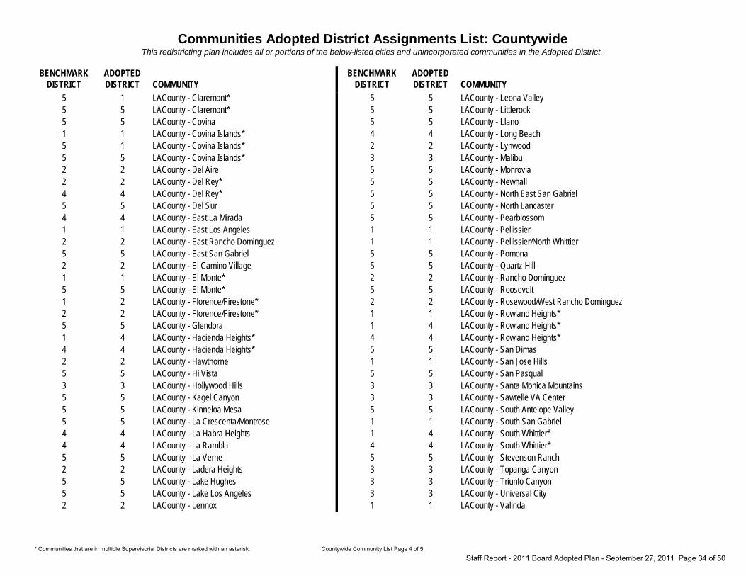
Communities Adopted District Assignments List: CountywideThis redistricting plan includes all or portions of the below-listed cities and unincorporated communities in the Adopted District.
* Communities that are in multiple Supervisorial Districts are marked with an asterisk. Countywide Community List Page 4 of 5
BENCHMARK DISTRICT
ADOPTED DISTRICT COMMUNITY
BENCHMARK DISTRICT
ADOPTED DISTRICT COMMUNITY
5 1 LACounty - Claremont* 5 5 LACounty - Leona Valley5 5 LACounty - Claremont* 5 5 LACounty - Littlerock5 5 LACounty - Covina 5 5 LACounty - Llano1 1 LACounty - Covina Islands* 4 4 LACounty - Long Beach5 1 LACounty - Covina Islands* 2 2 LACounty - Lynwood5 5 LACounty - Covina Islands* 3 3 LACounty - Malibu2 2 LACounty - Del Aire 5 5 LACounty - Monrovia2 2 LACounty - Del Rey* 5 5 LACounty - Newhall4 4 LACounty - Del Rey* 5 5 LACounty - North East San Gabriel5 5 LACounty - Del Sur 5 5 LACounty - North Lancaster4 4 LACounty - East La Mirada 5 5 LACounty - Pearblossom1 1 LACounty - East Los Angeles 1 1 LACounty - Pellissier2 2 LACounty - East Rancho Dominguez 1 1 LACounty - Pellissier/North Whittier5 5 LACounty - East San Gabriel 5 5 LACounty - Pomona2 2 LACounty - El Camino Village 5 5 LACounty - Quartz Hill1 1 LACounty - El Monte* 2 2 LACounty - Rancho Dominguez5 5 LACounty - El Monte* 5 5 LACounty - Roosevelt1 2 LACounty - Florence/Firestone* 2 2 LACounty - Rosewood/West Rancho Dominguez2 2 LACounty - Florence/Firestone* 1 1 LACounty - Rowland Heights*5 5 LACounty - Glendora 1 4 LACounty - Rowland Heights*1 4 LACounty - Hacienda Heights* 4 4 LACounty - Rowland Heights*4 4 LACounty - Hacienda Heights* 5 5 LACounty - San Dimas2 2 LACounty - Hawthorne 1 1 LACounty - San Jose Hills5 5 LACounty - Hi Vista 5 5 LACounty - San Pasqual3 3 LACounty - Hollywood Hills 3 3 LACounty - Santa Monica Mountains5 5 LACounty - Kagel Canyon 3 3 LACounty - Sawtelle VA Center5 5 LACounty - Kinneloa Mesa 5 5 LACounty - South Antelope Valley5 5 LACounty - La Crescenta/Montrose 1 1 LACounty - South San Gabriel4 4 LACounty - La Habra Heights 1 4 LACounty - South Whittier*4 4 LACounty - La Rambla 4 4 LACounty - South Whittier*5 5 LACounty - La Verne 5 5 LACounty - Stevenson Ranch2 2 LACounty - Ladera Heights 3 3 LACounty - Topanga Canyon5 5 LACounty - Lake Hughes 3 3 LACounty - Triunfo Canyon5 5 LACounty - Lake Los Angeles 3 3 LACounty - Universal City2 2 LACounty - Lennox 1 1 LACounty - Valinda
Staff Report - 2011 Board Adopted Plan - September 27, 2011 Page 34 of 50

Communities Adopted District Assignments List: CountywideThis redistricting plan includes all or portions of the below-listed cities and unincorporated communities in the Adopted District.
* Communities that are in multiple Supervisorial Districts are marked with an asterisk. Countywide Community List Page 5 of 5
BENCHMARK DISTRICT
ADOPTED DISTRICT COMMUNITY
BENCHMARK DISTRICT
ADOPTED DISTRICT COMMUNITY
2 2 LACounty - View Park/Windsor Hills1 1 LACounty - Walnut Park2 2 LACounty - West Carson*4 4 LACounty - West Carson*1 1 LACounty - West Puente Valley1 1 LACounty - West Valinda1 4 LACounty - West Whittier/Los Nietos*4 4 LACounty - West Whittier/Los Nietos*4 4 LACounty - Westfield3 3 LACounty - Westhills1 1 LACounty - Whittier Narrows1 1 LACounty - Whittier*4 4 LACounty - Whittier*2 2 LACounty - Willowbrook2 2 LACounty - Wiseburn
Staff Report - 2011 Board Adopted Plan - September 27, 2011 Page 35 of 50

* Communities that are in multiple Supervisorial Districts are marked with an asterisk. Community List by District List Page 1 of 5
BENCHMARK DISTRICT
ADOPTED DISTRICT COMMUNITY
BENCHMARK DISTRICT
ADOPTED DISTRICT COMMUNITY
1 1 Azusa* 1 1 LACounty - East Los Angeles5 1 Azusa* 1 1 LACounty - El Monte*1 1 Baldwin Park 1 1 LACounty - Pellissier1 1 Bell 1 1 LACounty - Pellissier/North Whittier1 1 Bell Gardens 1 1 LACounty - Rowland Heights*5 1 Claremont 1 1 LACounty - San Jose Hills1 1 Commerce 1 1 LACounty - South San Gabriel1 1 Cudahy 1 1 LACounty - Valinda1 1 El Monte 1 1 LACounty - Walnut Park1 1 Huntington Park 1 1 LACounty - West Puente Valley1 1 Industry 1 1 LACounty - West Valinda1 1 Irwindale 1 1 LACounty - Whittier Narrows1 1 La Puente 1 1 LACounty - Whittier*1 1 LACity - Atwater Village* 1 1 Maywood1 1 LACity - Boyle Heights 1 1 Montebello1 1 LACity - Downtown* 1 1 Monterey Park1 1 LACity - Eagle Rock/Glassell 1 1 Pico Rivera*1 1 LACity - El Sereno 4 1 Pico Rivera*1 1 LACity - Highland Park 1 1 Pomona1 1 LACity - Lincoln Heights 1 1 Rosemead1 1 LACity - Los Feliz* 1 1 South El Monte2 1 LACity - Miracle Mile* 1 1 South Gate1 1 LACity - Silverlake* 1 1 Vernon3 1 LACity - Silverlake* 1 1 Walnut1 1 LACity - South Park* 1 1 West Covina*1 1 LACity - West Adams/Exposition Park* 5 1 West Covina*1 1 LACity - Westlake* 2 2 Carson1 1 LACity - Wholesale 2 2 Compton1 1 LACounty - Avocado Heights/Bassett* 2 2 Culver City1 1 LACounty - Avocado Heights/North Whittier 2 2 Gardena1 1 LACounty - Azusa 2 2 Hawthorne*1 1 LACounty - Claremont* 4 2 Hawthorne*5 1 LACounty - Claremont* 2 2 Inglewood1 1 LACounty - Covina Islands* 2 2 LACity - Adams/La Brea5 1 LACounty - Covina Islands* 2 2 LACity - Barnes City
Communities & Adopted District Assignments List: By Adopted DistrictThis redistricting plan includes all or portions of the below-listed cities and unincorporated communities in the Adopted District.
Staff Report - 2011 Board Adopted Plan - September 27, 2011 Page 36 of 50

* Communities that are in multiple Supervisorial Districts are marked with an asterisk. Community List by District List Page 2 of 5
BENCHMARK DISTRICT
ADOPTED DISTRICT COMMUNITY
BENCHMARK DISTRICT
ADOPTED DISTRICT COMMUNITY
Communities & Adopted District Assignments List: By Adopted DistrictThis redistricting plan includes all or portions of the below-listed cities and unincorporated communities in the Adopted District.
2 2 LACity - Crenshaw 2 2 LACounty - Willowbrook2 2 LACity - Downtown* 2 2 LACounty - Wiseburn2 2 LACity - East Hollywood* 2 2 Lawndale2 2 LACity - Green Meadows 2 2 Lynwood2 2 LACity - Hancock Park* 3 3 Agoura Hills2 2 LACity - Harbor Gateway 3 3 Beverly Hills2 2 LACity - Mar Vista 3 3 Calabasas2 2 LACity - Miracle Mile* 3 3 Hidden Hills2 2 LACity - Palms 3 3 LACity - Arleta2 2 LACity - Playa Del Rey* 3 3 LACity - Atwater Village*2 2 LACity - South Park* 3 3 LACity - Bel Air2 2 LACity - South Vermont 3 3 LACity - Beverly Crest2 2 LACity - Venice* 3 3 LACity - Brentwood2 2 LACity - Vermont Square 3 3 LACity - Canoga Park*2 2 LACity - Watts 3 3 LACity - East Hollywood*2 2 LACity - West Adams/Exposition Park* 3 3 LACity - Encino2 2 LACity - West LA* 3 3 LACity - Fairfax2 2 LACity - Westchester* 3 3 LACity - Granada Hills*4 2 LACity - Westchester* 3 3 LACity - Hancock Park*2 2 LACity - Westlake* 3 3 LACity - Hansen Dam*2 2 LACounty - Athens/Westmont 3 3 LACity - Hollywood2 2 LACounty - Del Aire 3 3 LACity - Lake Balboa2 2 LACounty - Del Rey* 3 3 LACity - Lake View Terrace*2 2 LACounty - East Rancho Dominguez 3 3 LACity - Los Feliz*2 2 LACounty - El Camino Village 3 3 LACity - Miracle Mile*1 2 LACounty - Florence/Firestone* 3 3 LACity - Mission Hills2 2 LACounty - Florence/Firestone* 3 3 LACity - North Hills2 2 LACounty - Hawthorne 3 3 LACity - North Hollywood2 2 LACounty - Ladera Heights 3 3 LACity - Northridge*2 2 LACounty - Lennox 3 3 LACity - Pacific Palisades2 2 LACounty - Lynwood 3 3 LACity - Pacoima2 2 LACounty - Rancho Dominguez 3 3 LACity - Panorama City2 2 LACounty - Rosewood/West Rancho Dominguez 3 3 LACity - Reseda2 2 LACounty - View Park/Windsor Hills 3 3 LACity - Sepulveda Basin2 2 LACounty - West Carson* 3 3 LACity - Sherman Oaks
Staff Report - 2011 Board Adopted Plan - September 27, 2011 Page 37 of 50

* Communities that are in multiple Supervisorial Districts are marked with an asterisk. Community List by District List Page 3 of 5
BENCHMARK DISTRICT
ADOPTED DISTRICT COMMUNITY
BENCHMARK DISTRICT
ADOPTED DISTRICT COMMUNITY
Communities & Adopted District Assignments List: By Adopted DistrictThis redistricting plan includes all or portions of the below-listed cities and unincorporated communities in the Adopted District.
3 3 LACity - Studio City 4 4 Hawaiian Gardens3 3 LACity - Sun Valley* 4 4 Hermosa Beach3 3 LACity - Sylmar* 4 4 La Habra Heights3 3 LACity - Tarzana 4 4 La Mirada3 3 LACity - Toluca Lake 4 4 LACity - Harbor City3 3 LACity - Valley Glen 4 4 LACity - Playa Del Rey*3 3 LACity - Valley Village 4 4 LACity - San Pedro3 3 LACity - Van Nuys 2 4 LACity - Westchester*3 3 LACity - Venice* 4 4 LACity - Westchester*3 3 LACity - West LA* 4 4 LACity - Wilmington3 3 LACity - Westhills* 1 4 LACounty - Avocado Heights/Bassett*3 3 LACity - Westwood 4 4 LACounty - Cerritos3 3 LACity - Winnetka 4 4 LACounty - Channel Islands3 3 LACity - Woodland Hills 4 4 LACounty - Del Rey*3 3 LACounty - Calabasas 4 4 LACounty - East La Mirada3 3 LACounty - Hollywood Hills 1 4 LACounty - Hacienda Heights*3 3 LACounty - Malibu 4 4 LACounty - Hacienda Heights*3 3 LACounty - Santa Monica Mountains 4 4 LACounty - La Habra Heights3 3 LACounty - Sawtelle VA Center 4 4 LACounty - La Rambla3 3 LACounty - Topanga Canyon 4 4 LACounty - Long Beach3 3 LACounty - Triunfo Canyon 1 4 LACounty - Rowland Heights*3 3 LACounty - Universal City 4 4 LACounty - Rowland Heights*3 3 LACounty - Westhills 1 4 LACounty - South Whittier*3 3 Malibu 4 4 LACounty - South Whittier*3 3 San Fernando 4 4 LACounty - West Carson*3 3 Santa Monica 1 4 LACounty - West Whittier/Los Nietos*3 3 West Hollywood 4 4 LACounty - West Whittier/Los Nietos*3 3 Westlake Village 4 4 LACounty - Westfield4 4 Artesia 4 4 LACounty - Whittier*4 4 Avalon 4 4 Lakewood4 4 Bellflower 4 4 Lomita4 4 Cerritos 4 4 Long Beach4 4 Diamond Bar 4 4 Manhattan Beach4 4 Downey 4 4 Norwalk4 4 El Segundo 4 4 Palos Verdes Estates
Staff Report - 2011 Board Adopted Plan - September 27, 2011 Page 38 of 50

* Communities that are in multiple Supervisorial Districts are marked with an asterisk. Community List by District List Page 4 of 5
BENCHMARK DISTRICT
ADOPTED DISTRICT COMMUNITY
BENCHMARK DISTRICT
ADOPTED DISTRICT COMMUNITY
Communities & Adopted District Assignments List: By Adopted DistrictThis redistricting plan includes all or portions of the below-listed cities and unincorporated communities in the Adopted District.
4 4 Paramount 5 5 LACounty - Altadena4 4 Rancho Palos Verdes 5 5 LACounty - Angeles National Forest4 4 Redondo Beach 5 5 LACounty - Arcadia4 4 Rolling Hills 5 5 LACounty - Bradbury4 4 Rolling Hills Estates 5 5 LACounty - Canoga Park1 4 Santa Fe Springs 5 5 LACounty - Canyon Country4 4 Signal Hill 5 5 LACounty - Castaic/Lake Hughes4 4 Torrance 5 5 LACounty - Castaic/Val Verde4 4 Whittier 5 5 LACounty - Charter Oak Islands5 5 Alhambra 5 5 LACounty - Chatsworth5 5 Arcadia 5 5 LACounty - Claremont*5 5 Bradbury 5 5 LACounty - Covina5 5 Burbank 5 5 LACounty - Covina Islands*5 5 Covina 5 5 LACounty - Del Sur5 5 Duarte 5 5 LACounty - East San Gabriel5 5 Glendale 5 5 LACounty - El Monte*5 5 Glendora 5 5 LACounty - Glendora5 5 La Canada Flintridge 5 5 LACounty - Hi Vista5 5 La Verne 5 5 LACounty - Kagel Canyon5 5 LACity - Canoga Park* 5 5 LACounty - Kinneloa Mesa5 5 LACity - Chatsworth 5 5 LACounty - La Crescenta/Montrose5 5 LACity - Chatsworth Village 5 5 LACounty - La Verne5 5 LACity - Granada Hills* 5 5 LACounty - Lake Hughes5 5 LACity - Hansen Dam* 5 5 LACounty - Lake Los Angeles5 5 LACity - Lake View Terrace* 5 5 LACounty - Leona Valley5 5 LACity - Northridge* 5 5 LACounty - Littlerock5 5 LACity - Porter Ranch 5 5 LACounty - Llano5 5 LACity - Shadow Hills 5 5 LACounty - Monrovia5 5 LACity - Sun Valley* 5 5 LACounty - Newhall5 5 LACity - Sunland 5 5 LACounty - North East San Gabriel5 5 LACity - Sylmar* 5 5 LACounty - North Lancaster5 5 LACity - Tujunga 5 5 LACounty - Pearblossom5 5 LACity - Westhills* 5 5 LACounty - Pomona5 5 LACounty - Acton 5 5 LACounty - Quartz Hill5 5 LACounty - Agua Dulce 5 5 LACounty - Roosevelt
Staff Report - 2011 Board Adopted Plan - September 27, 2011 Page 39 of 50

* Communities that are in multiple Supervisorial Districts are marked with an asterisk. Community List by District List Page 5 of 5
BENCHMARK DISTRICT
ADOPTED DISTRICT COMMUNITY
BENCHMARK DISTRICT
ADOPTED DISTRICT COMMUNITY
Communities & Adopted District Assignments List: By Adopted DistrictThis redistricting plan includes all or portions of the below-listed cities and unincorporated communities in the Adopted District.
5 5 LACounty - San Dimas5 5 LACounty - San Pasqual5 5 LACounty - South Antelope Valley5 5 LACounty - Stevenson Ranch5 5 Lancaster5 5 Monrovia5 5 Palmdale5 5 Pasadena5 5 San Dimas5 5 San Gabriel5 5 San Marino5 5 Santa Clarita5 5 Sierra Madre5 5 South Pasadena5 5 Temple City
Staff Report - 2011 Board Adopted Plan - September 27, 2011 Page 40 of 50

County Facilities Adopted District Assignments List: CountywideThe below-listed County facilities are located within the indicated adopted districts and 2010 Census Tracts.
Facilities List: Page 1 of 10
FACILITY GROUP NAME ADDRESS CITYBENCHMARK
DISTRICTADOPTED DISTRICT
CENSUS TRACT
Airports BRACKETT FIELD 1615 W MCKINLEY AVE LA VERNE 5 5 4013.04Airports COMPTON AIRPORT 901 W ALONDRA BLVD COMPTON 2 2 5429.00Airports EL MONTE AIRPORT 4233 N SANTA ANITA AVE EL MONTE 1 1 4324.02Airports FOX AIRFIELD 4555 W AVE G LANCASTER 5 5 9009.00Airports WHITEMAN AIRPORT 12653 OSBORNE ST PACOIMA 3 3 1047.04
Botanic Gardens DESCANSO GARDENS 1418 DESCANSO DR LA CANADA FLINTRIDGE 5 5 4607.00Botanic Gardens LOS ANGELES COUNTY ARBORTEUM 301 N BALDWIN AVE ARCADIA 5 5 4307.01Botanic Gardens SOUTH COAST BOTANIC GARDEN 26300 CRENSHAW BLVD PALOS VERDES PENINSULA 4 4 6702.01Botanic Gardens VIRGINIA ROBINSON GARDENS 1008 ELDEN WAY BEVERLY HILLS 3 3 7007.00
Comprehensive Health Center DHS-EDWARD ROYBAL COMPREHENSIVE HEALTH CENTER 245 S FETTERLY AVE EAST LOS ANGELES 1 1 5304.00Comprehensive Health Center DHS-EL MONTE COMPREHENSIVE HEALTH CENTER 10953 RAMONA BLVD EL MONTE 1 1 4327.00Comprehensive Health Center DHS-H CLAUDE HUDSON COMPREHENSIVE HEALTH CTR 2829 S GRAND AVE LOS ANGELES 1 1 2246.00Comprehensive Health Center DHS-H H HUMPHREY COMPREHENSIVE HEALTH CENTER 5850 S MAIN ST LOS ANGELES 2 2 2392.02Comprehensive Health Center DHS-LONG BEACH COMPREHENSIVE HEALTH CENTER 1333 CHESTNUT AVE LONG BEACH 4 4 5754.01Comprehensive Health Center DHS-MID VALLEY COMPREHENSIVE HEALTH CENTER 8121 VAN NUYS BLVD PANORAMA CITY 3 3 1200.20
County Complexes ANTELOPE VALLEY ADMINISTRATIVE CENTER 251 E AVE K-6 LANCASTER 5 5 9005.04County Complexes BELLFLOWER CIVIC CENTER 9945 FLOWER ST BELLFLOWER 4 4 5542.04County Complexes COMPTON CIVIC CENTER 200 W COMPTON BLVD COMPTON 2 2 5425.02County Complexes CULVER CITY REGIONAL ASSESSOR'S OFFICE AND LIBRARY 4909 OVERLAND AVE CULVER CITY 2 2 7027.00County Complexes DOWNEY/RANCHO COMPLEX 7400 E IMPERIAL HWY DOWNEY 4 4 5516.00County Complexes DPW HEADQUARTERS COMPLEX 900 S FREMONT AVE ALHAMBRA 5 5 4808.02County Complexes EAST LOS ANGELES CIVIC CENTER 214 S FETTERLY AVE EAST LOS ANGELES 1 1 5304.00County Complexes EASTERN AVENUE COMPLEX 11000 N EASTERN AVE LOS ANGELES 1 1 5306.02County Complexes EL MONTE CIVIC CENTER 11234 VALLEY BLVD EL MONTE 1 1 4332.00County Complexes FERGUSON COMPLEX 5555 FERGUSON DR CITY OF COMMERCE 1 1 5323.03County Complexes HALL OF JUSTICE 211 W TEMPLE ST LOS ANGELES 1 1 2074.00County Complexes LAWNDALE CIVIC CENTER 14616 GREVILLEA AVE LAWNDALE 2 2 6039.00County Complexes LENNOX ADMINISTRATIVE CENTER 10828 S CONDON AVE LENNOX 2 2 6016.00County Complexes LESAGE COMPLEX 510 S VERMONT AVE LOS ANGELES 2 2 2111.20County Complexes LOMITA ADMINISTRATIVE CENTER 24320 NARBONNE AVE LOMITA 4 4 6700.01County Complexes LOS ANGELES CIVIC CENTER 500 W TEMPLE ST LOS ANGELES 1 1 2074.00County Complexes MALIBU ADMINISTRATIVE CENTER 23519 W CIVIC CENTER WAY MALIBU 3 3 8005.04County Complexes MARINA DEL REY 13851 FIJI WAY MARINA DEL REY 4 4 7029.01County Complexes MONROVIA CIVIC CENTER 300 W MAPLE AVE MONROVIA 5 5 4309.01County Complexes NORWALK CIVIC CENTER 12720 NORWALK BLVD NORWALK 4 4 5523.01County Complexes POMONA CIVIC CENTER 350 W MISSION BLVD POMONA 1 1 4088.00County Complexes SANTA CLARITA ADMINISTRATIVE CENTER 23743 W VALENCIA BLVD SANTA CLARITA 5 5 9203.29County Complexes SHERIFF'S HEADQUARTERS COMPLEX 4700 W RAMONA BLVD MONTEREY PARK 1 1 4820.01County Complexes SOUTH EL MONTE CIVIC CENTER 1430 N CENTRAL AVE SOUTH EL MONTE 1 1 4337.00County Complexes SOUTH LA COUNTY ADMINISTRATIVE CENTER 8300 S VERMONT AVE LOS ANGELES 2 2 2383.20County Complexes THE ADAMS & GRAND COMPLEX 2615 S GRAND AVE LOS ANGELES 1 1 2246.00County Complexes VAN NUYS CIVIC CENTER 14400 ERWIN ST MALL VAN NUYS 3 3 1282.10County Complexes WEST COVINA CIVIC CENTER 1427 WEST COVINA PKWY WEST COVINA 5 1 4067.02County Complexes WEST HOLLYWOOD CIVIC CENTER 619 N SAN VICENTE BLVD WEST HOLLYWOOD 3 3 7004.00County Complexes WHITTIER CIVIC CENTER 7621 S PAINTER AVE WHITTIER 4 4 5018.04
Staff Report - 2011 Board Adopted Plan - September 27, 2011 Page 41 of 50

County Facilities Adopted District Assignments List: CountywideThe below-listed County facilities are located within the indicated adopted districts and 2010 Census Tracts.
Facilities List: Page 2 of 10
FACILITY GROUP NAME ADDRESS CITYBENCHMARK
DISTRICTADOPTED DISTRICT
CENSUS TRACT
Courts ALFRED J MC COURTNEY JUVENILE JUSTICE CENTER 1040 W AVE J LANCASTER 5 5 9007.03Courts ALHAMBRA COURTHOUSE 150 W COMMONWEALTH AVE ALHAMBRA 5 5 4810.01Courts BELLFLOWER COURTHOUSE 10025 E FLOWER ST BELLFLOWER 4 4 5542.04Courts BEVERLY HILLS COURTHOUSE 9355 BURTON WAY BEVERLY HILLS 3 3 7008.01Courts BURBANK COURTHOUSE 300 E OLIVE AVE BURBANK 5 5 3107.02Courts CATALINA COURTHOUSE 215 SUMNER AVE AVALON 4 4 5990.00Courts CENTRAL ARRAIGNMENT COURTHOUSE 429 BAUCHET ST LOS ANGELES 1 1 2060.20Courts CENTRAL CIVIL WEST COURTHOUSE 600 S COMMONWEALTH AVE LOS ANGELES 2 2 2111.20Courts CHATSWORTH COURTHOUSE 9425 PENFIELD AVE CHATSWORTH 5 5 1133.03Courts CLARA SHORTRIDGE FOLTZ CRIMINAL JUSTICE CENTER 210 W TEMPLE ST LOS ANGELES 1 1 2074.00Courts COMPTON COURTHOUSE 200 W COMPTON BLVD COMPTON 2 2 5425.02Courts DAVID V KENYON JUVENILE JUSTICE CENTER 7625 S CENTRAL AVE LOS ANGELES 2 2 2395.02Courts DOWNEY COURTHOUSE 7500 E IMPERIAL HWY DOWNEY 4 4 5516.00Courts EAST LOS ANGELES COURTHOUSE 4848 E CIVIC CENTER WAY EAST LOS ANGELES 1 1 5304.00Courts EAST LOS ANGELES COURTHOUSE 214 S FETTERLY AVE EAST LOS ANGELES 1 1 5304.00Courts EDMUND EDELMAN CHILDREN'S COURT 201 CENTRE PLAZA DR MONTEREY PARK 1 1 4820.01Courts EL MONTE COURTHOUSE 11234 E VALLEY BLVD EL MONTE 1 1 4332.00Courts GLENDALE COURTHOUSE 600 E BROADWAY GLENDALE 5 5 3022.01Courts HOLLYWOOD COURTHOUSE 5925 HOLLYWOOD BLVD HOLLYWOOD 3 3 1910.00Courts HUNTINGTON PARK COURTHOUSE 6548 MILES AVE HUNTINGTON PARK 1 1 5331.06Courts INGLEWOOD COURTHOUSE 1 REGENT ST INGLEWOOD 2 2 6012.11Courts INGLEWOOD JUVENILE COURT 110 E REGENT ST INGLEWOOD 2 2 6012.11Courts LANCASTER JUVENILE COURTHOUSE 1000 W AVENUE J LANCASTER 5 5 9007.03Courts LONG BEACH COURTHOUSE 415 W OCEAN BLVD LONG BEACH 4 4 5760.01Courts LOS ANGELES AIRPORT COURTHOUSE 11701 S LA CIENEGA BLVD LOS ANGELES 2 2 6022.00Courts LOS PADRINOS-JUVENILE COURT-1 7281 E QUILL DR DOWNEY 4 4 5515.01Courts MALIBU ADMINISTRATIVE CENTER AND COURTHOUSE 23519 W CIVIC CENTER WAY MALIBU 3 3 8005.04Courts MENTAL HEALTH COURTHOUSE 1150 N SAN FERNANDO RD LOS ANGELES 1 1 1853.20Courts METROPOLITAN COURTHOUSE 1945 S HILL ST LOS ANGELES 1 1 2240.20Courts MICHAEL ANTONOVICH ANTELOPE VALLEY COURTHOUSE 42011 4TH ST W LANCASTER 5 5 9007.04Courts MICHAEL ANTONOVICH ANTELOPE VALLEY COURTHOUSE 421 W AVENUE M LANCASTER 5 5 9007.04Courts NORTHEAST JUVENILE JUSTICE CENTER BUILDING-1 1601 EASTLAKE AVE LOS ANGELES 1 1 2033.00Courts NORWALK COURTHOUSE 12720 NORWALK BLVD NORWALK 4 4 5523.01Courts PASADENA COURTHOUSE 300 E WALNUT ST PASADENA 5 5 4619.02Courts POMONA COURTHOUSE - NORTH 350 W MISSION BLVD POMONA 1 1 4088.00Courts POMONA COURTHOUSE - SOUTH 400 CIVIC CENTER PLZA POMONA 1 1 4088.00Courts REDONDO BEACH COURTHOUSE 117 W TORRANCE BLVD REDONDO BEACH 4 4 6212.04Courts REDONDO BEACH COURTHOUSE-ANNEX 105 W TORRANCE BLVD REDONDO BEACH 4 4 6212.04Courts SAN FERNANDO COURTHOUSE 900 3RD ST SAN FERNANDO 3 3 3202.01Courts SAN PEDRO COURTHOUSE 505 S CENTRE ST SAN PEDRO 4 4 2962.20Courts SAN PEDRO COURTHOUSE-ANNEX 638 S BEACON ST SAN PEDRO 4 4 2962.20Courts SANTA CLARITA COURTHOUSE 23747 W VALENCIA BLVD SANTA CLARITA 5 5 9203.29Courts SANTA MONICA COURTHOUSE 1725 MAIN ST SANTA MONICA 3 3 7019.02Courts STANLEY MOSK COURTHOUSE 110 N GRAND AVE LOS ANGELES 1 1 2074.00Courts STANLEY MOSK COURTHOUSE 111 N HILL ST LOS ANGELES 1 1 2074.00Courts SYLMAR JUVENILE COURTHOUSE-1 16350 FILBERT ST SYLMAR 3 3 1065.10Courts TORRANCE COURTHOUSE 825 MAPLE AVE TORRANCE 9050 4 4 6504.01Courts TORRANCE COURTHOUSE ANNEX 3221 TORRANCE BLVD TORRANCE 4 4 6504.01Courts VAN NUYS COURTHOUSE-EAST 6230 SYLMAR AVE VAN NUYS 3 3 1282.10
Staff Report - 2011 Board Adopted Plan - September 27, 2011 Page 42 of 50

County Facilities Adopted District Assignments List: CountywideThe below-listed County facilities are located within the indicated adopted districts and 2010 Census Tracts.
Facilities List: Page 3 of 10
FACILITY GROUP NAME ADDRESS CITYBENCHMARK
DISTRICTADOPTED DISTRICT
CENSUS TRACT
Courts VAN NUYS COURTHOUSE-WEST 14400 ERWIN ST VAN NUYS 3 3 1282.10Courts WEST COVINA COURTHOUSE 1427 WEST COVINA PKWY WEST COVINA 5 1 4067.02Courts WEST LOS ANGELES COURTHOUSE 1633 PURDUE AVE WEST LOS ANGELES 3 3 2673.00Courts WHITTIER COURTHOUSE 7339 S PAINTER AVE WHITTIER 4 4 5018.04
Cultural Centers BOB HOPE PATRIOTIC HALL 1816 S FIGUEROA ST LOS ANGELES 1 1 2240.20Cultural Centers FAIRPLEX 1101 W MCKINLEY AVE POMONA 1 1 4022.00Cultural Centers GEORGE C. PAGE MUSEUM/HANCOCK PARK-LA BREA TAR PITS 5801 WILSHIRE BLVD LOS ANGELES 3 3 2151.01Cultural Centers HOLLYWOOD BOWL 2301 N HIGHLAND AVE HOLLYWOOD 3 3 1897.02Cultural Centers JOHN ANSON FORD THEATER 2580 CAHUENGA BLVD EAST HOLLYWOOD 3 3 1897.01Cultural Centers LA PLAZA CULTURA Y ARTES 501 N MAIN ST LOS ANGELES 1 1 2071.02Cultural Centers MUSEUM OF ART 5905 WILSHIRE BLVD LOS ANGELES 3 3 2151.01Cultural Centers MUSEUM OF NATURAL HISTORY 900 EXPOSITION BLVD LOS ANGELES 2 2 2312.20Cultural Centers MUSIC CENTER 135 N GRAND AVE LOS ANGELES 1 1 2074.00Cultural Centers MUSIC-ANNEX BUILDING 301 N GRAND AVE LOS ANGELES 1 1 2074.00
Equestrian Facilities 72ND ST STAGING AREA 7101-015-903 LONG BEACH 4 4 5702.02Equestrian Facilities CASA DEL CABALLERO-UNDEVELOPED TANOBLE DR-5843-026-900 ALTADENA 5 5 4601.00Equestrian Facilities EATON CANYON STAGING AREA 2675 NEW YORK DRIVE PASADENA 5 5 4612.00Equestrian Facilities HASLEY CANYON EQUESTRIAN CENTER 28400 INDUSTRY DRIVE CASTAIC 5 5 9201.06Equestrian Facilities LARIO STAGING AREA 15701 FOOTHILL BLVD AZUSA 1 1 4008.00Equestrian Facilities LINCOLN SPS STAGING AREA 600 W. LOMA ALTA DRIVE ALTADENA 5 5 4603.01Equestrian Facilities LOS PINETOS STAGING AREA 14441 OLIVE VIEW DR SYLMAR 5 5 1060.10Equestrian Facilities LYMAN STAGING AREA 1900 SCARBOROUGH LANE SAN DIMAS 5 5 4037.03Equestrian Facilities MARSHALL CANYON STAGING AREA 6300 STEPHENS RANCH ROAD LA VERNE 5 5 4002.05Equestrian Facilities SAN DIMAS STAGING AREA 1210 PASEO GRACIA SAN DIMAS 5 5 4013.04Equestrian Facilities VALLEY CENTER STAGING AREA 1100 SOUTH VALLEY CENTER AVE SAN DIMAS 5 5 4013.12Equestrian Facilities WORKMAN MILL RD STAGING AREA 3301 WORKMAN MILL RD CITY OF INDUSTRY 4 4 4084.02
Golf Courses ALONDRA GC 16400 S PRAIRIE AVE LAWNDALE 2 2 6037.02Golf Courses ALTADENA GC 1456 E MENDOCINO ST ALTADENA 5 5 4612.00Golf Courses CHESTER WASHINGTON GC 1930 W 120TH ST LOS ANGELES 2 2 6027.00Golf Courses DIAMOND BAR GC 22751 E GOLDEN SPRINGS DR DIAMOND BAR 4 4 4033.19Golf Courses EATON CANYON GC 1150 N SIERRA MADRE VILLA PASADENA 5 5 4600.00Golf Courses EL CARISO GC 13100 ELDRIDGE ST SYLMAR 3 3 1061.11Golf Courses KNOLLWOOD GC 12040 BALBOA BLVD GRANADA HILLS 5 5 1066.45Golf Courses LA MIRADA GC 15501 E ALICANTE RD LA MIRADA 4 4 5036.02Golf Courses LAKEWOOD GC 3101 E CARSON ST LAKEWOOD 4 4 5713.00Golf Courses LOS AMIGOS GC 7295 E QUILL DR DOWNEY 4 4 5515.01Golf Courses LOS VERDES GC 7000 W LOS VERDES DR RANCHO PALOS VERDES 4 4 6704.16Golf Courses MAGGIE HATHAWAY GC 9637 S WESTERN AVE LOS ANGELES 2 2 2380.00Golf Courses MARSHALL CANYON GC 6100 N STEPHENS RANCH RD LA VERNE 5 5 4002.05Golf Courses MOUNTAIN MEADOWS GC 1875 FAIRPLEX DR POMONA 1 1 4013.04Golf Courses SANTA ANITA GC 405 S SANTA ANITA AVE ARCADIA 5 5 4307.21Golf Courses VICTORIA GC 340 E 192ND ST CARSON 2 2 5434.00Golf Courses WHITTIER NARROWS GC 8640 E RUSH ST ROSEMEAD 1 1 4824.02
Health Centers DHS-ANTELOPE VALLEY HEALTH CENTER 335 E AVE K-6 LANCASTER 5 5 9005.04Health Centers DHS-BELLFLOWER HEALTH CENTER 10005 E FLOWER ST BELLFLOWER 4 4 5542.04
Staff Report - 2011 Board Adopted Plan - September 27, 2011 Page 43 of 50

County Facilities Adopted District Assignments List: CountywideThe below-listed County facilities are located within the indicated adopted districts and 2010 Census Tracts.
Facilities List: Page 4 of 10
FACILITY GROUP NAME ADDRESS CITYBENCHMARK
DISTRICTADOPTED DISTRICT
CENSUS TRACT
Health Centers DHS-CANOGA PARK HEALTH CENTER (P/PP SITE) 7107 REMMET AVE CANOGA PARK 3 3 1345.20Health Centers DHS-DOLLARHIDE HEALTH CENTER 1108 N OLEANDER AVE COMPTON 2 2 5426.01Health Centers DHS-FAMILY MEDICAL CENTER 1403 LOMITA BLVD HARBOR CITY 4 4 2933.02Health Centers DHS-HAWAIIAN GARDENS HEALTH CENTER 22310 WARDHAM AVE HAWAIIAN GARDENS 4 4 5552.12Health Centers DHS-LA PUENTE HEALTH CENTER 15930 E CENTRAL AVE LA PUENTE 1 1 4077.02Health Centers DHS-LAKE LOS ANGELES COMMUNITY CLINIC 16921 E. AVE O, SPACE G PALMDALE 5 5 9001.03Health Centers DHS-LITTLEROCK COMMUNITY CLINIC 8201 PEARBLOSSOM HWY LITTLEROCK 5 5 9100.02Health Centers DHS-SAN FERNANDO HEALTH CENTER (NEW) 1212 PICO ST SAN FERNANDO 3 3 3203.00Health Centers DHS-SOUTH EAST VALLEY HEALTH CORP (P/PP SITE) 23763 VALENCIA BLVD VALENCIA 5 5 9203.29Health Centers DHS-SOUTHVALLEY HEALTH CENTER 38350 40TH ST PALMDALE 5 5 9107.11Health Centers DHS-SUN VALLEY HEALTH CENTER (P/PP SITE) 7223 N FAIR AVE SUN VALLEY 3 3 1230.10Health Centers DHS-THE LEAVEY CENTER (P/PP SITE) 512-522 S SAN PEDRO ST LOS ANGELES 2 2 2063.00Health Centers DHS-WILMINGTON PUBLIC HEALTH CENTER 1325 BROAD AVE WILMINGTON 4 4 2946.10Health Centers DPH-CURTIS TUCKER PUBLIC HEALTH CENTER 123 W MANCHESTER BLVD INGLEWOOD 2 2 6012.11Health Centers HIGH DESERT-EASY STREET REHABILITATION CLINIC 44900 N 60TH ST W LANCASTER 5 5 9010.03Health Centers HIGH DESERT-GLENCHUR CLINIC 45120 N 60TH ST W LANCASTER 5 5 9010.03Health Centers PH-BURBANK HEALTH CENTER 1101 W MAGNOLIA BLVD BURBANK 5 5 3108.00Health Centers PH-CENTRAL PUBLIC HEALTH CENTER 241 N FIGUEROA ST LOS ANGELES 1 1 2074.00Health Centers PH-DR RUTH TEMPLE PUBLIC HEALTH CENTER 3834 S WESTERN AVE LOS ANGELES 2 2 2313.00Health Centers PH-GLENDALE PUBLIC HEALTH CENTER 501 N GLENDALE AVE GLENDALE 5 5 3019.00Health Centers PH-HOLLYWOOD/ WILSHIRE PUBLIC HEALTH CENTER 5205 MELROSE AVE LOS ANGELES 3 3 1917.10Health Centers PH-MONROVIA PUBLIC HEALTH CENTER 330 W MAPLE AVE MONROVIA 5 5 4309.01Health Centers PH-PACOIMA PUBLIC HEALTH CENTER 13300 VAN NUYS BLVD PACOIMA 3 3 1046.10Health Centers PH-POMONA PUBLIC HEALTH CENTER 750 S PARK AVE POMONA 1 1 4088.00Health Centers PH-SOUTH BAY DIST/SAN PEDRO HEALTH CTR (P/PP) 122 W 8TH ST SAN PEDRO 4 4 2971.10Health Centers PH-SOUTH PUBLIC HEALTH CENTER 1522 E 102ND ST LOS ANGELES 2 2 2423.00Health Centers PH-TORRANCE PUBLIC HEALTH CENTER 2300 W CARSON ST TORRANCE 4 4 6509.02Health Centers PH-WEST HOLLYWOOD AIDS CENTER 621 N SAN VICENTE WEST HOLLYWOOD 3 3 7004.00Health Centers PH-WHITTIER PUBLIC HEALTH CENTER 7643 S PAINTER AVE WHITTIER 4 4 5018.04Health Centers PH-YVONNE BURKE/VENICE FAMILY HEALTH CENTER 2509 W PICO BLVD SANTA MONICA 3 3 7018.01
Jails/Detention Facilities BARRY J. NIDORF JUV HALL 16350 FILBERT ST SYLMAR 3 3 1065.10Jails/Detention Facilities CAMP AFFLERBAUGH 6631 N STEPHENS RANCH RD LA VERNE 5 5 4002.05Jails/Detention Facilities CAMP GLENN ROCKEY 1900 N SYCAMORE CANYON RD SAN DIMAS 5 5 4004.03Jails/Detention Facilities CAMP GONZALES 1301 N LAS VIRGENES RD CALABASAS 3 3 8003.30Jails/Detention Facilities CAMP HOLTON (TEMPORARILY CLOSED) 12653 N LITTLE TUJUNGA CANYON RD SAN FERNANDO 5 5 9302.00Jails/Detention Facilities CAMP KILPATRICK 427 S ENCINAL CANYON RD MALIBU 3 3 8004.06Jails/Detention Facilities CAMP LOUIS ROUTH (TEMPORARILY CLOSED) 12500 BIG TUJUNGA CANYON RD TUJUNGA 5 5 9800.26Jails/Detention Facilities CAMP MENDENHALL 42230 N LAKE HUGHES RD LAKE HUGHES 5 5 9201.02Jails/Detention Facilities CAMP MILLER 433 S. ENCINAL CANYON RD MALIBU 3 3 8004.06Jails/Detention Facilities CAMP MUNZ 42220 N LAKE HUGHES RD LAKE HUGHES 5 5 9201.02Jails/Detention Facilities CAMP PAIGE 6601 N STEPHENS RANCH RD LA VERNE 5 5 4002.05Jails/Detention Facilities CAMP SCOTT 28700 N BOUQUET CANYON RD SANTA CLARITA 5 5 9200.32Jails/Detention Facilities CAMP SCUDDER 28750 N BOUQUET CANYON RD SANTA CLARITA 5 5 9200.32Jails/Detention Facilities CENTRAL JUVENILE HALL 1605 EASTLAKE AVE LOS ANGELES 1 1 2033.00Jails/Detention Facilities CENTURY REGIONAL DETENTION FACILITY 11705 S ALAMEDA ST LYNWOOD 2 2 5405.01Jails/Detention Facilities CHALLENGER MEMORIAL YOUTH CENTER 5300 W AVENUE I LANCASTER 5 5 9010.03Jails/Detention Facilities DOROTHY KIRBY CENTER 1500 S MCDONNELL AVE COMMERCE 1 1 5315.02Jails/Detention Facilities LOS PADRINOS JUVENILE HALL 7285 QUILL DR DOWNEY 4 4 5515.01
Staff Report - 2011 Board Adopted Plan - September 27, 2011 Page 44 of 50

County Facilities Adopted District Assignments List: CountywideThe below-listed County facilities are located within the indicated adopted districts and 2010 Census Tracts.
Facilities List: Page 5 of 10
FACILITY GROUP NAME ADDRESS CITYBENCHMARK
DISTRICTADOPTED DISTRICT
CENSUS TRACT
Jails/Detention Facilities MEN'S CENTRAL JAIL 441 BAUCHET ST LOS ANGELES 1 1 2060.20Jails/Detention Facilities MIRA LOMA DETENTION FACILITY 45100 N 60TH ST W LANCASTER 5 5 9010.03Jails/Detention Facilities NORTH COUNTY CORRECTIONAL FACILITY 29340 THE OLD RD CASTAIC 5 5 9201.06Jails/Detention Facilities PITCHESS DETENTION CENTER EAST FACILITY 29310 THE OLD ROAD CASTAIC 5 5 9201.06Jails/Detention Facilities PITCHESS DETENTION CENTER NORTH FACILITY 29320 THE OLD ROAD CASTAIC 5 5 9201.06Jails/Detention Facilities PITCHESS DETENTION CENTER SOUTH FACILITY 29330 THE OLD ROAD CASTAIC 5 5 9201.06Jails/Detention Facilities TWIN TOWERS CORRECTIONAL FACILITY 450 BAUCHET ST LOS ANGELES 1 1 2060.20
Local Parks ACTON PARK 3751 SYRACUSE AVE ACTION 5 5 9108.05Local Parks ADVENTURE PARK 10130 S GUNN AVE WHITTIER 4 4 5032.02Local Parks ALLEN J MARTIN PARK 14830 E GIORDANO ST LA PUENTE 1 1 4073.02Local Parks AMIGO PARK 8700 S JUAREZ AVE WHITTIER 1 1 5004.03Local Parks ATHENS PARK 12603 S BROADWAY LOS ANGELES 2 2 5409.01Local Parks ATLANTIC AVENUE PARK 570 S ATLANTIC AVE EAST LOS ANGELES 1 1 5303.01Local Parks AVOCADO HEIGHTS PARK 14105 DON JULIAN RD BASSETT 1 1 4082.02Local Parks BASSETT PARK 510 N VINELAND AVE LA PUENTE 1 1 4070.02Local Parks BILL BLEVINS PARK 19500 WINDROSE DR ROWLAND HEIGHTS 4 4 4087.03Local Parks BODGER PARK 14900 S YUKON AVE HAWTHORNE 2 2 6037.04Local Parks CAROLYN ROSAS PARK 18500 FARJARDO ST ROWLAND HEIGHTS 4 4 4087.23Local Parks CHARLES WHITE PARK 77 MOUNTAIN VIEW ST ALTADENA 5 5 4610.00Local Parks CHARTER OAK PARK 20261 E COVINA BLVD COVINA 5 5 4038.01Local Parks CITY TERRACE PARK 1126 N HAZARD AVE EAST LOS ANGELES 1 1 5309.02Local Parks COL. LEON H. WASHINGTON PARK 8908 S MAIE AVE LOS ANGELES 2 2 5352.00Local Parks COPPERHILL PARK COPPER HILL RD & DEER SPRINGS DR SANTA CLARITA 5 5 9200.20Local Parks COUNTRYWOOD PARK 16817 E COPPER HILL RD HACIENDA HEIGHTS 4 4 4086.28Local Parks DALTON PARK 18867 E ARMSTEAD ST AZUSA 1 1 4040.00Local Parks DEL AIRE PARK 12601 S ISIS AVE HAWTHORNE 2 2 6022.00Local Parks DEL VALLE PARK 28201 W SLOAN CANYON RD CASTAIC 5 5 9201.04Local Parks DEXTER PARK 11053 N TRAIL RD SAN FERNANDO 5 5 1041.24Local Parks EAST RANCHO DOMINGUEZ PARK 15116 SOUTH ATLANTIC AVE COMPTON 2 2 5421.06Local Parks EASTSIDE ED HEREDIA BOXING CLUB 5127 E OLYMPIC BLVD EAST LOS ANGELES 1 1 5317.02Local Parks EL PARQUE NUESTRO 1675 GAGE AVE LOS ANGELES 1 2 5330.01Local Parks ENTERPRISE PARK 13055 CLOVIS AVE LOS ANGELES 2 2 5408.00Local Parks EUGENE A. OBREGON PARK 4021 E 1ST ST EAST LOS ANGELES 1 1 5310.00Local Parks EVERETT MARTIN PARK 35548 N 92ND ST E LITTLEROCK 5 5 9100.02Local Parks FAIR OAKS PARK 17468 HONEY MAPLE ST SANTA CLARITA 5 5 9200.43Local Parks FARNSWORTH PARK 568 E MOUNT CURVE AVE ALTADENA 5 5 4602.00Local Parks FRANKLIN D. ROOSEVELT PARK 7600 GRAHAM AVE LOS ANGELES 1 2 5349.00Local Parks GEORGE LANE PARK 5520 W AVE L-8 QUARTZ HILL 5 5 9011.01Local Parks GEORGE WASHINGTON CARVER PARK 1400 E 118TH ST LOS ANGELES 2 2 5407.00Local Parks GLORIA HEER PARK 18109 E GALLINETA ST ROWLAND HEIGHTS 4 4 4086.27Local Parks HASLEY CANYON PARK 28700 QUINCY ST CASTAIC 5 5 9201.18Local Parks HELEN KELLER PARK 1045 W 126TH ST LOS ANGELES 2 2 6028.02Local Parks HIGHLAND CAMROSE-PICNIC AREA 2101 N HIGHLAND AVE HOLLYWOOD 3 3 1897.02Local Parks JACKIE ROBINSON PARK 8773 E AVE R LITTLEROCK 5 5 9100.01Local Parks JAKE KUREDJIAN PARK 25265 PICO CANYON ROAD STEVENSON RANCH 5 5 9203.26Local Parks LADERA PARK 6027 LADERA PARK AVE LOS ANGELES 2 2 7031.00Local Parks LENNOX PARK 10828 S CONDON AVE LENNOX 2 2 6016.00Local Parks LOMA ALTA PARK 3330 N LINCOLN AVE ALTADENA 5 5 4603.01
Staff Report - 2011 Board Adopted Plan - September 27, 2011 Page 45 of 50

County Facilities Adopted District Assignments List: CountywideThe below-listed County facilities are located within the indicated adopted districts and 2010 Census Tracts.
Facilities List: Page 6 of 10
FACILITY GROUP NAME ADDRESS CITYBENCHMARK
DISTRICTADOPTED DISTRICT
CENSUS TRACT
Local Parks LOS ROBLES PARK 14906 E LOS ROBLES AVE HACIENDA HEIGHTS 4 4 4084.02Local Parks MANZANITA PARK 1747 S KWIS AVE HACIENDA HEIGHTS 4 4 4085.05Local Parks MARY MCLEOD BETHUNE PARK 1244 E 61ST ST LOS ANGELES 2 2 5328.00Local Parks MAYBERRY PARK 13201 E MEYER RD WHITTIER 1 4 5030.00Local Parks MICHILLINDA PARK 3800 MICHILLINDA DR PASADENA 5 5 4631.01Local Parks MIRA VISTA MINI PARK ORANGEDALE AVE AND MIRA VISTA AVE GLENDALE 5 5 3005.02Local Parks MONA PARK 2291 E 121ST ST COMPTON 2 2 5406.00Local Parks MONTEITH PARK (VIEW PARK TRIANGLE) 3700 MONTEITH DR LOS ANGELES 2 2 7032.00Local Parks MONUMENT PARK 800 E ALTADENA DR ALTADENA 5 5 4602.00Local Parks PAMELA PARK 2236 GOODALL AVE DUARTE 5 5 4312.00Local Parks PARK LEARNING GROVE COUNT PARK 1123 W 223RD ST TORRANCE 2 2 5435.03Local Parks PARQUE DE LOS SUENOS 1333 S. BONNIE BEACH PL LOS ANGELES 1 1 5313.02Local Parks PEARBLOSSOM PARK 33922 N 121ST ST E PEARBLOSSOM 5 5 9110.01Local Parks PECK ROAD WATER CONSERVATION PARK 5401 N PECK RD ARCADIA 5 5 4315.00Local Parks PEPPERBROOK PARK 1701 COUNTRYWOOD AVE HACIENDA HEIGHTS 4 4 4086.24Local Parks PICKENS CANYON PARK 2391 WEST FOOTHILL BLVD LA CRESCENTA 5 5 4606.00Local Parks PICO CANYON PARK 25600 PICO CANYON RD STEVENSON RANCH 5 5 9203.26Local Parks PIONEER PARK AVE J & 106TH ST WEST LANCASTER 5 5 9012.05Local Parks PLACERITA CANYON PARK 19152 PLACERITA CANYON RD NEWHALL 5 5 9302.00Local Parks REUBEN F. SALAZAR MEMORIAL PARK 3864 E WHITTIER BLVD EAST LOS ANGELES 1 1 5313.01Local Parks RIMGROVE PARK 747 N RIMGROVE DR VALINDA 1 1 4078.01Local Parks ROWLAND HEIGHTS PARK 1500 S BANIDA AVE ROWLAND HEIGHTS 4 4 4082.12Local Parks ROY CAMPANELLA PARK 14812 STANFORD AVE COMPTON 2 2 5411.00Local Parks RUEBEN INGOLD PARKWAY 4400 MOUNT VERNON DR LOS ANGELES 2 2 7031.00Local Parks SAN ANGELO PARK 245 S SAN ANGELO AVE BASSETT 1 1 4083.01Local Parks SANTA CATALINA ISLAND INTERPRETIVE CENTER 1202 AVALON CANYON RD AVALON 4 4 5991.00Local Parks SAYBROOK PARK 6300 E NORTHSIDE DR EAST LOS ANGELES 1 1 5319.02Local Parks SORENSEN PARK 11419 ROSEHEDGE DR WHITTIER 1 4 5010.02Local Parks STEINMETZ PARK 1545 S STIMSON AVE HACIENDA HEIGHTS 4 4 4086.31Local Parks STEPHEN SORENSON PARK 16801 EAST AVENUE P LAKE LOS ANGELES 1 4 5010.02Local Parks SUNSHINE PARK 515 S DEEPMEAD AVE LA PUENTE 1 1 4081.40Local Parks TESORO ADOBE HISTORIC PARK 29350 AVENIDA RANCHO TESORO VALENCIA 5 5 9201.02Local Parks THOMAS BURTON PARK 16490 SANTA BIANCA DR HACIENDA HEIGHTS 4 4 4086.24Local Parks TRAILVIEW PARK 2625 S SALEROSO DR ROWLAND HEIGHTS 4 4 4086.27Local Parks TWO STRIKE PARK 5107 ROSEMONT AVE LA CRESCENTA 5 5 3001.00Local Parks VALLEYDALE PARK 5525 N LARK ELLEN AVE AZUSA 1 1 4045.01Local Parks VASQUEZ ROCKS PARK 10700 W ESCONDIDO CANYON RD AGUA DULCE 5 5 9108.13Local Parks VETERAN'S MEMORIAL PARK 13000 SAYRE ST SYLMAR 3 3 1061.11Local Parks WALNUT NATURE PARK 2642 OLIVE ST WALNUT PARK 1 1 5348.03Local Parks WEST CREEK PARK 24247 VILLAGE CIRCLE VALENCIA 5 5 9201.08Local Parks WOODS AVENUE PARK PARKWAY- 5245-001-901, 5245-012-900 EAST LOS ANGELES 1 1 5317.02
Medical Centers HARBOR-UCLA MEDICAL CENTER 1000 W CARSON ST TORRANCE 2 2 5435.03Medical Centers HIGH DESERT HOSPITAL 45153 N 60TH ST W LANCASTER 5 5 9012.05Medical Centers LAC/USC MEDICAL CENTER 1200 N STATE ST LOS ANGELES 1 1 2033.00Medical Centers ML KING/DREW MEDICAL CENTER 12021 S WILMINGTON AVE LOS ANGELES 2 2 5407.00Medical Centers OLIVE VIEW MEDICAL CENTER 14445 OLIVE VIEW DR SYLMAR 5 5 1060.10Medical Centers RANCHO LOS AMIGOS MEDICAL CENTER 7601 E IMPERIAL HWY DOWNEY 4 4 5516.00
Staff Report - 2011 Board Adopted Plan - September 27, 2011 Page 46 of 50

County Facilities Adopted District Assignments List: CountywideThe below-listed County facilities are located within the indicated adopted districts and 2010 Census Tracts.
Facilities List: Page 7 of 10
FACILITY GROUP NAME ADDRESS CITYBENCHMARK
DISTRICTADOPTED DISTRICT
CENSUS TRACT
Natural Areas ACTON WASH SANCTUARY 5 5 9108.05Natural Areas ALPINE BUTTE WILDLIFE SANCTUARY E AVE O - 3078-019-900 LAKE LOS ANGELES 5 5 9100.01Natural Areas BIG ROCK CREEK WILDLIFE SANCTUARY 3078-017-900 5 5 9100.01Natural Areas BLALOCK SANCTUARY VALYERMO RD - 3037-028-900 LONGVIEW 5 5 9110.01Natural Areas BUTTE VALLEY WILDFLOWER SANCTUARY E AVE I - 3082-024-900, 3350-021-900, 3 LANCASTER 5 5 9001.02Natural Areas CARL GERHARDY WILDLIFE SANCTUARY 3338-010-900, 3338-011-901 LANCASTER 5 5 9001.02Natural Areas DEVILS PUNCHBOWL NATURAL AREA 28000 DEVILS PUNCHBOWL RD PEARBLOSSOM 5 5 9303.01Natural Areas EATON CANYON NATURAL AREA 1750 N ALTADENA DR PASADENA 5 5 4601.00Natural Areas JACKRABBIT FLATS WILDLIFE SANCTUARY E AVE T - 3039-020-901 LITTLEROCK 5 5 9100.02Natural Areas MESCAL WILDLIFE SANCTUARY ANTELOPE HWY 138 - 3088-010-900, 3089-0 VALYERMO 5 5 9110.01Natural Areas PHACELIA WILDFLOWER SANCTUARY 200TH - 3318-012-900 HI VISTA 5 5 9001.02Natural Areas THEODORE PAYNE WILDLIFE SANCTUARY 223RD ST E - 3032-009-901, 3032-010-903 LLANO 5 5 9110.01Natural Areas TUJUNGA PONDS WILDLIFE SANCTUARY 2549-002-902 SUNLAND 5 5 9800.21
Public Libraries PUBLIC LIBRARY-A C BILBREW LIBRARY 150 E EL SEGUNDO BLVD LOS ANGELES 2 2 5409.02Public Libraries PUBLIC LIBRARY-ACTION/AGUA DULCE LIBRARY 33792 CROWN VALLEY RD ACTION 5 5 9108.04Public Libraries PUBLIC LIBRARY-AGOURA HILLS LIBRARY 29901 LADYFACE CT AGOURA HILLS 3 3 8003.26Public Libraries PUBLIC LIBRARY-ALONDRA 11949 E ALONDRA BLVD NORWALK 4 4 5526.01Public Libraries PUBLIC LIBRARY-ANGELO M IACOBONI LIBRARY 4990 CLARK AVE LAKEWOOD 4 4 5708.00Public Libraries PUBLIC LIBRARY-ANTHONY QUINN LIBRARY 3965 E CESAR CHAVEZ AVE EAST LOS ANGELES 1 1 5309.02Public Libraries PUBLIC LIBRARY-ARTESIA 18722 S CLARKDALE AVE ARTESIA 4 4 5549.00Public Libraries PUBLIC LIBRARY-AVALON 215 SUMNER AVE AVALON 4 4 5990.00Public Libraries PUBLIC LIBRARY-BALDWIN PARK LIBRARY 4181 BALDWIN PARK BLVD BALDWIN PARK 1 1 4051.02Public Libraries PUBLIC LIBRARY-BELL 4411 E GAGE AVE BELL 1 1 5336.01Public Libraries PUBLIC LIBRARY-BELL GARDENS LIBRARY 7110 GARFIELD AVE BELL GARDENS 1 1 5340.01Public Libraries PUBLIC LIBRARY-CANYON COUNTRY LIBRARY 18601 SOLEDAD CANYON RD SANTA CLARITA 5 5 9200.35Public Libraries PUBLIC LIBRARY-CARSON REGIONAL LIBRARY 151 E CARSON ST CARSON 2 2 5438.01Public Libraries PUBLIC LIBRARY-CASTAIC LIBRARY 27971 SLOAN CANYON RD CASTAIC 5 5 9201.04Public Libraries PUBLIC LIBRARY-CHARTER OAK 20540 K ARROW HWY COVINA 5 5 4038.02Public Libraries PUBLIC LIBRARY-CHET HOLIFIELD 1060 S GREENWOOD AVE MONTEBELLO 1 1 5322.00Public Libraries PUBLIC LIBRARY-CITY TERRACE LIBRARY 4025 E CITY TERRACE DR EAST LOS ANGELES 1 1 5308.02Public Libraries PUBLIC LIBRARY-CLAREMONT LIBRARY 208 N HARVARD AVE CLAREMONT 5 1 4019.02Public Libraries PUBLIC LIBRARY-CLIFTON M BRAKENSIEK LIBRARY 9945 E FLOWER ST BELLFLOWER 4 4 5542.04Public Libraries PUBLIC LIBRARY-COMPTON LIBRARY 240 W COMPTON BLVD COMPTON 2 2 5425.02Public Libraries PUBLIC LIBRARY-CUDAHY 5218 SANTA ANA ST CUDAHY 1 1 5343.02Public Libraries PUBLIC LIBRARY-CULVER CITY LIBRARY 4975 OVERLAND AVE CULVER CITY 2 2 7027.00Public Libraries PUBLIC LIBRARY-DIAMOND BAR LIBRARY 1061 S GRAND AVE DIAMOND BAR 4 4 4033.23Public Libraries PUBLIC LIBRARY-DR. MARTIN LUTHER KING, JR. LIBRARY 17906 S AVALON BLVD CARSON 2 2 5433.21Public Libraries PUBLIC LIBRARY-DUARTE LIBRARY 1301 BUENA VISTA AVE DUARTE 5 5 4301.01Public Libraries PUBLIC LIBRARY-EAST LOS ANGELES LIBRARY 4837 E 3RD ST EAST LOS ANGELES 1 1 5304.00Public Libraries PUBLIC LIBRARY-EAST RANCHO DOMINGUEZ LIBRARY 4205 E COMPTON BLVD EAST COMPTON 2 2 5421.03Public Libraries PUBLIC LIBRARY-EL CAMINO REAL 4264 E WHITTIER BLVD LOS ANGELES 1 1 5313.01Public Libraries PUBLIC LIBRARY-EL MONTE 3224 TYLER AVE EL MONTE 1 1 4332.00Public Libraries PUBLIC LIBRARY-FLORENCE 1610 E FLORENCE AVE LOS ANGELES 2 2 5350.02Public Libraries PUBLIC LIBRARY-GARDENA/MAYME DEAR LIBRARY 1731 W GARDENA BLVD GARDENA 2 2 6033.01Public Libraries PUBLIC LIBRARY-GEORGE NYE JR 6600 DEL AMO BLVD LAKEWOOD 4 4 5710.00Public Libraries PUBLIC LIBRARY-GRAHAM 1900 E FIRESTONE BLVD LOS ANGELES 1 2 5353.00Public Libraries PUBLIC LIBRARY-HACIENDA HEIGHTS LIBRARY 16010 E LA MONDE ST HACIENDA HEIGHTS 4 4 4086.25Public Libraries PUBLIC LIBRARY-HAWAIIAN GARDENS 11940 E CARSON ST #E, HAWAIIAN GARDENS 4 4 5552.11
Staff Report - 2011 Board Adopted Plan - September 27, 2011 Page 47 of 50

County Facilities Adopted District Assignments List: CountywideThe below-listed County facilities are located within the indicated adopted districts and 2010 Census Tracts.
Facilities List: Page 8 of 10
FACILITY GROUP NAME ADDRESS CITYBENCHMARK
DISTRICTADOPTED DISTRICT
CENSUS TRACT
Public Libraries PUBLIC LIBRARY-HAWTHORNE LIBRARY 12700 S GREVILLEA AVE HAWTHORNE 2 2 6021.06Public Libraries PUBLIC LIBRARY-HERMOSA BEACH LIBRARY 550 PIER AVE HERMOSA BEACH 4 4 6211.04Public Libraries PUBLIC LIBRARY-HOLLYDALE 12000 S GARFIELD AVE SOUTH GAT 1 1 5362.00Public Libraries PUBLIC LIBRARY-HUNTINGTON PARK LIBRARY 6518 MILES AVE HUNTINGTON PARK 1 1 5331.06Public Libraries PUBLIC LIBRARY-LA CANADA FLNTRIDGE LIBRARY 4545 N OAKWOOD AVE LA CANADA FLINTRIDGE 5 5 4605.02Public Libraries PUBLIC LIBRARY-LA CRESCENTA LIBRARY 2809 FOOTHILL BLVD LA CRESCENTA 5 5 3002.00Public Libraries PUBLIC LIBRARY-LA MIRADA LIBRARY 13800 LA MIRADA BLVD LA MIRADA 4 4 5036.02Public Libraries PUBLIC LIBRARY-LA PUENTE LIBRARY 15920 E CENTRAL AVE LA PUENTE 1 1 4077.02Public Libraries PUBLIC LIBRARY-LA VERNE LIBRARY 3640 D ST LA VERNE 5 5 4016.02Public Libraries PUBLIC LIBRARY-LAKE LOS ANGELES 16921 E AVENUE O SUITE A, LAKE LOS ANGELES 5 5 9001.03Public Libraries PUBLIC LIBRARY-LANCASTER REGIONAL LIBRARY 601 W LANCASTER BLVD LANCASTER 5 5 9008.06Public Libraries PUBLIC LIBRARY-LAWNDALAE 14615 BURIN AVE LAWNDALE 2 2 6039.00Public Libraries PUBLIC LIBRARY-LELAND R WEAVER LIBRARY 4035 TWEEDY BLVD SOUTH GATE 1 1 5359.01Public Libraries PUBLIC LIBRARY-LENNOX LIBRARY 4359 LENNOX BLVD LENNOX 2 2 6018.02Public Libraries PUBLIC LIBRARY-LITTLEROCK 35119 80TH ST EAST LITTLEROCK 5 5 9110.01Public Libraries PUBLIC LIBRARY-LIVE OAK 4153-55 E LIVE OAK AVE ARCADIA 5 5 4314.00Public Libraries PUBLIC LIBRARY-LOMITA LIBRARY 24200 NARBONNE AVE LOMITA 4 4 6700.01Public Libraries PUBLIC LIBRARY-LOS NIETOS 11644 E SLAUSON AVE .WHITTIER 1 4 5023.02Public Libraries PUBLIC LIBRARY-LYNWOOD LIBRARY 11320 BULLIS RD LYNWOOD 2 2 5401.02Public Libraries PUBLIC LIBRARY-MALIBU 23519 W CIVIC CENTER WAY MALIBU 3 3 8005.04Public Libraries PUBLIC LIBRARY-MANHATTAN BEACH LIBRARY 1320 HIGHLAND AVE MANHATTAN BEACH 4 4 6203.05Public Libraries PUBLIC LIBRARY-MARINA DEL REY LIBRARY 4533 ADMIRALTY WAY MARINA DEL REY 4 4 7029.01Public Libraries PUBLIC LIBRARY-MASAO W SATOW LIBRARY 14433 S CRENSHAW BLVD GARDENA 2 2 6037.04Public Libraries PUBLIC LIBRARY-MAYWOOD LIBRARY 4323 E SLAUSON AVE MAYWOOD 1 1 5334.03Public Libraries PUBLIC LIBRARY-MONTEBELLO REGIONAL LIBRARY 1550 W BEVERLY BLVD MONTEBELLO 1 1 5300.06Public Libraries PUBLIC LIBRARY-NEWHALL LIBRARY 22704 W 9TH ST SANTA CLARITA 5 5 9203.36Public Libraries PUBLIC LIBRARY-NORWALK REGIONAL LIBRARY 12350 E IMPERIAL HWY NORWALK 4 4 5523.01Public Libraries PUBLIC LIBRARY-NORWOOD LIBRARY 4550 N PECK RD EL MONTE 1 1 4326.01Public Libraries PUBLIC LIBRARY-PARAMOUNT LIBRARY 16254 COLORADO AVE PARAMOUNT 4 4 5538.02Public Libraries PUBLIC LIBRARY-PICO RIVERA LIBRARY 9001 MINES AVE PICO RIVERA 1 1 5008.00Public Libraries PUBLIC LIBRARY-QUARTZ HILL 42018 N 50TH ST WEST QUARTZ HILL 5 5 9011.02Public Libraries PUBLIC LIBRARY-RIVERA LIBRARY 7828 S SERAPIS AVE PICO RIVERA 1 1 5026.02Public Libraries PUBLIC LIBRARY-ROSEMEAD LIBRARY 8800 VALLEY BLVD ROSEMEAD 1 1 4329.01Public Libraries PUBLIC LIBRARY-ROWLAND HEIGHTS LIBRARY 1850 NOGALES ST ROWLAND HEIGHTS 4 4 4087.05Public Libraries PUBLIC LIBRARY-SAN DIMAS LIBRARY 145 N WALNUT AVE SAN DIMAS 5 5 4003.04Public Libraries PUBLIC LIBRARY-SAN FERNANDO 217 N MACLAY AVE SAN FERNANDO 3 3 3202.01Public Libraries PUBLIC LIBRARY-SAN GABRIEL LIBRARY 500 S DEL MAR AVE SAN GABRIEL 5 5 4811.03Public Libraries PUBLIC LIBRARY-SORENSEN LIBRARY 6934 BROADWAY AVE WHITTIER 1 4 5010.02Public Libraries PUBLIC LIBRARY-SOUTH EL MONTE LIBRARY 1430 N CENTRAL AVE SOUTH EL MONTE 1 1 4337.00Public Libraries PUBLIC LIBRARY-SOUTH WHITTIER LIBRARY 14433 LEFFINGWELL RD WHITTIER 4 4 5031.06Public Libraries PUBLIC LIBRARY-SUNKIST LIBRARY 840 N PUENTE AVE LA PUENTE 1 1 4069.01Public Libraries PUBLIC LIBRARY-TEMPLE CITY LIBRARY 5939 GOLDEN WEST AVE TEMPLE CITY 5 5 4319.00Public Libraries PUBLIC LIBRARY-TOPANGA LIBRARY 122 N TOPANGA CANYON BLVD TOPANGA 3 3 8001.02Public Libraries PUBLIC LIBRARY-VALENCIA LIBRARY 23743 W VALENCIA BLVD SANTA CLARITA 5 5 9203.29Public Libraries PUBLIC LIBRARY-VIEW PARK LIBRARY 3854 W 54TH ST LOS ANGELES 2 2 7032.00Public Libraries PUBLIC LIBRARY-WALNUT LIBRARY 21155 LA PUENTE RD WALNUT 1 1 4034.04Public Libraries PUBLIC LIBRARY-WEST COVINA REGIONAL LIBRARY 1601 WEST COVINA PKWY WEST COVINA 5 1 4067.02Public Libraries PUBLIC LIBRARY-WEST HOLLYWOOD LIBRARY 621 N SAN VICENTE BLVD WEST HOLLYWOOD 3 3 7004.00Public Libraries PUBLIC LIBRARY-WESTLAKE VILLAGE 31220 OAK CREST DR WESTLAKE VILLAGE 3 3 8003.26
Staff Report - 2011 Board Adopted Plan - September 27, 2011 Page 48 of 50

County Facilities Adopted District Assignments List: CountywideThe below-listed County facilities are located within the indicated adopted districts and 2010 Census Tracts.
Facilities List: Page 9 of 10
FACILITY GROUP NAME ADDRESS CITYBENCHMARK
DISTRICTADOPTED DISTRICT
CENSUS TRACT
Public Libraries PUBLIC LIBRARY-WILLOWBROOK LIBRARY 11838 S WILMINGTON AVE LOS ANGELES 2 2 5406.00Public Libraries PUBLIC LIBRARY-WISEBURN LIBRARY 5335 W 135TH ST HAWTHORNE 2 2 6023.02Public Libraries PUBLIC LIBRARY-WOODCREST LIBRARY 1340 W 106TH ST LOS ANGELES 2 2 6003.03
Regional Parks ALONDRA 3850 MANHATTAN BEACH BLVD LAWNDALE 2 2 6037.02Regional Parks APOLLO 4445 W AVE G LANCASTER 5 5 9009.00Regional Parks ARCADIA 405 S SANTA ANITA AVE ARCADIA 5 5 4307.21Regional Parks BELVEDERE 4914 E CESAR CHAVEZ AVE EAST LOS ANGELES 1 1 5304.00Regional Parks CASTAIC LAKE STATE/COUNTY RECREATION AREA 32132 RIDGE ROUTE RD CASTAIC 5 5 9201.02Regional Parks CERRITOS 19700 S BLOOMFIELD AVE CERRITOS 4 4 5545.19Regional Parks CRESCENTA VALLEY 3901 DUNSMORE AVE LA CRESCENTA 5 5 3004.00Regional Parks DEANE DANA/ FRIENDSHIP 1805 W 9TH ST SAN PEDRO 4 4 2970.00Regional Parks DEVILS PUNCHBOWL 28000 DEVILS PUNCHBOWL RD PEARBLOSSOM 5 5 9303.01Regional Parks EL CARISO 13100 HUBBARD ST SYLMAR 3 3 1061.11Regional Parks ERVIN ""MAGIC"" JOHNSON 905 E EL SEGUNDO BLVD LOS ANGELES 2 2 5408.00Regional Parks FRANK G. BONELLI 120 VIA VERDE SAN DIMAS 5 5 4013.03Regional Parks KENNETH HAHN STATE/COUNTY RECREATION AREA 4100 S LA CIENEGA BLVD LOS ANGELES 2 2 2360.00Regional Parks LA MIRADA 13701 S ADELFA DR LA MIRADA 4 4 5036.02Regional Parks MARSHALL CANYON 6100 N STEPHENS RANCH RD LA VERNE 5 5 4002.05Regional Parks OWENS 9651 S WESTERN AVE LOS ANGELES 2 2 2380.00Regional Parks SAN DIMAS CANYON 1512 N SYCAMORE CANYON RD SAN DIMAS 5 5 4004.03Regional Parks SANTA CATALINA ISLAND REGIONAL PARK ENTIRE ISLAND SANTA CATALINA ISLAND 4 4 5991.00Regional Parks SANTA FE DAM RECREATIONAL AREA 15501 E ARROW HWY IRWINDALE 1 1 4046.00Regional Parks SCHABARUM 17250 E COLIMA RD ROWLAND HEIGHTS 4 4 4086.26Regional Parks TED WATKINS (Formerly Will Rodgers) 1335 E 103RD ST LOS ANGELES 2 2 5352.00Regional Parks VAL VERDE 30300 W ARLINGTON ST SAUGUS 5 5 9201.06Regional Parks VETERAN'S MEMORIAL 13000 SAYRE ST SYLMAR 3 3 1061.11Regional Parks VICTORIA 419 E 192ND ST CARSON 2 2 5434.00Regional Parks WALNUT CREEK 1100 VALLEY CENTER AVE SAN DIMAS 5 5 4013.12Regional Parks WARREN DORN/CASTAIC SPORTS 31230 N CASTAIC RD CASTAIC 5 5 9202.00Regional Parks WHITTIER NARROWS REGIONAL RECREATION AREA 1301 ROSEMEAD BOULEVARD RD SOUTH EL MONTE 1 1 4337.00Regional Parks WILLIAM S HART 24151 SAN FERNANDO RD SANTA CLARITA 5 5 9203.12
Rehabilitation Centers PH-ACTON REHAB CENTER 30500 ARRASTRE CANYON RD ACTON 5 5 9108.05Rehabilitation Centers PH-WARM SPRINGS REHAB CENTER 38200 N LAKE HUGHES RD CASTAIC 5 5 9201.02
Riding and Hiking Trails PARKS & REC-LA CANADA RIDING/ HIKING TRAIL NEXT TO 1443 W FOOTHILL BLVD LA CANADA FLINTRIDGE 5 5 4605.02Riding and Hiking Trails PARKS & REC-LAREO BICYCLE TRAIL/PARKWAY 8610-022-914 IRWINDALE 1 1 4006.03Riding and Hiking Trails PARKS & REC-SANTA ANITA EQUESTRIAN TRAIL-LACO P581 LA PORTE ST & 2ND AVE ARCADIA 5 5 4308.01Riding and Hiking Trails SANTA FE DAM RIDING/HIKING TRAIL 15501 E ARROW HWY IRWINDALE 1 1 4046.00
Undeveloped Parks CHESEBROUGH PARK SITE SUNSET HILLS DR-2810-053-900&902 SANTA CLARITA 5 5 9201.09Undeveloped Parks CIMA MESA PARK SITE 96TH ST E-3059-012-900 JUNIPER HILLS 5 5 9110.01Undeveloped Parks DAVID MARCH PARK PLUM CANYON DR-2812-009-900 BOUQUEST CANYON 5 5 9200.32Undeveloped Parks DESERT PINES SANCTUARY 210TH ST W-3240-002-900, 3240-019-900 LAKE HUGHES 5 5 9012.09Undeveloped Parks DR. RICHARD RIOUX MEMORIAL PARK SITE FAULKNER DR2826-075-900 FAULKNER DR, 5 5 9203.38Undeveloped Parks LONGVIEW SANCTUARY VALYERMO RD-3037-029-900 LONGVIEW 5 5 9110.01Undeveloped Parks MATTIE M PRIMMER PARK (AKA AVENUE T PARK) SITE AVE T/96TH ST EAST-3046-004-900 LITTLEROCK 5 5 9100.02Undeveloped Parks NORTHBRIDGE PARKSITE 27400 N GRANDVIEW DR SANTA CLARITA 5 5 9201.15
Staff Report - 2011 Board Adopted Plan - September 27, 2011 Page 49 of 50

County Facilities Adopted District Assignments List: CountywideThe below-listed County facilities are located within the indicated adopted districts and 2010 Census Tracts.
Facilities List: Page 10 of 10
FACILITY GROUP NAME ADDRESS CITYBENCHMARK
DISTRICTADOPTED DISTRICT
CENSUS TRACT
Undeveloped Parks PACIFIC CREST PARK SITE GARNET CANYON DR-3244-127-901-903 SANTA CLARITA 5 5 9203.31Undeveloped Parks PATHFINDER PARK 18150 PATHFINDER RD ROWLAND HEIGHTS 4 4 4087.22Undeveloped Parks SHADY BEND PARK SITE 175TH ST E-3036-011-901; 3036-012-902, LLANO 5 5 9110.01Undeveloped Parks SUMMERHILL PARK Summerhill Ln / McBean Pkwy SANTA CLARITA 5 5 9201.14
Staff Report - 2011 Board Adopted Plan - September 27, 2011 Page 50 of 50


