Embed Size (px)
Citation preview
The 5th International Coordination Group (ICG) Meeting GEOSS Asian Water Cycle Initiative (AWCI)
Tokyo, Japan, 15-18, December 2009
Country Report: Bangladesh
Monitoring and forecasting of cyclones SIDR andAILA
Colonel Mohammad Ashfakul IslamEngineer Adviser
Ministry of Defence
Government of the People’s Republic of Bangladesh
Dhaka, Bangladesh
Introduction• Bangladesh is a deltaic land of about 144,000 sq. km area havinggreat Himalayas to the north and the vast Bay of Bengal on the south.• It is a South Asian country extending from 20° 45' N to 26° 40' Nand from 88°05' E to 92°40' E belonging to the South AsianAssociation for Regional Cooperation (SAARC).• It has a complex coast line of about 710 kms and long continentalshelf with shallow bathymetry.• The Bay of Bengal forms a funneling shape towards the Meghnaestuary and for that the storm surge is the highest here in the world.• Bangladesh Meteorological Department (BMD) is the nationalmeteorological service in Bangladesh under the Ministry of Defenceof the Government of the People’s Republic of Bangladesh ismandated for cyclone forecasting.• Cyclone Preparedness Programme (CPP) under Bangladesh RedCrescent Society (BDRCS) forwards cyclone warning bulletins to42,675 coastal volunteers for saving coastal vulnerable people.
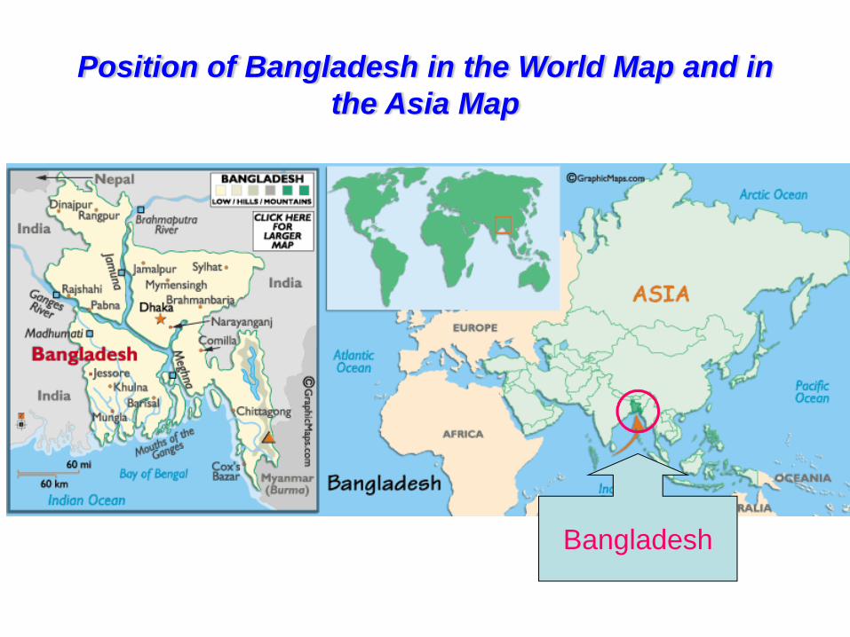
Position of Bangladesh in the World Map and in the Asia Map
Bangladesh
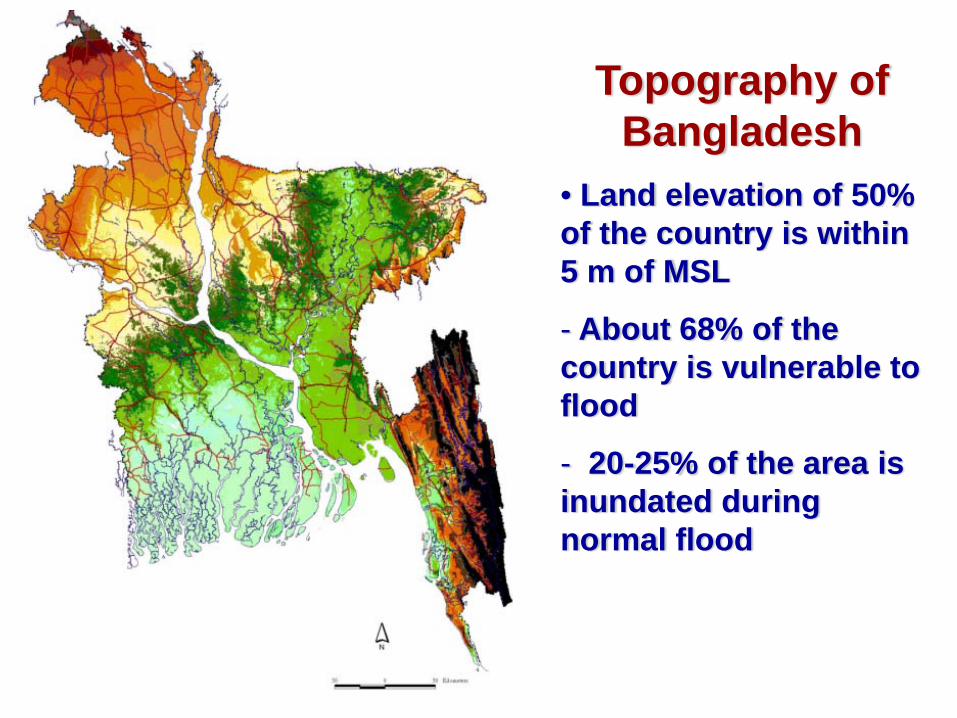
Topography of Bangladesh
• Land elevation of 50% of the country is within 5 m of MSL
- About 68% of the country is vulnerable to flood
- 20-25% of the area is inundated during normal flood
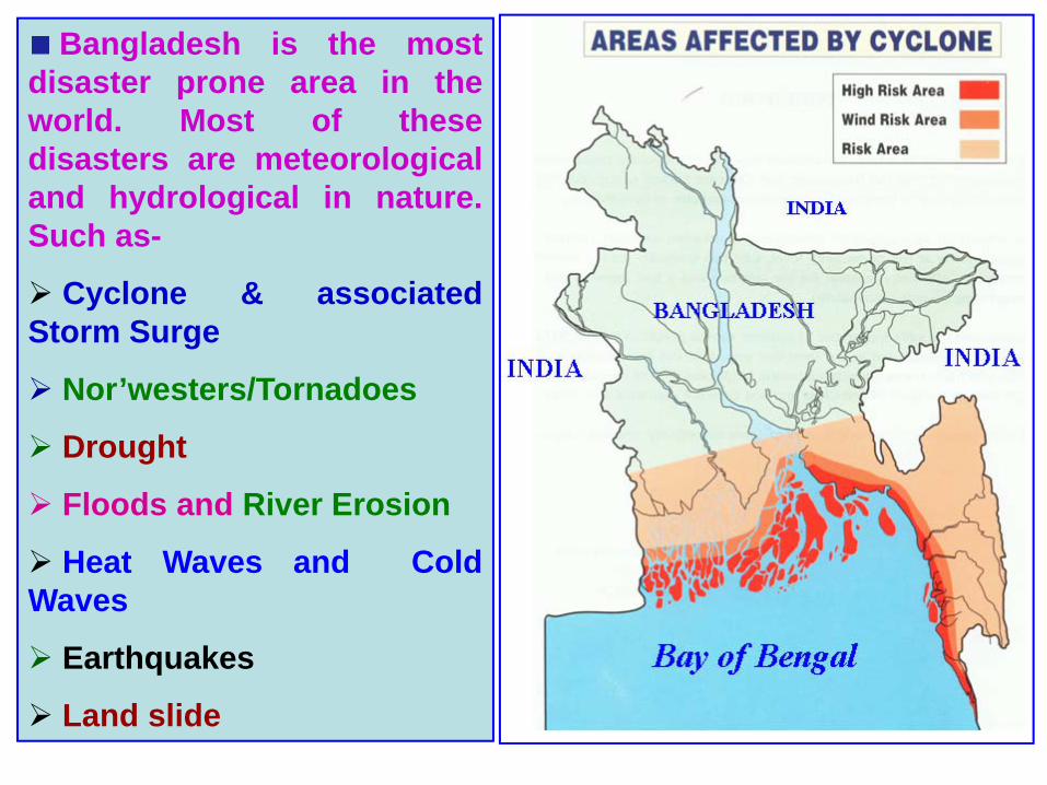
Bangladesh is the mostdisaster prone area in theworld. Most of thesedisasters are meteorologicaland hydrological in nature.Such as-
Cyclone & associatedStorm Surge
Nor’westers/Tornadoes
Drought
Floods and River Erosion
Heat Waves and ColdWaves
Earthquakes
Land slide
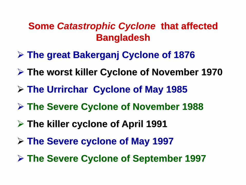
Some Catastrophic Cyclone that affected Bangladesh
The great Bakerganj Cyclone of 1876
The worst killer Cyclone of November 1970
The Urrirchar Cyclone of May 1985
The Severe Cyclone of November 1988
The killer cyclone of April 1991
The Severe cyclone of May 1997
The Severe Cyclone of September 1997
0.00
0.05
0.10
0.15
0.20
0.25
0.30
0.35
0.40
Jan Feb Mar Apr May Jun Jul Aug Sep Oct Nov Dec
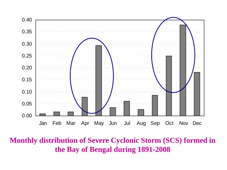
Monthly distribution of Severe Cyclonic Storm (SCS) formed in the Bay of Bengal during 1891-2008
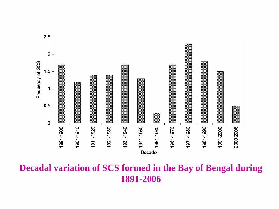
Decadal variation of SCS formed in the Bay of Bengal during 1891-2006
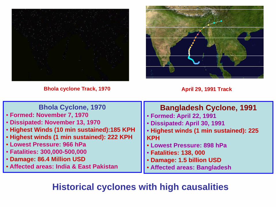
Bhola cyclone Track, 1970 April 29, 1991 Track
Bangladesh Cyclone, 1991• Formed: April 22, 1991 • Dissipated: April 30, 1991• Highest winds (1 min sustained): 225 KPH• Lowest Pressure: 898 hPa• Fatalities: 138, 000• Damage: 1.5 billion USD• Affected areas: Bangladesh
Bhola Cyclone, 1970• Formed: November 7, 1970• Dissipated: November 13, 1970• Highest Winds (10 min sustained):185 KPH• Highest winds (1 min sustained): 222 KPH• Lowest Pressure: 966 hPa• Fatalities: 300,000-500,000 • Damage: 86.4 Million USD• Affected areas: India & East Pakistan
Historical cyclones with high causalities
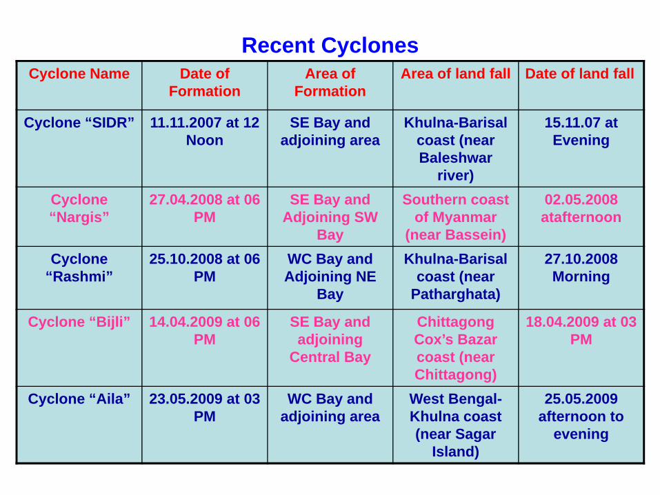
Recent CyclonesCyclone Name Date of
FormationArea of
FormationArea of land fall Date of land fall
Cyclone “SIDR” 11.11.2007 at 12 Noon
SE Bay and adjoining area
Khulna-Barisal coast (near Baleshwar
river)
15.11.07 at Evening
Cyclone “Nargis”
27.04.2008 at 06 PM
SE Bay and Adjoining SW
Bay
Southern coast of Myanmar
(near Bassein)
02.05.2008 atafternoon
Cyclone “Rashmi”
25.10.2008 at 06 PM
WC Bay and Adjoining NE
Bay
Khulna-Barisal coast (near
Patharghata)
27.10.2008 Morning
Cyclone “Bijli” 14.04.2009 at 06 PM
SE Bay and adjoining
Central Bay
Chittagong Cox’s Bazar coast (near Chittagong)
18.04.2009 at 03 PM
Cyclone “Aila” 23.05.2009 at 03 PM
WC Bay and adjoining area
West Bengal-Khulna coast (near Sagar
Island)
25.05.2009 afternoon to
evening
Cyclone Warning Systems in BangladeshBMD is responsible for providing tropical cyclone warnings. Warnings and forecasts are issued under the authority of the Director, BMD. The tropical storm warnings are provided from the Storm Warning Centre (SWC) of BMD which is located at Dhaka.The tropical cyclones are tracked with the help of conventional observations, radar and satellite observations and model derived products.After issuing the tropical cyclone warnings are provided to:
• The Hon’ble President• The Hon’ble Prime Minister• Control room, Ministry of Food and Disaster Management (MoFDM)• All ministries• Sea Port Authorities at Chittagong, Mongla and Cox’s Bazar• Cyclone Preparedness Programme (CPP), Bangladesh Red Crescent
Society• Armed Forces division, Bangladesh Navy, Bangladesh Air Force• Inland river ports authorities, Airport authorities• Concerned government officials• The general public (through Betar (Radio) Television, electronic media
and mass-media)• Fishing boats and trawlers in the sea, Coast Guard• Non-Government Organizations
Stages of warnings Warnings are issued in four stages for the government officials. The first
stage called "Alert" is issued to all concerned whenever a disturbance isdetected in the Bay as per SOD of Bangladesh. In the second stage,cyclone warnings are issued in four steps as detailed below:
a. Distant Cautionary Signal is issued if a ship might run into danger duringits voyage after leaving the harbour. Distant Warning Signal issued whenthere is no immediate danger of the port but a ship might run into thestorm after leaving the port.
b. Local Cautionary Signal is issued when the port is threatened by squallyweather from tropical disturbances.
c. Local Warning Signal is issued when the port is threatened by a storm, butit does not appear that the danger is as yet sufficiently great to justifyextreme measures of precaution. It is issued minimum 24 hours beforethe landfall.
d. Danger Signal is issued when the port is likely to experience severeweather from a storm of slight or moderate intensity. The Signal is issuedminimum 18 hours before the landfall.
e. Great Danger Signal is issued when the port is likely to experience severeweather from a storm of great intensity. The signal is issued minimum 10hours before the landfall.
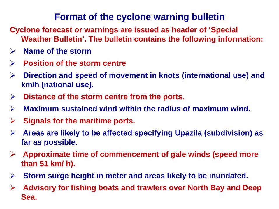
Format of the cyclone warning bulletinCyclone forecast or warnings are issued as header of ‘Special
Weather Bulletin’. The bulletin contains the following information:Name of the stormPosition of the storm centreDirection and speed of movement in knots (international use) and km/h (national use).Distance of the storm centre from the ports.Maximum sustained wind within the radius of maximum wind.Signals for the maritime ports.Areas are likely to be affected specifying Upazila (subdivision) as far as possible.Approximate time of commencement of gale winds (speed more than 51 km/ h).Storm surge height in meter and areas likely to be inundated.Advisory for fishing boats and trawlers over North Bay and Deep Sea.
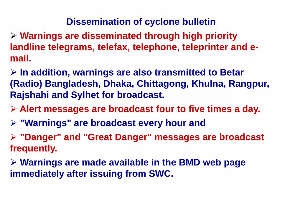
Dissemination of cyclone bulletinWarnings are disseminated through high priority
landline telegrams, telefax, telephone, teleprinter and e-mail.
In addition, warnings are also transmitted to Betar (Radio) Bangladesh, Dhaka, Chittagong, Khulna, Rangpur, Rajshahi and Sylhet for broadcast.
Alert messages are broadcast four to five times a day."Warnings" are broadcast every hour and"Danger" and "Great Danger" messages are broadcast
frequently. Warnings are made available in the BMD web page
immediately after issuing from SWC.
Some hazardous scenario in Bangladesh
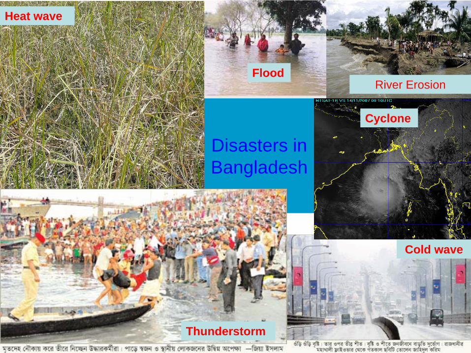
River ErosionFlood
Disasters in Bangladesh
Heat wave
Cold wave
Thunderstorm
Cyclone
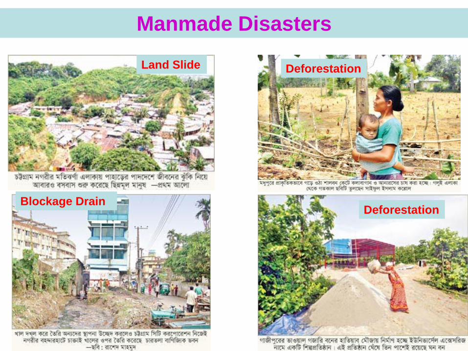
Manmade Disasters
Land Slide Deforestation
DeforestationBlockage Drain
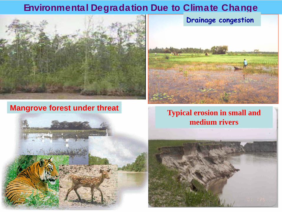
Environmental Degradation Due to Climate Change
Mangrove forest under threat
Drainage congestion
Typical erosion in small and medium rivers
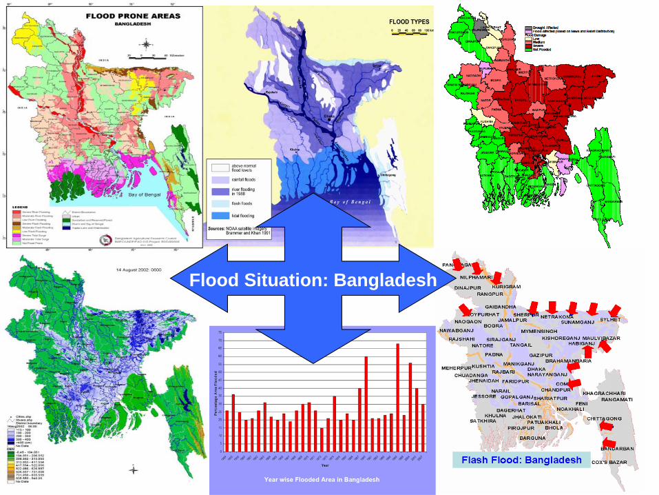
Flood Situation: Bangladesh
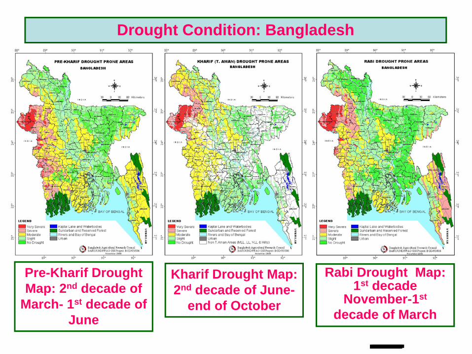
Pre-Kharif Drought Map: 2nd decade of
March- 1st decade of June
Kharif Drought Map: 2nd decade of June-
end of October
Rabi Drought Map: 1st decade
November-1st
decade of March
Drought Condition: Bangladesh
Monitoring cyclone SIDR
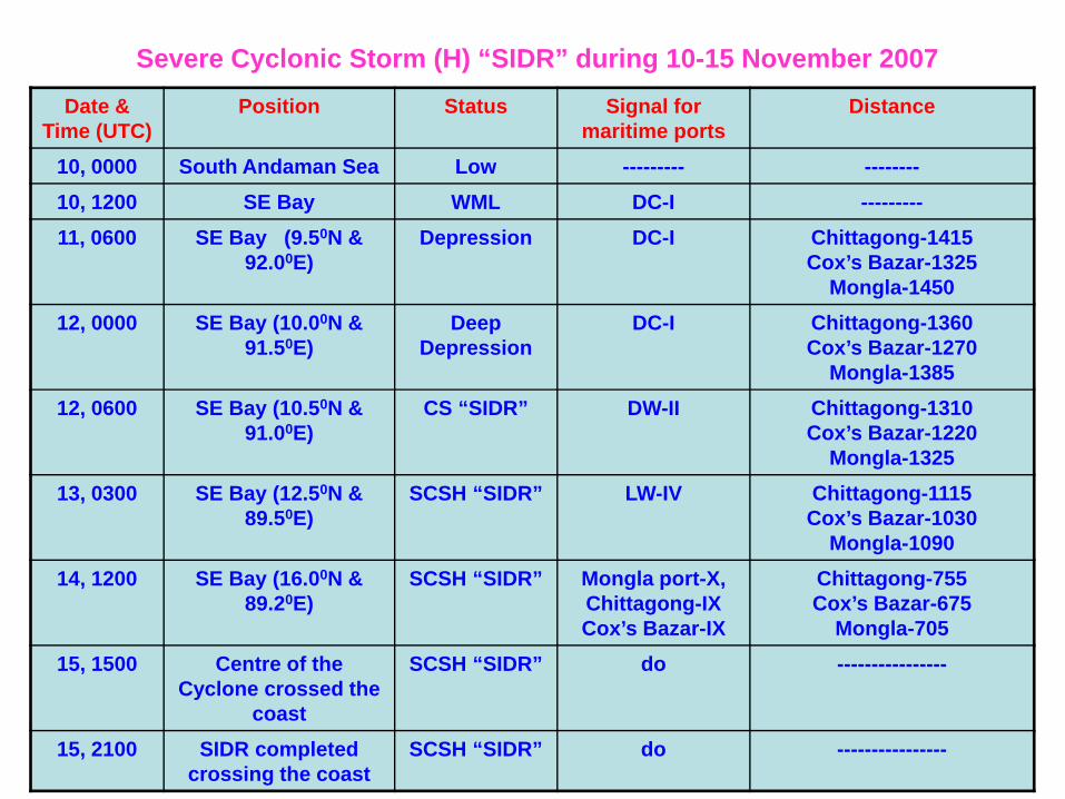
Date & Time (UTC)
Position Status Signal for maritime ports
Distance
10, 0000 South Andaman Sea Low --------- --------10, 1200 SE Bay WML DC-I ---------11, 0600 SE Bay (9.50N &
92.00E)Depression DC-I Chittagong-1415
Cox’s Bazar-1325Mongla-1450
12, 0000 SE Bay (10.00N & 91.50E)
Deep Depression
DC-I Chittagong-1360Cox’s Bazar-1270
Mongla-138512, 0600 SE Bay (10.50N &
91.00E)CS “SIDR” DW-II Chittagong-1310
Cox’s Bazar-1220Mongla-1325
13, 0300 SE Bay (12.50N & 89.50E)
SCSH “SIDR” LW-IV Chittagong-1115Cox’s Bazar-1030
Mongla-109014, 1200 SE Bay (16.00N &
89.20E)SCSH “SIDR” Mongla port-X,
Chittagong-IX Cox’s Bazar-IX
Chittagong-755Cox’s Bazar-675
Mongla-70515, 1500 Centre of the
Cyclone crossed the coast
SCSH “SIDR” do ----------------
15, 2100 SIDR completed crossing the coast
SCSH “SIDR” do ----------------
Severe Cyclonic Storm (H) “SIDR” during 10-15 November 2007
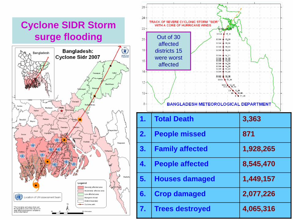
Cyclone SIDR Storm surge flooding Out of 30
affected districts 15 were worst
affected
1. Total Death 3,363
2. People missed 871
3. Family affected 1,928,265
4. People affected 8,545,470
5. Houses damaged 1,449,157
6. Crop damaged 2,077,226
7. Trees destroyed 4,065,316
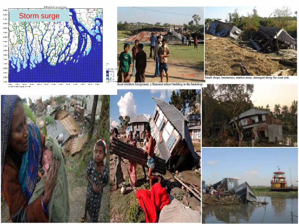
Storm surge
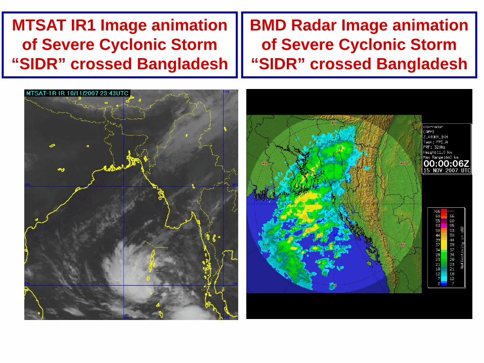
MTSAT IR1 Image animation of Severe Cyclonic Storm
“SIDR” crossed Bangladesh
BMD Radar Image animation of Severe Cyclonic Storm
“SIDR” crossed Bangladesh
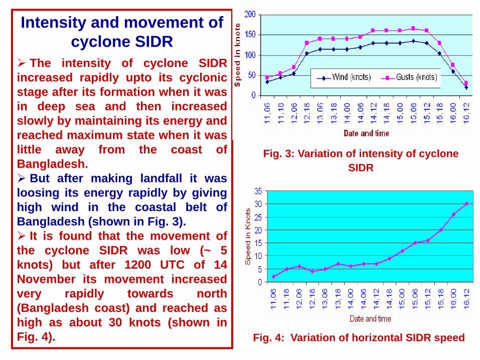
Intensity and movement of cyclone SIDR
The intensity of cyclone SIDRincreased rapidly upto its cyclonicstage after its formation when it wasin deep sea and then increasedslowly by maintaining its energy andreached maximum state when it waslittle away from the coast ofBangladesh.
But after making landfall it wasloosing its energy rapidly by givinghigh wind in the coastal belt ofBangladesh (shown in Fig. 3).
It is found that the movement ofthe cyclone SIDR was low (~ 5knots) but after 1200 UTC of 14November its movement increasedvery rapidly towards north(Bangladesh coast) and reached ashigh as about 30 knots (shown inFig. 4).
Fig. 3: Variation of intensity of cyclone SIDR
Fig. 4: Variation of horizontal SIDR speed
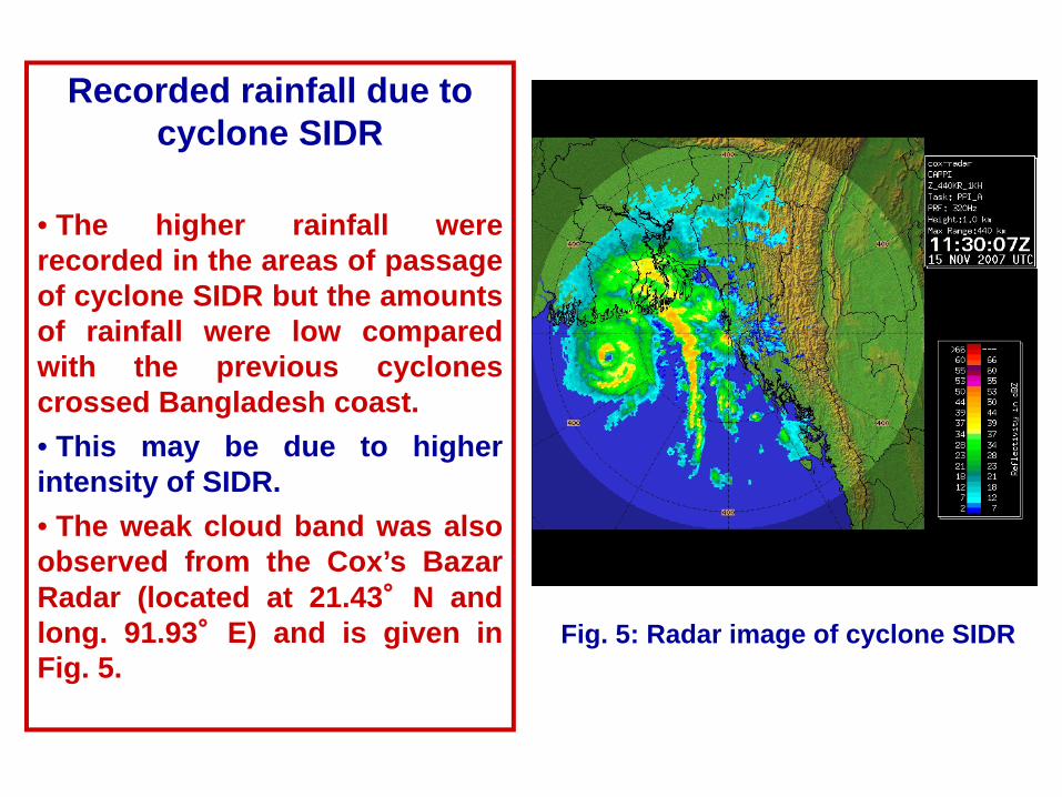
Recorded rainfall due to cyclone SIDR
• The higher rainfall wererecorded in the areas of passageof cyclone SIDR but the amountsof rainfall were low comparedwith the previous cyclonescrossed Bangladesh coast.• This may be due to higherintensity of SIDR.• The weak cloud band was alsoobserved from the Cox’s BazarRadar (located at 21.43°N andlong. 91.93°E) and is given inFig. 5.
Fig. 5: Radar image of cyclone SIDR
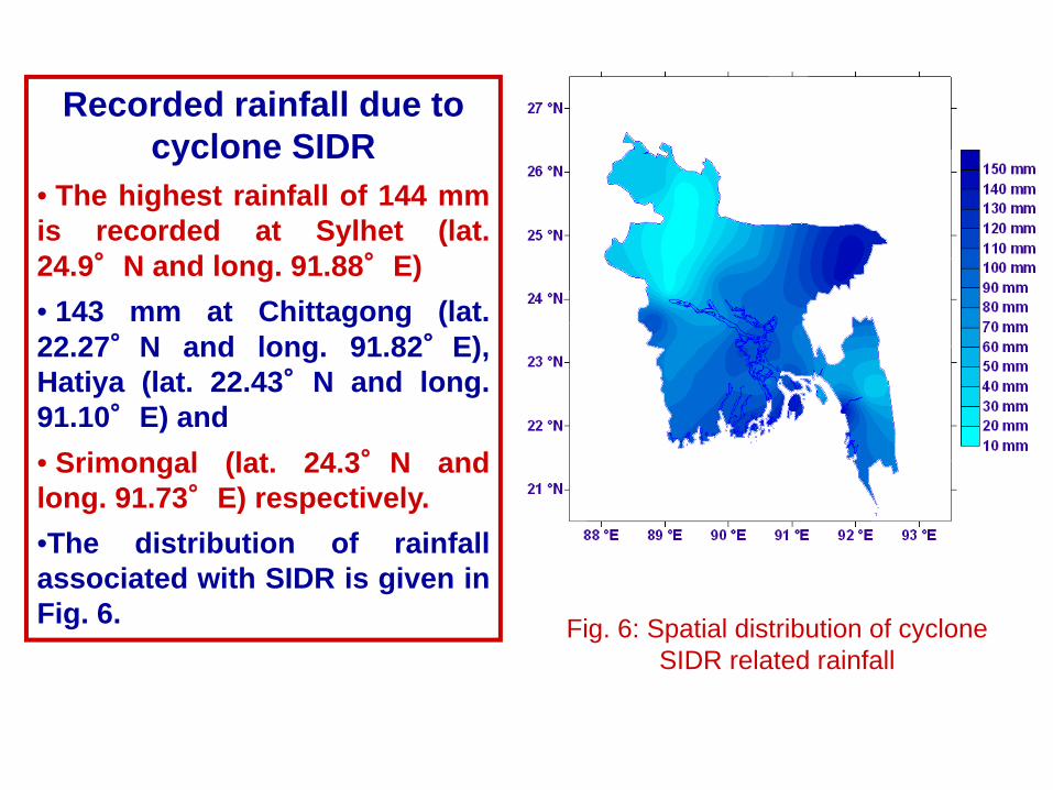
Recorded rainfall due to cyclone SIDR
• The highest rainfall of 144 mmis recorded at Sylhet (lat.24.9°N and long. 91.88°E)• 143 mm at Chittagong (lat.22.27°N and long. 91.82°E),Hatiya (lat. 22.43°N and long.91.10°E) and• Srimongal (lat. 24.3°N andlong. 91.73°E) respectively.•The distribution of rainfallassociated with SIDR is given inFig. 6. Fig. 6: Spatial distribution of cyclone
SIDR related rainfall
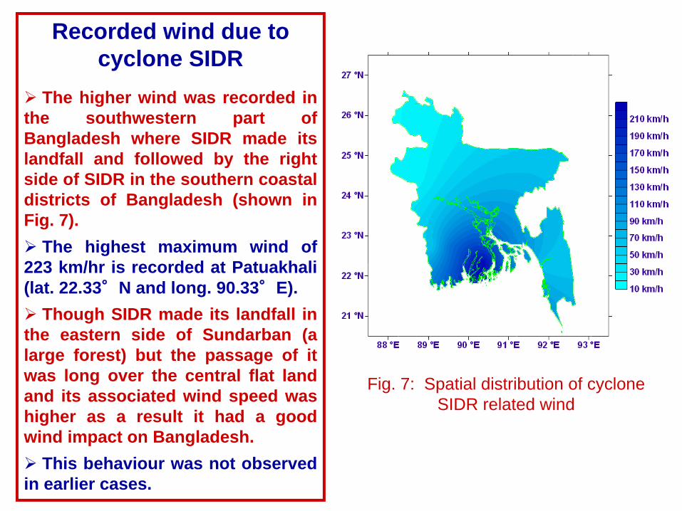
Recorded wind due to cyclone SIDR
The higher wind was recorded inthe southwestern part ofBangladesh where SIDR made itslandfall and followed by the rightside of SIDR in the southern coastaldistricts of Bangladesh (shown inFig. 7).
The highest maximum wind of223 km/hr is recorded at Patuakhali(lat. 22.33°N and long. 90.33°E).
Though SIDR made its landfall inthe eastern side of Sundarban (alarge forest) but the passage of itwas long over the central flat landand its associated wind speed washigher as a result it had a goodwind impact on Bangladesh.
This behaviour was not observedin earlier cases.
Fig. 7: Spatial distribution of cyclone SIDR related wind
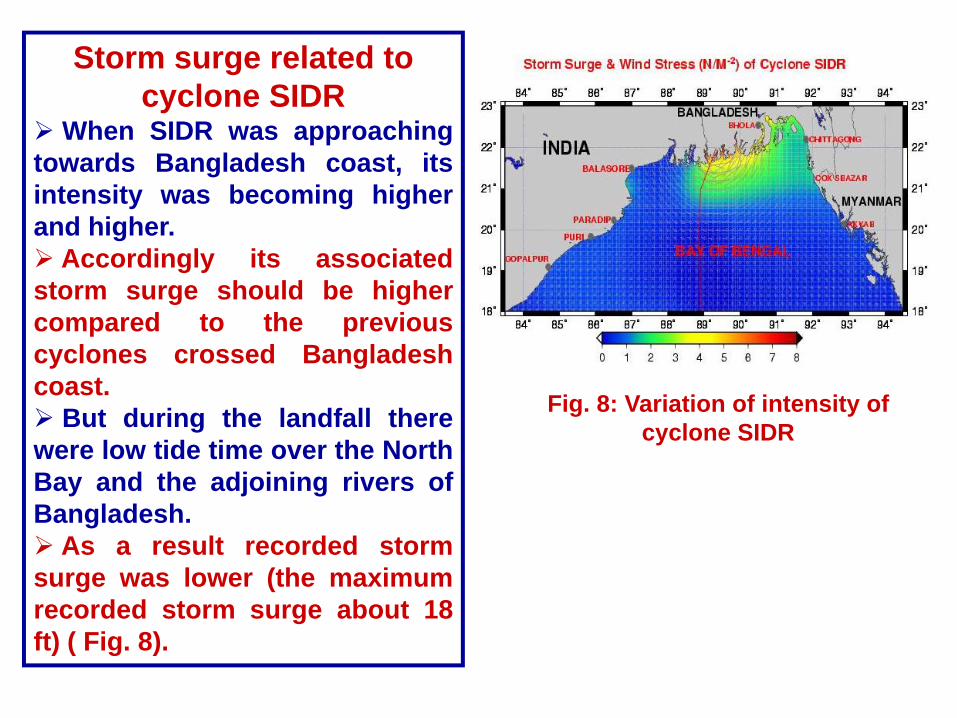
Storm surge related to cyclone SIDR
When SIDR was approachingtowards Bangladesh coast, itsintensity was becoming higherand higher.
Accordingly its associatedstorm surge should be highercompared to the previouscyclones crossed Bangladeshcoast.
But during the landfall therewere low tide time over the NorthBay and the adjoining rivers ofBangladesh.
As a result recorded stormsurge was lower (the maximumrecorded storm surge about 18ft) ( Fig. 8).
Fig. 8: Variation of intensity of cyclone SIDR
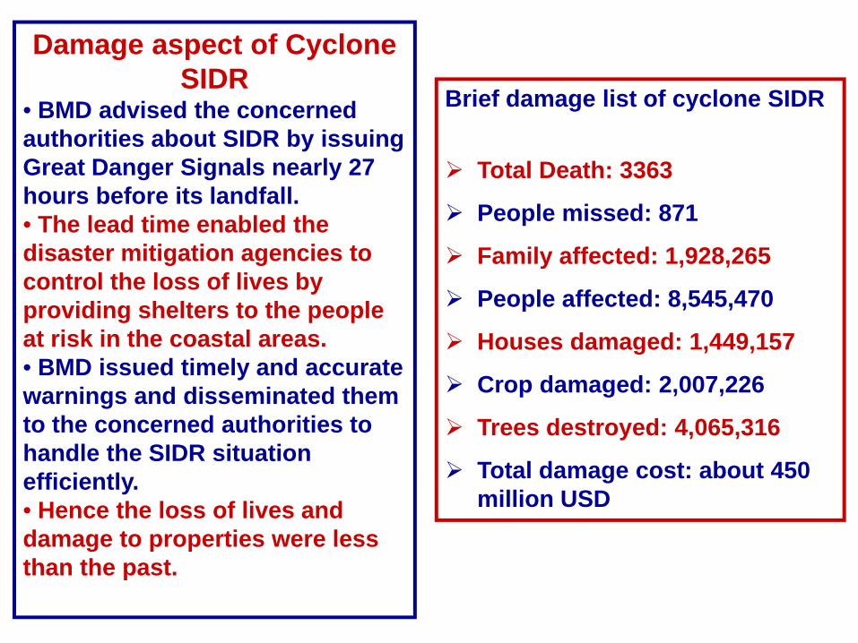
Damage aspect of Cyclone SIDR
• BMD advised the concerned authorities about SIDR by issuing Great Danger Signals nearly 27 hours before its landfall.• The lead time enabled the disaster mitigation agencies to control the loss of lives by providing shelters to the people at risk in the coastal areas.• BMD issued timely and accurate warnings and disseminated them to the concerned authorities to handle the SIDR situation efficiently.• Hence the loss of lives and damage to properties were less than the past.
Brief damage list of cyclone SIDR
Total Death: 3363
People missed: 871
Family affected: 1,928,265
People affected: 8,545,470
Houses damaged: 1,449,157
Crop damaged: 2,007,226
Trees destroyed: 4,065,316
Total damage cost: about 450 million USD
Method of disaster management aspect related to cyclone SIDR
On 13 November, when the System turned into a SCS (H) maritime ports were advised to hoist Warning Signal Number Four and all fishing boats and trawlers over North Bay were advised to take shelter immediately.
A meeting of NDMC was held immediately after hoisting SignalNumber Four. In that meeting all the concerned authorities wereinstructed to take the necessary steps according to SOD
The Armed Forces Division (AFD) and government officials werealso placed on standby.
Several central control rooms were activated by various agenciesat national, district and upazila levels while the DMIC was opened.
A series of meetings and arrangements were in place to quicklymobilize staff and resources.
At 9 PM on 14 November 2007, SIDR was centered about 725 km South-southwest of Chittagong port, 645 km South-southwest of Cox’s Bazar portand 670 km South of Mongla port.
Method of disaster management aspect related to cyclone SIDR continue ….
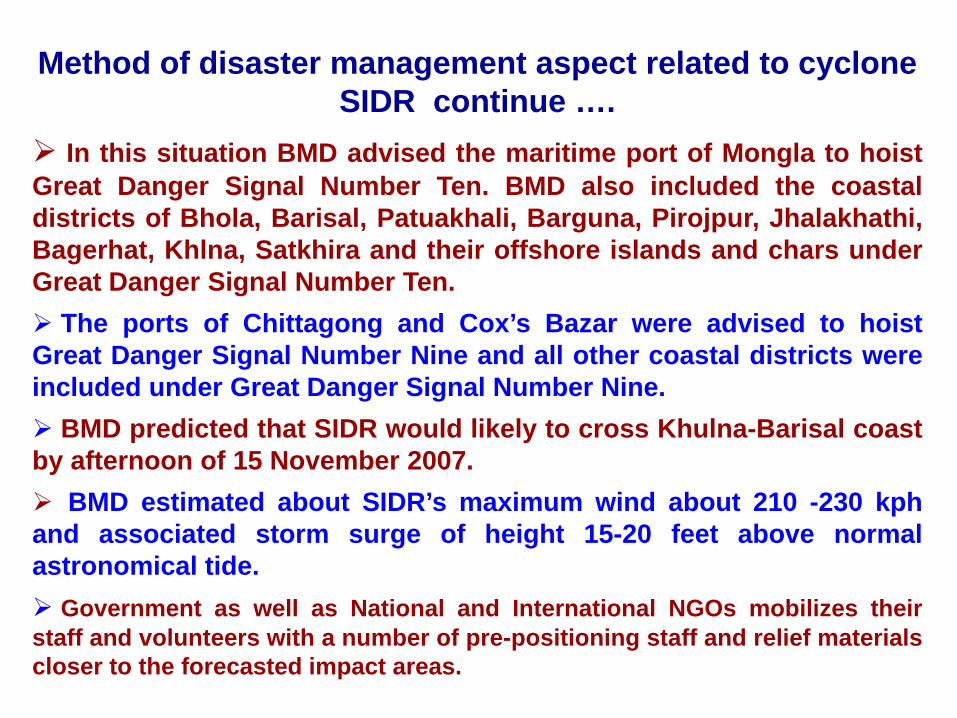
In this situation BMD advised the maritime port of Mongla to hoistGreat Danger Signal Number Ten. BMD also included the coastaldistricts of Bhola, Barisal, Patuakhali, Barguna, Pirojpur, Jhalakhathi,Bagerhat, Khlna, Satkhira and their offshore islands and chars underGreat Danger Signal Number Ten.
The ports of Chittagong and Cox’s Bazar were advised to hoistGreat Danger Signal Number Nine and all other coastal districts wereincluded under Great Danger Signal Number Nine.
BMD predicted that SIDR would likely to cross Khulna-Barisal coastby afternoon of 15 November 2007.
BMD estimated about SIDR’s maximum wind about 210 -230 kphand associated storm surge of height 15-20 feet above normalastronomical tide.
Government as well as National and International NGOs mobilizes theirstaff and volunteers with a number of pre-positioning staff and relief materialscloser to the forecasted impact areas.
Method of disaster management aspect related to cyclone SIDR continue ….
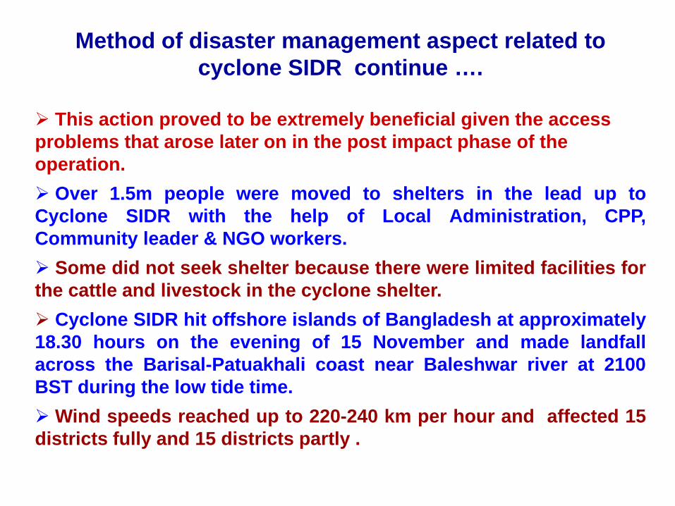
This action proved to be extremely beneficial given the access problems that arose later on in the post impact phase of the operation.
Over 1.5m people were moved to shelters in the lead up toCyclone SIDR with the help of Local Administration, CPP,Community leader & NGO workers.
Some did not seek shelter because there were limited facilities forthe cattle and livestock in the cyclone shelter.
Cyclone SIDR hit offshore islands of Bangladesh at approximately18.30 hours on the evening of 15 November and made landfallacross the Barisal-Patuakhali coast near Baleshwar river at 2100BST during the low tide time.
Wind speeds reached up to 220-240 km per hour and affected 15districts fully and 15 districts partly .
Monitoring cyclone AILA
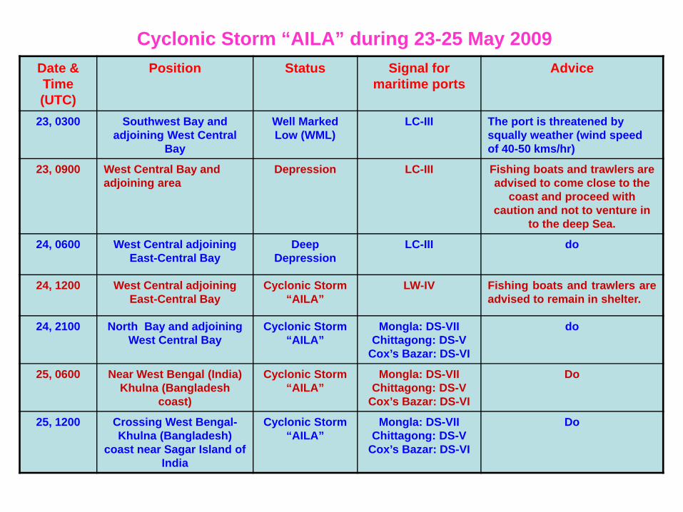
Date & Time (UTC)
Position Status Signal for maritime ports
Advice
23, 0300 Southwest Bay and adjoining West Central
Bay
Well Marked Low (WML)
LC-III The port is threatened by squally weather (wind speed of 40-50 kms/hr)
23, 0900 West Central Bay and adjoining area
Depression LC-III Fishing boats and trawlers are advised to come close to the
coast and proceed with caution and not to venture in
to the deep Sea.
24, 0600 West Central adjoining East-Central Bay
Deep Depression
LC-III do
24, 1200 West Central adjoining East-Central Bay
Cyclonic Storm “AILA”
LW-IV Fishing boats and trawlers areadvised to remain in shelter.
24, 2100 North Bay and adjoining West Central Bay
Cyclonic Storm “AILA”
Mongla: DS-VII Chittagong: DS-V
Cox’s Bazar: DS-VI
do
25, 0600 Near West Bengal (India) Khulna (Bangladesh
coast)
Cyclonic Storm “AILA”
Mongla: DS-VII Chittagong: DS-V
Cox’s Bazar: DS-VI
Do
25, 1200 Crossing West Bengal-Khulna (Bangladesh)
coast near Sagar Island of India
Cyclonic Storm “AILA”
Mongla: DS-VII Chittagong: DS-V
Cox’s Bazar: DS-VI
Do
Cyclonic Storm “AILA” during 23-25 May 2009
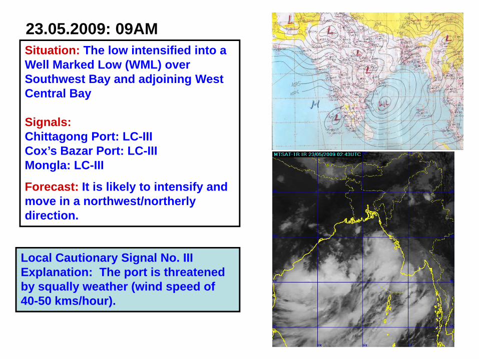
23.05.2009: 09AM Situation: The low intensified into a Well Marked Low (WML) over Southwest Bay and adjoining West Central Bay
Signals:Chittagong Port: LC-IIICox’s Bazar Port: LC-IIIMongla: LC-III
Forecast: It is likely to intensify and move in a northwest/northerly direction.
Local Cautionary Signal No. IIIExplanation: The port is threatened by squally weather (wind speed of 40-50 kms/hour).
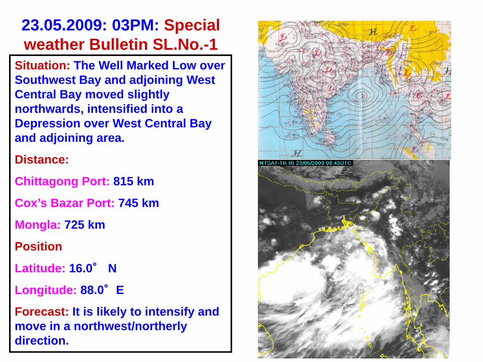
23.05.2009: 03PM: Special weather Bulletin SL.No.-1
Situation: The Well Marked Low over Southwest Bay and adjoining West Central Bay moved slightly northwards, intensified into a Depression over West Central Bay and adjoining area.
Distance:
Chittagong Port: 815 km
Cox’s Bazar Port: 745 km
Mongla: 725 km
Position
Latitude: 16.0° N
Longitude: 88.0°E
Forecast: It is likely to intensify and move in a northwest/northerly direction.
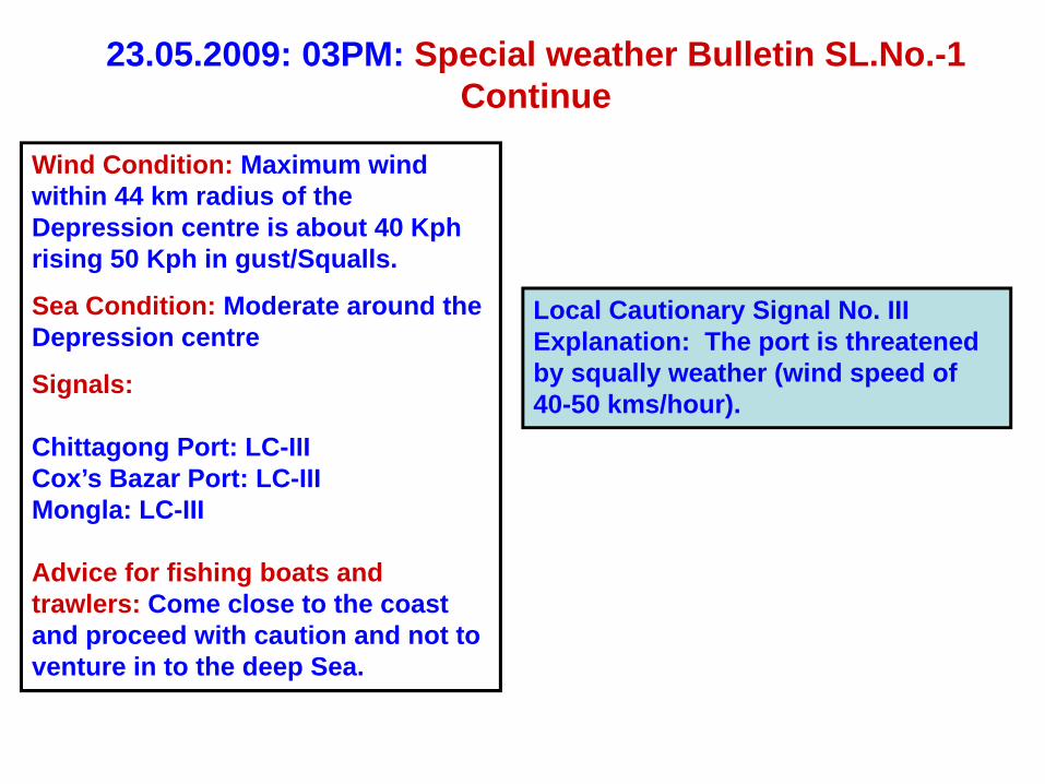
23.05.2009: 03PM: Special weather Bulletin SL.No.-1 Continue
Wind Condition: Maximum wind within 44 km radius of the Depression centre is about 40 Kph rising 50 Kph in gust/Squalls.
Sea Condition: Moderate around the Depression centre
Signals:
Chittagong Port: LC-IIICox’s Bazar Port: LC-IIIMongla: LC-III
Advice for fishing boats and trawlers: Come close to the coast and proceed with caution and not to venture in to the deep Sea.
Local Cautionary Signal No. IIIExplanation: The port is threatened by squally weather (wind speed of 40-50 kms/hour).
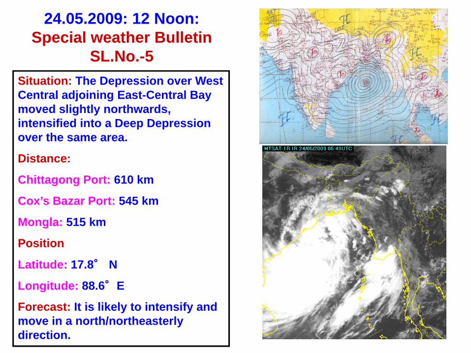
24.05.2009: 12 Noon:Special weather Bulletin
SL.No.-5Situation: The Depression over West Central adjoining East-Central Bay moved slightly northwards, intensified into a Deep Depression over the same area.
Distance:
Chittagong Port: 610 km
Cox’s Bazar Port: 545 km
Mongla: 515 km
Position
Latitude: 17.8° N
Longitude: 88.6°E
Forecast: It is likely to intensify and move in a north/northeasterly direction.
24.05.2009: 12 Noon: Special weather Bulletin SL.No.-5 Continue
Wind Condition: Maximum wind within 48 km radius of the Depression centre is about 50 Kph rising 60 Kph in gust/Squalls.
Sea Condition: Rough around the Deep Depression centre.
Signals:
Chittagong Port: LC-IIICox’s Bazar Port: LC-IIIMongla: LC-III
Advice for fishing boats and trawlers: Come close to the coast and proceed with caution and not to venture in to the deep Sea.
Local Cautionary Signal No. IIIExplanation: The port is threatened by squally weather (wind speed of 40-50 kms/hour).
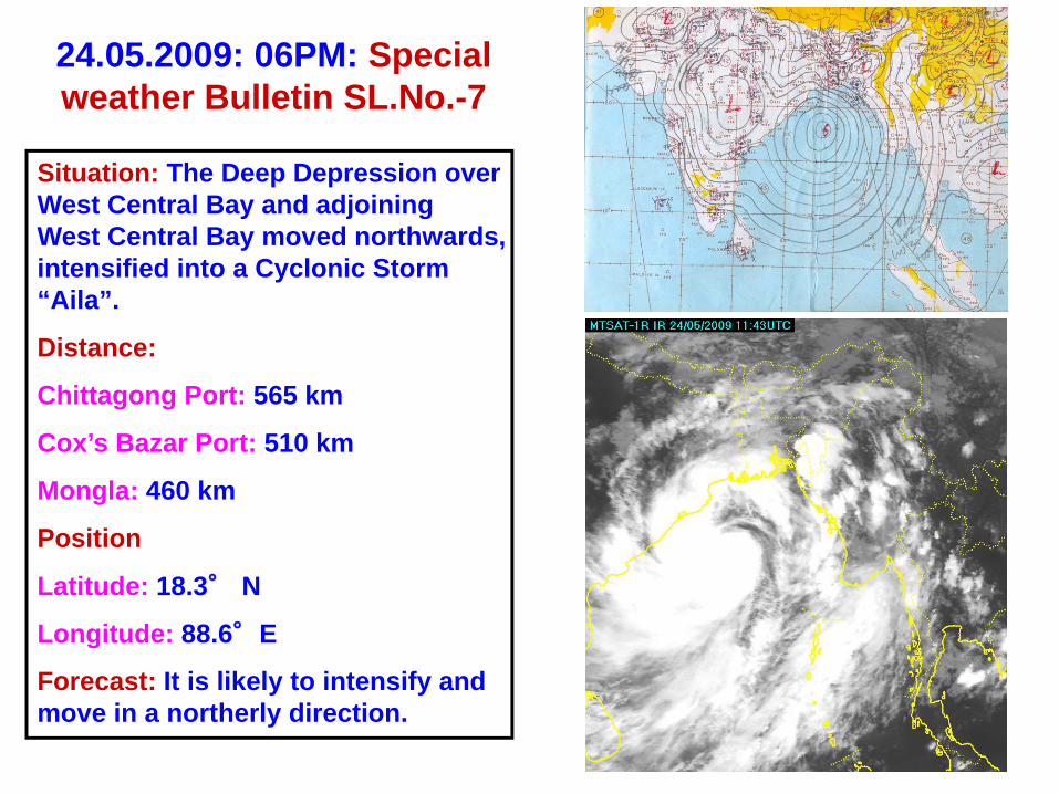
24.05.2009: 06PM: Special weather Bulletin SL.No.-7
Situation: The Deep Depression over West Central Bay and adjoining West Central Bay moved northwards, intensified into a Cyclonic Storm “Aila”.
Distance:
Chittagong Port: 565 km
Cox’s Bazar Port: 510 km
Mongla: 460 km
Position
Latitude: 18.3° N
Longitude: 88.6°E
Forecast: It is likely to intensify and move in a northerly direction.
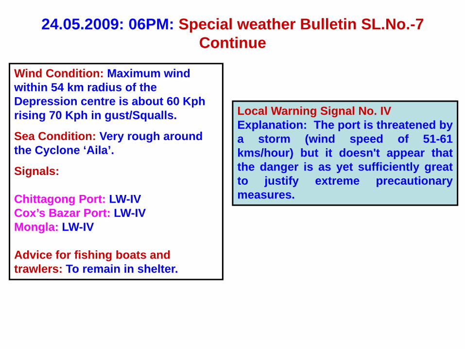
24.05.2009: 06PM: Special weather Bulletin SL.No.-7 Continue
Wind Condition: Maximum wind within 54 km radius of the Depression centre is about 60 Kph rising 70 Kph in gust/Squalls.
Sea Condition: Very rough around the Cyclone ‘Aila’.
Signals:
Chittagong Port: LW-IVCox’s Bazar Port: LW-IVMongla: LW-IV
Advice for fishing boats and trawlers: To remain in shelter.
Local Warning Signal No. IVExplanation: The port is threatened bya storm (wind speed of 51-61kms/hour) but it doesn't appear thatthe danger is as yet sufficiently greatto justify extreme precautionarymeasures.
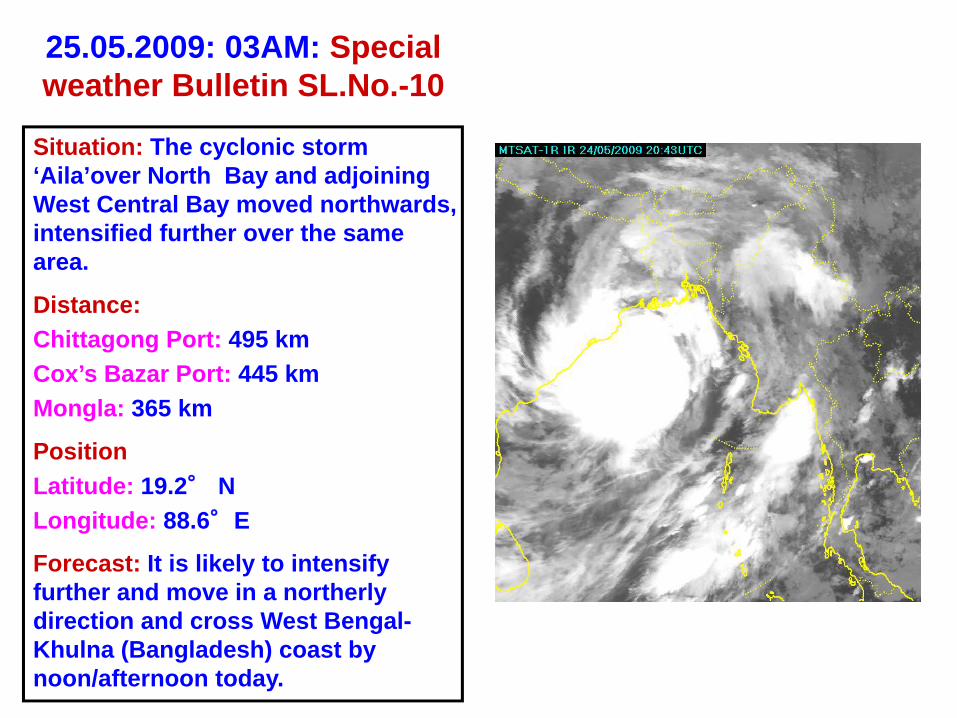
25.05.2009: 03AM: Special weather Bulletin SL.No.-10
Situation: The cyclonic storm ‘Aila’over North Bay and adjoining West Central Bay moved northwards, intensified further over the same area.
Distance:Chittagong Port: 495 kmCox’s Bazar Port: 445 kmMongla: 365 km
PositionLatitude: 19.2° NLongitude: 88.6°E
Forecast: It is likely to intensify further and move in a northerly direction and cross West Bengal-Khulna (Bangladesh) coast by noon/afternoon today.
25.05.2009: 03AM: Special weather Bulletin SL.No.-10 Continue
Wind Condition: Maximum wind within 54 km radius of the Depression centre is about 70 Kph rising 90 Kph in gust/Squalls.
Sea Condition: Very rough around the Cyclone ‘Aila’.
Tidal condition: Storm surge of 05-07 above normal astronomical tide
Signals:
Mongla: DS-VIIChittagong Port: DS -VICox’s Bazar Port: DS -VI
Advice for fishing boats and trawlers: To remain in shelter.
Danger Signal No. VIIExplanation: The port will experiencesevere weather from a storm of lightor moderate intensity (wind speed of62-88 kms/hour) that is expected tocross over or near the port.
Danger Signal No. VIExplanation: The port will experiencesevere weather from a storm of slightor moderate intensity (wind speed of62-88 kms/hour) that is expected tocross the coast in the left side of theport.
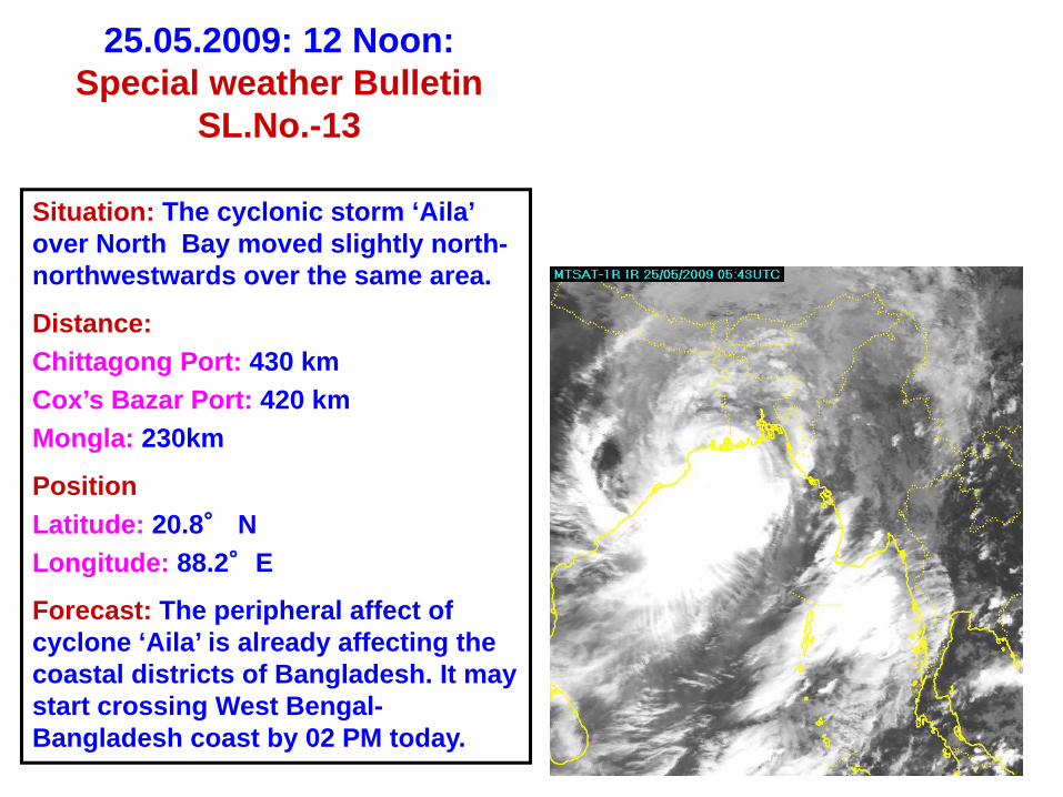
25.05.2009: 12 Noon:Special weather Bulletin
SL.No.-13
Situation: The cyclonic storm ‘Aila’ over North Bay moved slightly north-northwestwards over the same area.
Distance:Chittagong Port: 430 kmCox’s Bazar Port: 420 kmMongla: 230km
PositionLatitude: 20.8° NLongitude: 88.2°E
Forecast: The peripheral affect of cyclone ‘Aila’ is already affecting the coastal districts of Bangladesh. It may start crossing West Bengal-Bangladesh coast by 02 PM today.
25.05.2009: 12 Noon: Special weather Bulletin SL.No.-13 Continue
Wind Condition: Maximum wind within 54 km radius of the Depression centre is about 70 Kph rising 90 Kph in gust/Squalls.
Sea Condition: Very rough around the Cyclone ‘Aila’.
Tidal condition: Storm surge of 06-08 ft above normal astronomical tide
Signals:
Mongla: DS-VIIChittagong Port: DS -VICox’s Bazar Port: DS -VI
Advice for fishing boats and trawlers: To remain in shelter.
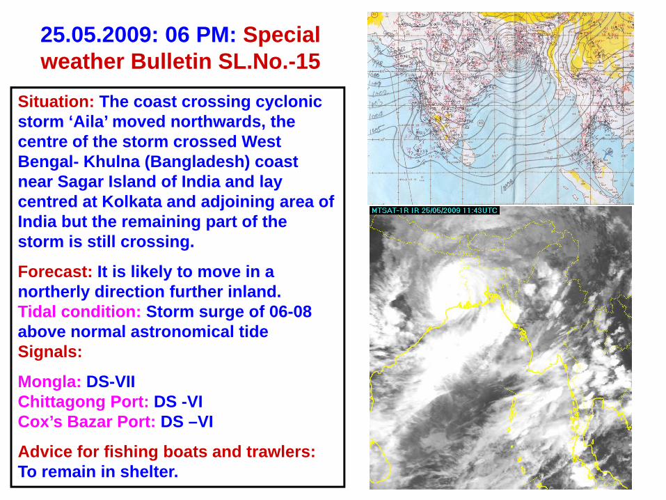
25.05.2009: 06 PM: Special weather Bulletin SL.No.-15
Situation: The coast crossing cyclonic storm ‘Aila’ moved northwards, the centre of the storm crossed West Bengal- Khulna (Bangladesh) coast near Sagar Island of India and lay centred at Kolkata and adjoining area of India but the remaining part of the storm is still crossing.
Forecast: It is likely to move in a northerly direction further inland. Tidal condition: Storm surge of 06-08 above normal astronomical tideSignals:
Mongla: DS-VIIChittagong Port: DS -VICox’s Bazar Port: DS –VI
Advice for fishing boats and trawlers:To remain in shelter.
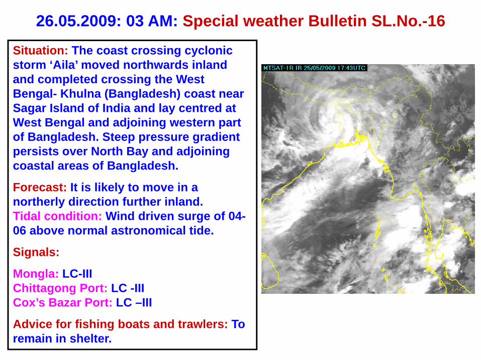
26.05.2009: 03 AM: Special weather Bulletin SL.No.-16
Situation: The coast crossing cyclonic storm ‘Aila’ moved northwards inland and completed crossing the West Bengal- Khulna (Bangladesh) coast near Sagar Island of India and lay centred at West Bengal and adjoining western part of Bangladesh. Steep pressure gradient persists over North Bay and adjoining coastal areas of Bangladesh.
Forecast: It is likely to move in a northerly direction further inland. Tidal condition: Wind driven surge of 04-06 above normal astronomical tide.
Signals:
Mongla: LC-IIIChittagong Port: LC -IIICox’s Bazar Port: LC –III
Advice for fishing boats and trawlers: To remain in shelter.
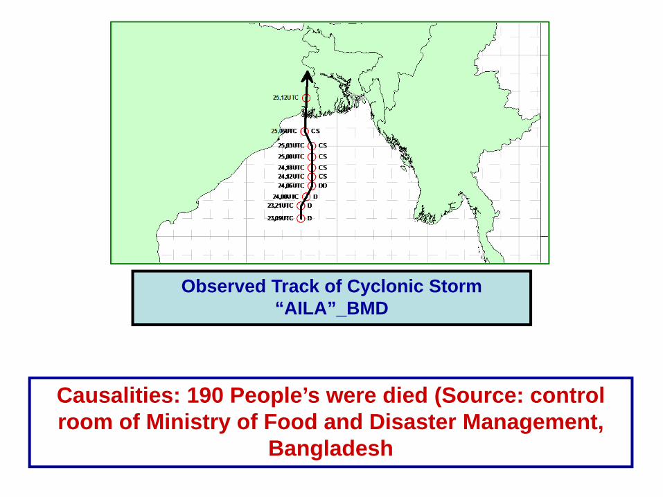
Observed Track of Cyclonic Storm “AILA”_BMD
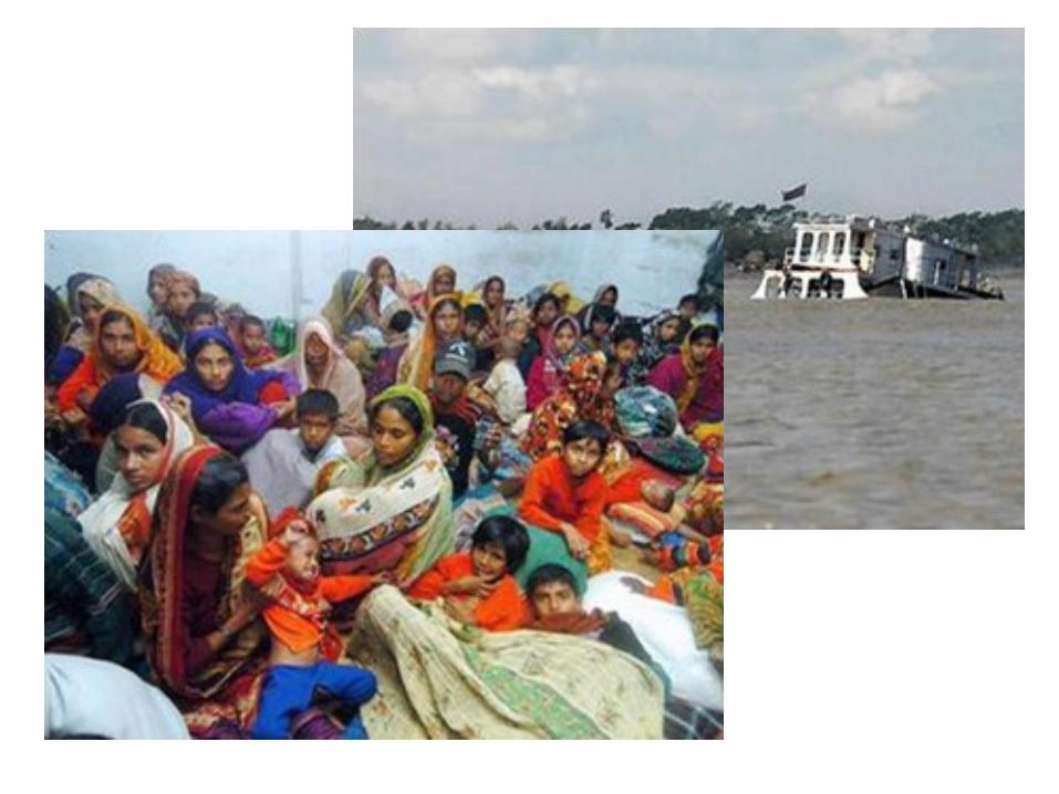
Causalities: 190 People’s were died (Source: control room of Ministry of Food and Disaster Management,
Bangladesh
Activities for Disaster Management related to Cyclone AILA
Considering the vulnerability in the Bay of Bengal and coastalareas of Bangladesh BMD issued the Local Cautionary signal no. 3for the maritime ports at 0300UTC of 23 May 2009 and advised thefishermen engaged in fishing over there to come close to the coastand proceed carefully and not to venture into the deep sea.
After that BMD carefully observed it and continued hoistedwarning signals no. 3.
Prior to the hoisting of signal no. 4 BMD opined in the Inter-ministerial Disaster Management Coordination Committee held atMoFDM in the afternoon of 24 May that the system could beconcentrated into a cyclonic storm at night time of the same dayand explained the related hazards in the coastal areas ofBangladesh.
At 1200UTC of 24 May when the system intensified into acyclonic storm “AILA”.
According to the forecast the wind driven surge height was also4.5 feet above normal astronomical tide during the landfall ofcyclone “AILA’.
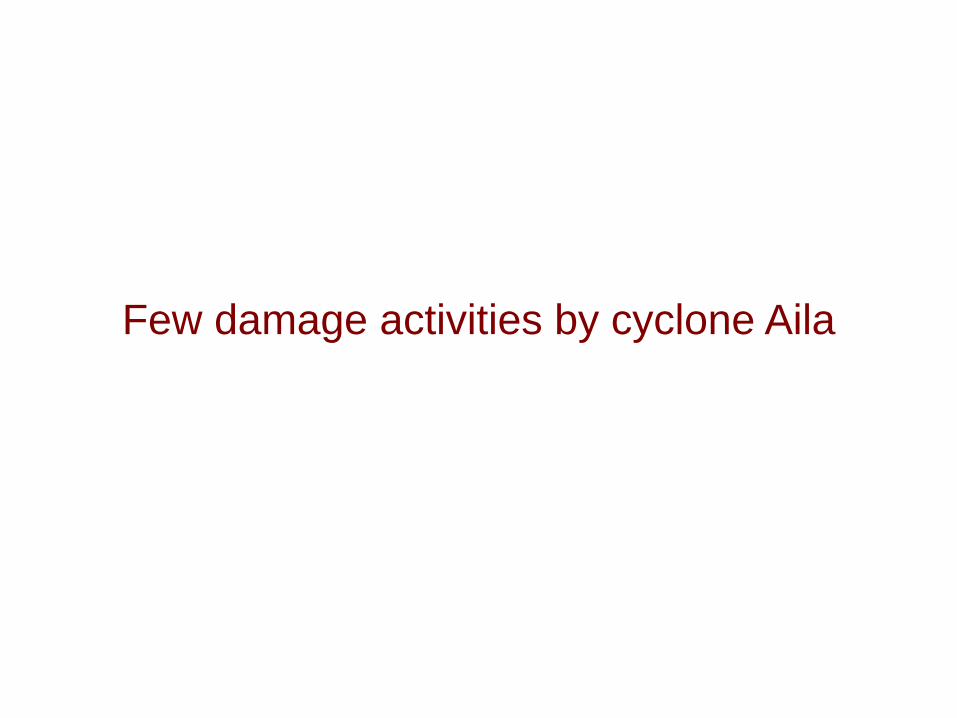
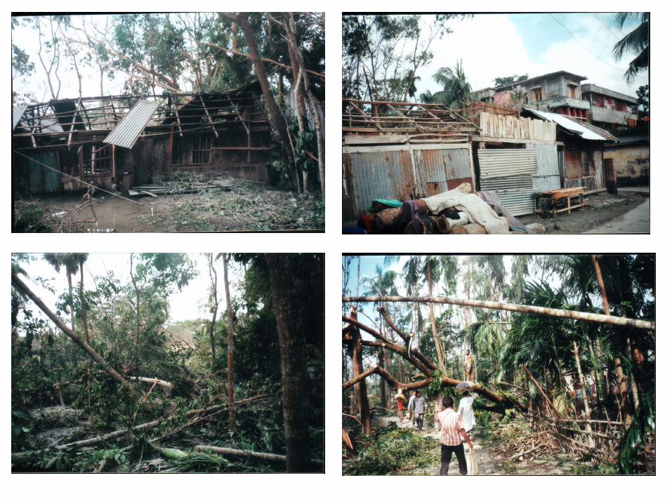
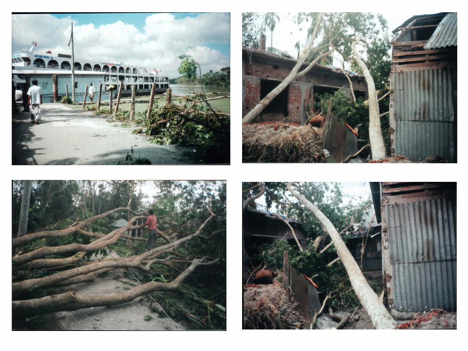
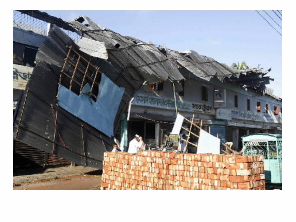
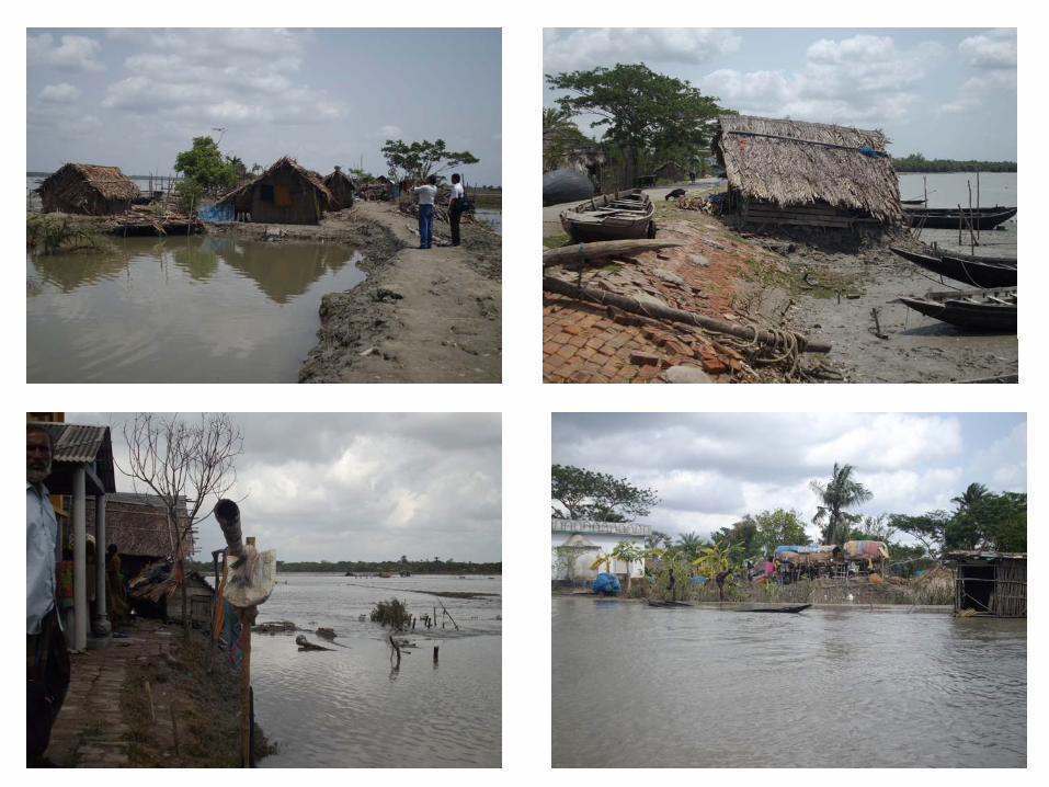
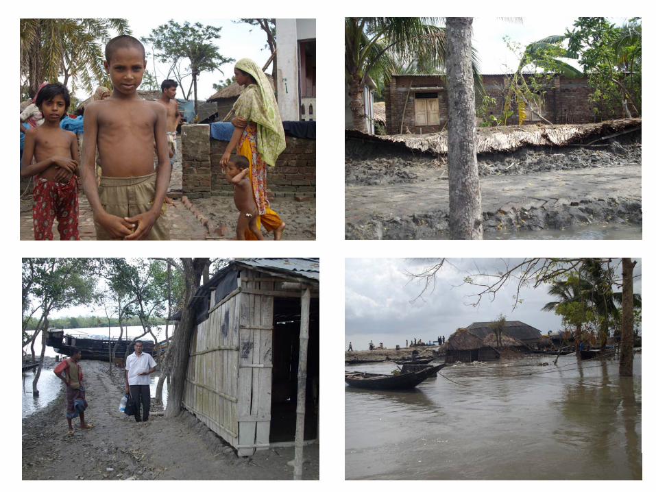
Few damage activities by cyclone Aila
ConclusionBMD monitored and forecasted the cyclones SIDR and
AILA very efficiently which help to reduce causalities andeconomy.
But improvement of forecasting related to cyclones willhelp further reduction of lives and properties.
To reduce the vulnerability and to cope up with thecyclone related disaster, improved signal system andstrategy of each organization have been incorporated inthe upgraded SOD.
THANK YOU
Gratitude to AWCI for considering Meghna River Basin of Bangladesh as one of the demonstration Basins


![Cyclone Sidr Response Program Completion Report (November ... · Cyclone Sidr Response Program Completion Report (November 2007 to May 2010 ... [16 August 2010, Dhaka, Bangladesh]](https://img.dokumen.tips/doc/110x75/5ea5356967248655ff5bd938/cyclone-sidr-response-program-completion-report-november-cyclone-sidr-response.jpg)